Rini Rachmawati*![]() | Eko Haryono
| Eko Haryono![]() | Rizki Adriadi Ghiffari
| Rizki Adriadi Ghiffari![]() | Hilary Reinhart
| Hilary Reinhart![]() | Rifqi Fathurrahman
| Rifqi Fathurrahman![]() | Amandita Ainur Rohmah
| Amandita Ainur Rohmah![]() | Farah Dewi Permatasari
| Farah Dewi Permatasari![]() | Dana Indra Sensuse
| Dana Indra Sensuse![]() | Wikan Danar Sunindyo
| Wikan Danar Sunindyo![]() | Frauke Kraas
| Frauke Kraas![]()
© 2024 The authors. This article is published by IIETA and is licensed under the CC BY 4.0 license (http://creativecommons.org/licenses/by/4.0/).
OPEN ACCESS
Jakarta and the entire Jabodetabek Region is since many years and growingly burdened by heavy symptoms of mega-urban overload. Against this background, the Indonesian government in 2019 announced the plan to relocate it to the newly built capital city, Nusantara, in the east of Kalimantan. The objective of this research is to analyze plans for sustainable development in Indonesia's new capital city. This research uses a qualitative approach through in-depth interviews with experts and spatial analysis. The results show that the capital city of Nusantara is supported by programs that include the concept of sustainable development. This is demonstrated through plans to develop large green open spaces, environmentally friendly and integrated transportation systems and modes, balanced land use, a green economy and livable and intelligent housing areas. However, it seems that there are still shortcomings in terms of disaster risk mitigation and social aspects. This needs to be followed up with additional programs in the future.
new capital, Nusantara capital city, sustainable urban development, urban development, smart city
The city of Jakarta, the capital city of Indonesia since 1945, and the entire Jabodetabek Region with over 35 million inhabitants is the second largest agglomeration in the world after Tokyo. Jakarta is experiencing strong population growth and since the past decades growingly burdened by heavy symptoms of mega-urban overload. For example, severe traffic congestion, air, water and soil pollution, sinking urban surface, multiple disaster risk damages, imbalanced growth and wide socio-economic disparities lead to severe limitations in the capital’s performance.
Jakarta or, as it is administratively called DKI (Daerah Khusus Ibukota/Special Territory of the Capital City of) Jakarta is characterized by the steadily growing population and high population density due to long periods of strong in migration from many parts of the country. The 2020 population census counts 10,56 million people which over the last decade, increased by 954,000. 88,000 people, on average, were added annually [1]. With a growth rate of 0.9% annually over the last ten years [1], the growth dynamics remained at high levels for a long time compared with similar megacities worldwide.
Among the many megacity challenges and problems, two stand out, namely traffic congestion and flooding. Based on the data obtained from the Agency of Transportation of DKI Jakarta, the number of vehicles increased by 12% annually since 2017; in 2019 data, the absolute figures mounted to 11,899,921 cars [2]. This huge number of vehicles in Jakarta is not counterbalanced by the ever since increasing amount and capacity of roads, by only 0.01% annually [2]. Consequently, high traffic congestion is inevitable in most areas of DKI Jakarta resulting in and is contributing to countless amounts of delay, economic loss and pollution [2].
Floods in DKI Jakarta are closely related to massive physical developments in the headwaters of the upper reaches of the rivers and canals that are not well managed, increasing urbanization, land use changes, and global climate change induced sea level rise [3]. Topographical factors also contribute to the flood risk, 13 rivers flow from the southern mountain regions to low topography at the shoreline, where rising sea level is a growing threat [4, 5]. Severe pollution, siltation, channeling and narrowing of rivers, canals and drains through human activities decrease the capacities of existing drainage facilities considerably, and a lack of willingness to take responsibility among the local population and government contributes as a strong catalyst for the drainage system’s deterioration [5]. Some problems are groundwater extraction for providing water to an increasing residential and commercial demand [6] and the buildings add to rapidly progressing land subsidence [5] up to 32 cm per year have been registered [7]. As much as 40%, or around 24,000 hectares of the land in DKI Jakarta in total lies in the plain lower than the sea level [8]. With persisting land use changes, this may well increase the flood risk, threatening central urban areas of Jakarta to get flooded. Assumptions estimate that flood-prone areas may reach 45 percent by 2030, with the highest damage in the central commercial areas [9], so flooding has been a concern [10, 11]. From January 31 until February 22, 2007, the till date most severe flood event ever experienced hit Jakarta [12]. About two-thirds of the city was flooded with water levels in some areas of up to four meters [12]. According to estimates, 420,000 people had to leave their homes, bringing public life to a near standstill [12]. Economic damages added up to about $967 million [13]. Informal and non-registered settlements located on riverbanks accounted for about 20% of Jakarta’s settlement area in 2007 [14]. This caused massive flooding in neighboring areas inhabited largely by socio-economically disadvantaged communities [5]. This projection accelerated plans to relocate the capital, the latest after 2007.
Through the years, several countries have relocated their capital city for various reasons e.g., improved functionality, vicinity to better resources of quality of life, escape from agglomeration diseconomies, or national security. Most often the centrality of a capital city, and its economic factors were decisive [15, 16]. Countries such as Australia, Malaysia, and Kazakhstan have successfully achieved notable improvements after they moved, including emerging regional economic performance, national stability, and improved governance in general. Myanmar, for instance, relocated its capital city from Yangon to Nay Pyi Taw most likely because of a combination of economic and political reasons [17]. The experience of Kazakhstan in relocating its capital city sparked intense debate regarding the urgency [18]. This example highlighted Kazakhstan's climatic, geographical, social, and complex historical and political aspects [18].
The new capital city of Indonesia will be constructed on a total land area of 256,142.72 hectares, including a planned core area of the government center covering an area of 6,856 hectares, a plan for a non-core area covering an area of 49,325 hectares, and an expansion area plan covering the remaining area [19]. According to the BAPPENAS [20] program implementation schedule, the construction of urban infrastructures and facilities in the new capital will occur in four phases. The first phase begins in 2020-2024 and includes the development of basic infrastructure, such as a freshwater supply system, energy, and rail transportation network system, to support the functionality of the presidential palace, parliament building, and a number of ministerial and national agencies. Meanwhile, public and social facilities such as education, health, trade, and service facilities, as well as non-government offices, will only be constructed in the non-core area so long as the core area is restricted to public use. The public, economic, and social facilities will be constructed in phases two through four.
Environmental problems faced in the cities are caused by the decrease in natural carrying capacity and the increase in disaster vulnerability. It is possible for many cities to be smart, compact, environmentally-friendly, sustainable and liveable with good urban planning to minimize impacts on the local environment [21]. Urban green open space has currently become a pivotal element of a city’s transformation into a greener and contributes to some of the key agenda issues in urban areas such as sustainability [22]. In the South East Asian, some green cities plan to have up to 60 square meters of urban green open space per capita to encourage environmental sustainability [23]. Good urban planning makes it possible for many cities to be smart, compact, environmentally-friendly, sustainable, and livable while minimizing their negative effects on the local environment [21]. Currently, urban green open space is a crucial component of a city's transformation into a greener environment and contributes to some of the most important agenda issues in urban areas, such as sustainability [22]. Some green cities in Southeast Asia plan to provide up to 60 square meters of urban green space per capita to promote environmental sustainability [23]. Each nation has its own standards and methods for measuring the green space area per capita. In Indonesia, the Ministry of Public Works and Housing has approved and endorsed a Guideline for the Provision and Utilization of Green Open Space in Urban Areas, which stipulates that cities must provide an urban community park for every 30,000 residents, with a minimum green space area of 9,00 square meters per person [24]. In some cities, such as Singapore, parks provide not only a place for people to participate in activities with their friends and family but also a place where they can experience being with others [25]. In general, relocation of a capital city is intended to create a green city and serve as a symbol for new sustainable ecologically and environmentally friendly policies, such as Indonesia's goal for its new capital city, which should be the greenest, smartest, and most sustainable capital city in the world [26]. In the 21st century, the fundamental concept of a new capital city will fully adopt new technologies such as Artificial Intelligence and the Internet of Things, which are designed with modern technology and an eco-friendly concept in mind [27]. It will have numerous green spaces where people can relax, and it is anticipated that this will increase society's standard of living and happiness. Future cities must not only be technologically advanced, but they must also consistently implement eco-friendly practices to promote urban green spaces and pro-vide clean air, water, and land [21].
Transportation master plans are necessary for the development of a new, contemporary city. Establishing a sustainable and urban transportation system is also crucial. Urban transportation and mobility are a complex system related to urban design and urban planning [28]. The development of urban areas within a car centric metropolitan area such as Jakarta is heavily influenced by private transport, and policies to increase private transport costs, such as fuel taxes and road pricing, are required [29].
Carrying Capacity (ULCC) is conceptually derived from ecological carrying capacity, with the calculation dependent on ecological considerations [30-32]. Because it operates in urban areas with high levels of socio-political elements, it involves socio-economic factors. The socio-economic constraints or factors that impact carrying capacity include land value, income, and taxes [32]. In contrast, carrying capacity is affected by several factors, including population, food production, construction, the economy, and environmental resources [33]. A growing population increases the need to satisfy hunger, necessitating the continuous expansion of farmland in the hinterland. This phenomenon induces competition between settlement and agricultural areas, resulting in land conversion [34] and even land grabbing [35, 36]. Inequality in economic strength and capital ownership makes competition more intense. Urban development must in-corporate the carrying capacity [37] to ensure that urban residents have sufficient re-sources to reside and build settlements if it is to be accomplished sustainably. The extremely rapid urbanization rate, which according to UN DESA [38] increased from 30% to 55% between 1950 and 2017, makes carrying capacity increasingly important. If the urbanization rate exceeds the carrying capacity, urban problems such as slum areas [39, 40] and urban sprawl will emerge [41, 42].
Infrastructure planning is crucial to achieving sustainable urban development. Today, infrastructure systems are typically planned independently, apart from each other and urban planning. Obviously, this incurs higher social, economic, and ecological costs than comprehensive planning. Additionally, separate infrastructure development could pose a greater threat [43]. A collaborative multi-level planning process must incorporate the local culture, be institutionally bound, and be politically motivated [44-46].
Based on the description above, it can be underlined that the capital city of Jakarta has complex urban problems. This is the dominant factor that is being considered for moving the capital to another area, namely the capital of Nusantara. Preparing the capital city of Nusantara to become a sustainable city certainly requires study. For this reason, it is important to carry out this research, namely to obtain results on which aspects will support the achievement of sustainability in the capital city of the Nusantara.
This research perceived the contributing factors of the capital city relocation as the sustainable urban development challenges and tried to formulate the supposed implementation with the roles of smart city and ICT in Nusantara Capital City. Therefore, the purpose of this study is to analyze plans for sustainable development in Indonesia's new capital city. To fulfill this objective, this research seeks to answer the research problems on what are the primary contributing factors for capital city relocation and how and why sustainable urban development is urgently needed in Nusantara Capital City Development. Data related to problems in the city of Jakarta as the old capital and related to the concept and development plans for the new capital city of Nusantara were collected through secondary data, in-depth interviews, and spatial analysis.
The capital city of Nusantara is located in East Kalimantan with an area consisting of two sub-districts from two districts, namely Samboja District which is included in Kutai Kartanegara Regency and Sepaku District which is included in North Penajam Paser Regency. The capital city of Nusantara is located close to two cities, namely Samarinda City and Balikpapan City which have an important role in East Kalimantan. The position of the capital city of Nusantara is in the middle of Indonesia so it is hoped that it can provide balance in development.
Based on the research questions and purposes of this research, we used explorative-type methods and worked mostly with qualitative data supported by spatial ones. The qualitative method is utilized to enhance understanding when comparing conceptual models and practices, or when comparing different practices. Meanwhile, spatial analysis is employed to quantify and obtain spatial details to assess some parameters. This serves as additional proof of the practices observed.
2.1 Data
Both primary and secondary data were analyzed to answer the research problems. The primary data were collected through field observation, drone photography, and the selection of documented images, serving as supporting evidence, and reinforcing the results of the in-depth interviews and literature reviews. Additionally, primary data were collected through in-depth interviews using structured ones with relevant agencies who hold critical roles in planning and developing Nusantara Capital City, such as Regional Planning Board, Regional Agency for Disaster Countermeasure (BPBD), Department of Communication and Informatics, Department of Transportation, Department of Housing and Settlement, The Regional Land Agency, The Regional Agency of Environment and Regional Secretary. In-depth interviews were also conducted with the local government up to the sub-district level, as well as with the people living in the area of the two sub-districts that will become the capital city. These stakeholders were identified and selected based on their degree of importance and influence on the development of Indonesia’s new capital city. Interviews were conducted to capture the stakeholders' perspectives and knowledge regarding the urgency of capital city relocation and the need for sustainable development in New Capital City Development. The content analysis was used to extract data and information from interview transcripts. Those resulting diverse perspectives and knowledge serve as the backbone of the analysis for this research.
The secondary data were obtained from a literature review and related policies and regulations examination, including chosen policy documents based on the suggestions from selected stakeholders who were interviewed. The development of Nusantara Capital City requires various policies and plannings and ultimately the Sustainable Urban Development framework consisting of spatial planning, and disaster analysis, including the environmental impact and carrying capacity. Those aspects were studied in several documents including Detailed Spatial Planning, Disaster Risk Study, and Environmental Carrying Capacity issued and published by related stakeholders or governmental agencies/ministries.
2.2 Analysis
Using qualitative methods and spatial analysis, the research investigated the designation that best supports the concept of sustainable urban development which also serves as the main framework used in this research and continued with comparing the findings with several cases of new capital city relocation in other countries. Descriptive and comparative analysis is also typically applied to the findings of in-depth interviews. It was used to compare the parameters determining sustainable urban development and smart city concepts with the practices implemented in the development of the new capital city, Nusantara. It is also used when comparing practices between the existing capital city, Jakarta, and the new capital city, Nusantara. In addition, GIS analysis serves primarily to support the area's physical characteristics. Spatial and GIS analysis were mainly employed to illustrate the urban carrying capacity and the disaster risk, and spatial conformity in the research area. We analyzed the carrying capacity using the ecosystem services approach, which is operationalized based on land suitability evaluation through an ecological carrying capacity framework. The ecosystem services-based carrying capacity was calculated using two parameters, eco regions and land cover to determine the pattern of 6 ecosystem service provisions. using a score method from the pairwise coefficients and the AHP-expert judgment method which is provided by the Ministry of Environment and Forestry. The scores were then classified into five classes: very low, low, medium, and high. While several disaster risks were identified using spatial overlay of hazard and vulnerability through the delta risk framework. Meanwhile, the spatial conformity analysis is used in the evaluation of the municipality’s spatial plan in the exercised areas.
The Indonesian Government considers the relocation of the capital city highly necessary due to the existing urban problems in the Capital City of Jakarta. However, to avoid the same problems reemerging in Nusantara Capital City, several issues must be prioritized and addressed using Sustainable Urban Development elements. This chapter presents the problems that become urgent in the Capital City of Jakarta and what Sustainable Urban Development elements should be implemented.
3.1 The urgency of relocating the capital of Jakarta
In the case of Jakarta as the center of government, business & trade, services and as a center of mobility, the result is that many private vehicles are the main cause of traffic jams [47]. There are 141 congestion points dispersed throughout various regions of DKI Jakarta. Using data obtained from the Agency for Transportation of DKI Jakarta in 2021, the majority of traffic congestion points are located in Central Jakarta, Western Jakarta, Eastern Jakarta, and Northern Jakarta, with 30 points in each region. Central Jakarta is the region with the highest number of reports of traffic congestion, up to 61,895 reports. On weekdays, there are more vehicles on the roads than on weekends and holidays. The proportion of private motorcycles and automobiles is the highest. Jakarta must improve its transportation infrastructure in order to lessen the spread of traffic congestion [48].
Jakarta is susceptible to flooding as well. Based on the flood history map of DKI Jakarta for the seven years between 2013 and 2020, DKI Jakarta experienced flooding annually and the flood areas in DKI Jakarta were dynamic. Between 2013 and 2015, the western and northern portions of DKI Jakarta were flooded. According to Agency for the Mitigation of Regional Disaster DKI Jakarta data, the 2013 flood in Jakarta reached between 100 and 120 centimeters, particularly in Western Jakarta. It was caused by 100 mm of rainfall per day, poor drainage, and the collapse of a dike. In 2016, the most flooded areas were in southern Jakarta, where daily precipitation averaged 100-150 mm.
In 2020, however, widespread flooding occurred throughout DKI Jakarta. It was caused by high rainfall (up to 377 mm/day), which spread from the upper to lower course, and the sea level rose to 184 cm, which was above the normal level of 100 cm, preventing land water from flowing into the sea [49]. Inadequate condition of dams and lakes, poor waste management, and groundwater depletion are additional causes of floods in Jakarta [50]. It is estimated that between 2020 and 2040, the ground in Northern Jakarta will sink between 5.4 and 5.7 cm annually [51]. Between 2025 and 2050, the rate of expansion of flooded areas in DKI Jakarta will be 3.4 times faster than between 2000 and 2015 [52]. Historiographically, the map of flood disasters in DKI Jakarta is related to the map of flood susceptibility in DKI Jakarta. This indicates that the majority of areas in DKI Jakarta are classified as having a medium-high risk of flooding, particularly in the western and northern regions. Based on the spatial pattern, the majority of flood-prone areas in DKI Jakarta are located in the northern region. They are influenced by northern elevation and morphological features, which contribute to the possibility of flooding [53]. As a result of the changing land use for buildings, the dense population of DKI Jakarta reduces the water-absorbing areas. Numerous green open spaces that formerly served as water absorbing areas have been converted into residential areas. On the basis of the satellite image, 36.22 percent of the land that should be green open spaces is instead occupied by buildings [54]. This demonstrates that the areas for buildings are more prevalent than the areas for green open spaces that still exist today [54]. Densely populated areas become a trigger for the continuous extraction of groundwater, resulting in an annual ground subsidence of 1 to 15 centimeters [51]. The changing land use in the upper course area also contributes to flooding in Jakarta, with the forest zone of DAS Ciliwung and DAS Citarum decreasing to 10% and 24%, respectively [55].
On the basis of problems of traffic congestion and flooding in Jakarta, it is urgent to move the capital to a more livable place. In addition to creating a new development center, namely in East Kalimantan, which is still supported by environmental aspects.
3.2 Emerging issues and challenges: Stakeholders’ perspective and knowledges
As noted at sub chapter 3.1, Jakarta as the existing has undergone multiple urban problems and it has become one of the main reasons for the capital city relocation. However, the capital city relocation needs to be contextualized and adjusted with the existing condition of the new location in East Kalimantan Province. The plan for capital city relocation has triggered several surfacing issues. The emerging issues and sustainability challenges have already been acknowledged by the local government and the local people at the Nusantara capital city. We have captured and summarized those issues as shown in Table 1.
From the in-depth interview we conducted, we grasped several issues that are inherently related to sustainability and aspects. Table 1 summarizes the knowledge and perceptions of several stakeholders. Environmental, economic, institutional, cultural, and infrastructure are the main concerns for the stakeholders and need to be addressed immediately as those sectors are considered to be the most impacted by the development of a new capital city. Also giving an answer on how sustainable urban development is needed in Nusantara Capital City Development through several aspects needed in the future. The next chapters provide a further synthesis for each sector.
Table 1. Challenges and issues from the related stakeholders
|
Related Stakeholders |
Challenges and Issues for Nusantara Capital City |
|
Regional Civil Administration Agency, Regional Housing and Land Agency, Regional Cultural and Tourism Agency, Regional Research and Development Agency |
|
|
Regional Food Agency, Regional Workforce and Transmigration Agency |
|
|
Regional Environmental Agency, Disaster Mitigation Board |
|
|
Local People |
|
3.3 Carrying capacity, disaster and spatial planning in the location of the new capital
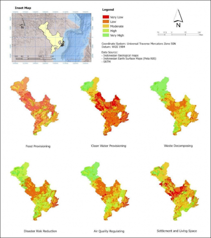
The carrying Capacity of the research location can be determined by utilizing the Urban Capacity Framework [56, 57], which is based on sustainable development points and an economic modeling approach [58]. In addition, the ecosystem services approach can be used to calculate carrying capacity [59]. Urban context related ecosystem services in the research location include water supply services, food, water quality regulation, waste decomposition, disaster risk reduction, and settlements, particularly in the relocation of the capital. The calculation of carrying capacity based on ecosystem services uses ecoregion and land use parameters, with each ecoregion and land use contributing a score to ecosystem services [60, 61]. Figure 1 demonstrates the outcomes.
Based on the map in Figure 1 of six ecosystem services used to analyze the carrying capacity of the New Capital area, the carrying capacity is low-to-moderate for ecosystem services providing food and clean water and medium-to-high for waste decomposition, disaster management, air quality regulation, and the function of settlements and living spaces. This corresponds with the primary parameters considered when determining carrying capacity based on ecosystem services, namely land use and ecoregion. The majority of the land use in the region consists of secondary forests, shrubs, and gardens, which are suboptimal for supporting food production, particularly staple foods such as rice, which require rice fields. In the meantime, low water supply services correspond to geological conditions in the form of highly saturated clay soil that is difficult to absorb water.
Figure 1. Indicative ecosystem services-based environmental carrying capacity Map. The types of ecosystem services used were selected based on their relationship to urban conditions and the new capital city
Sources: [62, 63].
National Planning Agency estimates that approximately 1.5 million people, primarily civil servants and government employees with their families, will relocate to New Capital City. It would put a tremendous strain on New Capital City's ecosystem and environment, as well as its carrying capacity. The majority of the pressure is anticipated to come from the demand for settlement, which is projected to exceed 60,000 hectares in 2045. If the authority desires Sustainable Urban Development, it must implement the sustainable cities and communities guideline [64]. The Sustainable Urban Development Goals include resilient cities and well managed carrying capacities, as indicated by the provision of ecosystem services.
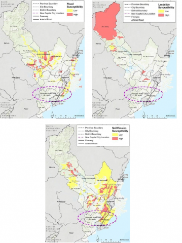
East Kalimantan was chosen as the location because it has fewer records of natural disasters, particularly geological natural disasters. According to Figure 2 and the results of in-depth interviews with the community and government agencies in North Penajam Paser Regency, there is no potential for a flood disaster in North Penajam Paser Regency.
In accordance with Presidential Regulation of the Republic of Indonesia Number 63 of 2022 Concerning Details of the Master Plan for the Capital of Nusantara, the is planned in five sub-districts: Sepaku (North Penajam Paser Regency), Samboja (Kutai Kartanegara Regency), Loa Janan (Kutai Kartanegara Regency), Loa Kulu (Kutai Kartanegara Regency (Kutai Kartanegara Regency). Circle 1 includes Sepaku Subdistrict, Penajam Paser Utara Regency, while circle 2 includes Samboja Subdistrict, Kutai Kartanegara Regency.
Institutionally, the disaster aspect in the location of the State Capital is implemented by the BPBDs of North Penajam Paser and Kutai Kartanegara for the district level, and the BPBD of East Kalimantan for the province of East Kalimantan. The primary challenges that lie ahead are the allocation of authority and the development of a comprehensive plan for the new capital of the state.
In addition, a social disaster is an additional obstacle. It is anticipated that two million people will reside in the new capital city, many of whom will be members of the State Civil Apparatus (ASN). The introduction of the ASN necessitates special care to prevent friction at the community level from escalating into open or closed conflict and a social disaster. Inequality of opportunity and social capital in gaining access to the new capital can be contributors to conflict and social disasters. In addition, if differences in educational background, values, and customs are not mitigated, the large number of migrants arriving at the site of the new capital can cause friction.
Government controlled land availability for the New Capital development is a consideration for regional advantages. Based on the Regional Spatial Plan (RTRW) of North Penajam Paser Regency in 2011-2031 and Kutai Kartanegara Regency in 2013-2033, the planned area of the new state capital contains a number of conservation areas and forest areas. The release mechanism of industrial forest plantations (HTI) and the land acquisition mechanism are utilized to provide land for IKN development (Appendix II Copy of Law No. 3 of 2022). The release of forest areas is restricted to forests in forest areas that have been converted into convertible production forests (HPK).
Figure 2. Vulnerability map of flood, landslide, and erosion hazards in the location of the new capital city
Source: [65, 66].
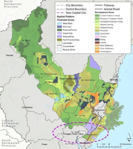
According to the RTRW maps of North Penajam Paser Regency and Kutai Kartanegara Regency, this condition implies that the conservation area and surrounding forest should also be protected (Figure 3). The dark green color in the Sepaku Subdistrict indicates that it is a production forest area whose land can be utilized if the state so chooses. As a conservation area, there is a dark purple People's Forest Plant (Botanical Garden) in the District of Samboja. These two areas should be preserved and well maintained in accordance with the concept of a green city that has been echoed. Considering the forest area and conservation, Sepaku and Samboja subdistricts are targeted for housing developments. On the map, the historical transmigration villages of the Sepaku Subdistrict are depicted in dark orange.
(a) Map of spatial pattern plan of RTRW of north Penajam Paser regency
(b) Map of spatial plan of RTRW of the regency of Kutai Kartanegara
Figure 3. Spatial planning for regencies around Nusantara capital city
3.4 Carrying capacity, disaster and spatial planning in the location of the new capital
As the new state capital, studies must be conducted on the relocation of the state capital in terms of regional readiness, including physical infrastructure readiness, food readiness, and water availability [67]. This relates to the planning and regional development aspects, particularly in anticipating and addressing the impact of potential problems that may arise after the relocation of the national capital is realized through internal and external coordination. Multiple coordination meetings with Bappenas have been held externally for the IKN planning procedure. In addition, the Regional Government fosters communication with relevant Ministries/Institutions in order to facilitate programs and activities that aid in the preparation of the Capital City. Essentially, the relocation of the capital to East Kalimantan Province will affect a variety of facets of life, ranging from economic to social to environmental concerns [67].
The Regional Government encountered the following obstacles and difficulties while preparing the capital: 1) limited budget, 2) increased skills and expertise in facing competition with newcomers, 3) the mindset of the community, 4) basic infrastructure support resources, and 5) the ego of the government sector. In addition, preparations for the relocation of the capital city must be studied further through a variety of activities, including the identification of geographic, geomorphological, demographic, and socio-cultural characteristics, the identification of the planned stages of development of the capital city area, the identification of the origin and destination of movement of people and goods, the identification of existing transportation nodes of residents, and the identification of existing transportation routes. In short, the roles of each national and regional government in this project can be seen in Table 2 below.
Table 2. Roles of the national and regional government
|
National Government |
Regional Government |
|
National budget allocation for the physical development |
Preparing the affected indigenous community to adapt to the new urbanization development |
|
Forming a special authority (Badan Otorita) to regulate development within the new capital city area |
Ensuring the connection between the new capital city and the other municipalities in East Kalimantan Province |
|
Creating the strategic area spatial plan and detailed spatial plan for the New Capital City area |
Making adjustments/revisions to the regional spatial plan in areas that affect or are affected by the new capital city development |
|
Developing new infrastructures and establishing the supply chain of the required resources |
Providing the initial primary resources and infrastructures support |
The analysis and discussion of carrying capacity, disaster and spatial planning in this study are still very limited. Further research needs to be carried out in more detail.
3.5 Topography, drainage and water availability issues
The topography of the planned area for the state capital and its environs ranges from sloping to hilly. In the western portion of the Samboja subdistrict, close to the coast, there are sloping conditions. In contrast, the terrain in some other subdistricts ranges from undulating to hilly. From the Geological Map Sheets Balikpapan and Samarinda in 1995 can be explained that this topography is influenced by structural zones of anticlinal hills and synclinal valleys extending from Samarinda to Balikpapan and from Kutai Kartanegara to Sepaku District This results in a flow pattern resembling a trellis. The drainage should be designed with care so that there are few puddles and floods. Similarly for settlement patterns. The patterns of settlement and drainage must adhere to the natural flow pattern.
The western portion of the Samboja District contains an alluvium formation, which is a deposit of material, and the terrain is generally flat. When traveling east, specifically towards the Sepaku District, the same formation exists, but the Pamaluan formation is added. This formation is composed of claystone and shale with marl, sandstone, and limestone intercalations. Outcrops of rock are visible along toll roads and company holing roads. This layer indicates that it is difficult to store groundwater in it. This causes Sepaku subdistrict to have difficulty obtaining ground water. According to information, the residents of Sotek village in the Sepaku subdistrict receive water from PDAM (Municipal Waterworks), and in some areas, they even purchase clean water because the quality of their water is poor.
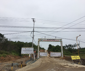
(a) Water suction in the Merdeka reservoir in Samboja sub-district
(b) Entrance road for dam construction in Sepaku district
Figure 4. Basic infrastructure near Nusantara
The hydrological conditions surrounding the proposed capital city will be comparable to those of Balikpapan, which shares the same geological formation. The Samarinda region is said to be deformed in the form of anticline folds, resulting in a folded sedimentary rock aquifer with a low groundwater potential [68]. Due to the semi-impermeable nature of the siltstone, sandy claystone, and coal that make up the majority of the constituent rocks, the potential for existing groundwater is diminished. The presence of deep groundwater provides an additional option, namely the maximization of river water and reservoir water. Figure 4 demonstrates that water is taken from reservoirs/dams based on observations made in the field. This geological condition necessitates the construction of a dam in the Sepaku District as a water reserve for the capital. To overcome the water resources obstacles, the national government through the Ministry of Public Works has built two main water reservoirs including Semoi Reservoir and Sepaku Intake. Those reservoirs not only provide clean water but also help to mitigate the flood in the Nusantara Capital City and its vicinity. Sepaku Semoi Dam is expected to be able to generate 2500 L/s with a capacity of 10 million cubic meters. Analysis of water availability at the research location needs to be further detailed through subsequent studies.
3.6 Issues and challenges of inter-city transport and mobility sectors
In the preparation of the New Capital City in East Kalimantan Province, the transportation sector is one of the fundamental infrastructure components. Improving the quality and quantity of roads is essential for enhancing the mobility of the population and facilitating interregional traffic in order to forge connections with the surrounding area.
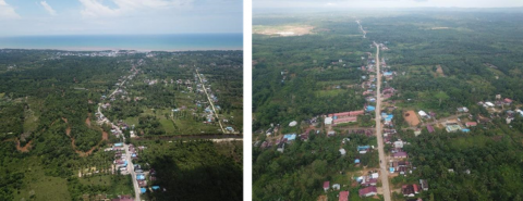
Figure 5. Samarinda toll road and km 38, supporting access to the location of the new capital city
Figure 6. Main roads in two sub-districts located in the capital city
East Kalimantan Province's capital is Samarinda City, where the governor's and provincial government's offices are located. Sepaku District is located in the northern portion of North Penajam Paser Regency, which borders Kutai Kartanegara Regency. On the Balikpapan-Samarinda toll road, the distance between Sepaku District and Samarinda City is approximately 113 kilometers and will take 1 hour and 45 minutes. At kilometer 38, the route passes through the Samboja toll gate as shown in Figure 5. This toll road between Balikpapan and Samarinda facilitates and expedites travel. The existence of the toll road, which was completed prior to the discussion of relocating the new State Capital, served as an additional link between Samboja and Sepaku. At kilometer 38, the first operating toll gate is the Samboja toll gate. In August of 2021, this toll road will have fully connected Balikpapan and Samarinda. From Balikpapan City to Samarinda City, a distance of approximately 109 kilometers, it takes 1 hour and 30 minutes by toll road. This journey on provincial roads of 135 kilometers (km) will take approximately three hours. The provincial road that connects the cities of Balikpapan and Samarinda passes through an area known as the Suharto hill. This road also links two existing sub-districts, Samboja and Sepaku, which are located within the site of the new capital city development, as depicted in Figure 6.
The existence of the new capital plan will result in the addition of new roads to connect and break up the interregional vehicle flow. Local governments prepare their spatial plans as part of regional autonomy. The regional government has published a draft of amendments to spatial planning that include plans for additional roadways. To accommodate the new state capital plan, the revision of regional spatial plans enacted through 2030 has started.
Development of the Nusantara Capital City will require the construction of many new roads as direct access to the capital city. This connectivity will facilitate the mobility of people working in the capital city. The existence of a toll road that is directly connected to the new capital city area, facilitates access from Samarinda City and Balikpapan City. The two cities have large airports that facilitate access to the Nusantara Capital City. Mobility between the new capital city, Balikpapan City, and Samarinda City has enormous potential. To summarize this chapter, the related urban problems that become contributing factors of capital city relocation and the related Sustainable Urban Development elements can be seen in Table 3 below.
Table 3. Contributing factors of relocation as the sustainable urban development challenges
|
Contributing Factors from The Capital City of Jakarta |
Sustainable Urban Development Elements |
Instruments |
|
Environmental degradation |
Carrying capacity |
Ecosystem services |
|
Disaster risk |
Urban Eco-DRR |
Community-based Disaster Response |
|
Social cohesion and political institution |
Smart Governance & Smart Society |
Strong policy and firm law enforcement |
|
Urban sprawl |
Spatial planning |
Detailed Spatial Plan |
|
Traffic Congestion |
Inter-city transports |
Mass transportation |
|
Drainage and water availability |
Sustainable water resources |
Hydrological reservoirs, watershed conservation |
3.7 Sustainable urban development for new capital city: Lessons learned
Nusantara, learning from Jakarta, must address water provision, food provision, water quality regulation, disaster risk reduction, and settlement to support carrying capacity. Central Kalimantan is an example of a region with a high capacity for food production and carbon sequestration [69]. These two ecosystem services are indispensable for the development of a sustainable urban environment in Nusantara. The current paradigm for development firmly believes that carrying capacity can be increased through the application of technology and sound policy.
Nusantara's development and infrastructure Capital City will consume the land cover and secondary forest as the predominant land cover and replace it with new buildings, roads, and other forms of physical infrastructure. It will have an effect on the vegetation and land cover in the Nusantara region, causing the forest to shrink and the carbon stock, especially biomass stocks, to decline. Carbon sequestration can be used to preserve the carbon balance at Nusantara and the green city concept of the new capital city of Nusantara [26].
In the case of Malaysia, the capital city of Kuala Lumpur was expanded into Putrajaya. This expansion model was primarily driven by the necessity of modernization and the demand for land and space as Kuala Lumpur experienced rapid urbanization accompanied by problems and challenges [70]. Putrajaya was intended to be a more digitized and technologically advanced city. It was also a pioneer in city planning, integrating Islamic identity into Middle Eastern architecture [71]. Malaysian practice is an example of the integration of advanced technology and innovative urban architecture. 2017 was the most recent instance of Yangon to Naypyidaw. Myanmar's government prepared a larger area for the new capital city. Relocation of the capital city in Myanmar involves geopolitical considerations and the centrality of the new capital city [72]. Currently, Naypyidaw is prepared for development and capable of accommodating a large population thanks to its expansive land area [15]. Canberra as the capital city does not play a prominent role as a state symbol and serves multiple functions. Instead, it aims to develop the capital city without the problems of urban density, pollution, and traffic congestion. In the future, it will be necessary to consolidate the design of the Nusantara capital city, whether as a state symbol, a solution to the problems in the old capital city, or a city that achieves environmental balance.
One of the most important strategies for achieving sustainable and environmentally friendly transportation in Egypt is to transition to energy efficient modes of transportation, such as hybrid vehicles, by utilizing new vehicle technology [73]. Green roads and highway environmental sustainability require conservation and ecosystem management, watershed driven storm water management, life cycle energy and emission reduction, recycling, reuse, and renewable, and overall societal management [74]. In the new capital city, it is necessary to provide public transportation that is both efficient and large in capacity. It also serves to integrate the surrounding cities and discourage the use of private automobiles so that the problem of traffic congestion in the old capital city can be avoided.
Table 4. Comparison matrix sustainable urban development
|
Sector |
Jakarta |
Nusantara Capital City |
|
Environment |
|
|
|
Social Culture |
Increasing urbanization |
Diverse cultures among Indigenous people, transmigrants, and spontaneous migrants |
|
Transportation and infrastructure |
Traffic congestion |
Improving the quality and quantity of roads (toll): Samarinda Toll Road and KM 38 |
|
Land and spatial planning |
Land use changes |
Government-controlled land availability for the New Capital development is a consideration for regional advantages |
According to Table 4, the absence of flood risk and the presence of two main water reservoirs indicate a strong foundation for sustainable water management. These reservoirs not only provide clean water but also help mitigate potential floods. This is a significant advantage over Jakarta, which faces challenges such as poorly managed rivers and canals, and flood risks due to extensive physical developments. The improvement in the quality and quantity of roads, marking better transportation and supporting infrastructure, suggests a commitment to enhancing connectivity and reducing congestion. This infrastructure development can promote economic growth and improve the quality of life for residents. Moreover, the government-controlled land availability for the New Capital development indicates a strategic approach to land use planning. This can allow for the creation of green spaces, efficient public transportation systems, and balanced residential and commercial areas, contributing to a sustainable urban environment. These appear to be on a promising path towards sustainable urban development in Nusantara Capital City.
However, from a socio-cultural perspective, it’s important to continually monitor and address any emerging challenges, particularly in the areas of social conflict potentials and informal land conversion. Countermeasures possibly through community engagement, inclusive policies, and conflict resolution mechanisms.
3.8 Achieving sustainable urban development of Nusantara capital city: The roles of smart city and ICT
Section 3.7 has demonstrated that in several New Capital City developments or relocations, smart city elements and ICT serve as its backbone and help to accelerate the development including achieving sustainable urban development. The same thing also prevails in Nusantara Capital City. In this case, the Indonesian Government, referring to Act Number 3 Year 2022 On State Capital City, envisages Nusantara Capital City to be a world city and aims to achieve it through urban sustainability, economic growth pole, and national identity. Further, Presidential Decree Number 63 Year 2022 On Detailed Nusantara Capital City Master Plan mandates that Nusantara Capital City be “smart” by employing Information and Communication Technology (ICT). The ICT will eventually facilitate the authority to achieve the sustainability objectives in Nusantara Capital City.
Within SDGs, through the use of technology and access to information, the smart city element will support Nusantara Capital City to fulfill Sustainable Development Goal No. 11, which stands for Sustainable Cities and Communities, in particular [75, 76]. The SDGs number 11 is directly linked to the Indonesian Government’s vision to achieve urban sustainability in Nusantara Capital City. From an economic stand-point or the second vision of Nusantara Capital City as an economic growth pole, smart cities can increase industrial sector output and productivity [77]. Environment-wise, the presence of smart environment elements and real-time monitoring of various environmental parameters is sufficient to preserve the environment's quality.
Table 5. The relationship between the dimension of development and component of the smart city in a sustainable smart city to support Nusantara capital city vision
|
SUD Elements |
Component of Smart City |
Vision of Nusantara Capital City (Referring to Nusantara Capital City Act) |
|
Inter-city Transports |
Smart Branding, Smart Economy; improvement of digital economic growth [78, 79] pushing environmentally-friendly economy through circular economy [80-83] |
Economic Growth Pole |
|
Social cohesion, strong urban political institution |
Smart People, Smart Society; improvement of interaction and sense of place virtually, opening access to information [84, 85] |
National Identity |
|
Disaster Risk, Urban Spatial Planning, Carrying Capacity, Drainage and Water Availability |
Smart Living, Smart Environment; real-time monitoring for pollution in urban areas [86-88] |
Urban Sustainability |
Due to the fact that the main concept for Nusantara Capital City's development is "Forest City," meaning that the development must be environmentally friendly, the sustainable aspect of the city's construction is crucial [89]. To ensure that sustainability is well maintained, the local government, such as the Regency of Kutai Kartanegara, must preserve unaltered land and designate a conservation area [15]. It is necessary to direct the development and regional preparation toward the development and ICT improvement, regional productivity, and infrastructure to support the economic dimensions and sustainable development, as shown in Table 5. From the environmental dimension, it is necessary for the region to improve the environmental monitoring and energy aspect that is used with one of the methods applied, i.e., smart grid [90, 91]. Meanwhile, from the sociocultural aspect, the development of smart cities needs to be focused on the components of basic services such as education, health, culture and the aspects of housing and social inclusive process [92].
This study analyzed sustainable urban development plans for Nusantara, Indonesia’s new capital city. It found that despite the city’s development is backed by programs embodying sustainable development principles, it still grapples with some shortcomings and challenges in terms of risk management and social capacity building.
As the capital city of Indonesia, Jakarta has been experiencing capacity issues including traffic congestion, disaster risk, ecological problems, and water availability. Those issues are the contributing factors for the relocation of the capital city and serve as the basis for sustainable urban development in the Nusantara Capital City. It is imperative to address those issues and design the mitigation accordingly to avoid the same problems continuing and ensure sustainability is achieved.
This research indicates that the location of the Nusantara Capital City in the East Kalimantan Province is suitable for the development of a new capital city due to its vast land resources and lower disaster risk. Hence, it can be developed through a sustainable urban development framework equipped with several instruments such as ecosystem services-based carrying capacity, integrated inter-city transportation, eco-disaster risk reduction, sustainable detailed spatial planning, and multi-level collaboration.
To achieve a sustainable city, it is necessary to consider a model for the Nusantara Capital City by comparing Nusantara’s case with other capital city relocations worldwide. From the lesson learned, this research has identified a red thread in new capital city development, which is the utilization of Information and Communication Technology (ICT) and smart city elements. To achieve sustainable development in Nusantara Capital City, several factors must be considered, including the socio-political and technological dimensions of carrying capacity management, the use of ICT-based services and the implementation of smart city. We have found and formulated the need for sustainable urban development and how the dimensions of smart city can promote it.
The research was funded by Program Riset Kolaborasi Indonesia (RKI)-World Class University, Universitas Gadjah Mada, Indonesia, through the 2022 research grant scheme, grant number 1537/UN1/DITLIT/Dit-Lit/PT.01.03/2022.
[1] Badan Pusat Statistik DKI Jakarta. (2021). Hasil Sensus Penduduk 2020 Provinsi DKI Jakarta. Jakarta.
[2] Dinas Perhubungan DKI Jakarta. (2021). Dokumen Manajemen Lalu Lintas 2021. Jakarta.
[3] Eldi, E. (2020). Analisis Penyebab Banjir Di DKI Jakarta. Jurnal Inovasi Penelitian, 1(6): 1057-1064. https://doi.org/10.47492/jip.v1i6.203
[4] Bott, L.M., Schöne, T., Illigner, J., Haghshenas Haghighi, M., Gisevius, K., Braun, B. (2021). Land subsidence in Jakarta and Semarang bay - the relationship between physical processes, risk perception, and household adaptation. Ocean & Coastal Management, 211: 105775. https://doi.org/10.1016/j.ocecoaman.2021.105775
[5] Peters, G., Butsch, C., Krachten, F., Kraas, F., Sridharan, N., Marfai, M.A. (2015). Analyzing Risk and Disaster in Megaurban Systems - Experiences from Mumbai and Jakarta. Planet@Risk, 3: 107-117.
[6] Irsyam, M., Dangkua, D.T., Hendriyawan, Hoedajanto, D., Hutapea, B.M., Kertapati, E.K., Boen, T., Petersen, M.D. (2008). Proposed seismic hazard maps of Sumatra and java islands and microzonation study of Jakarta city, Indonesia. Journal of Earth System Science, 117: 865-878. https://doi.org/10.1007/s12040-008-0073-3
[7] Abidin, H.Z., Andreas, H., Gumilar, I., Gamal, M., Fukuda, Y., Deguchi, T. (2009). Land subsidence and urban development in Jakarta (Indonesia). In 7th FIG Regional Conference, Spatial Data Serving People: LAND GOVERNANCE and the Environment, Vietnam, Hanoi, Vietnam, pp. 19-22.
[8] Maulana, A., Pradana, A.G.B. (2016). Pembelajaran penanggulangan bencana banjir di tiga daerah (Kabupaten bandung, kota surakarta, provinsi DKI Jakarta). Jakarta: Balai Pustaka.
[9] Budiyono, Y., Aerts, J.C.J.H., Tollenaar, D., Ward, P.J. (2016). River Flood risk in Jakarta under scenarios of future change. Natural Hazards and Earth System Sciences, 16: 757-774. https://doi.org/10.5194/nhess-16-757-2016
[10] Cybriwsky, R., Ford, L.R. (2001). City profile. Cities, 18: 199-210. https://doi.org/10.1016/S0264-2751(01)00004-X
[11] Zaenuddin, H.M. (2013). Jakarta Floods from Period of General JP Coen (1621) to Governor Jokowi (2013). Jakarta: Change Publisher.
[12] World Health Organization. (2007). Emergency Situation Report #4: Floods in DKI Jakarta Province, Republic of Indonesia. World Health Organization.
[13] Dartmouth Flood Observatory. (2008). Global Active Archive of Large Flood Events. Dartmouth Flood Observatory.
[14] Ooi, G.L. (2008). Cities and sustainability: Southeast Asian and European perspectives. Asia Europe Journal, 6(1): 193-204. https://doi.org/10.1007/s10308-008-0176-0
[15] Rachmawati, R., Haryono, E., Ghiffari, R.A., Reinhart, H., Permatasari, F.D., Rohmah, A.A. (2021). Best practices of capital city relocation in various countries: Literature review. E3S Web of Conferences, 325: 07004. https://doi.org/10.1051/e3sconf/202132507004
[16] Ishenda, D.K., Guoqing, S. (2019). Determinants in relocation of capital cities. Journal of Public Administration and Governance, 9(4): 200. https://doi.org/10.5296/jpag.v9i4.15983
[17] Preecharushh, D. (2010). Myanmar’s new capital city of Naypyidaw. In Engineering Earth: The Impacts of Megaengineering Projects, Dordrecht: Springer Netherlands, pp. 1021-1044. https://doi.org/10.1007/978-90-481-9919-8
[18] Gawęcki, M. (2013). New urbanization of the steppe. astana: A capital called the capital. Studia Historiae Oeconomicae, 31: 35-56. https://doi.org/10.2478/sho-2013-0003
[19] Satgas Perencanaan Pembangunan Infrastruktur IKN Kementerian PUPR. (2021). Executive Summary Urban Design Development Kawasan Inti Pusat Pemerintahan (KIPP) IKN. Kementerian PUPR.
[20] Bappenas. (2021). Buku Saku Pemindahan Ibu Kota Negara (Pocket Book of New Capital City Relocation). National Planning Agency of Indonesia.
[21] Saaty, T., De Paola, P. (2017). Rethinking design and urban planning for the cities of the future. Buildings, 7(3): 76. https://doi.org/10.3390/buildings7030076
[22] Setiowati, R., Hasibuan, H.S., Koestoer, R.H. (2018). Green open space masterplan at Jakarta capital city, Indonesia for climate change mitigation. IOP Conference Series: Earth and Environmental Science, 200: 012042. https://doi.org/10.1088/1755-1315/200/1/012042
[23] Aldous, D.E. (2011). Planning green open spaces for south east Asian capital cities. Citygreen, 1: 10. https://doi.org/10.3850/S2382581211010337
[24] Sari, D.A.K., Widyawati, L.F., Pramesti, D. (2020). The availability and role of urban green space in south Jakarta. IOP Conference Series: Earth and Environmental Science, 447: 012055. https://doi.org/10.1088/1755-1315/447/1/012055
[25] Sahakian, M., Anantharaman, M., Di Giulio, A., Saloma, C., Zhang, D., Khanna, R., Narasimalu, S., Favis, A.M., Alfiler, C.A., Narayanan, S. (2020). Green public spaces in the cities of south and southeast Asia. Protecting needs towards sustainable well-being. the journal of public space, 5(2): 89-110. https://doi.org/10.32891/jps.v5i2.1286
[26] de Vries, W.T. (2021). Urban greening for new capital cities. A meta review. Frontiers in Sustainable Cities, 3: 670807. https://doi.org/10.3389/frsc.2021.670807
[27] Hur, J.Y., Cho, W., Lee, G., Bickerton, S.H. (2019). The “smart work” myth: How bureaucratic inertia and workplace culture stymied digital transformation in the relocation of south Korea’s capital. Asian Studies Review, 43: 691-709. https://doi.org/10.1080/10357823.2019.1663786
[28] bin Abd Manan, M.A., Suprayitno, H. (2020). Preliminary overview of several capital relocations in relationship with a plan of Indonesian capital relocation. Journal of Infrastructure and Facility Asset Management, 2: 73-90. http://doi.org/10.12962/jifam.v2i1.6966
[29] Pratama, A.P., Yudhistira, M.H., Koomen, E. (2022). Highway expansion and urban sprawl in the Jakarta metropolitan area. Land Use Policy, 112: 105856. https://doi.org/10.1016/j.landusepol.2021.105856
[30] Wei, Y., Huang, C., Lam, P., Sha, Y., Feng, Y. (2015). Using urban-carrying capacity as a benchmark for sustainable urban development: An empirical study of Beijing. Sustainability, 7: 3244-3268. https://doi.org/10.3390/su7033244
[31] Tsou, J., Gao, Y., Zhang, Y., Genyun, S., Ren, J., Li, Y. (2017). Evaluating urban land carrying capacity based on the ecological sensitivity analysis: A case study in Hangzhou, China. Remote Sensing, 9: 529. https://doi.org/10.3390/rs9060529
[32] Liu, Y., Zeng, C., Cui, H., Song, Y. (2018). Sustainable land urbanization and ecological carrying capacity: A spatially explicit perspective. Sustainability, 10(9): 3070. https://doi.org/10.3390/su10093070
[33] Sun, M., Wang, J., He, K. (2020). Analysis on the urban land resources carrying capacity during urbanization—A case study of Chinese YRD. Applied Geography, 116: 102170. https://doi.org/10.1016/j.apgeog.2020.102170
[34] Rondhi, M., Pratiwi, P.A., Handini, V.T., Sunartomo, A. F., Budiman, S.A. (2019). Agricultural land conversion and food policy in Indonesia: Historical linkages, current challenges, and future directions. Current Trends in Landscape Research, 631-664. https://doi.org/10.1007/978-3-030-30069-2_29
[35] Emenyonu, C., Nwosu, A., Eririogu, H.I., Osuji, M.N., Ejike, O.U., Agbaeze, C.C. (2017). Analysis of land grabbing and implications for sustainable livelihood: A case study of local government areas in Nigeria. Journal of Economics and Sustainable Development, 8(8): 149-157.
[36] Ndi, F.A. (2017). Land grabbing, local contestation, and the struggle for economic gain. SAGE Open, 7: 215824401668299. https://doi.org/10.1177/2158244016682997
[37] Luo, W., Ren, Y., Shen, L., Zhu, M., Jiang, Y., Meng, C., Zhang, P. (2020). An evolution perspective on the urban land carrying capacity in the urbanization era of China. Science of The Total Environment, 744: 140827. https://doi.org/10.1016/j.scitotenv.2020.140827
[38] United Nations, Department of Economic and Social Affairs, Population Division. (2019). World Urbanization Prospects: The 2018 Revision. United Nations: New York.
[39] Mahabir, R., Crooks, A., Croitoru, A., Agouris, P. (2016). The study of slums as social and physical constructs: Challenges and emerging research opportunities. Regional Studies, Regional Science, 3: 399-419. https://doi.org/10.1080/21681376.2016.1229130
[40] Surya, B., Saleh, H., Abubaka, H. (2019). Sustainability of slum-based settlement management community socio-economic empowerment (Study on Slum Settlements in Panakkukang District, Makassar City). Journal of Engineering and Applied Sciences, 15: 141-152. https://doi.org/10.36478/jeasci.2020.141.152
[41] Karakayaci, Z. (2016). The concept of urban sprawl and its causes. Journal of International Social Research, 9: 815-815. https://doi.org/10.17719/jisr.20164520658
[42] Jarah, S., Zhou, B., Abdullah, R., Lu, Y., Yu, W. (2019). Urbanization and urban sprawl issues in city structure: A case of the Sulaymaniah Iraqi Kurdistan region. Sustainability, 11(2): 485. https://doi.org/10.3390/su11020485
[43] Altshuler, A.A., Luberoff, D.E. (2004). Mega-Projects: The Changing Politics of Urban Public Investment. Rowman & Littlefield.
[44] Healey, P. (2017). Making better places: The planning project in the twenty-first century. Bloomsbury Publishing.
[45] Innes, J.E., Booher, D.E., Di Vittorio, S. (2010). Strategies for megaregion governance: Collaborative Dialogue, Networks, and Self-Organization. Journal of the American Planning Association, 77(1): 55-67. https://doi.org/10.1080/01944363.2011.533640
[46] Flyvbjerg, B., Bruzelius, N., Rothengatter, W. (2003). Megaprojects and Risk: An Anatomy of Ambition. Cambridge University Press.
[47] Harmadi, S.H.B. (2016). How does congestion matter for Jakarta’s citizens? Journal of Indonesian Economy and Business, 30(3): 220-239. https://doi.org/10.22146/jieb.10312
[48] Yudhistira, M.H., Koesrindartono, D.P., Harmadi, S.H.B., Pratama, A.P. (2017). How congested Jakarta is? Perception of Jakarta’s citizen on traffic congestion. Economics and Finance in Indonesia, 62: 141. https://doi.org/10.7454/efi.v62i3.553
[49] Afiat, A., Khomsiyah, Yuda, H.F., Triany, N. (2020). The Jakarta flood disaster mapping January 2020. International Journal of Advanced Science and Technology, 29: 602-610.
[50] Garschagen, M., Surtiari, G., Harb, M. (2018). Is Jakarta’s new flood risk reduction strategy transformational? Sustainability, 10(8): 2934. https://doi.org/10.3390/su10082934
[51] Latief, H., Putri, M.R., Hanifah, F., Afifah, I.N., Fadli, M., Ismoyo, D.O. (2018). Coastal hazard assessment in northern part of Jakarta. Procedia Engineering, 212: 1279-1286. https://doi.org/10.1016/j.proeng.2018.01.165
[52] Takagi, H., Esteban, M., Mikami, T., Fujii, D. (2016). Projection of coastal floods in 2050 Jakarta. Urban Climate, 17: 135-145. https://doi.org/10.1016/j.uclim.2016.05.003
[53] Dahlia, S., Nurharsono, T., Rosyidin, W.F. (2018). Analisis kerawanan banjir menggunakan pendekatan geomorfologi Di DKI Jakarta. Jurnal Alami: Jurnal Teknologi Reduksi Risiko Bencana, 2(1): 1-8. https://doi.org/10.29122/alami.v2i1.2259
[54] Febrianti, N., Pasaribu, J.M., Sulma, S. (2015). Analisis ruang terbuka hijau di DKI Jakarta menggunakan data spot 6. Prosiding Pertemuan Ilmiah Tahunan XX dan Kongres VI Masyarakat Ahli Penginderaan Jauh Indonesia (MAPIN) 2015, 644-649.
[55] Asdak, C., Supian, S., Subiyanto. (2018). Watershed management strategies for flood mitigation: A case study of Jakarta’s flooding. Weather and Climate Extremes, 21: 117-122. https://doi.org/10.1016/j.wace.2018.08.002
[56] Ren, Y., Shen, L., Wei, X., Wang, J., Cheng, G. (2021). A guiding index framework for examining urban carrying capacity. Ecological Indicators, 133: 108347. https://doi.org/10.1016/j.ecolind.2021.108347
[57] Esfandi, S., Nourian, F. (2021). Urban carrying capacity assessment framework for mega mall development. A case study of Tehran’s 22 municipal districts. Land Use Policy, 109: 105628. https://doi.org/10.1016/j.landusepol.2021.105628
[58] Meng, C., Du, X., Ren, Y., Shen, L., Cheng, G., Wang, J. (2020). Sustainable urban development: An examination of literature evolution on urban carrying capacity in the Chinese context. Journal of Cleaner Production, 277: 122802. https://doi.org/10.1016/j.jclepro.2020.122802
[59] Millennium Ecosystem Assessment. (2005). Ecosystems and Human Well-Being: Synthesis. Island Press.
[60] Naidoo, R., Balmford, A., Costanza, R., Fisher, B., Green, R.E., Lehner, B., Malcolm, T.R., Ricketts, T.H. (2008). Global mapping of ecosystem services and conservation priorities. Proceedings of the National Academy of Sciences, 105(30): 9495-9500. https://doi.org/10.1073/pnas.0707823105
[61] Zhang, L., Lü, Y., Fu, B., Dong, Z., Zeng, Y., Wu, B. (2017). Mapping ecosystem services for China’s ecoregions with a biophysical surrogate approach. Landscape and Urban Planning, 161: 22-31. https://doi.org/10.1016/j.landurbplan.2016.12.015
[62] Dinas Lingkungan Hidup Kabupaten Lamandau. (2018). Laporan Penyusunan Daya Dukung dan Daya Tampung Lingkungan Hidup Kabupaten Lamandau.
[63] Pusat Pengendalian Pembangunan Ekoregion (P3E) Kalimantan. (2016). Deskripsi Peta Daya Dukung Ekoregion Kalimantan (Updating Tahun 2016).
[64] Azmi, M.A., Mutaali, L. (2020). Analisis daya dukung permukiman di kabupaten penajam paser utara, provinsi kalimantan timur. Jurnal Bumi Indonesia, 9: 1-14.
[65] BPBD Kutai Kartanegara. (2021). Kajian Risiko Bencana Kabupaten Kutai Kartanegara, Provinsi Kalimantan Timur 2021-2025. Tenggarong: BPBD Kutai Kartanegara.
[66] BPBD Penajam Paser Utara. (2021). Album Peta Kawasan Rawan Bencana. Penajam: BPBD Penajam Paser Utara.
[67] Rachmawati, R., Haryono, E., Rohmah, A.A., Dewi Permatasari, F., Fathurrahman, R. (2021). Smart strategies of the regional preparation for the plan of moving the new capital in the regency of Kutai Kartanegara. In Proceedings of the 2021 International Conference on ICT for Smart Society (ICISS), Bandung, Indonesia, pp. 1-7. https://doi.org/10.1109/ICISS53185.2021.9533249
[68] Devy, S.D., Hasan, H., Ugroho, W. (2017). Hidrogeologi Wilayah Samarinda, Provinsi Kalimantan Timur. In Proceedings of the Inovasi Rekayasa Sipil Dalam Menghadapi Tantangan Iklim dan Geografi Kalimantan yang Berwawasan Lingkungan, pp. 62-73.
[69] Suwarno, A., Hein, L., Sumarga, E. (2016). Who benefits from ecosystem services? A case study for Central Kalimantan, Indonesia. Environmental Management, 57: 331-344. https://doi.org/10.1007/s00267-015-0623-9
[70] Bunnell, T., Barter, P., Morshidi, S. (2002). Kuala Lumpur metropolitan area: A globalizing city-region. Cities, 19: 357-370. https://doi.org/10.1016/S0264-2751(02)00036-7
[71] Moser, S. (2010). Putrajaya: Malaysia’s new federal administrative capital. Cities, 27(4): 285-297. https://doi.org/10.1016/j.cities.2009.11.002
[72] Preecharushh, D. (2010). Myanmar’s new capital city of Naypyidaw. In Engineering Earth: The impacts of megaengineering projects, Dordrecht: Springer Netherlands, pp. 1021-1044. https://doi.org/10.1007/978-90-481-9920-4_58
[73] Abdel Wahed Ahmed, M.M., Abd El Monem, N. (2020). Sustainable and green transportation for better quality of life case study greater Cairo - Egypt. HBRC Journal, 16(1): 17-37. https://doi.org/10.1080/16874048.2020.1719340
[74] Attahiru, Y.B., Aziz, Md. M.A., Kassim, K.A., Shahid, S., Wan Abu Bakar, W.A., NSashruddin, T.F., Rahman, F.A., Ahamed, M.I. (2019). A review on green economy and development of green roads and highways using carbon neutral materials. Renewable and Sustainable Energy Reviews, 101: 600-613. https://doi.org/10.1016/j.rser.2018.11.036
[75] Diaz-Sarachaga, J.M. (2020). Combining participatory processes and sustainable development goals to revitalize a rural area in Cantabria (Spain). Land, 9(11): 412. https://doi.org/10.3390/land9110412
[76] Blasi, S., Ganzaroli, A., De Noni, I. (2022). Smartening sustainable development in cities: Strengthening the theoretical linkage between smart cities and SDGs. Sustainable Cities and Society, 80: 103793. https://doi.org/10.1016/j.scs.2022.103793
[77] Suvarna, M., Büth, L., Hejny, J., Mennenga, M., Li, J., Ng, Y.T., Herrmann, C., Wang, X. (2020). Smart manufacturing for smart cities—Overview, insights, and future directions. Advanced Intelligent Systems, 2: 2000043. https://doi.org/10.1002/aisy.202000043
[78] Allam, Z., Jones, D.S. (2021). Future (Post-COVID) digital, smart and sustainable cities in the wake of 6g: Digital twins, immersive realities and new urban economies. Land Use Policy, 101: 105201. https://doi.org/10.1016/j.landusepol.2020.105201
[79] Luo, R., Ullah, S., Ali, K. (2021). Pathway towards sustainability in selected Asian countries: Influence of green investment, technology innovations, and economic growth on CO2 emission. Sustainability, 13: 12873. https://doi.org/10.3390/su132212873
[80] Chauhan, A., Jakhar, S.K., Chauhan, C. (2021). The interplay of circular economy with industry 4.0 enabled smart city drivers of healthcare waste disposal. Journal of Cleaner Production, 279: 123854. https://doi.org/10.1016/j.jclepro.2020.123854
[81] Dindarian, A. (2022). Overview: The smart sustainable city initiatives and the circular economy. Circular Economy and Sustainability, 369-384. https://doi.org/10.1016/B978-0-12-819817-9.00004-1
[82] Balaban, O. (2019). Smart cities as drivers of a green economy. In Handbook of Green Economics, Academic Press, pp. 69-92. https://doi.org/10.1016/B978-0-12-816635-2.00005-5
[83] Chen, M., Liu, Q., Huang, S., Dang, C. (2022). Environmental cost control system of manufacturing enterprises using artificial intelligence based on value chain of circular economy. Enterprise Information Systems, 16: 1856422. https://doi.org/10.1080/17517575.2020.1856422
[84] Rachmawati, R., Hapsari, S.A., Cita, A.M. (2018). Virtual space utilization in the digital SMEs kampongs: Implementation of smart city and region. Human Geographies--Journal of Studies & Research in Human Geography, 12(1): 41-53. https://doi.org/10.5719/hgeo.2018.121.3
[85] Avdeeva, E., Davydova, T., Skripnikova, N., Kochetova, L. (2019). Human resource development in the implementation of the concept of “smart cities”. In E3S Web of Conferences, 110: 1-10. https://doi.org/10.1051/e3sconf/201911002139
[86] Abdelbacet, G., Ghada, Z., Mounir, S., Abdennaceur, K. (2015). A real time environmental monitoring for smart city surveillance based GUI on android platform. In Proceedings of the 2015 IEEE 12th International Multi-Conference on Systems, Signals & Devices (SSD15), Mahdia, Tunisia, pp. 1-6. https://doi.org/10.1109/SSD.2015.7348137
[87] Malche, T., Tharewal, S., Pallavi Bhatt, D. (2021). A Portable water pollution monitoring device for smart city based on Internet of Things (IoT). IOP Conference Series: Earth and Environmental Science, 795: 012014. https://doi.org/10.1088/1755-1315/795/1/012014
[88] Wong, M., Wang, T., Ho, H., Kwok, C., Lu, K., Abbas, S. (2018). Towards a smart city: Development and application of an improved integrated environmental monitoring system. Sustainability, 10: 623. https://doi.org/10.3390/su10030623
[89] Mutaqin, D.J., Muslim, M.B., Rahayu, N.H. (2021). Analisis konsep forest city dalam rencana pembangunan Ibu Kota Negara. Bappenas Working Papers, 4(1): 13-29. https://doi.org/10.47266/bwp.v4i1.87
[90] Archana. (2022). Modelling barriers for smart grid technology acceptance in India. Process Integration and Optimization for Sustainability, 6(4): 989-1010. https://doi.org/10.1007/s41660-022-00255-1
[91] Hargreaves, N., Hargreaves, T., Chilvers, J. (2022). Socially smart grids? A multi-criteria mapping of diverse stakeholder perspectives on smart energy futures in the United Kingdom. Energy Research & Social Science, 90: 102610. https://doi.org/10.1016/j.erss.2022.102610
[92] Kolotouchkina, O., Barroso, C.L., Sánchez, J.L.M. (2022). Smart cities, the digital divide, and people with disabilities. Cities, 123: 103613. https://doi.org/10.1016/j.cities.2022.103613