Peishan Fan![]() | Yunfei Zhou
| Yunfei Zhou![]() | Shifan Tong*
| Shifan Tong*![]()
© 2025 The authors. This article is published by IIETA and is licensed under the CC BY 4.0 license (http://creativecommons.org/licenses/by/4.0/).
OPEN ACCESS
The sustainable management of natural resources in tourist attractions is a core issue in the collaborative development of ecological conservation and the tourism industry. Traditional manual monitoring methods suffer from limitations such as restricted coverage and delayed responses, making them unsuitable for large-scale, round-the-clock real-time monitoring needs. Computer vision technology offers an efficient solution for this domain, but challenges such as significant variations in lighting, unclear boundaries between resource types, and strong heterogeneity in texture features make it difficult for conventional image processing methods to achieve the segmentation accuracy and real-time performance required for quantitative assessments. Existing research shows significant shortcomings in key areas such as edge detection, feature extraction, and clustering segmentation: traditional edge detection operators often produce broken or false edges, single-feature representations struggle to address resource feature heterogeneity, manually set clustering parameters fail to adapt to dynamic distributions, and pixel-level clustering faces computational bottlenecks. To address these issues, this paper proposes an improved superpixel segmentation method for real-time monitoring of natural resources in tourist attractions. The specific research includes: 1) constructing a superpixel segmentation model to improve edge extraction accuracy and noise resistance; 2) integrating multi-dimensional features, normalizing and reducing their dimensions to build high-discriminative feature vectors; 3) using the density peak algorithm to adaptively determine the number of clusters, avoiding manual intervention; and 4) performing fuzzy C-means clustering on superpixels to optimize segmentation in transitional areas and improve efficiency. The innovation of this method lies in: 1) replacing traditional edge detection operators with structured edge detection to solve robustness issues in complex scenes; 2) developing a multi-dimensional feature fusion system to overcome the limitations of single-feature representation; 3) introducing an adaptive clustering parameter mechanism to accommodate dynamic resource distribution; and 4) combining superpixels with fuzzy C-means clustering to ensure segmentation accuracy while meeting real-time demands. This method provides technical support for the precise identification, dynamic monitoring, and quantitative evaluation of natural resources in tourist attractions, contributing to the fine-grained management and sustainable development of scenic areas.
tourist attractions, natural resource monitoring, computer vision, superpixel segmentation, feature fusion, adaptive clustering
With the rapid development of the global tourism industry and the increasing awareness of ecological environmental protection [1-3], the sustainable management of natural resources in tourist attractions [4, 5] has become a key issue that needs to be addressed. The natural resources in tourist attractions, such as vegetation, water bodies, and rocks, are not only core elements of the scenic ecosystem but also serve as important landscape foundations that attract tourists. Changes in their status directly affect the ecological safety and tourism experience of the scenic area. However, traditional natural resource monitoring methods [6-9], which rely on manual inspections and fixed-point sampling, have limitations such as limited coverage, delayed response, and high labor costs, making them unsuitable for large-scale, round-the-clock real-time monitoring needs of tourist attractions. Computer vision technology [10, 11], with its advantages of non-contact sensing and efficient data acquisition, provides a new technical path for dynamic monitoring of natural resources. However, its application in complex tourism scenarios still faces challenges—issues such as significant lighting changes, blurred boundaries between resource types, and strong heterogeneity in texture features lead to difficulties in achieving the segmentation accuracy and real-time performance required for quantitative assessments using traditional image processing methods. These challenges limit the deep application of computer vision technology in the management of natural resources in tourist attractions.
Conducting research on the real-time monitoring and assessment of natural resources in tourist attractions using computer vision has significant theoretical and practical value. In practical terms, this research enables the rapid identification and dynamic tracking of ecological issues such as vegetation degradation, water pollution, and rock weathering, providing precise decision-making support for scenic area management departments. This can help in formulating scientific ecological protection strategies and tourism development plans, achieving the collaborative development of ecological protection and the tourism industry. In theoretical terms, this research explores high-precision and robust image processing methods tailored to the specificities of tourist scenarios, enriching the application of computer vision technology in ecological monitoring. It provides new research ideas for cross-disciplinary technology integration and promotes the transformation of natural resource monitoring technology from traditional manual methods to intelligent and automated models.
Although existing research has made some progress in combining computer vision and natural resource monitoring, there are still many flaws and deficiencies. Traditional edge detection algorithms, such as the Sobel operator [12], rely solely on color gradients to extract edge information, which tends to generate broken edges and false edges when dealing with complex textures and lighting changes in scenic areas, resulting in a decline in subsequent segmentation accuracy. In feature extraction, some studies only use single texture or color features for resource type identification [13, 14], which are insufficient to address the feature heterogeneity of natural resources in scenic areas. For example, using only Local Binary Pattern (LBP) features [15] cannot fully capture the global texture differences between different vegetation types, leading to high misclassification rates. In clustering and segmentation, most methods rely on manually setting the number of clusters [16, 17], which cannot adapt to the dynamic changes in resource distribution in scenic areas. For example, the K-means algorithm [18], with its hard clustering characteristics, struggles to handle the fuzzy features of resource transition areas, while traditional fuzzy C-means clustering algorithms [19, 20] directly operate on pixel-level data, leading to low computational efficiency and failing to meet real-time monitoring demands. These issues seriously affect the application effectiveness of computer vision technology in the natural resource monitoring of tourist attractions, highlighting the urgent need to establish an image processing method system that balances both accuracy and efficiency.
This paper focuses on the core requirements of real-time monitoring and assessment of natural resources in tourist attractions and proposes an improved superpixel segmentation-based computer vision processing method. The core research content includes: first, replacing the traditional Sobel operator with structured edge detection, combined with multi-scale morphological gradient reconstruction watershed transformation to generate high-precision, noise-resistant superpixel images; second, integrating complementary texture features of Gabor and LBP, multi-color space statistical features, and spatial location features, normalizing and performing Principal Component Analysis (PCA) dimensionality reduction to construct high-discriminative feature vectors; third, using the density peak algorithm to adaptively determine the number of clusters, avoiding manual intervention; and fourth, performing fuzzy C-means clustering on superpixels to accurately process resource transition areas and improve computational efficiency. The core value of this research lies in the fact that through multi-technology integration, it breaks through the accuracy bottleneck of traditional methods. With adaptive parameter adjustment and optimized computational units, it meets the large-scale real-time monitoring demands, ultimately providing technical support for the fine-grained management of natural resources in scenic areas, promoting the coordinated advancement of ecological protection and sustainable tourism development.
2.1 Problem description and method overview
Real-time monitoring and assessment of natural resources in tourist attractions is the core technical support for achieving the coordinated advancement of ecological protection and sustainable tourism development. The primary objective is to use computer vision technology to accurately capture key ecological indicators, such as dynamic vegetation cover, changes in water body area, degree of rock weathering, and pollutant distribution, and provide reliable pixel-level data support for quantitative assessment. However, the complex scene characteristics of tourist attractions pose multiple technical challenges to image processing tasks: First, the boundaries of natural resource types are highly ambiguous, such as the transitional zone between vegetation and bare land, and the interface between shallow water areas and tidal flats. Traditional segmentation methods are prone to boundary confusion, leading to insufficient resource classification accuracy. Second, resource features are significantly affected by environmental factors; lighting changes and seasonal transitions can cause color feature drift, while the texture heterogeneity of different resource types further complicates feature differentiation. Third, the real-time monitoring scene requirements impose dual constraints on algorithm performance, as they need to process vast amounts of image data generated by large-scale monitoring to meet timeliness requirements, while also adapting to the dynamic changes in resource distribution, avoiding inefficiencies and subjective biases caused by manual parameter adjustments. Fourth, the pixel assignment problem in transition areas directly affects the accuracy of subsequent evaluation metric calculations, and traditional hard segmentation methods are difficult to adapt to such scenarios. The presence of these issues severely restricts the practical application of computer vision technology in the monitoring and assessment of natural resources in tourist attractions, highlighting the urgent need to develop an image processing method that combines high precision, high efficiency, and strong adaptability.
To address the above research issues, this paper chooses a superpixel segmentation method that integrates edge enhancement, hybrid feature fusion, and adaptive clustering as the core image processing technique. The rationality and necessity of this method stem from its precise adaptation to the research goals and the targeted utilization of its technical advantages. From the precision assurance dimension, this method enhances edges through the cooperation of a structured edge detection algorithm and a watershed transform algorithm based on multi-scale morphological gradient reconstruction. It can effectively solve the problem of ambiguous boundaries between different natural resource types, providing an accurate spatial positioning foundation for subsequent segmentation, avoiding resource classification confusion caused by boundary errors, and directly supporting the accurate calculation of assessment metrics such as vegetation cover and water pollution extent. In terms of feature representation, the design that integrates LBP and Gabor texture features can fully capture the texture details of resource types. Coupled with the deep integration of color features, it can resist interference from environmental factors such as lighting and seasonal changes in feature extraction, significantly improving the differentiation of different resource types in complex scenes. From the efficiency and adaptability perspective, this method achieves high-precision boundary extraction with a single superpixel segmentation, greatly reducing computational complexity compared to traditional multi-round segmentation methods, enabling the fast processing of massive monitoring images, and meeting the timeliness requirements for large-scale, round-the-clock real-time monitoring in tourist attractions. The introduction of the density peak algorithm allows for the automatic determination of the number of clusters, effectively adapting to the dynamic changes in resource distribution and regional differences in tourist attractions, avoiding the efficiency bottlenecks and subjective biases caused by manual parameter adjustments. Furthermore, the soft segmentation nature of the fuzzy C-means clustering algorithm can appropriately address the pixel assignment issue in resource transition areas, further compensating for the technical shortcomings of traditional segmentation methods and providing high-quality data support for subsequent quantitative assessment, ultimately achieving a deep alignment between the technical solution and research objectives.
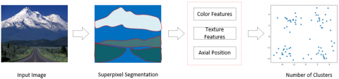
Figure 1. Core steps of the proposed method
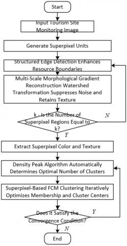
Figure 2. Flowchart of the core technical chain of the proposed method
The superpixel segmentation method for real-time monitoring of natural resources in tourist attractions proposed in this paper follows the technical chain of "preprocessing-feature optimization-parameter adaptation-precise segmentation." Figure 1 shows the schematic diagram of the core steps of this method. In the preprocessing stage, the structured edge detection algorithm and the watershed transform algorithm based on multi-scale morphological gradient reconstruction are used in coordination to enhance image edge information: the structured edge detection algorithm enhances the edge response of different resource types, highlighting key boundaries; the watershed transform algorithm based on multi-scale morphological gradient reconstruction suppresses environmental noise while retaining resource texture details, generating preprocessed images with clear edge contours and strong anti-interference capability. In the feature optimization stage, multi-dimensional feature vectors are constructed: by integrating the local detail description ability of LBP texture features with the multi-scale, multi-directional representation advantages of Gabor texture features, a mixed texture feature set is formed, while color features are also integrated to characterize different resource types. In the parameter adaptation stage, the density peak algorithm is introduced to automatically identify the density peak points in the feature space to determine the optimal number of clusters, adapting to the resource distribution characteristics of different monitoring areas. In the precise segmentation stage, based on the optimized multi-dimensional feature vectors and the adaptive clustering parameters, the fuzzy C-means clustering algorithm is used to perform the superpixel segmentation operation, using its soft segmentation feature to handle the pixel assignment problem in resource transition areas, and obtaining precise segmentation results with accurate boundaries through a single segmentation. Figure 2 shows the flowchart of the core technical chain of this method.
2.2 Superpixel segmentation
The proposed superpixel segmentation method for real-time monitoring of natural resources in tourist attractions focuses on improving edge extraction accuracy. By integrating structured edge detection with multi-scale morphological gradient reconstruction-based watershed transform, it addresses the problem of blurred edges and poor noise resistance in traditional segmentation methods for complex tourist scenes, laying the foundation for subsequent precise segmentation of natural resource types. This stage directly serves the research goal of real-time monitoring and assessment of natural resources in tourist attractions, namely, to accurately capture the boundary information of resources such as vegetation, water bodies, and rocks, supporting the quantitative analysis of key metrics such as resource distribution and dynamic changes.
The core improvement of the superpixel segmentation stage lies in the optimization of the edge extraction method. The traditional multi-scale morphological gradient reconstruction-based watershed transform algorithm relies on the Sobel operator to generate edge images. However, the Sobel operator only identifies edges by calculating color gradient magnitude, which has significant limitations in complex tourist scenes: for example, visual prominent edges such as texture boundaries formed by overlapping leaves in dense vegetation, light and dark alternating areas caused by light reflection on water bodies, and fine contours formed by rock weathering, often have weak correlations with color gradients, causing edges extracted by the Sobel operator to be broken, false, or mislocated. These problems directly affect the segmentation results of the watershed transform based on multi-scale morphological gradient reconstruction, potentially misclassifying adjacent vegetation and bare land areas as the same category or incorrectly segmenting reflective areas of water bodies as independent regions, ultimately interfering with the accuracy of natural resource status assessment. Therefore, the introduction of structured edge detection algorithms to replace the Sobel operator becomes the key improvement direction for enhancing edge extraction accuracy.
The reason why structured edge detection algorithms are suitable for edge extraction of natural resources in tourist attractions lies in their deep ability to mine "structured features." This algorithm computes based on the intrinsic structural information of local image blocks, using a structured learning framework combined with a random decision forest, specifically designed to solve the problem of predicting local edge masks. In tourist scenes, the edges of natural resources often have significant local correlations. For example, the edges between water bodies and shorelines maintain consistent directions in continuous image blocks, and the boundaries of vegetation communities show continuous transitional trends in adjacent pixels. By learning these associations, structured edge detection can break through the limitations of a single-color gradient, capturing "real edges" that align more closely with human visual perception, especially suitable for handling the edge extraction challenges caused by complex textures, lighting changes, and noise interference in tourist attractions.
The computational mechanism of structured edge detection achieves precise encoding and selection of edge features through two key steps: "intermediate mapping" and "information gain selection," which are highly adaptable to the edge characteristics of natural resources in tourist attractions. In the intermediate mapping stage, the algorithm maps the edge labels of the output space Y to a high-dimensional space Z and approximates the dissimilarity of the labels by calculating the Euclidean distance in Z. For example, for a 16×16 image block, binary vector encoding is used to represent whether pixel pairs belong to the same resource region, such as "vegetation-vegetation" or "vegetation-bare land," thus precisely capturing edge details in small areas, such as the boundary between coniferous and broad-leaved forests. The specific mapping formula is:
$\Pi: Y \rightarrow Z$ (1)
Considering the computational cost of high-dimensional space, the algorithm simplifies the mapping and uses PCA dimensionality reduction to retain distance approximation while removing noise, addressing interference issues caused by camera noise and atmospheric scattering in tourism monitoring images.
In the information gain selection stage, structured edge detection maps the high-dimensional space labels to a discrete set, ensuring global consistency of edge features. The algorithm uses K-means clustering or PCA quantization for mapping, allowing similar edge features to be assigned the same discrete label, and then selects the most discriminative features using Shannon entropy or Gini impurity. This process is independently performed for each decision tree node and can adapt to the resource distribution characteristics of different regions. For example, in the water area, the algorithm prioritizes learning "smooth continuous edge" features to distinguish shorelines; in the vegetation area, it focuses on "texture gradient edge" features to identify community boundaries. This adaptive capability allows the algorithm to simultaneously handle diverse edge types in tourist attractions, with the output edge images retaining fine textures while maintaining global continuity.
Finally, the high-precision edge images generated by structured edge detection are input into the watershed transform algorithm based on multi-scale morphological gradient reconstruction, forming an improved superpixel segmentation process. Compared with traditional methods, the superpixel boundaries output by this method are more aligned with the actual distribution of natural resources. For example, in lake monitoring, it accurately segments the fuzzy transition zone between water bodies and shoreline vegetation; in forest monitoring, it clearly distinguishes the boundaries of different tree species communities. This precise superpixel segmentation provides reliable spatial units for subsequent feature extraction and clustering analysis, directly supporting the real-time monitoring and quantitative assessment of natural resources in tourist attractions and achieving a deep coupling of technological improvements and research goals.
2.3 Color and texture feature extraction and fusion
In the color and texture feature extraction and fusion stage, this paper adopts a strategy combining Gabor texture features and LBP texture features to fully capture texture information at different scales and details, laying the foundation for accurate differentiation of resource types. Natural resources in tourist attractions, such as coniferous forests, broad-leaved forests, calm water bodies, turbulent water, and weathered rocks, have significant texture differences. The global texture of vegetation communities exhibits regular distribution, while local details such as overlapping leaves and rock cracks form fine textures. Additionally, lighting changes, seasonal transitions, and other factors easily lead to dynamic fluctuations in texture features. Gabor filters, with their excellent ability to select directions and scales, can effectively capture global texture information at different directions and scales and have strong robustness to lighting changes and slight image rotation deformations, making them highly adaptable to dynamic texture changes such as water reflections and vegetation swaying in the wind in tourism scenes. Specifically, assume that the input image is represented by d(a, b), where L is the L channel in the Lab color space. The scale and direction of the Gabor filter are represented by μ and ϕ, and the Gabor filter is denoted by h. The expression formula for Gabor texture features is:
$D(a, b, \phi, \mu)=d(a, b) * h(a, b, \phi, \mu)$ (2)
Assume the normalization factor is represented by X, and the Gabor filter definition formula is:
$\left\{\begin{array}{l}h(a, b, \phi, \mu)=X \exp \left(-a^2 / \delta_a^2-b^{\prime 2} / \delta_b^2\right) \cos \left(\mu a^{\prime}\right) \\ a^{\prime}=a \operatorname{COS} \phi+b \operatorname{SIN} \phi \\ b^{\prime}=a \operatorname{SIN} \phi-b \operatorname{COS} \phi\end{array}\right.$ (3)
To further optimize the quality of Gabor features, the algorithm smooths its amplitude information using a Gaussian low-pass filter, reducing interference caused by local texture fluctuations, and uses the PCA algorithm to reduce the 16-dimensional feature map to a 1-dimensional vector to improve computational efficiency, ensuring the performance requirements of real-time monitoring.
LBP features focus on the extraction of local texture details. Their high sensitivity to subtle texture changes and scale invariance perfectly compensates for Gabor features' limitations in characterizing local details. For example, when distinguishing between different tree species in vegetation areas, LBP features can precisely capture the local differences in leaf arrangement, while Gabor features characterize the global texture distribution pattern of vegetation communities. The complementary combination of both effectively reduces the misclassification rate of single features in complex tourism scenes, providing a comprehensive texture representation foundation for subsequent accurate clustering of resource types.
To overcome the interference of lighting, seasonal, and other factors on color features in tourism scenes, the algorithm selects three color spaces—RGB, HSV, and Lab—and extracts the first-order and second-order moments of each color component as color features to provide comprehensive and robust representation of natural resource color information. Different color spaces have varying sensitivities to environmental changes: RGB space reflects raw color information, HSV space better aligns with human color perception, and Lab space has good color separation characteristics, which can effectively resist color drift caused by lighting changes. For example, in vegetation monitoring during winter and summer, color features in the Lab space can more stably reflect changes in vegetation growth; in water body monitoring, the saturation component in the HSV space can accurately distinguish between clean and polluted water. At the same time, the algorithm incorporates spatial location features, fully considering the spatial distribution patterns of natural resources in tourist attractions, such as water bodies being concentrated in low-lying areas and vegetation being distributed on hillsides or plains. By using spatial location information to assist in distinguishing resources of similar color and texture features but different types, the discriminative ability of features is further enhanced.
To achieve effective integration of multi-dimensional features, the algorithm uses feature concatenation to combine color features, texture features, and spatial location features into high-dimensional feature vectors. These vectors are then normalized using Z-score normalization to eliminate dimensional differences between features, avoiding feature weight imbalance caused by differences in value ranges. Considering the computational efficiency requirements of real-time monitoring and the potential redundancy in high-dimensional features, the algorithm uses PCA to reduce the dimensionality of the fused feature vector. This reduces data dimensions and the computational complexity of subsequent clustering tasks while retaining key discriminative information, ensuring that the algorithm can quickly process massive monitoring images of large-scale tourist attractions.
The feature vectors optimized through the above process comprehensively integrate the color, texture, and spatial attributes of the superpixel blocks, enabling precise characterization of different types of natural resources and providing high-quality input for the automatic determination of the number of clusters and fuzzy C-means clustering segmentation.
2.4 Determination of the number of clusters
In the clustering number determination stage, this paper introduces the density peak algorithm. The core objective is to address the dynamic heterogeneity of natural resource distribution in tourist sites, achieving precise matching between the number of clusters and actual resource types, avoiding subjective biases and efficiency bottlenecks caused by manual setting of clustering parameters, and providing a scientific parameter basis for subsequent fuzzy C-means clustering segmentation. The natural resource types in tourist attractions are complex and subject to dynamic changes in distribution: on the one hand, there are significant differences in resource combinations across different regions, such as mountainous areas dominated by vegetation and rocks, and waterfront areas dominated by water bodies and wetlands; on the other hand, seasonal changes and environmental factors cause dynamic adjustments to resource type boundaries and distribution ranges, such as the expansion of vegetation in summer and the change in the area of frozen water bodies in winter. Manually setting the number of clusters is difficult to adapt to these dynamic changes. If the number of clusters is too few, different resource types will be misclassified as the same category, affecting the accuracy of evaluation indicators. If the number of clusters is too many, excessive segmentation will occur, increasing computational costs and interfering with the effective identification of resource types, which cannot meet the real-time monitoring requirements. The Density Peak Algorithm, driven by data, automatically uncovers the distribution pattern of superpixel features, which is well-suited to the core demands of the tourism scene.
The Density Peak Algorithm determines the number of clusters automatically by calculating two key indicators: local density ϑu and minimum distance σu. For each superpixel block, the local density ϑu is calculated based on the Euclidean distance fuk between superpixels and truncation distance fz, reflecting the density of similar superpixels around that superpixel. Specifically, assuming the number of the k-th superpixel area is represented by Tk, and the total number of superpixels by V, the calculation formula is:
$\vartheta_u=\sum_{k=1, k \neq u}^V T_k \exp \left(-f_{u k}^2 / f_z\right)$ (4)
In the tourism scene, superpixels of the same resource type typically have similar features and small Euclidean distances, resulting in higher local densities, while superpixels of different resource types show significant feature differences and larger Euclidean distances, resulting in lower local densities.
The minimum distance σu is defined as the minimum Euclidean distance between the superpixel and all higher-density superpixels, used to distinguish the core areas of different resource types. The specific calculation formula is:
$\sigma_u=\underset{k: \vartheta_k>\vartheta_u}{\operatorname{MIN}}\left(f_{u k}\right)$ (5)
In practice, the core superpixels in water body regions, due to their strong feature specificity, will have a significantly larger distance from other high-density superpixels than other regions. For the superpixels with the highest density, the algorithm defines their minimum distance σu separately to ensure the accurate identification of core resource types. For the superpixel region with the highest density, fuk is defined as:
$f_{u k}=\left\|\frac{1}{T_u} \sum_{o \in E_w} a_o-\frac{1}{T_k} \sum_{o \in E_k} a_w\right\|$ (6)
The decision graph of superpixels is derived from ϑu and σu:
$\theta_u=\vartheta_u \sigma_u$ (7)
After constructing the decision graph based on ϑu and σu, the algorithm analyzes the distribution characteristics of points in the graph to identify the density peak points. Each peak point corresponds to a core cluster of a natural resource type, automatically determining the optimal number of clusters. For example, in a tourist scene containing water bodies, coniferous forests, broad-leaved forests, and bare land, the decision graph will form four distinct density peak points corresponding to four core resource types. This data-driven automatic decision-making mechanism not only avoids the cumbersome process of manual parameter adjustment but also adapts to the resource distribution characteristics of different tourism scenes, ensuring that the number of clusters aligns closely with the actual resource types. Ultimately, this stage provides precise parameter input for the subsequent fuzzy C-means clustering, ensuring the accuracy of segmentation results.
2.5 Superpixel-based fuzzy C-means clustering
The core objective of this stage is to use the soft clustering properties of the fuzzy C-means algorithm to precisely handle the boundary transition problems of natural resource types in tourist attractions and achieve efficient clustering and segmentation at the superpixel level, providing reliable category division results for subsequent real-time monitoring and quantitative evaluation of resource conditions. The natural resource distribution in tourist attractions generally exhibits significant transition characteristics: for example, the gradient zone between vegetation and bare land, the boundary between shallow water areas and tidal flats, and the mixed areas of different vegetation communities. The pixel features of these regions are fuzzy, and traditional hard clustering algorithms force each pixel to be assigned to a single category, which often leads to distorted boundary segmentation and affects the accuracy of resource area calculation, type identification, and other evaluation indicators. The fuzzy C-means clustering algorithm, by introducing the concept of membership degree, allows each superpixel to belong to multiple clustering categories simultaneously and quantifies its degree of membership. This is well-suited for the feature fuzziness of natural resource transition areas, allowing for a more realistic reflection of the spatial distribution patterns of resource types. Additionally, its stronger hierarchy and stability compared to hard clustering further ensure the reliability of segmentation results in complex tourism scenes.
The core logic of this stage revolves around the optimization of the objective function of the fuzzy C-means clustering algorithm. The objective function minimizes the weighted sum of squared distances between superpixel features and clustering centers, achieving optimal category division, with parameter designs highly compatible with the characteristics of natural resources in tourist attractions. The specific objective function expression is:
$K_l=\sum_{k=1}^V \sum_{s=1}^j T_k i_{k s}^l\left\|\left(\frac{1}{T_k} \sum_{o \in E_k} a_o\right)-z_s\right\|^2$ (8)
In the objective function, the membership matrix iks quantifies the degree of membership of the k-th superpixel to the s-th resource category. For example, superpixels in the transition zone between vegetation and bare land will have membership degrees to both the "vegetation" class and the "bare land" class between 0 and 1, with their sum satisfying the fuzzy set constraint. The clustering center zs represents the core feature vector of a certain natural resource category, integrating the color, texture, and spatial location features of that resource. The fuzziness factor l is usually set to 2, balancing the fuzziness and distinguishability of the clustering, avoiding category confusion due to excessive fuzziness, and reserving reasonable space for the feature expression of transition areas. In addition, the objective function introduces the number of pixels Tk in the superpixel area as a weight, so that larger resource areas occupy more important weight in the clustering optimization, aligning with the dominant position of dominant resource types in tourist attractions, and ensuring that the clustering results accurately reflect the spatial proportion relationships of resources.
Superpixel-based fuzzy C-means clustering achieves convergence of clustering results through a systematic iterative optimization process. At the same time, relying on the preprocessing advantages of superpixels, it meets the efficiency requirements of real-time monitoring in tourism scenes. Its iterative process follows the logic of "initialization-update-convergence judgment": first, the membership matrix is randomly initialized, combining the number of clusters k, which is automatically determined by the density peak algorithm in the previous section (i.e., the actual number of core resource types in the tourist attraction), to provide initial parameters for the iteration; then, using the analytical solution derived from the Lagrange multiplier method, the clustering center and membership matrix are alternately updated. The optimization problem is transformed using the Lagrange multiplier η, as follows:
$\begin{aligned} & K_l=\sum_{k=1}^V \sum_{s=1}^j T_k i_{k s}^l\left\|\left(\frac{1}{T_k} \sum_{o \in E_k} a_o\right)-z_s\right\|^2 -\eta\left(\sum_{k=1}^j i_{k s}-1\right)\end{aligned}$ (9)
Furthermore, partial differential equations of Kl with respect to zs and iks are calculated as follows:
$\begin{aligned} & \frac{\partial K_l}{\partial i_{k s}}=\sum_{k=1}^V \sum_{s=1}^j \frac{\partial T_k i_{k s}^l\left\|\left(\frac{1}{T_k} \sum_{o \in E_k} a_o\right)-z s\right\|^2}{\partial i_{k s}}-\eta =\sum_{k=1}^V \sum_{s=1}^j l T_k i_{k s}^{l-1}\left\|\left(\frac{1}{T_k} \sum_{o \in E_k} a_o\right)-z_s\right\|^2-\eta^{\prime} =0\end{aligned}$ (10)
$\begin{aligned} & \frac{\partial K_l}{\partial z_s}=\sum_{k=1}^V \sum_{s=1}^j \frac{\partial T_k i_{k s}^l\left\|\left(\frac{1}{T_k} \sum_{o \in E_k} a_o\right)-z_s\right\|^2}{\partial z_s} =\sum_{k=1}^V \sum_{s=1}^k T_k i_{k s}^l \frac{\partial\left\|\left(\frac{1}{T_k} \sum_{o \in E_k} a_o\right)-z_s\right\|^2}{\partial z_s} =\sum_{k=1}^V T_k i_{k s}^l \frac{\partial\left\|\left(\frac{1}{T_k} \sum_{o \in \varepsilon_s} a_o\right)-z_s\right\|^2}{\partial z_s} =-2 \sum_{k=1}^V T_k i_{k s}^l\left\|\left(\frac{1}{T_k} \sum_{o \in E_k} a_o\right)-z_s\right\|=0\end{aligned}$ (11)
By integrating the above equations, the corresponding solutions for zs and iks are:
$z_s=\frac{\sum_{k=1}^V i_{k s}^l \sum_{o \in E_k} a_o}{\sum_{k=1}^V T_k i_{k s}^l}$ (12)
$i_{k s}=\frac{\left\|\left(\frac{1}{T_k} \sum_{o \in E_k} a_o\right)-z_s\right\|^{-2 /(l-1)}}{\sum_{s=1}^j\left\|\left(\frac{1}{T_k} \sum_{o \in E_k} a_o\right)-z_s\right\|^{-2 /(l-1)}}$ (13)
The updating of clustering centers makes the core features of each category more aligned with the actual resource types, while the updating of the membership matrix dynamically adjusts the degree of membership of superpixels to categories. This is particularly important for addressing feature fluctuations caused by lighting changes and seasonal transitions, and the iterative process can adaptively adjust parameters to maintain segmentation accuracy. Finally, the convergence condition is used to determine whether the iteration should stop, ensuring the stability of segmentation results and avoiding classification bias caused by insufficient iteration. The convergence condition expression is:
$\operatorname{MAX}\left\{I^{(y)}-I^{(y+1)}\right\}<\lambda$ (14)
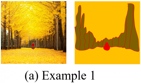
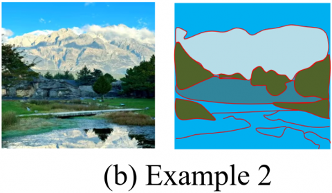
To verify the adaptability of the proposed superpixel segmentation method to different natural resource scenes in tourist attractions, typical images containing vegetation, water bodies, and mountains were selected for the superpixel segmentation effect experiment. As shown in Figure 3, in Example 1, the left side presents a scene of a tourist attraction with golden fallen leaves and trees, while the right side shows the segmentation result, where different colored regions clearly distinguish trees, fallen leaf pathways, and pedestrians, demonstrating the algorithm's ability to precisely capture the texture and color differences in vegetation areas, achieving fine segmentation of vegetation-type resources. In Example 2, the left side depicts a tourist attraction scene combining mountains, water bodies, and vegetation. In the right-side segmentation result, blue areas distinguish different parts of the water body, green areas distinguish vegetation, gray-white areas distinguish mountains, and red boundaries precisely outline the contours of each resource type, showcasing the algorithm’s boundary recognition and type distinction capabilities for multiple natural resources such as water bodies, vegetation, and mountains. In conclusion, the experimental results indicate that the proposed superpixel segmentation method can accurately adapt to typical scenes in tourist attractions, such as densely vegetated areas and mountain-water integrated areas, achieving clear segmentation of different natural resource types through effective integration of color and texture features, thus providing a reliable superpixel unit basis for subsequent real-time monitoring and quantitative evaluation of natural resources.
Figure 3. Image superpixel segmentation examples
Figure 4. Comparison of natural resource superpixel segmentation effects in tourist attractions
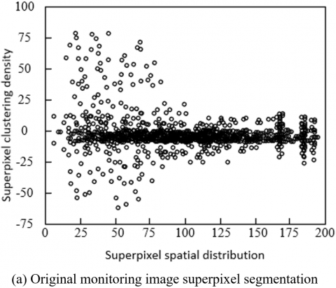
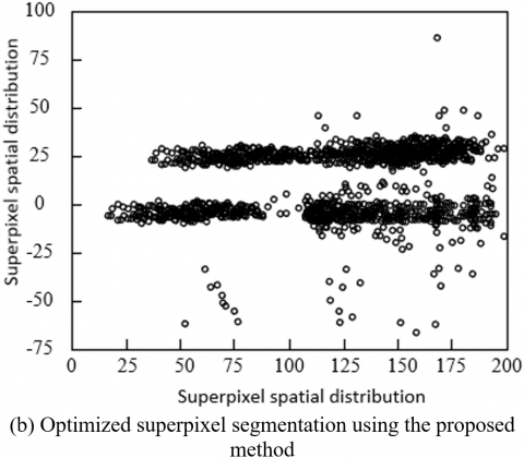
To visually validate the optimization effect of the proposed improved superpixel segmentation method on the boundaries of natural resources and cluster distribution in tourist attractions, a comparison experiment was conducted between the original monitoring image and the optimized segmentation results using the proposed method. As shown in Figure 4(a) represents the superpixel segmentation results of the original monitoring image, where the superpixel clustering density distribution is relatively scattered, indicating that without edge enhancement and noise suppression, the superpixels’ boundary delineation of natural resources such as vegetation and water bodies is blurred, and clustering is severely affected by environmental noise, making it difficult to accurately fit the actual spatial form of resources. On the other hand, (b) shows the segmentation results after optimization by the proposed SE-MMGR-WT algorithm, where superpixel clusters are more concentrated, and boundary distinction is much higher. This is because the structured edge detection enhanced the edge responses of different resource types, and the watershed transformation based on multi-scale morphological gradient reconstruction effectively suppressed environmental noise in the monitoring images while preserving resource texture details, enabling the superpixel segmentation to more accurately match the spatial distribution characteristics of natural resources in tourist attractions. In conclusion, the experimental results intuitively prove the significant advantages of the proposed improved superpixel segmentation method in enhancing resource boundary delineation and optimizing clustering accuracy, providing a high-quality spatial unit foundation for subsequent feature extraction and clustering analysis based on superpixels.
To verify the algorithm’s precise recognition capability for different natural resource types in tourist attractions, a multi-category resource recognition accuracy experiment was conducted, selecting eight typical targets from tourist attractions and performing quantitative analysis using five core classification evaluation metrics. The experimental results shown in Table 1 reveal that the algorithm achieves an average recognition accuracy of 97.6%, an average F1-score of 97.6%, and an average IoU of 95.3%. Among these, the recognition metrics for water resources such as lakes, streams, and artificial landscapes are the highest, benefiting from the fusion of multi-color space features and texture features that effectively capture the color stability of water bodies and the contour regularity of artificial landscapes. The recognition accuracy for primary vegetation types such as coniferous and broad-leaved forests exceeds 97.9%, demonstrating the algorithm’s ability to precisely capture texture differences between different vegetation types through the complementary use of Gabor and LBP texture features. The recognition metrics for exposed rocks and bare land are relatively lower but still exceed 95.8%, primarily due to slight confusion between the textures and color features of weathered rocks and bare land in certain areas, though the algorithm still meets the precise recognition requirements. In conclusion, the experimental results demonstrate that the proposed algorithm effectively distinguishes various natural resources and interference targets in tourist attractions, providing a reliable foundation for subsequent quantitative assessment and detailed management of natural resources.
Table 1. Recognition accuracy for different natural resource types
|
Natural Resource Type |
Accuracy, % |
Precision, % |
Recall, % |
F1-Score, % |
IoU, % |
|
Coniferous Forest |
98.2 |
97.8 |
98.5 |
98.1 |
96.4 |
|
Broad-leaved Forest |
97.9 |
97.5 |
98.3 |
97.9 |
95.9 |
|
Shrubland |
96.5 |
95.8 |
97.2 |
96.5 |
93.2 |
|
Lake |
99.1 |
98.9 |
99.3 |
99.1 |
98.2 |
|
Stream |
98.5 |
98.3 |
98.7 |
98.5 |
97.1 |
|
Exposed Rocks |
95.8 |
95.2 |
96.4 |
95.8 |
92.1 |
|
Bare Land |
96.2 |
95.6 |
96.8 |
96.2 |
92.7 |
|
Artificial Landscape |
99.3 |
99.0 |
99.5 |
99.2 |
98.5 |
|
Average Metrics |
97.6 |
97.1 |
98.1 |
97.6 |
95.3 |
To verify the algorithm’s ability to capture the temporal dynamic changes of natural resources in tourist attractions, continuous monitoring for one year was conducted in the same monitoring area, focusing on the core dynamic indicators of vegetation, water bodies, and bare land, as well as the growth trend of shrubland. The experimental results shown in Table 2 reveal that the algorithm can accurately track the seasonal change patterns of natural resources: vegetation coverage remains above 89% in summer, with an NDVI value of 0.88-0.90, reaching the annual peak, while the water body area increases to 2200-2350 m² due to rainfall, although the water transparency slightly decreases due to algae growth. In winter, vegetation coverage drops to 58.2%, the NDVI value is 0.55, and the water body area decreases to 1600 m² due to drought, while the water transparency increases to 0.92 due to reduced algae under low temperatures. The proportion of bare land exhibits an inverse change pattern, being higher in winter and lower in summer. For the short-term dynamics of shrubland, the algorithm accurately captures the rapid growth period in summer with a monthly growth rate of 8.2%, and the slow decline period in autumn and winter. In conclusion, the experimental results indicate that the proposed algorithm can accurately monitor the temporal changes of natural resources in tourist attractions, effectively extracting core dynamic indicators such as vegetation growth status, water body area, and quality, providing data support for ecological evolution analysis and seasonal protection strategy formulation, fully meeting the goals of real-time monitoring and evaluation.
Table 2. Dynamic monitoring experiment results across time dimensions
|
Monitoring Time |
Vegetation Coverage (%) |
Water Area (m²) |
Vegetation NDVI Value |
Water Transparency Index |
Bare Land Area (%) |
Shrubland Growth Rate (Monthly, %) |
|
Spring (March) |
62.5 |
1850 |
0.62 |
0.85 |
15.2 |
-0.5 |
|
Summer (June) |
89.3 |
2200 |
0.88 |
0.72 |
4.8 |
8.2 |
|
Summer (July) |
90.1 |
2350 |
0.90 |
0.68 |
4.2 |
1.1 |
|
Summer (August) |
89.7 |
2280 |
0.89 |
0.70 |
4.5 |
0.3 |
|
Autumn (October) |
75.4 |
1920 |
0.75 |
0.80 |
9.6 |
-4.3 |
|
Winter (December) |
58.2 |
1600 |
0.55 |
0.92 |
18.5 |
-2.1 |
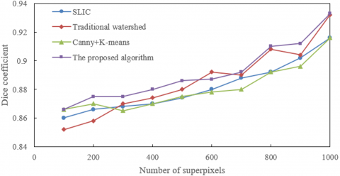
(a) Superpixel segmentation accuracy comparison
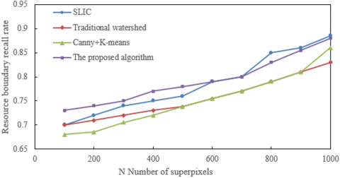
(b) Resource boundary recall rate comparison
(c) Algorithm runtime comparison
Figure 5. Performance comparison of the proposed algorithm with comparison algorithms in the natural resource segmentation task of tourist attractions
To verify the performance advantages of the proposed method in the natural resource segmentation task of tourist attractions, a comparison experiment was conducted with SLIC, traditional watershed, and Canny+K-means algorithms across a superpixel count range from 100 to 1000. The experiment was analyzed from the perspectives of segmentation accuracy, resource boundary recall rate, and runtime. As shown in Figure 5, in terms of superpixel segmentation accuracy, the proposed algorithm performs the best across all superpixel counts, achieving a value of 0.933 when the superpixel count is 1000, significantly higher than SLIC's 0.916, traditional watershed's 0.932, and Canny+K-means's 0.916. This indicates that the collaborative effect of structured edge detection and multi-scale morphological gradient reconstruction enables the algorithm to more accurately distinguish different natural resource types, such as vegetation, water bodies, and bare land, in tourist attractions. In terms of resource boundary recall rate, the proposed algorithm reaches 0.88 when the superpixel count is 1000, outperforming SLIC's 0.885, traditional watershed's 0.83, and Canny+K-means's 0.86, proving its strong robustness in capturing boundaries of vegetation and shorelines, and water bodies and tidal flats. Regarding runtime, the proposed algorithm achieves a runtime of only 0.15s at 1000 superpixels, much lower than SLIC's 0.21s, traditional watershed's 0.295s, and Canny+K-means's 0.25s. This is due to the efficient integration of superpixel preprocessing and FCM clustering, meeting the timeliness requirements for real-time monitoring of tourist attractions. In conclusion, the experimental results fully validate the technical advantages of the proposed superpixel segmentation method in the real-time monitoring and evaluation of natural resources in tourist attractions, in terms of segmentation accuracy, boundary fitting, and computational efficiency.
To verify the robustness of the proposed algorithm in complex lighting environments at tourist attractions, experiments were conducted under four typical lighting conditions: sunny strong light, cloudy weak light, backlight, and shadow occlusion. The experiments analyzed segmentation accuracy, boundary fitting, and runtime efficiency. The results in Table 3 show that the proposed algorithm achieves an average DICE coefficient of 92.4%, an average boundary recall rate of 89.5%, and stable runtime between 0.16s and 0.20s, demonstrating strong robustness. Among these, the cloudy weak light scenario yields the best results with a DICE of 93.2% and boundary recall rate of 90.5%, as the multi-color space features effectively counteract interference from varying light intensities. The backlight scenario shows a slight decrease in performance with a DICE of 91.8% and a boundary recall rate of 88.6%, but it still maintains a high level, reflecting the compensatory role of Gabor texture features in addressing color distortion. In sunny strong light and shadow occlusion scenarios, the performance remains stable, proving the algorithm's good adaptability to local contrast changes caused by strong light and shadow. In conclusion, the experiments show that the proposed algorithm works reliably under various lighting conditions at tourist attractions, meeting the lighting robustness requirements for all-weather real-time monitoring.
Table 3. Robustness experiment results under different lighting conditions
|
Lighting Condition |
DICE Coefficient (%) |
Boundary Recall Rate (%) |
Runtime (s) |
|
Sunny Strong Light |
92.5 |
89.8 |
0.18 |
|
Cloudy Weak Light |
93.2 |
90.5 |
0.16 |
|
Backlight (Water/Veg) |
91.8 |
88.6 |
0.20 |
|
Shadow Occlusion (Under Trees) |
92.1 |
89.2 |
0.17 |
|
Average Level |
92.4 |
89.5 |
0.18 |
To validate the adaptability of the proposed algorithm to various monitoring devices with different resolutions, experiments were conducted with three mainstream resolutions: 720P, 1080P, and 4K. The experiment evaluated segmentation accuracy, runtime efficiency, and resource consumption. As shown in Table 4, with the increase in resolution, the DICE coefficient of the proposed algorithm improves from 91.5% at 720P to 94.8% at 4K, reflecting the gain in segmentation accuracy due to higher resolution providing more detailed information. Both runtime and memory usage increase linearly, with 720P taking 0.12s and 128MB, while 4K takes 0.55s and 512MB. However, the proportion of time spent on superpixel segmentation increases from 35% to 45%, indicating that the algorithm maintains an efficient computational structure even at high resolutions. At 720P, the algorithm already meets basic monitoring requirements, while 1080P and 4K offer more detailed resource characterization. In conclusion, the experiments demonstrate that the proposed algorithm is adaptable to a wide range of monitoring devices in tourist attractions, from standard to high-definition equipment, balancing segmentation accuracy with reasonable computational resource consumption, thus providing flexibility for device selection and deployment in different scenarios.
Table 4. Adaptability experiment results with multi-resolution images
|
Image Resolution |
DICE Coefficient (%) |
Runtime (s) |
Memory Usage (MB) |
Superpixel Segmentation Time Proportion (%) |
|
720P |
91.5 |
0.12 |
128 |
35 |
|
1080P |
93.2 |
0.25 |
256 |
40 |
|
4K |
94.8 |
0.55 |
512 |
45 |
This paper focuses on the core requirements of real-time monitoring and evaluation of natural resources in tourist attractions and proposes a computer vision processing method based on improved superpixel segmentation. The method optimizes superpixel segmentation accuracy through structured edge detection and multi-scale morphological gradient reconstruction watershed transformation. It integrates Gabor and LBP complementary texture features, multi-color space statistical features, and spatial position features to construct high-discrimination vectors, and uses the density peak algorithm to adaptively determine the number of clusters. Finally, the FCM fuzzy clustering algorithm is applied to achieve precise segmentation at the superpixel level. A series of experiments demonstrate that the proposed method significantly outperforms traditional algorithms in terms of segmentation accuracy, resource boundary recall, and real-time algorithm performance. It also exhibits strong robustness and adaptability in different scenarios, including natural resource recognition, temporal dynamic monitoring, complex lighting conditions, and multi-resolution image adaptation. The research value of this method lies in overcoming the precision and efficiency bottlenecks of traditional methods in complex tourist environments. It provides technical support for the precise identification, dynamic tracking, and quantitative evaluation of resources such as vegetation, water bodies, and rocks in tourist attractions, which effectively supports the collaborative management of ecological protection and sustainable tourism development.
Despite its excellent performance in multi-dimensional validation, the proposed method has certain limitations: First, there is a reduction in segmentation accuracy under extreme weather conditions, where image noise and feature ambiguity significantly impact algorithm performance. Second, the integration strategy for multi-modal data has not been fully explored, and the role of multi-source information in enhancing resource monitoring has not been maximized. Third, the optimization for lightweight deployment of the algorithm on edge computing devices is insufficient, making it difficult to directly meet the lightweight requirements for large-scale, real-time monitoring of tourist attractions. Future research can advance in three areas: First, by introducing deep learning components to enhance feature robustness under extreme weather conditions, improving the algorithm's adaptability to harsh environments; second, by exploring multi-sensor data fusion frameworks, integrating infrared, 3D point cloud, and other data to enrich the dimensions and accuracy of resource monitoring; and third, by focusing on algorithm lightweighting and acceleration optimization for edge computing devices, promoting large-scale, real-time deployment of the technology in tourist attractions, and further expanding its application boundaries in smart tourism management and ecological dynamic monitoring.
[1] Li, W.Y. (2021). Coupling and coordinated development of tourism and ecological environment. Journal of Environmental Protection and Ecology, 22(3): 1199-1209.
[2] Sun, Q., Zhang, N.C., Liao, B. (2020). Tourism resources and carrying capacity of scenic tourism areas based on forest ecological environment. Southern Forests: A Journal of Forest Science, 82(1): 10-14. https://doi.org/10.2989/20702620.2020.1733766
[3] Liu, M., Lu, M., Li, Z. (2024). Coupling coordination analysis on digital economy-tourism development-ecological environment. Journal of Cleaner Production, 470: 143320. https://doi.org/10.1016/j.jclepro.2024.143320
[4] Li, M.L. (2021). Dynamic monitoring algorithm of natural resources in scenic spots based on MODIS Remote Sensing technology. Earth Sciences Research Journal, 25(1): 57-64. https://doi.org/10.15446/esrj.v25n1.93869
[5] del Río-Rama, M.D.L. C., Maldonado-Erazo, C.P., Álvarez-García, J., Durán-Sánchez, A. (2020). Cultural and natural resources in tourism Island: Bibliometric mapping. Sustainability, 12(2): 724. https://doi.org/10.3390/su12020724
[6] Mohan, M.M., Baluprithiviraj, K.N., Devi, T.K., Gowtham, K., Prithivaka, P., Kishorrkumar, K.M., Boobesh, S. (2022). Monitoring textile waste water treatment using natural resources. Journal of Pharmaceutical Negative Results, 13: 1575-1578. https://doi.org/10.47750/pnr.2022.13.S03.242
[7] Cundill, G., Fabricius, C. (2010). Monitoring the governance dimension of natural resource co-management. Ecology and Society, 15(1): 15. https://www.jstor.org/stable/26268097.
[8] Bahk, Y.Y., Cho, P.Y., Ahn, S.K., Park, S., et al. (2018). Monitoring of noxious protozoa for management of natural water resources. The Korean journal of parasitology, 56(2): 205-210. https://doi.org/10.3347/kjp.2018.56.2.205
[9] Danielsen, F., Burgess, N.D., Balmford, A., Donald, P. F., et al. (2009). Local participation in natural resource monitoring: A characterization of approaches. Conservation biology, 23(1): 31-42. https://doi.org/10.1111/j.1523-1739.2008.01063.x
[10] Leo, M., Medioni, G., Trivedi, M., Kanade, T., Farinella, G.M. (2017). Computer vision for assistive technologies. Computer Vision and Image Understanding, 154: 1-15. https://doi.org/10.1016/j.cviu.2016.09.001
[11] Ramadoss, J., Venkatesh, J., Joshi, S., Shukla, P.K., Jamal, S.S., Altuwairiqi, M., Tiwari, B. (2021). Computer vision for human-computer interaction using noninvasive technology. Scientific Programming, 2021(1): 3902030. https://doi.org/10.1155/2021/3902030
[12] Zhou, R.G., Liu, D.Q. (2019). Quantum image edge extraction based on improved Sobel operator. International Journal of Theoretical Physics, 58(9): 2969-2985.
[13] İnce, C., İnce, K., Hanbay, D. (2024). Novel image pixel scrambling technique for efficient color image encryption in resource-constrained IoT devices. Multimedia Tools and Applications, 83(29): 72789-72817. https://doi.org/10.1007/s11042-024-18620-2
[14] Li, L., Xie, Y., Liu, Y., Liu, B., et al. (2019). Exploiting optical chaos for color image encryption and secure resource sharing in cloud. IEEE Photonics Journal, 11(3): 1-12. https://doi.org/10.1109/JPHOT.2019.2919576
[15] Sun, M., Li, D. (2021). Smart face identification via improved LBP and HOG features. Internet Technology Letters, 4(3): e229. https://doi.org/10.1002/itl2.229
[16] Wang, X., Du, J., Wu, S., Li, X., Li, F. (2013). Cluster ensemble-based image segmentation. International Journal of Advanced Robotic Systems, 10(7): 297. https://doi.org/10.5772/56769
[17] Yuan, C., Qin, X., Qin, Z., Wang, R. (2018). Image segmentation based on modified superpixel segmentation and spectral clustering. The Journal of Engineering, 2018(16): 1704-1711. https://doi.org/10.1049/joe.2018.8320
[18] Isa, N.A.M., Salamah, S.A., Ngah, U.K. (2009). Adaptive fuzzy moving K-means clustering algorithm for image segmentation. IEEE Transactions on Consumer Electronics, 55(4): 2145-2153. https://doi.org/10.1109/TCE.2009.5373781
[19] Kannan, S.R., Ramathilagam, S., Devi, R., Sathya, A. (2011). Robust kernel FCM in segmentation of breast medical images. Expert Systems with Applications, 38(4): 4382-4389. https://doi.org/10.1016/j.eswa.2010.09.107
[20] Rangayya, Virupakshappa, Patil, N. (2024). Improved face recognition method using SVM-MRF with KTBD based KCM segmentation approach. International Journal of System Assurance Engineering and Management, 15(1): 1-12. https://doi.org/10.1007/s13198-021-01483-3