Tuqa R. Alrobaee![]() | Ahmed S. Al-Khafaji*
| Ahmed S. Al-Khafaji*![]() | Nadia A. Al-salam | Ahmed A. Al-jaberi
| Nadia A. Al-salam | Ahmed A. Al-jaberi![]()
© 2023 IIETA. This article is published by IIETA and is licensed under the CC BY 4.0 license (http://creativecommons.org/licenses/by/4.0/).
OPEN ACCESS
The research deals with the concept of a safe city and the impact of security on cities, in an attempt to identify the most important physical characteristics and indicators necessary to achieve safety in cities. The research identified seven characteristics (access and movement, structure, control, ownership, protection, activity, management and maintenance). From these seven characteristics, eighteen indicators were derived that directly affected the achievement of safety in urban environments. These indicators were applied to the study area, An-Najaf traditional city in Iraq. By adopting the analysis of indicators using field survey, observation and analysis using geographic information systems and mathematical models. The indicators that contributed to achieving a number of characteristics of safe cities in An-Najaf traditional city were identified: the structure of the city, the homogeneity of society, as well as the activity characteristic, as it was characterized by religious and tourism activity.
safer city, traditional city, hierarchy, urban fabric, alley
The concept of a safe city is one of the important concepts in achieving a sustainable city because it aims to provide a healthy and safe environment for the living and movement of all segments of society, especially children and women. This gives the character of vitality and activity to the communities to increase the demand for services and activities in all sectors of land use, and this would enhance the ease of access and physical proximity. The processes of urbanization and the increase in the population within cities contribute significantly to reducing the levels of security within them, through the increase in traffic accidents and the inability to control crime. The government, society, and urban characteristics contribute to providing security and reducing crime, as urban policies and planning methods can help achieve a safer life [1]. The safe city is part of the concept of livable cities and focuses on the problem of crime in urban areas [2]. It is a city that relies on the integration of technology and the natural environment and recommends increasing the effectiveness of healthy places, to reduce crime and achieve readiness and rapid response to emerging threats or emergencies [3]. The safe city strategy also seeks to formulate effective centers with advanced infrastructure that includes sensors, technology, and networks to stimulate sustainable economic growth and high quality of life [4].
Safety is a critical aspect of the quality of life in the city. So the Safer City Program was launched, in 1996 by UN-Habitat at the request of African Heads of State. This program then evolved through three phases. The first phase targeted the urban crime prevention approach, mainly in three areas: institutional crime reduction and violence prevention, social crime prevention, and crime prevention in the physical environment. In the second phase, the program expanded to city safety in two new matters. The first is a security of tenure and forced eviction since property ownership is the cause of conflicts and violence in some countries. The second matter is represented in dealing with natural disasters and efforts to prevent chaos. While the third phase emphasized the use of management and governance, with an emphasis on these phases are linked to each other to formulate a comprehensive approach to safety in the city [3].
The emergence of the concept of defensive space preceded the emergence of the concept of the safe city, as it is a stage of the development of that concept, which depends on the environmental and behavioral psychology of people within places and spaces, which focuses on seven principles represented in regional characteristics, natural control, access control places, mobility destinations, support for legitimate activities, management and visibility of space, and the impact of geographic proximity [2]. Then the safe city concept was developed by adding the social aspect represented by the relationships and community interactions within the places, being one of the basic factors that cannot be ignored. Then it evolved to include the environmental aspect of urban planning and design that suits the human scale by promoting pedestrian-oriented land uses and activities, encouraging places for community interactions, residents' participation in places, community culture, community communication, and identity. Some studies emphasized the community's participation in the neighborhood's self-regulation, recognizing the importance of “eyes on the street” or the community’s eyes for residents who use these spaces [5].
Hong [6] focused on the relationship of communities with the government working to adapt urban environments to be safer places, by reviewing some urban planning projects and infrastructure development in Pakistan. He suggested three ways that could be an entry point in achieving a safe city represented by collecting and producing huge amounts of data about places using technology and communications, establishing advanced and efficient projects that would develop security systems in the city, and imposing control over financial, administrative, legal and control systems in cities [6].
Klanjčić et al. [7] dealt with accidents resulting from urban mobility and contributed to identifying the urban characteristics that would determine the safety of road users. They analyzed urban road accident data for people who died or were seriously injured by collecting data from 24 cities in five European countries. This indicator was adopted as a measure of safety performance in cities, and they concluded that the characteristics of road infrastructure and the intensity of traffic flows have a significant impact on achieving traffic safety for people. They found that cities that rely on high rates of walking and using bicycles and limiting the speed of cars on the streets have less risk of traffic accidents.
Tiboni et al. [1] investigated the role urban planning plays in achieving safer, more climate-friendly mobility. They demonstrated the need for integrated approaches that can combine spatial planning and mobility management, by reviewing several urban policies and urban planning strategies. They presented an urban renewal project in which they showed how pedestrian accessibility increased at the neighborhood level, as this increase came from the effect of two factors: the distribution of services and flexible mobility network patterns, which can contribute to creating a more walkable space.
Al-Jaberi et al. [8] dealt with the possibility of transforming traditional cities into sustainable cities. They chose the city of Karbala in Iraq as a case study, as it includes many characteristics represented by a suitable mixture of land uses, allocating paths for pedestrians only, preventing car entry, homogeneous division of blocks (fine grain), as well as the availability of moderate densities for buildings and residents. These characteristics may enable it to shift towards sustainable cities, and these characteristics enhance security throughout the city.
In their study published in 2020, Lim et al. [9] presented empirical evidence regarding the safe city program launched in Malaysia. They aimed to identify factors contributing to crime prevention by surveying a sample of 400 pedestrians in the business district of Kuala Lumpur. They found that there is a major role for the authorities in enhancing security. However, the measures taken by the community to impose security in the place are less feasible. They recommended that there be an analysis of the behavior of criminals in the selection of appropriate crime sites for them.
Risdiana and Susanto [5] focused on the role of the smart city in achieving a safe city by helping companies and communities control and reduce crime. They presented multiple methods for measuring and evaluating the city's safety, by reviewing a set of indicators, including crime rates in public places and streets, the annual number of victims in the city, health rates, and the availability of health services, as well as other indicators, in an attempt to formulate a measurable conceptual model through which cities security assessment in Indonesia.
From the foregoing, it can be noted that previous studies dealt with the issue of safe cities from different aspects. In this research, we try to link the concept of safe cities with urban planning and urban design, in an attempt to identify effective characteristics and indicators that achieve safe cities in an integrated manner. The research aims to accurately identify the effective characteristics and indicators by supporting them with quantitative and qualitative measurements and setting specific criteria for safe cities. The research assumes that the characteristics of the physical structure have a decisive role in supporting communities in making safe cities.
In this part, the research presents the characteristics of the traditional city as well as the characteristics of the safe city in order to find the common characteristics between them.
2.1 Characteristics of the traditional city
The characteristics of traditional cities can be summarized in four basic characteristics:
2.2 Characteristics and indicators of safe cities
Safe cities are characterized by some characteristics and indicators that characterize their urban structure, and have a fundamental role in preventing crime:
From the foregoing, indicators of access and movement characteristic can be:
- Connectivity
- Measures to slow down the movement of vehicles
- Diversity in transportation modes.
From the foregoing, indicators of Structure characteristic can be:
-The presence of a percentage of cul-de-sacs in the residential neighborhood, they are short and straight.
-Choosing the right locations for the open spaces and that they are surrounded by buildings.
From the foregoing, indicators of Surveillance characteristic can be:
-Provide a visual connection between the buildings on the one hand and the squares and streets on the other.
-Designing residential units to ensure that kitchens and living rooms overlook car parks, streets, and public areas.
-The ability of managers and guards to monitor public places.
Underpinning the ownership is a clear distinction between public, semi-private/shared, and private space [17]. From the foregoing, indicators of Ownership characteristic can be:
-Ownership of housing units or lands and property in general.
-Empowering members of the community, and providing services to meet the needs of the community.
-The existence of a clear distinction between the boundaries of ownership (public, semi-private or joint, private)
From the foregoing, indicators of this characteristic can be:
-The presence of doors, fences, and walls in their appropriate places.
-The ability of the barriers to be visually penetrated is subject to observation.
Also, providing a range of housing types in terms of size, type, ownership, and the family's ability to bear its costs can lead to attracting a people mixture of different ages, lifestyles, and economic statuses thus providing a kind of good activity [24].
From the foregoing, the indicators of Activity characteristic can be:
-The mixed land uses
-The mix of housing types
-The pedestrians' density provides the vitality of the place.
The system must have a high level of cleaning and maintenance, whether it is implemented by public, private, or voluntary organizations, through which a strong message can be sent about zero tolerance for vandalism [15].
Table 1. Characteristics and indicators of safe cities
|
Characteristics |
Indicators |
Methods |
Standards |
|
Access and movement |
Connectivity |
R/A |
≥ 1 |
|
Measures to slow down the movement of vehicles |
Field survey |
The presence of physical partitions to ease the movement of vehicles |
|
|
Diversity in transportation modes |
(A+B) > (C+D) |
50 < (A + B) |
|
|
Structure |
percentage of cul-de-sac |
Field survey |
The presence of a percentage of the cul-de-sac in the residential neighborhood, and they are short and straight. |
|
Space design |
Field survey |
Designing the correct places for open spaces, and to be surrounded by buildings and provided with a supporting intention. |
|
|
Surveillance |
visual connection |
Field survey |
Provide a visual connection between the buildings on the one hand and the squares and streets on the other Provide a visual connection between the buildings on the one hand and the squares and streets on the other. |
|
Designing residential units |
plans |
The units have windows overlooking the street for the living and kitchen spaces. |
|
|
Security personnel monitoring |
Field survey |
The number of security personnel responsible for monitoring and regulating places and people using them |
|
|
Ownership |
Ownership of housing units and lands |
questionnaire form |
The number of people who own lands, units, and buildings |
|
Ownership boundaries |
Field survey |
Physical boundaries separating the properties (public, semi-private or joint, private) |
|
|
empowerment and service provision |
500m access distance |
Users access services within a distance of 500 meters |
|
|
protection |
doors and fences |
descriptive criterion |
Provide doors and fences to protect and prevent penetration |
|
A visual penetration of barriers |
descriptive criterion |
Allow vision and visual control through fences and fences |
|
|
activity |
mix land use |
entropy index |
0-1 |
|
Diversity of housing types |
Simpson Index |
0-1 |
|
|
pedestrians' density |
P/A |
P/H 500 The number of people passing by and owners of shops and uses |
|
|
Administration and maintenance |
Entities responsible for the management |
descriptive criterion |
Governmental or private agencies working to manage places |
|
Coordination and cleaning |
descriptive criterion |
Waste collection, coordination, and trimming of trees and plants |
From the foregoing, the indicators of Management and Maintenance characteristic can be:
-The presence of governmental or private agencies concerned with cleaning and maintenance.
-Coordination and periodic cleaning to cut grass, clean trees, preserve public places, and continuous removal of rubbish and dirt.
Table 1 shows the characteristics and indicators of safe cities and the methods of measurement in comparison with the standard.
The research dealt with the concept of a safe city by reviewing a number of recent literature that focused on important aspects of the subject. After that, the research looked at the characteristics of traditional cities, as well as the characteristics of safe cities, to find similarities between their characteristics, to determine the critical indicators of safe cities, which are influential in the development of traditional cities.
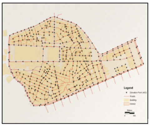
After studying and analyzing many previous recent studies that dealt with safer cities, the knowledge gap was identified, the problem was presented and the goal was set, and the research reached through its approved hypothesis that many features and indicators were relied upon in the analysis of the study area. The descriptive analytical approach was adopted by collecting data from the relevant departments and institutions in the province of An-Najaf such as (the Directorate of Urban Planning, Directorate of Municipality, and Administration of the Shrine of Imam Ali bin Abi Talib), as it has relied on many descriptive indicators that could be applied in the study area, and it was Analyze it based on observation and field monitoring of the situation. In addition to many quantitative indicators that can be analyzed using mathematical models and the database of statistical tables and maps of geographic information systems, to accurately represent the reality of the situation, the extracted results were compared with the standards adopted in safe cities. Figure 1 shows the proposed methodology.
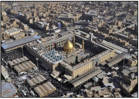
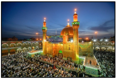
An-Najaf traditional city characteristics that enable it to be a safe city. The city is characterized by a compact structure, the fence that surrounds it, street planning, and a mixture of uses, as well as the social characteristics emanating from the spirit of the place and its religious nature, as it includes the shrine of the fourth caliph for the Muslims, Ali Ibn Abi Talib. The importance of this city made there a great government interest in terms of management, organization, and imposing security in the place [26].
Figure 1. Methodology of research
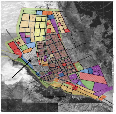
Figure 2. Location of An-Najaf traditional city concerning the master plan
The emergence of the city is due to spiritual factors through its inclusion of the shrine of Imam Ali bin Abi Talib, which is distinguished by the fact that it arose at the highest plateau and no river passes through it, and it is bordered by the western side by the An-Najaf Sea as a natural threshold, in addition to the Wadi Al-Salam cemetery [27], which is considered one of the largest cemeteries in the world as a human threshold It is hoped that it will be added to the World Heritage List, which greatly contributed to making the city take specific directions in its urban growth outside the traditional city, which includes the historical center [10]. See Figure 2 shows the location of An-Najaf traditional city concerning the master plan of the city.
5.1 Access and movement character
Figure 3. The nodes and linkages of the in An-Najaf traditional city
Figure 4. The movement of buses and private cars in An-Najaf traditional city border
Figure 5. The movement of the pedestrian cars in An-Najaf traditional city
5.2 Structure character
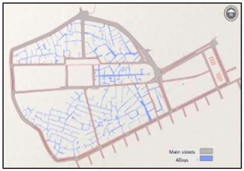
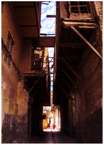
Figure 6. The cul de sac alleies and main streets in An-Najaf tradional city
Figure 7. Al-Huwaish neighborhood center (Fadua)
5.3 Surveillance character
Figure 8. Surveillance and visual connection of commercial buildings on Zainalbdeen street
Figure 9. Building design cars in An-Najaf traditional city
Figure 10. The central place of the holy shrine and its centrality cars in An-Najaf traditional city
5.4 Ownership character
Figure 11. Ownership type in An-Najaf traditional city
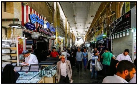
Figure 12. Commercial services in An-Najaf traditional city
5.5 Protection character
The city is considered one of the walled cities, as the wall was built for defensive purposes many years ago, but this wall has destroyed several parts of it at present. In general, all residential units and buildings are surrounded by walls that give them privacy and distinguish them from other properties, which makes it easier to control and monitor them and limits the entry of strangers to them.
5.6 Activity character
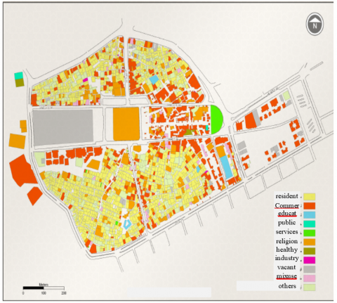
Figure 13. Land use and distribution of services in An-Najaf traditional city
Figure 14. Diversity of housing types in An-Najaf traditional city
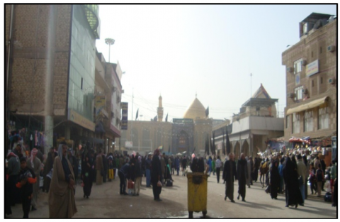
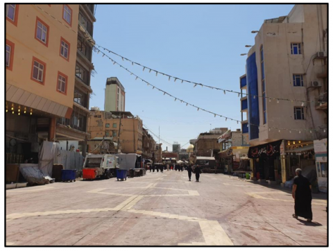
It is one of the religious tourist cities, therefore visitors flock to it from all over the world, especially Islamic countries, and for this reason, its streets are most of the time occupied by the population, as their density reached 950 people per hectare. This contributes to imposing greater restrictions on criminals due to the lack of vacant places where criminals usually resort to committing their crimes. See Figure 15.
5.7 Administration and maintenance character
Table 2 shows the result of the analysis of proposed indicators for the characteristics in An-Najaf traditional city.
Table 2. Result of the analysis of the indicator for the traditional city of Najaf
|
Characteristics |
Indicators |
Result |
Discussion |
|
Access and movement |
Connectivity |
2.2 |
The blocks are short in size which makes the connectivity and accessibility very high in the city. |
|
Measures to slow down the movement of vehicles |
)A+B) = 100% |
The rate of movement of pedestrians and biking is 100%, while the movement of private and public vehicles is non-existent within the city. |
|
|
Diversity in transportation modes |
not achieved |
The city is for pedestrian traffic only, so there are no measures to slow down the movement within it, and it is only on the main streets. |
|
|
Structure |
percentage of cul-de-sac |
achieved to a large extent |
The neighborhoods include a large number of alleys with closed ends because they are intended for the movement of pedestrians only, as they are narrow and tortuous. |
|
Space design |
achieved to a small extent |
Spaces in the city are few and relatively small, due to the city's compact structure. |
|
|
Surveillance |
visual connection |
achieved to a large extent |
The streets are monitored most hours of the day and even late at night, in addition to most public and private squares due to the city's tourism activity and the presence of shops that are usually open. |
|
Designing residential units |
achieved to a large extent |
The residential units were designed to have wooden windows overlooking the street on the upper floors to control and monitor the alleys and spaces, as well as climatic characteristics to take advantage of the air movement in the alleys. |
|
|
Security personnel monitoring |
achieved to a large extent |
In the main central space, there are a large number of security and administrative personnel to regulate the movement of visitors. |
|
|
Ownership |
Ownership of housing units and lands |
achieved to a large extent |
The largest percentage is privately owned by the city's residents, which achieved the largest percentage, reaching 76%, so monitoring, control, and interest are greater. |
|
Ownership boundaries |
achieved to a large extent |
Ownership of endowments and the municipality is concentrated in the central area, as it constitutes places of public use. The boundaries of the housing units are private property. |
|
|
empowerment and service provision |
A distance of 500 meters, achieved for all uses |
The access for residents and visitors to all kinds of residential, commercial, religious, recreational, educational, and health uses, as well as the use of light industries and heritage industries. |
|
|
protection |
doors and fences |
achieved to a large extent |
All residential units and buildings are surrounded by walls that give them privacy and distinguish them from other properties, which makes it easier to control and monitor them. |
|
A visual penetration of barriers |
not achieved |
This indicator achieves low values because the social and religious character of the city's population does not allow visual penetration |
|
|
activity |
mix land use |
It has a value of 0.68 which is a good value |
Residential use occupies the largest proportion and is spread throughout the city. Commercial use is spread along the main and secondary streets. Recreational and religious uses occupy the central area. |
|
Diversity of housing types |
Its value was 0.1, which is a very low |
Most of the housing units in the traditional city of Najaf are of the horizontal type, so this indicator achieves a low value. |
|
|
pedestrians' density |
950 people/ hectare |
The tourist nature of the city made the rate of pedestrian density high, as its streets are most of the time occupied by the population, which makes it difficult to provide a suitable environment for criminals due to the high surveillance. |
|
|
Administration and maintenance |
Entities responsible for the management |
achieved to a large extent |
The interest of the local and central government is available since the city represents a religious center, religious institutions and schools, and a place that includes many cultural and religious symbols. Therefore, government agencies take management upon themselves. |
|
Coordination and cleaning |
achieved to a moderate extent |
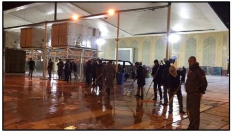
The accumulation of waste in large quantities, especially in the seasons of religious celebrations, constitutes an additional burden on the municipality. Despite this, the municipality continues to collect waste, clean the streets and cut trees throughout the day. |
Figure 15. The visitor density in the religious events types in An-Najaf traditional city
Figure 16. Works of cleaning after the celebrities
The concept of safe cities is one of the important concepts that contribute to achieving sustainability, as this concept is achieved through cities that are characterized by good physical structures, that would support the mix of uses, provision of services, safe housing, and provide easy access and physical proximity to communities.
Homogenous societies can be more secure by imposing surveillance on public and open spaces and limiting the entry and penetration of strangers, which would increase the chances of crime. Homogenous communities also increase the possibility of interaction and the formation of social relationships, which would make a safer city.
Cities that support the multiplicity and diversity of activities, such as containing commercial, recreational, religious, and tourism activities that attract residents and achieve a suitable vitality for places, thus achieving safety in places by monitoring and occupying them most of the time of the day, which reduces the chances of providing empty places that encourage crime.
Great interest in planning public and open spaces, streets, and squares because of their great importance in determining the level of safety in cities, as they reflect the extent of interaction and social relations and express the extent of activity and vitality of urban communities and the achievement of safety.
The article recommends studying the relationship between safe places and increasing the productive efficiency of societies. It is also possible to study the relationship between safe cities and physical health, as well as the possibility of studying the relationship between safe cities and multi-use cities.
[1] Tiboni, M., Rossetti, S., Vetturi, D., Torrisi, V., Botticini, F., Schaefer, M.D. (2021). Urban policies and planning approaches for a safer and climate friendlier mobility in cities: Strategies, initiatives and some analysis. Sustainability, 13(4): 1778. https://doi.org/10.3390/su13041778
[2] Anuar, A.N.A., Bookhari, S.N., Aziz, N.A. (2012). The effectiveness of Safe City Programme as safety basic in tourism industry: Case Study in Putrajaya. Procedia-Social and Behavioral Sciences, 42: 477-485. https://doi.org/10.1016/j.sbspro.2012.04.213
[3] Lacinák, M., Ristvej, J. (2017). Smart city, safety and security. Procedia Engineering, 192: 522-527. https://doi.org/10.1016/j.proeng.2017.06.090
[4] Yigitcanlar, T., Kamruzzaman, M., Foth, M., Sabatini-Marques, J., da Costa, E., Ioppolo, G. (2019). Can cities become smart without being sustainable? A systematic review of the literature. Sustainable Cities and Society, 45: 348-365. https://doi.org/10.1016/j.scs.2018.11.033
[5] Risdiana, D.M., Susanto, T.D. (2019). The safe city: Conceptual model development-A systematic literature review. Procedia Computer Science, 161: 291-299. https://doi.org/10.1016/j.procs.2019.11.126
[6] Hong, C. (2022). “Safe cities” in Pakistan: Knowledge infrastructures, urban planning, and the security state. Antipode, 54(5): 1476-1496. https://doi.org/10.1016/j.procs.2019.11.126
[7] Klanjčić, M., Gauvin, L., Tizzoni, M., Szell, M. (2022). Identifying urban features for vulnerable road user safety in Europe. EPJ Data Science, 11(1): 1-15. https://doi.org/10.1140/epjds/s13688-022-00339-5
[8] Al-Jaberi, A.A., Al Al-Khafaji, A.S., Al-Salam, N.A., Alrobaee, T.R. (2021). The crossing as a new approach for the urban transformation of traditional cities towards the sustainability. International Journal of Sustainable Development and Planning, 16(6): 1049-1059. https://doi.org/10.18280/ijsdp.160606
[9] Lim, S.B., Yong, C.K., Malek, J.A., Jali, M.F.M., Awang, A.H., Tahir, Z. (2020). Effectiveness of fear and crime prevention strategy for sustainability of safe city. Sustainability, 12(24): 10593. https://doi.org/10.3390/su122410593
[10] Al-Shouk, N.D., Al-Khfaji, A.S. (2018). Toward sustainable compact city: (Study in convert traditional Najaf city to sustainable compact city). KnE Engineering, 3(4): 167-192. https://doi.org/10.18502/keg.v3i4.2168
[11] Al-Khafaji, A.S.J., Al-Salam, N.A.M. (2018). Measurement of urban sprawl and compactness characteristics Nasiriyah city - Iraq as case study. International Journal of Civil Engineering and Technology (IJCIET), 9(9): 335-343.
[12] Al-Mosawy, S.K.A., Al-Jawari, S.M., Al-Jaberi, A.A. (2020). The effect of urban form on temperature for hot arid zones. The case study of Baghdad, Iraq. IOP Conference Series: Earth and Environmental Science, 459: 062109. https://doi.org/10.1088/1755-1315/459/6/062109
[13] Amany, A.K., Ebraheem, M.A. (2020). Comparative Analysis of land use and urban growth modeling using geomatics technology (city of Najaf-Iraq). IOP Conference Series: Materials Science and Engineering, 881(1): 012023. https://doi.org/10.1088/1757-899X/881/1/012023
[14] Alnaim, M.M. (2020). The hierarchical order of spaces in Arab traditional towns: The case of Najd, Saudi Arabia. World Journal of Engineering and Technology, 8(3): 347-366. https://doi.org/10.4236/wjet.2020.83027
[15] Llewelyn-Davies, Partnership, H.M. (2004). Safer Places: The Planning System and Crime Prevention: Thomas Telford.
[16] Kenworthy, J. (2014). Trends in low carbon transport and urban development in 33 cities, 1995/1996 to 2005/2006: Some prospects for lower carbon transport Low carbon cities. Routledge, pp. 151-168. https://doi.org/10.4324/9781315766003
[17] Cozens, P. (2013). Crime prevention through environmental design Environmental Criminology and Crime Analysis, Willan, pp. 175-199.
[18] Mappaselleng, N.F., Ahmad, A.K., Sutiawati, Z.K.K. (2019). Prevention among housing residents: The utility of collective efficacy as crime informal social control in the city of Makassar. Journal of Critical Reviews, 7(1): 2020. http://dx.doi.org/10.31838/jcr.07.01.58
[19] Nuttin Jr, J.M. (1987). Affective consequences of mere ownership: The name letter effect in twelve European languages. European Journal of Social Psychology, 17(4): 381-402. https://doi.org/10.1002/ejsp.2420170402
[20] Salazar, B.P. (2011). Building urban safety through urban planning and management: Conclusions and recommendations for future policy Building Urban Safety Through Slum Upgrading: United Nations Settlement Programme (UN-HABITAT).
[21] Faraji, A., Farkhondeh, A. (2021). A framework of urban furniture design for crime reduction. Paper presented at the Conference: 8th International Conference on Mechanics, Construction, Industry and Civil Engineering, mmiconfAt: Istanbul-Turkey.
[22] Banerji, H., Ekka, A.A. (2016). Designing safer cities-review of environmental crime prevention strategies. GSTF Journal of Engineering Technology, 3(4): 25-32. https://doi.org/10.5176/2251-3701_3.4.156
[23] Wo, J.C. (2019). Mixed land use and neighborhood crime. Social Science Research, 78: 170-186. https://doi.org/10.1016/j.ssresearch.2018.12.010
[24] Townsley, M., Reid, S., Reynald, D., Rynne, J., Hutchins, B. (2014). Risky facilities: Analysis of crime concentration in high-rise buildings. Trends and Issues in Crime and Criminal Justice, (476): 1-7.
[25] Kitchen, T. (2009). Crime prevention, the planning system and sustainable development. Built Environment, 35(3): 328-345. https://doi.org/10.2148/benv.35.3.328
[26] Alrobaee, T.R. (2021). Measuring spatial justice indices in the traditional Islamic cities by using GIS, An-Najaf Holy City, Iraq a case study. Journal of Geoinformatics & Environmental Research, 1(2): 59-69. https://doi.org/10.38094/jgier1220
[27] Al-Jaberi, A., Al-Khafaji, A., Ivankina, N., Al-Sawafi, M. (2019). The idea of pedestrian pockets as a key for successful transit-oriented development for Najaf city-Republic of Iraq. IOP Conference Series: Materials Science and Engineering, 698(3): 033029. https://doi.org/10.1088/1757-899X/698/3/033029
[28] Data of the Directorate of Physical Planning in Najaf Governorate.
[29] Dewan. (2011). Dewan architects and engineers. Urban renewal of the city center of holy Najaf. Ministry of Municipalities and Public Works.