Attipo Reisch Vanel*![]() | Emvoulou Joachim Innocent
| Emvoulou Joachim Innocent![]() | Aholou Cyprien Coffi
| Aholou Cyprien Coffi![]()
© 2023 IIETA. This article is published by IIETA and is licensed under the CC BY 4.0 license (http://creativecommons.org/licenses/by/4.0/).
OPEN ACCESS
This manuscript analyses the cascading effects between urban technical networks in Brazzaville, Congo. To this end, we have identified the urban networks that are essential to the functioning of the city, namely the road network, the drinking water network, the sanitation network and the electricity network. The working methodology is based on a spatial analysis of flooding and an analysis of vulnerability using indicators of exposure (direct contact with water), sensitivity (malfunctions caused when in contact with water) and adaptability (continuity of operation once in contact with water) of the urban technical networks. The analyses show that all the technical urban networks appear to be dependent or interdependent on each other. The road network is the most exposed, but causes very little disruption to the others, while the electricity network is the one that causes the most disruption once it malfunctions. The cascading effects between urban technical networks stem from functional, physical or cybernetic dependency and can cause partial or total failure of the affected network. A power failure could extend functional vulnerability to the drinking water supply network via pumps, which depend on electricity. This research is being carried out in the context of urban risk management, with the aim of ensuring urban resilience to flooding.
cascading effects, Brazzaville, flooding, urban networks, vulnerability
Cities, regions and their inhabitants are becoming increasingly dependent on technical urban networks, requiring them to be available and functional at all times. Moreover, although these networks are efficient and robust in their day-to-day management, they are vulnerable to major hazards [1] and dependent on one another [2]. The drinking water supply network in urban areas, road signs, rainwater retention basin pumps and the telecoms system all depend on the electricity network. The increase in risks relating to the operation of these networks is linked in particular to urbanisation, ageing infrastructures, the reduction in State control and the multiplication of players due to liberalisation and privatisation, but also to the increased use of information technology, the increase in interconnections and links between stakeholders and systems, and the ongoing quest for efficiency and profitability. We are also witnessing an increase in the number of threats, from natural hazards, particularly as a result of current climate change [3].
Networks are therefore made up of lines: sections of pipes, cables and roads, as well as production centers (drinking water production plant, power station), transfer or storage centers (reservoirs, electrical transformers, pressure-reducing stations) and consumption centers (customers, consumers, users). This arborescent vision is relevant for distribution networks, but another vision of networks recommends linking all the points in the city as exhaustively as possible [3]. This vision corresponds more to transport or information networks in which all the points are both transmitters and receivers. It should be noted that sewage or waste networks, for example, can also be described as inverted tree networks: the producers are the users and the flows converge towards the consumption site: the treatment plant. However, this distribution-connection distinction is becoming less and less relevant due to recent developments in networked systems [4].
These networks, and their infrastructures, can be dependent or interdependent [2]. A dependency between two systems is expressed by the ability of one system to influence the state of the other, whereas an interdependency arises when the dependency relationship is bidirectional, and the state of each infrastructure influences the state of the other. These dependencies can then lead to the propagation of failures from one system to others, resulting in progressively worse consequences, as well as an increase in the area affected and the duration of the disruption.
In Brazzaville, with its equatorial climate, it rains 6 out of 12 months of the year, and at least five (5) of the city's nine (9) arrondissements (Mfilou, Djiri, Talangai, Ouenzé, Kintele...) are subject to heavy flooding during several seasons. The vulnerability of urban sites to flooding means that urban roads are impassable for several hours or even days. This dysfunction of the road network disrupts emergency services, access to basic services, the waste collection system and repairs to other networks such as telecom network controls. There are also power cuts during floods, which impact access to drinking water in Brazzaville.
1.1 The criticality of technical urban networks
The vulnerability of technical networks to flooding does not entirely justify focusing on these networks. Indeed, if the impacts caused by the degradation of technical networks were low, the high vulnerability of these infrastructures would be of very relative importance. However, the vulnerability of these technical networks is problematic precisely because the impacts associated with network degradation are significant [5]. As a result, these infrastructures are now commonly referred to as "critical infrastructures" [6, 7]. These issues are not entirely new. Critical infrastructures have long been recognised as a major source of vulnerability for populations [8]. It is therefore "common sense" to keep emergency services out of flood-prone areas. However, experience shows that the dependence of populations (and society in general) on these infrastructures seems to be increasing [9, 10]. What's more, these infrastructures are themselves becoming increasingly interdependent, leading to increasingly uncontrollable chain effects [9, 10].
Two characteristics confirm that technical networks are indeed critical infrastructures. Firstly, the impact of network malfunctions is considerable. For example, various electricity networks around the world have experienced major disruptions in recent years, leading to blackouts. Secondly, these infrastructures are complex systems [8]. As a result, it is difficult to assess the impact of malfunctions. Indeed, the effects induced by these malfunctions are of such different natures that the assessment of the economic spin-offs of these events is imprecise.
Lastly, studies of critical infrastructures are particularly interesting when they deal with issues of interdependence between infrastructures, since these infrastructures are considered critical mainly because they are interdependent. Indeed, the failure of one critical infrastructure can (and often will, since its impacts are significant) lead to the failure of another critical infrastructure, resulting in chain failures through cascading effects [11, 12]. To speak of interdependent critical infrastructures is therefore a pleonasm. The consequences of the failure of a critical infrastructure go far beyond the failure of the infrastructure itself. Like critical infrastructures, technical networks are interdependent [13].
1.2 Cascading effects and urban networks
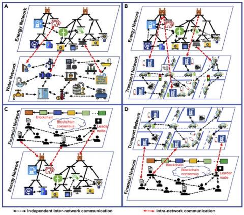
Cascading failures within a network are initiated when a heavily loaded node is lost for any reason, and the load on that node (i.e., the flow through it) has to be redistributed to the other nodes in the network. This redistribution can cause other nodes to exceed their capacity, causing them to fail as well. Protection mechanisms built into the network can also cause outages [14]. As a result, the number of failed or stressed nodes increases, spreading throughout the network [15]. These cascading phenomena tend to highlight unidentified or unresolved vulnerabilities in the company, and increase the consequences of a hazard when it occurs. But they also make recovery and reconstruction processes much slower and more difficult [13], which raises systemic and resilience-related issues (Figure 1).
Finally, (inter) dependencies and the cascading failures that result from them prove to be risk "multipliers" [16]. Indeed, they extend the vulnerabilities of critical infrastructures and the networks of which they are part, they generate cascading consequences such as cascading failures, and they broaden the requirements necessary for system resilience. A consistent study of cascading failure events observed throughout the world has enabled us to assess the representativeness of different sectors (services, networks, activities, etc.) among cascade initiating events or events resulting from cascading. Some networks appear to be more "aggressive" than others, i.e., their disruption has a greater impact on other networks. In addition, various empirical studies [17, 18] suggest that few sectors are ultimately responsible for serious multi-sector failure sequences.
In 2012, during the Sandy floods in New York, Hurricane Sandy hit the United States in October 2012, affecting the coasts of New Jersey and New York in particular. This region is one of the most densely populated in the United States, concentrating many infrastructures and issues essential to the functioning of the country [19]. We can cite the cascading chains on buildings, on the economic sector, on the sewage network and on telecommunications networks [20]. The complexity of the disaster and its many forms is reflected in the number of victims, with the hurricane directly causing the death of 72 people in the United States, and indirectly causing the death of 87 others, including 50 apparently linked to the combined effect of prolonged power cuts and very low temperatures.
Although complex, we understand that urban technical networks are essential to the functioning of a city. Thus, this manuscript will analyze the vulnerability of urban networks to flooding and then dissect the cascading effects generated by the interdependent relationship between these different urban technical networks in Brazzaville.
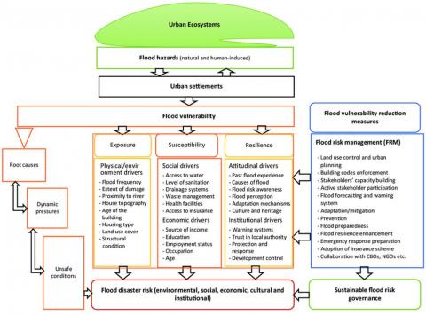
Although vulnerability assessment was initially limited to an evaluation of the degree of damage caused by a given hazard [21] since 1980 it has been enriched by the three concepts of exposure, sensitivity of issues and adaptive capacity [21, 22]. For Meesner and Meyne [23], in the context of assessing vulnerability to flooding, the concept of exposure is made up of two indicators. This study will examine this age-old approach, which is described using four modules: hazard, exposure, vulnerability and consequences. Exposure, vulnerability and consequences [24] to calculate the risks between urban networks first and then analyse the cascading effects between these networks.
It should be noted that exposure refers to the nature and degree to which a network is exposed to flooding over a certain period of time; as an indicator we can refer to the network's direct contact with water during a flood and the duration of this contact. Sensitivity is the propensity of a network to suffer damage in the event of flooding; the number of damages or functional malfunctions will be used as indicators. Finally, adaptability here is used as the ability of a network to continue to function during flooding even if it is affected. continuity of service is a good indicator for analysis (Figures 2 and 3).
Figure 2. Vulnerability analysis diagram [25]
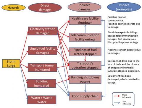
Figure 3. Modelling the impact of disasters on urban networks
Diagnostic methods at component level have the advantage of formalising multiple types of knowledge in a reproducible and therefore comparable form. Territorial diagnostic methods, on the other hand, enable the complexity of a system to be analysed by linking descriptive indicators. What's more, the collaborative dimension of these analyses makes it easier to identify data that would otherwise be difficult to obtain and articulate. The idea is to reduce complexity by first analysing different aspects of the problem separately, using the same analytical grid (component diagnosis). Systemic tools are then used to analyse the system as a whole (territorial diagnosis). The point of diagnosis is to combine information from different fields of expertise in order to provide a model of reality.
The diagnosis of the operation of urban technical networks proposed in this article makes it possible both to assess the consequences of a disruption on the service provided (vulnerability diagnosis) and to identify the causes of a possible service malfunction. It also includes criteria for assessing resilience, such as autonomy, operation in degraded mode and recovery. In this way, the diagnostic tool makes it possible to identify and organise a number of variables, particularly in terms of time, which can be used to refine the analysis of system operation. A spatial analysis using GIS will enable urban networks to be modelled before vulnerability is assessed. Cascading effects will be assessed using a systemic analysis of interdependence and propagation of vulnerability. This will be done using an ad doc model. So, we used both Arcgis 10.8 and Qgis 3.16 for an analysis of the urbanisation of networks, a spatial analysis of floods and an overlay between networks and floods.
• Direct and indirect impacts
To clarify the direct and indirect effects, we'll use the fictitious example of water. Based on the literature, two impact measures are employed to evaluate indirect effects: The population that loses service and the size of the network that is affected are also factors. The first measure can easily be converted into economic costs when replacement/repair prices per unit length are provided, whereas the second measure is more adapted to indicate non-financial social costs [26].
The parameters of the water supply system are the length of potentially polluted pipework and the population equivalent not served. The inhabitant equivalent is the difference between a person's individual daily needs and their total daily needs. In towns of average size, the individual demand for the layout of the water delivery system in Italy is governed by standards and equals about 200 litres per person per day. The inhabitant equivalent is equal to the number of people who exclusively use domestic water.
3.1 Study area
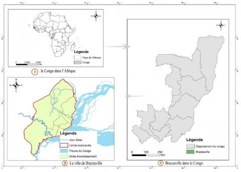
Brazzaville is the political capital of the Republic of Congo, and the country's largest urban area. It is located on the right bank of the river Congo. Brazzaville is divided administratively into 09 arrondissements: Makélékélé, Bacongo, Poto-poto, Ouenzé, Talangai, Madibou, Moungali, Mfilou and Djiri. A city with many functions, Brazzaville attracts many new residents every year. It is located in the Pool department. It is bordered to the north and south by the Pool department, to the east by the Congo River and to the west by the Pool department. The geographical coordinates of Brazzaville in degrees and minutes are: latitude 4°16.014' south, longitude 15°16.9962' east. It currently covers an area of 263.9 km2, with a population of 1,696,392 [27], giving a density of 5,204 inhabitants per km2. This impressive urban growth has its origins in the rural exodus [28]. Population growth also has an impact on the environment (Figures 4 and 5).
Figure 4. Map of Brazzaville
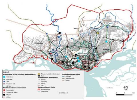
Figure 5. Map of key urban technical networks in Brazzaville
Brazzaville’s hydrographic network is entirely included in the Congo River basin and is made up of rivers that cross the city from west to east, the most important of which are: the Djiri, the Kélékélé, the Tsiémé, the Madoukou, the M’foa, the M’filou, the Djoué and the Loua. The Djiri in the north, with an average flow of 300 m3/second, and the Djoué in the south, with a flow of almost 500 m3/second, are the most important rivers. On the other hand, the Tsiémé in the centre, which crosses five (05) districts, is the largest catchment area, covering 6,370 ha [29].
3.2 Urban networks in Brazzaville
A network (which we will call technical) is: - a structure, with lines (cable, pipe, track, etc.) and nodes, which may be production, transformation or storage centres, each of varying importance for the overall operation of the network; - flows, subject to fluctuations in production/transfer/consumption: electricity, water, waste, vehicles, information, etc. personnel, needed to manage, monitor, maintain and repair the various installations" [30]. The network then appears as a socio-technical system, and we can artificially separate the organisational layer from the technical layer (structure, flows, connections).
The "technical network" system is managed by an organisation interacting with its ecosystem. On the other hand, the spatially localised sub-parts that make up this network will have localised technical dependencies that differ from the previous ones. Modelling technical interactions (an operational constraint) between networks therefore involves thinking about 'breaking down' the network into smaller elements. This research focuses on five essential and critical urban networks (road, drinking water, sanitation, telephone and electricity) in the city of Brazzaville, which are made up of lines: sections of pipes, cables and roads, as well as production centers (drinking water production plant, power station), transfer or storage centers (reservoirs, electricity transformers) and consumption centers (customers, consumers, users). Table 1 below gives a description of the length of these different urban networks.
Table 1. Brazzaville's urban networks
|
Networts |
Linear in Km |
|
Road |
363 |
|
Drinking water |
1042, 5 |
|
Sanitation |
135 |
|
Electrical |
13000 |
|
Télécom |
100 |
The urbanisation of the networks has not kept pace with that of the city. For example, Brazzaville's rainwater drainage network is based on urban watercourses, which act as natural collectors (drainage basins covering an area of 12,510 ha, with a total length of 41.5 km), and the various structures (collectors, outfalls, gutters), totalling 135,740 km, all converging on the Congo River and its tributaries. Most of the rainwater drainage systems are made up of gutters built along the roads, which, like the waterways, are clogged with all kinds of rubbish. They are very poorly maintained and are overloaded when it rains. In addition to the difficulty of building a reliable rainwater drainage network due to lack of space, there is also a lack of solid waste management structures, leading people to turn the riverbeds and existing sewage works into dumping grounds. It is precisely this blockage of the network that causes flooding in the lower parts of the city.
3.3 Flood vulnerability analysis
Strictly speaking, network vulnerability is characterized by downstream and internal vulnerability. External vulnerability, on the other hand, reflects society's vulnerability to network malfunctions. In this case, vulnerability is the difference between the adaptive capacity of an urban technical network and its sensitivity and exposure to the risks generated by flooding (Table 2 and Figure 6). An area is less sensitive to the effects of climate change when its adaptive capacity is greater than its sensitivity and exposure. Each set (adaptive capacity, sensitivity and exposure) is made up of the various indicators mentioned above.
Vulnerability = (Adaptive Capacity) - (Exposure + Sensitivity)
Table 2. Vulnerability analysis
|
|
Road |
Drinking Water |
Sanitation |
Electrical |
Telecom |
|
Exposure |
Strong |
Low |
Strong |
Medium |
Medium |
|
Sensitivity |
Strong |
Strong |
Low |
Strong |
Medium |
|
Adaptability |
Medium |
Medium |
Medium |
Low |
Low |
|
Vulnerability |
Strong |
Medium |
Medium |
Medium |
Low |
Figure 6. Vulnerability of technical networks to flooding
Analyses of the vulnerability of urban technical networks show that:
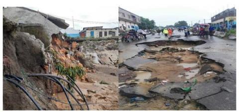
The road system in Brazzaville is thought to be extremely susceptible to flooding. One of the initial networks to be inundated is this one. However, maintaining operations and services as well as effective crisis management, such as population evacuation and resource allocation, depend on this network. Its return to service is consequently necessary for all networks. Because of this, the harm caused by network failures—regardless of their cause—is a significant consideration in disaster assessments. Though technically required to account for difficult to measure indirect damage, such as time lost as a result of a portion of the network being unavailable, these assessments still only partially reflect the extent of the damage. More generally, transport networks suffer damage to the infrastructure, the modes of transport (vehicles) and the objects to be transported. This damage then causes a change in travel demand.
The city's drinking water and wastewater networks are vulnerable to flooding. A major problem in the event of flooding is that power failures and poor water quality can disrupt the supply of drinking water. The main problems concern pumps and water transport systems. For example, as the municipality of Brazzaville does not have an emergency water source and storage facilities with sufficient capacity to ensure a supply of drinking water for the required period, the production and distribution of drinking water is often suspended for several days. We also note that water quality deteriorates after heavy rainfall. In some areas of the city vulnerable to flooding, changes in the quality of tap water are observed. The cause may be damaged or fragile pipes.
Brazzaville's electrical installations are vulnerable to varying degrees of flooding. Every year, during the rainy season between September and December, a number of neighbourhoods are not supplied with drinking water as a result of malfunctions on the electricity network. As a result, this line, whether buried or overhead, is not considered to be at great risk. On the other hand, the vulnerability of substations depends on water levels, turbidity and their location. Finally, some equipment, such as booms, apparently becomes vulnerable when it encounters high flows. Electricity networks are generally meshed at a very fine level of detail (almost everywhere, right down to the distribution of electricity to individuals). This network allows stations to temporarily or permanently replace failing stations. However, in the event of flooding, this net offers little protection. In fact, floods often affect such large areas that all the stations on the same network can be affected, and power cuts directly affect customers when they are flooded. Electricity networks are very aggressive towards other urban technical networks, but seem less dependent on them. A power failure disrupts water supply, road safety and telecommunications.
As far as fixed telephones are concerned, the sub-switchboards and therefore the subscriber lines in the city of Brazzaville are also the most affected by the floods. These elements are the most at risk because there are so many of them and they only serve a few subscribers at a time. As a result, when they were built, they were not always given special attention (in terms of flood protection) or safety. It is important to note that nodes are more fragile than links. Consequently, connections are often buried, particularly in urban areas, and various experiments have shown that buried telephone cables are extremely resilient. In addition, many cables are pressurised to prevent the ingress of water and moisture.
Compared to other cities in the sub-region, Brazzaville's vulnerability to flooding is highly unique. Significant urban sprawl has resulted from Brazzaville's unchecked spatial expansion. One effect of this phenomena is a lack of river drainage, which results from both the clogging of urban river beds, which act as natural rainwater collectors, and the inadequacy and neglect of drainage works. One of the primary causes of floods in tropical regions like Brazzaville is also thought to be the high rainfall there. Flooding during rainy seasons results in the overflow of river beds and stormwater drainage systems. The relief of the study area is made up of hills (300 to 460 m), with slopes of over 10%, and plains (270 to 300 m), with slopes of around 4%. This particular morphology, with sandy soil, leads to water erosion in the higher parts. But while rainfall, relief, soil and hydrography are factors that predispose to flooding, human activity is not to be outdone. It is even considered an aggravating factor.
3.4 Spreading vulnerability between urban networks
Analysis shows that all the technical urban networks depend on the electricity network for their operation, which is very aggressive towards the other technical urban networks. An electricity supply failure could spread the functional vulnerability to the drinking water supply network via the pump, which depend on electricity. The traffic lights on the electricity network depend on electricity for the execution of information. The road network is an essential link in the chain for the operation of other urban networks. In order to carry out repairs following damage caused by flooding, access to the site is essential. An overflowing sewage system along a road or close to the road could cause considerable disruption to traffic and emergency services. In Brazzaville, the frequency of traffic disruption is very high in areas that are highly vulnerable to flooding. Damage to the road network is also having an impact on the drinking water and electricity networks, due to their location.
The cascading effects stem from physical interdependence, where the state of infrastructure x depends on the availability of infrastructure B (e.g., water pumps and electrical power); geographical interdependence, where infrastructure x depends on the state of infrastructure Y (e.g., underground water and electricity networks, which depend on the roads covering them). There is also cybernetic interdependence, which relates to the transfer of information (as in the case of traffic lights) and logical interdependence.
The analysis shows that Brazzaville's five main technical networks, namely the road network, the electricity network, the drinking water network, the sewerage network and the telecoms network, are vulnerable to flooding due to their exposure to this phenomenon, their sensitivity and their low capacity to adapt. Given that roads and other networks such as electricity, sewerage and telecoms share the street and that the presence of one is directly and/or indirectly necessary for the smooth running of the other, the vulnerability of one network could lead to malfunctions in the other networks as a result of the interdependencies between them.
These large networks are interconnected geographically. Support networks are necessary for the proper operation of a network's infrastructures, which are scattered throughout a region. But they also provide services, occasionally with feedback loops, for other networks' infrastructures. The effects of a network failure are amplified by its complexity. A second network in a second zone may experience service disruption as a result of a service interruption to a first network in a first zone. A cascade effect is what is meant by this.
Triggering events are often natural and widespread, but sometimes occur accidentally and on a very limited scale. All the technical networks in the city of Brazzaville seem particularly prone to cascade effects, such as the power grids, road networks and drinking water network. We have observed that several triggering events can interact and occur simultaneously. This manuscript confirms Marie Bocquentin's [3] assertion that cascading effects can affect all technical networks (municipal or otherwise) due to functional or non-functional interdependencies between them. However, energy and communications seem to be the most "aggressive" with regard to other networks, although they can also have significant consequences. Not only do almost all of today's networks depend on the power supply.
The vulnerability of all the urban networks under study to this kind of interdependence demonstrates that the territorial delivery of an urban service is in fact the result of irrevocable connections between two or more infrastructures. Almost no urban service today is solely the result of its own infrastructure from a purely functional standpoint. This makes the initial division of infrastructures into different sectors or domains extremely speculative. Infrastructures cannot be seen independently since they are so unique and, in many ways, functionally interconnected. Researches by Luiijf et al. [18, 31] conclude that it is functional interdependencies that cause cascading effects and the spread of vulnerability between urban technical networks, but also amplify their reliability.
Lhomme [13] confirm that aggravating effects result from the propagation and diffusion of disturbances in space and time. Cascading failures result in an increase in the number of infrastructures affected, the number of services failing, the extent of disturbed areas, the time it takes to return to normal, etc. Worsening can also be the result of an escalation of failures.
Predicting the non-linear transmission of effects requires taking cascading effects into consideration, which is a significant factor. This sort of connection circumvents the territorialization and spatialization of dangers in the absence of established connections between infrastructures. Geographical closeness and the interchange of flows (physical or informational) between infrastructures are the two main indicators of interdependencies, respectively. When it comes to halting cascade effects or the spread of vulnerability, this sharing of space and/or flows is an important indicator that is deficient. These are challenging to stop because they happen at the "service" level rather than the "infrastructure" level.
This research focuses on understanding the cascading effects of flooding on technical networks in Brazzaville. We explored the urbanisation of urban networks and the causes of urban flooding in order to better assess the vulnerability of technical networks to urban flooding. An examination of vulnerability reveals a system of functional, geographical and/or physical interdependence within which cascading effects appear. Although the road network is the most vulnerable to flooding, it is the least aggressive with regard to other urban technical networks. On the other hand, the electricity network appears to be the most aggressive with regard to other technical urban networks.
From a sustainable urban development perspective, it seems essential to take into account the interdependencies between technical networks in all their complexity in order to better plan urban resilience to flooding. Although limited by the direct contact between water and networks and functional vulnerability, this research considers technical networks as the essential link in urban resilience. Regarding their operation, make-up, and topological organisation, these networks exhibit a wide range of characteristics. The various sorts of infrastructures that make them up might be either linear or nodal. Cities depend heavily on them, whether things are going smoothly, there is a crisis, or things are getting back to normal. We believe that these technical networks and the infrastructures supporting them can be regarded as critical infrastructures.
The author is deeply grateful to the World Bank for funding this research through CERViDA (Regional Centre for Sustainable Cities in Africa) and to the Association of Universities of Africa. Funding number IDA 5360 TG.
[1] Panhaleux, J., Renvoisé, F. (2013). Expertise sur les déplacements dans la périphérie de l’agglomération strasbourgeoise. Rapport du Conseil Général de l’Environnement et du Développement Durable, n°- 008695-01, Septembre.
[2] Rinaldi, S.M., Peerenboom, J.P., Kelly, T.K. (2001). Identifying, understanding, and analyzing critical infrastructure interdependencies. IEEE Control Systems Magazine, 21(6): 11-25. https://doi.org/10.1109/37.969131
[3] Bocquentin, M. (2020). Etude et modélisation des phénomènes d’(inter) dépendances et de défaillances en cascade au sein des réseaux techniques urbains: vers une aide à la décision pour une application à l’agglomération parisienne face à une crue majeure. Doctoral dissertation, Université Paris-Est.
[4] Toubin, M. (2014). Améliorer la résilience urbaine par un diagnostic collaboratif, l'exemple des services urbains parisiens face à l'inondation. Doctoral dissertation, Université Paris-Diderot-Paris VII.
[5] MEDD. (2005). Réduire la vulnérabilité des réseaux urbains aux inondations (p. 116) [Rapport du Ministère de l’Environnement et du Développement Durable]. Ministère de l’Environnement et du Développement Durable.
[6] Matisziw, T.C., Murray, A.T., Grubesic, T.H. (2009). Exploring the vulnerability of network infrastructure to disruption. The Annals of Regional Science, 43: 307-321. https://doi.org/10.1007/s00168-008-0235-x
[7] Johansson, J., Hassel, H. (2010). An approach for modelling interdependent infrastructures in the context of vulnerability analysis. Reliability Engineering & System Safety, 95(12): 1335-1344. https://doi.org/10.1016/j.ress.2010.06.010
[8] Kroger, S. (2008). Nothing but consultation: The place of organised civil society in EU policy-making across policies. European Governance Papers (EUROGOV). № C-08-03. http://www.connex-network.org/eurogov/pdf/egp-connex-C-08-03.pdf.
[9] La Porte, T.M. (2006). Organizational strategies for complex system resilience, reliability, and adaptation. Seeds of Disaster, Roots of Response: How Private Action Can Reduce Public Vulnerability, 135-153.
[10] La Porte, T.R. (2007). Critical infrastructure in the face of a predatory future: Preparing for untoward surprise. Journal of Contingencies and Crisis Management, 15(1): 60-64. https://doi.org/10.1111/j.1468-5973.2007.00505.x
[11] Eusgeld, I., Kröger, W., Sansavini, G., Zio, M.S.E. (2008). The role of network theory and object-oriented modeling within a frame-work for the vulnerability analysis of critical infrastructures. Reliability Engineering and System Safety, doi:10.1016/j.ress.2008.10.011
[12] Eusgeld, I., Nan, C., and Dietz, S. (2011). "System-of-systems" Approach forInterdependent Critical Infrastructures. Reliability Engineering and System Safety, 96: 679-686. https://doi.org/10.1016/j.ress.2010.12.010
[13] Lhomme, S. (2012). Les réseaux techniques comme vecteur de propagation des risques en milieu urbain-Une contribution théorique et pratique à l'analyse de la résilience urbaine. Doctoral dissertation, Université Paris-Diderot-Paris VII.
[14] Hadi. M., Imteaj, A., Pardalos, P.M. (2020). Interdependent Networks: A Data Science Perspective. Department of Industrial and Systems Engineering, University of Florida, Gainesville, FL 32611, USA. PATTER 1, April 10, 2020. https://doi.org/10.1016/j.patter.2020.100003
[15] Ash, J., Newth, D. (2007). Optimizing complex networks for resilience against cascading failure. Physica A: Statistical Mechanics and Its Applications, 380: 673-683. https://doi.org/10.1016/j.physa.2006.12.058
[16] Petit, F., Verner, D. (2016). Critical Infrastructure Interdependencies Assessment. Computation Institute, University of Chicago. https://www.osti.gov/servlets/purl/1400396
[17] Daniel, J. (2017). Quels enseignements tirer des retours d’expériences d’évènements d’inondation pour améliorer la résilience des réseaux urbains du Grand Paris? Rapport de stage.
[18] Luiijf, H.A.M., Nieuwenhuijs, A.H., Klaver, M.H., Van Eeten, M.J., Cruz, E. (2010). Empirical findings on European critical infrastructure dependencies. International Journal of System of Systems Engineering, 2(1): 3-18. https://doi.org/10.1504/IJSSE.2010.035378
[19] FEMA, Resilience report, Retrieved from, https://dnr.wi.gov/topic/FloodPlains/documents/UpperFox_ResilienceReport.pdf, 2016.
[20] Kunz, A., Fjeld, M., Sarosi, Z., Alavi, S., Landgren, J., Woźniak, P., Yantac, E. (2013). Tangible tabletops for emergency response: An exploratory study. ACM International Conference Proceeding Series. https://doi.org/10.1145/2500342.2500352
[21] Reghezza, M. (2006). Réflexions autour de la vulnérabilité métropolitaine: La métropole parisienne face au risque de crue centennale. Doctoral dissertation, Université de Nanterre-Paris X.
[22] Turner Ii, B.L. (2010). Vulnerability and resilience: Coalescing or paralleling approaches for sustainability science? Global Environmental Change, 20(4): 570-576. https://doi.org/10.1016/j.gloenvcha.2010.07.003
[23] Messner, F., Meyer, V. (2005). Flood damage, vulnerability and risk perception - challenges for flood damage research, UFZ Discussion Paper, No. 13/2005, UFZUmweltforschungszentrum Leipzig-Halle, Leipzig.
[24] Grossi, P. (2005). Catastrophe Modeling: A New Approach to Managing Risk. Springer Science & Business Media.
[25] Salami. R.O., von Meding, J.K., Giggins, H. (2017). Urban settlements’ vulnerability to flood risks in African cities: A conceptual framework. Journal of Disaster Risk Studies 9(1): a370. https://doi.org/10.4102/ jamba.v9i1.370.
[26] Arrighi, C., Pregnolato, M., Castelli, F. (2021). Flood impact on critical linear infrastructures. In FLOODrisk 2020-4th European Conference on Flood Risk Management. Budapest University of Technology and Economics. https://doi.org/10.3311/FloodRisk2020.6.3
[27] Institut national de statistique, rapport de l'enquetes par graphes à indicateurs multiples MICS5 2014. https://mics-surveys-prod.s3.amazonaws.com/MICS5/West%20and%20Central%20Africa/Congo/2014-2015/Final/Congo%202014-15%20MICS_French.pdf.
[28] Emvoulou I.J. (2019). Foncier et irrégularités à Brazzaville: cas de l’arrondissement 6 Talangaï. Mémoire de Master recherche, Ecole Africaine des Métiers de l’Architecture et de l’Urbanisme (EAMAU), Lomé, 96 p
[29] Bceom, E. (2009). Rapport diagnostic du réseau hydraulique de brazzaville. p. 95.
[30] CEPRI. (2016). The territory and its technical networks facing the risk of flooding [Le territoire et ses réseaux techniques face au risque d’inondation]. Technical Documentary Monitoring.
[31] Luiijf, H.A.M., Nieuwenhuijs, A.H., Klaver, M.H.A. (2018). Critical infrastructure dependencies 1-0-1. 2008 First International Conference on Infrastructure Systems and Services: Building Networks for a Brighter Future (INFRA), Rotterdam, Netherlands, pp. 1-3. https://doi.org/10.1109/INFRA.2008.5439621