Erwin Amri*![]() | Mary Selintung
| Mary Selintung![]() | Murshal Manaf
| Murshal Manaf![]() | Muhammad Arif Nasution
| Muhammad Arif Nasution![]()
© 2023 IIETA. This article is published by IIETA and is licensed under the CC BY 4.0 license (http://creativecommons.org/licenses/by/4.0/).
OPEN ACCESS
Suburban areas in Indonesia are densifying and transforming in an unsustainable manner, leading to uncontrolled management, spatial utilization, and control. This study aims to analyze transformation as a determinant of densification growth, the effects of physical spatial and residential transformation on densification, and the resulting contribution to settlement densification. The research method involves a combination of quantitative and qualitative approaches with a sequential explanatory design. The results indicate that spatial physical transformation has both a direct and significant impact and an indirect effect on densification through the physical transformation of residences, with an R2 value of 46.6%. Moreover, physical residence transformation has a direct and significant influence on densification, with an R2 of 47.8%. The increase in population leads to the spatial and physical transformation of residences, which positively contributes to the process of building density and the level of densification of built settlements. The spatial and physical transformation of residences contribute to changes in typology, morphology, and spatial structure during settlement densification. The morphological change of densification encourages the binary fission of housing units, residential intensification, and spatial agglomeration, as well as the growth of mixed service centers from main roads to neighborhood roads. This research helps formulate development concepts and spatial policy approaches.
development suburban, spatial transformation, physical residence transformation, densification, settlement
Global urbanization has the potential for economic growth, suburban growth, uncoordinated growth, slum and informal settlement proliferation, and land and energy consumption [1, 2]. Furthermore, urbanization promotes massive changes in spatial change, including changes in land use/land cover in large-scale housing and new cities, as well as social, economic, and environmental changes in urban regions [2, 3]. The process of urbanization drives the need for housing and settlement space and results in a process of shifting the proportion of space from urban to peri-urban areas. The increasing demand for space in urban areas leads to a process of densification. In turn, a process of spatial transformation occurs, followed by a process of transformation of the socio-economic, cultural, and physical environment of the suburbs [4].
The suburbs are experiencing growth as well as transformation due to urbanization, highlighting the peculiarities of rural-to-urban transformation [5]. Furthermore, this transformation process is reflected through the presence of urban symbols and urban activities in densely populated areas [6]. Urban transformation is a diverse set of factors, processes, and dynamics based in some places and not others, occurring globally and regionally as a result of urbanization and urban development approaches as well as transformational changes in city sub-systems [7].
Densification is a global issue that affects urban and environmental development [8]. According to the UN-Habitat concept, three significant focuses and criticisms in the global urban development agenda are planned city-infill, redevelopment, and densification [9]. Urban densification is seen as a possible solution in response to intense urbanization and sustainable development [10]. Densification is currently one of the most discussed topics in urban structure planning, research, and as a sustainable development approach to limit and prevent urban sprawl and promote compact city models. Densification of the built environment is a contemporary urban planning paradigm worldwide [11].
The development of the suburban area of Makassar City in 1989 marked the beginning of growth, which was marked by the development of large-scale settlements, namely the Bumi Tamalanrea Permai area. The Bumi Tamalanrea Permai settlement area is an area developed by the government through Perumnas, a state-owned enterprise (BUMN) in the form of a public company, which acts as a pioneer in the provision of housing and settlements for lower-middle-income people in the field of housing and residential areas and flats. The management of this national business area is divided into seven regional and regional Rusunawa business areas. Helvetia Medan, Ilir Barat Palembang, Banyumanik Semarang, Tamalanrea Makassar, and Dukuh Menanggal Surabaya. The process of traveling Perumnas Regional VII Development Areas turned into South Sulawesi Project I at the BTP Bontoa location [12]. Informal settlements and urban kampungs in Makassar, South Sulawesi, Indonesia, yield a greater contextual understanding of existing urban dynamics and spatial use patterns. Informal settlements are a manifestation of the interaction between legal frameworks, history, and socio-spatial practices, community cohesion, changes in land occupancy patterns, and settlement morphology [13].
The dynamics of land use change processes are determined by growth through increased built-up space and the dynamics of suburban transformation. The dynamics of land use change or built-up area cover in Makassar City increased by 13.92% from 7,849 ha in 2006 to 10,294 ha in 2016, or 80.37% of the total area of Makassar City in 2031 [14]. The growth of the residential area of Bumi Tamalanrea Permai and its surroundings from the 1989-1999 period occurred when built-up space reached 57.36 ha, or 21.65%, and increased to 114.49 ha, or 43.20%, in the 2000-2018 period, meaning that there was a growth in residential units; residence reached 171.85 ha, or 64.85%, for 29 years [15].
Housing plays an important role in sustainable urban development. The sustainability of housing development includes environmental, social, cultural and economic aspects of housing that are interrelated with each other [16]. The dynamics of the development of the Makassar suburban area described above illustrates the growth of the area besides being determined by the increase in large-scale settlement developed by the government and the private sector and the development of Kampong and informal settlements from the opening of development space, which grows well in a planned and natural way from the city transformation process. The transformation process is very much determined by the determining aspects, both spatially and physically, of the residence.
There are two distinct processes in suburban areas: a) urban expansion/growth/expansion; and b) a process of social, economic, political/organizational, physical, and natural (from rural to urban) transformation on the urban periphery as a result of urban growth [5, 17]. Patterns of housing growth, such as densification [18]. Gradually depends on the process of suburban transformation and becomes a dense and morphologically diverse urban area [19]. Urban transformation is a changing dynamic, issue, and approach [20]. The process of transformation and densification has the potential to cause impacts, so it is necessary to consider and balance the spatial and physical transformation of residence. Eggimann's research [21] large-scale analysis of densification potentials and their evaluation are lacking.
Issues related to the factors that determine the growth of settlement densification and causality. It is important to conceptualize this approach through the relationship between the model of large-scale settlement transformation in the suburbs and settlement densification. This conceptualization explains the cause-and-effect relationship both through the spatial-physical transformation of residences in the case of the Bumi Tamalanrea Permai residential area and its surroundings; hence, the following research hypothesis can be drawn:
(1) Spatial-densification settlement
Changes in land use owing to settlements in the Bumi Tamalanrea Permai area and its environs have an impact on physical spatial changes in response to the growth of settlement densification. Spatial transformation as a result of densification, if not accompanied by control, will have an impact on slum settlements [22].
Densification is a response to the increasing demand for space in urban areas. In turn, there will be a process of spatial transformation followed by a process of transformation of the socio-economic, cultural, and physical environment on the suburban of the city [4]. Densification growth is the result of a spatial change process and housing management strategies [14]. Some of the main characteristics of densification are increasing population density from areas of low density to areas of higher density, encouraging increased land needs and expansion of urban land [9, 23].
Conceptually, spatial transformation has been widely carried out in various fields. However, there has been no research that directly explains the cause-and-effect relationship related to densification from the perspective of residential neighborhood cases in the suburbs with different indicators. Therefore, the proposed research hypothesis is H1: The perceptual factor of spatial transformation would have a positive (+) effect on densification.
(2) Spatial-physical transformation of the residence
The transformation of neighborhoods could be explained by the contextual factors of including land-use characteristics, socio-spatial, and socio-economic factors [24]. Gradual spatial transformations in urban areas under migration pressure create different forms of urban settlements. Cases of non-camp refugee settlements (NCR) contribute to new morphological structures and cause gradual spatial changes, both socially and physically, in these settlements [25]. Spatial transformation in its spatial characteristics can be observed through the character of its morphological elements (urban form), consisting of land use patterns, transformation of road network connectivity, buildings, and public facilities and accessibility [26, 27].
Conceptually, spatial transformation has been widely carried out in various fields. However, there has been no research that directly explains the cause-and-effect relationship related to the physical transformation of residence from the perspective of settlement neighborhood cases in the suburbs with different indicators. Therefore, the proposed research hypothesis is H2: the perceptual factor of spatial transformation would have a positive (+) effect on the physical transformation of residence.
(3) Physical transformation of residence-densification of settlements
The process of building densification, there is a diffusion of social and economic infrastructure buildings towards the periphery which ultimately affects the density of buildings on the suburban of the city [4]. Physical environmental conditions have facilitated urban densification [28]. The physical transformation of residence is defined as a change in the area where a community lives. The physical transformation of a residence is synonymous with changes, adjustments, reductions, modifications, improvements and expansions to the outside and inside of the residence unit [29, 30]. Housing transformation has altered the ‘classic’ features of compound houses, namely the dwelling unit, the use of shared space and the socio-demographic profile of households [30]. The physical changes in residential that occur in the house include 3 (three) principles, namely changes in the shape and space of the house, changes in home functions, and changes in house elements [31].
Conceptually, the physical transformation of residential neighborhoods has been widely conducted in various fields. However, there is no research that directly explains the cause-and-effect relationship related to densification from the point of view of suburban residential neighborhood cases with different indicators. Therefore, the proposed research hypothesis is H3: The perceived factor of residential physical transformation will have a positive (+) effect on settlement densification.
From the research problems above, a structural development model is needed based on the construction of the theoretical concept flow. The novelty of this research is the determinant model of spatial and physical transformation of residence on the approach of suburban settlements with structural equations model analysis (SEM) path equation using Smart-PLS 3 device. For this reason, this research can fill the gap in the literature that does not yet exist regarding spatial-physical transformation of residence as a determinant of the desiccation process.
3.1 Study area
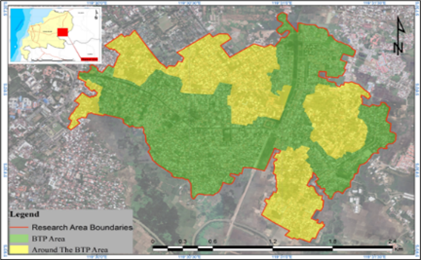
The study site is a large scale settlements on the suburban of Makassar City that serves as a case study of the Bumi Tamalanrea Permai neighborhood and surrounding area in Figure 1. The Bumi Tamalanrea Permai (BTP) residential area has an area of ±255.6Ha with 12,232 residential units, shop-houses and building lots and consists of 19 housing blocks. Development of very simple housing units (RSS), namely types 18/72, 21/84, and simple houses (RS), namely types RS 32/84-109, 36/98, 45/120, 54/153, and 70/160 [12, 14]. The surrounding area has an area of 170.69 hectares with residential rent Kodam VII Wirabuana, Telkomas Housing, and the Kampong-urban of Bontoramba, Bangkala, Cokro, Buntunsu and Katimbang.
The research method employed is a sequential explanatory design, which is preceded by quantitative and qualitative research methods. Qualitative methods are then used to explain, develop, and integrate the results from the quantitative approaches, with quantitative methods serving as the major focus [32]. This research proposes the urban transformation hypothesis as a determinant of densification using a quantitative method. Second, the contribution of spatial and residence-physical transformation processes to settlement densification. The implementation of the research process is shown in flow Figure 2.
Figure 1. Research area map, the Bumi Tamalanrea Permai (BTP) residential area and its surroundings area
Source: Author's elaboration; folder© 2021 google
Figure 2. Research process implementation flow
Source: Author's elaborator
3.2 Method of collecting data
The source of data in this research is determined by the focus and purpose of the research. Data in this study were obtained through field observations, documents, surveys, and in-depth interviews.
First, the observations in this study are used for data needs: spatial physical conditions include land use, building characteristics, land price, settlement characteristic, and circulation characteristic. Furthermore, physical conditions of housing including changes in the shape, function and elements of buildings in Bumi Tamalanrea Permai housing and its surroundings. The instruments used in the observation area were the Google Earth images to find physical residence changes, field notes, documentation tools, and checklists.
Second, questionnaires were distributed to obtain data on local community opinions and perceptions of the spatial and physical transformation of residence, namely changes in land use and changes in building characteristics, the shape and space of the house, changes in the function of houses, and changes in house elements. Furthermore, respondents' perceptions of densification, namely population and employment increase, through increasing the floor area built within the specified area, land value, location characteristics, building age, building density, and infill development, Indicators are measured through questions in the questionnaire and are given a score of: (1) strongly disagree; (2) disagree; (3) neither agree nor disagree; (4) agree; (5) strongly agree. Closed questionnaire collected via Google Form Media from October 2021 to January 2022. Respondents were selected using a purposive sampling technique of 391 respondents, aimed at the community living in the Bumi Tamalanrea Permai area: house type 18 (5 people), house type 21 (70 people), house type 30 (10 people), house type 32 (30 people), house type 36 (70 people), house type 45 (25 people), house type 54 (50 people), and house type 70 (35 people). Furthermore, it is aimed at the community living in and around the Bumi Tamalanrea Permai area (96 people). The population in this study is made up of people who have lived for at least 5 years in the Bumi Tamalanrea Permai residential area and its surroundings.
The sample was determined using a multistage random sample, namely the two stage sampling method [33]. The provisions include the characteristics of a heterogeneous community, starting with random cluster sampling and random individual sampling. Sampling by cluster random sampling includes: (i) main roads that have undergone massive residential-physical changes from land plots to residential areas to mixed land use functions; (ii) environmental roads that have changed their function from residences to areas with dual functions, namely services and trade; and (iii) environmental roads connecting the settlements of Bumi Tamalanrea Permai and its surroundings. Meanwhile, individual random sampling includes: (a) the representation of residential unit types 21, 32, 36, 45, 54, and 70 in the Bumi Tamalanrea Permai residential area; (b) the representation of the residential community of the suburban village, which is typical of stilt houses.
Third, informants in this study were used for qualitative data collection. The determination of the informants was done by the purposive sampling method, meaning that the researcher determined the person who could be interviewed and had good information about the Bumi Tamalanrea Permai Residential Area and its surrounding area. Next, the informants were selected from among several respondents who had been interviewed before. This step was intended to further explore some of the questions that were answered in the questionnaire but required a more detailed explanation. This informant was considered a "perpetrator of change" in the phenomenon of buildings and their residences. The number of informants was 15 from outside the respondents and 5 from inside the respondents. The selection of five informants from outside the respondents was based on additional information and data validity. Furthermore, the basis of consideration is experiencing environmental changes, changes in building characteristics, and physical changes in functions and elements of the house. The in-depth interview process was conducted at strategic locations with house types 21 (5 people), 45 (2 people), 70 (3 people), and land plot locations (5 people).
3.3 Data analysis method
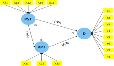
The following are the stages of research data analysis: (a) a qualitative descriptive analysis of settlement changes in land use in the periods of 2001, 2010, and 2021; furthermore, densification typologies using GIS software to describe the physical condition of the research area. A descriptive method with a phenomenological approach was used to explore and interpret the process of spatial and physical transformation of residences. (b) A quantitative descriptive analysis of the data collected from the surveys was then examined, integrated into the SPPS, and processed on the Smart-PLS 3 device. SEM-PLS simultaneously applies structural model equations and measurement model equations to build a development model [34]. Convergent validity, based on the average variance extracted (AVE) value of each indicator's loading factor, and reliability, based on the composite reliability (CR) value, are both included in the measurement model. When loading values exceed 0.7 and p is significantly less than 0.05, the requirements are met. The spatial and physical alteration of the occupancy against densification serves as the causation test. Measurement with a Likert scale to determine respondents' perceptions yielded numerical scale answers with a value of 5 as the highest value and a value of 1 as the lowest value. Measurements used a Likert scale to determine respondents' perceptions, respondents answered on a numerical scale with a value of 5 as the highest score and a value of 1 as the lowest score. The variables in this study are densification (Y) as the dependent or endogenous variable, physical spatial transformation (X1) as independent or exogenous, and residence physical transformation (X2) as intervening. The research proposed a model and variables with their indicators in Table 1. The analysis process was carried out using path equations with the Partial Least Square-Structural Equation Modeling (SmartPLS 3) approach as follows Figure 3.
$\mathrm{Y}=\mathrm{X}_1+\mathrm{X}_2+\mathrm{e}$ (1)
The dependent variable in this study is Y, and the independent variables are X1, and X2.
Figure 3. The research proposed model
Source: Author’s elaborator
Based on the formulation of the problem and the proposed research model, the results of variable identification are as follows:
Table 1. Variables their indicators and source
|
Variable |
Indicators |
Source |
|
SPT |
Land use change (X11) |
[4, 9, 35] |
|
Land value (X12) |
||
|
Building characteristics (X13) |
||
|
Settlement characteristic (X14) |
||
|
Circulation characteristic (X15) |
||
|
RPT |
Changes in the shape and space of the house (X21) |
[31] |
|
Changes in home functions (X22) |
||
|
Changes in house elements (X23) |
||
|
D |
Population and employment increase (Y1) |
[4, 9, 14, 36-38] |
|
Through increasing the floor area built within the specified area (Y2) |
||
|
Increase in residential units (Y3) |
||
|
Land price (Y4) |
||
|
Location characteristics (Y5) |
||
|
Building age (Y6) |
||
|
Building density (Y7) |
||
|
Infill development (Y8) |
Note: D=densification; SPT=spatial physical transformation; RPT=residence physical transformation.
Source: Literature review results and author's elaborator
4.1 Determinant factors of suburban transformation
The measurement output of the development model, the standard indicator measurement with a standard value of > 0.7, means that the model meets the standard, and the indicators of the variables are valid, or this indicator can explain the overall model construction.
With a standard SFL value of > 0.70 and a t-value below 1.96, the variables of densification, spatial transformation and physical transformation of the residence have fulfilled the requirements with good overall validity and reliability. The densification discriminant validity value came out to be 0.718, which was higher than the variable (Table 2). Results of value tests on the discriminant validity of residence physical and spatial transformations, where the phenomena of the value of discriminant validity are also fulfilled.
The value of the coefficient of determination (R2) concludes that the existing exogenous latent variables have been able to explain densification well because it has an R2 value of 0.47, meaning that the diversity of latent densification variables of 47% can be explained by exogenous latent variables, namely the physical-spatial and physical residence transformation variables. Other results of the existing exogenous latent variables have been able to explain the physical transformation of residence well because it has an R2 value of 0.482, meaning that the diversity of the latent physical transformation of residence of 48.2% can be explained by exogenous latent variables, namely spatial transformation (Table 3). This coefficient of determination shows that the model is correct so this test describes the determinants of physical spatial and residence physical transformation towards densification of settlements.
The value of Q2 > 0 indicates that the model has accurate predictive relevance to certain constructions, while the value of Q2 < 0 indicates that the model lacks predictive relevance [34]. The results of the analysis of the Q2 value show that the model in the combination of theory of densification, spatial transformation, and residence transformation has a positive coefficient value and having a that the model in the combination of theory of residence transformation, and spatial transformation has a. positive coefficient value and having a strong value (> 0 or 0.307). The densification Q2 value of 0.330 or 33% explains that the 2 latent variables of exogenous densification, namely spatial transformation and residential-physical transformation have a strong influence or predictive relevance strong value (> 0 or 0.330) (Table 4).
Table 2. Measurement evaluation result
|
Variable |
Indicators |
Factors Loding |
CR |
AVE |
|
SPT |
Changes in land use |
0.826 |
0.874 |
0.776 |
|
Building characteristics |
0.933 |
|||
|
RPT |
Changes in the shape and space of the house |
0.825 |
0.855 |
0.662 |
|
Changes in home functions |
0.851 |
|||
|
Changes in house elements |
0.763 |
|||
|
D |
Population and employment increase |
0.776 |
0.927 |
0.718 |
|
Increased floor area built |
0.941 |
|||
|
Increase in residential units |
0.827 |
|||
|
Building density |
0.932 |
|||
|
Infill development |
0.742 |
Note: D=densification; SPT=spatial physical transformation; RPT=residence physical transformation. Loading factor>0.70, composite reliability (CR)>0.70, average variance extracted (AVE)>0.50 [34].
Source: Author's elaborator
Table 3. Results of coefficient of determination (R2) testing
|
Variable |
R2 |
R Square Adjusted |
Q2Square Predictive Relevance |
|
Densification |
0.470 |
0.466 |
0.330 |
|
Residence physical transformation |
0.482 |
0.478 |
0.307 |
Source: Author's elaborator
Table 4. Path coefficient and p-values
|
Hypothesis |
Path |
Path Coefficients |
T Statistics (|O/STDEV|) |
P Values |
Effect/Significant |
|
H1 |
Physical spatial transformation->Densification |
0.222 |
4.047** |
0.000* |
Positive/Significant |
|
H2 |
Physical spatial transformation->Residence physical transformation |
0.548 |
12.775** |
0.000* |
Positive/Significant |
|
H3 |
Residence physical transformation->Densification |
0.506 |
10.994** |
0.000* |
Positive/Significant |
Notes: **t-value is below 1.96 and *p<0.05.
Source: Author's elaborator
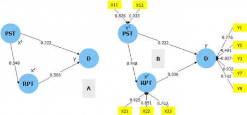
Figure 4. A: Analysis of the effect between variables; B: Analysis of indicators on variables
Source: Author's elaborator
Table 5. Total indirect effect testing
|
Indirect Effects |
Path Coefficient |
t-Count |
P Values |
|
Physical spatial transformation->Residence physical transformation->Densification |
0.278 |
8.338** |
0.000* |
Notes: **t-value is below 1.96 and *p<0.05.
Source: Author's elaborator
As Figure 4 illustrated, the path coefficient results show that of the three hypotheses proposed, all are acceptable. The path coefficient results show that spatial transformation has a positive and significant effect on densification (H1), spatial transformation has a positive and significant effect on the physical transformation of residence (H2), and the physical transformation of residence has a positive and significant effect on densification (H3). Thus, spatial transformation affects densification not only directly but also indirectly through intervention variables or the physical transformation of residence (Table 5).
4.2 The effect of spatial and physical transformations of residence on densification
The spatial physical transformation of the area which is characterized by a large-scale housing development phase driven by Perumnas VII/South Sulwesi Project for the Bumi Tamalanrea Permai location. The increase in residential space continues to experience changes in the internal area of Bumi Tamalanrea Permai which is marked by the construction of cluster housing and shop-house complexes with the typical 1-2 story building by private developers who take advantage of the policy of commercial land lot purchase. The findings show that the spatial physical transformation has a direct and indirect effect on settlement densification. This finding is in line with the conceptualisation of Giyarsih [4], Surya [22], Amri et al. [14]. The findings of this study reveal that changes in land use and changes in the characteristics of residential buildings are factors that cause spatial-physical transformations.
Changes in land use have encouraged an increase in new residential units through infill development, as well as an increase in floor area built due to an increase in population rates, with 99.10% of the population being immigrants living in the Bumi Tamalanrea area and surrounding housing, and the remaining 0.99% being natives living in villages. The growth of suburban densification is strongly linked to the speed of land use change and the realisation of the increasing demand for urban space [39]. Furthermore, increase in population contribute to increase employment and increased formal and informal economic activity on the main road to the neighborhood roads. Land use changes between 2001 and 2021, or the conversion of undeveloped space to developed residential land. Additionally, change in building characteristics contributed to the spatial transformation. In the case of the extensive settlement of Bumi Tamalanrea Permai, modifications were made to all residential types, including 18, 21, 30, 32, 36, 45, 54, and 70 with various land parcels, either by building owners or tenants. Type 70/187 has the propensity to alter by binary fission or house changes from one unit to two house units on the same plot. Furthermore, modifications in architectural characteristics from stilt dwellings to semi-permanent ones with the inclusion of space under the stilt houses in Kampong-urban communities. This means that changes in building characteristics lead to the change in the building composition, the characteristics and value of the building will be lost and change in Intensity of space utilization.
The densfication growth in the residential area of Bumi Tamalanrea, and its surroundings changes from time to time along with land use change and physical change of residence. Changes in the built up land both in the Bumi Tamalanrea Permai residential area and the surrounding settlements are due to the increase in new residential units, both individual units and new housing units and changes in function and physical building.
From Figure 4, several things can be explained related to the contribution of spatial transformation processes to settlement densification. Interpretations that can be proposed related to the process of spatial transformation in communities Bumi Tamalamrea Permai and surrounding area namely, (1) land use characteristics, trends in direction and implications of change namely, (a) densification growth has implications for the expansion of suburban settlements; (b) intensification and agglomeration of activity centres and residential service areas encourage the densification of large-scale suburban settlements. Densification contributes to large-scale residential development [40]; and (2) land use change process is a contribution to infill development. Furthermore, building characteristics, trends in direction and implications of change namely, (i) change in intensity of space utilization namely: (a) the basic building coefficient (KDB), building floor coefficient (KLB), and green area coefficient (KDH); (b) height of the building and building density; (ii) changes in the building composition of building coverage ratio (BCR), and floor area ratio (FAR). Spatial physical transformation and implications towards densification Figure 5.
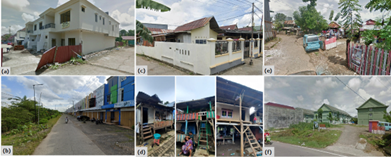
Figure 5. (a) construction of luxury housing complexes, (b) construction of shophouse complexes, (c) division of family inheritance for children's family homes, (d) land rental for migrant communities, (e) informal settlers occupying housing land, (f) rental flats for military communities
Source: Author's elaborator
Figure 6. Community perspektif of physical change to residence
Source: Author's elaborator
Figure 6 shows the implications of the change in settlement densification typology, namely: spatial change namely: (1) Infill development. The strategy of selling commercial land plots as commercial buildings as a Perumnas product that is traded to private developers by building cluster housing complexes. Typical residential units for medium and luxury communities and buildings with 1-2 floors; (2) Mature land plot for building. Sales strategy for mature land plots that contribute well to houses, shop houses that continue to undergo changes in function both services and trade. The type of shop-house building, with the distribution of mixed functions along the road and buildings with 1-5 floors. The type of building is a shop-house complex with a high land price and a building with 1-2 floors; (3) Multi-family house building. Houses building for family members determined based on the inheritance and kinship system. Distribution of building space patterns based on the provisions determined by the land owner's parents. Additional space as a place of business for each family member or a place of joint business. Stilt houses and permanent houses with 1-2 floors. The existence of a business space.
Furthermore, (4) land-lease dwellings. and rental system for buildings that are managed individually by the Bangkala kampong-urban community, migrant workers need housing and cheap land rent, and the relationship between economic and socio-cultural space in the family of fellow migrants according to their wishes and economic capabilities and preparing their own building materials. Type of building on stilts with 1 and 2 floors with different rental prices based on the floors built. The existence of supporting housing facilities; (5) Informal dwellings. For migrants who work as construction workers, public transportation drivers and motorcycle taxis who are active in the Bumi Tamalanrea Permai settlement and its surroundings. Occupy vacant land around residential areas, staying for years as long as the land has not been developed. Occupy the edge of a swamp that has not been built and usually move when the area where they live is built. Stilt houses and non-stilt wooden houses. The material used is the remaining of the old buildings in the surrounding housing. On service and sanitation facilities that have implications for slum dwellings. The widest expanse is 0.28 ha or 514 m2 which is inhabited by 20 families; (f) low-rise buildings. The potential for low-rise housing has shifted to the suburban of the city due to affordability of housing and the benefits of proximity to complete facilities. Low-rise building with 1-3 floors and a height of <20m, there is more than 1 building.
The relationship between the spatial physical transformation processes and densification in Bumi Tamalanrea Permai area strongly related increase in residential units, population and employment increase, building density and increased Infill development. Changes in the characteristics of land use and building characteristic positively contribute to the ongoing process of level of built-up densification and encourage building density.
4.3 Contribution of spatial through residence physical transformation processes to settlement densification
Spatial transformation contributes to changes in physical changes in residence. The transformation of suburban processes in Bumi Tamalanrea Permai area strongly related dynamics of the spatial to physical transformation process of residence, including: (i) spatial changes encourage the potential to increase the value of space especially land and building prices. Increase in land value due to spatial transformation [41]; (ii) urban transformation occurs due to opportunities from weak spatial control; and (iii) then the need for change continues to occur depending on the influencing factors.
Residence physical transformation positively contribute to the changes in the shape and space of the house, home functions and house elements. This finding is in line with Yuliastuti's research [31]. The interpretations that can be proposed in the development of residence physical transformation in Bumi Tamalanrea Permai settlement and its Surroundings Area above are: (i) the need for comfort and expansion of space for personal space, vehicle protection, and business motivation; (ii) the need for flood protection with changes in building elevation as adaptation to the environment; and (iii) the need for economic and investment opportunities. Furthermore, the change factors in Kampong-urban/self-help settlements that still have stilt home characteristics, caused by: (i) expansion of the Awa-bola space with the addition of family activity rooms and room rental business rooms with the addition of building elements, and (ii) addition of business buildings in the area yard as economic motivation.
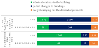
The process of physically transforming residence has undergone a level of change, namely, whole alterations to the building, partial changes to buildings, and not yet carrying out the desired adjustments Figure 7.
Figure 7. The level of physical transformation of residence
Source: Author's elaborator
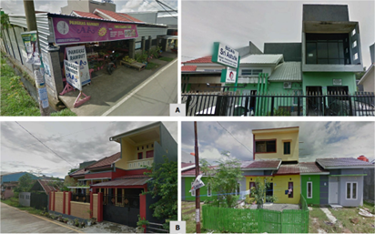
Figure 8. (a) converting and renovating a dwelling to a boarding house; (b) filling the space through the alteration of the yard of a type 21 house and the underbelly of a stilt house, (c) adding floors and roofs to a shophouse complex
Source: Author's elaborator
Figure 9. Impact of transformation on suburban settlement densification typology
Source: Author's elaborator
The interpretations that can be proposed in relation to Figure 7 and Figure 8. Above are physical transformation of the residence is gradually carried out through the initiative of both owners and tenants with continuous and dynamic changes, occurring illegally under conditions of neighbourhood pressure and economic necessity. The physical transformation of residence in the Bumi Tamalanrea Permai community will initially undergo partial or partial adjustments depending on the demands of the owner before improvements are made and the building is physically torn down. The owner has physically altered his residence since buying a housing unit in a different phase.
Figure 9 shows the implications of the change in settlement densification typology, namely (a) transforming and renovating the boarding house, change of land plots into built-up land for boarding houses due to accessibility to higher education facilities and regional health facilities and future economic and investment opportunities factors; (b) densification by filling up the house yard area. The dynamics of changing houses from the smallest type 18 to the largest type 70 still requires additional family space with the expansion of the kitchen, family room and room. The need for business opportunities by adding buildings in the backyard of the house to become a boarding house and the need for buildings for swallow nest cultivation. Implications for settlement densification typologies, namely physical changes to existing buildings through the process of filling in vacant yards and parks with the addition of 1 to 4-storey buildings with a height of <15 metres and low density; (c) Floor addition with roof staking renovation. Floor and space changes in the existing shop house complex as a need for changes in the dual economic functions of the building, namely service functions and swallow nest cultivation functions. Physical changes in housing contribute to increasing the value of space, namely increasing the number of people in the parcel and increasing family income.
Changes in the shape and space of the house, home functions and house elements positively contribute to the ongoing process of level of built-up densification and implications to density building. Diffusion buildings which ultimately affects the density of buildings on the suburban of the city [4]. Changes in the building characteristic and physical residence positively contribute to the ongoing process of level of Building density. Meaning, changes in the physical residence impact on changes in building density intervals are: (i) high density with a distance between buildings of about 0-6 meters, (ii) medium density with a distance between buildings of about 6-15 meters, and (iii) low density with a distance between building about 6-15 meters. Distance between buildings >15 meters. Impact of transformation on suburban settlement density Figure 9.
The contribution of transformation had an effect change in morphology of suburban settlement densification, including: (a) binary fission on housing units, the process of changing housing units of type 70/160-187 from 1 housing unit to 2 housing/buildings units in 1 land parcel, this trend tends to encourage settlement densification. This trend is due to the factors of space value, proximity of facilities, investment potential and the form of building division for families and tends to encourage settlement densification. In addition, the potential for mature plots of land to contribute to spatial changes towards increasing the function of services and trade as well as boarding house buildings. (b) Intensification by infill, a direction of settlement development with a horizontal increase in built dwelling units and increasing vertical residential units with densification potential in low-rise buildings in the form of simple rental flats through infill development. The Intensification, has significantly contributed to increasing the built-up area [42]. Furthermore, physical changes to dwellings through the filling of yard areas into built-up space can reduce the proportion of green gardens. The addition of floors by renovating the roof support from 2 floors to 3-4 floors, this change process will change the typology of settlement densification Figure 10.
Figure 10. A: Binary fission on housing units; B: Intensification by infill
Source: Author's elaborator
Figure 11. A: The unification of space and physical building; B: The unification of service functions both service and trade functions into residential function spaces
Source: Author's elaborator
Figure 11 shows the unification of space and physical building, from the process of physical change of the residence due to transforming and renovating the boarding house, densification by filling up the house yard area and floor addition with roof staking renovation. Furthermore, the unification of service functions both service and trade functions into residential function spaces is massive and uncontrolled from the process of physical change of the residence especially. Spatial unification encourages the agglomeration of residential areas and growth centres of large-scale settlement densification due to the connection of environmental facilities and infrastructure and encourages an integrated system of structure and spatial pattern of suburban areas.
Suburban development is a process of spatial and physical transformation of residence as a determinant of the growth of large-scale settlement densification in the suburbs of Makassar, where spatial and physical transformation have a positive and significant effect on densification and affect the physical transformation of residence. Population increases lead to changes in land use, building characteristics, and physical changes in dwellings, which contribute positively to the process of building density and encourage the level of densification of built-up settlements.
The physical transformation of a residence has a positive and significant effect on densification. The growth of densification in the residential area of Bumi Tamalanrea, and its surroundings continues to change over time, along with the process of spatial changes from land use changes, changes in building characteristics, and the process of physical changes in housing from changes in shape, space, building elements, house functions, building elevations, and the addition of house equipment, which ultimately affect the typology, morphology, and spatial structure of settlement densification.
The contribution of physical transformation of residence to settlement densification can be divided into two aspects including: (i) physical aspects, namely increase in new residential units through infill development, increase in floor area built, change in building characteristics include change in the building composition, the characteristics and value of the building will be lost and change in Intensity of space utilization; (ii) non-physical aspects, namely population and employment increase and Increased formal and informal economic activity on the main road to the neighborhood roads. Furthermore, the contribution of physical transformation of residence to settlement densification can be divided into two aspects consisting of: (i) physical aspects, namely the changes in the shape and space of the house, home functions and house elements, changes in house elements and building complements and changes in building elevation, residential and road elevation and density building; (ii) non-physical aspects, namely mands for personal space, the drive to boost family income, economic prospects in real estate, and efforts to adapt to the environment. This means that the contribution of the determinant process of suburban transformation is formed by physical aspects, namely changes in typology and morphology of large-scale settlement densification; (iii) aspects of spatial use control.
This research strengthens and develops the dynamics of the development of the suburbs of Makassar, which are experiencing the growth of settlement densification with the contribution of transformation processes that work so fast that spatial order and control cannot be controlled, so it is necessary to strengthen integrated spatial and non-spatial policies. This research is limited to the collaboration of two processes of spatial and physical residence transformation with a large-scale settlement case approach in the suburbs. Therefore, we suggest further research to examine and elaborate on the significance of economic, sociocultural, and environmental transformation aspects with different cases on both tested and untested indicators so as to illustrate the theoretical extension of urban development.
We would like to thank the research team colleagues who have struggled and contributed in supporting this research, as well as the Postgraduate Programme of Bosowa University Makassar where one of the authors is pursuing a Doctoral Programme in Urban and Regional Planning.
[1] Briassoulis, H. (2020). Analysis of Land Use Change: Theoretical and Modeling Approaches. 2nd edn. Edited by Scott Loveridge and Randall Jackson. WVU Research Repository.
[2] Surya, B., Ahmad, D.N.A., Sakti, H.H., Sahban, H. (2020). Land use change, spatial interaction, and sustainable development in the metropolitan urban areas, South Sulawesi Province, Indonesia. Land, 9(3): 95. https://doi.org/10.3390/land9030095
[3] Rustiadi, E., Pravitasari, A.E., Setiawan, Y., Mulya, S.P., Pribadi, D.O., Tsutsumida, N. (2021). Impact of continuous Jakarta megacity urban expansion on the formation of the Jakarta-Bandung conurbation over the rice farm regions. Cities, 111: 103000. https://doi.org/10.1016/j.cities.2020.103000
[4] Giyarsih, S.R. (2001). Gejala urban sprawl sebagai pemicu proses densifikasi permukiman di daerah pinggiran kota urban fringe Area. Kasus Pinggiran Kota Yogyakarta. Jurnal Perencanaan Wilayah dan Kota, 12.
[5] Follmann, A. (2022). Geographies of peri‐urbanization in the global south. Geography Compass, 16(7): e12650. https://doi.org/10.1111/gec3.12650
[6] Rahayu, P., Mardiansjah, F.H. (2018). Characteristics of peri-urbanization of a secondary city: A challenge in recent urban development. In IOP Conference Series: Earth and Environmental Science. IOP Publishing, 126(1): 012164. https://doi.org/10.1088/1755-1315/126/1/012164
[7] Hölscher, K., Frantzeskaki, N. (2021). Perspectives on urban transformation research: Transformations in of and by cities. Urban Transformations, 3: 1-14. https://doi.org/10.1186/s42854-021-00019-z
[8] Buccianti-Barakat, L., Hesse, M. (2022). The myth of beirut's resilience: Introduction to the thematic issue. Urban Planning, 7(1): 82-86. https://doi.org/10.17645/up.v7i1.5317
[9] Wang, L., Omrani, H., Zhao, Z., Francomano, D., Li, K., Pijanowski, B. (2019). Analysis on urban densification dynamics and future modes in southeastern Wisconsin, USA. PloS One, 14(3): e0211964. https://doi.org/10.1371/journal.pone.0211964
[10] Kaur, M., Hewage, K., Sadiq, R. (2020). Investigating the impacts of urban densification on buried water infrastructure through DPSIR framework. Journal of Cleaner Production, 259: 120897. https://doi.org/10.1016/j.jclepro.2020.120897
[11] Wicki, M., Hofer, K., Kaufmann, D. (2022). Planning instruments enhance the acceptance of urban densification. Proceedings of the National Academy of Sciences, 119(38): e2201780119. https://doi.org/10.1073/pnas.2201780119
[12] Perumnas Regional VII Makassar. (2021). Kantor proyek sulsel I Lokasi proyek BTP & Maros Bontoa.
[13] Josey, B.C., Ramirez-Lovering, D. (2020). Temporary appropriation of space, makassar, and urban kampung. Temporary Appropriation in Cities: Human Spatialisation in Public Spaces and Community Resilience, 171-193. https://doi.org/10.1007/978-3-030-32120-8_11
[14] Amri, E., Selintung, M., Manaf, M., Nasution, M.A. (2021). The dynamics of densification of dualistic settlements in the sub-urban area of makassar city, Indonesia. In IOP Conference Series: Earth and Environmental Science. IOP Publishing, 830(1): 012081. https://doi.org/10.1088/1755-1315/830/1/012081
[15] Ali, A.A., Selintung, M., Barkey, R.A., Thaha, M.A. (2012). Land use spatial model for building based on availability and capacity of land in territory of coastal city (Case Study: Palu City). In Asian and Pacific Coasts, 2011: 517-524. https://doi.org/10.1142/9789814366489_0060
[16] Chiu, R.L. (2004). Socio‐cultural sustainability of housing: A conceptual exploration. Housing, Theory and Society, 21(2): 65-76. https://doi.org/10.1080/14036090410014999
[17] Méndez-Lemus, Y., Vieyra, A., Poncela, L. (2017). Peri-urban local governance? Intra-government relationships and social capital in a peripheral municipality of Michoacán, Mexico. Progress in Development Studies, 17(1): 1-23. https://doi.org/10.1177/1464993416674297
[18] Broitman, D., Koomen, E. (2015). Residential density change: Densification and urban expansion. Computers, Environment and Urban Systems, 54: 32-46. https://doi.org/10.1016/j.compenvurbsys.2015.05.006
[19] Kostourou, F. (2021). Housing growth: Impacts on density, space consumption and urban morphology. Buildings and Cities, 2(1): 55-78. https://doi.org/10.5334/bc.75
[20] Salihoğlu, T., Albayrak, A.N., Eryılmaz, Y. (2021). A method for the determination of urban transformation areas in Kocaeli. Land Use Policy, 109: 105708. https://doi.org/10.1016/j.landusepol.2021.105708
[21] Eggimann, S., Wagner, M., Ho, Y.N., Züger, M., Schneider, U., Orehounig, K. (2021). Geospatial simulation of urban neighbourhood densification potentials. Sustainable Cities and Society, 72: 103068. https://doi.org/10.1016/j.scs.2021.103068
[22] Surya, B. (2016). Perubahan fisik spasial kawasan pinggiran memarginalkan komunitas lokal (Kasus Kota Baru Metro Tanjung Bunga, Makassar). Tataloka, 13(4): 212-223. https://doi.org/10.14710/tataloka.13.4.212-223
[23] Schneider, A., Woodcock, C.E. (2008). Compact, dispersed, fragmented, extensive? A comparison of urban growth in twenty-five global cities using remotely sensed data, pattern metrics and census information. Urban Studies, 45(3): 659-692. https://doi.org/10.1177/0042098007087340
[24] Chen, Y., Wen, Y., Li, Z. (2017). From blueprint to action: The transformation of the planning paradigm for desakota in China. Cities, 60: 454-465. https://doi.org/10.1016/j.cities.2016.04.010
[25] Al-Tal, R.S., Ghanem, H. (2019). Impact of the syrian crisis on the socio-spatial transformation of Eastern Amman, Jordan. Frontiers of Architectural Research, 8(4): 591-603. https://doi.org/10.1016/j.foar.2019.06.003
[26] Soetomo, S. (2009). Urbanisasi & morfologi: Proses perkembangan peradaban & wadah ruang fisiknya, menuju ruang hidup yang manusiawi. Graha Ilmu.
[27] Purnamasari, L.S., Yudana, G., Rini, E.F. (2017). Spatial transformation of Surakarta’s peripheral rural villages under in-situ urbanization phenomenon: The case of Gentan village. Geoplanning: Journal of Geomatics and Planning, 4(1): 83-96. http://dx.doi.org/10.14710/geoplanning.4.1.83-96
[28] Næss, P. (2022). Compact urban development in Norway: Spatial changes, underlying policies and travel impacts. In Advances in Transport Policy and Planning. Academic Press, 9: 95-133. https://doi.org/10.1016/bs.atpp.2021.02.003
[29] Habraken, N.J. (1983). Transformation of the Site. Cambridge, Massachusetts: A Water Press.
[30] Asante, L.A., Ehwi, R.J. (2022). Housing transformation, rent gap and gentrification in Ghana’s traditional houses: Insight from compound houses in Bantama, Kumasi. Housing Studies, 37(4): 578-604. https://doi.org/10.1080/02673037.2020.1823331
[31] Yuliastuti, N., Sukmawati, A.M.A. (2016). Transformasi perumahan sosial dan keberlanjutan perumahan di perumnas sendangmulyo. Jurnal Pengembangan Kota, 4(1): 87-94. https://doi.org/10.14710/jpk.4.1.87-94
[32] Ivankova, N.V., Creswell, J.W., Stick, S.L. (2006). Using mixed-methods sequential explanatory design: From theory to practice. Field Methods, 18(1): 3-20. https://doi.org/10.1177/1525822X05282260
[33] Aubry, P. (2021). On the non‐recursive implementation of multistage sampling without replacement. MethodsX, 8: 101553. https://doi.org/10.1016/j.mex.2021.101553
[34] Hair, J.F., Risher, J.J., Sarstedt, M., Ringle, C.M. (2019). When to use and how to report the results of PLS-SEM. European Business Review, 31(1): 2-24. https://doi.org/10.1108/EBR-11-2018-0203
[35] Surya, B., Saleh, H., Ariyanto. (2018). Transformation of metropolitan suburban area: A study on new town development in Moncongloe-Pattalassang Metropolitan Maminasata. In IOP Conference Series: Earth and Environmental Science. IOP Publishing, 202: 012027. https://doi.org/10.1088/1755-1315/202/1/012027
[36] Pelczynski, J., Tomkowicz, B. (2019). Densification of cities as a method of sustainable development. In IOP Conference Series: Earth and Environmental Science. IOP Publishing, 362(1): 012106. https://doi.org/10.1088/1755-1315/362/1/012106
[37] Cerin, E., Barnett, A., Zhang, C.J., Lai, P.C., Sit, C.H., Lee, R.S. (2020). How urban densification shapes walking behaviours in older community dwellers: A cross-sectional analysis of potential pathways of influence. International Journal of Health Geographics, 19: 1-18. https://doi.org/10.1186/s12942-020-00210-8
[38] Canesi, R. (2022). Urban policy sustainability through a value-added densification tool: The case of the south boston area. Sustainability, 14(14): 8762. https://doi.org/10.3390/su14148762
[39] Loibl, W., Toetzer, T. (2003). Modeling growth and densification processes in suburban regions-simulation of landscape transition with spatial agents. Environmental Modelling & Software, 18(6): 553-563. https://doi.org/10.1016/S1364-8152(03)00030-6
[40] Bibby, P., Henneberry, J., Halleux, J.M. (2020). Under the radar? ‘Soft’residential densification in England, 2001-2011. Environment and Planning B: Urban Analytics and City Science, 47(1): 102-118. https://doi.org/10.1177/2399808318772842
[41] Vitriana, A. (2017). Increase in land value due to spatial transformation in the northern part of the Bandung-Cimahi peri-urban region. Journal of Regional and City Planning, 28(1): 70-80. https://doi.org/10.5614/jrcp.2017.28.1.5
[42] Shekfa, L., Ahmed, K.G. (2022). The other side of the urban densification ‘Coin’: Impacts on social sustainability in redeveloped urban sprawled communities in united arab emirates. Future Cities and Environment, 8(1). https://doi.org/10.5334/fce.155