Daphne Ntlhe
© 2022 IIETA. This article is published by IIETA and is licensed under the CC BY 4.0 license (http://creativecommons.org/licenses/by/4.0/).
OPEN ACCESS
Land-use change entails changes in existing land use usually guided by spatial planning laws and the pollical influence of the state. The paper examined the impact of spatial strategies, laws, and policies on land-use change in Elim. A qualitative case study method was used to achieve the study’s purpose. Historical review of laws and satellite images of Elim in 1964, 1985, 1993, 2002, 2014, and 2020 were used to identify the impact of the rules and the extent of the land-use changes from 1964 to 2020. The study revealed that apartheid laws for creating exclusive homelands and townships for blacks significantly impacted Elim’s spatial pattern. The statutes produced displaced urbanization in homelands represented by large townships, betterment policy modernized traditional villages into compact villages with modernist characteristics, and Integrated Development Planning managed to integrate urban and rural areas to transform Elim into a mixed-use neighborhood. The analysis demonstrated that integrated and spatial development plans could guide development without zoning in rural areas, particularly in communal areas, to promote integration and create mixed-use neighborhoods. Modernist planning adopted a top-down approach, while the integrated development strategy embraces a bottom-up approach. The study will assist planners and lawmakers improve the spatial planning process.
integration, land-use, planning policy, rural development, spatial planning, urban planning
Land use is how people utilise and manage the land to sustain their lives. It can be classified into agricultural, residential, commercial, industrial, transportation, institutional and public buildings, or other land use originating from human activities that affect nature [1]. It also defines the structure and function of urban and rural environments and their benefits to human beings [2]. Land use information is indispensable in policymaking, administrative, business, and spatial planning because of its spatial details [1].
Spatial analysis help policy and decision-maker to identify problems, get an accurate description of fundamental issues, and understand problems more quickly and systematically [3]. Land-use changes occur when people use land and modify the land's natural form and processes to improve its natural ability to supply goods and services. Changes in land use also occur due to explicit or implied decisions to change the existing use by individual landowners, regional and national governments, or those who occupy land illegally [4, 5].
The changes happen at a high rate in numerous parts of the world for various reasons. Worldwide land-use patterns rapidly changed during the twentieth century due to rapid population growth, urbanisation, and industrialisation. For example, in Europe, India, China, and Africa, land-use changes are mainly caused by urbanisation [1]. Urbanisation includes expanding urban land uses and changing settlement patterns from dispersed to dense settlements. It also consists of an increasing portion of a nation’s population living in urban areas [6].
Viana and Rocha [7] studied land use and land cover (LULC) changes in the Beja district in the southeast of Portugal, using the Portuguese LULC image from 1995, 2007, 2010, 2015, and 2018. The results indicated that Beja experienced noticeable changes between 1995 and 2018. Approximately 28% of the district’s LULC have changed from arable land to permanent crops by 5%, pastures by 2.9%, fields to the forest by 3.5%, and arable land 2.7%.
Samal and Gedam [8] monitored LULC changes caused by urbanisation in India’s rapidly developing river basin and revealed that the basin’s built-up area had increased drastically due to urbanisation. In Pimpri-Chinchwad town, 288 (square kilometres) km2 has been added to the built-up area between 1992 and 2009, resulting in decreased wastelands and agricultural land. The growth of the built-up areas alongside crucial transportation networks, mainly after 2000, indicated a rapid rate of urbanisation in the basin.
A study of LULC in Shanghai, China, from 1990 to 2010 indicated that human activity significantly affects land use. Since 1990, urban and rural residential areas and other built-up places are constantly growing, meaning that Shanghai has experienced massive success in urbanisation. Land-use change indicates a significant increase in urban and rural residential areas while arable land declined [9].
In South Africa, land-use patterns have changed due to the state’s laws and policies to address population growth, urbanisation, and industrialisation. Until 1993, land-use changes responded to the modernist planning system and the racial segregation laws of the apartheid state aimed at responding to the industrialisation process [10, 11]. Since the start of the current government in 1994, it introduced new planning laws, including the integrated development planning strategy. These strategies are aimed to eradicate the former regime’s spatial manifestation and factors mentioned above [10].
In addition, land-use change is a product of decisions made by the state [5]. Most urban planning approaches have been grounded on the concept that a city is detached from rural areas. The notion of urban-rural dichotomy views a city as a base for economic growth while rural areas represent underdevelopment. The city and rural areas are treated as two different localities with no link or opposites. The Chinese situation appropriately demonstrates the dichotomy because residents in cities and rural areas have been divided into two separate societies and profit regions (communities) [6].
The land tenure system is divided into communally owned rural land and state-owned urban land, regulated by different regulations and institutions. Therefore, the division between urban and rural land governance perpetuates inequalities between urban and rural populations. Previously, urban and rural areas differed in development, functions, services, population, and other characteristics. However, current rural areas are experiencing issues usually associated with urban areas, and consequently, there is an increased interlink between these two areas [7].
The interlink emerges as transition zones between urban, rural, and suburban areas. The link creates a rural-urban continuum with no differences between rural and urban areas. The urban-rural dichotomy or divide notion does not promote sustainable development because cities do not function in isolation but have solid linkages and operate in systems at different levels that progress from regional to global [12].
According to the UN-Habitat [12], urbanisation must move from the outdated dichotomy of urban and rural areas. Therefore, urban planning should approach urban and rural regions as intricately linked economically, socially, and environmentally and cannot be satisfactorily addressed independently. For metropolitan and rural places to be sustainable, they must develop simultaneously. Inequalities must be reduced, and development gaps between and within these areas must be bridged concurrently.
In the 19th and 20th centuries, the South African urban planning system was based on the approach that considered urban areas detached from rural areas. The pre- 1994 planning approach pursued the urban-rural dualism and the separate development system that resulted in homelands development. This history of the planning approach should be considered because the transformation process does not happen in a vacuum [13].
When analysing the spatial transformation of dense settlements in former homeland areas, their historical and current political, social, and planning approach context should be included, considering that urban and rural areas are interlinked. Land-use changes and spatial transformation have been well researched in European, Indian, and Chinese cities and towns [1]. However, in South Africa, research concentrated on metropolitan areas [10, 13, 14], while similar studies in small towns and densely populated settlements in former homeland areas are still limited.
Tracing the path of planning ideas, land-use change, and spatial transformation within these settlements is a route less travelled, which resulted in a knowledge gap that this paper hopes to fill. The study intends to understand better the transformation of Elim, a former Gazankulu homeland settlement, in the context of spatial strategies, laws, and policies that influenced the settlement’s evolution.
An improved understanding of how planning laws, policies and strategies influenced the transformation of Elim and the implications of the results of this study will contribute to improving the spatial planning process in South Africa and assist in achieving spatial integration and transformation of human settlements in the country. The study is limited by the lack of published historical research in the area and region about the spatial transformation and development of settlements that provide an urban and regional planning perspective.
A secondary research method (desktop method) was used to collect data on policies and planning tools that influenced Elim’s transformation from 1910 to 2020. The method is applied in gathering existing data (secondary data) from sources that do not involve fieldwork. The method was used since data derived from the method were previously assessed, verified, evaluated, filtered, and readily available online from authentic sources - for example, open-access online journals.
Nonetheless, the data may not always be reliable and precise as per the need of the current study; hence it requires suitable modification, scrutiny, and testing to verify validity and reliability before use [15]. Satellite images were used because traditional methods of gathering data, namely, in-depth interviews, focus groups, and surveys, were not adequate due to the nature of the data needed.1964, 1985, 1993, 2002, 2014, and 2020 Elim’s satellite images were analysed to determine how the area evolved in response to the past and current spatial planning laws and policies and demonstrated developments in the settlement.
The study concluded that from the 19th century to the end of 1993, Elim’s spatial structure (land use) had been shaped by the modernist planning approach mixed with apartheid policies of separate development. Land use post-1994 was shaped by the integrated development planning strategy that promoted the integration of land uses and urban and rural areas transforming Elim into a mixed-use space. The findings and implications of this study will make a significant contribution to refining spatial planning in South Africa and aid in transforming settlements in the country.
The paper is arranged as follows. Section 2 introduces the study area and methods used in the study. Section 3 presents a literature review of the laws and land-use planning policies that impacted the study area’s spatial changes. Section 4 outlines the study’s findings; section 5 discusses how the study areas evolved in response to the past and current laws and policies. Section 6 outlines the main conclusions and limitations of the research and provides future research directions.
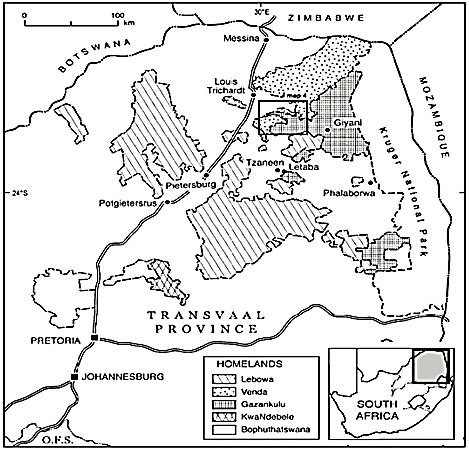
The research site is Elim locality at latitude 23°09’28 “S and 30°03’23 “E longitude within Makhado Local Municipality in Limpopo Province, South Africa. Elim was mainly a residential area reserved for the Vatsonga population during apartheid. The location was surrounded by former Venda homeland in the northern and southwestern side, South Africa in the west, and Lebowa homeland in the south. Elim’s current boundaries are aligned to Makhado Local Municipality’s planning and administrative boundaries described in the IDP and SDF of the municipality. Figure 1 shows the location of Elim within the homeland system [16].
Figure 1. Location of Elim in Gazankulu homeland
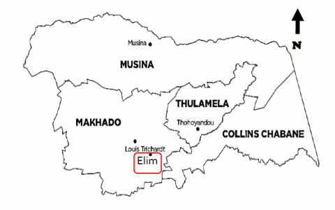
Figure 2 presents the current location of Elim in Makhado Local Municipality [17].
Figure 2. Location of Elim in Makhado Municipality
A qualitative case study was used to analyse the land-use changes in Elim in an existing locality to respond to how and why the land-use changes occurred. A qualitative case study method is a method that enables the investigation of a phenomenon within its real-life setting using different data sources. This method is suitable for answering the how and why questions while considering how the surroundings shape the phenomenon [18].
However, the method provides little basis for scientific generalisation. Also, writing the findings using this method can be challenging because data collection and analysis are continuous and concurrent [15]. The method permits data collection from various sources and modifying or processing the data to describe the case. Data derived from secondary research was employed to describe the available knowledge on the subject matter and contextualise the current study.
The method was used due to the challenges and lack of a continuous shared set of land-use or land-cover data at the correct level for various time intervals about the study area and difficulty accessing knowledgeable participants. Satellite images were used because traditional methods of gathering data, namely, in-depth interviews, focus groups, and surveys, were not adequate due to the nature of the data needed. Secondary sources were analysed to provide a description, summary, and critical evaluation of published documents relative to the research problem. Forty-five publications were selected as supporting studies or references. Furthermore, papers from which the 1964 and 1993 satellite images were sourced out were identified through the review.
Data from the above resources were also used to position the study’s findings. It is stated above that data collection and analysis are continuous and concurrent [18]. It also focused on content analysis and historical review of the laws, policies, and planning tools that influenced Elim’s development from pre-1910 to 2020. Heaton [15] describes content analysis as a research strategy that uses existing quantitative or qualitative research data to explore new problems (subject) or authenticate current data.
In addition, Google Earth Pro was utilised to extract 1985, 2002, 2014, and 2020 satellite images and determine the calculations necessary for the land use and cover changes in Elim. The land uses utilised to measure the changes and development were categorised into agricultural and built-up land (urban and rural areas). The land-use area in each year was calculated using the google earth measuring tool.
The difference or growth area was calculated by subtracting the area per year from the total size of Elim in 2020, shown in the 2020 satellite image. In summary, the satellite images were analysed to explain how the area evolved in response to the past and current spatial planning laws and policies and provided visual proof of the land-use changes in the study area. 1964, 1985, 1993, 2002, 2014, and 2020 satellite images were selected because they were available to the public and helped highlight the impact of significant policies in the past and current eras.
By 1964, apartheid laws enacted in 1950 were enforced for over a decade. Thus the 1964 image helped identify the impact of these laws on the physical structure of the area and existing land use in 1964. It provided historical background and the starting point for analysing the land-use changes. The 1985 image highlighted land use after the establishment of Gazankulu in 1973 and Waterval township in 1980, while the 1993 image was employed to compare land-use changes after 30 years since 1964 at the end of the apartheid rule.
The 2002 image emphasised the land-use shaped by the post-1994 laws before implementing IDPs in the study area. The 2014 image helped identify the land-use changes fourteen years since the IDPs in 2000. The final image, the 2020 image, provided an update on the impact of the IDPs after introducing the Spatial Planning and Land Use Management Act of 2013 (SPLUMA), the primary town planning law in South Africa. The new data in the image was used to compare land use changes fifty-six years later, from 1964. Therefore, the analysis relied more on the satellite images to show the spatial differences in the study area and estimate changes in urban (built-up area) and rural (agricultural land use) patterns through space and time.
3.1 Modernist planning
Modernist town planning emerged in developed countries from the Enlightenment philosophies at the end of the 19th century as a reaction to challenges posed by rapid urbanisation. In planning, modernism was defined as a physical design movement of the 20th century intended to counter the environmental and social shortcomings of the 19th-century city. It was introduced to create an urban society that leads well-ordered controlled lives in healthy environments while developing and improving physically and spiritually [19].
The planning system was introduced in Africa through colonialism in the 19nth century, resulting in planning strategies from Britain, Belgium, France, Portugal, and other European countries transplanted and applied in the colonies. In South Africa, the adopted British and Northern American planning systems have been merged with racial laws and policies of colonial and apartheid regimes [10, 11].
The ideological principles of the Modernist era were founded on fostering health, social security, adequate space, sunlight, and clean air for housing, work, and recreation, which are regarded as the essential functions of a city. Post-1945, planning was used as an instrument of the dominant state’ promotion of master planning, the main instrument in modernist planning, which entailed a set of urban forms and layouts with legal tools to deliver and enforce these forms driven by the state [20].
Modernist planning prioritised the aesthetic appearance of cities; high-rise buildings; domination of free-flowing vehicular movement; Separation of land use functions spatially organised into separate zones; and different residential densities for different income groups. It became the standard and accepted way of developing cities and is exemplified by Ebenezer Howard’s Garden City design and Le Corbusier’s La Ville Radieuse [19].
In Britain, Ebenezer Howard’s Garden City design intended to recreate village life by delivering green spaces in towns with meandering roads and separate cottage houses. The space is created through strict separation of land uses and through controlling the size and growth of the town to remedy the disorder of the industrial city [19].
In France, Le Corbusier established the model of a modernist city, the La Ville Radieuse, to address issues associated with the industrial city. For Le Corbusier, a society had to be highly regulated and controlled; and have an ideal city form, which must be neat, ordered, and efficient, as an essential tool of achieving that type of society. Modernist planning controlled traditional urban planning practices in Western countries and was later transplanted to developing countries [20].
South African cities, towns, and villages established in the 20th century are founded on modernist urban planning principles blended with racial segregation and class stratification. Therefore, the South African settlement patterns have been shaped like European settlements [10, 19]. According to Coetzee [20], modernist planning is criticised for its overly complex, inflexible, dictatorial, and inequitable characteristics.
In addition, it is argued that it could not address integrated urban and rural development matters relating to social and economic development growing needs. It reinforced social problems in developing countries by strengthening spatial segregation, polarising the middle and high-income population in exclusive neighbourhoods with better security and facilities on one side of the city and low-income residents with poor living conditions on the other side [19]. Furthermore, it left a legacy of infrastructures designed to meet affluent white colonisers’ neighbourhoods. For example, in Nicaragua, infrastructure developments were used to help remove and control the poor [21]. According to Watson [19], the modernist master planning approach became a convenient tool for political and economic leaders to gain power and revenue and punish opponents by implementing restrictive planning laws.
3.2 Spatial planning laws and policies before 1994
Land use planning takes place within a legal context that justifies carrying out the processes and describes the powers and duties of the institutions entrusted with the planning function. Table 1 shows laws and policies enforced by the apartheid state since 1948 that influenced town planning to follow modernist planning principles and separate development policies.
Table 1. Apartheid laws that influenced land use
|
Law |
Impact |
|
The Natives (Urban Areas) Act No. 21 of 1923 |
The Act recommended and enabled residential segregation. |
|
The Transvaal Town Planning Ordinance 11of 1931 |
It required municipalities to exercise greater control over town planning (land use, building size, and housing density) and facilitated racial zoning. |
|
Group Areas Act, Act No 41 of 1950 |
It enforced residential segregation and placed blacks at the bottom of the social hierarchy. |
|
The Physical Planning Act, 1967 (No 88 of 1967) |
It added restrictions on the employment of African workers in urban areas and facilitated the transformation of the metropolitan regions to reflect the state’s segregation ideas. |
|
The Natives Land Act, 1913 (Act No 27 of 1913) |
It allowed the demarcation of Bantustans (homelands). |
|
The Native Affairs Act, 1920 (Act No. 23 of 1920) and Black Administration Act, 1927 (No. 38 of 1927) |
Both laws created the legal basis for the autonomy of the ethnic and linguistic tribes in homelands. They gave the state the power to select and appoint traditional authorities, including relocating their jurisdiction areas. |
|
The Native Trust and Land Act, 1936 (Act No 18 of 1936) Also known as The Development Trust and Land Act, 36 (Act No 18 of 1936) |
It established the South African Native Trust (Bantu Trust and subsequently the Development Trust). The Trust was used to implement villagisation or the betterment strategy within the homelands. |
|
The Bantu Authorities Act, 1951 (Act No. 68 of 1951) |
The law empowered traditional tribal leaders to rule within their tribal homelands. |
|
The Bantu Home lands Citizenship Act No. 26 of 1970. |
It strengthened the objectives of the preceding laws [10, 13, 22, 23]. |
Table 2. Western urban planning models
|
Model |
Influence |
|
Ebenezer Howard’s Garden city model |
South Africa adopted strict zoning principles of modernist urban planning, inspired by the Garden city and Le Corbusier’s La Ville Radieuse. The Garden City model is visible in township plans, including road networks and neighbourhoods with grid road network systems [24]. |
|
Le Corbusier’s La Ville Radieuse |
The zoning system in South Africa is modelled after Le Corbusier’s central design theme, which had a strict separation of societal functions and promoted Euclidean zoning and allowed only one land use type per zone. The Ville Contemporaine’s (1922) concept of temporary workforce housing inspired the apartheid-controlled movement of blacks as temporary labour [19]. |
|
Villagisation or betterment system |
Settlements in rural areas were reformed into compact villages with grid-like streets and standardised plots under the villagisation strategy. The residential areas were divided into plots, arable lands divided into units, and common grazing ground [25, 26] |
Table 3. Laws endorsing integrated development planning
|
Law |
Impact |
|
The Constitution of South Africa, Act No 108 of 1993;1996 |
Established the three spheres of government and defined their functions regarding transforming municipalities’ socio-economic and spatial conditions. |
|
The Municipal Structures Act, 1998 (No. 117 of 1998) |
Section 151(1) endorse the “wall-to-wall” local government system. Section 81(1) allows traditional leaders to participate in municipal council meetings as ex-officio members. |
|
Municipal Systems Act, 2000 (No. 32 of 2000) |
Section 81(1)(4) requires that traditional authorities should participate in local government matters and the Integrated Development Planning process. Section 34 declared the preparation of Integrated Development Plans (IDPs) and Spatial Development Frameworks (SDF) that guide development in municipalities a legal requirement to all municipalities in the country. It requires that the IDPs and SDFs, five-year plans, facilitate Integrated Development Planning. Declares that the IDPs and SDFs should be reviewed annually following each municipality’s assessment of performance measurements [14, 27, 28]. |
3.3 Historical western urban planning models
The South African settlements’ structure or physical form cannot be attributed exclusively to the country’s colonial and apartheid planning legacies. It must also be considered within the broad context of historical western urban planning models. The apartheid urban designs drew on modernist planning principles, including those in Table 2. Rural areas are influenced by the villagisation or betterment system, which leaned on these planning models. Therefore, the apartheid system was accomplished through modernist approaches in architecture and planning to construct places and cities of inequality and racial separation [19, 25].
3.4 Spatial planning laws and policies post-1994
The democratic state adopted neoliberal policies, embracing privatisation approaches from the apartheid era and postmodernism perspectives [27, 28]. De Visser [28] states that sustainable development principles guide the current planning system, embracing postmodernism. In this era, urban planning is implemented through Integrated Development Planning, a tool for effecting Local Agenda 21 that positioned sustainable development at the centre of urban policy and planning issues. Table 3 outlines laws that promoted Integrated Development Planning from 1994 to 2012.
The fundamental initiative of Local Agenda 21 is that local communities must make their localities sustainable. Several national and municipal authorities included sustainability as the central concept in their plans and acknowledged that urban planning is an influential instrument of facilitating and achieving sustainability [29-32]. The Laws in Table 3 enacted after 1994 aim to create integrated urban and rural areas that will transform the segregated environment constructed during the apartheid era.
The use of powers mentioned in Table 3 by Municipalities directly influences the spatial development pattern of municipal areas. The Constitution embraces diversity and equality, and the National Development Plan calls for distinct planning corrective measures and results [29], which signify postmodernism principles.
The reincorporation of the homelands into white South Africa in 1994 and the delineation of the entire country into the wall-to-wall municipal system in line with the Constitution in 2000 defied the country’s primary element of spatial inequality and ethnically divided settlements. In addition to the above laws, the Spatial Planning and Land Use Management, 2013, (No. 16 of 2013) (SPLUMA), introduced in 2015, repealed all previous urban planning laws.
The Act applies to all spheres of government and provides for unified spatial planning and land use management system for the whole country. It established a spatial planning system that integrates policy, spatial planning, and land use management, especially at the local government level [33, 34]. It is intended to create equitable and sustainable development by encouraging zoning schemes. The schemes should permit spatial inclusion and plans that result in just, equitable, and efficient cities. It further demands that land-use requirements should be appropriate and be easily modified.
Section 24(2) of the Act emphasises redress, social justice, equity, and inclusion. It encourages community participation in transparent decision-making while promoting awareness of the role of property and environmental management in creating efficient and humane settlements. The Act requires that SDFs and land use management systems be applied in rural communal areas under traditional authorities. Therefore, it is intended to operate in rural localities under traditional or tribal leaders the same way as in urban areas under municipal authorities and not exclude them like in the apartheid state.
The IDP endorsed by this Act is intended to integrate rural and urban areas; unite the underprivileged and the wealthy; integrate all race groups; formal and informal neighbourhoods; localities in cities, towns and rural areas; and different land use to create integrated and compact settlements. The system is expected to create a spatial and social cohesion that links the privileged urban areas with the underprivileged townships and homelands inherited from the apartheid system [33, 34].
4.1 Planning laws, policies, and models in Elim
Elim started as a Swiss mission station in the 1880s chief (Njhakanjhaka) (tribal authority) regulated land use for farming, animal grazing, and residential purposes [35, 36]. The Union of South Africa (910 to 1947) controlled the tribal authority and regulated land use. The state applied land-use approaches exported from Western countries in Elim [10, 35, 36].
The apartheid state from (1948 to 1993) used the colonial and apartheid laws to manipulate land use. Elim’s land-use patterns reflected the intentions of separate development policies merged with the modernist planning system [19, 23]. The state used the laws and strategies in Tables 1 and 2 methodically to dispossess black farmers and the tribal authority in Elim of their land. It introduced separate development and modernist planning principles that led to tribal leaders being accountable to the state instead of their subjects (tribe).
Gazankulu homeland was established in 1973 and Waterval township in 1980 guided by the laws discussed in Tables 1 and 2. Traditional villages in communal areas within the homeland were transformed into planned villages with grid-like streets influenced by the betterment or villagisation policy in the 1960s and 70s [25]. Land in Waterval and R578 and D10 intersection is privately owned, state-owned, and communally held. To date, two-thirds of Elim’s land remains under the tribal authority [35].
Waterval adopted a modern spatial pattern that resembled Ebenezer Howard’s Garden City model explained in Table 2. In the current democratic state (1994 to 2020), the state introduced Integrated Development Planning (IDP) in 2000 and implemented Integrated Development Plans (IDPs) from 2002, applying laws outlined in Table 4 [26, 37].
From 2002 Makhado Municipality IDPs’ endorsed:- the promotion and development of the Trans-Limpopo Spatial Development activity spine; the encouragement of mixed land uses; Development of retail, commercial and informal sector opportunities and facilities; The infill of formal residential development; the creation of decentralised (rural) development nodes and activity centres where the development of higher-order activities as strategies for promoting growth and spatial development in the municipal area [37, 38].
The settlement hierarchy in the municipality originated from Limpopo Province Spatial Development Framework (2002, 2007, 2016). According to Baylis [39], the 2002 and 2007 policies were not in line with the Local Government Municipal Systems Act, 2000 (No. 32 of 2000). Consequently, the SDF was revised in 2016 to conform to the Local Government Municipal Systems Act, 2000 (No. 32 of 2000) and the SPLUMA requirements.
The Makhado Local Municipality focused on transforming settlements, nodes, and special economic zones to promote and achieve positive social, economic, and environmental sustainability benefits on municipal investments. Districts and Local Municipalities became responsible for local development planning, infrastructural development, delivery of services. Therefore, Makhado Local Municipality is responsible for providing services and implementing Integrated Development planning in Elim [37, 38].
4.2 Land-use dynamics
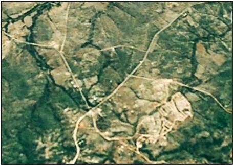
Figure 3 shows the land use in Elim in 1964. The settlement was predominantly agricultural [40].
Figure 3. 1964 Elim satellite image
Figure 4 illustrates land use in 1985 with a built-up area on the right side of the image [41].
Figure 4. 1985 Elim satellite image
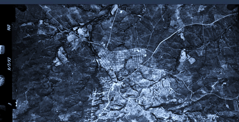
Figure 5 shows land use in Elin in 1993. The agricultural area declined while the built-up area increased.
Figure 5. 1993 Elim satellite image
Figure 6 displays land use in 2002, the built-up area increased and agricultural land continued to decline [17].
Figure 7 reveals the land use pattern in 2014. Agricultural land declined while the built environment increased [17].
Figure 6. 2002 Elim satellite image
Figure 7. Elim satellite image of 2014
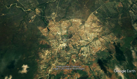
Figure 8 shows land use in Elim in 2020, signifying an increase in the built-up area.
Figure 8. Elim satellite image 2020
Table 4. Land use in Elim from 1964 to 2020
|
Year |
Agricultural land in km2 |
Built-up land in km2 |
Commercial land in km2 |
||
|
Size |
Growth |
Size |
Growth |
||
|
1964 |
20,59 |
0 |
- |
0 |
- |
|
1985 |
20,54 |
0,052 |
- |
0,0068 |
- |
|
1993 |
20,47 |
0,12 |
0,068 |
0,02 |
0,0132 |
|
2002 |
2,28 |
18,31 |
18,19 |
0,2 |
0,18 |
|
2014 |
1,11 |
19, 48 |
1,17 |
0,78 |
0,58 |
|
2020 |
0 |
20,59 |
1,11 |
0,78 |
0 |
Table 4 provides the land-use changes shown in Figures 3 to 8 in km2. The difference in size (growth) from previous years.
The growth shows that agricultural land decreased considerably between 1993 and 2002, the built-up area significantly increased in 2002, and commercial land use in 2014. In 2020 the size of the commercial area remained the same, but there was an increase in density.
4.3 Elim’s population
Population growth throughout the centuries corresponded strongly with density and land-use changes. The impact of the population on land-use form and function compared with the population requirements to establish and sustain the town centre, the township, and villages adjacent to the road intersection. The population growth is outlined in detail in Table 5 below.
Table 5. Elim’s population from 1963 to 2020
|
Year |
Population |
|
1963 1993 2011 2015 2020 |
5,200 [42] 17,365 [43] 19, 428 [44] 22,000 [45] 42,000 [44] |
In 1963 Elim had 5,200 inhabitants and from the establishment of Gazankulu homeland in 1973 and Waterval in 1985. Three decades later, in 1993, it had 17,365 people and 1,862 households [39]. The population changed by 22,572 people between 2011 and 2019, and from 1963 to 2020, it grew by 36,800 people.
The results for the period post-1994 deviate from the accepted conviction that laws and policies in this era have no impact in former homeland areas. Before 1910 the traditional land allocation system by the chief (traditional authorities) favoured dispersed African homesteads to allow pastoral farming. From 1910 to 1993, separate development laws and modernist planning models outlined in Tables 1, 2 and 3 were used to reduce and control land that belonged to the chief, black farmers, and locals within the study area. They had an impact on the spatial structure of Elim within different periods.
From 1910 to 1964, the 1913 Natives Land Act and 1923 Natives (Urban Areas) enabled residential segregation and reduced the land occupied by blacks. The laws promoted urban-rural segregation to support rapid industrialisation and secure urban development in areas reserved for the white population. The spatial impact of these laws and the traditional land allocation system resulted in dispersed traditional homesteads shown in Figure 3.
Earlier studies conducted in South Africa showed consistent results with the current research. Haarhoff [8], Maylam [13], Straus [18], and Watson [19] declared that pre and during the apartheid period, the state had controlled settlement patterns and delineated areas for black people only. 1965 to 1985, the 1920 Native Affairs Act, 1927 Black Administration Act, the 1950 Group Areas Act and the Physical Planning Act of 1967 led to the conversion of agricultural land into a built-up area comprised of residential (urban and rural) and commercial land in Figure 4 and Table 5. The built-up area signifies the land used to establish resettlement villages for the Vatsonga population in Gazankulu homeland and Waterval township.
The land-use pattern in Figure 5 also represents the effect of removing blacks from urban areas and white farms to Elim and the spatial pattern created by the apartheid laws that facilitated the creation of settlements reserved exclusively for blacks and the ethnic divide homelands and townships identified earlier. The spatial design of Waterval under the apartheid statutes strongly resembled Le Corbusier’s and Ebenezer Howard’s Garden city model designs.
The assertion is consistent with previous studies by Findley and Ogbu [24] and Haarhoff [8], who concluded that the modernist planning models under the apartheid state created grid-like streets in townships influenced by Ebenezer Howard’s Garden City model in Cape Town and Johannesburg, including small towns and the minutest villages countrywide.
The 1936 Native Trust and Land Act, 1951 Bantu Authorities Act and 1970 Bantu Homelands Citizenship Act of 1970 enabled the state to rearrange the spatial structure of homelands and facilitated the execution of the Betterment/ villagisation policy. The policy was implemented in the 1970s in Elim and reformed traditional villages into compact settlements with grid-like streets and standardised plots, diminished agriculture and changed the source of livelihood for the residents from agriculture to cash economy.
Consequently, the built-up area in Elim increased to include clearly defined road networks in villages, a township (urban area), and a commercial site (Figure 5). Studies conducted in different parts of the country that are consistent with the above results include Lahiff [25] and Seneque’s [26] who concluded that villagisation or the betterment strategy altered traditional villages by introducing planned villages with modern street patterns in Mutale River Valley and Qabeni and Beqhuqhi in the Eastern Cape.
From 1994 to 2002, the Constitution of the Republic of South Africa 1993 and the Local Government Transition Act of 1993 facilitated the incorporation of homelands into white South Africa in 1994. The 1996 Constitution of South Africa, Municipal Structures Act of 1998, and the Municipal Systems Act of 2000 facilitated the wall-to-wall municipal system that merged the urban and rural areas introduced the IDP strategy and allowed traditional authorities to take part in local government matters and the IDP process. The process led to establishing Elim/ Waterval district node [26, 37] in 2002.
The node integrated rural and urban areas and incorporated villages within the nearby Venda homeland in Elim, shown in Figure 6. The built environment transformed into a mixed-use development, a product of the IDP strategy effected through the Limpopo Province Spatial Development Framework. The argument that the laws mentioned under the 1994 to 2002 period facilitated the integration of homelands and former white South Africa and urban and rural areas is supported by Coetzee [20] and de Visser [28].
2003 to 2014, the growth of the commercial land to 0,78 km2 in 2014 and a significant decline in agricultural land (Figure 7) resulted from an increase in population to 19428 people in 2011. The growth was also stimulated by changes in the economic base and human activity (mainly informal trading and recreational activities) guided by the democratic state’s laws modelled on neoliberalism. Most of the decisions made to change the land use were in response to market prices.
Sustained change from 2015 to 2020 shown in Figure 8 was attained by applying IDPs and SPLUMA principles. The principles did not impose the Land Use Scheme on communal areas even though these areas became part of local municipalities jurisdictions. Densification occurred due to integrating rural and urban areas, homelands and former white South Africa, and population growth - creating a dense settlement.
It created a rural-urban continuum within the study area, supported by the UN-Habitat [12], which states that urbanisation must embrace the rural-urban continuum. The argument that IDPs and SPLUMA principles do not impose the Land Use Scheme on communal areas is consistent with studies by Dubazane and Nel [33], Nel [34] The Republic of South Africa [11]. Residential densities have reached urban character from original rural nature in 1964.
The paper presented an analysis of the transformation of Elim, a former Gazankulu homeland settlement, in the context of spatial strategies, laws, and policies that influenced its evolution. The conclusions drawn from this study are that the spatial manifestation of modernist planning principles and separate development ideologies separated rural areas from urban areas and people by race, ethnicity and class to promote industrialisation and urban development in areas metropolitan areas occupied by whites while depriving rural areas and disregarding sustainable development principles.
The significance of the dynamics of dispossession is that it produced displaced urbanisation exemplified by large townships with densities like those in cities in rural homelands as a feature of capitalism. Its relevance in this study is that it paved the way for socio-economic development in settlements like Elim. However, it was not the intention of the state to create such an opportunity for blacks in their homelands.
The Betterment policy was to modernise African (pastoral) agriculture; however, it eradicated agriculture, created villages with modern street patterns and water facilities, changed the inhabitants’ source of livelihood from agriculture to cash economy. It modernised the traditional rural residential areas and created a demand for commercial, industrial, and public facilities required in a diversified economic base. The subsequent land use pattern formed a foundation for integrating urban and rural areas.
The IDP allowed community participation and prioritised the communities’ needs. It guided land use without a formal Land Use Scheme promoting sustainable and affordable settlements. With South Africa’s intent to achieve inclusive development, using IDPs and SDFs without Land Use Scheme in former homelands will encourage the sustainability of the settlements by allowing multiple and mixed uses developments without the segregation and exclusionary effect of a Land Use Scheme. In this study, the very weakness of IDPs and SPLUMA is regarded as a way forward.
The results of this study should also be interpreted in the context of the limitations of this study. The study is limited by the qualitative case study method because the method has a limited basis for scientific generalisation. The satellite images used in the study are only as good as their resolution. Therefore, the satellite images might not entirely indicate reality in certain areas where minor features were represented. The lack of year-by-year satellite images depicting land-use changes in the study area from 1960 to 2020 posed a challenge in analysing the changes at a decadal interval due to the lack of available satellite images for 1974, 1984, and 2004.
The absence of publicly available detailed historical population data for the study area in the 19nth to mid-20th century restricted any population-based assessment of how population growth during these periods played a role in the development of Elim, especially with regards to the rural and urban processes such as urbanisation. Planning before 1994 was a technocratic process that promoted master planning and a top-down approach without considering sustainability issues. Post-1994, the spatial planning process is applied through IDPs and SDFs, embracing community participation and sustainable development principles embracing a bottom-up approach.
The implication of this study’s findings and conclusions is that in communal areas, land use schemes should not be used to allow mixed-use and multiple uses developments to enable sustainable development within communal areas. IDPs and SDFs should guide development the same way as in Elim without zoning, as the process will exacerbate poverty in rural communities through fees and building regulations.
Future studies could improve gaps in this study by applying technologically advanced geographic information system (GIS) mapping methods to increase the correctness of Land use changes. The studies should also focus on related topics that can provide helpful information on how the current policies can reduce the perpetual apartheid-engineered spatial patterns of the dense settlements created by the former state in the various former homeland areas to inform policy development and implementation.
[1] Onyango, D.O., Ikporukpo, C.O., Taiwo, J.O., Opiyo, S.B. (2021). Land use and land cover change as an indicator of watershed urban development in the Kenyan Lake Victoria Basin. International Journal of Sustainable Development and Planning, 16(2): 335-345. https://doi.org/10.18280/ijsdp.160213
[2] Dodankotuwa, J.B. (2017). Moving towards smart sustainable communities: A systematic literature review. Sri Lankan Journal of Real Estate, Department of Estate Management and Valuation, University of Sri Jayewardenepura, 12: 38-62. http://dr.lib.sjp.ac.lk/handle/123456789/8411
[3] Hasan, S.H., Ebraheem, A.K., Ibraheem, M.A. (2021). Adopting spatial analysis to choose suitable villages for rural development: Iraq / Babylon governorate case study. International Journal of Sustainable Development and Planning, 16(1): 165-173. https://doi.org/10.18280/ijsdp.160117
[4] Niedertscheider, M., Gingrich, S., Erb, K. (2012). Changes in land use in South Africa between 1961 and 2006: An integrated socio-ecological analysis based on the human appropriation of net primary production framework. Regional Environmental Change, 12(4): 715-727. https://doi.org/10.1007/s10113-012-0285-6
[5] Briassoulis, H. (2020). Analysis of land-use change: theoretical and modelling approaches. 2nd ed. Edited by Scott Loveridge and Randall Jackson. Morgantown, WV: Regional Research Institute, West Virginia University. https://researchrepository.wvu.edu/rri-web-book/3/.
[6] Satterthwaite, D., McGranahan, G., Tacoli, C. (2010). Urbanisation and its implications for food and farming. Philosophical Transactions of The Royal Society B Biological Sciences 365(1554): 2809-2820. https://doi.org/10.1098/rstb.2010.0136
[7] Viana, C.M., Rocha, J. (2020). Evaluating dominant land use/land cover changes and predicting future scenario in a rural region using a memoryless stochastic method. Sustainability, 12(10): 4332. https://doi.org/10.3390/su12104332
[8] Samal, D.R., Gedam, S.S. (2015). Monitoring land-use changes associated with urbanisation: An object based image analysis approach. European Journal of Remote Sensing, 48(1): 85-99. https://doi.org/10.5721/EuJRS20154806
[9] Shi, G., Jiang, N., Yao, L. (2018). Land use and cover change during the rapid economic growth period from 1990 to 2010: A Case Study of Shanghai. Sustainability, 10(2): 426. https://doi.org/10.3390/su10020426
[10] Haarhoff, E.J. (2011). Appropriating modernism: apartheid and the South African township. A|Z ITU Journal of Faculty of Architecture, 8(1): 184-195.
[11] The Republic of South Africa. (2013). Spatial Planning and Land Use Management Act No. 16 of 2013. Pretoria: Government Printers. https://www.gov.za/documents/spatial-planning-and-land-use-management-act.
[12] UN-Habitat (United Nations Human Settlements Programme). (2017). Implementing the new urban agenda by strengthening urban-rural linkages: leave no one and no space behind. Nairobi, Kenya: UN-Habitat https://unhabitat.org/implementing-the-new-urban-agenda-by-strengthening-urban-rural-linkages.
[13] Maylam, P. (1995). Explaining the apartheid city: 20 years of South African urban historiography. Journal of Southern African Studies, 21(1): 19-38. https://www.jstor.org/stable/2637329
[14] Du Plessis, D.J. (2013). A critical reflection on urban spatial planning practices and outcomes in post-apartheid South Africa. Urban Forum, 25(1): 69-88. https://doi.org/10.1007/s12132-013-9201-5
[15] Heaton, J. (2004). Reworking qualitative data. Thousand Oaks, CA: Sage.
[16] Jaennerat, C., Morier-Genoud, E., Peclard, D. (2011). Embroiled: Swiss Churches, South Africa and Apartheid. Schweizerische Afrikastudien. Münster: LIT Verlag.
[17] Municipalities of South Africa. https://municipalities.co.za/image/1132/makhado-local-municipality.
[18] Baxter, P., Jack, S. (2008). Qualitative case study methodology: Study design and implementation for novice researchers. The Qualitative Report, 13(4): 544-559. https://doi.org/10.46743/2160-3715/2008.1573
[19] Watson, V. (2009). ‘The planned city sweeps the poor away…’: Urban planning and 21st century urbanisation. Progress in Planning, 72(3): 151-193. https://doi.org/10.1016/j.progress.2009.06.002
[20] Coetzee, J. (2012). The transformation of municipal development planning in South Africa (post-1994): Impressions and impasse. Town and Regional Planning Journal, 61: 10-20. https://www.ajol.info/index.php/trp/article/view/92882
[21] Beauregard, R.A. (1991). Without a net: Modernist planning and the postmodern abyss. Journal of Planning Education and Research, 10(3): 189-194. https://doi.org/10.1177/0739456X9101000305
[22] Abubakar, I.R., Doan, P.L. (2010). New towns in Africa: Modernity and/or decentralisation. Presented at the 53rd African Studies Association Annual Meetings, San Francisco, November 18-21.
[23] Strauss, M. (2019). A historical exposition of spatial injustice and segregated urban settlement in South Africa. Fundamina, 25(2): 135-168. https://doi.org/10.17159/2411-7870/2019/v25n2a6
[24] Findley, L., Ogbu, L. (2011). South Africa: From township to town. Places Journal, 1-12. https://doi.org/10.22269/111117
[25] Lahiff, E. (1997). Land, water, and local governance in South Africa: A case study of the Mutale River Valley. Rural Resources Rural Livelihoods Working Paper Series, 7: 117. https://ageconsearch.umn.edu/record/30571?ln=en.
[26] Seneque, G.C. (1982). Betterment in South Africa. Masters Dissertation, Department of Town and Regional Planning, Faculty of Architecture, Durban: University of Natal. http://hdl.handle.net/10413/2423.
[27] Spocter, M. (2017). Privatization of municipal golf courses in small towns in the Western Cape, South Africa. South African Geographical Journal, 99(2): 113-133. https://doi.org/10.1080/03736245.2016.1208578
[28] De Visser, J. (2009). Developmental local government in South Africa: institutional fault lines. Commonwealth Journal of Local Governance, 2: 1-25. http://hdl.handle.net/10566/1251.
[29] National Planning Commission. (2012). National Development Plan: Vision for 2030. Pretoria: National Planning Commission. https://www.gov.za/documents/national-development-plan-2030-our-future-make-it-work.
[30] Yazar, K.H., Dede, O.M. (2012). Sustainable urban planning in Developed Countries: lessons for Turkey. International Journal of Sustainable Development and Planning, 7(1): 26-47. https://doi.org/10.2495/SDP-V7-N1-26-47
[31] Yigitcanlar, T., Teriman, S. (2015). Rethinking sustainable urban development: towards an integrated planning and development process. International Journal of Environmental Science and Technology, 12: 341-352. https://doi.org/10.1007/s13762-013-0491-x
[32] Echendu, A.J. (2020). Urban Planning - “It’s All About Sustainability”: Urban Planners’ Conceptualizations of Sustainable Development in Port Harcourt, Nigeria. International Journal of Sustainable Development and Planning, 15(5): 593-601. https://doi.org/10.18280/ijsdp.150501
[33] Dubazane, M., Nel, V. (2016). The Relationship of traditional leaders and the municipal council concerning land use management in Nkandla Local Municipality. Indilinga African Journal of Indigenous Knowledge Systems, 15(3): 222-238. https://hdl.handle.net/10520/EJC-533a3bd50.
[34] Nel, V. (2015). SPLUMA, zoning and effective land use management in South Africa. Urban Forum, 27: 79-92. https://doi.org/10.1007/s12132-015-9265-5
[35] Greenberg, S.J. (2011). Land reform, space and power in Makhado Municipality, Limpopo, South Africa. PhD. Dissertation, Institute of Development Studies, University of Sussex. Brighton, United Kingdom http://sro.sussex.ac.uk/id/eprint/7346/.
[36] Aliber, M., Maluleke, T., Manenzhe, T., Paradza, G., Cousins, B. (2013). Land reform and livelihoods: trajectories of change in northern Limpopo province, South Africa. Cape Town: HSRC Press. https://www.hsrcpress.ac.za/books/land-reform-and-livelihoods.
[37] Schlemmer, J.E. (2004). Mnemonic diversity: a public building for Makhado, Limpopo Province. Masters Dissertation, Department of Architecture, University of Pretoria. Pretoria. https://repository.up.ac.za/bitstream/handle/2263/25065/00front.pdf;sequence=1.
[38] Makhado Local Municipality, (2019). 2019/2020-2021/22 IDP REVIEW: Louise Trichard: Makhado Local Municipality.
[39] Baylis, S. (2011). Provincial land uses legislative reform in Limpopo Province: Status Report. Braamfontein: South African Cities Network. https://www.sacities.net/publications/.
[40] Aliber, M., Paradza, G. (2011). A tale of two dorpies: Case studies from Limpopo and a perspective on land reform and rural development policy. PowerPoint Presentation Cape Town: Institute for Poverty Land and Agrarian Studies (PLAAS) http://repository.uwc.ac.za/xmlui/handle/10566/46151.
[41] Cadman, V. (1987). Gazankulu land of refuge and relocation. Homelands Series 5. Indicator South Africa, 4(3): 101-103. https://hdl.handle.net/10520/AJA0259188X_1680.
[42] Collins, A. (1990). Producer co-operatives in the Northern Region of South Africa. 1978-1987. Southern Africa Labour and Development Research Unit. Working Paper No.77. http://opensaldru.uct.ac.za/handle/11090/590.
[43] Hartman, J.B., Kriel, J.D., Boonzaaier, C.C., Els, H., Wassermann, I. (1993). The development of tribal authorities in Gazankulu. Pretoria: University of Pretoria. https://repository.up.ac.za/handle/2263/37274.
[44] Statistics South Africa. (2011). Census 2011. Pretoria: Pretoria: Statistics South Africa. http://www.statssa.gov.za/?page_id=4286&id=12739.
[45] Statistics South Africa. (2015). Mid-year population estimates 2015. Pretoria: Statistics South Africa.