Zeffitni*![]() | Andi Rusdin
| Andi Rusdin![]() | Mery Napitupulu
| Mery Napitupulu![]() | Muhammad Basir-Cyio
| Muhammad Basir-Cyio![]() | Restu Juniah
| Restu Juniah![]()
© 2023 IIETA. This article is published by IIETA and is licensed under the CC BY 4.0 license (http://creativecommons.org/licenses/by/4.0/).
OPEN ACCESS
The earthquake disaster that struck the regions of Palu, Sigi, and Donggala on September 28, 2018, instigated liquefaction in Petobo and its surrounding areas. This study employs a hydrogeological approach, supplemented by geospatial analysis, to comprehensively evaluate the vulnerability to liquefaction in these regions, focusing specifically on hydromorphological and hydrogeological parameters such as phreatic and aquifer characteristics. Data were collected from 25 randomly selected observational dug wells in the Petobo area and its surroundings, and the analysis was facilitated by the Arc View Gis 3.3 program and satellite imagery. Based on the measurement results in 25 observation dug wells, the depth of the phreatic level was found to be shallow, at 2.25 meters from the ground surface, and its fluctuations were low, at 0.67 meters. The permeability was relatively high, averaging 49.18 meters/day. The regions experienced liquefaction avalanches in areas with a slope of less than 4%, which led to an increase in groundwater flow velocity and an elevation in the phreatic level between 2.0 and 2.5 meters. Hydrogeologically, these areas are located within the Alluvium and Pakuli formations, characterized by sand, clay, sand-clay, sand-gravel, and schist lithologies. In conclusion, the study reveals that Petobo and its surrounding areas exhibit a high vulnerability to liquefaction, ascribed to the shallow phreatic levels and high aquifer parameters observed in the alluvial plains. These findings underscore the need for careful consideration of these factors in future planning and disaster mitigation strategies in regions with similar geological and hydrogeological characteristics.
aquifer parameter, Central Sulawesi, geology, hydrogeological, hydromorphological, liquefaction, unconfined aquifer
Liquefaction, a phenomenon characterized by the loss of soil strength due to earthquake induced vibrations, predominantly manifests in sedimentary layers that are seismically active [1]. These layers, possessing a capacity for water storage and drainage, become saturated with water due to their high porosity, thereby losing stability and the ability to bear loads [2]. The main cause causing liquefaction when an earthquake occurs is due to an increase in pore water pressure (excess pore water pressure) due to cyclic stress (alternating shear stress) in the ground vibrations. The cyclic stress occurs due to the upward propagation of the shear wave originating from the center of energy release. This causes the soil to experience successive shear stresses. The actual shear stress is random but cyclic.
The liquefaction mechanism according to begins when a soil filled with saturated sand is exposed to earthquake loads. In conditions prior to the impact of the earthquake, saturated soil still has bearing strength because the contact between sand grains (effective stress) is still high compared to the pore water. Liquefaction occurs when the effective soil stress is zero. The phenomenon of liquefaction occurs when an earthquake occurs. Visually, this liquefaction event is marked by the emergence of sand mud on the ground surface in the form of sand boils, seepage of water through soil fractures, or it could also be in the form of sinking of building structures above the surface, land subsidence and lateral displacement. Evaluation of liquefaction potential in a soil layer can be determined from a combination of soil properties (grain gradation and grain size), geological environment (soil formation process, seismic history, soil surface depth).
One of the determinants of liquefaction vulnerability is the phreatic [3]. In this case, one way to analyze the liquefaction vulnerability based on phreatic using a geospatial approach [2]. Groundwater potential can be determined based on the characteristics of groundwater in hydromorphological units and hydrogeological units [4]. Landform units as a determining factor for hydromorphological conditions will generally affect the distribution of groundwater [5]. Lithological differences as a determining factor for hydrogeological conditions will affect the availability of groundwater. Information on lithology, stratigraphy and geological structures can be studied through a geomorphological approach, especially with an emphasis on landforms [6]. One of the geomorphological approaches for groundwater potential studies is to develop a morpho-hydrological map.
The interaction of lithological and process factors is reflected in the relief factor, which controls the main landform units. Variations in groundwater distribution are governed by lithological, relief, and stratigraphic factors, as well as the structure of rock layers [7]. Geological features yield vital information about the availability of groundwater, including lithology, stratigraphy, and the structure of rocks [8]. The direction of groundwater movement, type and potential of aquifers, and the value of the permeability coefficient are influenced by geological structure [9]. Stratigraphy, composed of several rock layers, impacts the type of aquifer, depth and thickness of the aquifer, and the position of groundwater [10]. Topography, lithology, and land genesis are geomorphological aspects that exert morphostructural and hydromorphological control over the characteristics of hydrogeological distribution, influencing shallow groundwater circulation [11].
Furthermore, the hydrogeological unit is a grouping of rock formations or rock units either as aquifers or not aquifers based on geological structures, especially faults, folds, and joints. The hydrogeological unit is a determining parameter for groundwater potential, because it provides information on geometry, lithology, aquifer and non-aquifer parameters, distribution and discharge of well [12, 13]. The geomorphological approach to groundwater studies in this study is used for the preparation of hydromorphological units [14]. The hydromorphological unit is a synthesis between geomorphological aspects, namely landforms and groundwater characteristics. The hydrogeological unit is a synthesis between geological aspects, namely lithology, stratigraphy and rock structures with groundwater characteristics [15, 16].
The Palu Valley and parts of the western part of the Sulawesi Island Neck are areas that are passed by the Palu-Koro fault zone [17, 18]. This fault is oriented in a north-south direction, which is likely to continue into the waters of the Makassar Strait towards and meet the North Sulawesi Trench. This fault is considered an active fault, because it is proven that there is a left lateral strike-slip shift every year at a rate of 34 - 58 mm/year [19]. Along the Palu-Koro fault line can provide an earthquake risk with the Modified Mercalli Intensity (MMI) scale level X version of the United State Geology Society (USGS) [20]. The additional risk from the Palu-Koro fault allows for liquefaction in the Quaternary sedimentary basin, landslides, and a tsunami that propagates towards Palu Bay.
Liquefaction has been a major concern in Central Sulawesi, where the combination of seismic activity and geological conditions makes the region particularly vulnerable. Understanding the hydromorphological and hydrogeological factors contributing to the liquefaction vulnerability is crucial for developing effective strategies to mitigate the impact of future earthquakes.
The earthquake disaster in the Palu, Sigi and Donggala areas on September 28, 2018 triggered liquefaction in the Petobo and surrounding areas. Petobo Village is one of the areas that experienced the incident liquefaction disaster resulting in casualties and other losses, this makes the population in Petobo Village decrease, the data obtained after the disaster shows the number of residents after the liquefaction disaster totaling 10,167 people with a total of 2,922 households. The people of Petobo Village are partly victims of the disaster liquefaction this makes people lose their homes and property. These people who have lost their homes only live in temporary shelters Petobo. The data obtained shows that the population is 825 people with total ≤117 heads of household currently living in Petobo temporary shelter is a temporary residence while the disaster victims are displaced, either in the form of mass shelters or families, or individuals. Such shelters can use existing buildings or buildable shelters quickly such as makeshift huts, tents, and so on [20]. Figure 1 shows the condition of the liquefaction disaster that occurred in the Petobo area.
Figure 1. The condition of the liquefaction disaster that occurred in the Petobo area
Based on the description of the liquefaction problems that occur in the Petobo area, Central Sulawesi Province, this study aims to provide a comprehensive assessment of the liquefaction vulnerability in Central Sulawesi, focusing on the hydromorphological and hydrogeological aspects.
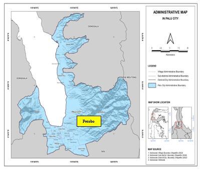
According to the Center for Environmental Geology that the Palu Basin in Central Sulawesi Province consists of several groundwater basins, namely Groundwater Basin of: Palu, Bobo, Langko, and parts of Watutua. Based on the consideration of the more complex phenomenon of spatial distribution of groundwater in Palu, this research is more focused Palu Groundwater Basin, Central Sulawesi Province. Administratively it covers parts of Palu City, at Petobo area. Figure 2 shows the research location in Petobo and its surroundings. This research was conducted in Petobo and surrounding area. This study uses a geospatial approach with hydromorphological and hydrogeological units to determine the level of liquefaction susceptibility with parameters determining unconfine aquifer [21]. The study of groundwater characteristics by compiling hydrogeological units is aimed at determining the level of potential unconfine aquifer. Geospatial analysis is intended to determine the distribution of unconfine aquifer with landform units as the unit of evaluation.
The study population includes the entire distribution of groundwater potential in Palu Groundwater Basin, Central Sulawesi Province. The research sample includes the eastern part of covering the South Palu area, especially the Petobo sub-district. Groundwater samples are intended for data collection on the characteristics of unconfine aquifer. The groundwater sampling technique is carried out by means of two stage sampling. The first level determines the sample type and sampling point. To maintain data consistency, free groundwater samples are separated between observations from dug wells. The second level, based on the area and variety of landforms, is determined by the number of sample points for data on the characteristics of groundwater using the random sampling method.
Figure 2. Administrative map of research location at Petobo area in Palu groundwater basin
Considering the limitations of the study, the groundwater sample was determined based on secondary data from pumping and geoelectrical tests from the Public Works Department of Central Sulawesi Province. These data include: piezometric surface, quantity, and aquifer parameters (permeability, transmissivity, specific yield, and aquifer thickness). Sampling by random sampling, at 25 observation points dug wells. The research method is a hydrogeological approach to the characteristics of unconfine aquifer based on the results of surveys and geospatial analysis, which is supported by the use of satellite imagery and the analysis process with the Arc View Gis 3.3 program.
The research method is survey and analysis of landform units and geological formations. Observations on landforms and geological structures were carried out at several observation points representing each groundwater characteristic. This analysis process is carried out by means of satellite image interpretation followed by field checks to compile a map of the landforms [20]. The classification of land forms is based on genetics and the scale refers to the classification of landforms on 1: 250,000 scale mapping based on the land unit map, field observations were made on the physical environmental factors related to the presence and characteristics of groundwater.
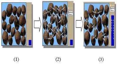
Liquefaction occurs in water saturated soil, where all the voids in the soil are filled with water. When experiencing vibrations due to earthquakes, the shear strength decreases. The loose sand and water saturation have the potential for liquefaction. Water pressure increases due to earthquake vibrations as shown in Figure 3.
In general, liquefaction occurs in areas prone to earthquakes, shallow groundwater and its soil not well consolidated. Liquefaction calculations are only carried out under conditions that meet the criteria, namely on sandy soil and water saturated conditions, with a moment magnitude (Mw) = 7.4. One of the determining factors for aquifer parameters is the permeability value. In the following Table 1, it can be seen the reservoir permeability classification. The potential for liquefaction is qualitatively influenced by the thickness of the sandy soil less than 12 meters below the ground surface, the depth of the groundwater table < 10 meters and the estimated critical limit for surface earthquake acceleration that triggers liquefaction [21].
Figure 3. Process of occurrence of liquefaction. (1) the initial conditions, (2) the condition of the soil particles when the pore water pressure occurs, (3) the condition of the soil particles when they experience vibration due to an increase in the pore water pressure
Table 1. Reservoir permeability classification
|
Permeability Value (mD) |
Classification |
|
<10 |
Fair |
|
10-100 |
High Very |
|
100-1000 |
High |
|
>1000 |
Exceptional |
3.1 Hydromorphological Petobo area
Based on landforms, geological conditions and groundwater characteristics, the Petobo area and its surroundings are categorized as hydromorphological units of alluvial plains composed of geological units in the Alluvium formation and Pakuli formation. Although in the Petobo area and its surroundings there are also denudational hilly landform units, the presence of groundwater in this landform unit is only local – local [22]. The hydromorphological unit of the alluvial plain was formed due to the geological structure of the Palu Graben which formed the Palu Groundwater Basin. The characteristics of unconfine aquifer are the basis for estimating the potential of unconfine aquifer which is determined by parameters: phreatic surface depth, groundwater fluctuations, permeability values, quantity, and quality of groundwater [23]. The results of the analysis show that the depth of the phreatic front in the Petobo and surrounding areas ranges from shallow to moderate. Furthermore, the results of the analysis of the phreatic level fluctuations show that the phreatic level fluctuations in the Petobo area are generally low (<1.0 meters).
Figure 4. Liquefaction area at Palu Basin Land Use
In Figure 4, it can be seen that the topographic map information includes relief and contour factors (250m intervals) indicating a reflection of the interaction between lithology and process factors, and is the main control factor for the landform units in Petobo. The results of the analysis show that the groundwater dividing boundary coincides with the surface water dividing boundary in the main aquifer which separates the two groundwater flows in opposite directions. In the eastern part of the structural hillside bend of Mount Gawalise and in the western part of Mount Tanggungguno.
Figure 5. Satellite image liquefaction area and landform condition at Petobo
Figure 5 shows the liquefaction area and the condition of the landform after liquefaction. Changes in the surface topography in the Petobo area and its surroundings have affected the direction of movement and the depth of the phreatic level. The morphological unit in the Petobo area and its surroundings was formed by the geological structure that developed in the form of the Palu Graben [20]. The altitude ranges from 0-50 meters above sea level, composed of alluvial sedimentary rocks consisting of: clay, silt, sand, gravel, and gravel which are the result of overhaul of the structural hills of Mount Tanggungguno and Gawalise.
The morphoprocess of the Petobo area affects the permeability, porosity, infiltration, distribution and area of the rain catchment area which is the groundwater supply, and indirectly affects the aquifer formation process in the area [23]. Morphostructure also affects the position of the groundwater phreatic level, the direction of movement and the type of groundwater. Morphochronology affects the quality and reserves of groundwater, while morphoarrangement affects the availability of groundwater in terms of quantity (the ability of the aquifer to meet groundwater needs). Figure 6 shows the shape of the land in the Petobo area and its surroundings.
Figure 6. Alluvial plains and denudational hills of Petobo and surrounding areas
Figure 7. Free groundwater potential based on hydromorphological units in the Petobo area
In Figure 7, it can be seen the free groundwater potential based on hydromorphological units in the Petobo Area. Based on the characteristics of unconfine aquifer in the hydromorphological and hydrogeological units to determine susceptibility to liquefaction that the potential susceptibility to liquefaction is very high. Landforms located on alluvial plains with geological formations composed of sand, clay, sand-clay, sand-gravel, clay and schis lithologies have a fairly high permeability value. Based on this, it can be concluded that the Petobo and surrounding areas are prone to liquefaction. Units of alluvial plains and alluvial formations have a fairly high permeability distribution value. This condition greatly affects the unconfine aquifer level and is very susceptible to liquefaction.
3.2 Hydrogeological Petobo area
The aquifer system in the Palu Groundwater Basin is formed by three groups of rocks, namely: alluvial deposits, clastic sedimentary rocks, and tertiary aged solid rocks. Alluvial deposits have a rather wide distribution, covering part of the plains of the Palu River valley. These deposits vary in thickness and are still loose and porous with low to high passability. The condition of these rocks is generally still loose to slightly solid with low to medium pass. Solid rock is generally an old rock, namely tertiary. Lithology consists of: slate, phyllite, argillite, limestone, siltstone, schist and genes. Because it has undergone several tectonic processes, this group of rocks has formed many geological structures in the form of joints.
Figure 8. Hydrogeological at Palu City (Petobo area)
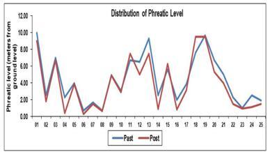
Figure 9. Distribution phreatic level past and post of liquefaction at Petobo area [5]
Based on the measurement results in 25 observation dug wells, it shows that aquifer parameters in the Petobo area and its surroundings with a phreatic level depth of 2.25 meters from the ground surface (shallow), fluctuations in the phreatic level of 0.67 meters (low) and with fairly high permeability, an average of 49.18 meters/day. The liquefaction avalanches in areas with a slope of < 4% have caused an increase in groundwater flow velocity and an increase in the phreatic of 2.0 - 2.5 meters or more details can be seen in Figure 8.
Furthermore, from Table 2 and Figure 9, it can be seen the distribution of phreatic values before and after liquefaction occurred [5]. Phreatic changes follow the topography with flow towards the alluvial plains of the Palu Valley. Groundwater level fluctuations are low due to the addition of groundwater following the topography.
Table 2. Phreatic level at Petobo area
|
Observation Point |
Past Phreatic Level (meters of Ground Level) |
Post Phreatic Level (meters of Ground Level) |
|
DW-01 |
10.00 |
9.00 |
|
DW-02 |
2.50 |
1.80 |
|
DW-03 |
7.00 |
6.70 |
|
DW-04 |
2.30 |
0.38 |
|
DW-05 |
4.00 |
3.85 |
|
DW-06 |
0.70 |
0.30 |
|
DW-07 |
1.70 |
1.50 |
|
DW-08 |
0.70 |
0.64 |
|
DW-09 |
4.97 |
4.90 |
|
DW-10 |
3.05 |
2.90 |
|
DW-11 |
6.70 |
7.50 |
|
DW-12 |
6.50 |
5.00 |
|
DW-13 |
9.30 |
7.50 |
|
DW-14 |
2.50 |
0.90 |
|
DW-15 |
5.60 |
6.26 |
|
DW-16 |
2.00 |
0.82 |
|
DW-17 |
3.86 |
3.12 |
|
DW-18 |
7.60 |
9.47 |
|
DW-19 |
9.70 |
9.50 |
|
DW-20 |
6.70 |
5.29 |
|
DW-21 |
5.00 |
4.00 |
|
DW-22 |
2.30 |
1.50 |
|
DW-23 |
1.00 |
0.92 |
|
DW-24 |
2.50 |
1.10 |
|
DW-25 |
1.90 |
1.50 |
In Figure 10, it can be seen the direction of the liquefaction avalanche. From the figure, it can be seen that the potential for liquefaction avalanches is influenced by landforms and rock lithology following the direction of groundwater flow. The following picture is an example of an alluvial plain in the Petobo area. Important aspects that affect groundwater conditions in the Petobo area and its surroundings are geological conditions (lithology, stratigraphy, and structure), geomorphological conditions (morphology, morphodynamics, morphochronology and morphoarrangements), hydrological cycles that affect the rotation and changes of water on earth, and fluid mechanics concerned with the movement of groundwater in various geological formations.
The aquifer system in the Petobo is formed by three groups of rocks, namely: alluvial deposits, clastic sedimentary rocks, and tertiary solid rocks. Alluvial deposits have a rather wide distribution, covering part of the plains of the Palu River valley. These deposits vary in thickness and are still loose and porous with low to high passability. Clastic sedimentary rocks are scattered in several places, the widest being in the Palu River valley. Stratigraphically it is under alluvial deposits and its constituents consist of: sandstone, shale, conglomerate and volcanic rock. The condition of these rocks is generally still loose to slightly solid with low to medium pass. Solid rock is generally an old rock, namely tertiary. Lithology consists of: slate, phyllite, argillite, limestone, siltstone, schist and genes. Because it has undergone several tectonic processes, this group of rocks has formed many geological structures in the form of joints.
Figure 10. The countour and direction of free groundwater flow in the Petobo area
3.3 Assessment of liquefaction vulnerability
The potential distribution of unconfine aquifer in the Petobo area is in the alluvial plain hydromorphological unit. The research findings that can be put forward are related to the potential of unconfine aquifer to liquefaction based on the characteristics of groundwater in each hydromorphological and hydrogeological unit, as follows: 1) Based on landform units, hydromorphological units are generally dominated by alluvial plain hydromorphological units, 2) The characteristics of groundwater in the Petobo area and its surroundings are different in each landform unit and are influenced by the lithology of the rocks that make up the aquifer in the Alluvium Formation, and 3) The level of relative groundwater potential based on groundwater characteristics in hydromorphological and hydrogeological units is located on alluvial plains, ranging from medium to high.
Based on the hydrogeological approach and landform units, it is known that the characteristics of the aquifer in the Petobo area are dominated by shallow aquifers in the alluvial plain land form unit and the Alluvium Formation with loamy sand-composing rock lithology. The results of analysis and measurements in the field that groundwater fluctuations in the depth of the phreatic level. The phreatic level fluctuations are generally low (<1.0 meters). Based on this, the potential for liquefaction avalanches in this area is very high with the avalanche direction from the east Tanggungguno Mountains.
The liquefaction phenomenon that occurred after the Palu Earthquake on Sunday, September 28 2018, has become the world's attention because it happened also landslides or the flow of moving soil masses. mass flow phenomenon the soil moves like mud carrying houses population which resulted in a very large loss of life in Palu City and Sigi Regency. In fact, this liquefaction phenomenon is events that have occurred in the past during major earthquakes happen. The ancestors of the Palu people had a local term for the phenomenon liquefaction, which indicates that they have recognized it for a long time. The liquefaction is known as 'nalodo' which means it sucked in by the mud. Liquefaction events in Palu City and Sigi Regency in modern times have turning the affected area into a natural laboratory on a scale of one to one (full scale). Aspects related to the process of occurrence landslides need to be studied carefully. It can deliver huge benefits for Palu City and Sigi Regency as well as the region others who are at risk of liquefaction due to earthquakes, as future mitigation efforts.
The conclusion that can be drawn in this section is that: 1) The Petobo and surrounding areas have hydromorphological units classified as alluvial plains with high to medium unconfined aquifer potential. 2) The alluvial plains consist of Alluvium and Pakuli formations with lithologies of high permeability, indicating high susceptibility to liquefaction. Based on this, it can be concluded that the Petobo and surrounding areas are prone to liquefaction. Units of alluvial plains and alluvial formations have a fairly high permeability distribution value. This condition greatly affects the unconfine aquifer level and is very susceptible to liquefaction.
This research could not be completed without the support of several parties. Thanks to the Ministry of Education, Culture, Research and Technology through the Directorate General of Higher Education, Faculty of Engineering Tadulako University who has funded this research through the budget implementation list 2023, Clinic of Environment and Mitigation Disaster, Gadjah Mada University and Geospatial Information Agency so that this research can be done smoothly.
[1] Geotechnical Report on 2018 Palu-Donggala Earthquake. (2019). https://ciptakarya.pu.go.id/admin/assets/upload/galeri/gempa/2023/02/16/163467_8_Geotechnical%20Extreme%20Events%20Reconnaissance%20The%2028%20September%202018%20M7.5%20Palu%20-%20Donggala,%20Indonesia%20Earthquake%20(VERSION%201.0_%203%20APRIL%202019).pdf.
[2] Solovey, T., Wojewódka-Przybył, M., Janica, R. (2021). Hydrochemical indicators of water source and contamination in fen peatlands of varying hydrogeomorphic settings in northern and central Poland. Ecological Indicators, 129: 107944. https://doi.org/10.1016/j.ecolind.2021.107944
[3] Zeffitni., Basir-Cyio, M., Napitupulu, M., Worosuprojo, S. (2020). Spatial analysis of the liquefaction vulnerability zone based on the phreatic level at the Palu groundwater basin, Central Sulawesi Province. Journal of Physics: Conference Series, 1434(1): 012019. https://doi.org/10.1088/1742-6596/1434/1/012019
[4] Zeffitni. (2021). Geospatial approach to determining potential of springs at the Palu Groundwater Basin for post disaster water supply in Central Sulawesi Province. In Journal of Physics: Conference Series, 1763(1): 012087.
[5] Zeffitni. (2023). Prediction of changes in the phreatic level using a hydrogeological approach in post liquefaction disasters at the Petobo area Palu groundwater Basin Central Sulawesi Province. In AIP Conference Proceedings, 2719(1): 020035. https://doi.org/10.1063/5.0133258
[6] Zeffitni. (2019). Zone of groundwater quantitative potential based on the characteristics of a confined aquifer at the Palu Groundwater Basin Central Sulawesi Province, Indonesia. International Journal of Advanced Science, Engineering, Information Technology, 9(5): 1725-1731.
[7] Adebayo, T.B., Abegunrin, T.P., Awe, G.O., Are, K.S., Guo, H., Onofua, O.E., Adegbola, G.A., Ojediran, J.O. (2021). Geospatial mapping and suitability classification of groundwater quality for agriculture and domestic uses in a Precambrian basement complex. Groundwater for Sustainable Development, 12: 100497. https://doi.org/10.1016/j.gsd.2020.100497
[8] Jang, C.S., Kuo, Y.M., Chen, S.K. (2019). Assessment of shallow groundwater use for irrigating park trees in the metropolitan Taipei Basin according to variability conditions of water quality. Journal of Hydrology X, 2: 100013. https://doi.org/10.1016/j.hydroa.2018.100013
[9] Chen, H., Yong, B., Gourley, J.J., Liu, J., Ren, L., Wang, W., Hong, Y., Zhang, J. (2019). Impact of the crucial geographic and climatic factors on the input source errors of GPM-based global satellite precipitation estimates. Journal of Hydrology, 575: 1-16. https://doi.org/10.1016/j.jhydrol.2019.05.020
[10] Sedghi, M.M., Zhan, H. (2021). Discharge variation of multiple springs associated with a fractured aquifer. Journal of Hydrology, 603: 127030. https://doi.org/10.1016/j.jhydrol.2021.127030
[11] Ruffell, A., Hunt, C.O., Grima, R., McLaughlin, R., Malone, C., Schembri, P., French, C., Stoddart, S.K. (2018). Water and cosmology in the prehistoric Maltese world: fault control on the hydrogeology of Ġgantija, Gozo (Maltese Islands). Journal of Archaeological Science: Reports, 20: 183-191. https://doi.org/10.1016/j.jasrep.2018.05.002
[12] Li, X., Zhang, Y., Li, Z., Wang, R. (2021). Response of the groundwater environment to rapid urbanization in Hohhot, the provincial capital of western China. Journal of Hydrology, 603: 127033. https://doi.org/10.1016/j.jhydrol.2021.127033
[13] Love, A.J., Shand, P., Fulton, S., Wohling, D., Karlstrom, K.E., Crossey, L., Rousseau-Gueutin, P., Priestley, S.C. (2017). A reappraisal of the hydrogeology of the Western margin of the Great Artesian Basin: Chemistry, isotopes and groundwater flow. Procedia Earth and Planetary Science, 17: 428-431. https://doi.org/10.1016/j.proeps.2016.12.108
[14] Ninasafitri, Zeffitni. (2021). Determination risk of liquifaction disaster based on spatial distribution unconfined aquifer at the Tindaki Groundwater Basin, Parigi Moutong District. Journal of Physics: Conference Series, 1763(1): 012088.
[15] Chao, H.C., Pi, J.L., You, C.F., Shieh, Y.T., Lu, H.Y., Huang, K.F., Liu, H.C., Chung, C.H. (2021). Hydrogeology constrained by multi-isotopes and volatiles geochemistry of hot springs in Tatun Volcanic Group, Taiwan. Journal of Hydrology, 600: 126515. https://doi.org/10.1016/j.jhydrol.2021.126515
[16] Verstappen, H.T. (1978). Remote sensing applications for mineral exploration. Earth Science Reviews, 14(1): 71-71. https://doi.org/10.1016/0012-8252(78)90049-1
[17] Jarzyna, J.A., Puskarczyk, E., Motyka, J. (2019). Estimating porosity and hydraulic conductivity for hydrogeology on the basis of reservoir and elastic petrophysical parameters. Journal of Applied Geophysics, 167: 11-18. https://doi.org/10.1016/j.jappgeo.2019.05.012
[18] Mutua, S., Ghysels, G., Anibas, C., Obando, J., Verbeiren, B., Van Griensven, A., Vaessens, A., Huysmans, M. (2020). Understanding and conceptualization of the hydrogeology and groundwater flow dynamics of the Nyando River Basin in Western Kenya. Journal of Hydrology: Regional Studies, 32: 100766. https://doi.org/10.1016/j.ejrh.2020.100766
[19] Zeffitni. (2020). Spatial ecological distribution of groundwater potency to domestic availability at Palu groundwater basin central Sulawesi Province. Jurnal Manusia dan Lingkungan, 19(2): 105-117. https://jurnal.ugm.ac.id/JML/article/view/18527/11820.
[20] Safapour, E., Kermanshachi, S., Pamidimukkala, A. (2021). Post-disaster recovery in urban and rural communities: Challenges and strategies. International Journal of Disaster Risk Reduction, 64: 102535. https://doi.org/10.1016/j.ijdrr.2021.102535
[21] Cavallin, A., Marchetti, M., Panizza, M., Soldati, M. (1994). The role of geomorphology in environmental impact assessment. Geomorphology, 9(2): 143-153. https://doi.org/10.1016/0169-555X(94)90072-8
[22] Basir-Cyio, M., Mahfudz, Isrun, Zeffitni. (2021). The impact of liquefaction disaster on farming systems at agriculture land based on technical and psychosocial perspectives. Plos One, 16(1): e0245591. https://doi.org/10.1371/journal.pone.0245591
[23] Kresic, N. (2010). Sustainability and management of springs. In Groundwater Hydrology of Springs, Butterworth-Heinemann. 1-29. https://doi.org/10.1016/B978-1-85617-502-9.00001-3