
Gilles Djomegne Nankam* | Cédric Djomo Chimi | Karol Lavoine Mezafack | Emmanuel Youmbi
© 2026 The authors. This article is published by IIETA and is licensed under the CC BY 4.0 license (http://creativecommons.org/licenses/by/4.0/).
OPEN ACCESS
This study aimed to analyse and spatialize long-term climate variability in relation to cocoa agroforest expansion within the Mbangassina municipality, one of the major cocoa-producing areas in Central Cameroon. Daily rainfall and temperature data, that covering the period 1981–2025 were obtained from the CHIRPS v3.0 and Copernicus-Climate Data Store platforms. Landsat imagery and field observations were used to characterize land-use and landscape dynamics. Climate variability was assessed using descriptive statistics, the Mann–Kendall trend test, and Pettitt’s change-point test, while spatial patterns were represented using Inverse Distance Weighting (IDW) interpolation. Mean annual temperature was 24.48 ± 0.70 ℃, ranging from 24.26 ℃ in 1985 to 26.02 ℃ in 2020, with a general warming tendency over the study period. Annual rainfall varied between 1257 and 1869 mm, with a mean value of 1560 ± 144 mm, and showed substantial interannual variability and an overall declining tendency. Spatially, the eastern part of Mbangassina was characterized by higher rainfall (1700–1753 mm/year) and lower temperatures (24.5–24.8 ℃). In contrast, the southeastern zone exhibited higher temperatures (around 25.4 ℃) and lower rainfall totals (1573–1618 mm/year). The spatial distribution of climatic conditions was associated with differences in forest cover, landscape fragmentation, and cocoa-agroforest development. Monthly climatic variability confirmed the presence of a humid equatorial climate with four unevenly distributed seasons. Because the study relies primarily on remotely sensed climatic and land-use information, the observed relationships should not be interpreted as evidence of direct causality. Findings highlights the importance of promoting sustainable agroforestry practices and forest restoration strategies to strengthen the climate resilience of cocoa-producing landscapes in Central Cameroon.
climate variability, trends, spatialisation, cocoa agriculture, Mbangassina, Cameroon
Climate change is currently recognized as one of the most critical environmental and socio-economic challenges affecting both natural ecosystems and human societies worldwide. Since the beginning of the industrial era, the increasing concentrations of greenhouse gases (GHGs) in the atmosphere has significantly altered the global climate system, leading to rising temperatures, changes in precipitation regimes, and an increased frequency of extreme climatic events [1]. According to the Intergovernmental Panel on Climate Change (IPCC) [2], the global mean surface temperature has already increased by approximately 1.1 ℃ above pre-industrial levels, while future projections indicate a continued warming trend throughout the 21st century. These climatic changes are particularly severe in tropical regions, where ecosystems and local livelihoods are highly dependent on climate-sensitive natural resources.
In Africa, climate variability increasingly threatens agricultural productivity, biodiversity conservation, food security, and rural livelihoods. Central Africa, despite being one of the world’s major tropical forest regions, is experiencing significant climatic changes characterized by increasing temperatures, rainfall irregularity, and prolonged dry seasons [3]. Several studies have highlighted that the Central Africa ecosystem especially the Congo Basin forests play a crucial role in regulating regional climate through evapotranspiration, carbon sequestration, and hydrological recycling [4]. However, rapid land-use changes, deforestation, and agricultural expansion are progressively altering these ecological functions and may contribute to local climatic change. Recent studies further indicate that forest degradation and fragmentation can alter local microclimates by increasing land surface temperatures and reducing atmospheric moisture recycling [5].
Among the agricultural sectors affected by climate change, cocoa plantation remains particularly vulnerable because cocoa trees require relatively stable climatic conditions, including moderate temperatures, regular rainfall, and high atmospheric humidity for optimal productivity. Optimal cocoa production generally occurs under annual rainfall ranging between 1400-2000 mm and temperatures between 21 ℃–25 ℃ [6]. Changes in rainfall distribution and temperatures can negatively affect flowering, pod formation, bean quality, and overall cocoa yield [7].
In West and Central Africa, where more than 70% of global cocoa production is concentrated, climate variability has become a major challenge for the sustainability of cocoa farming systems [8]. At the same time, the growing global demand for cocoa has contributed to the expansion of cocoa plantations into forested landscapes, leading to increased deforestation and ecosystem degradation [6].
Cameroon is one of the leading cocoa-producing countries in Africa, and cocoa farming represents an essential source of income for rural populations. Cocoa production has increased considerably over recent decades, while the Centre Region is among the principal cocoa-producing areas of the country. Recent national-scale analyses have demonstrated that climate variability is relevant to cocoa production in Cameroon, while farmer-based studies in Central Cameroon have documented strong perceptions of climate-related effects on cocoa productivity and vulnerability. In this region, cocoa agroforest expansion, logging activities, and agricultural encroachment have considerably transformed the landscape structure. Such transformations are associated with local climatic conditions through modifications of vegetation cover, soil moisture dynamics, and ecosystem functioning. Previous studies conducted in Cameroon have mainly focused on regional climate trends or cocoa production systems, with limited attention paid to the spatial relationship between climate variability, forest degradation, and cocoa agroforest expansion at the local scale.
Several studies on cocoa and climate change in Cameroon have emphasized that agroforestry systems can contribute to climate regulation and adaptation by maintaining tree cover, improving carbon storage, and regulating local microclimatic conditions [9, 10]. Cocoa agroforests, when sustainably managed, can therefore play an important role in climate change mitigation and ecological resilience. However, poorly managed of cocoa plantation including removal of shade trees, forest conversion, and plantation expansion and landscape fragmentation may alter vegetation structure, soil moisture and local energy exchanges. These changes may increase environmental degradation and increase the vulnerability of agricultural landscapes to climate variability.
Mbangassina municipality which contains remaining forest formations within a heterogeneous agricultural landscape, is particularly relevant for examining these interactions because it is an important cocoa-producing area of the Centre Region and has experienced substantial agricultural and landscape transformation. However, although previous research in Cameroon has addressed national or regional climate trends and cocoa production, relatively little attention has been given to the spatial association between long-term climate variability, land-cover transformation and cocoa agroforest development at the municipal scale.
Nevertheless, understanding these relationships is important for two reasons. First, spatial climatic heterogeneity may help identify areas where cocoa production is more exposed to warming temperature and rainfall deficits. Second, identifying associations between forest condition and climatic patterns can inform the design of agroforestry practices aimed at maintaining shade, moisture and ecological resilience. Such information is increasingly important because recent modelling indicates that the effects climate-change on cocoa suitability may differ substantially across Cameroon and other cocoa-producing countries of West and Central Africa.
Understanding the spatiotemporal trends of climatic parameters in cocoa-producing landscapes is therefore essential for designing sustainable land management and climate adaptation strategies. In this context, the present study aims to analyse the spatial and temporal variability of temperature and precipitation within the Mbangassina municipality from 1981 to 2025 and to assess their relationship with cocoa agroforest expansion and forest landscape degradation. The study seeks to contribute to a better understanding of local climate dynamics in tropical cocoa agroecosystems and to support the promotion of sustainable agroforestry practices and resilient cocoa production systems in Central Cameroon.
2.1 Study site
The present study was conducted in the Mbangassina municipality, located in the Mbam and Kim Division of the Centre Region of Cameroon. The municipality was officially established by Presidential Decree N°93/321/PR of November 25, 1993. It covers an area of approximately 815 km² and is located about 120 km from Yaoundé, the political capital of Cameroon. Mbangassina municipality comprises 19 villages. The relief of the area is moderately undulating and mainly consists of hills and plateaus, with an average altitude of approximately 550 m above sea level [11]. The study area is characterized by a sub-equatorial Guinean climate with four seasons of unequal duration: a short rainy season from March to June, a short dry season from June to mid-August, a long rainy season from mid-August to October, and a long dry season from October to March. Mean annual temperatures range from 23 ℃ to 27 ℃, while average annual rainfall is approximately 1100 mm. The soils are predominantly ferrallitic and are generally favorable for agricultural activities. Hydromorphic soils are also found along rivers and in wetland areas. The hydrographic network is relatively dense and dominated by major rivers such as the Sanaga, Mband, and Djim rivers. Phytogeographically, the area is characterized by semi-deciduous forests dominated mainly by species belonging to Malvaceae and Cannabaceae families, interspersed with savannah formations. However, these ecosystems are increasingly affected by anthropogenic disturbances, particularly agricultural expansion and cocoa plantation development. The most common tree species associated with cocoa agroforestry systems in the municipality include Triplochiton scleroxylon, Terminalia superba, Pterocarpus soyauxii, Milicia excelsa, and Eribroma oblongum. Agriculture constitutes the main economic activity of the local population and is largely dominated by cocoa cultivation, alongside subsistence crops such as yam, cassava, banana, and cocoyam. Mbangassina is therefore recognized as one of the major cocoa-producing areas in the Centre Region of Cameroon.
2.2 Climate and spatial data collection
This study focused on two main climatic variables: temperature and precipitation. Daily rainfall data were obtained from the CHIRPS v3 (Climate Hazards Center Infrared Precipitation with Stations) satellite database through the official Climate Hazards Group platform (https://data.chc.ucsb.edu/products/CHIRPS/v3.0/). Daily temperature data were obtained from ERA5-Land dataset available through the official Copernicus Climate Data Store portal available at https://cds.climate.copernicus.eu/datasets. The climatic dataset covered a continuous period of 45 years, from 1981 to 2025, corresponding to approximately 16,060 daily observations.
This temporal coverage exceeds the 30-year minimum period recommended by the World Meteorological Organization for climate variability and climate change assessments [12]. These datasets are particularly suitable for tropical regions characterized by a low density of meteorological stations, as is commonly observed in Central Africa and especially in Cameroon. The selection of the CHIRPS and ERA-based datasets was further justified by their strong performance in regional climate assessments. Previous validation studies have shown that CHIRPS and ERA climatic estimates are generally consistent with ground-based rainfall and temperature observations and provide reliable results for environmental and climate monitoring applications [13].
In addition to climatic data, Landsat satellite imagery (Landsat 8 with 30 m resolution) of the Mbangassina municipality was acquired and combined with field observations (collected using a GPS) to produce a spatial characterization of landscape dynamics for the year 2025. These satellite images were used to identify areas affected by forest degradation associated with cocoa agroforest expansion and to examine their relationship with the spatial distribution of climatic parameters.
2.3 Data analysis
Climate variability over the 1981–2025 period was analyzed using the R statistical software (version 4.5). The analysis first involved testing for serial dependence in the time series using the Durbin–Watson test. This test assesses residual autocorrelation in order to verify residual independence and ensure the validity of subsequent statistical analyses. It did not indicate significant serial autocorrelation in the residuals, supporting the use of subsequent trend analyses. Because temporal autocorrelation can influence the interpretation of trend tests, the results were interpreted cautiously. Thereafter, several complementary analytical approaches were applied. Descriptive statistics of temperature and precipitation were computed at both monthly and annual scales to characterize the spatiotemporal variability of climatic conditions within the Mbangassina municipality and to identify long-term climatic trends. Climatic evolution graphs were also generated to visualize the temporal dynamics of the two climatic variables considered in this study. Monotonic trends in climatic series were assessed using the non-parametric Mann-Kendall test. It is appropriate for climatic data because it does not require the observations to follow a normal distribution and is relatively robust to non-linear monotonic changes. Potential change points and abrupt shifts in the time series were detected using Pettitt’s test. It is useful for detecting a shift in the central tendency of a time series and therefore complements the Mann–Kendall test, which primarily evaluates monotonic trends. All statistical analyses were performed in R version 4.5 using several specialized packages, including bayesforecast, mmkh, tidyverse, GGally, gridExtra, ggpubr, readxl, ggsci, ggrepel, ggforce, gplots, and ggplot2. To ensure spatial consistency among the different datasets, precipitation and temperature values were interpolated from their original grids into a common reference grid. The Inverse Distance Weighting (IDW) interpolation method was applied to generate continuous spatial representations of mean annual rainfall and temperature across the study area. IDW assumes greater similarity between geographically closer observations and that it does not explicitly incorporate environmental variables such as elevation, atmospheric circulation or soil moisture.
Finally, QGIS software was used to map land-cover for the year 2025. This spatial analysis enabled the identification of areas undergoing significant forest degradation [14] linked to cocoa plantation expansion and facilitated the examination of their relationship with climate variability.
3.1 Trends in climatic parameters
3.1.1 Temperature variations from 1981 to 2025
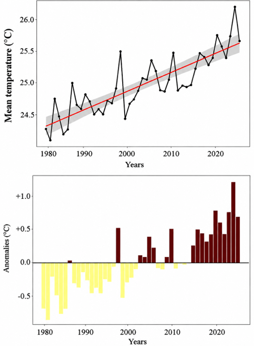
The temporal evolution of mean annual temperatures recorded in the Mbangassina municipality over the 1981–2025 period showed an overall mean of 24.48 ± 0.70 ℃. The lowest mean annual temperature (24.26 ℃) was recorded in 1985, whereas the highest (26.02 ℃) was observed in 2020.
The analysis of annual temperature anomalies for the 1981–2025 period made it possible to identify years characterized by unusually cool conditions (negative anomalies) and unusually warm conditions (positive anomalies). Figure 1 shows that negative anomalies predominated during the early years of the study period. The most pronounced thermal deficits occurred around 1982, with anomalies close to −0.85 ℃, as well as during 1985 and 1986, when anomalies reached approximately −0.7 ℃. These results suggest that annual temperatures during the first decades of the time series were frequently below the long-term climatic average.
Figure 1. Temporal variation and temperature anomalies in the Mbangassina municipality from 1981 to 2025
From the late 1990s onward, and more markedly during the 2000s, temperature anomalies progressively shifted toward more frequent and stronger positive values. Several years exhibited anomalies exceeding +0.5 ℃, particularly 1998, 2010, 2018, and especially 2024, which recorded a remarkably high anomaly exceeding +1.2 ℃. This pattern indicates a progressive increase in both the frequency and intensity of abnormally warm years within the Mbangassina municipality.
3.1.2 Rainfall variations from 1981 to 2025
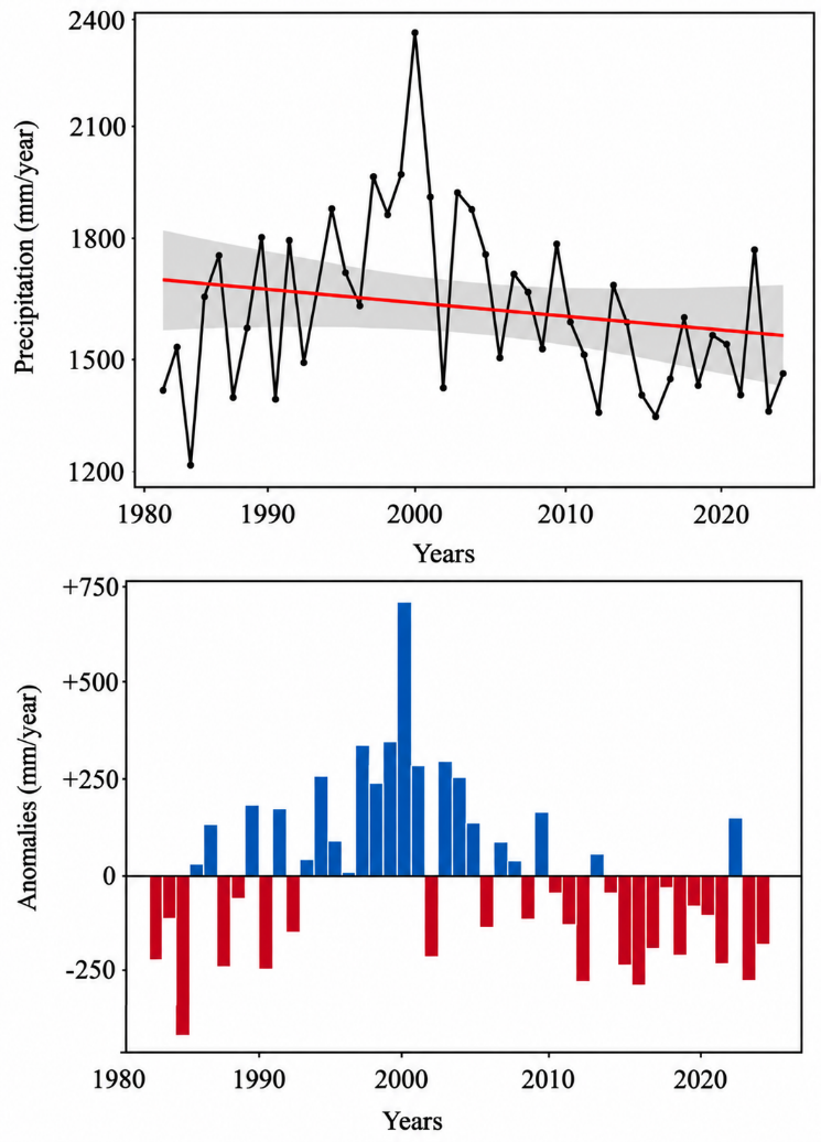
The mean annual rainfall recorded in the Mbangassina municipality during the 1981–2025 period was estimated at 1560 ± 144 mm (Figure 2). The lowest annual rainfall total (1257 mm/year) was observed in 1989, whereas the highest value (1869 mm/year) was recorded in 1999. This evolution suggests that the municipality is not only experiencing an overall declining tendency in rainfall but also substantial interannual variability in precipitation. Such variability may affect seasonal agricultural calendars and potentially influence farming activities.
Figure 2. Temporal variation and anomalies of precipitations in Mbangassina municipality during the 1981–2025 period
The analysis of annual rainfall anomalies revealed strong interannual variability in precipitation totals between 1981 and 2025, with an overall decreasing trend. Negative anomalies largely dominated the early 1980s, with a particularly pronounced rainfall deficit observed around 1983, reaching nearly −400 mm. Positive anomalies became more frequent during the 1990s, culminating in an exceptional peak around 1999, when the rainfall surplus exceeded +700 mm. Other important positive anomalies were recorded around 1995 (+340 mm), 1998 (+350 mm), 2001 (+290 mm), and 2003 (+250 mm).
However, after 2010, negative rainfall anomalies became increasingly frequent again, particularly during 2012, 2015, 2016, 2022, and 2024, with deficits generally ranging between −200 mm and −280 mm. These fluctuations indicate increasing rainfall instability and reinforce evidence of ongoing climatic variability within the Mbangassina municipality.
3.2 Spatial distribution of temperature and precipitation within the Mbangassina municipality
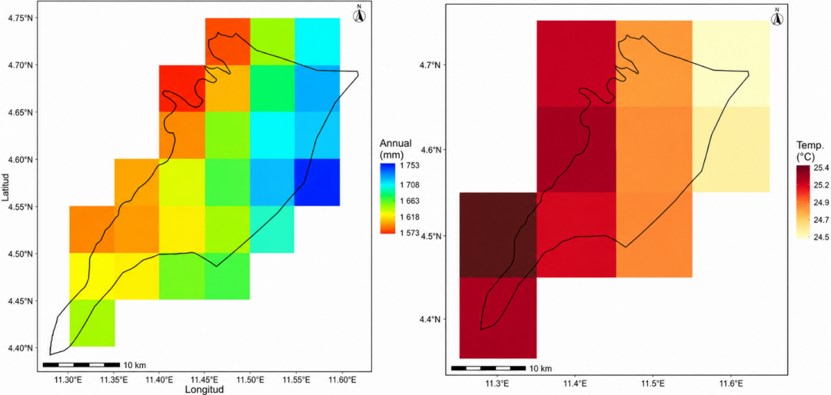
A contrasting spatial distribution of annual rainfall and temperature was observed across the Mbangassina municipality during the 1981–2025 period (Figure 3). The results indicate that these climatic parameters are not uniformly distributed throughout the municipality, highlighting substantial spatial variability in both thermal and hydrological conditions at the local scale.
Figure 3. Spatial distribution of annual rainfall and temperature in the Mbangassina municipality from 1981 to 2025
The eastern part of the municipality appears to be the wettest zone, with mean annual rainfall ranging from 1700 to 1753 mm per year. This area is also characterized by relatively lower temperatures, with mean annual values varying between 24.5 and 24.8 ℃. In contrast, the southeastern part of the municipality represents the warmest zone, with mean annual temperatures reaching approximately 25.4 ℃ and comparatively lower annual rainfall totals ranging from 1573 to 1618 mm.
These spatial differences highlight the heterogeneous nature of climatic conditions within the Mbangassina municipality. The observed patterns may reflect the influence of local environmental factors including vegetation cover, land-use dynamics, and landscape configuration, on the spatial distribution of temperature and precipitation.
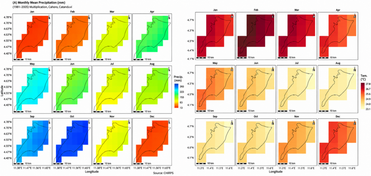
Regarding the monthly spatial variability of climatic parameters, September and October were identified as the wettest months, with monthly rainfall totals exceeding 300 mm. In contrast, December and January with monthly rainfall total below 30 mm.
A clear seasonal correspondence between rainfall and temperature patterns was observed throughout the year. September and October, which correspond to the wettest period, were also characterized by the lowest average temperatures, ranging between 23 and 24 ℃. Conversely, January and February were the warmest months, with mean monthly temperatures varying from 26 to 28 ℃.
Both rainfall and temperature exhibited marked spatial heterogeneity across the Mbangassina municipality, indicating substantial local variability in climatic conditions (Figure 4).
Figure 4. Spatial distribution of mean monthly temperatures and precipitations in the Mbangassina municipality from 1981 to 2025
3.4 Cocoa agroforest expansion and spatial patterns of climate variability within the study area
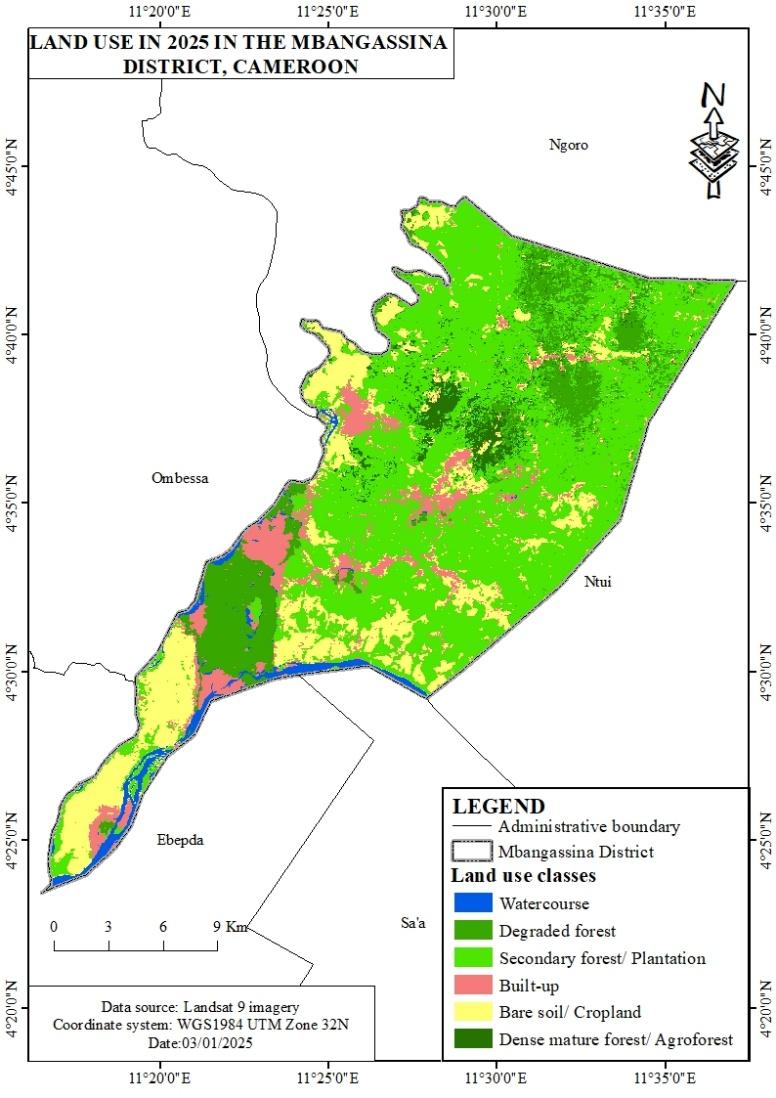
The combined analysis of land-use maps (Figure 5) and the spatial distribution of climatic parameters revealed a spatial correspondence between area characterized by different level of landscape degradation and contrasting climatic conditions within the Mbangassina municipality. The southwestern and central-western sectors of the municipality, characterized by extensive degraded forests, bare soils, cultivated lands, and anthropogenic landscapes, generally corresponded to areas characterized by higher temperatures (25.2–25.4 ℃) and the lowest annual rainfall totals (1573–1618 mm/year). In contrast, the eastern and northeastern parts of the municipality, dominated by dense forest formations and relatively preserved agroforestry systems, appeared wetter, with mean annual rainfall ranging from 1700 to 1753 mm/year and lower temperatures varying between 24.5 and 24.8 ℃.
Figure 5. Land-use and landscape map of the Mbangassina municipality in 2025
This spatial configuration indicates that areas characterized by greater the most anthropogenic disturbance and landscape degradation coincide with warmer and comparatively drier climatic condition. The maps further indicate that areas undergoing intense agricultural and cocoa agroforest expansion coincide with landscapes characterized by strong forest fragmentation. These patterns may reflect differences in vegetation cover and land-use characteristics across the municipality. However, the present study does not allow us to establish a direct causal relationship between forest degradation and rainfall decline.
Overall, the spatial distribution of climatic conditions within the Mbangassina municipality appears to be associated with vegetation cover status and the intensity of anthropogenic pressures exerted on forest landscapes.
4.1 Climate variability within the Mbangassina municipality
Climate change is now recognized as a global phenomenon affecting both natural ecosystems and human activities worldwide. The findings of the present study confirm previous reports describing a progressive increase in temperature associated with a decline in precipitation over time across many regions of the world [15]. In the Mbangassina municipality, mean annual temperature increased from 24.37 ℃ in 1981 to 25.66 ℃ in 2025. Furthermore, the post-2000 period was predominantly characterized by temperatures exceeding 25 ℃, indicating a progressive shift toward warmer climatic conditions and confirming the strengthening of the regional warming signal already highlighted in global climate assessments [16]. This warming trend is closely linked to increasing GHGs emissions resulting from industrialization and anthropogenic activities worldwide [2]. Most recent years recorded temperatures above the long-term climatic average, reflecting a persistent modification of local climatic conditions. Such changes may also be associated with the progressive degradation of natural landscapes, which normally contribute to local climate regulation through evapotranspiration and vegetation cover. Similar trends have been reported in Cameroon, where mean annual temperatures increased by nearly 1 ℃ during the 20th century due to increasing anthropogenic pressure and land-use changes [17]. According to Ngoukwa et al. [18], climate projections under the RCP4.5 scenario suggest that temperatures in Cameroon will continue to rise if mitigation measures are not effectively implemented. This warming trend is also expected to be accompanied by decreasing precipitation, with direct consequences for agricultural activities that constitute the primary source of livelihood for local populations in Mbangassina [11].
In contrast to temperature, rainfall patterns generally exhibited a declining trend, with annual precipitation decreasing from approximately 1702 mm in 1981 to 1472 mm in 2025. Similar rainfall deficits have previously been reported across Cameroon by Sighomnou [19], who identified the 1971–2000 period as one of significant rainfall decline nationwide. The reduction in precipitation observed in the present study may be spatially associated with increasing deforestation and forest degradation within the area. Indeed, tropical deforestation has been shown to reduce atmospheric moisture recycling and contribute to drier climatic conditions [4]. This pattern may be considered in the context of the intensive forest exploitation reported for the study area during the 1980s and 1990s.
In addition, the alternation between extremely wet and extremely dry years highlights strong instability in the annual rainfall regime. Excessively wet years may create unfavourable conditions for cocoa farmers, particularly during post-harvest processing, as high atmospheric humidity reduces drying efficiency and when high atmospheric humidity can reduce drying efficiency. Conversely, rainfall-deficit years may facilitate cocoa drying processes but simultaneously expose plantations to water stress conditions that could negatively affect productivity.
4.2 Spatial distribution of climate within the Mbangassina municipality
The spatial mapping of rainfall and temperature revealed marked climatic heterogeneity within the Mbangassina municipality. Eastern areas appeared wetter and relatively cooler, whereas southwestern sectors were characterized by higher temperatures and lower rainfall amounts. This spatial variability may be explained by the interaction of several environmental factors, including vegetation cover, local topography, and the intensity of anthropogenic activities. In humid tropical environments, dense forest cover generally contributes to maintaining moderate temperatures through shading effects and evapotranspiration processes while simultaneously promoting atmospheric moisture recycling [4]. The results obtained in this study are consistent with previous findings in Central Africa showing that local climatic variability tends to become more pronounced in landscapes affected by strong human pressure and forest fragmentation [5]. The observed differences between wetter and cooler sectors and warmer and drier areas, were spatially associated with differences in the degree of anthropogenic transformation. Wen et al. [20] further emphasized that landscape heterogeneity constitutes a major driver of spatial climatic differentiation, particularly within agroforestry transition zones. Consequently, the current distribution of temperature and precipitation within the Mbangassina municipality may reflect ongoing transformations of forest and agricultural landscapes associated with cocoa agroforest expansion.
4.3 Monthly climatic evolution
The monthly evolution of rainfall and temperature revealed two distinct rainfall peaks characteristic of a bimodal rainfall regime. The first and relatively weaker rainfall peak occurred between March and May, with monthly precipitation averaging around 200 mm, corresponding to the short rainy season. The second and more intense rainfall peak occurred during September and October, when precipitation exceeded 300 mm per month, marking the long rainy season. These two rainy periods were separated by two dry seasons: a long dry season extending approximately from November to March and a shorter dry season occurring between June and August. These findings are consistent with the existence of four unevenly distributed seasons typical of the sub-equatorial Guinean climate reported in previous studies conducted in the region [11, 21].
At the national scale, both the Institute of Agricultural Research for Development (IRAD) and the National Observatory on Climate Change (NOCC) classify this area within Cameroon’s bimodal rainfall agroecological zone characterized by an equatorial climate with four distinct seasons.
4.4 Spatial association between climate variability and cocoa agroforest expansion within Mbangassina municipality
The results of this study suggest a spatial association between climate variability and cocoa agroforest expansion within the Mbangassina municipality. Areas characterized by wetter and relatively cooler conditions generally corresponded to zones where cocoa cultivation appeared more developed. This pattern is consistent with the climatic requirements of cocoa (Theobroma cacao L.), which perfoms best under relatively stable conditions such as regular rainfall and moderate temperatures that support vegetative growth, flowering, and pod production [7, 22]. Areas receiving abundant rainfall therefore provide better water availability necessary for sustaining cocoa productivity. Conversely, areas characterized by higher temperatures and rainfall deficits appeared less favourable for cocoa expansion. Excessive warming combined with declining precipitation can induce water stress, reduce soil fertility, and negatively affect agricultural yields [8]. These climatic constraints become particularly severe in landscapes where deforestation and forest opening intensify local warming effects. Several studies conducted in West and Central Africa have demonstrated that forest degradation around cocoa-producing basins contributes to local microclimatic disturbances and increases plantation vulnerability to climate change [4, 5].
Furthermore, cocoa expansion itself may corresponded with local climatic conditions depending on management practices. Cocoa agroforestry systems integrating diverse shade tree species contribute to maintaining higher relative humidity, reducing extreme temperatures, and improving ecological resilience [10]. In contrast, simplified cocoa systems with low tree cover favour higher ground temperatures and reduce the hydrological regulation capacity of landscapes [23].
Although cocoa agroforestry systems involve some degree of forest transformation, they may still represent valuable alternatives for climate mitigation because they partially mimic the ecological functions of natural forests. By maintaining tree cover and enhancing carbon storage, agroforestry systems can contribute to local and regional climate regulation [22, 23]. Consequently, cocoa cultivation, which represents the dominant economic activity in the Mbangassina municipality, may play a significant role in climate change mitigation at local, national, and international levels when managed under sustainable agroforestry practices.
4.5 Study limitations and perspectives
Despite the valuable insights provided by this study, certain limitations should be considered when interpreting the results. The analyses were primarily based on remotely sensed climatic data and spatial associations, which remain insufficient to demonstrate direct causal links between land-use change and local climatic dynamics. Moreover, local climate variability may also be influenced by additional environmental factors, including topography, atmospheric circulation patterns, and soil moisture conditions. Also, the resulting maps should be interpreted as generalized spatial patterns rather than direct measurements of fine-scale microclimatic conditions. The spatial resolution of the Landsat imagery may also limit the detection and characterization of smallholder cocoa agroforestry systems. These limitations may influence the interpretation of fine-scale spatial relationships between climate and land use. Future research combining ground-based meteorological measurements, carbon balance assessments, and socio-economic investigations would provide a more comprehensive understanding of the interactions between climate variability, landscape transformation, and cocoa agroforestry systems.
The results of this study confirmed the existence of significant climate variability within the Mbangassina municipality over the 1981–2025 period. The observed trends revealed a progressive increase in temperature associated with a general decline and increasing irregularity in rainfall over time. The study also demonstrated that both temperature and precipitation are not uniformly distributed across the municipality, even though the entire area belongs to the same bimodal rainfall forest agroecological zone. The spatial heterogeneity observed in climatic conditions appears was associated with differences in vegetation cover, landscape transformation and anthropogenic pressure. The combined analysis of land-use dynamics and climatic spatialization further highlighted a strong spatial relationship between highly degraded areas and warmer, drier climatic conditions.
Based on these findings, we now emphasize the importance of maintaining shade-tree diversity, improving soil and water conservation, maintaining tree cover and promoting diversified cocoa agroforestry systems. Given the socio-economic importance of cocoa cultivation in the study area, understanding the implications of climate variability on cocoa productivity and agroforestry sustainability has become increasingly important. Future research should therefore focus on assessing the impacts of climate change on cocoa production systems, farmers’ vulnerability. For local authorities and agricultural extension services, we highlight the potential use of the spatial information generated by the study to identify areas requiring priority climate-adaptation and forest-conservation interventions. Particular attention should also be given to the identification and promotion of climate-resilient agroforestry practices capable of strengthening both environmental sustainability and the resilience of rural livelihoods in the Mbangassina municipality.
[1] Scheffers, B.R., De Meester, L., Bridge, T.C.L., et al. (2016). The broad footprint of climate change from genes to biomes to people. Science, 354(6313): aaf7671. https://doi.org/10.1126/science.aaf7671
[2] Edenhofer, O., Pichs-Madruga, R., Sokona, Y., et al. (2014). Summary for policymakers. In Climate Change 2014: Mitigation of Climate Change. https://pure.iiasa.ac.at/id/eprint/11125/.
[3] Tsalefac, M., Hiol Hiol, F., Mahé, G., et al. (2015). Climat de l'Afrique centrale: Passé, présent et futur. In Les Forêts du Bassin du Congo-Forêts et changements climatiques. Weyrich Edition, Neufchâteau, pp. 37-52. https://www.documentation.ird.fr/hor/fdi:010093722.
[4] Laurance, W.F., Camargo, J.L., Luizão, R.C., et al. (2011). The fate of Amazonian forest fragments: A 32-year investigation. Biological Conservation, 144(1): 56-67. https://doi.org/10.1016/j.biocon.2010.09.021
[5] Malhi, S.G., Kaur, M., Kaushik, P. (2021). Impact of climate change on agriculture and its mitigation strategies: A review. Sustainability, 13(3): 1318. https://doi.org/10.3390/su13031318
[6] Schroth, G., Laderach, P., Martinez-Valle, I.A., Bunn, C., Lassogne, L. (2016). Vulnerability to climate change of cocoa in West Africa: Patterns, opportunities and limits to adaptation. Science of the Total Environment, 556: 231-241. https://doi.org/10.1016/j.scitotenv.2016.03.024
[7] Oyekale, A.S. (2021). Climate change adaptation and cocoa farm rehabilitation behaviour in Ahafo Ano North District of Ashanti region, Ghana. Open Agriculture, 6(1): 263-275. https://doi.org/10.1515/opag-2020-0191
[8] Wang, W., Yapo, C.K.L.C. (2022). Impact of climate change on West Africa cocoa yield: Evidence from Cote D'Ivoire. International Journal of Economics, Commerce and Management, 10(1): 163-177.
[9] Hairiah, K., Dewi, S., Agus, F., et al. (2011). Measuring Carbon Stocks Across Land Use Systems: A Manual. Bogor, Indonesia. World Agroforestry Centre (ICRAF), SEA Regional Office, pp. 1-121.
[10] Akoutou, M.E., Ndo, E.G.D., Nomo, L.B., Ambang, Z., Manga, F.B., Cilas, C. (2022). Tree diversity and shade rate in complex cocoa-based agroforests affect citrus foot rot disease. Basic and Applied Ecology, 64: 134-146. https://doi.org/10.1016/j.baae.2022.08.003
[11] PCD. (2015). Plan Communal de Développement de l'Arrondissement de Mbangassina. Commune de Mbangassina, pp. 1-153. https://docslib.org/doc/4974688/plan-communal-de-d%C3%A9veloppement-de-mbangassina#google_vignette.
[12] Arguez, A., Vose, R.S. (2011). The definition of the standard WMO climate normal: The key to deriving alternative climate normals. Bulletin of the American Meteorological Society, 92(6): 699-704. https://doi.org/10.1175/2010BAMS2955.1
[13] Ningrum, W., Santoso, H., Marganingrum, D., Narulita, I., Rusydi, A.F., Purwoarminta, A. (2025). Comparative analysis of CHIRPS, TRMM, and GSMaP rainfall data on Pari Island. IOP Conference Series: Earth and Environmental Sciences, 1462(1): 012062. https://doi.org/10.1088/1755-1315/1462/1/012062
[14] Chimi, D.C., Tanougong, A.D., Owona, A.J.M., et al. (2025). Determinants of cocoa productivity and vulnerability to climate change in Central Cameroon: An in-depth analysis of farmers' perspectives. Green and Low-Carbon Economy, 4(1): 76-84. https://doi.org/10.47852/bonviewGLCE52024143
[15] Olsson, L., Opondo, M., Tschakert, P., et al. (2014). Livelihoods and poverty. In Climate Change 2014: Impacts, Adaptation, and Vulnerability. Part A: Global and Sectoral Aspects. pp. 793-832. https://research-repository.uwa.edu.au/en/publications/chapter-13-livelihoods-and-poverty/?sortBy=alphabetically.
[16] Groupe d'experts intergouvernemental sur l'évolution du climat. (2022). Global warming of 1.5 ℃: An IPCC special report on impacts of global warming of 1.5 ℃ Above pre-industrial levels and related global greenhouse gas emission pathways, in the context of strengthening the global response to the threat of climate change, sustainable development, and efforts to eradicate poverty. Cambridge University Press.
[17] MINEPDED. (2015). Seconde communication nationale sur les changements climatiques du Cameroun. Yaoundé, Cameroon, p. 214. https://unfccc.int/sites/default/files/resource/cmrnc2.pdf.
[18] Ngoukwa, G., Chimi, D.C., Kabelong, B.L.P.R., et al. (2023). Perception and adaptation strategies of forest dwellers to climate variability in the tropical rainforest in eastern Cameroon: The case of the inhabitants of the Belabo-Diang Communal Forest. Heliyon, 9: e15544. https://doi.org/10.1016/j.heliyon.2023.e15544
[19] Sighomnou, D. (2004). Analyse et redéfinition des régimes climatiques et hydrologiques du Cameroun: Perspectives d'évolution des ressources en eau. Thèse Doctorat d'Etat en Sciences de la Terre, Université de Yaoundé, pp. 1-286. https://horizon.documentation.ird.fr/exl-doc/pleins_textes/divers15-03/010063375.pdf.
[20] Wen, X., Zhen, L., Xiao, Y. (2024). Exploring dynamic spatiotemporal relationships among multiple ecosystem systems to identify priority restoration areas: A case study in the Chinese Loess Plateau. Environmental Research Communications, 6(11): 111001. https://doi.org/10.1088/2515-7620/ad8b17
[21] Agbongiarhuoyi, A.E. (2020). Impact of personal characteristics of farmers on cocoa yields: Case of Centre Region, Mbangassina Municipality, Cameroon. Pelita Perkebunan, 36(2): 190-202. http://doi.org/10.22302/iccri.jur.pelitaperkebunan.v36i2.441
[22] Gloy, N., Chemura, A., Tchindjang, M., Gornott, C. (2025). Mapping climate change impacts on cocoa agroforestry systems in Cameroon to mitigate future deforestation. Agronomy for Sustainable Development, 45: 66. https://doi.org/10.1007/s13593-025-01042-1
[23] Nyako, C.M., Kabelong, B.L.P.R., Libalah, B.M., et al. (2025). Woody biodiversity conservation and provision of ecosystem services in a traditional cocoa agroforest. Agroforestry Systems, 99: 114. https://doi.org/10.1007/s10457-025-01205-9