Hasan Basri* | Irfan Azim | Yuliagnis Transver Wijaya | Muhamad Riyadlul Jinan | Muhamad Ali | Muhammad Yusuf | Muharis Muharis | Kamarudin Kamarudin | Firdausi Nuzula | Zulkarnain Zulkarnain | Lalu Muhammad Ariadi
© 2026 The authors. This article is published by IIETA and is licensed under the CC BY 4.0 license (http://creativecommons.org/licenses/by/4.0/).
OPEN ACCESS
This study addresses the limited use of simulation-based evacuation planning in rural tourism destinations exposed to volcanic hazards and offers a novel contribution by integrating evacuation route choice, departure time, and movement speed into an Agent-Based Modeling (ABM) framework tailored to eruption scenarios. The study aims to develop an evacuation simulation using ABM in NetLogo and to analyze how route selection, evacuation timing, and evacuee speed shape evacuation outcomes in disaster-prone rural destinations. Using data from the 2021 Mt. Semeru eruption in Indonesia, the research combined demographic, geospatial, and disaster report data to build, verify, and validate a simulation model representing population movement toward evacuation points under different waiting-time and speed scenarios. The findings show that evacuation effectiveness is highly sensitive to delay and mobility: immediate evacuation increases the proportion of residents reaching safety, whereas longer waiting times, greater variation in departure time, and slower movement significantly increase the number of people who fail to evacuate, especially vulnerable groups. Practically, the study provides an evidence-based basis for disaster management through evacuation route mapping, stronger early warning systems, improved community preparedness, vulnerability mapping, and enhanced planning for officers, volunteers, and local governments to reduce future casualties and strengthen destination resilience.
disaster evacuation, volcanic eruption, Agent-Based Modeling, rural tourism destinations
Indonesia has a large rural tourism potential, luring visitors to a variety of distinct cultural and natural environments [1]. However, Indonesia is extremely vulnerable to disasters, particularly because it is located in the Ring of Fire, which is prone to seismic and volcanic activity. While volcanic events drive disaster, it is also now becoming a significant tourism segment [2]. The SDGs, particularly Goal 13, emphasise the importance of increasing resilience and adaptive capacities to these risks, including in Indonesia. This entails developing a strategy for rural tourism destinations to protect locals and visitors while ensuring the region's long-term viability as an appealing and safe destination. In this context, disaster risk management must be integrated into tourism planning [3], particularly given Indonesia's vulnerability to volcanic eruptions, earthquakes, and other disasters [4, 5].
In Indonesia, disaster management policies are encompassed in the National Medium-Term Development Plan, known as the RPJMN, which aims to mitigate disaster risk across the country. Disaster risk studies in Indonesia predominantly concentrate on tsunami and earthquake events [6], which typically result in loss of life [7]. Research on preparedness, particularly concerning volcanic eruptions affecting rural areas, remains limited. Residents' ability to evacuate is a critical factor in disaster risk reduction, particularly during volcanic crises affecting rural areas [8]. Evacuation is an essential aspect of disaster management, entailing the relocation of individuals from a designated area in response to potential threats [9, 10]. Evacuation planning is crucial for minimising casualties and property damage [11, 12]. This phenomenon was observed in Aceh and Yogyakarta in 2004 and 2006 [13, 14], as well as in 2018 on the island of Lombok, severely impacting the tourism economy [15].
A research gap exists regarding the development of evacuation preparedness methods in Indonesia, particularly in rural areas susceptible to volcanic activity. Heightened volcanic activity in certain regions necessitates implementing evacuation training as a critical component of disaster preparedness. Implementing disaster evacuation drills requires significant time, effort, and cost, posing a considerable challenge. Furthermore, emergency evacuation remains a conventional issue addressed through traditional methodologies [16]. Traditional methods are inadequate for capturing individual decision-making behaviour and potential interactions among refugees [17]. Emergency evacuation represents a multifaceted issue that encompasses the decisions of numerous individuals and is shaped by diverse factors, such as psychology, demographics, and interpersonal relationships [17-19].
Recent research has increasingly employed computer models to simulate the evacuation process, addressing the limitations of traditional methods [20]. Agent-Based Modeling (ABM) is a proposed approach recognised for its effectiveness in addressing complex system problems, including emergency evacuation [21]. Bonabeau [22] characterized ABM as a simulation method that represents a system through a set of autonomous decision-making entities, known as agents. These agents can dynamically respond to issues according to a predefined set of behavioural or functional rules [23].
Various methodologies for evacuation simulations have been suggested [24]. ABM is a frequently employed methodology. Numerous studies have utilised ABM in the context of evacuation. Zou et al. [25] performed ABM of individuals in trains and platforms at subway stations, yielding insights into the potential causes of evacuation delays. Furthermore, ABM is widely applied to natural disaster evacuation scenarios, including floods [19], tsunamis [17, 20, 26], and fires [27]. Various studies have proposed procedures for the evacuation process during volcanic eruptions. Sopha et al. [28] conducted a simulation of disaster evacuation and volunteer coordination during the 2010 eruption of Mount Merapi. Cova and Johnson [29] conducted an evacuation simulation for the 2010 Mount Merapi eruption. This study presents a framework for developing volcanic evacuation simulations by integrating ABM and GIS. AL Ghazo and Kumar [30] conducted a study to simulate the actual evacuation distance approach in the event of a Mount Merapi eruption. A study by Wang et al. [21] was conducted to simulate evacuation utilising multimodal transportation in tsunami scenarios using ABM.
This article addresses a clear research problem: rural tourism destinations in volcanic hazard zones remain highly vulnerable during eruptions, yet evacuation planning remains limited, costly, and often relies on conventional approaches that cannot adequately capture human decision-making and movement dynamics. As a result, destination managers and policymakers lack practical, evidence-based tools to anticipate how residents evacuate under different conditions of time, speed, and route choice. The study, therefore, seeks to fill both a practical and scientific gap by developing an agent-based simulation that can model evacuation behaviour more realistically and support more effective disaster risk management in vulnerable rural destinations.
This study employs ABM to develop realistic disaster-evacuation scenarios to enhance community preparedness in rural tourism destinations. The simulation utilising ABM is designed to assist tourism managers in comprehending the dynamics of evacuation, encompassing optimal routes, timing, and speeds during natural disasters, such as future volcanic eruptions.
2.1 Disaster risk management toward sustainable rural destinations
Disaster risk management in rural tourism destinations is critical to ensuring their resilience and sustainability. Rural areas, which have geographic characteristics that make them prone to disasters such as earthquakes, floods, volcanic eruptions, and landslides, require integrated mitigation measures to reduce the risk of loss for local populations and tourists. People's emergency evacuation is an important aspect of catastrophe risk management in tourism destinations [29]. Evacuation is the act of removing individuals from a specific location owing to the fear of impending danger [9, 10]. During an eruption, the population's ability to leave plays a significant role in minimising danger in rural areas [8]. This involves transporting individuals to safer regions and then returning them securely. Planned and communicated evacuations are extremely beneficial in reducing casualties, such as those that occurred during the 2018 evacuation that shut down national tourism destinations on the island of Lombok [15].
Furthermore, catastrophe risk management in destinations necessitates collaboration among multiple stakeholders [3], including governments, non-governmental organisations, and the commercial sector. The government can provide policy support through disaster management guidance and training for tourism actors, as well as supporting infrastructure such as evacuation routes and early warning systems. Furthermore, engaging the private sector to finance mitigation and post-disaster recovery efforts might help villages respond to hazards more swiftly and efficiently. The use of data-driven technology, such as mapping disaster-prone areas and conducting risk analyses, helps destination managers detect potential hazards more accurately, allowing them to design appropriate mitigation plans. Comprehensive risk management in rural tourism destinations will eventually boost tourist appeal and security [31], as well as destination competitiveness in the long run.
2.2 Evacuating disaster in rural destinations
Effective evacuation planning in specific locations is critical [32] and has resulted in significant lives saved [33]. Lim et al. [18] stated that evacuation choices can be taken by both the government and individuals/households. The authorities' decision is more complex because it considers hazard detection, risk identification, evacuation shelters, transportation modes, routes, and evacuation centres. In rural areas, the decisions of individuals, households, and company managers are viewed as critical to comprehending the process. Limited resources, such as human resources and transport infrastructure, leave rural areas vulnerable to disasters [34, 35]. The cooperation of the government, tourism industry monitors, and residents can help ensure a safe evacuation process. Although humans cannot prevent disasters, they can carry out prevention measures [36]. As a result, it is vital to develop a simulation technique that models human behaviour in evacuation operations [37] in rural areas, as it provides accurate forecasts and improves problem-solving. Policymakers can anticipate evacuation travel requests, vehicle allocation, and traffic patterns to ensure that selected shelters are reached as soon as feasible [18].
However, various issues frequently arise during the evacuation of individuals in remote areas. First, catastrophic eruptions are unpredictable [24]. Several catastrophic disasters, including tsunamis, earthquakes, and mountain eruptions in prospective tourism locations, have resulted in significant material and human life losses. The 2021 Mt. Semeru eruption claimed lives due to its abrupt onset, leaving the town unprepared for evacuation. Second, the residents' diverse evacuation behaviours hinder the evacuation procedure. Some residents are hesitant to evacuate due to a low perception of threat and a strong belief in cultural leaders who refuse to evacuate [28]. Third, limitations in transit capacity, mileage, evacuation post capacity, and road capacity must be considered. This type of impediment is typical of education in rural tourism sites with inadequate resources. When the number of evacuees exceeds the road's capacity, congestion occurs, slowing their ability to reach shelters [28]. To decrease complications during the emergency evacuation procedure, it is critical to understand when and how to leave [28].
Residents in impacted rural areas, particularly in the red zone, have a limited time to escape. As a result, the simulation relies heavily on the evacuation's starting time. In addition to the start time of the evacuation, when it occurs, transportation planning for evacuation has a significant impact on the success of efforts to reduce the risk of casualties. Inadequate transportation in rural areas forces some people to walk, leaving them exposed to delays [24]. Disaster response will be slow in communities with children and the elderly due to a lack of capacity and resources [21]. To facilitate mobility, determining a good evacuation route is critical. Evacuation routes in rural areas can be utilised to mobilise the population swiftly and efficiently, ensuring they arrive at the evacuation post on time.
This study is justified by a clear weakness in prior research. Although disaster studies in Indonesia have expanded, most have focused on earthquakes and tsunamis, while evacuation preparedness for volcanic eruptions in rural destinations remains underexplored. Existing approaches also tend to rely on conventional drills and static planning tools, which are costly, time-intensive, and limited in their ability to represent individual decision-making, behavioural variation, and interaction during emergencies. This leaves an important gap in both theory and practice, particularly for rural tourism destinations that face high volcanic risk yet have limited resources. Addressing this gap through an agent-based simulation approach is therefore necessary to produce a more realistic, flexible, and policy-relevant understanding of evacuation dynamics.
3.1 Study site
This study examines the December 2021 eruption of Mt. Semeru, Indonesia, which resulted in a lava flood, explosive material ejection, and ashfall in Lumajang Regency. Mt. Semeru, the tallest mountain on the island of Java, has the highest peak, Mahameru, at 3,676 meters above sea level. Mt. Semeru is located within the administrative boundaries of Malang Regency and Lumajang Regency in East Java Province. The eruption history of Mt. Semeru commenced on November 8, 1818. Since 1967, Mt. Semeru has exhibited continuous activity, primarily centred in the Jonggring Seloko crater, located southeast of the Mahameru summit. The most significant eruption of Mt. Semeru that generated hot clouds occurred in 1963, 1968, 1977, and 2021 (East Java Regional Disaster Management Agency (BPBD), 2022).
Technically, the simulation was developed in NetLogo 6.3 and supported by QGIS for processing geospatial data from Pronojiwo and Candipuro Districts, including road networks, population distribution, and 16 evacuation points. The model represented one agent as 10 residents and tested evacuation behaviour using waiting time (τ), departure-time variation (σ), and speed scenarios from 0.5 to 1.5 m/s. The A* algorithm was selected because it efficiently identifies the shortest path from each agent’s location to the nearest shelter in a road network. However, its limitations stem from simplified assumptions, as it cannot fully capture traffic dynamics, topography, and heterogeneous evacuation behaviour.
At 14:47 WIB (Western Indonesian Time) during the 2021 eruption of Mt. Semeru, the Volcano Observation Post (PPGA) reported a tremor with a maximum amplitude of 20 millimetres, noting the absence of lava flow or hot cloud fall. At 14:50 WIB, the community and miners active in the watershed were advised to evacuate and refrain from conducting activities in the river. At 15:10 WIB, PPGA reported a clear observation of volcanic ash from the hot cloud fall, accompanied by a noticeable sulfur odor. At 15:30 WIB, the Lumajang BPBD evacuation team proceeded to the sectoral areas of Candipuro and Pronojiwo to perform monitoring and evacuation activities (Regional Disaster Management Agency (BPBD) Lumajang, 2021).
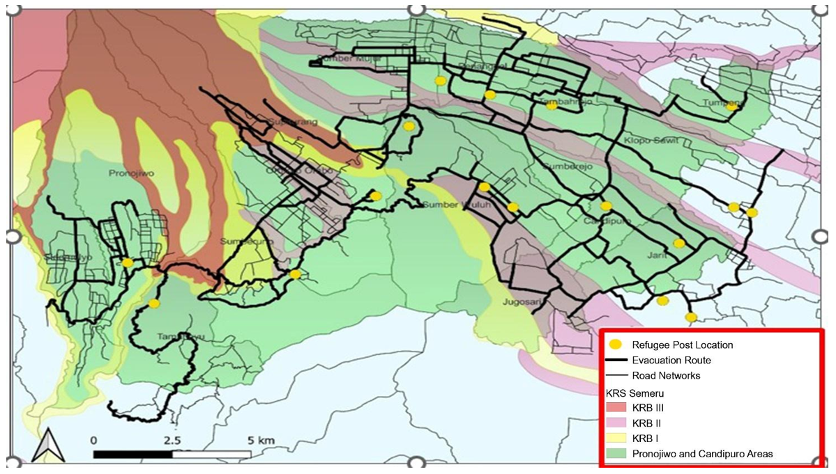
A report from BPBD indicated that the death toll from the 2021 eruption reached 51 individuals, along with several injured residents. BPBD reported that over 9,000 residents have evacuated to various evacuation points in Lumajang Regency. The eruption of Mt. Semeru has damaged residential areas, infrastructure, social dynamics, and economic conditions, disrupting public activities and services in the vicinity of the mountain. The study selected Candipuro District and Pronojiwo District as its focus areas. According to Figure 1, the two sub-districts are the regions most impacted by the eruption of Mt. Semeru.
Figure 1. Simulation areas
3.2 Data sources
ABM is a methodological approach that explicitly represents individuals (e.g., humans, animals, and cells) and their interactions with one another and their environment [38]. ABM is a simulation technique that represents a system as a set of autonomous decision-making agents [22]. ABM employs a bottom-up methodology to analyse how individual behavioural interactions influence system behaviour through computer-based simulations.
The report on the 2021 eruption of Mt. Semeru serves as the foundation for constructing simulations tailored to the actual circumstances. It commences with damage assessments, the incident's timing, the quantity of refugees, and other relevant details. The report was sourced from documents by BNPB and BPBD Lumajang Regency. Furthermore, demographic statistics are sourced from the Central Statistics Agency (BPS). Geospatial data and information are sourced from the Geospatial Information Agency (BIG). The simulation will be developed utilising NetLogo software version 6.3 and Quantum GIS (QGIS). NetLogo is a software program initially developed by Wilensky in 1999, renowned for its frequent application in ABM and its user-friendly interface. QGIS is an open-source GIS program compatible with multiple operating systems. QGIS facilitates the straightforward visualisation of GIS data.
3.2.1 Creating simulation areas
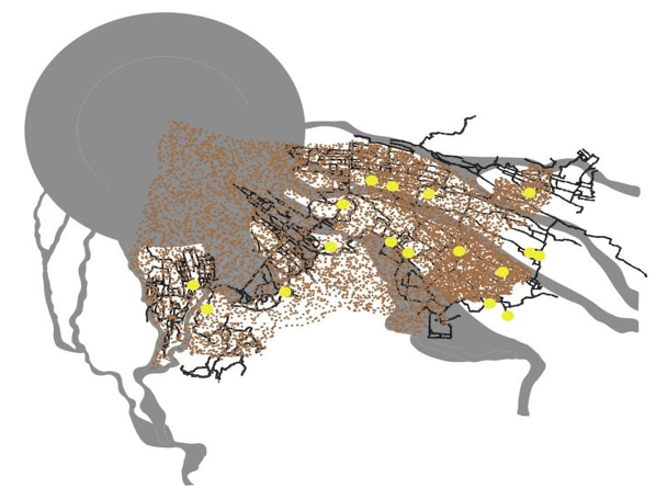
The environment is the agent's location. This simulation utilizes GIS data from the Pronojiwo and Candipuro Districts in Lumajang Regency. The elements constituting the environment include the transportation network, population distribution, and the placement of evacuation sites. Figure 2 depicts the environment designated for the simulation. The road network is designated as black, serving as an evacuation route for refugees. It is presumed that all refugee agents adhere to the established road network and proceed to the nearest evacuation point. The evacuation point is represented by a yellow circle. The research study identifies 16 evacuation points, presuming that each evacuation centre has limitless capacity.
Figure 2. Simulation process
3.2.2 Agent decision
In practical scenarios, individuals react to threats in varying ways, influenced by their knowledge, educational background, physical condition, and prior disaster experience. In this investigation, it was presumed that all agents experienced harm uniformly. The simulation exclusively examines the repercussions of the eruption, omitting the effects resulting from debris flows and traffic incidents during an emergency. They select the location, route, mode of transportation, and evacuation speed irrespective of their familiarity with the area.
3.2.3 Short route
The road network model indicates that, to assess the impact of agents during the evacuation process, local resident agents are assumed to know the direction and shortest route to the nearest evacuation site from their initial locations at the start of the simulation. The closest evacuation site for each agent and the most efficient route were identified utilising the A* algorithm [17]. The A* algorithm is a search method employed to determine the shortest path between a starting point and a destination. This assertion is similarly relevant in the context of a study concerning tsunami evacuation in Aceh, Indonesia. Furthermore, each agent departed from his residence and proceeded to the adjacent lane. Upon reaching the nearest road, the agent evacuates.
3.2.4 Evacuation waiting time
The timing of residents' evacuation initiation is a critical factor in the disaster evacuation process. The duration of evacuation significantly influences traffic congestion during such events. The decision-making process regarding evacuation is complex and significantly influenced by psychological preparedness [9]. An accurate description of emergency response time is essential for the realistic simulation of an evacuation event. Furthermore, early evacuation is anticipated to mitigate human damage. To account for the complexity and variability of human behaviour and preferences regarding departure times during evacuations, departure time distributions can be used to capture all potential behaviours within the population. This approach requires specifying suitable distributional parameters. Wang et al. [17] utilised the Rayleigh distribution to model departure times in evacuation scenarios. The Rayleigh distribution, introduced by Rayleigh in 1880, is a specific instance of the Weibull distribution. These distributions are essential for modelling and analysing lifetime data, including project effort loading, survival and reliability analysis, communication theory, physical sciences, technology, diagnostic imaging, applied statistics, and clinical research. The Rayleigh distribution employed has scale parameters σ defined as follows:
$F(t)=\{0,0<t>\tau 1-e-(t-\tau) 2 /(2 \sigma 2), t>\tau$
where:
$t$: the time after the evacuation order is given.
$\tau$: the minimum preparation time for evacuation. $\tau$ (waiting time) is the time it takes for residents to start evacuating.
$\sigma$: standard deviation of departure times, reflecting the variability in evacuation start times.
3.2.5 Evacuation speed
Evacuation speed is influenced by the population's age demographics. During an eruption, residents proceed to the evacuation post. Researchers posited that the eruption caused no damage or incidents. The evacuation speed exhibits a normal distribution with variations, and this speed is determined accordingly. For the pedestrian agent, we established multiple speed scenarios, specifically for average speeds of 0.5 m/s, 1 m/s, and 1.5 m/s, with variations of 0.1 m/s, 0.2 m/s, and 0.4 m/s. Agents maintain a constant running speed, unaffected by terrain or other agents' speed.
3.2.6 Population
The population of Pronojiwo and Candipuro Districts serves as the initial location of agents in a model derived from BPS data pertaining to Lumajang Regency. To account for the computing load, one agent corresponds to 10 residents, resulting in a total of 10,899 agents. The demographic distribution is as follows: 7.49% aged 5-9 years, 7.89% aged 10-14 years, 52.02% aged 15-49 years, 18.12% aged 50-64 years, and 8.24% aged 65 years and older (Central Bureau of Statistics (BPS), 2022).
4.1 Model implementation of NetLogo
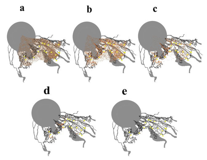
This simulation aims to provide an overview of the evacuation process during the 2021 Mt. Semeru eruption. The simulation provides an overview of the evacuation process, focusing on the evacuation route, evacuation time, and walking speed. This model provides several insights. This model primarily outputs the distribution of evacuation times and the percentage of the population that has evacuated, contingent on the availability of hazard information. This simulation serves as a tool for evaluation and prediction in disaster risk management. Policymakers can implement various measures to enhance preparedness before disasters occur. Figure 3 illustrates the results of the implementation. The interface section presents the simulated environment in which the agent operates. Additionally, users can input several parameters, including the percentage of agents to be utilised, the speed of the refugees, τ (minimum preparation time for evacuation), and σ (distribution of departure time). A graph illustrates the percentage of the population that has been evacuated, as shown in the simulation results. In this simulation, each second corresponds to one second in reality.
Figure 3. Societal moves within evacuation
The agent remaining brown indicates that evacuation has not occurred. In Figure 2(b), the agent's evacuation is indicated by a change in colour to orange. Figure 2(c) illustrates the presence of a traffic jam or a congregation of agents engaged in evacuation. The four-dimensional image indicates that most agents have conducted simulations. All agents depicted in Figure 2(e) have successfully completed the evacuation, as indicated by the lack of any agent in the process of evacuating.
4.1.1 Evacuation route
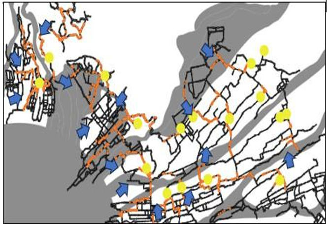
An evacuation route is a designated path utilised for the swift and direct relocation of individuals away from potential threats or hazardous events. In this simulation, local evacuation agents are assumed to know the shortest direction and path to the nearest evacuation point from their initial locations at the start. The evacuation route is determined solely by the shortest path identified during the simulation, disregarding the area's topographic conditions and the population's state. Figure 4 illustrates the evacuation routes selected by the residents. This simulation process illustrates population movement. Certain lanes experience congestion because residents choose the same shortest route. Evacuation routes were developed to provide an overview and alternatives for establishing them.
One strategy to enhance community preparedness involves Town Watching activities. Town watching is an activity established in Japan in the 1970s, serving as a participatory tool for community development, with the objective of creating a community that is responsive to natural disasters [39]. This activity involves observing the environment, taking notes, and documenting findings with a camera. This activity is driven by residents or communities that possess a comprehensive understanding of their environment and engage all strata of local society. Monitoring activities have been effectively implemented in several disaster-prone regions of Indonesia, including the Mount Kelud area, Aceh [40], and the Mt. Semeru area [39]. Connecting the simulation with actual preparedness in the field allows policymakers to gain a clearer understanding of the community's evacuation process. The government can implement policies to prepare for eruption-related disaster mitigation.
This study demonstrates the applicability of ABM in the disaster evacuation process. The previously generated simulation offers an overview of the evacuation process. This is valuable for assessing disaster risk management. Policy interventions typically target the behaviour of individuals, businesses, or households, rather than addressing systemic issues; ABM facilitates a comprehensive representation of these mechanisms [41, 42]. ABM effectively captures real-world behaviour, rendering it appropriate for policy applications.
An alternative evacuation route can be established to assess the shortest path and population movement during an eruption, serving as a policy foundation based on simulations utilising ABM (Figure 5). The designated evacuation route is the dark black lane. The routes are organised in an interwoven manner among the evacuation posts, ensuring their integration. This serves as a foundational element in establishing the logistics route assigned to refugees. Furthermore, the map enables policymakers and evacuation officers to delineate the primary routes utilised during an eruption. Transportation engineering and road repairs serve as a method of preparedness. While the map below is not yet ideal, it demonstrates that ABM simulation is feasible.
Figure 4. Evacuation route based on simulation
Figure 5. Timing of delay scenario of evacuation
4.1.2 Evacuation waiting time
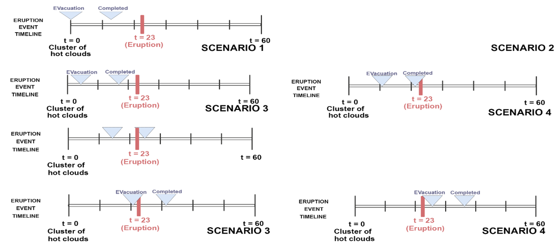
As discussed, τ (waiting time) is one of the parameters that affects the agent's decision-making time. No agent evacuates when t < τ. Figure 6 shows the timeline of the eruption of Mt. Semeru and the scenario-based delay time in this study. Based on the eruption of Mt. Semeru, residents are expected to evacuate at 14:47 WIB. Then the peak erupted 23 minutes later, at 15:10 WIB. Seven scenarios were tested, starting with scenario 1 of τ = 0 minutes, i.e., immediate evacuation. In scenario 2, the agent starts their evacuation process at τ = 5. Scenarios 3 through 6 assume a delay time τ = 10, 15, 20, and 25.
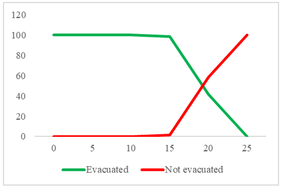
The simulation results indicate that evacuation time is a critical factor. In this simulation, if all residents adopt the adults' speed and a departure-time variance of 1.65 minutes, the required time is only 9 minutes. However, if the duration before evacuation begins is extended, it will necessitate community-wide emergency evacuations during the eruption. Figure 7 illustrates the percentage of refugees across six simulated scenarios, maintaining constant scale parameters (σ = 1.65) and utilising the adult speed for the entire population. The number of refugees decreases as the delay or preparation time increases. In scenarios 1-3, agents evacuate immediately, resulting in a 100% evacuation rate. This percentage decreases by approximately 1.39% in scenario 4. In scenario 5, approximately 58.3% of residents chose not to evacuate. In the final scenario, the agent initiates the evacuation at the moment the eruption takes place.
Figure 6. Percentage of evacuated population and people who do not
Figure 7. Percentage of people who do not evacuate themselves during the eruption
This aligns with the study by Liu et al. [34], which simulated a tsunami scenario. The number of refugees decreased as the delay or preparation time increased. In the scenario where the agent executes an immediate evacuation, the total percentage of evacuees is 95.9%. This figure decreases by approximately 14–15% when the agent initiates the evacuation at the point the tsunami reaches its maximum wave height. Tan et al. [27] indicated that early evacuation can reduce human losses. The evacuation time, particularly for the red zone, is limited. The fatalities, injuries, and additional losses during the 2021 eruption of Mt. Semeru resulted from the failure to implement an immediate emergency evacuation. Residents evacuate immediately upon an eruption, leaving minimal preparation time. The interval between the onset of eruption indicators and the actual eruptions is notably brief, particularly during sudden eruptions. The Lumajang Regency BPBD confirmed that the 2021 eruption occurred unexpectedly, resulting in delayed evacuations by the community.
4.1.3 Departure time (σ)
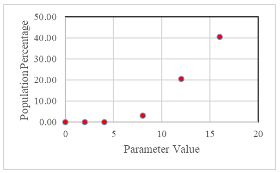
Scale parameters or departure time variations (σ) is one of the main attributes of agent decision-making time. The larger the σ, the larger the tail of the next departure time distribution. It is difficult to assign a specific value to the scale parameter to represent the actual state because, in real circumstances, many factors can affect it, such as community activities, both day and night, and the community's educational background. In this study, simulations were conducted to assess how refugees' departure times varied with the percentage of the population that evacuated. All residents were evacuated at the speed of adults. Then the scale parameters were varied by 0, 1, 2, 4, 8, and 16.
If the evacuation time refers to the actual situation, namely, from the appearance of hot cloud avalanches until an eruption occurs, the percentage of residents who have not evacuated to the evacuation post will be obtained. Residents evacuate immediately upon a hot cloud fall (t = 0). The population that did not evacuate occurred at σ = 8, accounting for 20.63%. Even when σ = 16, the percentage increases to 40.54%. If residents do not evacuate or evacuate late, it will cause injuries, economic losses, and even casualties.
This indicates that all residents must evacuate immediately, without delay. This variation may arise from individual differences in experience and in the perceived limits of danger and threat. Certain residents are reluctant to evacuate despite their neighbours having already evacuated. The eruption of Mt. Semeru in 2021 exemplifies this phenomenon. During signs of an eruption and subsequent evacuations, numerous residents remain unevacuated or fail to evacuate. Some residents continue to record the eruption and engage in sand mining activities during the event. This may indeed result in additional casualties. Research by Lee et al. [26] indicates a significant increase in the number of victims, corresponding to the rise in the distribution of departure times. Failure of residents to evacuate or delays in evacuation may result in injuries, economic losses, and potential fatalities.
4.1.4 Speed of people
Based on the previous explanation, in emergency situations, some people walk, making them vulnerable to danger and delays. In this simulation, we tested various speed scenarios and speed variations. Agents are given a constant running speed, and there is no effect of topography or influence of the speed of other agents. For the speed distribution using a normal distribution, the speed is set at 0.5 m/s, 1 m/s, and 1.5 m/s. As for the variation, it is 0.1 m/s, 0.2 m/s, and 0.4 m/s. The simulation was carried out on constant scale parameters (σ = 10) and waiting time (τ = 1 minute).
Based on Table 1, the longest scenario is when the variation is 0.4 m/s with a speed of 0.5 m/s. As many as 12.23% of the population have not evacuated within the specified time frame. Then, this was followed by a variation scenario of 0.2 m/s with a speed of 0.5 m/s, as many as 1.2% of the population have not evacuated within the simulation time range. Residents who have not evacuated were also found when the scenario varied to 0.4 m/s, with a speed of 1 m/s, at 0.56%. Residents with an average running speed of 0.5 m/s – 1 m/s have the potential to have delays in evacuation.
This highlights the need to consider the population's walking speed. During an emergency, many residents evacuate on foot. Walking poses challenges for vulnerable communities because of their compromised physical conditions, which result in delays and increased risk of injuries. The vulnerable groups identified are the elderly, children, individuals with disabilities, and pregnant women. Research indicates that the walking speed for children aged 5 to 9 years is 0.603 m/s [26]. The velocity for the elderly population, defined as individuals aged 65 years and above, is 0.783 m/s. According to the simulation results, both children and the elderly may experience delays when speeds remain below 1 m/s. The study area population is categorised by age groups: 7.49% are aged 5-9 years, and 8.24% are aged 65 years and older (BPS, 2022). This indicates that approximately 15.73% of the population is at risk of tardiness. Additionally, residents with disabilities and pregnant women are required to utilise vehicles for evacuation.
Wang et al. [17] demonstrated that the mortality rate was reduced by approximately 50% due to the enhanced utilisation of vehicles in tsunami evacuation scenarios. Moreover, walking speed significantly influences mortality rates. The mortality rate approaches 0% at walking speeds exceeding 2.5 m/s (indicative of running), but rises sharply to over 25% as speed decreases to 1 m/s (characteristic of slow walking). This underscores the necessity of addressing mobility issues in effective tsunami evacuation planning.
Table 1. Simulation results of evacuation speed
|
Speed Variation (m/s) |
Speed (m/s) |
Evacuation Time Based on Percentage of Evacuated Population (minutes) |
Percentage of Residents Who Were Not Successfully Evacuated |
||
|
When 50% of the population is evacuated |
When 90% of the population is evacuated |
When 99% of the population is evacuated |
|||
|
(1) |
(2) |
(3) |
(4) |
(5) |
(6) |
|
0.1 |
0.5 |
13.35 |
15.90 |
18.32 |
- |
|
1 |
13.37 |
15.92 |
18.37 |
- |
|
|
1.5 |
13.35 |
15.87 |
18.28 |
- |
|
|
0.2 |
0.5 |
13.33 |
16.02 |
- |
1.2 |
|
1 |
13.35 |
15.93 |
18.22 |
- |
|
|
1.5 |
13.35 |
15.92 |
18.37 |
- |
|
|
0.4 |
0.5 |
13.62 |
- |
- |
12.23 |
|
1 |
13.35 |
15.95 |
19.02 |
0.56 |
|
|
1.5 |
13.32 |
15.88 |
18.35 |
- |
|
This paper describes an evacuation study of the eruption of Mt. Semeru using an ABM approach. The project aims to determine how to develop a Semeru evacuation strategy using ABM, as well as the evacuation path, time variation, and speed under various conditions. This study concludes on various aspects based on the outcomes of the ABM simulation. First, the NetLogo application was used to successfully create an ABM simulation approach for the evacuation process following Mt. Semeru's eruption. Simulations are based on genuine circumstances. Second, the simulation results reveal the quickest path taken by refugees to the evacuation point, which may be utilised to create an evacuation route map. Third, the evacuation time and pace are dependent on the evacuation process. The evacuation time was nine minutes. The longer the waiting period and the bigger the variation, the later the emergency evacuation will occur. Fourth, speed and speed changes are important, with slower populations resulting in longer evacuations. In this regard, strategies that can be implemented include creating evacuation routes based on the quickest route, utilising proper EWS, enhancing community readiness, increasing officer capacity, and mapping area vulnerabilities.
It is recommended that time and speed be critical considerations in the evacuation process. An early warning system and community-based hazard management are required to allow early evacuation and self-evacuation behaviour, resulting in an effective and efficient evacuation process. The government is supposed to be able to spot emerging threats early, allowing citizens to escape. Some limitations to this study should be considered. This simulation does not account for the capacity of roadways and evacuation points. Furthermore, in practical scenarios, people respond to threats differently depending on their knowledge, educational level, physical condition, and disaster experience. As a result, these variables can be included in future research simulations.
[1] Ariyani, N., Fauzi, A. (2024). Measuring the resilience of rural tourism in Indonesia using the adjusted Mazziotta-Pareto index. Journal of Infrastructure, Policy and Development, 8(4): 3467. https://doi.org/10.24294/jipd.v8i4.3467
[2] Suhud, U., Allan, M., Hoo, W.C., Fitrianna, H., Noekent, V. (2024). Towards sustainable volcano tourism: Understanding visit intentions at Mount Anak Krakatau through destination credibility and environmental motivation. GeoJournal of Tourism and Geosites, 56(4): 1461-1473. https://doi.org/10.30892/gtg.56403-1317
[3] Filimonau, V., De Coteau, D. (2019). Tourism resilience in the context of integrated destination and disaster management (DM2). International Journal of Tourism Research, 22(2): 202-222. https://doi.org/10.1002/jtr.2329
[4] Rayawan, J., Tipnis, V.S., Pedraza-Martinez, A.J. (2021). On the connection between disaster mitigation and disaster preparedness: The case of Aceh province, Indonesia. Journal of Humanitarian Logistics and Supply Chain Management, 11(1): 135-154. https://doi.org/10.1108/jhlscm-12-2019-0081
[5] Pohan, R.A., Ramadhani, E., Marimbun, M., Chalidaziah, W., Nengsih, N., Marhaban, M. (2024). Disaster preparedness and safety curriculum for early childhood education in Indonesia. Prehospital and Disaster Medicine, 39(2): 228-229. https://doi.org/10.1017/s1049023x24000177
[6] Putri, L.K.R., Maryono, M. (2018). Assessing evacuation route against Mount Merapi hazard by using least cost path method in Mriyan-Boyolali, Indonesia. IOP Conference Series: Earth and Environmental Science, 123: 012008. https://doi.org/10.1088/1755-1315/123/1/012008
[7] Parvin, G.A., Sakamoto, M., Shaw, R., Nakagawa, H., Sadik, M.S. (2019). Evacuation scenarios of cyclone Aila in Bangladesh: Investigating the factors influencing evacuation decision and destination. Progress in Disaster Science, 2: 100032. https://doi.org/10.1016/j.pdisas.2019.100032
[8] Jumadi, Carver, S., Quincey, D. (2016). A conceptual framework of volcanic evacuation simulation of Merapi using agent-based model and GIS. Procedia - Social and Behavioral Sciences, 227: 402-409. https://doi.org/10.1016/j.sbspro.2016.06.092
[9] Sorensen, J.H. (2000). Hazard warning systems: Review of 20 years of progress. Natural Hazards Review, 1(2): 119-125. https://doi.org/10.1061/(asce)1527-6988(2000)1:2(119)
[10] Vogt, B.M., Sorensen, J.H. (1992). Evacuation research: A reassessment (No. ORNL/TM-11908). Oak Ridge National Lab., TN (United States).
[11] Malawani, M.N., Lavigne, F., Gomez, C., Mutaqin, B.W., Hadmoko, D.S. (2021). Review of local and global impacts of volcanic eruptions and disaster management practices: The Indonesian example. Geosciences, 11(3): 109. https://doi.org/10.3390/geosciences11030109
[12] Shoji, M., Takafuji, Y., Harada, T. (2020). Behavioral impact of disaster education: Evidence from a dance-based program in Indonesia. International Journal of Disaster Risk Reduction, 45: 101489. https://doi.org/10.1016/j.ijdrr.2020.101489
[13] Aulady, M.F.N., Fujimi, T. (2019). Earthquake loss estimation of residential buildings in Bantul regency, Indonesia. Jàmbá: Journal of Disaster Risk Studies, 11(1): a756. https://doi.org/10.4102/jamba.v11i1.756
[14] Pribadi, K.S., Abduh, M., Wirahadikusumah, R.D., et al. (2021). Learning from past earthquake disasters: The need for knowledge management system to enhance infrastructure resilience in Indonesia. International Journal of Disaster Risk Reduction, 64: 102424. https://doi.org/10.1016/j.ijdrr.2021.102424
[15] Ramdani, F., Setiani, P., Setiawati, D.A. (2019). Analysis of sequence earthquake of Lombok Island, Indonesia. Progress in Disaster Science, 4: 100046. https://doi.org/10.1016/j.pdisas.2019.100046
[16] Chu, H., Yu, J., Wen, J., Yi, M., Chen, Y. (2019). Emergency evacuation simulation and management optimization in urban residential communities. Sustainability, 11(3): 795. https://doi.org/10.3390/su11030795
[17] Wang, H., Mostafizi, A., Cramer, L.A., Cox, D., Park, H. (2016). An agent-based model of a multimodal near-field tsunami evacuation: Decision-making and life safety. Transportation Research Part C: Emerging Technologies, 64: 86-100. https://doi.org/10.1016/j.trc.2015.11.010
[18] Lim, H.R., Lim, M.B.B., Piantanakulchai, M. (2013). A review of recent studies on flood evacuation planning. Journal of the Eastern Asia Society for Transportation Studies, 10: 147-162. https://doi.org/10.11175/easts.10.147
[19] Liu, X., Lim, S. (2018). An agent-based evacuation model for the 2011 Brisbane City-scale riverine flood. Natural Hazards, 94(1): 53-70. https://doi.org/10.1007/s11069-018-3373-1
[20] Liu, X., Lim, S. (2016). Integration of spatial analysis and an agent-based model into evacuation management for shelter assignment and routing. Journal of Spatial Science, 61(2): 283-298. https://doi.org/10.1080/14498596.2016.1147393
[21] Wang, Z., Huang, J., Wang, H., Kang, J., Cao, W. (2020). Analysis of flood evacuation process in vulnerable community with mutual aid mechanism: An agent-based simulation framework. International Journal of Environmental Research and Public Health, 17(2): 560. https://doi.org/10.3390/ijerph17020560
[22] Bonabeau, E. (2002). Agent-based modeling: Methods and techniques for simulating human systems. Proceedings of the National Academy of Sciences of the United States of America, 99(suppl_3): 7280-7287. https://doi.org/10.1073/pnas.082080899
[23] Anshuka, A., van Ogtrop, F.F., Sanderson, D., Leao, S.Z. (2022). A systematic review of agent-based model for flood risk management and assessment using the ODD protocol. Natural Hazards, 112(3): 2739-2771. https://doi.org/10.1007/s11069-022-05286-y
[24] Chasanah, F., Sakakibara, H. (2022). Implication of mutual assistance evacuation model to reduce the volcanic risk for vulnerable society: Insight from Mount Merapi, Indonesia. Sustainability, 14(13): 8110. https://doi.org/10.3390/su14138110
[25] Zou, Q., Fernandes, D.S., Chen, S. (2019). Agent-based evacuation simulation from subway train and platform. Journal of Transportation Safety & Security, 13(3): 318-339. https://doi.org/10.1080/19439962.2019.1634661
[26] Lee, H.S., Sambuaga, R.D., Flores, C. (2022). Effects of tsunami shelters in Pandeglang, Banten, Indonesia, based on agent-based modelling: A case study of the 2018 Anak Krakatoa volcanic tsunami. Journal of Marine Science and Engineering, 10(8): 1055. https://doi.org/10.3390/jmse10081055
[27] Tan, L., Hu, M., Lin, H. (2015). Agent-based simulation of building evacuation: Combining human behavior with predictable spatial accessibility in a fire emergency. Information Sciences, 295: 53-66. https://doi.org/10.1016/j.ins.2014.09.029
[28] Sopha, B.M., Asih, A.M.S., Nurdiansyah, H.A., Maulida, R. (2018). Decision support system for an urban distribution center using agent‐based modeling: A case study of Yogyakarta Special Region Province, Indonesia. In City Logistics 2: Modeling and Planning Initiatives, pp. 179-196. https://doi.org/10.1002/9781119425526.ch11
[29] Cova, T.J., Johnson, J.P. (2003). A network flow model for lane-based evacuation routing. Transportation Research Part A: Policy and Practice, 37(7): 579-604. https://doi.org/10.1016/s0965-8564(03)00007-7
[30] AL Ghazo, A.T., Kumar, R. (2024). ANDVI: Automated network device and vulnerability identification in SCADA/ICS by passive monitoring. IEEE Transactions on Systems, Man, and Cybernetics: Systems, 54(4): 2539-2550. https://doi.org/10.1109/tsmc.2023.3345254
[31] Gozzoli, R.B., Gozzoli, P.C., Wattanacharoensil, W. (2024). Resilience model for a destination support: Pattaya, Thailand. Heliyon, 10(4): e26599. https://doi.org/10.1016/j.heliyon.2024.e26599
[32] Lee, D., Yoon, S., Park, E.S., Kim, Y., Yoon, D.K. (2018). Factors contributing to disaster evacuation: The case of South Korea. Sustainability, 10(10): 3818. https://doi.org/10.3390/su10103818
[33] Thompson, R.R., Garfin, D.R., Silver, R.C. (2016). Evacuation from natural disasters: A systematic review of the literature. Risk Analysis, 37(4): 812-839. https://doi.org/10.1111/risa.12654
[34] Liu, Y., Cheng, P., OuYang, Z. (2019). Disaster risk, risk management, and tourism competitiveness: A cross-nation analysis. International Journal of Tourism Research, 21(6): 855-867. https://doi.org/10.1002/jtr.2310
[35] Xu, Q., Zhu, G., Qu, Z., Ma, G. (2023). Earthquake and tourism destination resilience from the perspective of regional economic resilience. Sustainability, 15(10): 7766. https://doi.org/10.3390/su15107766
[36] Korolov, V., Kurowska, K., Korolova, O., Zaiets, Y., Milkovich, I., Kryszk, H. (2021). Methodology for determining the nearest destinations for the evacuation of people and equipment from a disaster area to a safe area. Remote Sensing, 13(11): 2170. https://doi.org/10.3390/rs13112170
[37] Lim, M.B.B., Lim, H.R., Anabo, J.M.L. (2021). Evacuation destination choice behavior of households in Eastern Samar, Philippines during the 2013 Typhoon Haiyan. International Journal of Disaster Risk Reduction, 56: 102137. https://doi.org/10.1016/j.ijdrr.2021.102137
[38] Wu, S., Lei, Y., Yang, S., Cui, P., Jin, W. (2022). An agent-based approach to integrate human dynamics into disaster risk management. Frontiers in Earth Science, 9: 818913. https://doi.org/10.3389/feart.2021.818913
[39] Maryanto, S., Setyowati, A.G., Aprilla, A.N., Sari, R.P.H., Ramadhani, N.H., Nurjannah, N. (2022). Implementation of town and school watching for disaster education to the communities in Sidomulyo village, Pronojiwo, Lumajang. International Journal of Disaster Management, 5(2): 141-158. https://doi.org/10.24815/ijdm.v5i2.29175
[40] Goto, Y., Ogawa, Y., Komura, T. (2010). Tsunami disaster reduction education using town watching and moving tsunami evacuation animation—Trial in Banda Aceh. Journal of Earthquake and Tsunami, 4(2): 115-126. https://doi.org/10.1142/s1793431110000728
[41] Eid, M.S., El-Adaway, I.H. (2017). Integrating the social vulnerability of host communities and the objective functions of associated stakeholders during disaster recovery processes using agent-based modeling. Journal of Computing in Civil Engineering, 31(5): 04017030. https://doi.org/10.1061/(asce)cp.1943-5487.0000680
[42] Khodabandelu, A., Park, J. (2021). Agent-based modeling and simulation in construction. Automation in Construction, 131: 103882. https://doi.org/10.1016/j.autcon.2021.103882