Mohammed F. Yass*![]() | Ahmed Al-Tikrite
| Ahmed Al-Tikrite![]()
© 2025 The authors. This article is published by IIETA and is licensed under the CC BY 4.0 license (http://creativecommons.org/licenses/by/4.0/).
OPEN ACCESS
The characteristics of riverbed material is of great importance to water resource professionals. These characteristics include size, shape, gradation, settling velocity, and specific gravity. Among these, size is one of the most important factors, as it plays a crucial role in calculating flow resistance as well as determining the quantity of transported sediments. The characteristics of the Tigris Riverbed materials were studied for the surface and sub-surface layers to understand and estimate future changes to the riverbed, such as erosion or sedimentation processes. A longitudinal section of the river was selected, extending over 82 km within Salah Al-Din governorate which is located in the north of Iraq. Eight cross-sections were chosen for sampling along the river. At each section, samples of the surface and subsurface bed materials were collected. The analysis results of these samples showed that the gravelly surface layer of the Tigris River has D50 value of 34 mm. It consists of 12.9% small cobbles, and 87.1% gravel. The sub-surface layer composed of gravel and sand with D50 value of 14 mm. It consists of 0.7% small cobbles, 87.5% gravel, and 11.8% sand. The above results of the Tigris River bed materials, consisting of both the surface and subsurface layers, indicate that gravel constitutes the majority. This suggests that the bed of the Tigris River can be classified as mainly gravelly.
river analysis, sediment discharge, water resources, gravel-bed rivers, Tigris River, surface layer, sub-surface layer
Since the earliest times and the beginning of creation, water has played a vital role in human life, as it is one of the most important factors for the sustainability of life on Earth [1, 2]. The massive population growth, along with the advancement of civilization worldwide, has led to an increased demand for water, making it necessary to optimally utilize all natural water resources and rivers are one of those resources [3]. These rivers have been vital water sources for most human civilizations that formed around and along their riverbanks, such as the Mesopotamian civilization in Iraq and the Nile Valley civilization in Egypt [4]. Therefore, it has become crucial to study these rivers with great care from all aspects, including hydraulics, hydrology, morphology, and geology. These rivers are considered important and complex natural systems that require continuous studies due to many factors that influence them [5]. These factors, in turn, affect the shape and nature of the river, which subsequently impacts various civil, agricultural, and industrial activities along its course. The mechanisms of sediment transport and the resulting changes in the river cross-section over the years due to erosion and deposition processes consequently lead to changes in the river's morphology, in addition to its impact on the stability of riverbanks [6-9]. Several efforts to address the water management related to sediment impact on river performance were studied [10, 11]. On the other hand, the variation in channel geometry impacted the water energy, and this impact on the side of channel could have a huge influence on the riverbank collapses [12]. This collapse in riverbanks would increase the sediment discharge and for sure will lead to a reduction in the water quality as well [13].
Therefore, specialists working within the field of river studies give great importance to examining the shape, size, and gradation of these materials due to their role in the processes of deposition and erosion along the river course [14, 15]. This helps to determine the shape and nature of the river and the hydraulics of flow by also affecting the value of flow resistance. Moreover, riverbed sediments have an impact on the quality of the flowing water and the nature of aquatic life present in the river, such as the types of fish and other aquatic organisms, as well as the types of aquatic plants that may grow on the riverbed and banks [16]. The size and distribution of riverbed sediments along the course of the river vary with distance and time due to the influence of various hydrological, hydraulic, and sedimentary variables. Consequently, researchers continuously study the nature of riverbed sediments to determine their different characteristics [6, 17, 18]. There have been many studies conducted on the characteristics of riverbed materials through the sieve analysis of riverbed sediments to determine sediment grain size, mean grain size, degree of sorting, skewness, and kurtosis parameters [19].
Billi and Paris [20] analyzed twenty-five samples taken from different locations along the gravel beds of two rivers in Italy. Their aim was to find a relationship between the characteristics of these materials. They also studied the effect of the river's hydraulic properties on the particle size distribution of the riverbed materials at each site. The results show no significant relationship between the grain size characteristics of different sediment units (bars, riffles, pools). while there was a strong correlation between the D84 and D16 grain sizes within the riffle sediments but D16 decreases about 2.5 times faster than D84 in riffle sediments. Kothyari [21] analyzed sixty-three samples of riverbed materials from different rivers at ten countries to identify the statistical relationships present in the gradation curve of these riverbed materials. The goal was to use these relationships to predict the particle size distribution of riverbed materials. The results found that the distribution of sediment does not follow a log normal distribution across all size ranges. Instead, power transformation was used to convert the size distribution into a shape that can follow a normal distribution. Nigussie Tekli [22] studied the nature and gradation of surface and subsurface bed materials at several stations along the course of the river (Kulfo) in southern Ethiopia. Their aim was to compare the moving bed sediment load with the riverbed materials. The results indicated that the medium-sized gravel and small stones are the main constituents of the surface for the riverbed. The average particles size of the diameter is varying from 40 to 57 mm. Also it was reported that the sub-surface consist were 60%, 23% and 14% of gravel, sand and stones, respectively. The NDICO company carried out an extensive study the characteristic of the river's bed consists at a specific area located between Baghdad and Mosul. The study reports that the D50 of the surface and subsurface layers are 40 mm and 8 mm, respectively at Mosul city [23]. On the other hand, Najib [24] studied the hydraulic, morphology and sediment characteristics for the Tigris River in Mosul city by take three cross-sections for 88 km from the river inside the city. The result show that the D50 of the surface and subsurface layers are 22 mm and 14 mm, respectively. In the same line, Moshib [25] studied the hydraulic, morphology and characteristics of sediments on 60 Km long section of Tigris River extending from Al-Fatha to Tikrit city. The study concluded that river's bed consists of surface layer (composed of gravel) and subsurface layers (composed of gravel and sand). The D50 of the surface layer is 33 mm while it is 11 mm for the subsurface layer. The particles shape of the surface layer is 50% disc-shaped, 19% spherical, 17% flat and 14% cylindrical. Another study was carried out on the Tigris River from the Mosul dam to the end of the Mosul city extending over a distance of 55 km. The characteristics of sediments were investigated to find the properties of the shape of surface and sub-surface layers. The results stated that the main surface layer particles were 48% disc-shaped, 25% spherical, 15% cylindrical and 11% flat-shaped particles. Also, the study concluded that 37 mm and 13 mm were the D50 of the surface and subsurface layer, respectively. The study reported that the coarse gravel is shielding the surface layer by 75% and the subsurface layer by 36% [26]. The sediment characteristics of the Tigris River in Kut City were also examined by collecting 146 samples, which were subsequently analyzed using sieve and hydrometer analysis techniques. Three classification systems for soil were adopted for this purpose: Blott and Pye, Folk, and the United States Department of Agriculture (USDA). The results indicated that the riverbed is composed of sand, clay, and silt, with varying proportions of 84.3%, 12.51% and 3.18%, respectively [27].
Studying the characteristics of riverbed materials is essential for understanding the river's morphology. Nama et al. [28] conducted a study on the morphology of the Tigris River in the area between Makhoul and Samarra, where part of the study involved analyzing both surface and subsurface layers of the riverbed soil. This was done by taking twenty soil samples from the riverbed, which were analyzed through sieve analysis in the laboratory to determine D16, D50, D84. The results showed that the sedimentary shapes were 49% disc particles, 21% blades, 16% spherical, and 13% cylindrical. The samples can be classified into Cobble Gravel, Pebble Gravel, Granule Gravel, and Sand. The study of sediment characteristics is also important when analyzing the stability of riverbanks, as demonstrated by Yass [29], who conducted a study on the stability of the Tigris Riverbanks within the study area. The results showed that the riverbed soil is gravelly and has reached a state of armoring.
The aim of this study is to investigate the sediment characteristics of the Tigris River within the study area, the nature of the riverbed soil such as the surface and sub-surface layer, and the changes that have occurred in the sediment gradation due to erosion and deposition processes. This study can also be used as a reference for other studies, including river morphology, riverbank stability, or sediment transport within the study area.
The Tigris River is one of the main rivers in Iraq and is among the most significant and ancient rivers in the world. It can be classified as a gravel-bed river at upstream due to the erosion processes that have affected it over the years [30-35].
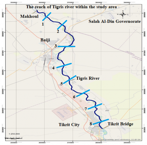
Figure 1. The reach within the study area
The study area extends from the city of Makhoul in the north to the city of Tikrit, covering a length of approximately 82 kilometers. This section of the Tigris River is considered important due to its location after the confluence of the Greater Zab and Lesser Zab rivers, which are the two main tributaries that contribute to 43-63% of the river's water [33]. Along this section of the river, many cities and villages are located within the Salah al-Din Governorate. There are also many irrigation projects that provide citizens with potable water for drinking and other uses, as well as for irrigating farms and fields in the villages. In this section of the Tigris River, which represents the study area, eight locations were selected along the river course for the purpose of collecting samples of riverbed materials, as shown in Figure 1. The following considerations were taken into account when selecting these sites: they represent different topographies of the river, accessibility between the two banks of the river, ease of sample collection without obstructions hindering the work, and avoiding areas that have been affected by human activities.
In this section of the Tigris River, which represents the study area, eight sections were selected along the river course for the purpose of collecting samples of the riverbed materials, as shown in Figure 1. Table 1 presents the coordinate of the collected samples. The following considerations were taken into account when selecting these sites: they represent different topographies of the river, accessibility between the two banks of the river, ease of sample collection without obstructions hindering the work, and avoiding areas that have been affected by human activities. The Tigris River in Salah al-Din Governorate is considered a gravel-bed river. In such rivers, the bed material consists of two layers: coarse surface layer made up of gravel, and a subsurface layer composed of gravel, sand, and fine materials. There are several methods for sampling for both the surface and subsurface layers of the riverbed soil, such as Volumetric, Grid, Areal and Transect Sampling. These methods have been explained in details by numerous researchers as shown in references [36-38]. In this study, the Transect Sampling method was adopted for sampling the surface layer by defining a distance across the width of the river from the bank, perpendicular to the flow. Two points on the riverbanks were identified by installing a metal rod on each bank in order to cross the river between them using a small boat. The samples were manually and randomly collected from the upper layer of the riverbed every 30 centimeters, with an average of 100 particles at each site then the collected samples were placed in a large metal container to be tested at the laboratory.
Table 1. The coordinate of collected samples
|
Cross - Section |
Location |
|
|
Latitude (N) |
Longitude E |
|
|
1 |
35.146075° |
43.438036° |
|
2 |
35.052026° |
43.554308° |
|
3 |
35.001071° |
43.569965° |
|
4 |
34.930831° |
43.515765° |
|
5 |
34.843825° |
43.561886° |
|
6 |
34.760404° |
43.633237° |
|
7 |
34.690564° |
43.671241° |
|
8 |
34.618663° |
43.682990° |
Three locations were selected in each section of the river sampling: the first one was in the upper third of the river, the second one was in the middle, and the third one was in the lower third. Then the Volumetric sampling method was adopted for sampling the subsurface layer by removing the surface layer material using a hand shovel to a depth equal to the diameter of the largest particle in that layer. Then, an excavation was made by a self-closing steel device, operating similarly to the Van Veen Grab, is used then manually inserted into the soil to ensure accurate sample collection without the loss of sediments. The samples were kept in robust plastic bags and stored in containers.
These methods are the most commonly used, widely recognized, and simplest methods compared to other available techniques.
The characteristics of sediments that form the riverbed material and are transported through the river are of great importance to water resources specialists. These properties include size, shape, gradation, settling velocity, and specific gravity. Among these, the most important property is size, as it is a key factor in calculating flow resistance and the quantity of transported sediments [6]. Sediment size can be expressed by diameter, settling velocity, weight, sieve aperture diameter, and can be measured using either external diameter gauges (calipers), optical methods, photographic methods, or by using sieve [39].
The median particle size D50 was obtained from the sediment size distribution and provides insight into the characteristics of sediment in the watercourse within the study area. It also gives an idea of the materials that are transported or deposited, as smaller particles remain suspended in the water, while larger and coarser materials settle at the riverbed. It is the most commonly used and widely recognized parameter for assessing the type of sediment that makes up the riverbed soil. Additionally, D50 was used to compare the results with other studies in the study area.
The variables that affect the characteristics of sedimentary channels are numerous and complex. Among these, the longitudinal slope of the river and the discharge passing through it are considered the main variables that determine the stream power, which in turn significantly influences the nature, shape, gradation, and distribution of riverbed materials. This is due to the crucial role of stream power in the process of erosion, transport, and deposition of bed materials and ultimately determining the characteristics and nature of the materials forming the riverbed. Therefore, it is essential to provide an overview of the gradient of the Tigris River, as well as information about the discharge values at the study area. This data will contribute to a better understanding of the dynamics influencing the riverbed materials in the region. The slope of the river within this area is about 3.8×10⁻⁴ according to previous studies [29], while the river discharges range within an average of 500 (m3/sec), The discharges may increase during the spring and rainy periods, reaching levels higher than the previously mentioned average.
5.1 The surface layer
Eight cross-sections were selected and identified within the study area, from each cross section about one hundred sediment samples were collected using the Transect Sampling method to collect the surface layer samples [36]. The samples were analyzed in the laboratory of the College of Engineering at Tikrit University to determine the gradation of the surface layer forming the riverbed.
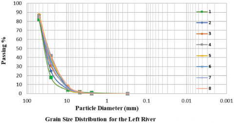
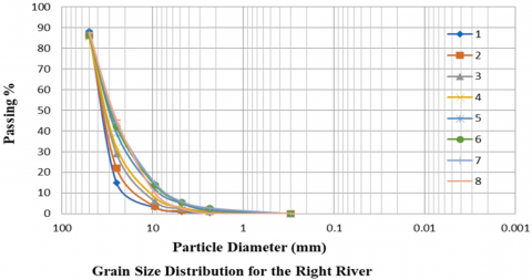
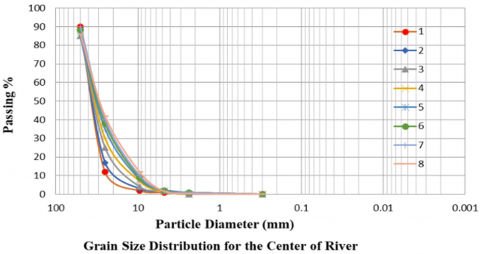
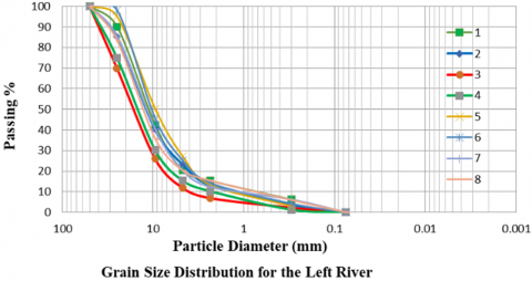
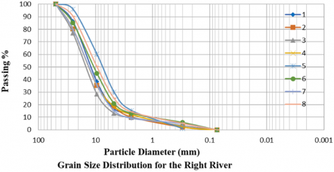
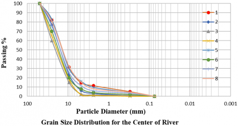
The grain size distribution for the samples of this layer was plotted along the study area, as shown in Figures 2-4. From these figures, it can be observed that it is mainly consisted of coarse gravel, with a minor of fine gravel and the average value of D50 was found to be 34 mm.
The Rouse classification was used to classify the surface bed materials [40]. Tables 2-4 present the sieve analysis of the surface layer samples using the sieves with the sizes indicated in the tables.
Figure 2. The grain size distribution for the lift side river
Figure 3. The grain size distribution for the right side rive
Figure 4. The grain size distribution for the center river
Table 2. Classification of surface bed materials for the left side from river
|
Left River |
|||||||||
|
Size (mm) |
Cross – Section |
Ave |
|||||||
|
1 |
2 |
3 |
4 |
5 |
6 |
7 |
8 |
||
|
130-64 |
12.94 |
12.68 |
10.55 |
12.41 |
11.58 |
12.47 |
10.39 |
11.42 |
11.8 |
|
64-32 |
44.06 |
43.77 |
41.4 |
40.21 |
39.93 |
42.65 |
40.77 |
41.76 |
41.8 |
|
32-16 |
38.69 |
39.12 |
39.77 |
38.51 |
38.88 |
35.43 |
37.63 |
38.25 |
38.3 |
|
16-8 |
3.37 |
3.11 |
7.07 |
8.08 |
8.72 |
8.54 |
10.1 |
7.61 |
7.1 |
|
8-4 |
0.94 |
1.32 |
1.21 |
0.79 |
0.89 |
0.91 |
1.11 |
0.96 |
1.0 |
|
4-2 |
0 |
0 |
0 |
0 |
0 |
0 |
0 |
0 |
0.0 |
Table 3. Classification of surface bed materials for the right side from river
|
Right River |
|||||||||
|
Size (mm) |
Cross – Section |
Ave |
|||||||
|
1 |
2 |
3 |
4 |
5 |
6 |
7 |
8 |
||
|
130-64 |
11.69 |
13.78 |
13.62 |
14.58 |
12.49 |
13.38 |
12.29 |
12.65 |
13.1 |
|
64-32 |
43.54 |
44.38 |
43.97 |
42.72 |
40.54 |
42.6 |
43.7 |
42.18 |
43.0 |
|
32-16 |
39.17 |
35.53 |
34.67 |
35.87 |
39.55 |
36.55 |
36.7 |
36.28 |
36.8 |
|
16-8 |
5.28 |
5.18 |
6.64 |
5.88 |
6.54 |
6.45 |
6.38 |
7.89 |
6.3 |
|
8-4 |
0.32 |
1.13 |
1.1 |
0.95 |
0.88 |
1.02 |
0.93 |
1 |
0.9 |
|
4-2 |
0 |
0 |
0 |
0 |
0 |
0 |
0 |
0 |
0.0 |
Table 4. Classification of surface bed materials for the center side from river
|
Center of River |
|||||||||
|
Size (mm) |
Cross – Section |
Ave |
|||||||
|
1 |
2 |
3 |
4 |
5 |
6 |
7 |
8 |
||
|
130-64 |
14.05 |
15.21 |
13.98 |
14.09 |
11.89 |
13.69 |
14.27 |
13.04 |
13.8 |
|
64-32 |
45.89 |
46.03 |
45.02 |
43.91 |
41.93 |
40.49 |
43.09 |
42.62 |
43.6 |
|
32-16 |
34.78 |
32.11 |
35.15 |
34.7 |
38.62 |
41.3 |
37.64 |
38.77 |
36.6 |
|
16-8 |
4.7 |
5.23 |
4.35 |
5.7 |
6.75 |
4.3 |
3.75 |
4.54 |
4.9 |
|
8-4 |
0.58 |
1.42 |
1.5 |
1.6 |
0.81 |
0.22 |
1.25 |
1.03 |
1.1 |
|
4-2 |
0 |
0 |
0 |
0 |
0 |
0 |
0 |
0 |
0.0 |
From Tables 2-4, the average composition of the surface layer of the riverbed can be derived for the whole reach within the study area as shown in Table 5.
Table 5. Classification of the average surface bed materials for the reach
|
Retained (%) |
|
|
Size (mm) |
Surface Layer |
|
The Average |
|
|
130-64 |
12.9 |
|
64-32 |
42.8 |
|
32-16 |
37.2 |
|
16-8 |
6.1 |
|
8-4 |
1.0 |
|
4-2 |
0 |
|
2-1 |
0 |
|
1-0.5 |
0 |
According to the Rouse classification of riverbed material, the surface layer can be classified based on sediment diameters, as shown in Table 6.
Table 6. Classification of surface bed materials according rouse classification
|
Classes |
Size (mm) |
Surface Layer (%) |
|
Small Cobble |
130-64 |
12.9 |
|
Very Coarse Gravel |
64-32 |
42.8 |
|
Coarse Gravel |
32-16 |
37.2 |
|
Medium Gravel |
16-8 |
6.1 |
|
Fine Gravel |
8-4 |
1 |
|
Very Fine Gravel |
4-2 |
0 |
|
Very Coarse Sand |
2-1 |
0 |
|
Cores Sand |
1-0.5 |
0 |
From Table 6, it is evident that gravel constitutes about 100% of the surface layer materials. The dominant class of the surface bed materials is the very coarse gravel by 42.8%, coarse gravel, which makes up 37.2%. The fine gravel and sand content is negligible in this layer, which classifies the Tigris River in this area as gravel-bed. To assess the changes in the sediment characteristics of the riverbed over years, the results of this study were compared with previous studies. Moshib [25] found that the D50 of Tigris River, extending from the Al-Fatha area to Tikrit, was 33 mm. In our current study, the D50 of the surface layer was 34 mm. From these comparisons, it can be concluded that there have been no significant changes in the riverbed material properties of Tigris River, except for the erosion of some movable gravel particles from the surface layer. Given the current discharge of 500 m³/s, as long as the river flow remains within its current boundaries, these sediment properties will likely remain stable in the future.
5.2 The sub-surface layer
Eight samples were collected from the left side of the river, eight from the center, and eight from the right side, which means that three samples were collected at each cross-section. The Volumetric Method was used to collect the sub-surface layer samples [36]. The samples were analyzed in the laboratory of the College of Engineering at Tikrit University to determine the gradation of the sub-surface layer forming the riverbed.
Figure 5. The grain size distribution for the lift side river
Figure 6. The grain size distribution for the right side river
Figure 7. The grain size distribution for the center of river
The grain size distribution for the samples of this layer was plotted along the study area, as shown in Figures 5-7. From these figures it can be observed that it was mainly consisted of gravel, with a minor of sand and the average value of D50 was found to be 14 mm.
The Rouse classification was used to classify the sub-surface bed materials. Tables 7-9 present the sieve analysis of the sub-surface layer samples using the sieves with the sizes indicated in the tables.
Table 7. Classification of sub-surface bed materials for the left side from river
|
Left River |
|||||||||
|
Size (mm) |
Cross – Section |
Ave |
|||||||
|
1 |
2 |
3 |
4 |
5 |
6 |
7 |
8 |
||
|
130-64 |
0.84 |
0.68 |
0.55 |
0.43 |
0.58 |
0.47 |
0.39 |
0.42 |
0.5 |
|
64-32 |
5.16 |
6.17 |
4.8 |
3.8 |
6.13 |
4.25 |
5.85 |
5.76 |
5.2 |
|
32-16 |
25.1 |
25.62 |
31.77 |
32.77 |
25.5 |
22.51 |
24.63 |
26.91 |
26.9 |
|
16-8 |
41.65 |
33.96 |
39.51 |
35.48 |
35.56 |
40.08 |
39.89 |
39.03 |
38.1 |
|
8-4 |
10.54 |
10.82 |
8.11 |
8.73 |
9.19 |
8.53 |
9.91 |
7.96 |
9.2 |
|
4-2 |
5 |
7 |
4.09 |
5.12 |
8.87 |
8.98 |
8 |
4.96 |
6.5 |
|
2-1 |
6.06 |
9.5 |
6.21 |
9.01 |
6.35 |
9.02 |
6.12 |
8.38 |
7.6 |
|
1-0.5 |
5.65 |
6.25 |
4.96 |
4.66 |
7.82 |
6.16 |
5.21 |
6.58 |
5.9 |
Table 8. Classification of sub-surface bed materials for the right side from river
|
Right River |
|||||||||
|
Size (mm) |
Cross – Section |
Ave |
|||||||
|
1 |
2 |
3 |
4 |
5 |
6 |
7 |
8 |
||
|
130-64 |
0.69 |
0.78 |
0.62 |
0.58 |
0.49 |
0.38 |
0.29 |
0.45 |
0.5 |
|
64-32 |
4.54 |
1.42 |
3.77 |
2.78 |
3.54 |
4.32 |
4.7 |
4.78 |
3.7 |
|
32-16 |
24.17 |
25.53 |
31.01 |
25.57 |
27.45 |
27.55 |
29.99 |
23.28 |
26.8 |
|
16-8 |
42.93 |
40.88 |
38.17 |
40.18 |
35.32 |
39.25 |
40.11 |
38.79 |
39.5 |
|
8-4 |
11.09 |
10.25 |
10.1 |
9.11 |
7.48 |
6.25 |
8.16 |
8.15 |
8.8 |
|
4-2 |
3.02 |
8.13 |
3.36 |
7.13 |
10.27 |
7.55 |
6.1 |
11.12 |
7.1 |
|
2-1 |
8.33 |
8.03 |
6.5 |
7.87 |
8.33 |
6.3 |
4.28 |
6.03 |
7.0 |
|
1-0.5 |
5.23 |
4.98 |
6.47 |
6.78 |
7.12 |
8.4 |
6.37 |
7.4 |
6.6 |
Table 9. Classification of sub-surface bed materials for the center of river
|
Center of River |
|||||||||
|
Size (mm) |
Cross – Section |
Ave |
|||||||
|
1 |
2 |
3 |
4 |
5 |
6 |
7 |
8 |
||
|
130-64 |
1.05 |
1.21 |
0.98 |
1.09 |
0.89 |
0.79 |
0.97 |
1.04 |
1.0 |
|
64-32 |
8.29 |
8.03 |
5.02 |
7.91 |
7.31 |
8.69 |
7.29 |
8.62 |
7.6 |
|
32-16 |
22.8 |
27.25 |
43.15 |
44.66 |
22.32 |
38.7 |
27.64 |
24.77 |
31.4 |
|
16-8 |
46.2 |
45.65 |
40.05 |
30.2 |
42.56 |
30.85 |
41.06 |
40.53 |
39.6 |
|
8-4 |
9.58 |
8.82 |
3.55 |
7.6 |
10.81 |
4.22 |
9.25 |
8.03 |
7.7 |
|
4-2 |
4.2 |
3.05 |
0.75 |
0.7 |
6.31 |
8.5 |
3.5 |
5.49 |
4.1 |
|
2-1 |
3.38 |
2.21 |
0.6 |
0.8 |
3.68 |
0.8 |
3.59 |
4.17 |
2.4 |
|
1-0.5 |
4.5 |
3.78 |
5.9 |
7.04 |
6.12 |
7.45 |
6.7 |
7.35 |
6.1 |
Table 10. Classification of the average sub-surface bed materials for the reach
|
Retained (%) |
|
|
Size (mm) |
Sub-Surface Layer |
|
Average |
|
|
130-64 |
0.7 |
|
64-32 |
5.5 |
|
32-16 |
28.4 |
|
16-8 |
39.1 |
|
8-4 |
8.6 |
|
4-2 |
5.9 |
|
2-1 |
5.6 |
|
1-0.5 |
6.2 |
From Tables 7-9, the average composition of the sub-surface layer of the riverbed can be derived for the whole reach within the study area as shown in the Table 10.
According to the Rouse classification of riverbed material, the sub-surface layer can be classified based on sediment diameters, as shown in Table 11.
Table 11. Classification of sub-surface bed materials according rouse classification
|
Classes |
Size (mm) |
Sub-Surface Layer (%) |
|
Small Cobble |
130-64 |
0.7 |
|
Very Coarse Gravel |
64-32 |
5.5 |
|
Coarse Gravel |
32-16 |
28.4 |
|
Medium Gravel |
16-8 |
39.1 |
|
Fine Gravel |
8-4 |
8.6 |
|
Very Fine Gravel |
4-2 |
5.9 |
|
Very Coarse Sand |
2-1 |
5.6 |
|
Cores Sand |
1-0.5 |
6.2 |
From Table 11, it is evident that gravel constitutes about 100% of the sub-surface layer materials. The dominant class of the sub-surface bed materials is the coarse gravel by 28.4%, followed by Medium coarse gravel by 39.1% and the percentage of sand in this layer was about 11.8%. To assess the changes in the sediment characteristics of the subsurface layer of the Tigris River over years, the results of this study were compared with previous studies. Moshib [25] found that the D50 of the Tigris River, extending from the Al-Fatha area to Tikrit, was 11 mm. In our current study, the D50 of the subsurface layer was 14 mm. From these comparisons, it can be concluded that changes have occurred in the riverbed material properties of the Tigris River, leading to the erosion of some particles from the sub-surface layer.
It can be observed from the gradation of the soil layers of the riverbed that the surface layer is devoid of fine gravel and sand due to its direct contact with water, which has caused the erosion of these particles, leaving behind the larger particles that are difficult to transport under the current conditions of Tigris River. On the other hand, the sub-surface layer contains fine gravel and sand in varying gradations and proportions, in small amounts, due to its position under the surface layer, which provides some degree of protection for it.
The results of this study, as well as other studies focusing on sediment characteristics, are of great significance in determining the nature of riverbed sediments from the grain size distribution also understanding the mechanisms and processes involved in their transport. Consequently, provide important and valuable insights that support and enhance sustainable development strategies. In addition, these results assist those interested in the field of water resources and decision-makers in the effective management and handling of river water systems.
This study has certain limitations that should be acknowledged and taken into consideration when applying the methodology to other areas. These include the difficulty of collecting sediment samples from the riverbed, particularly subsurface soil samples and the challenge of preserving them during extraction to prevent leakage or loss into the water, which may affect the accuracy of the results.
Based on the results obtained from this study, the following conclusions can be derived:
1. The bed of Tigris River consists of two layers: surface gravel layer with a D50 value of 34 mm, and a subsurface layer composed of gravel and sand with a D50 value of 14 mm.
2. The surface layer of the riverbed consists of 12.9% small cobbles and 87.1% gravel. The gravel is further divided into 42.8% very coarse gravel, 37.2% coarse gravel, 6.1% medium gravel, and 1% fine gravel. Regarding the sand, it is non-existed in this layer.
3. The sub-surface layer of the riverbed consists of 0.7% small cobbles, 87.5% gravel, and 11.8% sand. The gravel is further divided into very coarse gravel by 5.5%, coarse gravel by 28.4%, medium gravel by 39.1%, fine gravel by 8.6% and very fine gravel by 5.9%. The sand is further divided into very coarse sand by 5.6% and coarse sand by 6.2%.
4. The above percentages of the Tigris River bed materials, consisting of both the surface and subsurface layers, indicate that gravel constitutes the majority. This suggests that the bed of the Tigris River can be classified as mainly gravelly.
5. The percentage of sand and very fine gravel is almost non-existed in the surface layer materials. These materials, which forms about 26.3% of the subsurface layer, can be considered part of the river's original bed materials. Over the years, they have eroded, and their proportion in the surface layer has decreased to no more than 1%.
6. Through the analysis the sediment of riverbed and comparison with previous studies, it has been determined that the riverbed has reached a state of armoring and this is consistent with the findings of Yass [29].
7. The importance of the current study resides in its ability to serve as a reference to investigate river's morphology and stability of river bank. Utilizing this research study might help in developing significant strategies for water management and conservation.
8. The hydraulic and morphological factors significantly affected by sediment properties of the surface and sub-surface layers of the riverbed. For instance, the ability of water to carry materials get reduced when surface layer composes of coarse gravel. In addition, the sub-surface layer protected by the surface layer, contributes to the stability of the riverbed and reduces erosion, which affects the morphological formation of the river.
9. The methodology adopted in this study for determining sediment characteristics is a well-established approach that has been applied in many rivers around the world. Moreover, its results are reliable for identifying sediment types and can be replicated in other sections of the Tigris River. More advanced methodologies and techniques can also be use, such as End-Member Modeling Analysis, CM image, Multivariate statistical analysis and Principal Component Analysis (PCA). These methods will provide a deeper understanding of the analysis and distribution of riverbed sediments.
It is worth mentioning that modelling and measuring a coarse gravel riverbed consider a complicated process and might results in different outcomes. As such, it is significant to investigate the surface layer using digital imaging methods and others software analysis. Then, the analytical outcomes must be verified with the experimental results obtained from the literature. In addition, for more accuracy, it necessary to consider more cross-sections in the investigated area to obtain more data and to reduce the margin of error as low as possible.
The authors are grateful for the support provided by the Department of Civil Engineering, College of Engineering, Tikrit University for this work in shape of providing the necessary equipment inside the laboratory to conduct all the experiments.
[1] Roberson, J.A., Cassidy, J.J., Chaudhry, M.H. (1998). Hydraulic Engineering. John Wiley & Sons.
[2] Wang, Y., He, Y., Zhan, J., Li, Z. (2022). Identification of soil particle size distribution in different sedimentary environments at river basin scale by fractal dimension. Scientific Reports, 12(1): 10960. https://doi.org/10.1038/s41598-022-15141-6
[3] Clarke, R. (2013). Water: The International Crisis. Routledge, London. https://doi.org/10.4324/9781315070261
[4] Hosseiny, S.H., Bozorg-Haddad, O., Bocchiola, D. (2021). Water, culture, civilization, and history. In Economical, Political, and Social Issues in Water Resources, pp. 189-216. https://doi.org/10.1016/B978-0-323-90567-1.00010-3
[5] Schumm, S.A. (2007). River Variability and Complexity. Cambridge University Press.
[6] Garde, R.J., Raju, K.R. (2000). Mechanics of Sediment Transportation and Alluvial Stream Problems. Taylor & Francis.
[7] Yass, M.F., Khalaf, R.M. (2025). Assessment of the Riverbank Stability for Tigris River in Salahaddin Governorate/Iraq using BSTEM Model. Tikrit Journal of Engineering Sciences, 32(2): 1-18. https://doi.org/10.25130/tjes.32.2.13
[8] Mohammed-Ali, W., Mendoza, C., Holmes Jr, R.R. (2020). Influence of hydropower outflow characteristics on riverbank stability: Case of the lower Osage River (Missouri, USA). Hydrological Sciences Journal, 65(10): 1784-1793. https://doi.org/10.1080/02626667.2020.1772974
[9] Mohammed-Ali, W., Mendoza, C., Holmes, R.R. (2021). Riverbank stability assessment during hydro-peak flow events: The lower Osage River case (Missouri, USA). International Journal of River Basin Management, 19(3): 335-343. https://doi.org/10.1080/15715124.2020.1738446
[10] Yass, M.F., Khalaf, R.M. (2025). The applicability of riverbank stability models. Mathematical Modelling of Engineering Problems, 12(2): 577-588. https://doi.org/10.18280/mmep.120221
[11] Mahmood, K.M., Mohammed-Ali, W.S. (2025). A hydraulic performance model of Khassa Chai River under varying flow conditions. Engineering, Technology & Applied Science Research, 15(2): 20934-20940. https://doi.org/10.48084/etasr.9675
[12] Torabi, M., Hamedi, A., Alamatian, E., Zahabi, H. (2019). The effect of geometry parameters and flow characteristics on erosion and sedimentation in channels junction using finite volume method. arXiv preprint, arXiv:1906.10102. https://doi.org/10.48550/arXiv.1906.10102
[13] Al-Fahal, A.S., Ahmed, A.S., Mohammed, A.K., Mohammed-Ali, W.S. (2024). Evaluation of rainwater harvesting systems for drinking water quality in Iraq. International Journal of Design & Nature and Ecodynamics, 19(1): 111-117. https://doi.org/10.18280/ijdne.190113
[14] Hack, J.T. (1957). Studies of longitudinal stream profiles in Virginia and Maryland (Vol. 294). US Government Printing Office.
[15] Richards, K. (2024). Rivers: Form and Process in Alluvial Channels. Routledge.
[16] Bilotta, G.S., Brazier, R.E. (2008). Understanding the influence of suspended solids on water quality and aquatic biota. Water Research, 42(12): 2849-2861. https://doi.org/10.1016/j.watres.2008.03.018
[17] Jassim, F.N., Abbaas, S.A. (2024). Review of sediment transport and rating curve in the Tigris River, Iraq. In the 2nd International Conference of Engineering Science (CESC).
[18] López, G.I. (2016). Grain size analysis. In Gilbert, A.S. (eds) Encyclopedia of Geoarchaeology. Encyclopedia of Earth Sciences Series. Springer, Dordrecht, pp. 341-348. https://doi.org/10.1007/978-1-4020-4409-0_18
[19] Kim, S., Ahn, J., Kim, H., Kwon, H., Kim, G., Shin, D., Yang, D. (2018). The distribution characteristics of grain size and organic matters of surface sediments from the Nakdong-Goryeong mid-watershed. Journal of Environmental Science International, 27(6): 411-423. https://doi.org/10.5322/JESI.2018.27.6.411
[20] Billi, P., Paris, E. (1992). Bed sediment characterization in river engineering problems. Erosion and Sediment Transport Monitoring Programmes in River Basins, 210: 11-20.
[21] Kothyari, U.C. (1995). Frequency distribution of river bed materials. Sedimentology, 42(2): 283-289. https://doi.org/10.1111/j.1365-3091.1995.tb02103.x
[22] Nigussie Tekli, H.B.H. (2007). Bed load transport in armoured gravel-bed river: Case study of Kulfo River. Southern Ethiopia FWU Water Resources, Catchment and Lake Research LARS.
[23] Othman, K., Bilal, A.A., Sulaman, Y.I. (2012). Morphologic characteristics of Tigris River with at Mosul City. Tikrit Journal of Engineering Sciences, 19(3): 36-54. https://doi.org/10.25130/tjes.19.3.12
[24] Najib, Y.E. (1980) Characteristics of Tigris River at Mosul. MSc Thesis, College of Engineering, University of Mosul, Iraq. https://www.scirp.org/reference/referencespapers?referenceid=1153369.
[25] Moshib, A.K. (1986). Characteristics study of Tigris River from Fatha to Tikrit City (Doctoral dissertation, M. Sc. Thesis, Water resources Dep., College of engineering, Mosul University, Mosul, Iraq).
[26] Nama, A.H., Maatooq, J.S., Abbas, A.S. (2022). Review and state of the art for the hydro-morphological modeling of transboundary rivers, Tigris River as a case study. Arabian Journal of Geosciences, 15: 1043. https://doi.org/10.1007/s12517-022-10248-6
[27] Jassim, F.N., Abbas, S.A. (2024). Analysis of statistical parameters of sediment grain size distribution for Tigris River downstream Kut Barrage, Iraq. Mathematical Modelling of Engineering Problems, 11(12): 3489-3498. https://doi.org/10.18280/mmep.111227
[28] Nama, A.H., Abbas, A.S., Maatooq, J.S. (2022). Field and satellite images-based investigation of rivers morphological aspects. Civil Engineering Journal, 8(7): 1339-1357. http://doi.org/10.28991/CEJ-2022-08-07-03
[29] Yass, M.F. (2024). Hydrodynamic-morphological investigation for the riverbank stability of Tigris River within salah Al-Din governorate, Doctoral dissertation, Tikrit University.
[30] Al-Taiee, T.M. (2005). Response capability of Tigris River bed to armoring phenomenon after Mosul dam operation. Rafidain Journal of Science, 16(3): 96-108. https://doi.org/10.33899/rjs.2005.41357
[31] Othman, K.I., Deguan, W. (2004). Characteristics of Tigris River bed at Mosul city, Iraq. Journal of Lake Sciences, 16(Z1): 61-70.
[32] Kirikche, E.M. (1985). Sediment characteristics of Tigris River between Zakho and Fatha. University of Mosul.
[33] Abbas, N., Wasimi, S.A., Al-Ansari, N. (2017). Impacts of climate change on water resources of Greater Zab and Lesser Zab Basins, Iraq, using soil and water assessment tool model. International Journal of Environmental, Chemical, Ecological, Geological and Geophysical Engineering, 11(10): 823-829. https://www.researchgate.net/publication/320020983_Impacts_of_Climate_Change_on_Water_Resources_of_Greater_Zab_and_Lesser_Zab_Basins_Iraq_Using_Soil_and_Water_Assessment_Tool_Model/stats.
[34] Al-Ansari, N.A., Toma, A. (1984). Bed characteristics of the River Tigris within Baghdad. Journal of Water Research, 3(1): 1-23. https://www.researchgate.net/publication/282337042_Bed_characteristics_of_the_River_Tigris_within_Baghdad.
[35] Othman, K.I., Hameed, A.T. (2014). Properties of Tigris River bed material at Mosul city. Tikrit Journal of Engineering Sciences, 21(1): 30-44. https://doi.org/10.25130/tjes.21.1.09
[36] Kellerhals, R., Bray, D.I. (1971). Sampling procedures for coarse fluvial sediments. Journal of the Hydraulics Division, 97(8): 1165-1180. https://doi.org/10.1061/JYCEAJ.0003044
[37] Kellerhals, R., Church, M., Bray, D.I. (1976). Classification and analysis of river processes. Journal of the Hydraulics Division, 102(7): 813-829. https://doi.org/10.1061/JYCEAJ.0004583
[38] Khaleel, M.S. (1986). Analysis of surface layer material of Tigris River at Mosul City. Irrigation and Drainage Department, University of Mosul, Iraq, College of Engineering.
[39] Simons, D.B., Şentürk, F. (1992). Sediment Transport Technology: Water and Sediment Dynamics. Water Resources Publication.
[40] Simons, D.B. (1981). Design guidelines and criteria for channels and hydraulic structures on sandy soils. Aurora, Colorado. https://www.amazon.com/guidelines-criteria-channels-hydraulic-structures/dp/B0006XZ2UY.