Marlaini![]() | Idris
| Idris![]() | Zikri Alhadi*
| Zikri Alhadi*![]()
© 2025 The authors. This article is published by IIETA and is licensed under the CC BY 4.0 license (http://creativecommons.org/licenses/by/4.0/).
OPEN ACCESS
Mitigation constitutes a comprehensive endeavor to eliminate or diminish the risks associated with disaster hazards that impact vulnerable populations. The prevention and management of land fire disasters ought to be conducted by governmental agencies in alignment with their designated responsibilities and functions; however, these initiatives have not been executed satisfactorily or optimally and have demonstrated ineffectiveness in both the prevention and management of disaster mitigation strategies, particularly concerning land fire disasters. In light of this, this study aims to reconstruct the progression of land fire disaster mitigation policies utilizing the disaster management continuum model within the context of Solok Regency, Indonesia. The disaster management continuum model is extensively acknowledged as the most efficacious framework due to its representation of various stages, aiding implementation. The methodology employed in this research is qualitative, as it is anticipated to facilitate a reconstruction of land fire disaster mitigation policies through the lens of the disaster management continuum approach. The scope of this study is confined to the aspects of land fire disaster mitigation policies that emphasize participatory engagement. The research findings reveal that the practical application of the disaster mitigation model utilizing the disaster management continuum method is substantiated by comprehensive and effective implementation. The reconstruction of the land fire disaster mitigation model can serve as an educational instrument for the community regarding land fires, thereby potentially mitigating the risk of substantial losses. This is essential to thoroughly comprehend local conditions, geological characteristics, climatic factors, and distinctive socio-economic variables in specific regions.
policy reconstruction, mitigation, community participation, disasters, land fires
Indonesia presents an array of disaster potentials attributable to both natural and anthropogenic factors. The National Disaster Management Agency reported that from 2020 to 2021, there were 979 occurrences of fire-related disasters within residential zones. The occurrence of fire disasters is inherently unpredictable. Furthermore, the ignition of such fires may be instigated by natural phenomena, including extreme solar radiation, lightning strikes, volcanic activity, seismic events, and cyclonic storms [1-6]. According to data provided by the Forestry Service in 2021, West Sumatra Province encompasses a forested area of approximately 2,286,883.10 hectares. Additionally, the Decree issued by the Director General of Watershed Management and Social Forestry, numbered SK.4 / V-DAS / 2015, which pertains to the Establishment of National Forest and Critical Land Maps and Data as of 2015, indicates that the cumulative extent of critical land within West Sumatra Province is 630,695 hectares. The essential expanse of land, measuring 630,695 hectares in West Sumatra Province, has garnered significant attention from governmental authorities, specifically placing the responsibility upon the West Sumatra Provincial Forestry Service to mitigate this statistic by curtailing the rate of deforestation. Deforestation rates are reduced through many strategies, including diminishing the extent of critical land, decreasing hotspots, and securing and safeguarding designated areas. Exploiting natural resources beyond the threshold of environmental carrying capacity, in conjunction with a lack of initiatives aimed at conserving soil and water resources, has culminated in environmental imbalances, particularly manifested through the persistent expansion of critical land [7-11]. Critical land constitutes a designation for a region that has undergone degradation, resulting in the incapacity of the land to perform its intended ecological functions [12-14].
The essential acceleration of land proliferation is further exacerbated by intensified population pressures on land, particularly within the island of Java. Consequently, the continuous exploitation of land leads to diminished land productivity and nutrient depletion [15-19]. This situation ultimately precipitates a decline in agricultural yields, heightened erosion, increased sedimentation, flooding, drought, river shallowing, reduced reservoir longevity, and various other environmental challenges. Despite implementing land rehabilitation and soil and water conservation initiatives through greening and reforestation projects, these measures have proven insufficient in addressing the burgeoning area of critical land. This inadequacy is primarily attributed to the predominant focus on physical interventions, which inadequately address the socio-economic and cultural issues faced by the community. Therefore, to effectively curtail the escalation of critical land, it is imperative to adopt a comprehensive, integrative, and multisectoral approach [20-27] while actively engaging the full participation of the community. Numerous individuals resort to land clearing via burning at the peripheries of industrial forest plantation regions, coupled with limited capabilities for effective fire management.
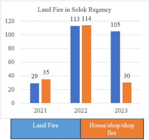
Based on data obtained from the local government, many fire incidents still occur in West Sumatra. In 2023 there were 28 cases, the most in Solok Regency and Padang City. Based on data from the initial evaluation analysis, information was obtained that fire incidents specifically in Solok Regency, from 2021, showed a significant increase in 2022. The data can be seen in the following table:
Table 1. Data on fire incidents in Solok Regency from 2021 to 2023
|
No. |
Types of Fire |
Years |
||
|
2021 |
2022 |
2023 |
||
|
1 |
Land fires |
29 |
113 |
105 |
|
2 |
House/shop/shop fires |
35 |
114 |
30 |
|
Total events |
64 |
227 |
135 |
|
Table 1 describes that the incidence of fires in Solok Regency from 2021 to 2023 has increased quite significantly, this can be seen from the data on land fires in 2021 as many as 29 incidents, rising in 2023 as many as 35 incidents, if seen from the incidence of land fires there was also an increase but not so significant this can be seen from the cases of land fires as many as 113 cases in 2021 and incidents in 2022 as many as 114 cases. In 2023, there were 37 cases of fires in Solok Regency from 2021 to 2023. More complete information can be seen in Figure 1.
Figure 1. Fire incident data
The data shows that land fires and house/shop/shop fires are more common in house/shop/shop fires, but the difference is not that much. Land fire incidents are also included in the high category in Solok Regency. The results of interviews with the Solok Regency Regional Disaster Management Agency support the data above. The occurrence of fires in Solok Regency from 2021 to 2022 has increased significantly, but in 2023, there was a decrease, although it has not had much impact.
This can be seen from West Sumatra, Solok Regency, where fires are still high. Although the Government has carried out disaster management efforts through related departments/agencies/agencies as well as non-governmental institutions/organizations and the community, disaster incidents continue to show an increase in both intensity and impact of losses [28-36]. For this reason, disaster reduction efforts must continue to be carried out and constantly improved. One of these efforts is to provide practical knowledge about disaster characteristics and mitigation efforts to all stakeholders [37-40]. Disasters are one of the most serious problems faced by all countries worldwide. A remarkable global trend towards increasing deaths, casualties, and economic losses due to disasters has been seen in recent years [41].
To avert or mitigate the future ramifications of fire-related disasters, it is imperative to devise a comprehensive fire disaster mitigation and preparedness program. Mitigation constitutes an endeavor to eradicate or attenuate the risk posed by disaster hazards to at-risk populations [42-46]. The parameters of mitigation encompass the elimination and reduction of risks and the delegation of responsibility, thereby facilitating a concentrated effort on eradicating or limiting the likelihood of disaster occurrences [36, 47-49]. Preparedness for imminent disasters represents a strategic initiative to enhance the community's capacity to respond proficiently to the threats and repercussions of catastrophe while ensuring a swift recovery from prolonged impacts [50-52]. The active engagement of the community is paramount in the realm of disaster preparedness [53, 54].
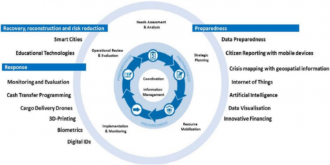
Governmental entities should execute the prevention and management of forest and land fire disasters by their designated responsibilities and functions; however, such efforts have not been adequately or optimally realized, rendering them less effective in prevention, management, or disaster mitigation. Moreover, enforcing legal measures is a critical action that the government must undertake to instill a deterrent effect on individuals who persist in land burning during arid seasons. This is particularly salient given that one of the predominant factors contributing to forest and land fires is anthropogenic, specifically among communities that continue to use land burning annually for agricultural and horticultural purposes [55]. The European Parliamentary Research Service elucidates that the classification of technological advancements facilitating the Humanitarian Program Cycle (HPC) is intricately associated with four principal disaster management activities, namely preparedness, response, recovery, reconstruction, and disaster risk reduction (see Figure 2):
Figure 2. Disaster management activities
In the reconstruction of disaster mitigation policies, executing the disaster management framework is contingent upon the particular circumstances and disaster susceptibilities within a designated region. This investigation emerges from the inadequacies of mitigation policies that excessively rely on governmental organizations' minimal capacities and capabilities, particularly concerning the requisite resources. Consequently, an alternative approach is necessitated within policy discourse, specifically regarding enhancing community engagement in disaster management, constituting a critical component of policy reconstruction. In this examination, the researcher has opted to employ the disaster management continuum model as a foundational framework for reformulating land fire disaster mitigation policy in Solok Regency. The disaster management continuum model is esteemed as a preeminent framework due to its representation of distinct phases, facilitating implementation. The phases of disaster management encapsulated within this model comprise emergency response, relief efforts, rehabilitation, reconstruction, mitigation strategies, preparedness initiatives, and early warning systems, all of which are essential components of efficacious disaster mitigation management, particularly in augmenting stakeholder participation.
The disaster mitigation model includes five disaster management models. Implementing or applying a disaster management model depends on a region's conditions and disaster vulnerability. The models in question include the following [56].
According to academic researchers in disaster management, models are predicated upon the conceptualization that disasters constitute transient disturbances to the developmental trajectory, with disaster practitioners' responsibility to undertake suitable interventions to facilitate the prompt restoration of the developmental process to its normative state [56]. This indicates that such models are intended for application and enforcement by disaster management professionals, a scenario expected to transpire within a specific region or country. Nevertheless, should the model fail to be implemented effectively, even a well-structured model will lack substantive relevance.
Scholars have articulated four principal justifications to elucidate the utility of models within disaster management frameworks [57]. The rationale is articulated as follows:
This additionally facilitates a seamless integration of disaster relief and recovery initiatives. By examining the four fundamental conditions of the model delineated by the Experts [57], one may reasonably infer that employing models within disaster management is indispensable. A robust disaster management model can quantify the incidence of disasters in Solok Regency by discerning quantifiable losses attributable to such disasters. Hence, disaster management models may be pivotal in Solok Regency and contingent upon proper implementation.
Relevant research
The paper identifies various disaster management models focusing on specific aspects such as innovative government development, military service utilization, and the involvement of trained logistics and medical teams. It highlights the importance of human resources, infrastructure, storage, priority items, distribution systems, and organizational coordination. The systematic review emphasizes the need for effective communication with the media. Based on seven relevant studies, it comprehensively compares the models and logistics involved in managing natural disasters [58].
The disaster management model introduced in the paper is a bi-objective two-stage stochastic formulation designed for disaster preparedness and immediate response during simultaneous disasters. It addresses decisions related to supplier selection, agency involvement, and resource allocation in uncertain environments. The first stage focuses on pre-disaster procurement and facility setup, while the second stage involves post-disaster resource allocation and relief distribution. This model emphasizes the interaction between human and material resources, enhancing decision-making in complex disaster scenarios [59].
The paper proposes a novel semantic data-based distributed computing framework for disaster management targeting large-scale disasters like wildfires. It utilizes high-fidelity disaster models and real-time observational data to enhance prediction services. The framework preprocesses environmental data into disaster semantic data, predicts computing loads using a convolutional neural network, and partitions the data into balanced sub-models for distribution across multiple computing nodes. This approach significantly accelerates prediction times, improving the responsiveness of disaster management agencies [60].
The paper's disaster management model utilizes data-driven reinforcement learning to optimize road reconstruction after flooding. It addresses challenges such as a lack of prior knowledge and the absence of evaluation indicators by incorporating mobile phone GPS data to analyze human mobility changes post-disaster. The model enables agents to learn the restoration effects of road repairs through interaction and feedback, prioritizing roads that significantly enhance human mobility recovery, thus providing a more efficient road management plan for disaster recovery [61].
The paper identifies three key thematic clusters in civil-military cooperation (CIMIC) for disaster management during the COVID-19 pandemic. These include medico-scientific contributions from military personnel, analyses of CIMIC field experiences covering political frameworks and logistics, and the military serving as a role model for crisis management. This comprehensive approach highlights the importance of collaboration between military and civilian sectors, enhancing resilience and core capabilities in managing disasters effectively globally [62].
This study uses a disaster management continuum approach, a model or approach that describes the disaster management process in a sustainable and integrated manner. This model emphasizes that each stage of disaster management (mitigation, preparedness, emergency response, and recovery as part of the disaster management cycle) must be implemented simultaneously and mutually supportive. Previous relevant studies have partially analyzed more of each phase or stage in disaster management.
This investigation employs a qualitative methodology characterized by a descriptive framework. The research site serves as the locus of the study, where the principal data source was acquired. This investigation incorporates both primary and secondary data. Data was collected through various methods tailored to the specific information requirements, utilizing interviews, observations, and document analyses. Observations pertain to research subjects relevant to data requirements, facilitating comparisons with research outcomes [63]. The researcher conducted these observations personally through site visits to the research subjects. The selection of informants in this investigation was carried out utilizing a purposive sampling method. This approach is anticipated to yield suitable informants, thereby enhancing the credibility of the data collected. Interviews with informants were performed in a semi-structured format. The informants interviewed in this study are presented in Table 2 below:
Table 2. Research informants
|
No. |
Informant |
|
1. |
Solok regency fire department |
|
2. |
Regional disaster management agency of solok regency |
|
3. |
Solok regency education agency |
|
4. |
Community and village empowerment service of solok regency |
|
5. |
Communities vulnerable to land fire disasters |
|
6. |
Disaster experts |
For details of the interview question instrument, please see Table 3 below:
Table 3. Research interview guide
|
No. |
Instrument |
|
1. |
Cooperation between the government, the private sector, and the community in land fire mitigation efforts |
|
2. |
The role of non-governmental organizations in supporting land fire mitigation |
|
3. |
Fire mitigation system in the area |
|
4. |
Planning is being prepared to improve land fire mitigation |
|
5. |
Implementation of regulations on preventing land fires |
|
6. |
Effectiveness of law enforcement against perpetrators of illegal land burning |
|
7. |
The role of government in addressing the causes of land fires |
|
8. |
Cooperation between the government, NGOs, and local communities in efforts to prevent land fires |
|
9. |
The use of this technology in detecting and handling land fires |
|
10. |
Concrete steps that can be taken to reduce the risk of land fires |
|
11. |
Coordination between various parties in preventing land fires |
|
12. |
Policies that the government has implemented to address land fires |
|
13. |
Method of government and community cooperation in land fire prevention efforts |
|
14. |
An educational program was implemented to increase public awareness about the dangers of land fires |
|
15. |
Public response to educational campaigns on preventing land fires |
|
16. |
Handling of legal violations related to land burning |
|
17. |
Funding for land fire prevention and handling efforts |
|
18. |
Evaluation is carried out after a land fire occurs to improve preventive measures in the future |
The analysis results of land fire disaster mitigation needs in Solok Regency can be compiled as a summary containing the main findings, recommendations, and strategic steps required. The following analysis results are based on previously explained steps: Identification of Risk and Vulnerability. Historical Data collects previous land fire incidents, including frequency, location, and cause. Judging from the incidents of land fires, there has also been an increase, but not very significant. This can be seen from the cases of land fires in 2021, as many as 113 cases, in 2022, as many as 114 cases, and in 2023, there were 37 fires in Solok Regency.
The incidence of land fires is also included in the high category in Solok Regency. The results of interviews with several informants support the data above. The incidence of fires in Solok Regency has increased significantly from 2021 to 2022, but in 2023, there was a decrease. Although there has been a decrease in the intensity of land fires in Solok Regency, land fires still significantly impact the ecosystem in this area. Based on research findings, data showed that the fires affected the loss of vegetation, a habitat for many species. When a fire occurs, trees and plants growing in the area will be burned out, reducing the availability of food and shelter for local fauna. In addition, fires also cause damage to the soil, which affects soil quality and fertility. Burned soil becomes more susceptible to erosion, triggering further problems such as river pollution due to landslides.
The occurrence of land fires exerts a profoundly adverse influence on local ecosystems. The resultant loss of vegetation precipitates habitat degradation for numerous species and disturbs the equilibrium of the food web. The degradation of soil integrity attributable to fires exacerbates soil fertility issues and heightens its susceptibility to erosion, which may subsequently lead to river contamination and landslides. Consequently, the ramifications of land fires extend beyond the incinerated regions, potentially resulting in long-term and far-reaching effects that disrupt the overall balance of the ecosystem and amplify environmental susceptibility to a myriad of additional ecological challenges.
Mitigation policy development
Formulating a disaster mitigation policy framework informed by the disaster management continuum model approach is widely regarded as the prevailing paradigm due to its clear delineation of stages, facilitating implementation. The phases of disaster management encompassed within this model comprise emergency response, relief efforts, rehabilitation processes, reconstruction initiatives, mitigation strategies, preparedness planning, and early warning systems. The conceptualization of a disaster mitigation policy development strategy grounded in the disaster management continuum model in Solok Regency will incorporate comprehensive measures aimed at risk reduction, preparedness enhancement, and the minimization of fire-related impacts.
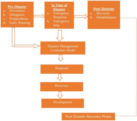
Reconstruction of the development of disaster mitigation policies for land fires based on the disaster management continuum model includes: (1) planning consisting of recognizing disaster risks, compiling disaster risk studies and maps, compiling evacuation plans; (2) organizing consisting of forming community volunteers, and emergency communication and coordination systems; (3) actuating consisting of contingency plan studies, and early warning system simulations and evacuation plans; (4) controlling consisting of early warning system development and socialization and dissemination. A hypothetical reconstruction of the development of the model can be seen in the Figure 3.
Figure 3. Hypothetical fire disaster mitigation policy development model using the disaster management continuum model method
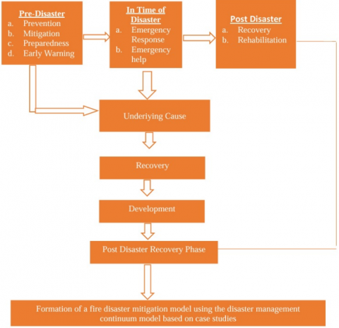
The hypothetical model above is a form of land fire disaster mitigation policy development using the disaster management continuum; its implementation produces novelty in land fire disaster mitigation in Solok Regency. Furthermore, hypothetically, the reconstruction of the model can be seen in the Figure 4.
Figure 4. Land fire disaster mitigation policy development reconstruction model
The stages begin with designing a contingency plan that includes evacuation procedures, fire handling, and division of responsibilities between various parties. Training and simulations are carried out through routine officers and the community training regarding fire management and evacuation simulations. Meanwhile, for safe zones and evacuation routes, identification and design of safe zones and evacuation routes are required to be clear and easily accessible. The steps for implementing land fire disaster mitigation disaster management continuum model are as follows: (1) Emergency, (2) relief, (3) rehabilitation, (4) mitigation, (4) preparedness, (5) early warning, (6) Response, (7) Underlying Causes, (8) Recovery, (9) Development and (10) Post Disaster Recovery Phase.
Emergency management by developing land fire disaster mitigation policies based on the disaster management continuum model in Solok Regency involves an in-depth analysis of previous fire events and implementing specific strategies to overcome challenges and mitigate future risks. The following are the steps to design and implement the plan. For the procedure for developing a policy model, see the Table 4.
Table 4. Procedures for implementing disaster mitigation policy development
|
Analysis |
Disaster Management Planning |
Implementation and Execution |
Monitoring and Evaluation |
Documentation and Reports |
|
Fire Case Identification
|
Plan Objectives:
|
|
|
|
|
Impact Assessment
Estimate the impact on communities, such as loss of livelihoods, public health, and infrastructure damage. |
Mitigation Strategy:
Enforce regulations regarding open burning and safe farming practices. |
|
|
|
|
|
Preparedness Plan:
|
|
|
|
|
|
Emergency Response Plan:
|
|
|
|
|
|
Recovery Plan:
|
|
|
|
The Biggest Impact of Land Fires on Ecosystems is that land fires significantly impact the ecosystem in the area. This can be seen from the loss of vegetation, a habitat for many species. When a fire occurs, trees and plants growing in the region will burn, reducing the availability of food and shelter for local fauna. In addition, fires damage the soil, which affects its quality and fertility. Burned soil becomes more susceptible to erosion, which triggers further problems such as river pollution due to landslides.
Land fires have a very detrimental impact on the local ecosystem. The loss of vegetation causes habitat loss for many species and disrupts the balance of the food chain. Soil damage from fires worsens soil fertility and increases its vulnerability to erosion, which can cause river pollution and landslides. Thus, the impact of land fires is not only limited to the burned area, but can also be long-term and widespread, disrupting the balance of the ecosystem as a whole and increasing the vulnerability of the environment to various other environmental problems.
In Solok Regency, many species of flora and fauna depend on forest and wetland ecosystems. When these habitats burn, many species are forced to move or even face the risk of extinction. Land fires often result in the loss of natural habitat for various species, which is detrimental to the local ecosystem. This forces many species to move into areas that may be limited or less suitable as new habitats. For some species, especially those with specific or limited habitats, fires can cause significant population declines or even local extinctions. With the loss of natural habitat, the balance of the ecosystem is disrupted, and the sustainability of biodiversity in the area is threatened. Disturbance to the Food Chain: Fires can disrupt the food chain network. Herbivorous animals lose their food sources, which has an impact on their predators.
After a fire, burned land often allows invasive species to grow, which can compete with local species. These invasive species are usually more aggressive and can dominate the area, threatening existing biodiversity. As part of the food chain, herbivorous animals that depend on plants will lose their food supply after a fire. This then impacts predators that rely on herbivores for their prey. When the herbivore population decreases, predators will also have difficulty finding food, which can lead to a decrease in predator species. As a result, the balance of the ecosystem can be disrupted, triggering the uncontrolled growth of other species. In addition, after a fire, burned land often allows invasive species to grow. These invasive species are usually more aggressive and can compete with native species, even dominating the area. These invasive species threaten biodiversity and can disrupt the stability of existing ecosystems. On the other hand, fires also affect soil quality by changing its structure and composition. Burned land becomes more susceptible to erosion and pollution, which inhibits future plant growth. Without thriving vegetation, species that depend on plants for survival are threatened, and ecosystem recovery becomes increasingly complex.
Local governments often issue regulations and policies to regulate land use and burning practices and enforce laws against violations. Establishing Firefighting Routes Firefighting routes and access points for firefighters have been established in some fire-prone areas. This makes it easier for firefighters to respond quickly when a fire occurs. Monitoring and Surveillance The application of monitoring technologies, such as satellite monitoring and fire detection systems, helps identify hotspots and predict potential fires before they spread. Establishing policies is essential to reducing the impact of land fires. Governments often issue regulations that regulate land use and burning practices and enforce laws against violations of these rules. These policies aim to limit illegal land clearing and ensure that human activities do not cause excessive environmental damage. In addition, establishing firefighting routes and strategic access points is also an essential step in handling fires more effectively. Firefighting routes built in fire-prone areas make it easier for firefighters to respond quickly and control fires before they spread further. Technology also plays a significant role in fire management through monitoring and surveillance. Advanced satellite monitoring and fire detection systems help identify hotspots faster and predict potential fires before they become major threats. With this approach, governments can plan more effective prevention and response measures, minimizing the environmental and social damage caused by fires.
Based on the findings derived from the analysis and reconstruction of the evolution of disaster mitigation policies, which are anchored in the disaster management continuum model within the context of Solok Regency, it can be inferred that the reconstruction of the development of land fire disaster mitigation policies, as informed by the disaster management continuum model, is concentrated on several critical dimensions, specifically: (1) planning, which encompasses the identification of disaster risks, the formulation of disaster risk assessments and cartographic representations, as well as the development of evacuation strategies; (2) organizing, which involves the establishment of community volunteer groups and the implementation of systems for emergency response communication and coordination; (3) mobilization, which includes the examination of contingency plans, alongside the execution of simulations for early warning systems and evacuation protocols; (4) control, which pertains to the enhancement of early warning systems, in addition to the processes of socialization and dissemination. The practical ramifications of this policy indicate that the resultant mitigation model can devise land fire disaster mitigation policies with greater comprehensiveness by prioritizing reducing risks faced by both the community and the environment. The theoretical implications suggest that this model serves as a pertinent framework for relevant research and subsequent inquiries, such as incorporating novel elements into the framework or conceptualization of the model. The advancement of a land fire disaster mitigation model may function as an initiative to furnish education to the community concerning land fire incidents, thereby mitigating the potential for significant losses; the case study methodology facilitates an in-depth comprehension of local contexts, including geological, climatic, and socio-economic attributes that are unique to a given region. This approach aids in the formulation of more pertinent and efficacious mitigation strategies, as real events can be analyzed by scrutinizing past disaster occurrences, allowing learners to grasp the application of mitigation strategies in real-world scenarios and to identify both the deficiencies and the successes that have transpired, thereby enabling an evaluation of effectiveness.
Subsequent investigations may yield insights into the efficacy of the mitigation strategies employed in specific contexts while documenting the advantages and disadvantages inherent in the methodologies applied. The ongoing enhancement of this information can refine mitigation techniques, update existing policies, and foster the development of superior best practices for future endeavors.
The Research Team appreciates and thanks the Universitas Negeri Padang for conducting this research.
[1] Martanto, C., Aji, A., Parman, S. (2017). Study of community preparedness in facing fire disasters in Kembangsari Village, Central Semarang District. Edu Geography, 1(2): 10-17. https://journal.unnes.ac.id/sju/edugeo/article/view/15389
[2] Sari, F. (2022). Identifying anthropogenic and natural causes of wildfires by maximum entropy method-based ignition susceptibility distribution models. Journal of Forestry Research, 34(2): 355-371. https://doi.org/10.1007/s11676-022-01502-4
[3] Wang, T., Zhou, D., Wang, L., Wu, J. (2023). Urban spatial carrying capacity and sustainable urbanization in the middle east section of the north slope of the Kunlun Mountains in Xinjiang, China. Chinese Geographical Science, 33(3): 1-15. https://doi.org/10.1007/s11769-023-1348-y
[4] Wang, Z., Fu, B., Wu, X., Li, Y., Wang, S., Lu, N. (2023). Escaping social–ecological traps through ecological restoration and socioeconomic development in China's Loess Plateau. People and Nature, 5(4): 1364-1379. https://doi.org/10.1002/pan3.10513
[5] Mammalogy, A. (2022). The potency of eco-innovation, natural resources, and financial development on ecological footprint: A quantile-ARDL-based evidence from China. Environmental Science and Pollution Research, 29(33): 50675-50685. https://doi.org/10.1007/s11356-022-19471-w
[6] Magliocca, N.R., Ellicott, E., Ingalls, M., Epprecht, M., Hett, C., Nanhthavong, V., de Bremond, A. (2022). Spatio-temporal unevenness in local land system regime shifts caused by land deals in Lao PDR. Ecology and Society, 27(4): 7. https://doi.org/10.5751/es-13405-270407
[7] Xu, C., Hu, X., Liu, Z., Wang, X., Tian, J., Zhao, Z. (2023). Predicting the evolution trend of water and land resource carrying capacity based on CA–Markov model in an arid region of Northwest China. Sustainability, 15(2): 1269. https://doi.org/10.3390/su15021269
[8] Genova, P., Wei, Y. (2023). A socio-hydrological model for assessing the Maipo River basin's water resource allocation and environmental regulations. Journal of Hydrology, 617: 129159. https://doi.org/10.1016/j.jhydrol.2023.129159
[9] Mecking, C. (2022). Establishment of an ecological security pattern under arid conditions based on ecological carrying capacity: A case study of an arid area in Northwest China. Sustainability, 14(23): 15799. https://doi.org/10.3390/su142315799
[10] Wu, Z., Su, Y., Xiong, M. (2022). Land comprehensive carrying capacity and spatio-temporal analysis of the Guangdong-Hong Kong-Macau Greater Bay Area. Frontiers in Environmental Science, 10: 964211. https://doi.org/10.3389/fenvs.2022.964211
[11] Roy, P., Paul, S., Chakrabortty, R., Islam, A.R.M.T., Chowdhuri, I., Saha, A. (2022). Impact of ineffective measures on the increasing land degradation in a monsoon-dominated region of India: Issues and policy implications. Land Degradation & Development, 33(16): 3174-3185. https://doi.org/10.1002/ldr.4380
[12] Sanogo, K., Birhanu, B., Sanogo, S., Ba, A. (2023). Landscape pattern analysis using GIS and remote sensing to diagnose soil erosion and nutrient availability in two agroecological zones of Southern Mali. Agriculture & Food Security, 12(1): 4. https://doi.org/10.1186/s40066-023-00408-6
[13] Schillaci, C., Jones, A., Vieira, D., Munafò, M., Montanarella, L. (2022). Evaluation of the United Nations Sustainable Development Goal 15.3.1 indicator of land degradation in the European Union. Land Degradation & Development, 34(1): 250-268. https://doi.org/10.1002/ldr.4457
[14] Sourn, T., Pok, S., Chou, P., Nut, N., Theng, D., Prasad, P.V. (2022). Assessment of land use and land cover changes on soil erosion using remote sensing, GIS and RUSLE model: A case study of Battambang Province, Cambodia. Sustainability, 14(7): 4066. https://doi.org/10.3390/su14074066
[15] Okolelova, A.A., Glinushkin, A., Sviridova, L.L., Podkovyrov, I., et al. (2022). Biogeosystem technique (BGT*) methodology will provide semiarid landscape sustainability (A case of the South Russia Volgograd Region Soil Resources). Agronomy, 12(11): 2765. https://doi.org/10.3390/agronomy12112765
[16] Pricope, N.G., Daldegan, G.A., Zvoleff, A., Mwenda, K.M., Noon, M., López-Carr, D. (2022). Operationalizing an integrative socio‐ecological framework in support of global monitoring of land degradation. Land Degradation & Development, 34(1): 109–124. https://doi.org/10.1002/ldr.4447
[17] Liang, S. (2023). Local full-sector land uses influenced by multi-regional demand and supply: The case of Beijing. Ecosystem Health and Sustainability, 9: 0075. https://doi.org/10.34133/ehs.0075
[18] Wan, Y., Zhong, Y., Ma, A., Hu, X., Wei, L. (2022). Satellite-air-ground integrated multi-source earth observation and machine learning processing brain for tailings reservoir monitoring and rapid emergency response. Land Degradation & Development, 34(7): 1941-1959. https://doi.org/10.1002/ldr.4580
[19] Scheer, D., Schmidt, M.C., Dreyer, M., Schmieder, L., Arnold, A. (2022). Integrated Policy Package Assessment (IPPA): A problem-oriented research approach for sustainability transformations. Sustainability, 14(3): 1218. https://doi.org/10.3390/su14031218
[20] Huang, Z., Qian, L., Cao, W. (2022). Developing a novel approach integrating ecosystem services and biodiversity for identifying priority ecological reserves. Resources Conservation and Recycling, 179: 106128. https://doi.org/10.1016/j.resconrec.2021.106128
[21] Fang, C. (2022). On integrated urban and rural development. Journal of Geographical Sciences, 32(8): 1411-1426. https://doi.org/10.1007/s11442-022-2003-8
[22] Tanács, E., Vári, Á., Bede-Fazekas, Á., Báldi, A., et al. (2023). Finding the green grass in the haystack? Integrated national assessment of ecosystem services and condition in Hungary, in support of conservation and planning. Sustainability, 15(11): 8489. https://doi.org/10.3390/su15118489
[23] Souza-Alonso, P., García-Romero, D., Lorenzo Moledo, M., Merino, A. (2023). When necessity meets opportunity: The role of service-learning projects to complement training, community engagement and knowledge transfer in restoration. Restoration Ecology, 31(7): e13933. https://doi.org/10.1111/rec.13933
[24] Kgaphola, M.J., Ramoelo, A., Odindi, J., Kahinda, J.M.M., Seetal, A., Musvoto, C.D. (2023). Social–ecological system understanding of land degradation in response to land use and cover changes in the Greater Sekhukhune District Municipality. Sustainability, 15(4): 3850. https://doi.org/10.3390/su15043850
[25] Asad, R., Saleem, M., Habib, M.S., Mufti, N.A., Mayo, S.M. (2023). Seismic risk assessment and hotspots prioritization: A developing country perspective. Natural Hazards, 117(3): 1-39. https://doi.org/10.1007/s11069-023-05970-7
[26] Lin, H.S., Hsieh, C.C., Chen, D. (2023). The multiplexity of collaborative networks in post-disaster recovery: Testing intra-sector and cross-sector network contexts. Administration & Society, 55(3): 485-514. https://doi.org/10.1177/00953997221147240
[27] Hussain, M.A., Zhang, S., Moawwez, M.A., Umar, T., Iqbal, M.R., Kamran, M., Muneer, M. (2023). A review of spatial variations of multiple natural hazards and risk management strategies in Pakistan. Water, 15(3): 407. https://doi.org/10.3390/w15030407
[28] Mihunov, V. (2022). Disaster impacts surveillance from social media with topic modeling and feature extraction: Case of hurricane Harvey. International Journal of Disaster Risk Science, 13(5): 729-742. https://doi.org/10.1007/s13753-022-00442-1
[29] Tzavella, K. (2022). Volunteered geographic information use in crisis, emergency and disaster management: A scoping review and a web atlas. Geo-Spatial Information Science, 27(2): 423-454. https://doi.org/10.1080/10095020.2022.2139642
[30] Jiang, Z., Chen, Y., Ji, W., Dong, Z.S., Ji, R. (2023). Leveraging machine learning and simulation to advance disaster preparedness assessments through FEMA national household survey data. Sustainability, 15(10): 8035. https://doi.org/10.3390/su15108035
[31] George, S.K. (2022). Indicator-based assessment of capacity development for disaster preparedness in the Indian context. Environment Systems and Decisions, 42(3): 417-435. https://doi.org/10.1007/s10669-022-09856-0
[32] Parvin, G., Takashino, N., Islam, S., Rahman, H., Abedin, A., Ahsan, R. (2022). Disaster-induced damage to primary schools and subsequent knowledge gain: Case study of the Cyclone Aila-Affected community in Bangladesh. International Journal of Disaster Risk Reduction, 72: 102838. https://doi.org/10.1016/j.ijdrr.2022.102838
[33] Khan, M.A., Hasan, K., Kabir, K.H. (2022). Determinants of households’ livelihood vulnerability due to climate-induced disaster in southwest coastal region of Bangladesh. Progress in Disaster Science, 15: 100243. https://doi.org/10.1016/j.pdisas.2022.100243
[34] Cañón-Barriga, C.C., Bogardi, J.J., Tischbein, B. (2022). Prioritizing neighborhoods for intervention to mitigate urban small disasters triggered by rainfall. Urban Water Journal, 20(10): 1672-1681. https://doi.org/10.1080/1573062x.2022.2026981
[35] Mavroulis, S., Mavrouli, M., Kourou, A., Thoma, T., Lekkas, E. (2022). Multi-hazard emergency response for geological hazards amid the evolving COVID-19 pandemic: Good practices and lessons learned from earthquake disaster management in Greece. Sustainability, 14(14): 8486. https://doi.org/10.3390/su14148486
[36] Mesta, C., Cremen, G., Galasso, C. (2023). Quantifying the potential benefits of risk-mitigation strategies on future flood losses in Kathmandu Valley, Nepal. Natural Hazards and Earth System Sciences, 23(2): 711-731. https://doi.org/10.5194/nhess-23-711-2023
[37] Gonzalez-Duenas, C., Meads, M.M., Padgett, J.E., Highfield, W.E. (2023). Knowledge-informed data-driven modeling of coupled human-built–natural systems: The case of hurricane-induced debris. Natural Hazards Review, 24(2). https://doi.org/10.1061/nhrefo.nheng-1705
[38] Alrehaili, N.R., Almutairi, Y.N., Alghamdi, H.M., Almuthaybiri, M.S. (2023). The need for emergency management models. Journal of Emergency Management and Disaster Communications, 4(1): 17-31. https://doi.org/10.1142/s2689980923500021
[39] Douthat, T.H., Akhter, F., Sanderson, R.L., Penn, J. (2023). Stakeholder perceptions about incorporating externalities and vulnerability into benefit–cost analysis tools for watershed flood risk mitigation. Sustainability, 15(9): 7473. https://doi.org/10.3390/su15097473
[40] Hadlos, A., Opdyke, A., Hadigheh, S.A. (2022). Where does local and indigenous knowledge in disaster risk reduction go from here? A systematic literature review. International Journal of Disaster Risk Reduction, 79: 103160. https://doi.org/10.1016/j.ijdrr.2022.103160
[41] Nakum, V.K., Ahamed, M.S., Isetani, S., Chatterjee, R., Shaw, R., Soma, H. (2022). Developing a framework on school resilience for risk-informed decision-making. Progress in Disaster Science, 15: 100237. https://doi.org/10.1016/j.pdisas.2022.100237
[42] Rufat, S., Robinson, P.J., Botzen, W.J.W. (2023). Insights into the complementarity of natural disaster insurance purchases and risk reduction behavior. Risk Analysis, 44(1): 141-154. https://doi.org/10.1111/risa.14130
[43] Wanner, M.S.T. (2022). Change in policy regimes for disaster risk reduction in Fiji and Nepal. International Journal of Disaster Risk Reduction, 77: 103030. https://doi.org/10.1016/j.ijdrr.2022.103030
[44] Alhadi, Z., Riandini, O., Yusran, R., Eriyanti, F., Putera, R.E. (2024). Policy design for strengthening disaster risk reduction based on Sendai framework for action in West Sumatera Province, Indonesia. International Journal of Safety & Security Engineering, 14(6): 1895-1905. https://doi.org/10.18280/ijsse.140623
[45] Alhadi, Z., Riandini, O., Eriyanti, F., Yusran, R., Permana, I. (2024). Analysis of the effectiveness and efficiency of tsunami disaster contingency planning policies in the province of West Sumatra, Indonesia. International Journal of Safety & Security Engineering, 14(4): 1087-1098. https://doi.org/10.18280/ijsse.140407
[46] Stern, P.C., Dietz, T., Vandenbergh, M.P. (2022). The science of mitigation: Closing the gap between potential and actual reduction of environmental threats. Energy Research and Social Science, 91: 102735. https://doi.org/10.1016/j.erss.2022.102735
[47] Foghagen, C., Alriksson, S. (2023). Mitigation of water shortage impacts among tourism and farming companies on the islands of Öland and Gotland, Sweden. Environment, Development and Sustainability, 26(3): 7509-7527. https://doi.org/10.1007/s10668-023-03019-0
[48] Alhadi, Z., Rahman, A., Yusran, R., Yuliarti. (2024). Policy analysis for handling environmental damage based on disaster mitigation in Nagari Air Dingin, Solok Regency. International Journal of Environmental Impacts, 7(4): 769-780. https://doi.org/10.18280/ijei.070417
[49] Berg, T.A., Kintziger, K.W. (2023). The application of model-based systems engineering to rural healthcare system disaster planning: A scoping review. International Journal of Disaster Risk Science, 14(3): 1-12. https://doi.org/10.1007/s13753-023-00492-z
[50] Immanuel, R.R. (2023). Improving flood early warning systems in Kabbe, Namibia: A situational analysis approach. International Journal of Disaster Risk Reduction, 93: 103765. https://doi.org/10.1016/j.ijdrr.2023.103765
[51] Alhadi, Z., Sasmita, S., Yulfa, A., Fatimah, S., Syafrini, D., Maani, K.D., Riandini, O. (2023). The coping strategies patterns based on local wisdom and resilience capital in facing natural disaster risk in Nagari Mandeh, Indonesia. International Journal of Sustainable Development & Planning, 18(1): 315-325. https://doi.org/10.18280/ijsdp.180133
[52] Fatmah, F. (2019). Community-based fire mitigation model: A qualitative study on government officials and NGOs. Kesmas: National Public Health Journal, 4(3): 99. https://doi.org/10.21109/kesmas.v4i3.18
[53] Salwa Salsabila, W., Rafa Dinda, R. (2021). Disaster mitigation learning in elementary schools with demonstration methods. Proceedings Series on Social Sciences & Humanities, 1: 115-120. https://doi.org/10.30595/pssh.v1i.83
[54] Hilman, Y.A. (2018). Disaster management concept of muhammadiyah disaster management centre in Ponorogo, Indonesia. Jurnal Otoritas, 8(1): 65-81. https://doi.org/10.26618/ojip.v8i1.807
[55] Brewer, C.A., Hutton, A., Hammad, K.S., Geale, S.K. (2020). A feasibility study on disaster preparedness in regional and rural emergency departments in New South Wales: Nurses self-assessment of knowledge, skills and preparation for disaster management. Australasian Emergency Care, 23(1): 29-36. https://doi.org/10.1016/j.auec.2019.12.005
[56] Maguire, B. (2018). Disasters and communities understanding social resilience. The Australian Journal of Emergency Management, 22(2): 16-20.
[57] Kelly, C. (1998). A review of contributions to disasters: 1977—1996. Disasters, 22(2): 144-156. https://doi.org/10.1111/1467-7717.00082
[58] Pashaei Asl, Y., Dowlati, M., Babaie, J., Seyedin, H. (2022). Integrated operations for natural disaster management: A systematic review. Health Promotion Perspectives, 12(3): 266-272. https://doi.org/10.34172/hpp.2022.33
[59] Rodríguez-Espíndola, O. (2023). Two-stage stochastic formulation for relief operations with multiple agencies in simultaneous disasters. Or Spektrum, 45(2): 477-523. https://doi.org/10.1007/s00291-023-00705-3
[60] Kwon, J.W., Yun, S., Kim, W.T. (2022). A semantic data-based distributed computing framework to accelerate digital twin services for large-scale disasters. Sensors, 22(18): 6749. https://doi.org/10.3390/s22186749
[61] Joo, S., Ogawa, Y., Sekimoto, Y. (2022). Road-reconstruction after multi-locational flooding in multi-agent deep RL with the consideration of human mobility - Case study: Western Japan flooding in 2018. International Journal of Disaster Risk Reduction, 70: 102780. https://doi.org/10.1016/j.ijdrr.2021.102780
[62] Ries, M. (2022). Global key concepts of civil-military cooperation for disaster management in the COVID-19 pandemic—A qualitative phenomenological scoping review. Frontiers in Public Health, 10: 975667. https://doi.org/10.3389/fpubh.2022.975667
[63] Pickard, A.J. (2013). Research Methods in Information. Facet Publishing.