Muladi*![]() | I Made Wirawan
| I Made Wirawan![]() | Dyah Lestari
| Dyah Lestari![]() | Sebastian Choirul El Raka | Alvandi Brilian Leksono | Febrianto A. Qodri | Singgih Dwi Prasetyo
| Sebastian Choirul El Raka | Alvandi Brilian Leksono | Febrianto A. Qodri | Singgih Dwi Prasetyo![]()
© 2025 The authors. This article is published by IIETA and is licensed under the CC BY 4.0 license (http://creativecommons.org/licenses/by/4.0/).
OPEN ACCESS
Landslides are one of the disasters that are increasing in incidence along with climate change. Hilly areas that have experienced a change in designation from forest to agricultural or residential have low soil resilience. High rainfall easily triggers landslides. Early warning is a preventative effort to avoid and reduce the impacts caused by disasters. Remote monitoring using the Internet of Things helps in the early detection of catastrophes. However, remote mountainous areas need more internet network infrastructure. LoRa technology connects sensor networks in blank spot areas with the internet network via cellular internet to form LoRAWAN. Using the Chirpstack platform, the system responds quickly to changes in the location of sensor nodes, which are signs of ground movement. The system uses two sensor nodes: three weather nodes and six ground nodes. Soil moisture as an indicator of soil saturation before moving can be detected accurately using capacitive or resistive sensors. Ground movements can be detected and identified quickly in the monitoring system within 0.17 seconds using vibration and displacement sensors. The novelty of this study lies in integrating the Chirpstack-based LoRaWAN platform, which allows for rapid, reliable, and energy-efficient landslide monitoring in remote regions. This work significantly contributes to disaster mitigation efforts, especially in areas with limited internet connectivity.
Chirpstack, LoRAWAN, land sliding, monitoring
Global climate change, characterized by changes in the pattern and intensity of climate elements, has brought weather changes in Indonesia [1]. One is high rainfall over a reasonably long period, causing flooding in several areas that floods had never hit [2]. High rainfall also causes flash floods and landslides in highlands and mountainous regions [3]. This disaster is also supported by a decline in land quality due to agriculture, deforestation, or changes in land use, such as housing. High rainfall causes land saturation and landslides because it cannot accommodate the rainwater it receives [4].
Landslide disasters are initiated by translational, rotational, block movement, rockfall, creeping, and debris flows [5]. Landslides can occur over a period varying from short to long term. The opportunity for landslides to occur can also be seen from the causes of landslides originating from human activities, changes in soil morphology, and geological factors. Identification of causal factors and early detection of landslides can prevent disasters or reduce the impacts [6]. Predictions using real-time monitoring data processed with machine computing can provide accurate information about the potential and opportunity for landslides to occur [7]. Despite various landslide studies, limited research focuses on real-time and energy-efficient monitoring in remote Indonesian regions, which this study aims to address.
Monitoring and early detection of landslides aims to avoid (mitigate) disasters to minimize their impact [8]. In 2022, there will be 629 landslides causing 318 victims, 459 people displaced, and 892 buildings damaged, most of which occurred on the island of Java. The number of disasters was more significant in previous years, namely in 2020 and 2021, respectively, amounting to 2099 and 1321 incidents [9]. The impact of disasters can be minimized through early warning and efforts to prevent disasters [10, 11].
Early warning of landslides is carried out by monitoring land and weather conditions in disaster-prone areas [12, 13]. Using wireless sensor networks (WSN) and Internet of Things (IoT) technology, monitoring land and the environment accurately and in real-time can provide complete and detailed data. Data processing using cloud computing and machine learning algorithms produces fast and accurate information [14]. WSN and IoT-based landslide monitoring has been carried out using WiFi communications and GSM cellular data combined with edge computing [7], Zigbee [15, 16], and Zigbee-LoRa [17]. Landslide monitoring and detection involves large mountainous areas far from electricity and communications network infrastructure, so selecting the right technology is essential.
This article will explain the development of a monitoring and early detection system for landslides using WSN based on LoRAWAN and NB-IoT. The sensor uses GPS-based coordinate sensors for movement, sound, rainfall, wind, air temperature, and soil moisture. These parameters are censored and produce small data according to the characteristics of LoRa communication. An edge server on the gateway is added to process initial data before sending it to the cloud network server. The monitoring application is provided via a cloud application server and accessed via the internet using a desktop computer or Android device. Contributions of this article are:
-The landslide monitoring system integrates weather and soil condition monitoring using cheap, low-energy devices and long-distance communications. The system architecture provides accurate and quick monitoring.
-Changes in location as a sign of land shifts in landslides are detected using changes in the position of sensor nodes based on data from the accelerometer sensor. These changes can be detected quickly compared to GPS systems, which require internet communication with the GPS server.
-Sensor nodes using LoRa SX1278 are integrated with STM32 microcontrollers to communicate between sensor nodes and gateways equipped with AES data security.
-Gateway using LoRa SX1302 incorporated with mini-computer using MT7628 processor and 32MB RAM in a Chirpstack package Sensecap M2.
An IoT and LoRa-based monitoring system has been developed to prevent landslides. Arduino and LoRa SX1278 have been used for IoT-based real-time monitoring [18]. The Arduino's computing capabilities are low, and the LoRa SX1278 device provides point-to-point communication. This architecture [18] and others [17, 19] do not use controller nodes as gateways, so the monitoring system cannot implement end-to-end data security mechanisms. Guidelines for designing, implementing, and testing wireless networks have been developed to produce robust monitoring systems [20]. The gateway on the LoRAWAN network provides multiple access from sensor nodes with a controller node that forwards sensor data to the cloud server via the cellular internet network [21]. This LoRAWAN and IoT-based sensor network is also used for intelligent flood monitoring [22]. Cloud-based landslide detection to provide early warning has been developed with IoT technology [23] and sensors [24].
Landslides are a disaster that occurs in highland areas, namely mountains and hills. As an archipelagic country located in the world's Ring of Fire, Indonesia has many mountainous regions prone to landslides. The potential for landslides is supported by Indonesia's geographical location on the equator, which has a tropical climate with high rainfall. Global climate change has caused increased rain in Indonesia (1). The number of landslide incidents in 2020 was 2099; in 2021, it was 1032; and in 2022, it was 639. Even though the number of incidents shows a decrease, the impact is getting more extensive both in terms of the number of fatalities and the level of loss. Some of the most affected regions include West Java, Central Java, and Sumatra, where steep slopes, deforestation, and high rainfall contribute to frequent landslides. These areas are particularly vulnerable due to rapid urbanization, unsustainable land use, and geological instability.
In a landslide event, a large amount of soil moves from one place to another at a lower position. This movement will cause sound, changes in the land's surface, and the movement of large amounts of material. Land movement, soil conditions, the surrounding environment, and weather are parameters used to determine the potential for landslides to occur. Monitoring rainfall and its limits is the main factor that causes landslides, which is heavy rain [25, 26]. Rainfall data is collected and analyzed to find patterns and boundaries that indicate when the soil becomes saturated and unstable [27, 28]. Landslide warnings can be activated when rainfall exceeds a specific limit. Likewise, sudden changes or acceleration in ground movement can signify an impending landslide. Geological and geomorphological mapping is based on past events and slope conditions. Geological and geomorphological mapping of an area can help identify areas prone to landslides. It is more likely for steep slopes, loose soil, and certain rock formations. Another method used to detect landslides is remote sensing and satellite imaging. Remote sensing [29] and satellite imaging [30] Can offer observations on changes in land surface, vegetation, and topography that may indicate possible instability-seismic monitoring through seismic signals produced by landslides [31]. Monitoring seismic activity in an area can provide early warning of impending landslides. The following method checks soil moisture and infiltration rate. These two parameters help us understand how much water the soil can absorb before it becomes unstable. LiDAR technology [32, 33] can be determined by providing a detailed elevation model of the slope based on the steepness and characteristics of the hill.
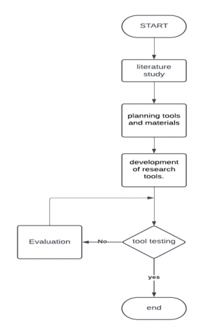
4.1 Research flow
Based on Figure 1, the first is to conduct a literature study to understand landslides in Indonesia by reading several previous or related research journals, then preparing materials and sensors such as soil, weather sensors, and IoT; after the tools and materials are designed by connecting the battery to the component. Where solar panels supply the battery. Then, the tool is tested by comparing it with the actual value; if the results are by the research objectives, then it is successful, and if not, then an evaluation is carried out.
4.2 Development of research tools
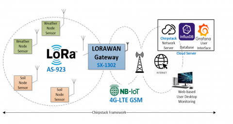
The hardware used in the developed system is based on the LoRAWAN stack topology at the physical and data link layers, as depicted in Figure 1. The star topology of the LoRa network ensures that the LoRa gateway can receive and send chirp signals to all existing sensor nodes so that there is no routing process on the sensor node network. The hardware generally consists of a processing unit (microcontroller or microprocessor), sensors, communication devices (LoRa transceiver, LoRa multichannel gateway, WiFi, and 4G modem), and power supply. Cloud server devices use infrastructure-based cloud services configured directly over secure communication channels (SSL). The hardware specification is described as follows.
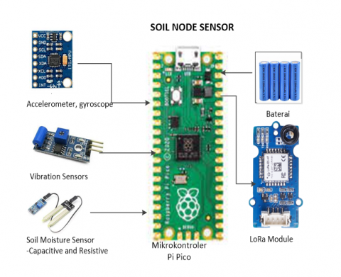
Power consumption is a consideration because sensor nodes use limited energy sources of batteries. Battery life and replacement can be carried out longer if energy-efficient devices are used. The microcontroller chosen is a Raspberry Pi Pico, which uses the RP2040 chip. This microcontroller has a dual-core Cortex M0+ processor with a flexible clock running up to 133MHz, 264kB SRAM, and 2MB on-board flash memory. The USB 1.1 port is used to communicate with the host to enter the operating system and write programs that support file drag-drop. This microcontroller interface is provided via 26 GPIO pins of 2 SPI, 2 I2C, three 12-bit ADCs, and 16 controllable PWM channels-low power consumption in sleep and dormant conditions and an accurate clock and timer on the chip.
Sensors are used to measure parameters related to landslides, which are grouped into two parts: parameters related to weather and parameters related to soil conditions. Weather parameters are calculated by weather sensor nodes, and soil parameters are measured by soil sensor nodes, which are sensor nodes in the Internet of Things (IoT) system topology. Weather sensor nodes measure rainfall using a tipping-type ombrometer, wind speed using a hemispherical-cup type anemometer, air (temperature, humidity, and pressure) using BME280, and light intensity using BH1750.
The second sensor node in the system is a soil sensor node as a sensor, which functions to monitor soil conditions and movements. Parameters monitored include soil saturation level, soil movement, and position. The soil sensor node is mounted on a base that is easy to move following the movement of the soil beneath it. The soil saturation level is measured based on the level of soil moisture using a soil moisture sensor. The water content in the soil, which determines the humidity level, is detected by the sensor through changes in the resistance value between the probe legs. The higher the water content, the smaller the resistance between the probes since water is conductive to electrical currents. Land shifts are an initial sign of a landslide and are detected based on movement, speed of movement, and distance moved. This position change parameter is measured using an ADXL345 accelerometer, ITG3200 gyroscope, and HMC5883L as a magnetometer/barometer integrated into the GY85 sensor module. The ground sensor nodes integrate accelerometer, gyroscope, and magnetometer/barometer data to detect changes in position accurately. The GY85 sensor module collects raw data from the accelerometer (ADXL345) for displacement detection, the gyroscope (ITG3200) for angular velocity measurement, and the magnetometer/barometer (HMC5883L) for altitude changes. Combining these three sensors ensures precise ground movement monitoring, distinguishing between minor vibrations and significant shifts that indicate landslide potential. Changes in the position of the ground sensor node are detected by an accelerometer, which corrects the initial position of the ground sensor node. The horizontal shift value (x and y axes) is added to the initial latitude and altitude position. The process is much faster compared to updating positions using GPS. The vertical location shift (z-axis) is combined with the height change of the barometer to update the vertical position of the node. The soil sensor node uses double 3000mAh 18650 batteries. Under normal conditions, each sensor node consumes approximately 0.2W, allowing for continuous operation for up to 6 months before requiring battery replacement or recharging via solar panels. Soil sensor nodes are light in weight and free from other objects around them, making them easy to move when the ground beneath them shifts.
The weather and ground sensor nodes send data to the LoRAWAN gateway using the 915MHz LoRa network within the AS923 Standard. The gateway is a concentrator of the LoRa network of sensor nodes and has a connection to the internet. Connection to the internet is served via a narrowband IoT cellular network (NB-IoT), wireless LAN (wifi), or ethernet, depending on the availability of internet access infrastructure at the gateway placement location. The gateway consists of a multichannel LoRa module, which can receive LoRa signals from several sensor nodes simultaneously, and an MT7628 mini-computer, which controls communications using the LoRAWAN protocol. The computer uses Chirpstack Gateway OS as an open operating system based on OpenWRT. This system consists of three components: concentrator, MQTT Forwarder, and UDP Forwarder. The gateway communicates bidirectionally with sensor nodes using the MQTT protocol and with the cloud server via the internet network using the UDP protocol. Therefore, the LoRa communication devices on the sensor nodes are configured to communicate with the MQTT protocol, and the cloud server provides access via the UDP protocol. The LoRa communication device on the sensor node uses the LoRa SX1302 chip at 915MHz (within AS923 Standard). LoRa devices used in LoRAWAN are grouped into three classes: A, B, and C, based on the transmit and receive methods in bi-directional communication. Class A devices divide communication slots into transmit, receive 1, and receive 2. Each receive phase begins with a delay time longer than the time to receive the packet, as shown in Figure 2. Class A is used for environmental monitoring and detection-forest fires, water leak detection, etc. In the landslide monitoring system, data transmission is only carried out by uplink from the sensor node to the network server via the LoRAWAN gateway. Time slots are allocated to transmit or uplink Tx and are not assigned to receive or downlink Rx. The sensor node sends one data packet and remains silent for 10 ms before the subsequent packet transmission. The upgrade-over-the-air (UOTA) feature allows the transmission mode to be changed via the network.
The UDP Forwarder function of the LoRAWAN Gateway is used to send data packets to the cloud server via the GSM data communication network. The NB-IoT GSM module used in this monitoring system is SIM7020C. The uplink speed of this modem is 62.6kbps, and the downlink is 26.1kpbs with a low power consumption of 5 uA at a voltage of 3.6V, which is by the characteristics of the LoRa sensor network. The sensor node circuit and LoRAWAN gateway are shown in Figure 3. Once the gateway receives the data via LoRAWAN, it undergoes several processing stages before being transmitted to the cloud server. The process starts with the LoRa Packet Forwarder, which decapsulates the LoRa packet and forwards it to the Chirpstack Network Server (CNS) using the MQTT protocol. The CNS authenticates, decodes, and filters the data before sending it to the Chirpstack Application Server (CAS). The processed data is converted into JSON format at the CAS level and transmitted to the cloud server via REST API or MQTT broker. The cloud server utilizes a NoSQL database such as InfluxDB to store historical data and employs a Grafana-based dashboard for real-time monitoring. To ensure secure and reliable communication, the system implements Advanced Encryption Standard (AES-128) for communication between the sensor nodes and the gateway. Meanwhile, the Transport Layer Security (TLS) protocol is used between the gateway and the cloud server to encrypt data during transmission.
Figure 1. Research flow diagram of Chirpstack-based LoRAWAN platform for land-sliding monitoring system
Figure 2. Topology of monitoring system based on Chirpstack LoRAWAN framework [34]
Figure 3. One-way communication scheme of LoRa model A devices in monitoring applications [35]
5.1 Sensor sensitivity
Sensor nodes are an essential part of the monitoring system responsible for data collection accuracy, and each sensor is calibrated to produce correct measurements. The measurement method used by the sensor affects its sensitivity level. Measuring soil water content to determine the soil saturation level influences the potential for landslides [27, 35]. Measurement trials were carried out with capacitive or resistive sensor types, as shown in Figure 4. Resistive sensors are more sensitive at low humidity levels to detect changes in the measured object.
The accelerometer sensor is used to detect the movement of the ground sensor node when the ground beneath it moves. Changes in the direction of the x and y axes cause a shift in position, while changes in the z-axis have an impact on the vertical position. Figure 5 shows that the displacement of the ground sensor node position was measured accurately with an error of 4%. This error was compared with the actual value using the following formula. The displacement sensing performance presented in Figure 6 depicts a great correlation between actual values and sensor values with negligible errors.
(a)
(b)
Figure 4. Node sensor, (a) weather, (b) soil
Figure 5. Soil moisture sensor performance
Figure 6. Displacement sensing
Percentage Relative Error =(∣ Measured Value − True Value ∣∣ True Value ∣)×100% (1)
5.2 LoRa performance
Disaster monitoring requires fast data transmission so appropriate responses can be carried out immediately. Data transmission speed using LoRa is expressed by the time of arrival (ToA), which is determined by coding rate, spreading factor (SF), and bandwidth. According to data transmission requirements, testing was conducted at a coding rate 4/8 and a bandwidth of 125kHz with an SF value of 7 to 12. The monitoring system operated for 24 hours, so testing was carried out day and night, as shown in Table 1, where ToA is expressed in ms.
5.3 Implementation scenario
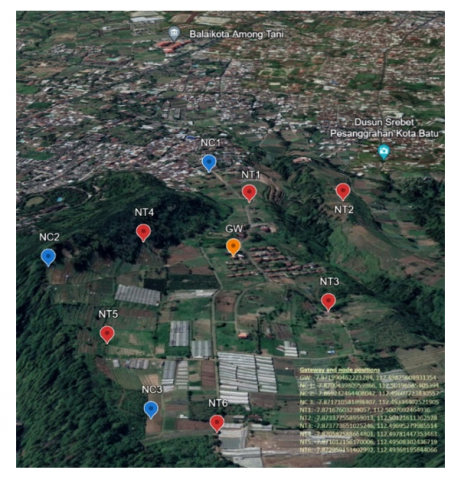
After conducting a series of tests, a monitoring system will be implemented to monitor landslide-prone areas in Songgokerto Village, Batu City. This area experiences landslides every rainy season, blocking access to the provincial roads below. Trader stalls, residential areas, and the Songgoriti tourist area are along this road. Monitoring this area is essential to minimize losses and even human casualties. The deployment included six ground sensor nodes and three weather sensor nodes, covering an area of approximately 2 km². Data was collected continuously for 6 months, with real-time monitoring accessible through a cloud-based dashboard. The location of the sensor node and gateway placement are shown in Figure 7. The placement of this system is coordinated with the National Agency for Disaster Management at Batu City (BNPB).
Tabel 1. Time of arrival LoRa performance (s)
|
SF |
|
7 |
8 |
9 |
10 |
11 |
12 |
|
ToA Avg. |
Daylight |
2.46 |
2.47 |
2.47 |
2.48 |
2.49 |
3.22 |
|
ToA Avg. |
Evening |
0.17 |
0.17 |
0.17 |
0.18 |
0.19 |
0.20 |
Figure 7. Site plan for the placement of a landslide disaster monitoring system
5.4 Challenges and limitations
Despite its effectiveness, the monitoring system faces several challenges. Regular maintenance is required to ensure sensor accuracy and prevent data loss. Additionally, harsh weather conditions, such as heavy rainfall and strong winds, can impact sensor durability. The reliability of the communication network is another concern, as intermittent connectivity in remote areas can delay data transmission. Future improvements may include the integration of edge computing to enhance real-time processing at the gateway level, reducing dependence on cloud-based data analysis.
A landslide monitoring system for disaster prevention using LoRAWAN based on Chirpstack has been developed, tested, and implemented in landslide-prone locations. The sensors work quickly and accurately, are delivered to the gateway soon, and can be monitored remotely via an application from a cloud server.
Based on these observations, it is recommended that further research should focus on increasing our understanding of landslide mechanisms using progress methodology and developing new techniques to prevent and reduce landslides. Apart from that, research is also a must to focus on the reliable and effective development of a method for monitoring and predicting the occurrence of landslides by taking rainfall data so that it can be collected and analyzed to find patterns and limits when the soil becomes very damp and unstable so that disaster mitigation can be carried out on time.
An applied research grant funded this research - the downstream pathway from the Directorate of Research, Technology and Community Service (DRTPM) of the Ministry of National Education of the Republic of Indonesia through contract No. 140/E5/PG.02.00.PL/2023 and 20.6.98/UN32.20.1/LT/2023 of 2023. Thanks are expressed to Research Partner CV Satria Angkasa Mechatronics, who also funded this research through the letter of agreement No. 10-PKS-GdC/13.IV/2023. Thank you to the National Agency for Disaster Management at Batu City, East Java, for facilitating the collection of field information.
[1] Siahaan, M. (2023). Climate change in Indonesia-statistics & facts. Statistika, (January 2007): https://www.statista.com/topics/9549/climate-change-in-indonesia/.
[2] Trenberth, K.E. (2011). Changes in precipitation with climate change. Climate Research, 47(1-2): 123-138. https://doi.org/10.3354/cr00953
[3] Mao, W., Zhang, W., Kou, M. (2023). Statistical characteristics of raindrop size distribution during rainy seasons in complicated mountain terrain. Hydrology and Earth System Sciences, 27(21): 3895-3910. https://doi.org/10.5194/hess-27-3895-2023
[4] Liu, H., Yu, P., Lu, H., Xie, Y., Wang, Z., Hao, S., Liu, H., Fu, Y. (2023). Experimental study on disaster mechanism of completely weathered granite landslide induced by extreme rainfall. Geoenvironmental Disasters, 10(1): 5. https://doi.org/10.1186/s40677-023-00234-9
[5] von Huene, R., Miller, J.J., Dartnell, P. (2016). A possible transoceanic tsunami directed toward the US west coast from the S emidi segment, A laska convergent margin. Geochemistry, Geophysics, Geosystems, 17(3): 645-659. https://doi.org/10.1002/2015GC006147
[6] Chowdhury, R., Flentje, P. (2014). Mitigation of landslide impacts, strategies and challenges for the 21 st century. International Journal of Landslide and Environment, 2(1s): 1-13. https://ro.uow.edu.au/articles/journal_contribution/Mitigation_of_landslide_impacts_strategies_and_challenges_for_the_21st_century/27718317.
[7] Joshi, A., Grover, J., Prasanna Kanungo, D., Kumar Panigrahi, R. (2020). Real-Time landslide monitoring, detection and early warning system for tangni landslide. SSRN Electronic Journal, 1-6. https://doi.org/10.2139/ssrn.3511001
[8] Amarda, S.Y., Mahamad, A.K., Prasetyo, S.D., Harsito, C. (2024). LoRaWAN and IoT-based landslide early warning system. Acadlore Transactions on Geosciences, 3(2): 106-122. https://doi.org/10.56578/atg030205
[9] Prawiradisastra, F., Shomim, A.F., Trisnafiah, S., Khaerani, P., Tejakusuma, I.G., Zakaria, Z. (2023). Forensic assessment of landslides induced by environmental changes in Sumedang, Indonesia, an important step for the future disaster prevention. In IOP Conference Series: Earth and Environmental Science. IOP Publishing, 1201(1): 012065. https://doi.org/10.1088/1755-1315/1201/1/012065
[10] Calvello, M. (2017). Early warning strategies to cope with landslide risk. Rivista Italiana Di Geotecnica, 2(17): 63-91. https://doi.org/10.19199/2017.2.0557-1405.063
[11] Intrieri, E., Gigli, G., Casagli, N., Nadim, F. (2013). Brief communication" Landslide early warning system: toolbox and general concepts". Natural Hazards and Earth System Sciences, 13(1): 85-90. https://doi.org/10.5194/nhess-13-85-2013
[12] Arifin, Z., Suyitno, S.H., Prasetyo, S.D., Hasbi, M. (2022). Promoting effect of TiCl4 pre-coating time on TiO2 semiconductors on double layer dye-sensitized solar cell. Journal of Sustainability for Energy, 1(1): 18-26. https://doi.org/10.56578/jse010103
[13] Prasetyo, S.D., Prabowo, A.R., Arifin, Z. (2023). The use of a hybrid photovoltaic/thermal (PV/T) collector system as a sustainable energy-Harvest instrument in urban technology. Heliyon, 9(2): e13390. https://doi.org/10.1016/j.heliyon.2023.e13390
[14] Furizal, F., Sunardi, S., Yudhana, A., Umar, R. (2024). Energy efficiency with internet of things based fuzzy inference system for room temperature and humidity regulation. International Journal of Engineering, 37(1): 187-200. https://doi.org/10.5829/ije.2024.37.01a.17
[15] Srinivas, Y., Rao, K.R. (2014). Landslide warning system using Zigbee and GPS. IOSR Journal of Engineering (IOSRJEN), 4(7): 1-6. https://doi.org/10.9790/3021-04740106
[16] Butler, M., Angelopoulos, M., Mahy, D. (2019). Efficient IoT-Enabled landslide monitoring. In 2019 IEEE 5th World Forum on Internet of Things (WF-IoT), Limerick, Ireland, pp. 171-176. https://doi.org/10.1109/WF-IoT.2019.8767201
[17] Bagwari, S., Gehlot, A., Singh, R., Priyadarshi, N., Khan, B. (2021). Low-Cost sensor-Based and LoRaWAN opportunities for landslide monitoring systems on IoT platform: a review. IEEE Access, 10: 7107-7127. https://doi.org/10.1109/ACCESS.2021.3137841
[18] Bagwari, S., Roy, A., Gehlot, A., Singh, R., Priyadarshi, N., Khan, B. (2022). LoRa based metrics evaluation for real-time landslide monitoring on IoT platform. IEEE Access, 10: 46392-46407. https://doi.org/10.1109/ACCESS.2022.3169797
[19] El Moulat, M., Debauche, O., Mahmoudi, S., Brahim, L.A., Manneback, P., Lebeau, F. (2018). Monitoring system using internet of things for potential landslides. Procedia Computer Science, 134: 26-34. https://doi.org/10.1016/j.procs.2018.07.140
[20] Giorgetti, A., Lucchi, M., Tavelli, E., Barla, M., Gigli, G., Casagli, N., Chiani, M., Dardari, D. (2016). A robust wireless sensor network for landslide risk analysis: System design, deployment, and field testing. IEEE Sensors Journal, 16(16): 6374-6386. https://doi.org/10.1109/JSEN.2016.2579263
[21] Wang, C., Guo, W., Yang, K., Wang, X., Meng, Q. (2022). Real-Time monitoring system of landslide based on LoRa architecture. Frontiers in Earth Science, 10: 899509. https://doi.org/10.3389/feart.2022.899509
[22] Zakaria, M.I., Jabbar, W.A., Sulaiman, N. (2023). Development of a smart sensing unit for LoRaWAN-Based IoT flood monitoring and warning system in catchment areas. Internet of Things and Cyber-Physical Systems, 3: 249-261. https://doi.org/10.1016/j.iotcps.2023.04.005
[23] Gopi, B., Premalatha, J., Kalaivani, R., Ravikumar, D. (2023). Cloud based landslide detection and alerting nearby people by using IoT technology. In 2023 Third International Conference on Artificial Intelligence and Smart Energy (ICAIS), Coimbatore, India, IEEE, pp. 1287-1292. https://doi.org/10.1109/ICAIS56108.2023.10073773
[24] Gamperl, M., Singer, J., Thuro, K. (2021). Internet of things geosensor network for cost-Effective landslide early warning systems. Sensors, 21(8): 2609. https://doi.org/10.3390/s21082609
[25] Ji, S., Yu, D., Shen, C., Li, W., Xu, Q. (2020). Landslide detection from an open satellite imagery and digital elevation model dataset using attention boosted convolutional neural networks. Landslides, 17: 1337-1352. https://doi.org/10.1007/s10346-020-01353-2
[26] Segoni, S., Rosi, A., Rossi, G., Catani, F., Casagli, N. (2014). Analysing the relationship between rainfalls and landslides to define a mosaic of triggering thresholds for regional-Scale warning systems. Natural Hazards and Earth System Sciences, 14(9): 2637-2648. https://doi.org/10.5194/nhess-14-2637-2014
[27] Bordoni, M., Valentino, R., Meisina, C., Bittelli, M., Chersich, S. (2018). A simplified approach to assess the soil saturation degree and stability of a representative slope affected by shallow landslides in Oltrepò Pavese (Italy). Geosciences, 8(12): 472. https://doi.org/10.3390/geosciences8120472
[28] Prasetyo, S.D., Arifin, Z., Prabowo, A.R., Budiana, E.P. (2024). Investigation of the addition of fins in the collector of water/Al2O3-based PV/T system: Validation of 3D CFD with experimental study. Case Studies in Thermal Engineering, 60: 104682. https://doi.org/10.1016/j.csite.2024.104682
[29] Casagli, N., Intrieri, E., Tofani, V., Gigli, G., Raspini, F. (2023). Landslide detection, monitoring and prediction with remote-Sensing techniques. Nature Reviews Earth & Environment, 4(1): 51-64. https://doi.org/10.1038/s43017-022-00373-x
[30] Le Breton, M., Bontemps, N., Guillemot, A., Baillet, L., Larose, É. (2021). Landslide monitoring using seismic ambient noise correlation: Challenges and applications. Earth-Science Reviews, 216: 103518. https://doi.org/10.1016/j.earscirev.2021.103518
[31] Whiteley, J.S., Chambers, J.E., Uhlemann, S., Boyd, J., Cimpoiasu, M.O., Holmes, J.L., Inauen, C.M., Watlet, A., Hawley-Sibbett, L.R., Sujitapan, C., Swift, R.T., Kendall, J.M. (2020). Landslide monitoring using seismic refraction tomography-The importance of incorporating topographic variations. Engineering Geology, 268: 105525. https://doi.org/10.1016/j.enggeo.2020.105525
[32] Jaboyedoff, M., Oppikofer, T., Abellán, A., Derron, M.H., Loye, A., Metzger, R., Pedrazzini, A. (2012). Use of LIDAR in landslide investigations: A review. Natural Hazards, 61: 5-28. https://doi.org/10.1007/s11069-010-9634-2
[33] Fang, C., Fan, X., Zhong, H., Lombardo, L., Tanyas, H., Wang, X. (2022). A novel historical landslide detection approach based on LiDAR and lightweight attention U-Net. Remote Sensing, 14(17): 4357. https://doi.org/10.3390/rs14174357
[34] Koenen, K. Understanding the LoRaWAN® Architecture. https://blog.semtech.com/understanding-the-lorawan-architecture.
[35] Montrasio, L., Valentino, R., Meisina, C. (2018). Soil saturation and stability analysis of a test site slope using the shallow landslide instability prediction (SLIP) model. Geotechnical and Geological Engineering, 36: 2331-2342. https://doi.org/10.1007/s10706-018-0465-3