Chaw Thiri Khaing*![]() | Danjuma Abdu Yusuf
| Danjuma Abdu Yusuf![]()
© 2024 The authors. This article is published by IIETA and is licensed under the CC BY 4.0 license (http://creativecommons.org/licenses/by/4.0/).
OPEN ACCESS
Yangon City, Myanmar's predominant economic hub has a historical legacy dating back to earlier centuries B.C. Despite experiencing rapid urban development, the factors driving its urban transformation are diminishing over time. This paper employs an "evolutionary approach" to landscape transformation as its central theoretical framework, focusing on a comprehensive study of land use patterns and open spaces in Yangon City. The primary objective of this study is to delve into the inherent land-use transformation within Yangon City across different time periods. Additionally, it aims to assess the deteriorating state of open spaces in Yangon metropolitan area and identify the key drivers behind this transition. Adopting a descriptive research and review approach, the paper elucidates prevailing practices, current situations, attitudes, reasons, and ongoing processes. The findings of the study indicate a lack of established criteria or standards for creating new public open spaces and parks in Yangon. This exacerbates the challenge of green space availability, particularly considering the anticipated population growth. The research also uncovers a rapid landscape transformation in Yangon, contributing to issues of land scarcity. The drivers of this transformation include population increase, as well as governance, globalization, socio-economic factors, and environmental/natural disasters. It further unveils the key criteria for creating new public open spaces and parks which entails Accessibility and Connectivity, Size and Distribution, diverse functions and activities, eco-friendly designs, community participation as well safety and maintenance. In conclusion, the study recommends addressing the shortcomings in master plan and implementation measure of urban infrastructure regeneration in Yangon. A priority should be placed on the central spine of the city, with a focus on incorporating and optimizing the functionality of the mislaid sections.
Yangon, land use, public open spaces, infrastructure regeneration, urban landscape, urban acupuncture, urbanization, green space
Cities can be established through various factors, including the influence of a prominent leader, community development, impulsive actions or organic growth. Examining the origins of early cities, whether shaped by influential leaders or spontaneous community development, provides valuable insights into the complexities of planning metropolitan landscapes [1-6]. The evolution from a simple and predominantly democratic rural lifestyle to a more intricate social structure marked the emergence of early cities. These urban centers became focal points for professionals disengaged from agriculture, fostering connections between art, science, craft, and trade [7, 8]. Planning aimed to mirror communal power dynamics and create distinctive environments for religious ceremonies [9-11], serving as tangible expressions of personal achievements and secure dwellings for the future.
Global urbanization patterns vary, with populations in Latin America, the Caribbean, Oceania, Northern America, and Europe predominantly residing in urban areas. In contrast, many people in Africa and Asia (excluding China) still live in rural settings despite the overall increase in urbanization since 1950 [6, 12, 13]. The inflow in urbanization rates over the past decade has led to the emergence of urban landscape vulnerability as a prominent focus within recent research endeavors [14].
The character of cities as hubs for production, consumption, and transformation is influenced by democratization, globalization, and urbanization, shaping both social and political aspects [15]. Metropolitan open spaces, integral from early societies to the present day, have played pivotal roles in political, cultural, and economic life [6].
In this context, Myanmar is not an exemption. Since transitioning to democracy in 2012, Yangon has experienced rapid urbanization, grappling with notable issues such as traffic congestion and inadequate housing. The government is actively addressing these issues, but fundamental amenities such as adequate public spaces for the people remain elusive [16]. Despite Yangon being once named "the garden of the East" during its colonial era due to its picturesque lakes and parks, the socialist period neglected green spaces in urban planning [17].
Yangon, previously known as Rangoon as well capital Myanmar, boasts a rich historical tapestry characterized by significant changes. It was transformed into a major urban centre in the mid-18th century by King Alaungpaya, who developed it into a key port city [18]. The British forces occupied Yangon twice in the 19th century. Following Burma's full annexation by the British in 1886, Yangon was designated the capital, becoming a focal point of British colonial architecture [19, 20]. Today, as Myanmar's largest city, Yangon is renowned for its diverse cultural and religious landmarks, which include Buddhist pagodas, churches, mosques, and colonial-era buildings. These historical edifices exist alongside contemporary developments, showcasing the city's continuous evolution over the centuries.
According to the 2013 Strategic Urban Development Plan of Greater Yangon by JICA, the city's green spaces, including 62 public parks, pagodas, and other public areas, cover a total of 1272 hectares, equivalent to 2.3 square meters per person [21]. However, YCDC's official statement in 2016 reported that Yangon's parks encompass an overall area of 211.25 hectares, providing only 1.74 square meters of green space per person [22]. Despite YCDC's emphasis on improving green spaces for urban dwellers to support environmental sustainability, the relentless growth in population and rapid urbanization has led to real estate development encroaching on these green areas.
Owing to population growth, economic expansion, and the swift pace of urban development, Yangon has experienced a 40% decline in both public and green spaces over a span of 25 years. Despite Yangon providing around 3 square meters of green space per resident in 1990, this figure dwindled to 0.41 square meters in 2014 [23]. Additionally, Fan et al. [17] emphasized the shortage of green space as a significant environmental challenge in Yangon, with the provision of public open space becoming a contentious issue.
Drawing from the recent study on Yangon's green spaces and the data on Yangon's urban landscape, there has been a continuous decline in urban spaces—from 2.3 square meters per person in 2013 to 1.74 square meters per person in 2016, reaching a mere 0.41 square meters per person in 2019 [21]. Consequently, the public open spaces in Yangon are diminishing at a concerning rate. This trend could have repercussions on Yangon's livability and pose challenges to the feasibility of establishing a sustainable city. While previous studies [17, 21-24] focuses on urbanization and the depleting state of green spaces as component of public spaces. They mute to synthesis key enablers of such landscape transformation. As such, this study identifies and intended to fill this gap.
1.1 Research question
More specifically this study seeks to re-validate the embodied historical transformation of Yangon City; as well consider the public open spaces deterioration base on historical philosophy.
1.2 Aim and objectives
This study aims to explore the embedded land-use transformation of Yangon City over time. It further examines deterioration state of Yangon metropolitan open spaces for prospective research. The precise objectives are: (i) to authenticate the planning evolution (ii) key enablers of landscape transformation in Yangon City (iii) to assess public open spaces deterioration and establish a baseline or tool for future urban regeneration.
2.1 Historical shift of Yangon City planning
For over 150 years, Yangon has functioned as the capital of Myanmar/Burma. In the early 11th century, the Mon people, who governed lower Burma, established Yangon as Dagon. In 1753, after King Alaungpaya's triumph in Dagon, which he renamed "Yangon" (meaning "the end of strife"), the new city, covering an area of approximately 0.32 square kilometres, was constructed to the east of the Sule Pagoda [21, 25].
2.1.1 Pre-Urbanization period
During the First Anglo-Burmese War (1824-1826), the British took control of Yangon. Following the Second Anglo-Burmese War in 1852, the entirety of "Lower Burma," encompassing the present-day Yangon, Ayeyarwady, and Bago Regions, fell under British colonial rule. The entire city is encircled by water and canals connecting a lagoon to the Yangon River. In the initial stages of the First Anglo-Burmese War (1824-1826), the British utilized the ports along the Rangoon River as a logistical base for their conflict with the Burmese army. Later on, Yangon port facilitated international maritime trade with ships from various parts of the world [21].
2.1.2 Pre-Colonial era
Following the Second Anglo-Burmese War in 1852, the British reoccupied Yangon and subsequently renamed it Rangoon. The city's population experienced a significant expansion, incorporating Chinese, Indian, English, and various other ethnic groups. Swiftly, plans for a new metropolis were formulated, leading to economic growth and prosperity in Yangon. The British implemented a grid plan for the city, bordered to the south by the Yangon River, southeast by the Hlaing River, and southwest by the Bago River. Today, Yangon's globally renowned architectural heritage, encompassing administrative buildings, commercial-industrial zones, and crucial transportation infrastructure, stands as a significant legacy of British colonial rule [20]. Noteworthy structures, characterized by what came to be known as "colonial architecture style," were erected for governmental and commercial purposes. Rangoon earned the moniker "Pearl of the Orient" due to its allure [21].
2.1.3 Post-Independence era
Upon gaining independence in 1948, Burma designated Yangon as its capital. In the 1950s, an influx of people crowded into the relatively small central district of Yangon, leading to the emergence and growth of squatter communities both within and around the city centre.
In recent time, studies and reports shows the lack of established criteria or standards in urban planning and the rapid landscape transformation. Firstly, the draft law for Yangon City Development has been criticized for its lack of public consultation and transparency. The draft fails to establish clear standards and includes provisions that could lead to conflicts of interest, allowing officials and their associates to influence urban planning decisions without sufficient checks and balances. This situation points to a deficiency in robust, transparent, and standardized criteria for urban development [26]. Additionally, the accelerated urban development in Yangon has resulted in significant and often disorganized transformations. Research indicates that rapid urbanization in Yangon has led to numerous challenges, including insufficient infrastructure, inadequate housing, and poor urban planning. The city's expansion has often been unregulated, leading to unplanned and haphazard development that lacks cohesive and long-term strategic planning [27]. These factors collectively illustrate the issues stemming from the absence of established urban planning standards and the swift and often chaotic landscape changes in Yangon.
2.2 Yangon transformation to modern city
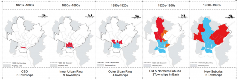
In 1876, the area of Yangon expanded from its original 2 sq-km to 29 sq-km [28, 29]. As the population grew in 1890, the British administration extended the city to the north, incorporating areas around Kandawgyi Lake and Inya Lake as affluent residential districts, now known as the Inner Urban Rings. The 1920s witnessed further expansion to the north, termed the Outer Urban Rings [30]. In 1921, a new urban planning committee enlarged Yangon's boundaries to encompass an extensive area of nearly 80 sq-km [29].
Following Burma's Independence in 1948, Yangon experienced a substantial influx of migration, resulting in overcrowding in the small central city area and the formation of squatter settlements around the city [21]. The urban area, at this point, measured 121.70 sq-km with a population of 0.74 million [31]. In the 1950s, the government established three new satellite towns, namely South Okkalapa, North Okkalapa, and Tharkayta, expanding the city area to 164.21 sq-km with a population of 0.94 million. This expansion continued, reaching 347.13 sq-km with a population of 2.513 million in 1983 [31].
Subsequently, the government established three new residential suburbs, known as old suburbs, namely Dagon, Hlaingtharyar, and Shwepyithar, followed by the development of six new industrial towns known as new suburbs in the late 1980s [30]. By 1993, urbanization covered 579.80 sq-km with a population of 3.10 million. According to the 2014 national census, Greater Yangon had expanded to 794.0 sq-km, accommodating 5.14 million residents, establishing Yangon as one of the Southeast Asian cities with the most extensive urban spatial extent [31].
The majority of the new urban expansion in Yangon has primarily occurred in the northward, northeast, and northwest directions, while there has been limited growth in the southern part of Yangon due to geographical challenges posed by the presence of rivers, water supply constraints, and transportation issues [17]. Presently, Yangon City is divided into seven zones: i) central business district (CBD); ii) inner urban ring (IUR); iii) Outer ring (OR); iv) south of the CBD (SCBD); v) older suburb (OSU); vi) northern suburb (NSU), and vii) new suburb (NS), encompassing a total of 33 townships. Although there is a plan to expand the boundaries of the metropolitan region in Yangon, this plan has not been implemented yet, and the metropolitan area of Yangon remains unchanged since 1995 (Figures 1 and 2).
Figure 1. The growth of Yangon from 1880s to 1995
Source: Authors based on YCDC data
Figure 2. Structural hierarchy of administrative region
Source: Authors based on YCDC data
2.3 Urban governance of Yangon
Myanmar's administrative structure encompasses five levels, ranging from regions or states at the first level to villages at the fifth level. Districts serve as the second-order division, followed by townships and, at the fourth level, either wards in urban areas or village tracts in rural regions. The provision of local governance services primarily occurs at the township level, where the township administrator acts as the main liaison with the government [25]. Wards function as the fourth and lowest administrative level in urban areas, while village tracts serve as the lowest level in rural regions.
Myanmar's primary administrative divisions are broadly classified as States and Regions, comprising seven states and seven regions. The administrative framework of the Yangon Region stands apart from that of other states and Union regions. Since the colonial era, the Yangon City Development Committee (YCDC) has held distinctive regional administrative features. Yangon region comprises 45 townships, covering a total area of 10,170 sq-km. Among these, 33 townships are situated within the administrative boundaries of Yangon City, which itself spans 794.49 sq-km, while the remaining 11 townships fall under the administration of the Yangon Regional Government [19, 32].
3.1 Materials
The Republic of the Union of Myanmar, usually referred to as Myanmar and previously known as Burma, is among the 11 sovereign states in Southeast Asia. It holds the 39th position globally in terms of land area and is the second-largest in Southeast Asia, according to the United Nations (UN) in 2013 [33].
The Yangon Metropolitan Area, also known as Greater Yangon, is situated in the Yangon Region, one of Myanmar's 15 current regions [20]. Yangon City serves as the capital of the region and was the former capital of the entire country. Greater Yangon is positioned geographically between approximately 17° 06′ and 16° 35′N latitude and 95° 58′ and 96° 24′E longitude, situated east of the Ayeyarwaddy River delta, historically recognized as "the rice bowl of Asia" [20, 34]. Yangon City is located 34 km upstream from the mouth of the Yangon River, within the Gulf of Martaban of the Andaman Sea [30, 34].
Yangon City consists of 33 townships falling under the jurisdiction of the Yangon City Development Committee (YCDC). The urbanized zone originated around the Shwe Dagon Pagoda and along the Yangon River, which continue to serve as the heart of Yangon, specifically the Central Business District (CBD) [35]. Presently, an approximate radius of 15-20 km from the CBD has undergone urbanization, with exceptions in the southern and western directions. Expansion along major roads has surpassed a 20 km radius, particularly along key routes such as No.4, No.1, and No.3 Main Roads [21].
3.2 Methods
This study adopted an evolutionary approach (origin-pattern-function) of landscape progression as the fundamental framework (Figure 3) to conduct a systematic study on the evolution of public space and landscape change in Yangon. Other studies [6, 36-39] were used to construct the framework in question. Further literature on the framework can be found Feng’s [40].
This study employs a descriptive research and review methodology. Ndagi [41] asserts that descriptive research involves collecting data to examine and explain current practices, existing conditions, attitudes, reasons, and ongoing processes. However, the primary goal of descriptive research is not solely to explain what exists but to provide clarity on the discovered information [42-45]. The review process entails re-evaluating past studies related to the spatial transformation of Yangon City, with a specific focus on understanding the key enablers to the public spaces transformation. To validate the theoretical frame, a field observation was conducted along the content analysis. This approach aims to enhance both past and future research in this area.
Figure 3. Research framework espouses origin-pattern-function of landscape progression
Source: Authors adapted [5]
4.1 Key enablers for urban transformation
4.1.1 Population composition of Yangon
The largest city in Myanmar, Yangon, boasts a population of 5.2 million, constituting 14% of the national population, as reported in the Census Report of Yangon Region in 2014. Yangon has undergone significant growth, progressing from fewer than 2.5 million residents in 1983, according to the 1983 Census, to its 2014 population of 5.2 million [46]. The Yangon region encompasses 45 townships, including one-sub townships, with 33 of them falling within the jurisdiction of the Yangon City Development Committee (YCDC), signifying the metropolitan area of Yangon [25]. Despite the metropolitan area covering 10 percent of the land, 70 percent of residents dwell within the YCDC area (metropolitan area), while the remaining 30 percent reside in rural areas. The migration of people from other States/Regions to Yangon City in pursuit of employment, education, and various economic and social opportunities contributes significantly to the high population density of Yangon.
Analyzing Yangon Region's population pyramid reveals a narrow base and a bulge in the working-age group. The over representation of working-age adults in the city can be attributed to migration from neighboring states and regions, while declining birthrates contribute to the narrow base. This youth bulge indicates a substantial economically engaged population. According to the Myanmar Census 2014 report for Yangon, the total population is categorized into three primary groups: schooling age, working age, and dependent age. The dependency ratio for Yangon Region is reported as 41.1% [46] (Figure 4).
Figure 4. Age group distribution of Yangon
Source: Authors data based on 2014 census report
The average population density in Yangon is 3,259 per square kilometer, while the maximum density is 59,429 per square kilometer. Yangon's CBD is the most populated, and the city expands north along the Yangon and Hlaing River. Rapid growth over the past three decades has pushed the city's geographic center north. CBD has a high population density and resident population, while Hlaingtharya, Shwepyithar, and North Okkalapa Townships continue to attract rural-to-urban migrants [32].
4.1.2 Economic and employment situation of Yangon
Yangon, often referred to as "the Economic Center of Myanmar," constitutes 14% of the national population and contributes to 22% of the country's GDP, as indicated in the Census Report of Yangon Region in 2014. The residents of Yangon enjoy a higher standard of living compared to other regions, and the influx of people seeking economic opportunities has led to rapid population growth, as highlighted in the LSE report of 2017. Managing this population influx, addressing the associated demands on infrastructure and services, and translating it into increased productivity and a higher quality of life for urban residents are pivotal challenges for Yangon [32].
The Census Report of Yangon Region in 2014 disclosed that over 3.3 million individuals aged ten and above were employed in the Yangon region, with agriculture, manufacturing, and retail trade being the three predominant job sectors. Currently, 2.4 million people in Yangon are employed in the formal economy. While estimates suggest that as much as 61% of the population is employed in the service industry, these jobs are predominantly unskilled and non-tradable, such as food preparation and transportation of goods and people [46].
Myanmar's economic situation saw improvement since 2012, marked by the adoption of a democratic system and the opening of its international market. However, since 2021, under a military dictatorship and limited economic growth due to political instability, Myanmar has experienced one of the most severe economic contractions globally. The country has faced economic decline, rising inflation, and the impacts of the global pandemic, primarily driven by the political instability prevailing in the country.
4.1.3 Environmental condition of Yangon
Yangon is positioned to the east of the Ayeyarwady River delta, along the Yangon River, within the latitude range of 17°06' to 16°35' N and the longitude range of 95°58' to 96°24' E. Located 34 kilometers upstream from the mouth of the Yangon River, the city features low hills, forming a lengthy and narrow spur of the Pegu-Yoma hill range in the central area, running in a north-south direction with an average height of 30 meters. These hills gradually transition into delta lowlands to the east and west. Yangon is bordered to the south, southeast, and southwest by the Yangon, Hlaing, and Bago rivers. The Nga Moe Yeik Creek traverses the middle of Yangon before transforming into Pazundaung Creek and flowing into the Bago River. The Yangon River is the largest water body, covering 27.80% of the total water body surface area. In Thanlyin Township, the Bago River is the second largest water body, constituting 13.82% of the total area. Both water bodies exhibit salinity [31].
Between December and February, there is a notable variation of over 20 degrees Celsius between the monthly maximum and minimum temperatures, and during the peak monsoon season from June to August, the variation ranges between 10 and 15 degrees Celsius. Yangon experiences severe and short-duration rainfall, contributing to urban flooding issues [47].
Myanmar is recognized as a biodiversity hotspot, and within Metropolitan Yangon, there are three endangered animal species and two vulnerable plant species. These endangered species are safeguarded under Myanmar's Forest Law. Hlawga Park in Yangon is designated as a watershed protection forest, part of Myanmar's forty protected areas, which include animal and bird sanctuaries, national parks, and nature reserves [48].
4.2 State of the art-Yangon land-use
4.2.1 Urban growth of Yangon and its land use
The extent of developed land in Yangon has expanded significantly, more than tripling from 62.69 sq-km in 1989 to 228.89 sq-km in 2014 over the past 25 years [20]. A comparative analysis of land use by JICA between 2002 and 2012 revealed a 20% increase in built-up area during that period [21]. Additionally, a study by [17] indicated substantial growth in Yangon's urban built-up land from 1990 to 2000, a pause until 2010, and rapid expansion between 2010 and 2020. The urban built-up area expanded from 161 sq-km in 1990 to 289 sq-km in 2000, 329 sq-km in 2010, and 739 sq-km in 2020. In the two decades of 1990-2000 and 2010-2020, significant proportions of agricultural and green land, 44% and 328 sq-km, respectively, were converted into urban built-up land. This transformation highlights the predominant conversion of land from agriculture and green spaces [17].
Similarly, the JICA study [21] noted that a majority of the increased built-up area was initially categorized as "Under Developing Area" and "Agricultural Area," including cultivated land, plantations, and cattle farms. However, during the same period, the "Under Developing Area" declined, indicating that urbanization outpaced the preparation and extension of under-developed areas, leading to the development of agricultural land and open spaces and a consequent reduction in Yangon's open spaces.
While previous studies [43, 49, 50] emphasized the insignificance of industrial emissions compared to automobile emissions in the urban atmosphere, Fan et al. [17] identified a key source of atmospheric pollution in Yangon. Despite not yet being an industrialized hub, the study suggests that the strong correlation between economic development and atmospheric pollutants may not be immediately apparent in the early phases of industrialization.
4.2.2 Yangon land use pattern
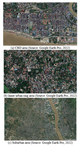
The Central Business District (CBD) area of Yangon is established on the initial grid-pattern urban layout constructed by the British during the colonial period. It features medium-height buildings serving both commercial and residential purposes, with governmental offices predominantly situated in this district. The CBD area experiences high population density, resulting in minimal available vacant land. According to JICA [48], Maha Bandula Park stands as the sole green space within the CBD. Plans for urban development in 2017 include the revitalization of residential alleyways in the CBD to create additional public spaces (Figure 5).
Figure 5. Land use patterns of Yangon
The Inner Urban Ring of Yangon is densely populated with medium-height residential and commercial structures, and there appears to be better maintenance of roads and green spaces compared to the CBD area. The inner area, situated around the circular railway and private golf courses, has restricted access for the general public. Additionally, large-scale development zones, including airports, depots, factories, and exclusive public facilities, have limited land use availability for the residents of Yangon [51]. This region boasts naturally preserved green areas, parks, and ponds, contributing to the overall appeal of the Inner Urban Ring in Yangon.
Currently, the Suburbs of Yangon, known as the suburbs, are experiencing substantial urbanization with a notable increase in new housing developments to accommodate the expanding population. This entire region can be characterized as "mixed development," signifying that certain sections have been developed, while others remain in the process of being developed [21]. The suburbs attract a significant portion of immigrants, industrial workers, and low-income residents due to the relatively lower cost of living and affordable rental prices.
4.3 Yangon urban open spaces
4.3.1 Neighborhoods open spaces in Yangon
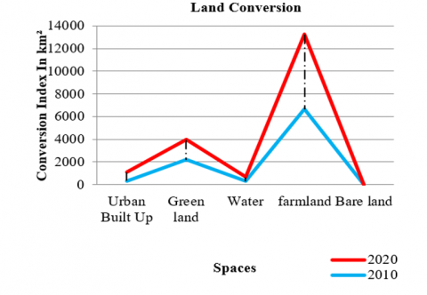
As of the 2020 open spaces conversion index, the predominant land use in Yangon is agricultural, covering 69.8% of the total area. This is followed by green land, constituting 18.6% of the total area, with urbanized built-up areas accounting for 7.8%, and water making up 3.8%. Over a decade, there has been an observable increase in urbanization within the Yangon metropolitan area. Concurrent with the rising population growth, there is a gradual decrease in agricultural land and open spaces. The estimated proportion of community space conversion for the entire Yangon Metropolitan area is approximately 4%, indicating a significant depletion of public open spaces for the residents of Yangon [17].
Laws and regulations pertaining to public parks and green areas are not well-established in Myanmar. To address this, YCDC implemented the "Parks and Recreation By-law (Order No.8/99)" in 1999, defining and managing public parks and playgrounds. Public open spaces are categorized based on legal standards: (i) For public park, an enclosed space established in accordance with urban characteristics, equipped with trees, fruits, flowers, rest houses, and playgrounds for citizen recreation; (ii) Scenic spot require an area created for public recreation and to enhance the city's scenic beauty; (iii) Nursery shold be designated space for cultivating and storing trees, flowering plants, and grass intended for planting in public parks and other relevant areas; (iv) Roundabout are enclosed space at the centre of a junction or road corners; (v) Playground is designated area for public sports use and/or children's activities.
Yangon City currently has 58 public parks covering a total land area of 188 hectares, translating to 0.37 square meters per person, according to JICA [48]. This ratio falls below the standard green space ratio recommended in city planning. Additionally, nine townships in Yangon lack any public park or green space. While some lakes in central Yangon's low hills have been well-maintained as public parks or protected areas, the riverfront area faces challenges in effective public utilization due to barriers such as fences, port facilities, and other factors [21]. Yangon's green and public open space ratio is comparatively low compared to other Asian cities. According to the World Health Organization [52] standard, a city should have a minimum of 9 square meters of green space per person, whereas Yangon currently provides only 0.37 square meters per person (Figure 6 and Table 1).
Table 1. Observed urban open spaces (2010-2020 land conversion) for Yangon in km2
|
Land Use |
2020 Converted Land-Use (km2) |
Percent% |
2010 Converted Land-Use (km2) |
Percent% |
|
Urban Built Up |
739 |
7.8 |
329 |
3.5 |
|
Green Land |
1745 |
18.6 |
2198 |
23.3 |
|
Water |
363 |
3.8 |
281 |
3.0 |
|
Farmland |
6592 |
69.8 |
6640 |
70.2 |
|
Bare Land |
0.0 |
0.0 |
1 |
0.0 |
|
Total |
9449 |
100% |
9449 |
100% |
Source: [17]
Figure 6. Land conversion index of Yangon region, 2010-2020
Source: Authors
4.3.2 Public open space declining issue in Yangon
Since the democratization of the country in 2012, Yangon has undergone rapid urbanization and grappled with significant challenges such as traffic congestion and inadequate housing. While the government is actively addressing these issues, essential amenities like sufficient public space for the people remain unattainable [16]. Despite Yangon's historical reputation as the "garden of the East" during the colonial era, the socialist period neglected the incorporation of green spaces in urban planning [17].
According to the JICA [48] report on the Strategic Urban Development Plan of Greater Yangon, green spaces in Yangon, including public parks, pagodas, and other public areas, cover a total area of 1272 hectares, equivalent to 2.3 square meters per person [21]. However, YCDC's (Yangon City Development Committee) official statement in 2016 indicates that the overall area of Yangon's parks, totalling 211.25 hectares, accounts for 1.74 square meters of green space per person [22]. Despite YCDC's encouragement for the improvement of green space to support environmental sustainability, real estate development fuelled by population growth and rapid urbanization has encroached upon these areas. Over 25 years, Yangon has experienced a 40% reduction in public and green spaces. Although the city provided around 3 square meters of green space per resident in 1990, this area dwindled to 0.41 square meters in 2014 [23]. Fan et al. [17] underscore that the scarcity of green space is a major environmental challenge in Yangon, and the provision of public open space remains a contentious issue (Figure 7).
Figure 7. Land use of Yangon region, 2020
Source: Reprint by authors data based on YCDC
Based on recent studies and data on green spaces in Yangon, the available green space per person has steadily decreased from 2.3 square meters in 2013 to 1.74 square meters in 2016, reaching a concerning low of 0.41 square meters per person in 2019. This alarming trend poses potential impacts on Yangon's social life and may hinder the city's prospects for sustainability.
Furthermore, the privatization of public open spaces through real estate projects and commercial development over the past two decades stands out as a significant factor contributing to the decline of public open spaces in Yangon [17]. Notably, the establishment of a supermarket resulted in the disappearance of 10 acres of "Kanthaya Park" in North Okkalapa townships. Additionally, in 2013, 44.5 acres of "Mya Kyun Thar Park" were designated for commercial and building projects related to an amusement park, but as of 2019, the master plan has yet to be implemented [23]. The rapid tripling of Yangon's built-up land since 1989, influenced by population growth and urban land changes, poses sustainability challenges for urban development in Yangon. Thus, safeguarding and preserving urban green spaces, forests, and agricultural lands become imperative for sustainable urbanization and ensuring a comfortable city life [20].
Yangon has undergone swift development, witnessing an increase in population and grappling with land scarcity issues. As much of Yangon's land has already been allocated for real estate development, finding new land for public space to meet the needs of urban residents has become a daunting task. The population of Yangon has doubled, reaching 5.2 million in 2014 from 2.9 million in 1990, and is projected to hit 7 million in 2024 and 10.79 million by 2040 [23, 48]. The importance of public spaces in urban environments is crucial due to the rising demand for areas that facilitate social interaction and provide essential infrastructure for community living. With an increasing population density and built-up area, the lack of new public community spaces in the future may result in the loss of community spaces for Yangon residents. Therefore, without proactive efforts to develop public spaces in the city, the scarcity of public space is likely to intensify in the future [53].
Yangon currently lacks proper criteria or standards for creating new public open spaces and parks, exacerbating the challenge of green space availability with the expected growth in population. Furthermore, the costs associated with private sector-led urban development projects pose additional constraints [21]. Consequently, exploring the feasibility of creating public spaces on linear urban infrastructure emerges as a novel approach for public space development in Yangon.
Based on archaeological findings, Yangon City can be dated back to a few centuries B.C. This is associated with King Alaungpaya, who established the town known as the pre-urban Dagon villages along a quiet riverside, now transformed into a bustling neighborhood. Yangon expanded its urban built-up land rapidly for over two decades. Over the years, it is evident that the land use transformed from urban green spaces to urban infrastructures. During this period, the majority of new urban land expanded into the northeast/northwest, whereas little change was observed to the south of the Yangon River. Finally, it worth noting that the military governance, globalization, Cyclone Nargis are among the key drivers but fall within the context of this study limitations.
This section sum-up findings based on Yangon’s planning evolution, Key Enablers for Yangon Urban Transformation as well land-use pattern and open space challenges. Yangon, historically known as Rangoon and initially developed by King Alaungpaya, has undergone significant transformations driven by its population dynamics, socio-economic conditions, and environmental factors. Its landscape evolution reflects the city's adaptation to various pressures and opportunities over time.
It came to notice that Yangon's population experienced significant growth from 1983 to 2014, primarily residing in the metropolitan area (YCDC), which represents 14% of Myanmar's national population. This growth is mainly attributed to migration for employment and education, has resulted in a dense, narrow-based demographic pyramid with a notable bulge in the working-age group due to migration and declining birth rates. This results in a dependency ratio of 41.1%, indicating a large portion of economically active individuals.
The study reveals that Yangon contributing 22% of Myanmar's GDP, with a diversified industrial structure encompassing industry, commerce, and services. However, since 2021, political instability and the global pandemic have led to economic decline, rising inflation, and severe contractions. The city is also a biodiversity hot spot with several endangered species protected under Myanmar's Forest Law. Despite the presence of green spaces and public parks, rapid urbanization, traffic congestion, and inadequate housing are pressing issues, with urban development often encroaching on these areas.
The study reveals Yangon’s landscape transformation, showing that the developed land area has more than tripled from 62.69 sq km in 1989 to 228.89 sq km in 2014. This expansion, driven by government policies, private sector development, migration due to Cyclone Nargis, and economic growth, has led to significant conversion of agricultural and green lands into urban built-up areas, especially between 1990-2000 and 2010-2020. The Central Business District (CBD) is characterized by medium-height commercial and residential buildings with minimal vacant land and limited green space. The Inner Urban Ring is densely populated with better-maintained roads and green spaces, though large-scale developments limit available land. The suburbs are seeing significant urbanization, attracting immigrants and low-income residents due to more affordable living costs.
Moreover, it highlights the urban open spaces of Yangon, which have 58 public parks covering 188 hectares, providing only 0.37 square meters per person, below city planning standards and significantly lower of the World Health Organization's recommended green space ratio. The privatization of open spaces due to real estate development has led to a notable decline in public and green spaces, posing challenges for sustaining community areas. However, the historical landscapes coexist with modern developments, reflecting Yangon's continuous evolution over centuries.
Yangon's urban development varies across its four districts, with differing population growth rates. Future urban land transformation is expected to continue with sprawl and infill expansion patterns. Rapid landscape changes and population increases pose significant challenges to urban regeneration and landscape planning. To achieve sustainable urbanization and a comfortable urban life in the Yangon Metropolitan Area, it's crucial to actively protect and conserve public open spaces and the natural environment, especially urban green spaces.
Addressing issues such as unhealthy urban development, poor use of public open spaces, and the conversion of green spaces requires collaboration among government, local communities, property owners, professional planners, architects, and environmental experts. Proper criteria and standards must be followed to create new public open spaces and parks to meet these challenges effectively.
Here are the key criteria for creating public open spaces:
While the Recommended standards for creating public open spaces and parks are: (a) World Health Organization (WHO) recommends a minimum of 9 square meters of green space per capita; (b) European Environment Agency (EEA) suggests that urban residents should have access to at least 0.5 hectares of green space within 300 meters of their home; (c) United Nations Sustainable Development Goals (SDGs) emphasize the importance of providing universal access to safe, inclusive, and accessible urban open spaces (SDG 11.7).
To address the challenge of urban landscape espouses public space in Yangon the following implementation measures should be considered:
Future research to support Yangon's urban transformation should focus on several key areas. Longitudinal studies on migration patterns are essential to understanding impacts on demographics, economic growth, and urban development, aiding in infrastructure and service planning. Examining the impact of political stability on urban development can provide insights into mitigating negative effects during political unrest. Exploring sustainable urban planning models that incorporate green building practices, and sustainable transportation is crucial, with comparative studies offering practical solutions. Detailed studies on the ecosystem services of urban green spaces can highlight their role in biodiversity, climate regulation, and public health, emphasizing the need for preservation. Analyzing public perception and usage of parks can inform more inclusive and effective designs. Economic valuation of green spaces can justify investments by showcasing their benefits on property values, tourism, and local economies. Studying the resilience of urban infrastructure and green spaces to climate change impacts can guide adaptive strategies for urban resilience. Finally, evaluating community engagement methods in urban planning can help develop best practices for creating user-friendly public spaces. Focusing on these areas can provide valuable insights and practical solutions for Yangon's sustainable, inclusive, and resilient urban transformation.
[1] Bosselmann, P. (2011). Metropolitan landscape morphology. Built Environment, 37(4): 462-478.
[2] Jim, C.Y., Chen, S.S. (2003). Comprehensive greenspace planning based on landscape ecology principles in compact Nanjing city, China. Landscape and Urban Planning, 65(3): 95-116. https://doi.org/10.1016/S0169-2046(02)00244-X
[3] Yu, K. (2011). Ecological infrastructure leads the way: The negative approach and landscape urbanism for smart preservation and smart growth. Applied Urban Ecology: A Global Framework, pp. 152-169. https://doi.org/10.1002/9781444345025.ch12
[4] Moughtin, C. (1996) Urban Design: Green Dimensions (1st ed).
[5] Yusuf, D.A., Zhu, J., Nashe, S.A., Usman, A.M., Sagir, A., Yukubu, A., Hamma, A.S., Alfa, N.S., Ahmed, A. (2023). A typology for urban landscape progression: Toward a sustainable planning mechanism in Kano Metropolis, Nigeria. Urban Science, 7(2): 36. https://doi.org/10.3390/urbansci7020036
[6] Yusuf, D.A., Zhu, J., Saleh-Bala, M., Yakubu, A., Nashe, A.S. (2023). Evolutionary trends in the landscape of Hausa open spaces: Key enablers of habe city planning mythology. Journal of Regional and City Planning, 34(2): 204-217. https://doi.org/10.5614/jpwk.2023.34.2.4
[7] Howard, E. (1965). Garden Cites of Tomorrow. London: Faber and Faber.
[8] Umar, G.K., Yusuf, D.A., Mustapha, A. (2019). Urban land use, planning and historical theories: An overview of Kano Metropolis. World Scientific News, 118: 257-264.
[9] Umar, G.K., Yusuf, D.A. (2019). Socio-cultural rejuvenation: A quest for architectural contribution in Kano cultural centres, Nigeria. International Journal of Advanced Academic Research | Social and Management Sciences, 5(3): 46-56.
[10] Kabir, G.U. (2008). Transformation in Hausa traditional architecture: A case study of some selected parts of Kano Metropolis (1950-2004). Ahmadu Bello University: Zaria, Nigeria.
[11] Yusuf, D.A., Ahmed, A., Zhu, J., Usman, A.M., Gajale, M.S., Zhang, S., Jiang, J., Hussian, J.U., Zakari, A.T., Yusuf, A.A. (2023). Quest for an innovative methodology for retrofitting urban built heritage: An assessment of some historic buildings in Kano Metropolis, Nigeria. Buildings, 13(8): 1899. https://doi.org/10.3390/buildings13081899
[12] Cui, L., Shi, J. (2012). Urbanization and its environmental effects in Shanghai, China. Urban Climate, 2: 1-15. https://doi.org/10.1016/j.uclim.2012.10.008
[13] DESA/United Nations. (2011). Population distribution, urbanization, internal migration and development: An international perspective. https://www.un.org/development/desa/pd/content/population-distribution-urbanization-internal-migration-and-development-international.
[14] Zhao, L.H. (2016). Spatial and temporal change of landscape pattern in Nanchang and its driving force. Jiangxi Agricultural University. http://cdmd.cnki.com.cn/Article/CDMD-10410-1016278250.htm.
[15] Seto, K.C., Fragkias, M., Güneralp, B., Reilly, M.K. (2011). A meta-analysis of global urban land expansion. PloS One, 6(8): e23777. http://doi.org/10.1371/journal.pone.0023777
[16] Matsushita, T. (2018). Impact evaluation of alley revitalization project in Yangon and investigation of potential as urban commons. Great Asian Streets, National University of Singapore.
[17] Fan, P., Chen, J., Fung, C., Naing, Z., Ouyang, Z., Nyunt, K.M., Myint, Z.N., Qi, J., Messina, J.P., Myint, S.W., Peter, B.G. (2022). Urbanization, economic development, and environmental changes in transitional economies in the global south: A case of Yangon. Ecological Processes, 11(1): 65. https://doi.org/10.1186/s13717-022-00409-6
[18] Gómez-Ibáñez, J.A., Bok, D., Kennedy, J.F., Thành, N.X. (2012). Yangon’s development challenges. Yangon, Myanmar. https://ash.harvard.edu/wp-content/uploads/2024/02/yangon.pdf.
[19] GAD. (2020) Regional information, Yangon region. Yangon, Myanmar. https://themimu.info/mimu-township-profiles-dashboard.
[20] Estoque, R.C. (2017). Yangon Metropolitan Area. Urban Development in Asia and Africa: Geospatial Analysis of Metropolises, pp. 171-193. https://doi.org/10.1007/978-981-10-3241-7_9
[21] JICA. (2013). The Project for the Strategic Urban Development Plan of the Greater Yangon Final Report I.
[22] YCDC. (2022). Yangon Urban Development Activities.
[23] Chann, Y. (2019). Green spaces in Yangon City: Towards a greener city for all. TeaCircle Oxford.
[24] Idris, H.A. (2022). Declining urban greenery in kano metropolis, Nigeria. Afrigist Journal of Land Administration and Environmental Management, 2(1): 1-13. https://doi.org/10.54222/afrigist/ajlaem/v2i1.1
[25] UNDP. (2014). The State of Local Governance: Trends in Yangon (Local Governance Mapping).
[26] Tha, K.P. (2018). Architects, Experts Slam Draft Law for Yangon City Development, The Irrawaddy, Yangon, Myanmar. https://www.irrawaddy.com/news/architects-experts-slam-draft-law-yangon-city-development.html.
[27] Sabrié, M. (2019). Yangon “Emerging Metropolis”: Challenges for the authorities and resilience of the Yangonites. Moussons. Recherche en sciences humaines sur l’Asie du Sud-Est, 33: 33-64. https://doi.org/10.4000/moussons.4892
[28] Myint, Z.N. (2006). Environmenta l Problems of Yangon City: Establishment of Industrial Zones. Doctoral Dissertation, MERAL Portal, pp. 217-236.
[29] Nwe, T.T. (1998). Yangon: The emergence of a new spatial order in Myanmar's capital city. Sojourn: Journal of Social Issues in Southeast Asia, 13(1): 86-113.
[30] Morley, I. (2013). Rangoon. Cities, 31: 601-614. https://doi.org/10.1016/j.cities.2012.08.005
[31] Thein, M. (2020). Impact of land-use for urbanization on Groundwater YANGON. In Groundwater Week 2020, pp. 1-10.
[32] LSEreport. (2017). Towards Urban Growth Analytics for Yangon. https://www.lse.ac.uk/cities/publications/research-reports/Towards-Urban-Growth-Analytics-for-Yangon.
[33] UN. (2015). World urbanization prospects: The 2014 revision. New York.
[34] Aung, Z.W., Dietrich, I.J., van der Heijden, I.S. (2014). Water supply options for the growing megacity of Yangon-scenarios with the WEAP model. Doctoral Dissertation, MSc Thesis, Leibniz University Hanover, Germany.
[35] Moe, S.S., Shwe, T. (2020). Study on trip generation rate and level of services of Myaynigone junction. GMSARN International Journal, 14(3): 142-146.
[36] Belmeziti, A., Cherqui, F., Kaufmann, B. (2018). Improving the multi-functionality of urban green spaces: Relations between components of green spaces and urban services. Sustainable Cities and Society, 43: 1-10. https://doi.org/10.1016/j.scs.2018.07.014
[37] Zhang, L., Wang, Z., Da, L. (2019). Spatial characteristics of urban green space: A case study of Shanghai, China. Applied Ecology & Environmental Research, 17(2): 1799-1815. http://doi.org/10.15666/aeer/1702_17991815
[38] Şenik, B., Uzun, O. (2022). A process approach to the open green space system planning. Landscape and Ecological Engineering, 18(2): 203-219. https://doi.org/10.1007/s11355-021-00492-5
[39] Umar, G.K., Yusuf, D.A., Ahmed, A., Usman, A.M. (2019). The practice of Hausa traditional architecture: Towards conservation and restoration of spatial morphology and techniques. Scientific African, 5: e00142. https://doi.org/10.1016/j.sciaf.2019.e00142
[40] Feng, Q. (2014). A typo-morphological enquiry into the evolution of urban and architectural forms in the Huangpu district of Shanghai, China. Doctoral Dissertation, Concordia University.
[41] Ndagi, J.O. (1999). The Essentials of Research Methodology for Educators. University Press.
[42] Ahmed, A., Muhammad, M. (2018). Rigour in quantitative research: Is there a Panacea to it? Malaysian Journal of Quantitative Research, 4(1): 60-68.
[43] Yusuf, D.A., Ahmed, A., Sagir, A., Yusuf, A.A., Yakubu, A., Zakari, A.T., Usman, A.M., Nashe, A.S., Hamma, A.S. (2023). A review of conceptual design and self health monitoring program in a vertical city: A case of Burj Khalifa, UAE. Buildings, 13(4): 1049. https://doi.org/10.3390/buildings13041049
[44] Aliyu, D.S., Abdu, Y.A., Yusuf, D.A. (2016). Transmission of ground vibration on road side structures. European Journal of Advances in Engineering and Technology, 3(7): 43-46.
[45] Vavilova, T., Bakhareva, Y. (2018). Architectural-typological innovations as a key factor for sustainable development of specially protected natural areas. In IOP Conference Series: Materials Science and Engineering, 463(3): 032081. https://doi.org/10.1088/1757-899X/463/3/032081
[46] Census Report of Yangon Region. (2014). The 2014 Myanmar Population and Housing Census, Yangon Region Census Report.
[47] MIP. (2014). Population and housing census of Myanmar, 2014: Provisional results. Census Report Volume 1. Yangon, Myanmar.
[48] JICAPart2. (2013). Part II, The Strategic Urban Development Plan of the Greater Yangon Yangon.
[49] Escobedo, F.J., Nowak, D.J. (2009). Spatial heterogeneity and air pollution removal by an urban forest. Landscape and Urban Planning, 90(3-4): 102-110.
[50] Hatami, M., Sotoudeh, A., Mokhtari, M.H., Kiani, B. (2022). Evaluation of the role of spatial composition and configuration of urban green spaces in air pollution reduction: A landscape ecology approach. Research Square, pp. 1-15. https://doi.org/10.21203/rs.3.rs-1586132/v1
[51] JICA-YCDC (Japan International Cooperation Agency and Yangon City Development Committee). (2013). A strategic urban development plan of Greater Yangon. Yangon, Myanmar. https://openjicareport.jica.go.jp/pdf/12122511.pdf.
[52] WHO. (2010). Urban Planning, Environment and Health from Evidence to Policy Action.
[53] Madanipour, A. (2019). Rethinking public space: Between rhetoric and reality. Urban Design International, 24: 38-46. https://doi.org/10.1057/s41289-019-00087-5