Muhammad Rizal H*![]() | Elly Warni
| Elly Warni![]() | Randy Angriawan
| Randy Angriawan![]() | Mochamad Hariadi
| Mochamad Hariadi![]() | Yunifa Miftachul Arif
| Yunifa Miftachul Arif![]() | Dina Maulina
| Dina Maulina![]()
© 2024 The authors. This article is published by IIETA and is licensed under the CC BY 4.0 license (http://creativecommons.org/licenses/by/4.0/).
OPEN ACCESS
Flooding is a natural disaster that has a serious impact on humans, the environment, and the economy. To reduce the risk and adverse impacts of flooding, this research aims to design an Internet of Things (IoT) based early detection system integrated with a decision support system. The proposed system uses various types of sensors, such as DHT22 to monitor air temperature and humidity, an Ombrometer to measure rainfall, a Water Flow Sensor to measure water flow, and an Ultrasonic Sensor to detect changes in water level. Data from these sensors will be collected in real time and analyzed to predict potential flooding. In addition, the system will have a user interface that facilitates monitoring and decision-making by authorities. The decision support system will use sensor data and weather information to warn decision-makers early of potential flooding and appropriate action recommendations. This research is expected to improve the ability to detect and respond to floods more effectively, thereby assisting in protecting human lives, protecting the environment, and reducing the economic impact of floods. In addition, this research contributes to the development of IoT-based technologies and decision support systems in the context of natural disaster mitigation.
flood, early warning system, Internet of Things (IoT), decision support system, TOPSIS
Based on data released by the National Disaster Management Agency (BNPB: Badan Nasional Penanggulangan Bencana), floods are a natural disaster that often hits Indonesia. The annual report from BNPB in 2021 highlighted that during the 2020 period, Indonesia experienced around 2,169 flood incidents in various regions. This figure shows a significant increase compared to 2019 data, which recorded only 1,015 flood events [1, 2]. The impact of this flood disaster is not only limited to physical damage but also affects the social and economic aspects of the community [3-7]. Damaged infrastructure, disruptions in people's daily routines, and the risk of losing lives are some consequences that often arise after floods [8, 9]. Given such a large impact, it is very important for the government and the community to jointly strive to overcome and prevent flood disasters so as not to cause more severe losses in the future [10, 11].
In recent years, the increasing frequency and severity of natural disasters, especially floods, have posed significant challenges for communities and governments worldwide. Floods, with devastating consequences on human life, infrastructure, and the environment, require proactive and efficient detection and management systems [12, 13]. Traditional flood monitoring and response mechanisms are often less effective in providing timely and accurate information, highlighting the need for innovative approaches. Conventional flood early detection systems often struggle with the timely and effective dissemination of warnings, primarily due to limited communication and community engagement. As highlighted by Perera et al. , these systems frequently fail to incorporate participatory approaches that involve local communities, leading to inadequate community response levels and poor translation of disaster risk reduction policies into actionable measures at the community level. Additionally, gaps in institutional communication and collaboration, as well as technical and financial constraints, often hinder the effectiveness of these systems [14]. Another significant limitation is the reach and speed of conventional systems, which are often not sufficient to alert the broader community in time to mitigate the impacts of impending disasters. As noted by Yuliandoko et al. [15], the use of IoT technology in flood detection can significantly enhance the speed and reach of warnings, allowing real-time data transmission and more effective community alerts. The convergence of the Internet of Things (IoT) and sophisticated decision support systems provides an unprecedented opportunity to revolutionize flood early detection and response [16, 17].
The Internet of Things, a transformative technological paradigm, has become instrumental in defining how we collect, process, and analyze data from multiple sources [18-23]. IoT's ability to connect sensors, devices, and data analysis tools in real-time can improve the monitoring of environmental parameters critical for flood prediction [20, 24-27]. In addition, integrating decision support systems can empower stakeholders with the insights needed to make timely and informed decisions, thereby reducing flood-related risks and damages [28]. The Internet of Things is a rapidly growing network of interconnected devices that can communicate with each other and exchange data. This technology has the potential to revolutionize many industries, including environmental monitoring [29]. By using IoT sensors to collect real-time data on various environmental factors, we can better comprehend the state of our environment and take steps to improve it. In this context, IoT can monitor air quality, water quality, waste management, smart agriculture, and remote monitoring [30-34].
This research addresses the critical need for flood early detection systems by leveraging the Internet of Things capabilities and robust decision support systems. By incorporating IoT sensors, data analytics, and user-friendly decision support system interfaces, the study aims to design comprehensive solutions that detect floods with precision and assist decision-makers in formulating effective strategies for flood response and mitigation.
Data analysis for decision making in this system is an important part of its development. With various parameters such as rainfall, water flow velocity, water level, temperature, and humidity. TOPSIS was used due to its flexibility in handling multi-criteria and efficient in the case of realtime data processing [35].
2.1 IoT in flood detection
Flood detection is an important aspect of disaster management, and the Internet of Things (IoT) can potentially improve flood detection systems [20, 21, 25, 28, 36]. IoT refers to the interconnection of physical devices, vehicles, buildings, and other objects embedded with electronics, software, sensors, and network connectivity, allowing these objects to collect and exchange data [37]. IoT integration in flood detection systems can provide real-time data and improve monitoring capabilities [21]. This literature review aims to explore the use of IoT in flood detection and provide insight into the current state of research on the topic. The following sections will discuss relevant studies that have explored the use of IoT in flood detection.
The research conducted proposed an IoT-based water monitoring system that measures water levels in real-time and reports water levels. The system uses machine learning algorithms to improve the accuracy of flood detection [20]. The study shows that the proposed system could be very efficient in detecting floods early and preventing loss of life and property. The study highlights the importance of real-time monitoring and machine learning algorithms in improving flood detection accuracy. The study also suggested that the proposed system could send notifications via SMS alerts whenever water levels and rainfall amounts cross threshold values. Overall, this study shows that IoT-based flood early detection systems using machine learning can effectively prevent loss of life and property due to flooding. In our research, we will develop decision support systems with actual data from sensors for smart solutions for disaster management in smart cities with integrated notification systems.
The research proposes a new architecture for building decision support systems using heterogeneous wireless sensor networks. Architectures built to monitor and predict floods use water level, water flow, ultrasonic, and magnetic field sensors [26, 38-40]. The study suggests that the proposed system could be very efficient in predicting floods early and preventing loss of life and property. The study highlights the importance of real-time monitoring and wireless sensor networks in improving flood prediction accuracy. The study also suggested that the proposed system could send notifications via SMS alerts whenever water levels and rainfall amounts cross threshold values. This research is a reference in the use of efficient heterogeneous wireless sensor networks and will be developed with decision support systems. The combination of good and efficient data collection will produce a better and actual system in accordance with real conditions in the field.
In addition, other studies have investigated the use of wireless sensor networks for real-time monitoring of river hydrological conditions for flood forecasting and early warning. This study describes the design and implementation of real-time flood monitoring systems (RTFMS) that perform flood forecasts based on available data to indicate possible flood behaviour [41]. The proposed system architecture for flood forecasting consists of sensors that sense and collect relevant data for calculations, compute nodes that have large processing power and apply the proposed distributed prediction algorithm, and a manned monitoring office that verifies results with available online information. Implement a centralized version of the prediction algorithm as a redundancy mechanism, issue alerts, and initiate evacuation plans. This system will increase the efficiency of the monitoring system and data processing of the developed system.
Our research integrates IoT sensors with the TOPSIS (Technique for Order of Preference by Similarity to Ideal Solution) method to classify flood status based on real-time sensor data. This is a key difference from previous studies, which generally only used machine learning algorithms or sensor networks without a specific decision-making methodology [42, 26]. We use different types of sensors, such as DHT22, Ombrometer, water flow sensors, and Ultrasonic Sensors, which comprehensively monitor environmental parameters affecting flooding. Previous studies have often been limited to one or two types of sensors, which may not provide a complete picture of the conditions leading to flooding [39]. The decision support system we developed not only relies on data from IoT sensors but also incorporates weather data to provide action recommendations to decision-makers. This improves the accuracy and speed of response to potential flooding, an innovation compared to previous systems that did not integrate external data [43]. This research was conducted by considering the local context in Indonesia, which often experiences floods. This provides high practical relevance and allows for better technology adaptation to specific field conditions. Previous studies have often been conducted in different contexts; thus, the results may not be entirely appropriate for Indonesia [15]. Our research seeks to improve communities’ ability to detect and respond to floods by integrating IoT and TOPSIS-based decision support systems. This innovation is expected to make a significant contribution to flood disaster mitigation and protect human life and the environment.
2.2 Decision support system for disaster management
In the research [44], developing knowledge management systems to support flood decision making aims to design and implement web-based knowledge management systems to support flood decision-making. This study highlights the importance of knowledge management systems (KMS) in supporting decision-making processes in disaster management. This study proposes a framework for developing KMS that includes identifying decision-makers knowledge needs, designing KMS architecture, and implementing KMS. This study shows that the proposed KMS can be very efficient in supporting the decision-making process in flood management. The search results show that knowledge management systems can support decision-making processes in flood management. The study highlights the importance of real-time monitoring, the use of wireless sensor networks, and the application of AHP analytical hierarchical processes in improving the accuracy of flood prediction and decision-making. The study also shows that the proposed system can send notifications via SMS alerts whenever water levels and rainfall amounts cross threshold values. These studies emphasize the importance of public perception and social context in building a shared framework to support the urban flood mitigation agenda.
The research [22] proposes a conceptual framework for an intelligent decision support system (IDSS) for smart city disaster management. This study highlights the importance of IDSS in supporting decision-making processes in disaster management. This study proposes a framework for developing IDSS that includes identifying the knowledge needs of decision-makers, designing the IDSS architecture, and implementing IDSS. This study shows that the proposed IDSS could efficiently support smart city disaster management decision-making processes. The proposed IDSS framework consists of four main components: data acquisition, data processing, decision-making, and feedback. The data acquisition component involves collecting data from various sources, including censorship, social media, and other relevant sources. The data processing component involves processing data collected using various techniques, including data mining, machine learning, and statistical analysis. The decision-making component involves using processed data to make informed decisions, including forecasting the occurrence of disasters and identifying the top course of action to mitigate the impact of disasters. The feedback component involves providing feedback to decision makers regarding the effectiveness of decisions made and the overall performance of the IDSS. This study shows that smart decision support systems can effectively support smart city disaster management decision-making processes. The proposed framework can help decision-makers to make informed decisions and mitigate disaster impacts [45].
Intelligent disaster decision support system (IDDSS) as a road, traffic, geographic, economic, and meteorological data integration framework [46]. Smart Decision Support Systems (IDDSS) are used to effectively manage the road network in the event of a flood. Law enforcement agencies are equipped with precise location information to mitigate potentially dangerous traffic situations and establish traffic management points (TMPs) in emergencies. Develop a conceptual framework for intelligent decision support systems (DSS) to facilitate reservoir operations in emergencies, such as those caused by high rainfall events. This model has the potential to assist reservoir operators in making appropriate assessments of reservoir water releases, thereby ensuring sufficient capacity for the water discharged and reducing local flood risk. In addition, the integration of artificial intelligence (AI) into decision support systems (DSS) has been implemented to improve the efficiency of the decision-making process. The Dijkstra algorithm is a computational method that determines the shortest route between two specific places [47]. This technique has been widely used in various domains and disciplines. The methods mentioned in this context have been commonly used in forest fire modeling and improving the effectiveness of route planning. Research [47] Improved the algorithm by including a Geographic Information System (GIS) to help firefighters identify the most efficient and safe entry routes. This system requires the use of many spatial datasets, including those relating to road networks and land resources. Barrier systems have been used to mimic the state of prohibited roads. Therefore, this system not only serves to ensure the most efficient route but also assists firefighters in recognizing unexpected situations and choosing safe and reliable paths.
3.1 IoT-Based flood detection system design
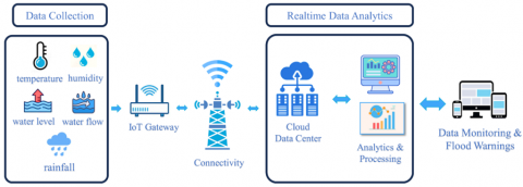
The flood detection system was designed as a main component consisting of four sensors that serve as a reference in decision-making related to flood status, as shown in Figure 1. Each sensor in the flood early detection system is connected to a microcontroller and connected to the internet via a Wi-Fi module to send real-time data to the Data Center. The received data are stored and aggregated for processing. Once collected, the data are analyzed using the TOPSIS method, with multi-criteria analysis to assess flood risk based on parameters from various sensors. The results of this analysis were integrated into a decision support system to provide recommendations and warnings to users. The decision support system then sends information regarding the flood status to user devices such as smartphones or computers, so that users can receive early warnings and take necessary actions in case of potential flooding.
The parameters in flood early detection are based on factors associated with flood risk, identified through historical data and previous studies in the target area and some related research [26, 38-40]. Temperature and humidity were chosen because changes in temperature indicate weather conditions that favor rainfall. Furthermore, rainfall is one of the main causes of flooding. The Water Flow Sensor is used to monitor the flow of water which is an indication of flooding. Another parameter is the water level which gives a direct indication of the possibility of flooding. By selecting these parameters, the flood early detection system can provide more accurate and timely warnings, enabling effective mitigation actions.
Figure 1. IoT Architecture design of flood detection systems
This system has been named the "Flood Detection". The sensors integrated in this system include:
(1) DHT22 sensors are used in this system to monitor the temperature and humidity of the air around potentially flooded areas. The use of DHT22 sensors allows the detection of significant changes in humidity and temperature that can provide an indication of adverse weather conditions, including heavy rains that can trigger flooding.
(2) Rainfall Sensor Ombrometer: Rainfall Sensor or Ombrometer is used in this system to measure and record changes in rainfall amount. The higher the rainfall detected by the Ombrometer, the higher the potential for flooding. In other words, these sensors help in monitoring rain intensity and warn about potential increased flood risk when rainfall increases significantly.
(3) A Water Flow Sensor is used in this system to measure the increase in water flow, which refers to the speed of water flow. The increased speed of water flow is an early indication of potential flooding that may occur. By monitoring changes in water flow, these sensors provide information that is important for understanding and detecting conditions that can cause flooding in an area.
(4) Ultrasonic sensors are used in these systems to detect changes in water levels, which could indicate that water levels have reached potential flooding levels. Using this sensor, we can keep a continuous eye on water levels and give warnings when water rises to a threshold that can cause flooding. These ultrasonic sensors play an important role in the early detection of potential floods and help in taking appropriate precautions.
3.2 Software and communication protocols
Flood detection systems that have been designed rely on hardware such as the sensors mentioned earlier and utilize software and communication protocols that are important in integrating and managing data from these sensors. Here are the software components and communication protocols used in this system:
(1) Monitoring Software: This system uses web-based software that manages data received from sensors. The software can process data in real time, perform analysis, and generate reports related to environmental conditions, including potential flood risks.
(2) Communication Protocols: The communication protocols used in these systems allow sensors to send data to monitoring devices efficiently. These protocols can be wireless network protocols such as Wi-Fi or Bluetooth or even special ones designed for environmental monitoring.
(3) Database: The data collected by these sensors is stored in a database that is available for access and analysis. This database allows the storage of historical data that is important for a long-term understanding of environmental conditions.
(4) Early Warning System: This system can also be equipped with an early warning system that will provide notifications or alarms to the authorities or the public when there is a high potential risk of flooding. This software will play an important role in managing early warnings and disseminating relevant information.
(5) User Interface: These systems can have a user interface that makes it easier for users, such as environmental monitoring officers or authorities, to access and understand the data that has been collected by sensors. This user interface can be a web-based app or an easy-to-use mobile app.
These software and communication protocols play an important role in performing the functions of flood detection systems, from sensor data collection to quick and precise decision-making in response to potentially hazardous environmental conditions. These entire systems work together to protect people and the environment from the risk of flooding that can occur.
3.3 Decision support system using the TOPSIS method
In this research, we have developed a decision support system based on the TOPSIS method to detect and classify flood status based on data captured by IoT sensors. These sensors successfully detect flood parameters such as rainfall, water level, water discharge, tides, temperature, and humidity. After the data is processed with the TOPSIS method, the system can classify it into four flood states: safe, alert, alert, and alert. From the results of the analysis, it was found that the water level and water discharge are the two parameters that have the highest weight in determining flood status. The steps for applying the TOPSIS method in flood classification are as follows:
(1) Defining Criteria and Alternatives: Determining the parameters or criteria to be used for flood classification, such as rainfall, water level, water discharge, tides, temperature, and humidity. In addition, it defines alternative flood statuses such as safe, alert, warning, and danger.
(2) Data Collection: Using IoT sensors to get real-time data from each predefined criterion. This data will then be processed to obtain relevant information.
(3) Decision Matrix Normalization: Converts raw data into a normalized decision matrix so that each data has a uniform scale.
$r_{i j}=\frac{x_{i j}}{\sqrt{\sum_{i=1}^m x^2{ }_{i j}}}$ (1)
(4) Determination of Criterion Weights: Determines the weights for each criterion based on their importance in the flood classification. This can be done in consultation with experts or analysis of historical data.
$y_{i j}=w_i r_{i j}$ (2)
(5) Calculating Ideal Positive and Ideal Negative Scores: Based on the normalized decision matrix and criteria weighting, calculate the positive ideal solution (best solution) and negative ideal solution (worst solution) for each criteria.
$A^{+}=\left(y_1{ }^{+}, y_2{ }^{+}, \ldots, y_n{ }^{+}\right)$ (3)
$A^{-}=\left(y_1{ }^{-}, y_2{ }^{-}, \ldots, y_n{ }^{-}\right)$ (4)
(6) Calculating the distance to the Ideal Solution: Calculates the distance between each alternative with a positive ideal solution and a negative ideal solution.
$D_1{ }^{+}=\sqrt{\sum_{j=1}^n\left(y_i{ }^{+}-y_{i j}\right)^2}$ (5)
$D_1^{-}=\sqrt{\sum_{j=1}^n\left(y_{i j-} y_i^{-}\right)^2}$ (6)
(7) Preference Score Calculation: Based on the distance to the ideal solution, calculate the preference score for each flood status alternative.
$V_i=\frac{D_i^{-}}{D_i^{-}+D_i{ }^{+}}$ (7)
(8) Ranking and Classification: Sorts alternatives based on the preference score obtained. The alternative with the highest preference score indicates the flood status that best suits the conditions at that time.
The data used as a basis for experiments in determining flood warning status through the TOPSIS method were obtained from the Pompengan Jeneberang River Center (BBWS: Balai Besar Wilayah Sungai) and an Indonesian government agency responsible for the Meteorology, Climatology, and Geophysics Agency (BMKG: Badan Meteorologi, Klimatologi, dan Geofisika). The two agencies have the main task of collecting and disseminating information on weather conditions and river situations, both of which are very relevant in determining flood alert status. Specific parameters that become a reference in determining this status are rainfall, water level, water discharge, tides, temperature, and humidity.
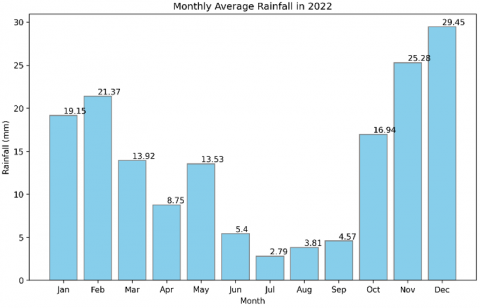
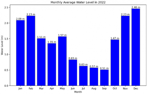
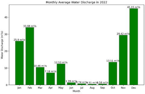
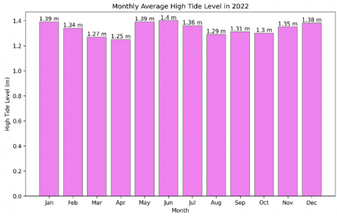
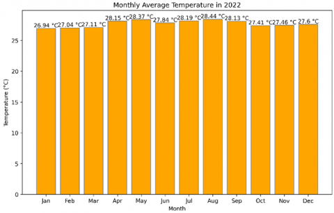
Figures 2-6 shows the climatic and hydrological conditions in the Makassar city area during 2022. The graph illustrates the monthly fluctuations of various environmental dimensions, including rainfall, water level, water discharge, tide, temperature, and humidity.
Table 1 shows the initial steps in applying the TOPSIS method to determine flood alert status. There are four alternatives described, namely: Safe, Alert, Warning, and Watchful. The evaluation is carried out based on six criteria, namely rainfall, water level, water discharge, tide, temperature, and humidity.
Table 2 presents the normalized matrix. This normalization process is important to ensure that each criterion has a balanced weight in the analysis, thus allowing us to compare and evaluate alternatives more objectively. With a normalized matrix, we can go further in the TOPSIS analysis to make more informed decisions.
Figure 2. Monthly average rainfall in 2022
Figure 3. Monthly average water level in 2022
Figure 4. Monthly average discharge level in 2022
Tabel 1. Defining criteria and alternatives
|
No |
Alternative |
Criteria 1 Rainfall (mm) |
Criteria 2 Water Level (m) |
Criteria 3 Water Discharge (m3/s) |
Criteria 4 Tides (cm) |
Criteria 5 Temperature (℃) |
Criteria 6 Humidity (%) |
|
1 |
Safe |
6 |
3 |
50.2 |
1.4 |
25.6 |
90 |
|
2 |
Alert |
10 |
1.23 |
13 |
1.4 |
28.7 |
84 |
|
3 |
Warning |
30 |
2.5 |
11.8 |
1.2 |
27 |
85 |
|
4 |
Watchful |
45 |
4.39 |
30.7 |
1.2 |
29 |
87 |
Figure 5. Monthly average high tide level in 2022
Figure 6. Monthly average water level in 2022
Tabel 2. Normalization matrix
|
No |
Alternative |
Criteria 1 Rainfall (mm) |
Criteria 2 Water Level (m) |
Criteria 3 Water Discharge (m3/s) |
Criteria 4 Tides (cm) |
Criteria 5 Temperature (℃) |
Criteria 6 Humidity (%) |
|
1 |
Safe |
0.1039 |
0.486 |
0.8074 |
0.4975 |
0.4296 |
0.4846 |
|
2 |
Alert |
0.2142 |
0.2347 |
0.2463 |
0.5859 |
0.5673 |
0.5327 |
|
3 |
Warning |
0.5828 |
0.4542 |
0.2129 |
0.4782 |
0.5082 |
0.5133 |
|
4 |
Watchful |
0.7769 |
0.7088 |
0.4921 |
0.425 |
0.4851 |
0.4669 |
Tabel 3. Weighted decision matrix
|
No |
Alternative |
Criteria 1 Rainfall (mm) |
Criteria 2 Water Level (m) |
Criteria 3 Water Discharge (m3/s) |
Criteria 4 Tides (cm) |
Criteria 5 Temperature (℃) |
Criteria 6 Humidity (%) |
|
1 |
Safe |
0.5197 |
2.43 |
4.0369 |
1.9898 |
1.2889 |
1.4537 |
|
2 |
Alert |
1.0711 |
1.1734 |
1.2313 |
2.3435 |
1.7019 |
1.598 |
|
3 |
Warning |
2.9142 |
2.2712 |
1.0643 |
1.9129 |
1.5247 |
1.5399 |
|
4 |
Watchful |
3.8846 |
3.544 |
2.4606 |
1.6999 |
1.4552 |
1.4006 |
Table 4. Positive ideal solution and negative ideal solution matrix
|
|
Criteria 1 |
Criteria 2 |
Criteria 3 |
Criteria 4 |
Criteria 5 |
Criteria 5 |
|
Solusi Ideal Positif A+ |
3.8846 |
3.5440 |
4.0369 |
2.3435 |
1.7019 |
1.5980 |
|
Solusi Ideal Negative A- |
0.5197 |
1.1734 |
1.0643 |
1.6999 |
1.2889 |
1.4006 |
Table 3 shows a matrix that has undergone weighting stages. Each entry in this matrix has been adjusted based on the specific weight of the corresponding criteria. This weighting process is carried out to ensure that each criterion has a comparable and appropriate influence on the overall analysis so that decisions made based on this matrix will be more objective and reflect the priorities that have been set.
Determination of the ideal solution matrix plays an important role. For a positive ideal solution matrix, the value taken is the maximum or highest value of each criterion in the weighted decision matrix. It reflects the optimal conditions of each criterion. In contrast, the matrix of negative ideal solutions is calculated based on the minimum or lowest value. Each criterion in the decision matrix is weighted, describing the worst-case scenario or least ideal conditions. All the results of these calculations are then neatly presented in Table 4 for easy interpretation and further analysis.
To assess the proximity of each alternative to ideal and worst-case conditions, we calculate the distance between alternatives with positive and negative solution matrices. This calculation process involves using the square root of the difference between the matrix of positive or negative solutions with matrices that have been normalized and weighted. The results of these distance calculations are then detailed in Table 5.
Table 6 shows a systematic representation of the preference value of V for each alternative that has been calculated through a specific procedure. Next, we will describe in detail the value of preference V associated with each alternative.
Using the TOPSIS method, the alternative with the highest preference value of V is the best alternative. Alternative 4 (Beware), with a preference value of 0.7152, is the most influential alternative in determining flood alert status.
Based on the experiment conducted for 12 full months, an illustration of the results can be seen in Figure 7. At the beginning of the year, specifically in January and February 2022, the flood alert status in the study area was categorized as watchful, according to data collected during the period. This indicates that in that two-month time frame, the potential for flooding in the area is significant enough to require intensive monitoring efforts.
Table 5. Alternative matrix of positive ideal solution and negative ideal solution
|
Alternative |
Positif A+ |
Negative A- |
|
Safe |
3.5889 |
3.2408 |
|
Alert |
4.6268 |
0.9776 |
|
Warning |
3.4086 |
2.6569 |
|
Watchful |
1.7318 |
4.3497 |
Table 6. Alternative reference value
|
Alternative |
Nilai Preferensi V |
Ranking |
|
Safe |
0.4745 |
2 |
|
Alert |
0.1744 |
4 |
|
Warning |
0.438 |
3 |
|
Watchful |
0.7152 |
1 |
Figure 7. Determining flood alert status
Data analysis in Figure 7 provides a vital source of information for decision-makers in flood risk management aspects. Given that January and February are identified as high-risk periods, anticipatory measures should be implemented immediately. This includes infrastructure preparation such as flood control facilities, closer monitoring of weather conditions, and educating the public to always be alert and obey evacuation directions when needed. Furthermore, the information in the graph also confirms how crucial weather condition monitoring activities and flood risk evaluations are carried out regularly. Through data collected throughout the year, we get a clear picture of the dynamics and patterns of flood risk in the region. This information is not only important for responsive action but also for long-term strategic planning, ensuring that every policy and action taken can provide maximum protection for communities from the threat of future floods.
The results presented in Table 7 illustrate the performance metrics of the tested model. The model achieved an accuracy of 0.83, indicating that it correctly predicts the outcome 83% of the time. Precision was perfect at 1.0, signifying that every instance predicted as positive was indeed positive. The recall rate of 0.92 demonstrates that the model successfully identified 92% of all actual positives. The F1 score, which is the harmonic mean of precision and recall, was notably high at 0.95, suggesting a balanced relationship between precision and recall in the model's performance.
Table 7. Result of accuracy (A), precision (P), recall (R), and F1 score (F1)
|
Accuracy (A) |
Precision (P) |
Recall (R) |
F1 score (F1) |
|
0.83 |
1 |
0.92 |
0.95 |
A key challenge in expanding these systems is the ability to handle large and increasing volumes of data from a wide range of IoT sensors. Each addition of sensors increases the load on the network and data storage infrastructure, requiring scalable and efficient technology solutions for real-time data processing. Although the use of IoT sensors can provide valuable data for flood prediction, the cost of procuring and maintaining these sensors can be a constraint, especially in areas with limited budgets. In addition, costs for network infrastructure and decision support systems also need to be considered to remain affordable and sustainable. These systems need to be tested in a variety of geographic and climatic environments to ensure reliability. Each site may have unique environmental characteristics, such as rainfall and water flow patterns, that require adjustments to sensor configurations and prediction algorithms. Further research could focus on applying and testing more sophisticated machine learning algorithms, such as deep learning, to improve flood prediction accuracy. The use of hybrid models that combine various machine learning techniques can also be explored to optimize prediction results. Future research could also be directed at developing more efficient and reliable communication protocols for data transfer between sensors and central systems. Protocols that are energy efficient and have low latency will be of great benefit to ensure quick response to changing conditions. Further studies can be conducted to evaluate the long-term costs and benefits of implementing this system.A comprehensive cost–benefit analysis will help in identifying areas where cost efficiency can be improved without sacrificing system quality and reliability. It is recommended to conduct field tests in various locations with different characteristics to evaluate the performance of the system in real time. The implementation of pilots in several areas will provide valuable insights into the adaptability and effectiveness of the system in real situations. Future research may also explore further integration with Geographic Information Systems (GIS) technologies for better visualization of flood data and more accurate risk modeling. This integration can help in more informed and effective decision making in flood risk management. By considering the challenges and limitations and directing future research to the mentioned areas, we are confident that this system can continue to evolve and make a significant contribution to flood mitigation.
This research results in a design for a flood early detection system based on Internet of Things (IoT) technology and a decision support system. By utilizing IoT devices, the system is able to collect real-time data from various sensors installed in strategic locations, such as rainfall sensors, water levels, and other parameters relevant to potential flooding. The collected data is then analyzed by the decision support system to determine the flood alert status, such as safe, alert, standby, and alert. The integration between IoT and the decision support system allows for more accurate, faster, and more efficient flood early detection. This certainly provides great benefits for interested parties, especially the community, government, and related agencies, in taking steps to prevent, mitigate, and respond to potential floods. The next aspect is the future challenge, Scalability in regional conditions and with larger areas. The addition of sensors will be another challenge for system adaptation to extreme conditions and erratic weather changes.
These metrics collectively indicate a robust model with strong predictive capabilities, especially in terms of precision and F1 score. The high precision implies that the model is highly reliable when it predicts a positive outcome. Meanwhile, the recall indicates that the model is also capable of capturing a significant proportion of actual positive cases, which is crucial for scenarios where failing to detect positives can have serious consequences.
The researchers would like to thank the Ministry of Research, Technology, and Higher Education of the Republic of Indonesia for funding this research under the Fundamental Research scheme in 2023 with Grand Number 201/SPK/D.D4/PPK.01.APTV/VI/2023.
[1] Andreas, H., Sarsito, D.A., Yuherdha, A.T., Pradipta, D. (2020). Urgent measure of geospatial parameters for flood modeling in Indonesia. International Journal on Advanced Science, Engineering and Information Technology, 10: 227-233. https://doi.org/10.18517/ijaseit.10.1.6743
[2] Wicaksono, A., Herdiansyah, H. (2019). The impact analysis of flood disaster in DKI jakarta: Prevention and control perspective. In Journal of Physics: Conference Series, 1339(1): 012092. https://doi.org/10.1088/1742-6596/1339/1/012092
[3] Loucks, D.P. (2015). Debates-Perspectives on socio-hydrology: Simulating hydrologic-human interactions. Water Resources Research, 51(6): 4789-4794. https://doi.org/10.1002/2015WR017002
[4] Aldardasawi, A.F.M., Eren, B. (2021). Floods and their impact on the environment. Academic Perspective Procedia, 4(2): 42-49. https://doi.org/10.33793/acperpro.04.02.24
[5] Jayswal, V., Gargi, A. (2023). To analysis the impact of flood on communities belong to various socio-economic background in the highly vulnerable regions along with the Yamuna Catchment Area, New Delhi. Knowledgeable Research: A Multidisciplinary Journal, 1(10): 1-22. https://doi.org/10.57067/kr.v1i10.79
[6] Allaire, M. (2018). Socio-economic impacts of flooding: A review of the empirical literature. Water Security, 3: 18-26. https://doi.org/10.1016/j.wasec.2018.09.002
[7] Oruonye, E.D. (2012). Socio-economic impact assessment of flash flood in Jalingo metropolis, Taraba State, Nigeria. International Journal of Environmental Sciences, 1(3): 135-140. https://api.semanticscholar.org/CorpusID:131051275
[8] Jongman, B., Winsemius, H.C., Fraser, S.A., Muis, S., Ward, P.J. (2018). Assessment and adaptation to climate change-related flood risks. In Oxford Research Encyclopedia of Natural Hazard Science. https://doi.org/10.1093/acrefore/9780199389407.013.278
[9] Jongman, B. (2018). Effective adaptation to rising flood risk. Nature Communications, 9(1): 1986. https://doi.org/10.1038/s41467-018-04396-1
[10] Dwirahmadi, F. (2015). Disaster risk reduction and climate change adaptation partnership through collaborative governance to build urban community resilience to flood risks in Jakarta. Griffith University. https://api.semanticscholar.org/CorpusID:169180522
[11] Noonan, D.S., Sadiq, A.A. (2019). Community-scale flood risk management: Effects of a voluntary national program on migration and development. Ecological Economics, 157: 92-99. https://doi.org/10.1016/j.ecolecon.2018.11.005
[12] Glago, F.J., Yao, K.G., Sedegah, R.E.A. (2019). Role of early warning systems in flood disaster preparedness: Insights from Asamankese in the West Akim Municipality of Ghana. Int. J. Innov. Res. Dev., 8(12): 256-263. https://doi.org/10.24940/ijird/2019/v8/i12/dec19064
[13] Löschner, L., Hartmann, T., Priest, S., Collentine, D. (2021). Strategic use of instruments of land policy for mobilising private land for flood risk management. Environmental Science and Policy, 118: 45-48. https://doi.org/10.1016/j.envsci.2021.01.009
[14] Perera, D., Agnihotri, J., Seidou, O., Djalante, R. (2020). Identifying societal challenges in flood early warning systems. International Journal of Disaster Risk Reduction, 51: 101794. https://doi.org/10.1016/j.ijdrr.2020.101794
[15] Yuliandoko, H., Subono, S., Wardhani, V. A., Pramono, S.H., Suwindarto, P. (2018). Design of flood warning system based IoT and water characteristics. TELKOMNIKA (Telecommunication Computing Electronics and Control), 16(5): 2101-2110. http://doi.org/10.12928/telkomnika.v16i5.7636
[16] Zhou, J., Shen, J., Herman, L., Du, Y. (2019). Study on multi-source data integrating standard and 3D cartographic visualization of urban flooding based on CityGML. Abstracts of the ICA, 1: 1-2. https://doi.org/10.5194/ica-abs-1-435-2019
[17] Helmholz, P., Zlatanova, S., Barton, J., Aleksandrov, M. (2020). Geoinformation for disaster management 2020 (GI4DM2020): PREFACE. ISPRS Annals of the Photogrammetry, Remote Sensing and Spatial Information Sciences, 6: 1-2. https://doi.org/10.5194/isprs-archives-XLIV-3-W1-2020-1-2020
[18] Nižetić, S., Šolić, P., Gonzalez-De, D.L.D.I., Patrono, L. (2020). Internet of Things (IoT): Opportunities, issues and challenges towards a smart and sustainable future. Journal of Cleaner Production, 274: 122877. https://doi.org/10.1016/j.jclepro.2020.122877
[19] Malche, T., Maheshwary, P., Kumar, R. (2019). Environmental monitoring system for smart city based on secure Internet of Things (IoT) architecture. Wireless Personal Communications, 107(4): 2143-2172. https://doi.org/10.1007/s11277-019-06376-0
[20] Mousavi, F.S., Yousefi, S., Abghari, H., Ghasemzadeh, A. (2021). Design of an IoT-based flood early detection system using machine learning. In 2021 26th International Computer Conference, Computer Society of Iran (CSICC), Tehran, Iran, pp. 1-7. https://doi.org/10.1109/CSICC52343.2021.9420594
[21] Basnyat, B., Singh, N., Roy, N., Gangopadhyay, A. (2020). Design and deployment of a flash flood monitoring IoT: Challenges and opportunities. In 2020 IEEE International Conference on Smart Computing (SMARTCOMP), Bologna, Italy, pp. 422-427. https://doi.org/10.1109/SMARTCOMP50058.2020.00088
[22] Jung, D., Tran Tuan, V., Quoc Tran, D., Park, M., Park, S. (2020). Conceptual framework of an intelligent decision support system for smart city disaster management. Applied Sciences, 10(2), 666. https://doi.org/10.3390/app10020666
[23] Kumar, N.S., Chandrasekaran, G., Rajamanickam, K.P. (2021). An integrated system for smart industrial monitoring system in the context of hazards based on the internet of things. International Journal of Safety and Security Engineering, 11(1): 123-127. https://doi.org/10.18280/ijsse.110114
[24] Jayashree, S., Sarika, S., Solai, A.L., Prathibha, S. (2017). A novel approach for early flood warning using android and IoT. In 2017 2nd International Conference on Computing and Communications Technologies (ICCCT), Chennai, India, pp. 339-343. https://doi.org/10.1109/ICCCT2.2017.7972302
[25] Hingmire, A.M., Bhaladhare, P.R. (2023). Building a smart city: A conceptual approach to real-time urban flood control system. In 2023 International Conference on Intelligent Data Communication Technologies and Internet of Things (IDCIoT), Bengaluru, India, pp. 759-764. https://doi.org/10.1109/IDCIoT56793.2023.10053509
[26] Yuliandoko, H., Subono, S., Wardhani, V. A., Pramono, S.H., Suwindarto, P. (2018). Design of flood warning system based IoT and water characteristics. TELKOMNIKA (Telecommunication Computing Electronics and Control), 16(5): 2101-2110. https://doi.org/10.12928/TELKOMNIKA.v16i5.7636
[27] Al Kindhi, B., Triana, M.I., Yuhana, U.L., Damarnegara, S., Istiqomah, F., Imaaduddiin, M.H. (2022). Flood identification with fuzzy logic based on rainfall and weather for smart city implementation. In 2022 IEEE International Conference on Communication, Networks and Satellite (COMNETSAT), Solo, Indonesia, pp. 67-72. https://doi.org/10.1109/COMNETSAT56033.2022.9994512
[28] Suwarno, I., Ma’arif, A., Raharja, N.M., Nurjanah, A., Ikhsan, J., Mutiarin, D. (2021). IoT-based lava flood early warning system with rainfall intensity monitoring and disaster communication technology. Emerging Science Journal, 4(0): 154-166. https://doi.org/10.28991/ESJ-2021-SP1-011
[29] Long, G. (2022). Design of indoor agaric cultivation monitoring device based on internet of things and emotional behavior change. International Journal of Neuropsychopharmacology, 25(Supplement_1): A32-A33. https://doi.org/10.1093/ijnp/pyac032.045
[30] Zeng, H., Dhiman, G., Sharma, A., Sharma, A., Tselykh, A. (2023). An IoT and Blockchain-based approach for the smart water management system in agriculture. Expert Systems, 40(4): e12892. https://doi.org/10.1111/exsy.12892
[31] Vishnu, S., Ramson, S.J., Senith, S., Anagnostopoulos, T., Abu-Mahfouz, A.M., Fan, X., Srinivasan, S., Kirubaraj, A.A. (2021). IoT-Enabled solid waste management in smart cities. Smart Cities, 4(3): 1004-1017. https://doi.org/10.3390/smartcities4030053
[32] Jan, F., Min-Allah, N., Düştegör, D. (2021). Iot based smart water quality monitoring: Recent techniques, trends and challenges for domestic applications. Water, 13(13): 1729. https://doi.org/10.3390/w13131729
[33] Ali, A. (2022). A framework for air pollution monitoring in smart cities by using IoT and smart sensors. Informatica, 46(5): 129-138. https://doi.org/10.31449/inf.v46i5.4003
[34] Wahul, R.M., Sonawane, S., Kale, A.P., Lambture, B. D., Dudhedia, M.A. (2023). Smart farm: Agriculture system for farmers using IoT. Ingenierie des Systemes d'Information, 28(2): 401-407. https://doi.org/10.18280/isi.280215
[35] Gupta, N., Sharma, V., Kashyap, M. (2018). A critical analysis of sensor based IoT architectures using fuzzy TOPSIS. In 2018 International Conference on Advances in Computing, Communication Control and Networking (ICACCCN), Greater Noida, India, pp. 21-27. https://doi.org/10.1109/ICACCCN.2018.8748382
[36] Satria, D., Yana, S., Munadi, R., Syahreza, S. (2020). Flood early warning information system for multilocation based android. International Journal of Engineering Technologies and Management Research, 5: 47-53. https://doi.org/10.29121/ijetmr.v5.i8.2018.279
[37] Hang, L., Khan, M.S., Kim, D.H. (2018). Design and implementation of IoT object virtualization for physical devices in smart home. International Journal of Control and Automation, 11(7): 1-10. https://doi.org/10.14257/ijca.2018.11.7.01
[38] Finley, P., Gatti, G., Goodall, J., Nelson, M., Nicholson, K., Shah, K. (2020). Flood monitoring and mitigation strategies for flood-prone urban areas. In 2020 Systems and Information Engineering Design Symposium (SIEDS), Charlottesville, VA, USA, pp. 1-6. https://doi.org/10.1109/SIEDS49339.2020.9106583
[39] Natividad, J.G., Mendez, J.M. (2018). Flood monitoring and early warning system using ultrasonic sensor. In IOP Conference Series: Materials Science and Engineering, 325(1): 012020. https://doi.org/10.1088/1757-899X/325/1/012020
[40] Shankar, B.M., John, T.J., Karthick, S., Pattanaik, B., Pattnaik, M., Karthikeyan, S. (2021). Internet of things based smart flood forecasting and early warning system. In 2021 5th International Conference on Computing Methodologies and Communication (ICCMC), Erode, India, pp. 443-447. https://doi.org/10.1109/ICCMC51019.2021.9418331
[41] Li, D., Huangfu, W., Long, K. (2017). Spline approximation-based data compression for sensor arrays in the wireless hydrologic monitoring system. International Journal of Distributed Sensor Networks, 13(2): 1550147717692584. https://doi.org/10.1177/1550147717692584
[42] Mousavi, S.K., Ghaffari, A., Besharat, S., Afshari, H. (2021). Improving the security of internet of things using cryptographic algorithms: A case of smart irrigation systems. Journal of Ambient Intelligence and Humanized Computing, 12(2): 2033-2051. https://doi.org/10.1007/s12652-020-02303-5
[43] Al Qundus, J., Dabbour, K., Gupta, S., Meissonier, R., Paschke, A. (2022). Wireless sensor network for AI-based flood disaster detection. Annals of Operations Research, 319: 697-719. https://doi.org/10.1007/s10479-020-03754-x
[44] Glover, R.H., Krotseng, M.V. (1992). Design and implementation of a decision support system for institutional advancement. Journal of Computing in Higher Education, 3(2): 99-120. https://doi.org/10.1007/BF02942358
[45] Shruti, S., Singh, P.K., Ohri, A., Singh, R.S. (2022). Development of environmental decision support system for sustainable smart cities in India. Environmental Progress & Sustainable Energy, 41(5): e13817. https://doi.org/10.1002/ep.13817
[46] Kota, M., Kumar, S.S., Deepika, A., Reddy, M.S. (2022). A novel framework for analysis of road traffic information for decision support by using data mining techniques. International Journal of Scientific Research in Computer Science, Engineering and Information Technology (IJSRCSEIT), 3307: 268-276. https://doi.org/10.32628/cseit228637
[47] Fan, D., Shi, P. (2010). Improvement of Dijkstra's algorithm and its application in route planning. In 2010 seventh international conference on fuzzy systems and knowledge discovery, Yantai, China, pp. 1901-1904. https://doi.org/10.1109/FSKD.2010.5569452