Khawola F. Mahmoud
© 2022 IIETA. This article is published by IIETA and is licensed under the CC BY 4.0 license (http://creativecommons.org/licenses/by/4.0/).
OPEN ACCESS
Nowadays, the old city of Mosul is witnessing large urban movements aiming at reconstructing the traditional city after the destruction it suffered during the war against ISIS. So to come up with suitable suggestions and solutions for the urban renewal of the city of Mosul in a way that maintains the morphology of the old city, and hence, preserving its urban and cultural legacy, This paper investigated the organizational aspects of Mosul’s old city, " al-Jami' al-Nuri al-Kabir " area in particular. As, the degree of legibility, area of integration, segregation and degrees of connectivity were determined using space syntax. The practical part of the study included the spatial system of the area, which was analyzed using ArcView 3.3 software. As a result, the research determined high integration, segregation, connectivity, weak control, degree of legibility of the city in general, and the factors affecting it. The research came out with a set of conclusions and recommendations that are recommended to be taken in the rehabilitation of the archaeological buildings and their neighborhood in the region. Where the research came out with a set of conclusions and recommendations that are recommended to be taken in the rehabilitation of the archaeological buildings and their neighborhood in the region. the research recommends studying the overall spatial structure of the city in order to give way for sound design judgments that help maintain the original physical aspects of the city and stop morphological alterations to the city.
legibility, space syntax, spatial organization
The interest in rebuilding the old city of Mosul has increased, especially after the destruction it suffered in recent years as a result of the war against ISIS. As a result, there have been many trends regarding the reconstruction of the old area. Some called for the city's restoration as it was, while others focused on historical monuments, and opinions were calling for renewal and change. Due to the importance of such historic areas, studies are being conducted to renovate the elementary part of the city, including old houses, mosques, churches, inns, cabins, archways, ornaments, among others. Given the importance of the Great Mosque area, especially after the competition put forward by UNESCO for the reconstruction of the Great Mosque and the surrounding area, the research tried to focus on the spatial structure of this area.
To be able to study the systemic characteristics of the city, a study of the degree of legibility of the old city must be conducted to be able to put forward strategies that enable us to deal with the morphology of the old city, so as to enable us to preserve its spatial foundations, enhance the strong points and treating weak points. As such, looking closely into the most legible areas, most connected or most segregated areas help determine future plans to preserve the characteristics of the old city and turn it into a place of central attraction, especially that the design planning of the old city has proven to be sustainable on the general planning level and the building design level.
A study of the legibility degrees and areas of high integration, segregation, control and connectivity will be conducted in the current paper to determine and establish for further accurate studies contributing to the city's development while maintaining its historic elements at the same time. Therefore, the concept of legibility, factors affecting it, and application of this concept will be described first in this paper.
Lynch defines legibility as the understanding of the parts of the city and the organization of the mental image based upon a cohesive model. A legible environment is understood visually as a series of interrelated symbols [1]. According to Lynch, imageability is the physical aspects of the environment that give a high probability for the receiver to bring about an excellent mental image. These aspects could be related to (shape, colour, organization), and thus give a vital and active definition to the five basic elements of a city (paths, nodes, districts, landmarks and edges) and shape it as a highly legible image in the mind of the receiver [1]. Lynch has also defined pathfinding as the perceptual process that represents the environmental image individuals form to envisage the outside physical world, as a clear environmental image enables individuals to move easily and quickly through it [2]. On his part, Bently defined legibility as the degree of choice that a place offers. This legibility depends on the perception of the individuals and their understanding of the borders of this particular place. According to him, legibility is one of the aspects of a good environment [3]. On the other hand, Hillier defines legibility in spatial organization as "what is seen through spaces shaping the system" (the number of spaces connected with it). A clear system is one where all the spaces with good connectivity are also appropriately integrated. While an unclear system is the one where spaces with good connectivity are badly integrated, what is seen through a non-integrated space disrupts the state of that particular space and the system as a whole [4]. Woodcock sees that legibility can be achieved through coherence, where a clear environment can be accessed through well-structured and integrated points [5]. In contrast, Mashed defines legibility as a logically connected structure of important visual urban elements. He adds that interaction between landmarks and the way paths are formed is one of the main elements determining an urban environment's legibility [6].
3.1 Spatial direction
It can be defined as the ability of the individual to pinpoint his location in a physical surrounding by way of an image formed in his mind and the means needed to reach the desired location successfully. The directional ability is the process that enables an individual to connect the mental maps with the spatial environment [7].
3.2 Concepts related to the direction
Direction is usually defined as the individual's discovery or knowledge of his whereabouts in time and space [7], and Individuals are able to find their way through an environment by using information connected with the definition of the location, as the usage of this information affects the way it is organized, thus wayfinding represents the ability of the individual to reach a place inside an environment by using a piece of information and neglecting any other information that is not needed.
3.3 Mental representation
It is divided into two types:
4.1 Characteristics of a space
Bently indicates that apparent differences of spaces significantly affect the explanation individuals form towards places, as individuals determine places by giving them specific associations, and when these associations support behavioural responses of these individuals, perceived places achieve visual feasibility. The most important differences are:
4.2 Connection with other spaces
The city of Mosul is one of the greatest and oldest cities of Iraq, which has undergone constant development since pre Islamic time, the Assyrian times and Islamic time. Mosul was strategically established in 612 B.C. as a small fortress on "Al-Klea'at" Hill on the right-side bank of the Tigris River. This location was the epicenter of commerce and military affairs as it was the focal center of ancient civilization. the scheme of Mosul has undergone numerous changes according to the city's environmental, managerial, social and military conditions, with mosques being the center point of these changes [14]. Mosul is usually nicknamed "Al-Hadba'a" (the Curved) due to curviness of the Tigris River and the curviness of the Hadba'a Minaret of the Great al-Nuri Mosque Figure 1.
Reprinted from Friedrich sarre and Ernst Herzfeld, Archắologische reise im Euphrat-und Tigris-begiet (Berlin: D. Reimer 1911-20)
Figure 1. City of old Mosul
5.1 Al-Jami' al-Nuri al-Kabir area
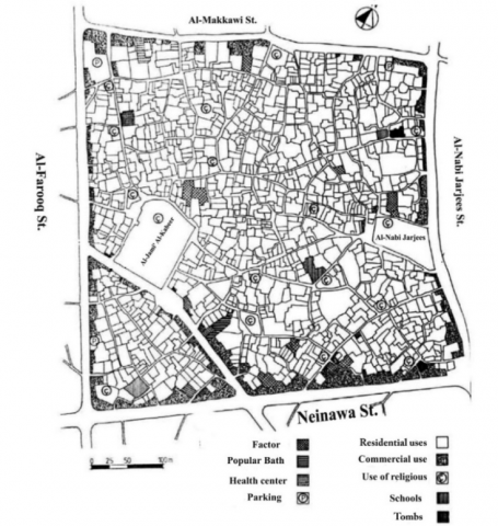
It is an urban area surrounded by four main streets; Al-Makkawi St. from the north, Al-Nabi Jarjees St. from the east, Al-Farooq St. from the west and Nineveh St. from the south, including 12 residential blocks. The Great Mosque of al-Nuri, locally known as 'Al-Jami' Al-Kabir', is the second largest mosque of the old Mosul, which was built by Noor Al-Din Zenki in (566 A.H.-1170 A.D.), with a length of (65 meters) and a width of (17 meters) Figure 2. Al Nuri Mosque lies in the center of Mosul's old city. The " al-Jami' al-Nuri al-Kabir " area is 25 hectares overall, including 1130 neighborhoods.
General Directorate of Urban Planning-Mosul
Figure 2. Map of Al-Jami' al-Nuri al-Kabir area
The most recent studies have started to focus on renovation and renewal of Mosul's old city while preserving its historic characteristics and maintaining its formal architectural aspects. Accordingly, the current study will focus on investigating the systemic aspects of part of the old city (al-Jami' al-Nuri al-Kabir) "The Great Mosque" in order to determine the legibility of the area and to put forward a complete study on how to renovate the city while preserving its systemic aspects, as well as determining places most suitable for the addition of new activities, such as turning old houses into museums, in addition to increasing the legibility of other areas depending on treatment of optical characteristics, such as adding landmarks or dependence on depth diversification - an aspect of old alleyways.
6.1 Description and analysis of space system of an area
Hillier asserts that to understand a city one must understand its material shape, or rather its spatial shape. The material shape can only be understood after understanding imbedded basis of that shape. As for Islamic cities, their spatial structures have basic rules that put together the final shape of the city. By examining space syntax studies, the relationship between aspects of two types of organization; urban organization and visual organization, will be determined.
6.1.1 Basic measurement maps
Earlier studies of principles of space structure mainly depended on axial map as main schemes to conduct structural measurements, as central schemes represent the organization of urban spaces as visual dynamic steps which in turn depend on a basic unit, the axial line, which in turn represent the maximum visibility value, and the direct motion of any point within the urban space in one dimension [15].
6.1.2 Measurement of structural characteristics of space syntax
Studies of space syntax define a number of organizational aspects of relations between elements of spatial organization according to two structural characteristics:
6.1.3 Local & global measurement
Studies of space syntax often produce an approach of structural analysis of relationships between elements of a spatial organization on two levels (local, global). Structural aspects of an element within dynamic organization are measured according to the following standards:
The connectivity of a space within a visual organization or dynamic organization map is measured from the total spaces connected or intercepted with that particular space, i.e. spaces that are one step away from it. Connectivity represents the range of available choices to move directly from one space to other neighbouring spaces.
b- Local Control: is represented by the range of alternative paths provided by a space to reach it from other neighbouring spaces. Local control is measured within the visual or dynamic map from the total reverse connections with neighbouring spaces [15].
A- Integration: integration of a space expresses its relative asymmetry within the spatial system. Relative asymmetry is achieved through deep relationships of a spatial system with other spatial systems. Degree of space integration indicates the range of accessibility from other spaces to this particular space [16].
6.2 Determination of structural and legible cores
6.3 Measurement of legibility
Expresses the relationship between connective local values with inclusive integration values of spaces within a system. Thus, legibility is measured using Pearson coefficient for reciprocal relationship. Theoretically, value of legibility ranges between (+1, -1), with the highest values indicating high degree of legibility. The application of this standard indicates the ability to predict the importance of integration of a space to direct a motion depending on simultaneous sensitivity of visually available information with that space.
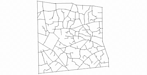
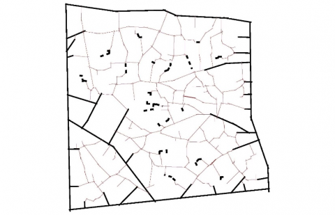
Space syntax principle was used to determine the systemic aspects and legibility of the area under study. For this end, an axial scheme of the area Figure 3 maps and ArcView 3.3 software, which is one of the software associated with GIS system providing high capability in obtaining spatial data of urban areas, were used.
Figure 3. Axial scheme of the study area
7.1 Results
Firstly, the following results have been found:
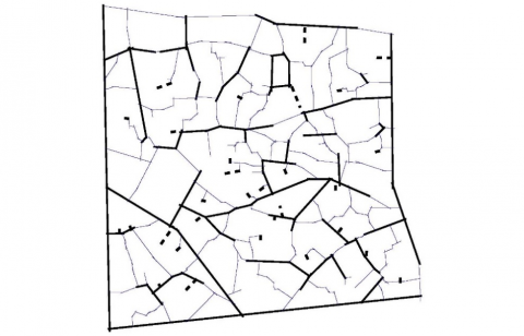
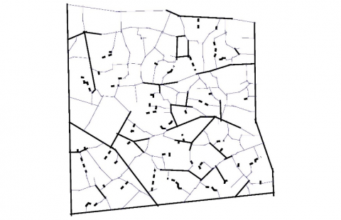
Connectivity Strong core
Connectivity Weak core
Figure 4. Values of connectivity
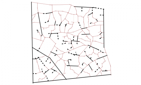
Strong control core
Weak control core
Figure 5. Values of local control
Strong integration core
Weak integration core
Figure 6. Values of integration core
Strong integration-3 core
Weak integration-3 core
Figure 7. Values of integration-3 core
Through the aforementioned results, the following have been concluded:
[1] Lynch, K. (1964). The Image of the City. Mit Press.
[2] Shokouhi, M. (2017). Legibility of the cities and the factors having impacts on it. Int. J. Architect. Eng. Urban Plan, 27(1): 53-63. https://doi.org/10.22068/Ijaup.27.53.63
[3] Bently, I., Alcock, A., Murrain, P., Mcglynn, S., Smith, G. (2005). Responsive Environments. Architectural Press, London.
[4] Hillier, B. (1997). Space is the machine: A configurational theory of architecture. London, United Kingdom: University of Cambridge. https://doi.org/10.1016/s0142-694x(97)89854-7
[5] Al-Nueimi, O. (2007). Legibility In the Urban Environment. Baghdad.
[6] Shokouhi, M. (2003). The role of visual clues and pathway configuration in legibility of cities. In 4th International Space Syntax Symposium London. https://api.semanticscholar.org/CorpusID:56112652.
[7] Downs, R.M., Stea, D. (2017). Image And Environment: Cognitive Mapping and Spatial Behavior. Taylor & Francis. https://doi.org/10.4324/9780203789155
[8] Lang, J. (1987). Creating Architectural Theory: The Role of the Behavioral Sciences in Environmental Design. Van Nostrand Reinhold Company.
[9] Hillier, B., Penn, A., Hanson, J., Grajewski, T., Xu, J. (1993). Natural movement: Or, configuration and attraction in urban pedestrian movement. Environ. Plan. B Plan. Des., 20(1): 29-66. https://doi.org/10.1068/B200029
[10] Rapoport, A. (1977). Human Aspects of Urban Form: Towards a Man-Environment Approach to Urban Form and Design. Pergamon Press, Oxford, New York.
[11] Ching, F.D.K. (2012). Architecture: Form, Space, And Order. Wiley.
[12] Lang, J.T. (1974). Designing for Human Behavior: Architecture and the Behavioral Sciences. Dowden, Hutchinson & Ross.
[13] Ankerl, G. (1981). Experimental Sociology of Architecture: A guide to Theory. Research and Literature. https://doi.org/10.1515/9783110903058
[14] Al-Joma’a, A. (1986). Ancient aspects and designs of Mosul city and their effect on architectural and urban development in the city. Mosul.
[15] Hillier, B., Hanson, J. (1984). The Social Logic of Space. Cambridge University Press. https://doi.org/10.1017/Cbo9780511597237
[16] Hanson, J. (1989). Order and Structure in Urban Space: A Morphological History of the City of London. University of London.