Baydaa Abdul Hussein Bedewy*![]() | Sophia Rezaq Ali Al-Timimy
| Sophia Rezaq Ali Al-Timimy![]()
© 2023 IIETA. This article is published by IIETA and is licensed under the CC BY 4.0 license (http://creativecommons.org/licenses/by/4.0/).
OPEN ACCESS
This paper's significance lies in investigating the multivariate spatial parameters of the service sites for gas stations according to predetermined standards and their spatial location to identify the best place for such services. The present study focuses on fueling stations in Al-Mahaweel City, located in the Babylon Province of Iraq. This case study aims to analyze the problem of inefficiency and inadequacy in serving the fuel stations inside the city. These issues have significant economic and environmental repercussions, ultimately affecting urban sustainability. For this purpose, a spatial database by Geographic Information System (GIS) is used to analyze basic services such as hospitals, schools, and others. As well as agriculture, industry, and residential uses. All that is about to derive the relevant criteria for the organization of the district center, which facilitates analysis and evaluation of their current location. The study results indicated the need for stations within an efficient spatial. So, the specific locations for new filling stations would depend on various factors (Q=4,000 square meters and W=5,000 square meters). Accordingly, this article aims to meet demand based on the essential urban planning indicators to enhance the ease of traffic, avoid road congestion, and promote urban sustainability.
Geographic Information System (GIS), transportation system, fuel stations, spatial dimension, fuel risks, urban sustainability
Transportation is a distinguishing phenomenon in cities, as movement is the artery connecting urban areas [1]. Transportation becomes increasingly important with population growth, urban expansion, and diversifying functional activities in urban centers [2, 3]. The sub-transportation system is integral to logistical services and planning whenever vehicles transport passengers and goods from one space to another [4].
Additionally, the UN's consideration of safety on the road in 2015 added to the list of Sustainable Development Goals (SD Goals) that unveiled how beneficial it was [5].
So, the need for fuel stations to supply cars with motor fuel is increasing [6]. Fuel stations of all types are among the most essential service facilities for transportation. Moreover, an important service must be geographically distributed depending on the traffic flow and road density [7]. Therefore, according to proper planning criteria, the spatial analysis of these station's locations is linked to fair service provision, which affects economic, environmental, and social factors and, thus, urban sustainability [8].
They achieve a suitable level of traffic flow and ease of transportation between cities, provinces within the country, and globally [9]. The location varies depending on the area or country you are referring to. However, in most places, fuel stations are typically found along major highways, busy roads, or urban areas. They may also be near shopping centers, airports, or truck stops. Additionally, you can use navigation apps or websites to find nearby fuel stations specific to your location. At the same time, increased efficiency can reduce energy consumption, carbon emissions, and pollution [10]. Therefore, spatial considerations about geographical distribution are among the most important things impacting their efficiency [11]. Despite this, GIS combines multiple purposes in numerous applications and disciplines to help decision-makers make the best decision as rapidly as possible. This is because of the essential relevance that forms a science concerned with gathering, processing, and analyzing geographic information [12-14]. This study will utilize that to incorporate multivariate spatial parameters into an analysis of the most optimal sites for fuel stations by combining spatial data and descriptive information into an integrated evaluation [14, 15].
Article Problem: Inefficiencies in the areas above can lead to extended travel lengths, heightened waiting periods, discomfort for persons seeking fuel, and diminished service provision for residents and tourists.
Article Hypothesis: Spatial analysis can choose the appropriate location for fuel stations to improve transportation efficiency and effectiveness and reduce energy losses towards urban sustainability.
Article Objective: An optimal spatial location for fuel stations can be selected by analyzing multivariate spatial criteria. This analysis aims to meet the demand for fuel while considering inessential urban planning indicators. The primary objectives of this approach are to improve traffic flow, prevent congestion on roads, ensure the safety of citizens, mitigate pollution, and foster urban sustainability.
The comparison analysis suggests that the publication likely presented procedural guidelines to enhance gasoline station spatial distribution. The proposals potentially encompassed several tactics aimed at finding appropriate locations for new stations, formulating rules for the placement of gasoline stations, and devising incentives to encourage fuel providers to extend their services in regions that lack sufficient coverage.
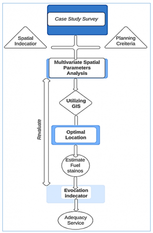
The article utilized a comparative analysis approach to examine planning criteria and indicators to provide recommendations for addressing the problems associated with the inadequate regulation of fuel events in the city. A GIS was employed to analyze the optimal locations for suggested fuel stations, as shown in Figure 1.
Figure 1. Methodology
Fuel stations are designed to align with the unique characteristics and fueling requirements of different types of transportation means, ensuring they have the necessary resources to operate efficiently [10, 14]. Besides, they serve as starting stations to distribute traffic flow directions [16]. For car traffic, fuel stations are a primary source within the street network as they supply vehicles with fuel [17]. Fuel stations catering to cars and trucks might have larger fueling bays and pumps capable of quickly dispensing large fuel volumes.
They may also offer amenities and services like convenience stores, car wash facilities, and restrooms to accommodate drivers and passengers [18, 19]. Consequently, the effect on the economy and environment [15].
3.1 The importance of fuel stations
The importance of fuel stations can be summarized below:
3.2 Fuel station risks
The fuel sold at fuel stations of all types is a marketable commodity that falls within the retail trade due to the increasing demand from investors to establish fuel stations [19]. Besides, the large number of fuel stations located in residential neighborhoods poses significant risks with impacts on workers and people in general [12, 20].
It is known that fuel is a highly flammable substance, whether in gas or liquid form. Additionally, fuel-filled tanks in fuel stations are temporary ready-to-explode bombs once the triggering factor is present. In the event of an explosion, it can lead to a disaster due to environmental impacts that were not considered [21, 22]. The responsible authorities still need to ensure safety elements from environmental and spatial perspectives [20].
4.1 Worksite
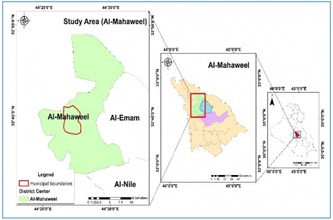
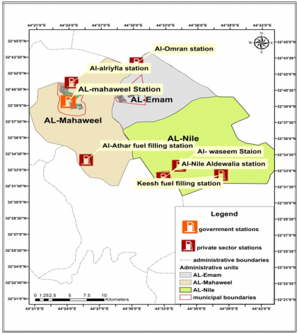
The study area includes the Al-Mahaweel in Babylon, Iraq. That lies in longitudes (45° 6' 40''-44° 20' '50'' E) and latitudes (32° 49' 20''-32° 25' 20'' N). The district is about 20 km north of Al-Hilla City and 80 km from Baghdad [23, 24]. The total area covered was about 1667 km², which accounts for 33% of Babylon province's total area almost (5119 km²). The district comprises four administrative units: Al-Mahaweel, Al Mashru', Al-Imam, and Al- Nile [25], as shown in Figure 2.
Figure 2. Al-Mahaweel centre, ArcGIS 10.6
4.2 Demographic information
Demographic data provides information about the area's population size, density, growth, and organizational settlements. Studying population characteristics and growth rates is essential for understanding the future impact on the provision of fuel stations. By analyzing population trends, we can make informed decisions about fuel station locations, identify underserved areas, adapt to changing transportation trends, and anticipate future demand. This knowledge allows fuel station providers to offer better services that align with the population's natural growth and cater to their customers' evolving needs [26], as shown in Table 1.
Table 1. People in Al-Mahaweel in (1987, 1997, 2021)
|
Administrative - Unit |
Period |
Population |
|
Mahaweel D.C. |
1987 |
42,326 |
|
1997 |
74,480 |
|
|
2021 |
131,556 |
Source: population estimates for 1987, 1997, and 2022
From Table 1, the demographic change shows that the population increased after 1997 due to the natural growth of the Al-Mahaweel region [26]. As a result, the Al-Nile sub-district was added to the Al-Mahaweel district.
4.3 Fuel stations survey
Fuel stations are spread throughout Al-Mahaweel District, encompassing the government and private sectors. The existence of only three stations in this district has caused disruptions and challenges in service delivery efficiency due to administrative expansions and changes in the districts. Separating sub-districts from the main district disrupts service distribution and the available range. Table 2 shows three fuel stations that offer petroleum products.
Table 2. Fuel in Al-Mahaweel according to units in (2021)
|
Administrative-Unit |
Num. of Filling Station |
|
Mahaweell |
3.00 |
|
Nele sub-district |
3.00 |
|
Imaim sub-districts |
1.00 |
|
Totally |
7.00 |
Sources: directorate of oil/statistics (2021), (unpublishing data)
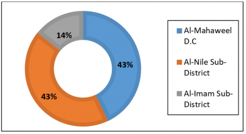
Figure 3. Ratios of stations in the area, based on the data provided in Table 1
Figure 3 above illustrates that Al-Mahaweel has a low percentage of filling stations, which contradicts the importance of its administrative and geographical location. The district is a significant transit area connecting Babylon province with provinces, making it more crucial and requiring fully-equipped fuel stations. The station data is presented in detail based on ownership, location, and products available, as in Table 3 and Figure 2.
4.4 Classification of fuel stations
Table 3. Classification in Al-Mahaweel City according to ownership
|
Administrative-Units |
Names |
Types |
Boundarie |
|
Mahaweel D.C. |
Al-Alriyfia station |
Private sector |
Out |
|
Mahaweel station |
Government sector |
Within the boundary |
|
|
AL-Athar |
Private-sector |
Out |
Sources: Directorate of oil Stations Statistic for (2021), unpublished data
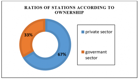
Table 3 and Figure 4 show that the majority percentage consists of private stations, which accounted for approximately 67%, distributed across the district center. Following that, the percentage of government-owned stations amounted to 33%, indicating an imbalanced ratio between the types.
Figure 4. Ratio of stations according to ownership
Figure 5 shows the analysis of filling in districts and sub-districts, Al-Nile and Al-Imam, and their impact on the center of Al-Mahaweel district.
Figure 5. Refueling stations in Al-Mahaweel district and neighboring centers, ArcGIS 10.6
4.5 Offered products
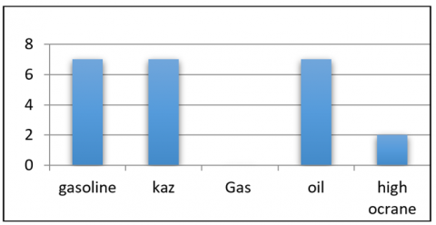
Table 4 and Figure 6 show filling stations and product processing.
Table 4. Offered product
|
Station |
Station Property |
Products |
||||
|
Gaso. |
Gas. |
Kaz. |
Oil. |
High Octane |
||
|
Al-alriyfia station |
Priv. sector |
* |
|
* |
* |
|
|
Al-mahaweel station |
Gov. sector |
* |
|
* |
* |
|
|
Al-waseem station |
Priv. sector |
* |
|
* |
* |
|
Source: Directorate /Petroleum Stations for 2021, unpublished data
Figure 6. Filling stations and product processing, based on Table 4
4.6 Multivariate spatial parameter analysis
The preceding data has been analyzed using the comparative analysis method based on the Ministry of Oil's 2015 standards, dividing the standards into criteria for stations located within and outside municipal boundaries, as per experts and decision-makers, as shown in Table 5.
A) Oil's standards within and out of the boundaries
B) Optimal fuel station location
Reducing differences in levels of development through the organization of multiple actions, directing the locations of events and development efforts, and policies and strategies that integrate economic, social, political, and cultural factors can lead to sustainable and inclusive spatial outcomes, ensuring that the spatial dimension meets the diverse needs and aspirations of individuals and communities. And in particular, environmental, to achieve sustainable development.
Therefore, the organization of land uses leads to a spatial balance of services and increases efficiency within the same urban area. This is the reason for choosing the optimal location for gas stations. Considering the spatial dimension as a basis for service provision helps ensure that services are efficiently delivered and accessible to the community; service providers can tailor their strategies to meet the population's diverse needs and provide efficient and effective services.
C) Determining the optimal location
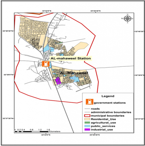
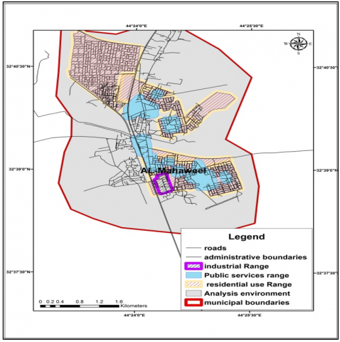
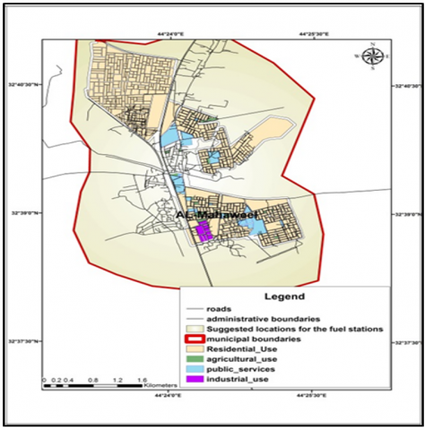
The analysis environment plays a crucial role in designating areas for land use and other services. It involves data collection, GIS technology, spatial analysis techniques, policy consideration, stakeholder engagement, and evaluating trade-offs. By employing a comprehensive analysis environment, informed decisions can be made to designate areas that meet the community's needs while considering various constraints and objectives, as shown in Figure 7. The range of buffer zone for each service is determined, and the distances of the stations from it are indicated, as shown in Figure 8. The analysis area was the optimal location from the analysis layer to determine the model site for the station based on the criteria shown in Figure 9. The ideal station estimated location is chosen in Figure 10, as shown in Tables 6 and 7.
In Figure 7, survey the land use in Al- Mahaweel district to spatial optimal location analysis.
In Figure 8, drawing the rings as an index of multivariate location parameters from Table 5 and location index Survey to land use Figure 7 in Al-Mahaweel district.
In Figure 9, shown is the analysis for reducing suitable areas for optimal location with the city's land use.
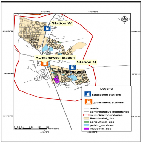
In Figure 10, the spatial location analysis results show the best (estimated stations Q and W) as the best location for providing adequate service as spatial location analysis.
Table 5. Oil's standards for stations
|
Criterions |
Cursors |
The Index |
|
In the Boundarie |
||
|
Residential uses |
The distances |
(40) M |
|
People |
For (60,000) people |
(2) |
|
Community- service |
The distances from (the school, hospital, and mosque) |
(100) M |
|
Road networks |
Distances to traffic intersection |
(1,000) M |
|
Arrival distances |
The beneficiary's distances |
(1,600) M |
|
Distances of the stations from each other |
Distances on the same streets |
(750) M |
|
Out Boundarie |
||
|
Distances from each other |
Distances in same administrative units |
(10) KM |
|
Distances from the electrically line |
Distances from high electrical pressures area |
(10) M |
|
Distances from low electrical pressures area |
(5) M |
|
Source: Regulations and conditions for establishing updated fuel stations for the year 2015 for the Ministry of Oil, published data
Figure 7. Al-Mahaweel district reality present survey land use, ArcGIS 10.6
Figure 8. Buffer zone for multivariate parameter locations in the Al-Mahaweel district, ArcGIS 10.6
Figure 9. Spatial optimal locations analysis to get estimated station in the Al-Mahaweel district, ArcGIS 10.6
Figure 10. Estimated stations for Al-Mahaweel district, ArcGIS 10.6
Table 6. Evaluate estimated station Q in the capital area of Al-Mahaweel district according to the ministry of oil's standards
|
Station Q |
Indexes |
The Standards Index |
Evaluation to Standard |
|
The Spaces |
4,000 |
2,000 M2 or more |
Match the standard |
|
Distances to the residential uses |
40 M |
40 M |
Match the standard |
|
Distances from the (school, hospital and health center) |
100 M |
100 M |
Match the standard |
|
Industrial use |
55 M |
40 M |
Match the standard |
|
Distance the station |
1,125 M |
750 M |
Match the standard |
|
Arrival distances |
1,600 M |
1,600 M |
Match the standard |
|
The dimensions of Administrative uses |
100 M |
100 M |
Match the standard |
Table 7. Evaluate estimated station W in the capital area of Al-Mahaweel district according to the ministry of oil's standards
|
Station W |
Indexes |
The Standards Index |
Evaluation to Standard |
|
The Spaces |
5,000 |
2,000 M2 or more |
match the standards |
|
Distances to the housing units |
40 M |
40 M |
matches the standard |
|
Industrial uses |
40 M |
100 M |
matches the standard |
|
Distances (school, hospital and health center) |
100 M |
40 M |
matches the standard |
|
Distance between the station |
985 M |
750 M |
matches the standard |
|
Arrival distances |
1,600 M |
1,600 M |
matches the standard |
|
The dimensions from Administrative uses |
100 M |
100 M |
matches the standard |
As evaluation (estimated stations Q and W) according to the standard index as a distance to the service as a school, hospital, or another sector as industrial or residential use. So, this station was in the range of the index. According to the calculation, the distance between the station and the distance of arrival was accepted in the range as well as the area. So, the evaluation of this station in the optimal location, and within the expected efficiency of the service.
1) Planning criteria serve as a measure to provide a vibrant urban environment sustainable for residents' livelihoods.
2) The requirement for fuel stations increased in the district of Al-Mahaweel with the number of residents increasing and the rapid expansion of the area of the district after the addition of the Al-Nile sub-district that appears in the table of demographic increase between 1997-2021, which increased pressure on the center of Al-Mahaweel. In addition, there was a rise in transit traffic on the main highway linking the provinces of Baghdad and Basra, passing through the province of Babylon, which increased the importance of the district center.
3) A spatial multivariate parameter analysis was used to estimate the region's station needs. Here, it required the establishment of two stations that were proposed: W Q; the two stations were signed to the north and south of the Al-Mahaweel district to achieve the criterion of distance according to the Oil and Gas Standards 2015 and appropriate spatial criteria for basic services such as health, education, and residential. In addition, it provides the appropriate distance from the agricultural and industrial sectors to achieve the optimal location for the efficiency and adequacy of service, thus achieving urban sustainability.
4) There is a need for more fuel stations compared to the demand in the province despite their significant economic importance.
5) Most stations are out of the boundaries, indicating a need for more services for residents in the surrounding areas and the district center.
6) Using multivariate spatial parameter analysis to locate the stations in the appropriate places provides the appropriate location for the gas stations. It thus achieves the hypothesis of research in reducing the distance traveled and thus achieving urban sustainability.
[1] Gichaga, F.J. (2017). The impact of road improvements on road safety and related characteristics. IATSS Research, 40(2): 72-75. https://doi.org/10.1016/j.iatssr.2016.05.002
[2] Rindone, C., Panuccio, P. (2023). Planning for risk reduction in the transport system at urban level. International Journal of Transport Development and Integration, 7(1): 27-34. https://doi.org/10.18280/ijtdi.070104
[3] Lepuschitz, W., Groessing, B., Merdan, M. (2015). Automation agents for controlling the physical components of a transportation system. In Industrial Agents, Morgan Kaufmann, 323-339. https://doi.org/10.1016/B978-0-12-800341-1.00018-8
[4] Di Giangi, M., Belcore, O.M., Polimeni, A. (2023). An overview on decision support systems for risk management in emergency conditions: Present, past and future trends. International Journal of Transport Development and Integration, 7(1): 45-53. https://doi.org/10.18280/ijtdi.070106
[5] Wegman, F. (2017). The future of road safety: A worldwide perspective. IATSS Research, 40(2): 66-71. https://doi.org/10.1016/j.iatssr.2016.05.003
[6] Zhao, Q.S., Kelley, S.B., Xiao, F., Kuby, M.J. (2019). A multi-scale framework for fuel station location: From highways to street intersections. Transportation Research Part D: Transport and Environment, 74: 48-64. https://doi.org/10.1016/j.trd.2019.07.018
[7] Huang, Y.X., Li, S.Y., Qian, Z.S. (2015). Optimal deployment of alternative fueling stations on transportation networks considering deviation paths. Networks and Spatial Economics, 15: 183-204. https://doi.org/10.1007/s11067-014-9275-1
[8] Kadhim, A.A. (2022). Spatial analysis of the distribution of petrol filling stations for part of the outer road (Baghdad-Hila). RESS Journal Route Educational & Social Science Journal, 9(4): 537-551.
[9] Upchurch, C., Kuby, M., Lim, S. (2009). A model for location of capacitated alternative‐fuel stations. Geographical Analysis, 41(1): 85-106. https://doi.org/10.1111/j.1538-4632.2009.00744.x
[10] Picone, M., Busanelli, S., Amoretti, M., Zanichelli, F., Ferrari, G. (2015). Advanced technologies for intelligent transportation systems. Springer International, Switzerland, 30: 238. https://doi.org/10.1007/978-3-319-10668-7
[11] Al-Jameel, H.A., AL-Maliki, L.A., Al-Mamoori, S.K., Al-Ansari, N. (2023). Spatial analyses model for the public transportation and the urban form relationship. In AIP Conference Proceedings, AIP Publishing, 2651(1): 020002. https://doi.org/10.1063/5.0133659
[12] Soha, T., Hartmann, B. (2022). Complex power-to-gas plant site selection by multi-criteria decision-making and GIS. Energy Conversion and Management: X, 13: 100168. https://doi.org/10.1016/j.ecmx.2021.100168
[13] Tran, T.H., Nagy, G., Nguyen, T.B.T., Wassan, N.A. (2018). An efficient heuristic algorithm for the alternative-fuel station location problem. European Journal of Operational Research, 269(1): 159-170. https://doi.org/10.1016/j.ejor.2017.10.012
[14] Tercan, E., Eymen, A., Urfalı, T., Saracoglu, B.O. (2021). A sustainable framework for spatial planning of photovoltaic solar farms using GIS and multi-criteria assessment approach in Central Anatolia, Turkey. Land Use Policy, 102: 105272. https://doi.org/10.1016/j.landusepol.2020.105272
[15] Saad, A.H., Abbas, H.A-A. (2014). Spatial analysis of fuel filling stations in the holy city of Najaf using GIS. Journal of the University of Kufa, Iraq.
[16] Jassim, I.A. (2014). The spatial distribution of gas stations and its relationship to the urban environment-the city of Kut as a model. Wasit Journal of Human Sciences, 26: 437-460. https://swideg-geography.blogspot.com/2015/12/blog-post_7.html.
[17] Al-Atabi, Shaalan, I.A.H. (2013). Geographical distribution of petrol filling stations in Al-Najaf governorate. Kufa Journal of Arts, 1(16): 357-383. https://doi.org/10.36317/kaj/2013/v1.i16.6270
[18] Ihsan, A.J., Mustafa, A.E., Akeel, A.A. (2020). The impact of the distribution of fuel stations on the urban environment case study Kut-Iraq. In IOP Conference Series: Materials Science and Engineering, IOP Publishing, 737(1): 012190. https://doi.org/10.1088/1757-899X/737/1/012190
[19] Glazener, A., Wylie, J., van Waas, W., Khreis, H. (2022). The impacts of car-free days and events on the environment and human health. Current Environmental Health Reports, 9(2): 165-182. https://doi.org/10.1007/s40572-022-00342-y
[20] Shen, Z., Shen, D., Xiong, G., Wang, F.Y. (2012). Overview of service science, management, and engineering. In Service Science, Management, and Engineering, 2012: 1-9. https://doi.org/10.1016/B978-0-12-397037-4.00001-6
[21] Shi, J.H., Chang, Y.J., Khan, F., Zhu, Y., Chen, G.M. (2020). Methodological improvements in the risk analysis of an urban hydrogen fueling station. Journal of Cleaner Production, 257: 120545. https://doi.org/10.1016/j.jclepro.2020.120545
[22] Ahmed Ali, K. (2018). Multi-criteria decision analysis for primary school site selection in Al-Mahaweel district using GIS technique. Journal of Kerbala University, 16(1): 342-350.
[23] AlTaee, H.A.J., Edan, B.J., Al-Sallami, D.W. (2022). Prevalence and risk factors of infertility in women from Al-Mahaweel district, Babylon\Iraq. International Journal of Science and Research Archive, 5(2): 96-102. https://doi.org/10.30574/ijsra.2022.5.2.0042
[24] Bedewy, B.A.H., Abdulameer, M.H. (2023). Evaluating and improving the spatial distribution using GIS to avoid environmental risks and achieve safety for petrol stations in the Nile district center in Mahaweel / Iraq. International Journal of Safety and Security Engineering, 13(3): 433-444. https://doi.org/10.18280/ijsse.130306
[25] Bedewy, B.A.H., Al-Timimy, S.R.A. (2023). Estimate suitable location of solar power plants distribution by GIS spatial analysis. Civil Engineering Journal, 9(5): 1217-1229. https://doi.org/10.28991/CEJ-2023-09-05-013
[26] Al-timimy, S.R., Al-Rawe, M. (2020). Evaluate education in the Marshes of Southern Dhi-Qar toward a new paradigm of sustainability. In IOP Conference Series: Materials Science and Engineering, 737(1): 012199. IOP Publishing. https://doi.org/10.1088/1757-899X/737/1/012199