Baraah Moutaz Hamdoon | Khaled Galal Ahmed*![]()
© 2023 IIETA. This article is published by IIETA and is licensed under the CC BY 4.0 license (http://creativecommons.org/licenses/by/4.0/).
OPEN ACCESS
Mobility measures have an influential impact on urban social sustainability. This has not been investigated enough in the recent urban waterfront redevelopment projects in United Arab Emirates (UAE). This research aims at first initiating an assessment method for the mobility measures on both the morphological/urban form and urban design levels. Then, it aims at applying this assessment method on Mina Zayed (Zayed Port) waterfront urban regeneration project in Abu Dhabi, as a selected case study. The assessment method relied on an established theoretical framework that defined the principles and indicators of both the mobility morphological measures including Compactness and Density, Mixed-Use Development, Accessibility, and Mobility Networks Connectivity and Integration on the one hand, and the urban design mobility measures including Comfort and Livability, Environmental Quality, Safety and Security on the other hand. The utilized qualitative/quantitative tools of the adopted Case Study method encompassed the expert analysis of the CAD design drawings, Space Syntax Theory application through the DepthmapX simulation variables of Step Depth, Choice and Integration. The initiated assessment method managed to reveal the challenges and potentials of the investigated mobility measures in the analyzed case study. Based on these outcomes, a set of enhancement strategies for mobility measures on both morphological scale and urban design scale has been recommended. These included, among other measures, improving the infrastructure for non-motorized modes of mobility, enhancing mixed land-use of the design, having a more integrated mobility grid and improving accessibility. The research findings proved the validity of the applied assessment method, with its relevant investigation tools, makes it a legitimate revising method for the waterfront urban regeneration designs in the UAE, and in other countries in the region to help significantly enhance the attainment of social sustainability in waterfront urban regeneration projects.
mobility, social sustainability, UAE, urban redevelopment, waterfront development
It is widely acknowledged that urban regions experience continuous social, economic and environmental transformations [1]. Such transformations cause inevitable urban dilapidation and hence necessitate urban redevelopment to rectify it. Urban redevelopment processes for dilapidated areas usually begin with determining the essential problems and the needed actions to solve them on the various social, economic and environmental levels [2]. An important segment of this urban redevelopment process is the urban regeneration of waterfront regions especially old ports because they have the potential to sustainably reutilize the available vast abandoned land in attracting new mixed land uses that significantly benefit existing urban communities [2, 3].
On the other hand, the 17 sustainable development goals (SDGs) tailored by the United Nations in 2015 have risen to the top of national agendas across the world focusing mainly on enabling access to clean energy, adequate and affordable food, quality education, health care, sustainable economic growth, healthy ecosystems and increased resource efficiency which are targeted to enhance the well-being of citizens. The UAE has signed the SDGs framework and developed its 2030 National SDGs Agenda, establishing dedicated governance, and implementing numerous projects with a commitment to fully attain the 17 goals of the agenda by 2030.
The UAE government has achieved some considerable progress through this local agenda especially in SDG 11 ‘Sustainable Cities and Communities’. Still, these achievements are limited to some new sustainable initiatives such as Masdar City in Abu Dhabi and The Sustainable City in Dubai [4, 5]. Unfortunately, the focus of these initiatives has been mostly devoted to achieving environmental sustainability with much less attention to social sustainability.
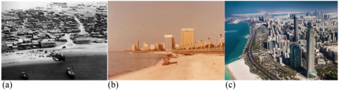
As part of these SDG 11 and previous urban sustainability-related local agendas, major cities in the UAE such as Abu Dhabi, the capital city, Dubai, Sharjah, etc., have recently initialed ambitious plans for redeveloping their old ports and lengthily coastal areas to facilitate their transformation from the historical socio-economic activities into modern mixed-use sustainable urban areas. From 1962 until today, Abu Dhabi has started to develop most of its urban infrastructure near the waterfront regions, which have been the main concentration spots of the city population [3] (Figure 1).
Figure 1. Urban transformation of Abu Dhabi waterfront areas in: (a) 1960, (b) 1985 and (c) 2021
(Source: a, b [6], c [7])
Figure 2. The location and site boundary of the Mina Zayed in Abu Dhabi city
In the 1980s, the waterfront area of Abu Dhabi city attracted the attention of the developers, planners and residents. Since then, a five-kilometers long coast land has been developed to form a prominent Corniche and a waterfront park along the Arabian Gulf coastline. According to the Abu Dhabi 2030 Master Plan, developed in 2007 by the Abu Dhabi Urban Planning Council, the area of the old port of the city known as Zayed Port or Mina Zayed in Arabic (Figure 2) is planned to be transformed into a mixed-use urban region encompassing businesses, touristic facilities, residential development, entertainment and cultural facilities, etc., to ultimately be part of the new Abu Dhabi Central Business District (ADCBD). Meanwhile, the new Khalifa Port is planned to replace Mina Zayed as the official trade and commercial port of the city. The new ADCBD, including Mina Zayed, will be connected to the whole urban agglomeration of the city by developed transportation infrastructure and a modern transit system [3].
As a significant component of the waterfront urban regeneration process, mobility with its various modes including walkability, micro-mobility (cycling, riding scooters/e-scooters, etc.), public transportation and private vehicles, should be all appropriately considered in an integrated manner to contribute to achieving social sustainability in waterfront urban redevelopment projects. Besides pedestrian mobility, boosting micro-mobility means of travel within urban contexts is an essential factor in realizing social sustainability. Such modes of local mobility require the provision of dedicated networks that are safe, pleasant and secure. On the other hand, accessible, affordable, rapid and reliable public transport backs the development of sustainable urbanism within the urban (re)development site (waterfront) and as a linkage with the surrounding urban areas and the city civic center. Additionally, while this sustainable private vehicular travel is still allowed, its mobility network should be less permeable compared to other more sustainable travel modes of pedestrian mobility and micro-mobility [8].
In most waterfront urban redevelopment schemes all over the world the economic and environmental aspects used to receive the chief attention with little consideration given to social dimensions. But this situation has recently changed as social measures in waterfront urban redevelopment projects started to receive increasing attention [9]. Unlike the case globally, waterfront urban redevelopment experiences in the UAE have not received enough attention yet from researchers especially in studying the realization of the sustainability aspects of the recent waterfront urban redevelopment projects in general and the social sustainability aspects in specific in line with the UAE’s effort to achieve the SDG 11: ‘Sustainable Cities and Communities’, among the overall 17 SDGs by 2030. The main objective of this research is to humbly contribute to this missing research work with concentrating on bridging this gap to achieve SDG 11, especially through investigating the impact of the integrated urban mobility measures on social sustainability from both the morphological/urban form and urban design perspectives. Meanwhile, the ultimate goal of the research is to establish a reliable assessment method for the integrated mobility measures that could be effectively utilized to define the inadequacies and opportunities for enhancement in developing socially sustainable waterfront urban regeneration projects while they are still in the design phase in waterfront urban regeneration redevelopment projects in the UAE and other Arabian Gulf cities.
Figure 3. (a) The location of the Mina Zayed waterfront redevelopment project, and (b) the land-use plan of the redevelopment design by Sasaki Architects [11]
The Case Study Method was adopted in this research to effectively investigate the multifaceted social dynamics and the social impacts of the mobility measures within the studied urban local context. The selection of the design of Mina Zayed urban redevelopment in Abu Dhabi [10] as a case study in the research is attributed to its representation of the most recent waterfront urban redevelopment in the UAE as one of the four major ports in the Emirate of Abu Dhabi. It is also a prominent project that reflects the very recent tendency in sustainability consideration in this type of redevelopment project.
The construction of the old Mina Zayed was originally completed in 1968 in a coastal location to the northeast of Abu Dhabi city. With its distinctive Dhow Harbor, the port once witnessed thriving fish and pearl trading activities. Designed by Sasaki Architects, the very recent and pedestrian-oriented urban regeneration of the old port has a total development area of about 51 hectares and a total floor area of the mixed-use buildings of about 560,000 sq.m [11]. The design interlinks multi-functional zones through integrated open spaces and a waterfront promenade. Besides the local community residents, the mixed-use design (Figure 3), aims to serve a wide spectrum of users including visitors from neighboring areas and tourists. Accordingly, the provision of local facilities, services and job opportunities for the targeted middle-class residents is considered in the design alongside the touristic amenities and hotels. In its West end, the project design has a cylindrical-shaped hotel complex that oversees the surrounding islands and the city. The main facilities are located in the middle blocks that contain apartment buildings, retail facilities, hotels, meeting halls, ballrooms, etc. (Figure 3).
As detailed in the following section, the assessment of the mobility measures in the design of the Mina Zayed urban redevelopment project was guided by a constructed theoretical framework for the main principles and indicators of the mobility measures related to the morphological/urban form as well as the urban design. A combined set of qualitative and quantitative tools were used in this assessment. These tools included the qualitative and quantitative analysis of the CAD drawings and the quantitative analysis of the simulation results of the DepthmapX software [12].
To develop a theoretical framework of a matrix of morphological/urban form and urban design integrated mobility measures that cater for social sustainability in waterfront urban redevelopment projects, and which could be utilized as a mobility assessment tool for waterfront urban regeneration projects, the related literature review was undertaken to develop these mobility measures. Nonetheless, because of the available literature pertaining to socially sustainable waterfront urban redevelopment, some of the measures could have been inadvertently missed out in this framework.
3.1 Morphological mobility-related measures
3.1.1 Compactness and density
Compactness of the urban form and reasonably population-dense development are wellrecognized measures for attaining sustainable and integrated modes of mobility [13]. The compactness of the urban form usually lowers the need for travel within the urban area where walking, cycling and micro-mobility, as eco-friendly modes of travel, are better encouraged when the physical distances among locally provided amenities and destinations are smaller. Additionally, the population and built-up densities significantly contribute to the determination of the appropriate type of public transportation, such as trains, trams and/or buses [14]. The appropriate gross population density is estimated to range between 50 to 60 persons per hectare (PPH) to be adequate to economically support the locally provided community amenities, open spaces and mass transportation [15]. Meanwhile, the floor-area-ratio (FAR) is a recognized measure for the compactness of urban forms where its value is a result of dividing the total floor areas of buildings by the gross area of the development site [16]. Furthermore, in a compact urban form, transport corridors and nodes will be concentrated around central public spaces with fully built-up street frontages and will be graded through to low-density dwellings on the outer urban edge [15].
3.1.2 Mixed-use development
Mixed-use development simply means the establishment of multiple functions including besides housing the needed social, commercial and recreational amenities that are accessible for the whole factions of the local community and are connected by various modes of mobility [17]. As an essential contributor to socially sustainable urbanism, a mixed-use development preferably provides local services and public open spaces around the public transport stations. This would make access to local services and amenities much easier by walking, cycling, or via a micro-mobility device [3]. Encouraging local travel through walkability, micro-mobility and public transit would increase encountering and casual meetings of residents which usually result in stronger social bonds and vivid community networks [18]. Finally, the UN-Habitat recommended floor area function dissemination in mixed-use plans to be as follows: economic activities 40–60%, housing 30–50% and local amenities 10% [19].
3.1.3 Accessibility
Accessibility to local amenities in waterfront developments is a highly significant mobility measure. Walking catchment distances to local amenities and public transport nodes usually range between 300 and 800 m. Meanwhile, local services and facilities should be centrally located near to main transport nodes with stop intervals of about 300 m within the development area. Ease of mobility access to all facilities and activities within the waterfront development and within the city center should be considered for all residents and visitors including women, children, elderly and disabled people [20].
Locally, the Abu Dhabi Public Realm Design Manual defines some design guidelines for the development of waterfront urban areas that aim at achieving a hierarchical presence of accessible and diverse local services and facilities for residents, visitors and tourists. These guidelines also assert the local heritage identity of open spaces [10]. As per these guidelines, on the local waterfront neighbourhood level, the trails to amenities should be integrated into the neighborhood, besides the existence of a neighbourhood coastline access, footpaths in main areas and green open spaces. As for the location, local amenities should be dictated by proximity to the waterfront neighbourhood center with a catchment radius that ranges between 0.5 and 2 km, while the Level of Service (% of accessible waterfront frontage) should range between 10 and 15% of the neighborhood. Meanwhile, on the waterfront district level, the amenities will have trail access, besides the existence of district access to the coastline, a smaller promenade and green open spaces. As for the location, the local amenities should be close to medium density developed areas and be centrally located along a district’s edge with a catchment radius of 5 to 10 km. Meanwhile, the Level of Service should range between 10 and 15% of the district [10]. On the other hand, as stated in the Abu Dhabi Public Realm Design Manual, a variety of built forms and public open spaces should have direct access to all adjacent streets with connected pedestrian and micro-mobility networks for all types of users.
3.1.4 Connectivity and integration of mobility networks
The well-connected and spatially integrated mobility networks in waterfront urban development encourage ease of movement for residents and visitors alike through choosing the appropriate mode of mobility they prefer [10]. These connected, integrated and permeable mobility networks conveniently and continuously link the inner urban areas together and connect them with both the surrounding neighborhoods and the city center [15].
3.2 Urban design mobility measures
3.2.1 Comfort and livability
Comfort and livability of the urban development are achieved through the balanced interrelation between mobility, accessibility and safety [21]. Sustainable mobility and transportation systems help achieve physical, psychological, thermal and visual comfort in waterfront redevelopment projects. So, to encourage people to walk and/or rely on micro-mobility instead of using their private cars, a car-free site provided with the necessary infrastructure for an integrated mobility system should be developed and supported by connected public open space and pleasant streetscape. In hot climates, such as in Abu Dhabi city, shading should be provided to walkways and cycle tracks, with seating areas along with the mobility network. The design and location of shade structures, and buildings should take account of the prevailing wind, solar paths throughout the day, the adjacent structures and landscape elements [10]. Water features, greenery and shadow casting trees are among the passive strategies to moderate the outdoor temperature of pedestrian pathways or cycling lanes. Moreover, livability along mobility routes in the waterfront redeveloped site should be emphasized by the expression of local culture, history and ecology. All could be expressed through locally distinctive waterfront landscape elements and treatments [20].
3.2.2 Environmental quality
It is important for waterfront urban regeneration projects to preserve high quality in both natural and built environments. Encouraging non-motorized mobility modes helps attain this target. While this will preserve the purity of air in the natural environment, high quality of the built environment could be achieved by the availability, convenience, safety and attractiveness of pedestrian and cycling facilities [15].
3.2.3 Safety and security
Safety and security are considered two essential pillars of social sustainability in urban development. Movement networks in the design of waterfront urban regeneration projects should be safe and secure to use for all local community residents and visitors. Safety and security measures usually include urban surveillance, traffic calming techniques and other safety measures for all modes of mobility in the waterfront urban regeneration plan [22]. Besides considering adequate car speed limits, a clear distinction of driveways from pedestrian and micro-mobility pathways using landscape features or parking lots, etc., should be implemented. Moreover, street realms and crossings should be safe and appropriate for all residents and visitors through the ‘universal design’ consideration that contemplates the needs of women, people of determination, elderly people and children [22]. Permeability of the non-motorized mobility networks and public transport routes, as well as the effective ‘natural’ surveillance of streets and walkways, are fundamental measures in this regard as well. In addition, public transport nodes, such as bus or tram stops, should be well-lit and well-connected with mobility networks [10].
4.1 Summarized assessment of morphological/urban form mobility-related measures
The Compactness and Density of the built-up area of Mina Zayed waterfront redevelopment project were assessed by calculating its FAR, while the Mixed-Use Development was assessed through the researchers’ expert analysis of the CAD drawings of the land-use design. On the other hand, DepthmapX simulation was used to assess Accessibility, Connectivity and Integration of mobility networks. For Accessibility, the existence of networks for various modes of mobility was first analyzed. Then, the shortest angular paths were computed from a selected segment (representing a destination of service or a public transport node) to all other segments (mainly residential) within the whole urban spaces of the project’s design. The resulted Step Depth values indicated the catchment distances for all urban segments. Moreover, the assessment of the Accessibility of the urban system of the project was performed through calculating Choice values from DepthmapX simulation. For assessing the Connectivity and Integration of the designed mobility networks, the Integration values obtained from the angular segment analysis were used. All these measures were calculated for the whole urban form of the project (Rn) and for other catchment radii of R400, R600, R800 and R1000 m, as relevant [9].
4.1.1 Assessment of compactness and density
As mentioned above, the analyzed area of the project is almost 51 hectares (about 126 acres) with a gross floor area of buildings of about 562,000 sq.m. So, the FAR of the project is 1.65, which indicates a reasonable built-up density and compactness.
4.1.2 Assessment of mixed-use development
As shown in Figure 4, the master plan of Mina Zayed waterfront redevelopment project is a relatively compact urban form consisting of primary and secondary mixed uses, local and global transactions, as well as public and private spaces. Appropriate density is essential to the viability of the mixed land-use design, where the relatively high density in the project’s mixed-use design is expected to considerably increase the demand for various types of services and facilities with diverse quality, and consequently the availability of job opportunities. Still, it is noticed that some local amenities like schools and clinics are not considered in the design.
Figure 4. The Ground Floor plan of Mina Zayed waterfront redevelopment project showing the mixed land use
4.1.3 Assessment of accessibility
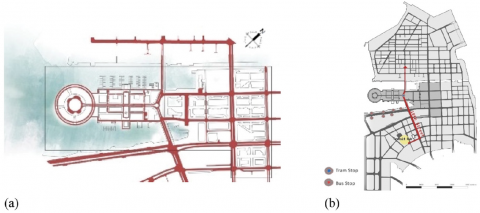
The design has a pedestrian movement network that is well-connected with the provided facilities from various directions, and it is well-integrated with the waterfront as well (Figure 5a). On the other hand, there is no dedicated network for cycling and other micro-mobility modes. So, cycling and micro-mobility would share the pedestrian lanes or use the vehicular lanes. Meanwhile, in the design, there are no specific provided facilities or dedicated parking lots for cycles, e-scooters, etc. For public transportation (bus and tram) networks, the tram route links Mina Zayed project to the designed multi-modal transit facility (Figure 5b). Visitors arriving by tram will disembark at the proposed Transit Plaza where they can be directed to points north and south along the pier promenade. The design has just one tram line serving the whole redeveloped area. Meanwhile, all bus stops are located along the corniche which renders their locations not easily accessible by residents and visitors alike (Figure 5b).
Then, the walkable catchment distance for each facility in the design was assessed based on the classification for appropriate walking catchment distances for local facilities (400 m for community gardens, 600 m for playground/primary schools, 800 m for local shops and mosques, 1,000 m for health center/park/playing facilities and 300-400 m for bus/light rail transit stop) [15]. The angular segment analysis resulted in various Step Depth values for the local provided amenities in the design. As an example, Figure 6 depicts Step Depth values obtained for community parks and mosques.
The comprehensive Step Depth analysis revealed that almost 60% of the project site is outside the 400 m catchment radius for community parks located on the Northwest side. The same result is noticed for mosques as well. Meanwhile, the catchment radius of 800 m for other local amenities such as shops, retail outlets, cafes, restaurants, etc. is almost satisfied. As for the Accessibility analysis of mass transport nodes by walking (Figure 7a, b), bus stops would not be easily accessible for many residents and visitors, because they are mainly positioned along the Corniche (Figure 7c). The Step Depth analysis depicted the walking catchment distances for the mass transportation Hub and the bus/tram stops within and outside the project area (Figure 7c).
Figure 5. (a) Mina Zayed waterfront pedestrian mobility network, and (b) Public transport routes and stops
Figure 6. Step Depth Angular Segment Analysis for the Mina Zayed project with the values of catchment distances for (a) community parks, and (b) mosques, as two examples
Figure 7. Walking time in minutes (a) from the Transit Hub and (b) the tram, (c) Step Depth analysis for the accessible distance in meters for the mass transit nodes
Figure 8. Simulated Choice for the whole urban system (Rn) and for the catchment radii of R400, R600, R800 and R1000 m
Figure 9. Simulated Integration representation for the whole project (Rn) and for the catchment radii of R400, R600, R800 and R1000 m
It is revealed from this analysis that the average time needed to get from the Transit Hub to the project facilities is more than 50 minutes walking, while it takes more than 25 minutes walking for 40% of the site from the tram stop to reach these facilities. Unfortunately, almost 20% of the project is outside the walkable catchment radii of 600–800 m. Additionally, accessibility to the facilities and services within the designed project was assessed by the Angular Segment Analysis of the Choice simulation in DepthmapX for the whole urban development (Rn) and for its various catchment distances (R400, R600, R800 and R1000 m). As illustrated in Figure 8, for Rn, the most ‘chosen’ arteries (highlighted in red) to reach all other spaces (facilities) in the design is the road located far from the center of the mixed-use areas. A slight change in Choice values was seen when analyzing the other catchment distances of R400, 600, 800 and 1,000 m (Figure 8).
4.1.4 Assessment of connectivity and integration of the mobility networks
Connectivity and Integration of the mobility networks in the various zones of housing, commercial activities, green open spaces and other uses in the design were assessed through the Integration values obtained from DepthmapX simulation for the whole project urban area (Rn) and for the various catchment radii as relevant (Figure 8). The simulated values showed that the mobility networks are not completely integrated as the major mobility routes around the local amenities achieved low Integration values. Meanwhile, the most integrated route is positioned away from the mixed-use zone (Figure 9).
4.2 Summarized assessment of urban design mobility measures
Qualitative analysis was utilized to assess the mobility urban design measures of the waterfront urban regeneration project including Comfort and Livability, Environmental Quality and Safety and Security [3].
4.2.1 Assessment of comfort and livability
As shown in Figure 10, the orientation of the buildings in the Mina Zayed project is studied to provide as much shading as possible to the pedestrians. Other passive shading elements, such as trees, are distributed along the pedestrian pathways and in the public gathering nodes. In addition, following the typical city avenue design, the pedestrian lane in the Primary Street is well shaded, lit, and has a convenient clear width of 5 m that comfortably leads to transport nodes and local services (Figure 11).
Besides the shady walkways, physical comfort is considered in the project design via equipping the footpath with seating facilities to allow people to sit and relax as needed. On the other hand, while the site of the Mina Zayed urban redevelopment project has important natural and heritage assets, especially the old Dhow Harbor, the design is not sufficiently integrating those assets in a way that could have produced a unique urban and architectural character for the project (Figure 12).
4.2.2 Assessment of environmental quality
In the design, the pedestrian sidewalks and walkways encompass continuous landscape bands at the edge of the streets, and shadow-casting trees along with the walking networks (Figure 11). So, to a large extent, the urban design of mobility routes is positively contributing to the natural environmental quality. It also indirectly supports the environmental quality by the partial provision of public transport that minimizes the reliance on the private cars and encourages walkability and micro-mobility. As a result, air pollution from vehicular mobility is expected to decrease.
Figure 10. The shading analysis of Mina Zayed waterfront redevelopment project at 2 pm in (a) Summer and (b) Winter [10]
Figure 11. (a) The cross-section of a typical city avenue of Mina Zayed waterfront redevelopment with a total width of 32m, and (b) The distribution of trees to create green corridors and shaded zones in the project
Figure 12. (a) Aerial view of Mina Zayed waterfront redevelopment project, and (b) a detailed architectural design of the cylindrical-shaped hotel [8]
4.2.3 Assessment of safety and security
Safety measures in the urban design of the mobility networks are considered by providing isolation buffers that separate pedestrian walkways from vehicular lanes. For security, urban natural surveillance is widely achieved in the design where the public spaces used for various types of mobility are naturally visually observed. This is because the presence of mixed-use facilities along these spaces would increase the presence of residents and visitors in them. Still, pedestrian presence in the streets would be negatively affected by the inappropriate walkability catchment radii for some local amenities and mass transport nodes. In addition, the proposed traffic calming techniques, such as street humps and speed limit signs, are contributing to road safety and safe pedestrian access to the buildings within the project. Also, the project noticeably considers the design-for-all measures in the mobility network design through satisfying the specific requirements of women, elderly people, children and people of determination. In addition, the consideration of proper night visibility through the efficient street and open spaces artificial lighting would enhance security at the site.
The applied assessment tools of the morphological and urban design mobility measures for the design of what is perceived to be a sustainable waterfront redevelopment design of Mina Zayed have revealed some conceivable improvement tactics that would boost the realization of social sustainability in the redevelopment project. First, for the morphological mobility related measures, the design should be enhanced to improve the infrastructure for non-motorized modes of mobility by adding dedicated micro-mobility lanes with allocated parking to be separated from the pedestrian movement network. This could be achieved through minimizing the cars’ right of way in the project to enhance the other more sustainable modes of mobility for pedestrians, micro-mobility and public transport. Availing more spaces for non-motorized mobility could also be achieved by locating car parking and service delivery belowground. Another essential action is implementing the Abu Dhabi Urban Street Design Manual’s guidelines regarding the standard urban design requirements as per the different street categories ranging from wide boulevards and avenues to streets and alleys or sikkas [23 (21)]. These recommended actions are perceived to allow the residents and visitors the chance to select the type of sustainable mobility that is suitable for them.
Moreover, as one of the main morphological measures that affect walkability and micro mobility, mixed land-use of the design requires some enhancement by adding extra needed amenities that are currently missing in the design. These include primary schools, surgeries and toddler play zones. On the other hand, some of the exciting amenities in the design, especially mosques, should be increased in numbers with better (re) location to satisfy the required suitable walking catchment radii in the whole area of the project. It is recommended also that the historical and traditional trades and crafts related to the old Zayed Port, including pearl fishery, fish market, etc. be allocated in spots close to the Marina to cater for the idea of ‘live and work’ in the project and hence encourage walkability and non-motorized mobility while decreasing the reliance on private cars. With the same notion and because the project is designed to also serve tourists and visitors from nearby urban areas, the mixed land-use of the project should include some district/city scale amenities like a vegetable market, a fabrics/carpets market, etc.
A more integrated mobility grid, especially with the neighboring urban areas, is a vital action that is recommended to enhance the level of accessibility to targeted services and facilities in the project. Another recommended action is to adopt as much as possible a transit oriented development (TOD) strategy by clustering the projects’ amenities around the better located mass transport hub and stops/stations, as this would significantly improve the overall level of accessibility in the design. Realizing the required catchment distances for all services and facilities necessitates the addition of extra pedestrian lanes on the site. An important modification that helps improve access to mass transport nodes, is the relocation of the bus routes to penetrate the urban redeveloped site and the relocation of the bus stops to be within a walkable catchment radius. Accordingly, residents and visitors would be encouraged to move around using the bus and/or the tram as a viable means of local travel.
Second, for the urban design mobility measures, the project is satisfactorily contributing to the thermal and physical comfort of the users, but some improvements are still needed for enhancing livability in the pedestrian (and micro-mobility) corridors in a way that preserves the heritage of the old Dhow Harbor. Achieving distinctive urban and architectural identities in the redevelopment design should be more considered principally through using local urban morphological patterns that employ local building materials and be responsive to the harsh weather conditions in Abu Dhabi city. More authentic urban character could be achieved through blending daily activities and street life with local socio-cultural practices. For example, allocating some open spaces for local seasonal activities where floating parks could embrace folklore performances, open theaters, recreational facilities and quiet rest areas, that are linked with mobility networks. The design also respects the environmental quality to a large extent, but more effort is still needed to encourage walkability and non-motorized modes of mobility as recommended above because this would minimize air pollution due to the decreased use of private cars. Finally, safety and security measures of mobility are reasonably considered in the design but with room for enhancement if the micro-mobility network is separated from pedestrian pathways, as mentioned earlier.
All in all, the assessment results in this research prove the validity of the adopted and implemented assessment method with its dedicated investigatory tools. Applying the same method in assessing other waterfront urban regeneration designs in the UAE and maybe in the Arabian Gulf cities is believed to better attain integrated mobility measures and hence contribute to achieving social sustainability in waterfront redevelopment projects, as one of the most important but unfortunately still less emphasized aspects of sustainable urban redevelopment of coastal regions.
Mina Zayed waterfront redevelopment project in Abu Dhabi is designed as a sustainable urban regeneration project, that aims to revitalize the old port urban region and introduce a modern mixed-use socio-economic urban hub to allow residents and visitors to enjoy living, working, entertaining and shopping in a sustainable manner. Sustainable measures of the various modes of urban mobility that people can choose from including walkability, micromobility, public transit, besides controlled private vehicle mobility, are considered essential aspects of this sustainable design, especially in its social dimension that has not been investigated enough in research and application.
This research initiated and applied an assessment method for the integrated mobility measures of the new Mina Zayed urban waterfront redevelopment design, with the ultimate aim to prove its reliability for assessing similar waterfront urban redevelopment projects while still in the design phase. A developed theoretical framework guided this mobility assessment process. This framework encompasses two sets of the main urban mobility measures, namely, the morphological/urban form mobility measures including Compactness and Density, Mixed-Use Development, Accessibility and Connectivity and Integration of Mobility Networks on the one hand, and the urban design mobility measures including Comfort and Livability, Environmental Quality, Safety and Security. The mix of the qualitative/quantitative investigation tools used in examining these defined mobility measures has succussed in pinpointing the drawbacks of the design for Mina Zayed waterfront urban regeneration project.
The results of the assessment of the investigated mobility measures in the project design have been concluded with a set of recommended remedial design strategies that are perceived to enhance the attainment of integrated mobility measures. If applied, these recommended design strategies would yield a more socially sustainable design for the Mina Zayed project. In addition, the outcomes of the research can significantly contribute to the effort adopted by the UAE government to formulate and execute its own plan for achieving the SDG 11: ‘Sustainable Cities and Communities’ by 2030, as planned. Finally, the proposed assessment method with its investigation tools is conceived applicable for similar projects not only in the UAE but also in other Arabian Gulf cities and maybe Middle Eastern cities that share most of the socio-cultural conventions and urban development circumstances.
Much appreciation goes to the United Arab Emirates University represented in the Research Office for funding this research (Grant No. G00003450).
[1] Roberts, P., Sykes, H., Granger, R. (2017). Urban regeneration-second edition. The British Library: London.
[2] Roberts, P., Sykes, H. (1999). Urban regeneration: A handbook. SAGE Publications: California.
[3] Hamdoon, B., Galal Ahmed, K. (2021). Towards socially sustainable waterfront urban regeneration: The case of Zayed port design, Abu Dhabi. In Syngellakis, S. (Ed.), WIT Transactions on Ecology and the Environment, 253: 335-346.
[4] From Goals to Reality UAE and the 2030 Agenda for Sustainable Development. (2021). Retrieved from https://sustainabledevelopment.un.org/content/documents/20161UAE_SDGs_Report_Full_English.pdf.
[5] United Arab Emirates Ministry of Industry & Advanced Technology. (2021). Retrieved from https://moiat.gov.ae/en/about-us/sustainability-development-goals.
[6] UAE History, Abu Dhabi. (2021). Retrieved from https://uaehistory.com/en/tag/abu-dhabi/.
[7] WAM. (2021). AED7 million to redevelop abu Dhabi’s corniche road. Retrieved from http://wam.ae/en/details/1395302781011.
[8] Dempsey, N., Bramley, G., Power, S., Brown, C. (2011). The social dimension of sustainable development: defining urban social sustainability. Sustainable Development, 19(5): 289-300. https://doi.org/10.1002/sd.417
[9] Girard, F., Kourtit, K., Nijkamp, P. (2014). Waterfront areas as hotspots of sustainable and creative development of cities. Sustainability, 6(7): 4580-4586. https://doi.org/10.3390/su6074580
[10] Abu Dhabi Urban Planning Council. (2017). Abu dhabi public realm design manual. ADUPC: Abu Dhabi.
[11] Sasaki Architects. (2020). Zayed port waterfront pier. Retrieved from https://www.sasaki.com/project/146/mina-zayed-waterfront-pier/.
[12] UCL Space Syntax. (2021). Retrieved from https://www.spacesyntax.online.
[13] Eizenberg, E., Jabareen, Y. (2017). Social sustainability: A new conceptual framework. Sustainability, 9(1): 68. https://doi.org/10.3390/su9010068
[14] Jabareen, Y.R. (2006). Sustainable urban forms: Their typologies, models, and concepts. Journal of Planning Education and Research, 26(1): 38-52. https://doi.org/10.1177/0739456X060131003
[15] Barton, H. (2000). Sustainable communities: The potential for eco-neighbourhoods. Earthscan Publications Ltd: London.
[16] Cheng, V. (2010). Understanding density and high density. In Ng, E. (Ed.), Designing High-density Cities for Social and Environmental Sustainability, pp. 3-17. Library of Congress Cataloging-in-Publication Data: London.
[17] Amado, M.P., Santos, C.V., Moura, E.B., Silva, V.G. (2010). Public participation in sustainable urban planning. International Journal of Human and Social Sciences, 5(2): 102-108.
[18] Jones, A. (2013). Urban waterfronts: Learning from legacies lessons from the past pointers for the future. Proceedings of the Conference Regenerating Maltese and Sicilian Waterfronts: Perspectives from Two Mediterranean Islands, Kalkara, 1-16.
[19] UN-Habitat. (2020). A new strategy of sustainable neighborhood planning: Five principles, discussion note 3 urban planning. Retrieved from https://unhabitat.org/Wp-content/uploads/2014/05/5-Principles_web.pdf.
[20] Morena, M. (2011). Morphological technological and functional characteristics of infrastructure as a vital sector for the competitiveness of country system. Milano: Maggioli S.P.A.
[21] ICF International. (2017). Livability in Transportation Guidebook: Planning Approaches that Promote Livability. US Department of Transportation: Washington, DC.
[22] Lee, J., Sher, W., Lee, S., Mak, M., Ostwald M. (2013). Strategic planning indicators for urban - a case study on mixed-use development in seoul. Proceedings of the 19th Annual Pacific-Rim Real Estate Society Conference, Melbourne Australia, 13-16.
[23] Abu Dhabi Urban Planning Council. (2017). Abu dhabi urban street design manual. Abu Dhabi Urban Planning Council: Abu Dhabi.