Massimo Di Gangi*![]() | Orlando Marco Belcore
| Orlando Marco Belcore![]() | Antonio Polimeni
| Antonio Polimeni![]()
© 2023 IIETA. This article is published by IIETA and is licensed under the CC BY 4.0 license (http://creativecommons.org/licenses/by/4.0/).
OPEN ACCESS
The transport system has a crucial role in economic and social processes. In emergency conditions, a resilient infrastructure has to keep supply chains active through mobilising people and goods. Accordingly, administrations are increasingly using tools such as decision support systems to assist decisionmakers through the evolution of crisis phenomena. The most modern decision support systems will have a modular structure, where acquisition and analysis layers must be recursive. Moreover, innovative solutions let to employ a wide range of data acquired through information and communication technologies and sources of information provided by volunteers. This trend makes real-time information and monitoring a cornerstone to allow decision-makers to implement plans considering the transport system’s current conditions and the emergency phases. Thus, the present paper aims to provide a brief critical analysis of the approaches and models developed, highlighting the progress made and their limitations. Finally, the proposal for a general and flexible architecture is outlined; it allows the public administration to approach emergencies by extending the decision-making phases to the various professionals involved in the resolution for a specific instance, thus evaluating the system’s optimum solutions in managing: the evacuation process; resources allocation and displacement.
decision support system, emergency management, evacuation, ICT, IoT, risk management, VGI
Extreme natural (rains and floods, hurricanes, earthquakes, …), man-made events (accidents, terrorist attacks breakdowns, …) as well as everyday activities in urban areas (construction sites, road construction sites, shipping and transport of special waste and dangerous goods) may represent a source of risk. Therefore, the public administrations, to limit as much as possible risk exposure associated with direct consequences and side effects generated by such events, have introduced emergency decision management (EDM) plans and decision support systems (DSS) tools in line with the so-called logical framework approach for a comprehensive planning process [1].
To draw up an emergency plan, risk analysis and key performance indicators represent flexible instruments for academics and analysts who want to evaluate an objective threshold and identify if the losses (human lives and monetary costs) could be acceptable or not [2, 3]. Risk evaluation in transport systems [4] aims to identify and analyse risks understanding the priorities for intervention to elaborate strategic actions to contain or mitigate the disruptive effects. Risk has been defined in international literature as the product of three components [5]: the probability of occurrence (P), the vulnerability of the system (V) and the exposure of people and goods present in the system (E). According to the nature of the event, the risk factor reduction may be implemented through prevention measures (work on probability); or protection measures to reduce magnitude (both on vulnerability and exposure). Moreover, authors as highlighted the possibility of limiting exposure through evacuation operating on the: transport system demand [6]; evacuation plans in emergency conditions [7], as well as on logistics operations (placing inventory management, rescue vehicles and teams) increasing both response and recovery phases. Furthermore, the transport system analysis in emergency conditions requires the identification of the process (emergency strategy) to be followed to reduce the effects that limit network operating conditions [8, 9]. Thus, analysts who deal with emergencies draw up an appropriate evacuation plan share between natural (i.e., seismic, hydro-geological, volcanic, …) or anthropic disasters (i.e., accident with dangerous goods, nuclear event, …), their spatial and temporal effects: which could be punctual or diffuse; immediate or delayed (each risk component may be associated to a reference period, which ranges from some years to few seconds); and the effect on the transport system, which can be on the demand, network and demand - network interaction components. Many authors dealt with emergency conditions both in the preventive and post-catastrophe phases, and some guidelines have been drawn up [10-12]. Even scenarios and tools for the mobilization of emergency teams were broadly applied in ‘what if’ or ‘what to’ case studies in planning or verifying the evacuation policies in urban areas subject to disasters [13-18].
To date, technological innovation, the introduction of open-source geo-referenced data and the widespread diffusion of individual mobile devices with data connection represent a guide and an ally that enables the opportunity to control and interpret emergency scenarios. Moreover, the information and communication technology (ICT) and DSS, in general, represent an effective tool to improve evacuations performance during tests and simulations conditions [19]. The present work is part of a collection of papers dealing with different aspects of risk analysis in emergency conditions. The dynamic approach for demand analysis is reported in reference [20], an approach for network design is analysed in reference [21], the emerging ICT for transport networks are deepened in reference [22], the planning operations for risk reduction are reported in reference [23].
Some clues and questions have been fixed at the basis of our proposal:
•How can the risk be reduced by employing urban evacuation;
•How transportation system model (TSM) interact with information technology systems (ITS) during emergency;
•How to organize a DSS to address an increasing recovery;
•How can citizens become a key part of the overall process;
•How to provide to evacuees the best social knowledge about safe destinations and routes.
As stated in reference [24] the present work consists in underpinning strengths and drawbacks for developed DSS, and in line with the previous set of questions, proposes the integration of tools and modules to create a flexible evacuation framework. Section 2 reports an overview of DSS systems and their main features; Section 3 is dedicated to the literature review on the methods and models of the developed tools. Section 4 is dedicated to suggestions and future development for a web DSS, focused on geographical information systems (GIS); its technology and mobile tools to highlight possible and desired optimal extension to be implemented into spatial decision support systems (SDSS) to achieve a more general and flexible instrument. Section 5 offers some suggestions and considerations on the debate.
In this paragraph, DSS will be introduced, starting with an overview of their conceptual evolution, the essential elements, functions and use. Historically, emergency analyses have been conducted following two approaches: optimization and simulation. The former represents evacuees as a homogeneous entity, neglecting individual behaviour and the exchange of information with the environment. The evacuation process is formalized by employing a mathematical model based on fluid mechanics principles, whose solution is sought by calibrating the parameters so that the function argument is minimized or maximized. Simulation models follow a more realistic approach and go further into the macroscopic aspects, such as evacuation time or average capacity/density for an arc, also simulating evacuees’ route choices. Moreover, the interest in evacuees’ behaviour became a relevant task. It emerged how it could deviate far from the mathematical approximations [25]. Also, Vorst [26] focused on user behaviour, highlighting, as well as in references [27, 28] how agent behaviours and psychological parameters are too often not evaluated.
In the 1980s and 1990s, the limited availability of geo-referenced data and the almost total absence of computerized data technologies severely limited the development of DSS within the boundaries of operational research; the prominent examples were related to the nuclear disasters of Three Hill (USA, 1979) and Chernobyl (Ukraine, 1986), and the analyses generally focused on the calibration for deterministic models [29, 30]. However, since the beginning of the 21st century, a greater sensitivity to internal security problems and management, together with the liberalization of GPS data and geo-information, has allowed faster progress of the workflow on DSS and, as stated by various authors [31-33], the technologies supported by Web and Mobile as well as the integration for methodologies that support the use of Artificial Intelligence or interactive graphic interfaces, geoprocessing tools and geo-computerized systems represent the frontiers to be explored.
An exhaustive definition of the use and purpose of DSS can be found in reference [34]: ‘decision support systems’ (DSSs) have been developed to assist authorities and respective stakeholders into taking optimal decisions that will reduce the exposure of people and systems to disasters’ risks”. It represents an interactive system that provides the decision-maker with a multi-level tool for decision support and emergency management:
•using data and mathematical models;
•solving different types of problems;
•with the primary purpose of offering effective solutions rather than efficient ones.
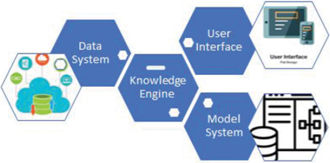
To do this, the essential elements that a DSS [35] must have are (Figure 1):
•a database capable of managing geo-referenced data (Data System and Knowledge Engine);
•a mathematical model that simulates decision-making processes (Model System);
•a graphical interface that assists both the user and the decision-maker (User Interface).
Figure 1. Generic architecture for a DSS
Up to date, the primary goal for a general DSS architecture (its essential components and functionalities) in the domain of ITS and internet of things (IoT) consist in capturing an incoming event to cope with and its effects on the transport systems to account for the communication between the various stakeholders; facilitate the state of alert; access archived and updated data; reveal and update the system status; possess quantitative and qualitative measures to evaluate the choice also providing information or routing solutions. Even-thought several proposals have been developed in the literature [36-38], volunteered geographic information (VGI), ICT and data stream as well as communication and coordination among different data protocols and decision-makers still represent an open questions and the present work wants to provide a debate on it.
The following paragraph offers an overview of some developed DSS tools and transportation models applied to evacuation problems. It focuses on architecture, components and analysis techniques usually applied. Thus covering the evolution of some of the prevalent DSSs, transport network models integrated as sub-model into the simulations process (model system) and emergency management solutions applied to mitigate risk.
Starting from the preliminary architecture presented in Figure 1. Tables 1 and 2 highlight some tools and full DSS developed differentiating them from the input/output layer, and modules integrated.
Table 1. Traditional tools and DSS classification
|
Reference |
[Input]/[Output] |
Model system |
User interface |
Database & ITS funct. |
Disaster type |
Info supply |
|
NETVACl [39] |
[AZ, CD, D] |
Macro |
Analytic |
Static |
Generic |
- |
|
|
[ET, RC, TF] |
|
DM |
- |
|
|
|
ClEAR [40] |
[AZ, H, TD, CD] |
Macro |
Analytic |
Static |
Nuclear |
EP |
|
|
[ET, EE, TF] |
|
DM |
- |
|
|
|
MASSVAC [41] |
[AZ, TD, CD] |
Macro |
Analytic |
Static |
Hurricane |
- |
|
|
[ET, TF, RC] |
|
DM |
- |
|
|
|
IRIMS [42] |
[TD, RN] |
Meso |
Graphic |
Multiple |
Hazard |
- |
|
|
[ET, TF] |
|
DM |
- |
Substance |
|
|
SNEM [43, 44] |
[GIS, TD ND] |
Meso |
Graphic |
Dynamic |
Human |
|
|
|
[ET, TF, RC] |
|
DM |
VMS, AS |
Induced |
|
|
TEDDS [45] |
[AZ, TD, ND] |
Macro |
Graphic |
Disaster |
Generic |
Shelter |
|
|
[ET, TF, RC, PC] |
|
DM |
info |
|
|
|
OREMS [46] |
[GIS, H, TD, RN] |
Meso |
Graphic |
Static |
Hurricane |
- |
|
|
[ET, V, TF] |
|
DM |
- |
|
|
|
CEMPS [47] |
[AZ, DD, TD, ND] |
Micro |
Graphic |
Dynamic |
Human |
EP |
|
|
[ET, RC] |
|
DM |
GIS |
induced |
shelter |
|
Urbanik [48] |
[AZ, H, CD] |
Macro |
Analytic |
Static |
Generic |
- |
|
|
[ET, RC, TF] |
|
DM |
- |
|
|
|
Barret et al. [49] |
[AZ, H, ND, TD, DD] |
Macro |
Graphic |
Dynamic |
Hurricane |
EP |
|
|
[ET, PC, SO] |
|
|
VMS, GPS |
RT |
|
|
EVAC risk [33,50] |
[GIS, AZ, DD, ND] |
Macro |
Graphic |
Static |
- |
EP |
|
|
[V, risk map] |
|
DM |
|
|
|
|
IMDAS [51] |
[TD, RN] |
Micro |
Graphic |
Multiple |
Hurricane |
- |
|
|
[ET, TF] |
|
|
- |
|
|
|
Cova et al. [52] |
[GIS, TD, DD] |
Micro |
Graphic |
Dynamic |
- |
EP |
|
|
[TT, RC] |
|
|
|
|
|
|
Dynasmart [53] |
[AZ, GIS, TD, DD] |
Meso |
Graphic |
Static |
Human |
- |
|
|
[TF, SO, RC] |
|
DM |
- |
Induced |
|
Note: =AZ = area zoning, CD = census data, D = demand, DM = analyst, ET = evacuation time, ET = evacuation/clearance time, EV = evacuee, H = hazard, HB = human behaviour, macro = macroscopic, meso = mesoscopic, micro = microscopic, ND = network data, RC = road capacity, SD = sensors, SO = system optimum, TD = traffic data, TF = traffic flow, TT = travel time, V = vulnerability, VMS = variable message system.
Table 2. Innovative tools and DSS classification
|
Ref. |
[Input]/[Output] |
Model system |
User interface |
Database & ITS funct. |
Disaster type |
Info supply |
|
Mitsimlab [54] |
[TD, ND] |
Micro |
Graphic |
Dynamic |
Man-made |
Route |
|
|
[TF, RC] |
|
|
VMS, AS |
|
|
|
GIERS [56] |
[GIS, H, d-TD] |
Meso |
Graphic |
Real-time |
Human |
Route |
|
|
[ET, TF] |
|
DM, EV |
AS, |
Induced |
|
|
MRAC [57] |
[GIS, TD, D] |
Meso |
Graphic |
Real-time |
Flood |
|
|
|
[ET, TM, SO] |
|
|
Dynamic |
|
|
|
STEMS [58] |
[AZ, TD, ND] |
Macro |
Analytic |
Dynamic |
Flood |
Route |
|
|
[ET, EP] |
|
|
VMS, AS |
|
EP |
|
EVA-Q [59, 60] |
[ND, TD, D] |
Meso |
Analytic |
Dynamic |
Flood |
Route |
|
|
[ET, TF, HB] |
|
|
VMS |
|
Shelter |
|
GIWETES [61] |
[GIS, AZ, TD, ND] |
RM |
Graphic |
Dynamic |
Tsunami |
Flood |
|
|
[V, SO] |
SA |
DM, EV |
VMS, AS |
|
Shelter |
|
DTA [62] |
[GIS, D, ND] |
Meso |
Graphic |
Real-time |
Various |
EP |
|
|
[ET, RC] |
|
|
Various |
|
Route |
|
ICDMS [63] |
[cloud] |
Macro |
Graphic |
Real-time |
Various |
Shelter |
|
|
[ET, RC] |
|
DM, EV |
VGI, AS, V2x |
|
Route |
|
Yu et al. [64] |
[GIS, AZ, TD, ND] |
Micro |
Graphic |
Dynamic |
Man-made |
Route |
|
|
[ET, TF, TT] |
|
|
VMS, AS |
|
Shelter |
|
Schnebele et al. [65] |
[cloud, ND] |
RM |
Graphic |
Real-time |
Flood |
Route |
|
|
[V, RCD] |
SA |
DM |
RSU, VGI, AS |
|
Shelter |
|
GIS-SM [66] |
[GIS, ND, TD] |
RM |
Graphic |
Real-time |
Tsunami |
Route |
|
|
[V] |
SA |
DM, EV |
RSU, VGI, AS |
|
EP |
|
AGORA-DS [67] |
[cloud] |
Macro |
Graphic |
Real-time |
Various |
Speed |
|
|
[ET, HI, V] |
|
DM |
RSU, VGI, AS |
|
Route |
|
Burris et al. [68] |
[ND, TD] |
NICTA |
Graphic |
Real-time |
Hurricane |
Route |
|
|
[TF, ET] |
|
DM |
VMS |
|
Flows |
|
IDSS [69] |
[GIS] |
RM |
Graphic |
Real-time |
Various |
Rescue |
|
|
[RCD, RC, V] |
SA |
DM |
OSM, VGI |
|
Shelter |
|
OFRM [70] |
[Web-dss] |
ORS |
Graphic |
Real-time |
Flood |
CI |
|
|
[AI, CI] |
SA |
DM |
OSM, VGI |
|
Route |
|
EVAC sys [71] |
[ND, TD] |
Meso |
DM, EV |
dynamic |
Flood |
Shelter |
|
|
[ET, TT, RC] |
|
|
RSU, VGI |
|
Route |
|
A-RESCUE [72] |
[GIS, ND] |
Meso |
Graphic |
Dynamic |
Hurricane |
- |
|
|
[ET, TT, PC, HB] |
|
DM |
AS |
|
|
|
IWEDSS [73] |
[Historical, Web] |
Meso |
Graphic |
Dynamic |
Fire |
EP |
|
|
[V, SO] |
|
DM, EV |
VGI, RSU |
|
|
|
MC-SDSS [74] |
[GIS, ND, TD] |
AHP |
Graphic |
Dynamic |
Various |
TNP |
|
|
[V, RC, AI] |
SA |
DM |
AS |
|
|
|
SIPAT [75] |
[GIS, ND] |
AHP |
Graphic |
Dynamic |
Tsunami |
TNP |
|
|
[V, RC, AI] |
SA |
DM |
AS |
|
|
Note: AI = accessibility index, AS = areal sensor, AZ = area zoning, CI= critical infrastructure, D = demand, DM = analyst, EP = emergency planning, EP = evacuation performance, ET = evacuation/clearance time, EV = evacuee, H = hazard, HB = human behaviour, HI = hazard Index, macro = macroscopic, meso = mesoscopic, micro = microscopic, ND = network data, ORS = Open route Service API, RC = road capacity, RCD = road condition damage, RM = risk map, RSU = road-side units, SA = spatial analysis, SD = sensors, SO = system optimum, TD = traffic data, TF = traffic flow, TNP = transport network performance, TT = travel time, V = vulnerability, VMS = variable message system.
As reported in Table 1 first attempt to deal with emergency conditions consisted in the creation of TSM tools where the potential risk area is defined as a prior (emergency planning zone (EPZ)), typical for large-scale evacuations and long-term planning activities. In this, what-if scenario simulations are the basis for emergency preparation and response stages, and the static approach is used for the determination of optimal solutions in case of emergency [39, 40, 46, 48, 54]. Also, the critical cluster model [33], or the solution offered in [50, 55], even if integrated with geo-referred data and the TSM models, do not cope with real-time data nor possess a communication system with external sensors and collaborative systems. It emerges how these systems are thought for what-if scenarios and to analyse past events. Thus a significant limitation for many of these modules is their static nature; the impossibility of interfacing these with a real-time data source or exchanging information with external servers; even more, they do not let to perform behavioural aspects for the evacuees.
To date, new technologies enabled the possibility of introducing a DSS capable of combining the mathematical model, the spatial component and the information technology (through information standardization and real-time data activity). The current wide impulse of such applications brought researchers and analysts to review the opportunities and drawbacks of the information domain [76-78]. Thus valuing new sources and repositories connected with big data [79], open data as Open Street Map (OSM) [80-82] and collaborative systems [83-85]. As an example, the role of collaborative systems integrated in GIS environment is at the basis of the Open Flood Risk Map (OFRM) system [86, 87]. It integrates all modules of DSS, and the solution for the route service, according to various criteria, may be visualized utilizing graphical output. Anyway, it is not possible to inform evacuees directly via mobile.
So far, we focused our synopsis on the architecture associated with DSS and the simulation processes carried out by the analysis sub-models. Many DSS have been developed to respond to specific needs anyway since disasters can generally trigger side effects; this limitation tends to have a substantial impact on the effectiveness. Moreover, it has been evident that many of the models developed so far have a more empirical or evaluation nature. Although included among the DSS, they perform a more qualitative and informative task on disasters without providing a practical tool capable of supporting the decision-maker in real-time situations and response analysis. Moreover, information technology and open standard are, till today, novel frontiers into EDM activities [24].
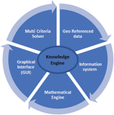
Figure 2. Essential sub-models into novel DSS
Thus, the current survey has shown the essential cornerstones in a SDSS: the knowledge engine that is the core of the system, the information system (database) with access to internal and external data and information; the model system tool for simulation and analyses that may comprise different criteria and groups of decision-makers, the graphical interface for reports and graphics for quick and intuitive control of the process and a delivery system. Thus as a further specification of the general architecture presented in Figure 1, the main modules that, in our opinion, a SDSS should possess are reported in Figure 2.
4.1 Proposal and general architecture
As stated, novel DSSs should assist decision-makers in all phases of the emergency; this implies a complex and recursive workflow, and in it, the integration of different sub-models will result in a general system based on a geo-computerized environment. This kind of DSS will result in a composition of blocks and servers, comprised of databases and repositories equipped with external sensors, internal geo-database and the simulation matching system feeding their data, as well a graphical and video interface to visualize the information and configure the decision support information.
The main features are as follows:
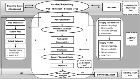
Monitoring: the system should provide information on current external conditions both utilizing areal and remote sensors, roadside units and information from citizens, who freely choose to collaborate.
Archive/repository: a GIS repository to archive past events, their effects and adopted solutions as well as ordinary traffic conditions.
Hazard: the DSS should be able to deal with different phenomena, the preventive introduction to a different class of problems enables the user repositories and alert the proper decision-makers teams to collaborate.
Perturbation: a simulation sub-models that take information from the repository and analyse past emergencies, introducing information about potential effects and losses with current traffic conditions under a pre-ordered plan.
Potential Damages: these sub-modules communicate with the perturbation module and cope with geographical and time effects to simulate the area interested by the incoming phenomenon. The same also lets the analyst to know people displacement and critical infrastructures.
Scenario: this module evaluates potential damages from the previous step and sent charge all the information to the decision-makers to evaluate strategies, accounting on available resources.
Strategies: it represents the core of the scenery level, it is equipped with a TSM and interfaced with the assignment model to evaluate exposure for each strategy, also letting separate groups of analysts to work on their specific task as a result for this sub-module the decision-makers obtain exposure indexes, the same will be passed to the MCA solver to evaluate if strategies can be feasible or not.
Multi-criteria analysis: As output for the scenario level, the decision-maker choose the most performing solution or a set of possible alternative and sends information to citizens and rescuers if no exposure level result is acceptable, the process is iterated to evaluate new strategies on an updated set of data.
Communication: an information layer lets to send information from frontiers and online respondents to integrate early warnings and instructions. The same should also enable the collaborative function for the monitoring phase. The system requires an online communication protocol to be fixed not to overcome bias or errors; all the data gathered by nonexperts will be matched with data from police and expert users to let analysts filter outliers, as a matter of fact filtering non authoritative suppliers it’s a preliminary operation.
In Figure 3, the structure of the proposed DSS, pointing out the inter-dependencies for such a complex system is reported.
Resuming at the basis of our concept, we have a Repository level that based on an external communication from sensors and collaborative sources both form authoritative non and an archive of past events and damage occurred; a layout level both integrated with a solver that operates on an ongoing and updated scenario level. Under the assumption that different decision-makers will collaborate on the same emergency for each one of them a Task section will be created to contribute to the solution.
The possibility to work on dynamic scenarios and real-time, also involving rescuers and evacuees through the communication systems, data will enable the possibility for the statistical analysis between the forecasted and the experienced behaviour. The comparison of the forecasted vs experienced data will be carried out utilizing statistical analysis to verify the capacity of the TSM to simulate destination and route choice during a ‘real’ evacuation. This further validation will be part of the process to help municipalities to draw up efficient planning solutions during different kinds of emergencies.
Figure 3. Blocks of the proposed DSS
4.2 Discussion
In emergency conditions, road safety requires the study of numerous variables, often characterized by high uncertainty. Thus, transport must be rethought as an integrated and dynamic system in which information management and control operate simultaneously to optimize mobility in line with the ITS introduction by Directive 2010/40/EU. The introduction of long and short-range sensors (even not explicitly designed to evaluate road conditions and control), floating car data and satellites will enable intelligent traffic management. Thus, analysts can use dynamic lane solutions to increase capacity and operational reliability, suggesting speed, modifying density pro lane, rerouting evacuees and delaying platoons, thus minimizing the economic and environmental impacts.
The integration of open data and multiple sources of information, including VGI and nonauthoritative data, offers the opportunity to know evacuees’ locations and the local conditions of the infrastructures. Furthermore, the information flow through mobile devices and web applications let the administrations increase the evacuees’ consciousness and let them know what to do (e.g., which destination to reach, which path to undertake), modifying evacuees’ performance concerning a pre-ordered plan or scenario without ICT.
Nowadays, most mobile users have an active broadband subscription and might be able to send messages and perform tasks, such as sourcing in creating real-time disaster-info-map. The validation process will follow the so-called crowd-sourcing validation techniques and the occurrence of the same pattern in the stream to verify the quality of the information. Anyway, volunteers are not necessarily experts and so produce nonspecific information causing poor quality or false information connected to data gathering protocols, thus affecting also the interpretation of the monitor system. By this way maybe the recourse to artificial intelligence instead of a subjective perspective might reduce misinterpretation.
Risk management in emergency conditions involves the mobilization of people and vehicles; thus these scenarios are not comparable with normal flow conditions. The objective in limiting the societal risk may imply the reduction of evacuation times, the elimination of queue phenomena, the rationalization of costs and resources to be used. Depending on the nature of the event; the lack of capacity would be endogenous or exogenous and it is evident that static approaches or the simulation of preordained scenarios do not fully capture the real dynamics linked to these critical phenomena. Thus, to improve resilience and maintain active the supply chains, public administrators have chosen to adopt DSS as an instrument to manage emergencies. Providing these services requires that adequate prevention measures and actions are taken upstream also in the planning process, taking into account the possible network crisis and considering mobility alternatives both in terms of path and modal choice. This paper highlighted the strengths and drawbacks of the developed SDSS and their application into EDM; it focused on the opportunity to create a mobile collaborative system whose structure is composed of three main layers based on advanced information, communication and traditional TSM simulation tools. The collaborative collecting system, interfaced with a GIS, lets the analysts have a more comprehensive knowledge of the environment, the critical infrastructures and the road network conditions. The scenery level fed by the repository level and in connection with the mathematical solver lets the system to evaluate step by step the ongoing process. The communication systems interfacing with mobile devices help to know the exact locations of rescuers and evacuees. Moreover, the idea to develop a more general structure which not focus on pre-ordered conditions or fixed disaster types will introduce the possibility of customizing the DSS for different municipalities. The opportunity to develop such a tool resides in the possibility to enhance a unique platform for different stakeholders who choose in a participatory manner to share ordinary information embracing the concept of a smart city.
From the citizens’ perspective, the ICT system gives positive economic impacts to the community by reducing risk and increasing social knowledge, with no additional costs. Moreover, the system will provide public administration with the possibility to organize several trials with the social associations, using the ICT system as reference managing. The data obtained by testing experiences are beneficial for calculating statistics and forecasting through regressive statistical models better to organize the functioning of systems for subsequent emergencies. limitations to the collaborative system approach might be caused by bias on the suppliers, no coverage in the area or simply users might be involved in other activities and panic. Moreover, it is unclear which could be the case by case the statistical coverage that will get the significance on hazard and an on-route path dynamic map; anyway, the complexity of these questions overcomes the present goal.
Data presented in the study are included in the paper. Further inquiries can be directed to the corresponding author.
[1] Russo, F., Rindone, C. (2011). The planning process and logical framework approach in road evacuation: A coherent vision. WIT Transactions on the Built Environment, 117: 415-425. https://doi.org/10.2495/SAFE110361
[2] Van Raemdonck, K., Macharis, C., Mairesse, O. (2013). Risk analysis system for the transport of hazardous materials. Journal of Safety Research, 45: 55-63. http://dx.doi.org/10.1016/j.jsr.2013.01.002
[3] Russo, F., Rindone, C. (2014). Urban exposure: training activities and risk reduction. WIT Transactions on Ecology and the Environment, 191: 991-1001. http://dx.doi.org/10.2495/SC140842
[4] Russo, F., Vitetta, A. (2006). Risk evaluation in a transportation system. International Journal of Sustainable Development and Planning, 1(2): 170-191. http://dx.doi.org/10.2495/SDP-V1-N2-170-191
[5] Russo, F., Vitetta, A. (2005). Risk in anthropic environments: methodologies for risk evaluation and exposition reduction. WIT Transactions on Biomedicine and Health, 9: 31-45. http://dx.doi.org/10.2495/EHR050041
[6] Russo, F., Chilà, G. (2021). Risk reduction in transport system in emergency conditions: A framework for demand analysis. WIT Transactions on The Built Environment, 206: 255-266. https://doi.org/10.2495/SAFE210211
[7] Rindone, C., Panuccio, P. (2021). Risk reduction in transport system in emergency conditions: A framework for evacuation planning. WIT Transactions on The Built Environment, 206: 285-297. https://doi.org/10.2495/SAFE210241
[8] Musolino, G. (2021). Risk reduction in transport system in emergency conditions: A framework for supply analysis. WIT Transactions on The Built Environment, 206: 275-284. https://doi.org/10.2495/SAFE210231
[9] Vitetta, A. (2021). Risk reduction in transport system in emergency conditions: A framework for network design problems. Safety and Security Engineering IX, 206, 267. https://doi.org/10.2495/SAFE210221
[10] Russo, F., Rindone, C. (2007). Safety of users in road evacuation: Planning internal processes and guidelines. WIT Transactions on the Built Environment, 96: 825-834. https://doi.org/10.2495/UT070781
[11] Wei, H., Zeng, Q.A., Hu, H., Wang, X., Kukreti, A.R. (2008). Integrated urban evacuation planning framework for responding to human-caused disasters over a surface transportation network. Transportation Research Record, 2041(1): 29-37. https://doi.org/10.3141/2041-04
[12] Chen, X., Kwan, M. P., Li, Q., Chen, J. (2012). A model for evacuation risk assessment with consideration of pre- and post-disaster factors. Computers, Environment and Urban Systems, 36(3): 207-217. http://dx.doi.org/10.1016/j.compenvurbsys.2011.11.002
[13] Chakraborty, J., Tobin, G.A., Montz, B.E. (2005). Population evacuation: assessing spatial variability in geophysical risk and social vulnerability to natural hazards. Natural Hazards Review, 6(1): 23-33. http://dx.doi.org/10.1061/(ASCE)1527-6988(2005)6:1(23)
[14] McGhee, C.C., Grimes, M.C. (2006). An operational analysis of the Hampton roads hurricane evacuation traffic control plan. Technical report, Virginia Transportation Research Council.
[15] Chang, M.S., Tseng, Y.L., Chen, J.W. (2007). A scenario planning approach for the flood emergency logistics preparation problem under uncertainty. Transportation Research Part E: Logistics and Transportation Review, 43(6): 737-754. http://dx.doi.org/10.1016/j.tre.2006.10.013
[16] Di Gangi, M. (2009). Safety of users in road evacuation: modelling and DSS for pedestrian outflow. WIT Transactions on Ecology and the Environment, 120: 497-508. http://dx.doi.org/10.2495/SDP090461
[17] Di Gangi, M., Polimeni, A. (2017). A mesoscopic approach to model route choice in emergency conditions. Optimization and Decision Science: Methodologies and Applications: 547-555. http://dx.doi.org/10.1007/978-3-319-67308-0_55
[18] Di Gangi, M., Watling, D., Di Salvo, R. (2020). Modeling evacuation risk using a stochastic process formulation of mesoscopic dynamic network loading. IEEE Transactions on Intelligent Transportation Systems. 23(4): 3613-3625. http://dx.doi.org/10.1109/TITS.2020.3038478
[19] Chilà, G., Musolino, G., Polimeni, A., Rindone, C., Russo, F., Vitetta, A. (2016). Transport models and intelligent transportation system to support urban evacuation planning process. IET Intelligent Transport Systems, 10(4): 279-286. https://doi.org/10.1049/iet-its.2015.0127
[20] Russo, F., Chilà, G. (2010). Dynamic approaches to demand model in evacuation conditions. WIT Transactions on The Built Environment, 111: 303-312. https://doi.org/10.2495/UT100271
[21] Vitetta, A. (2022). Network design problem for risk reduction in transport system: A models specification. International Journal of Transport Development and Integration, 6(3): 283-297. https://doi.org/10.2495/TDI-V6-N3-283-297
[22] Musolino, G. (to be published). Emerging ICT for transport networks in emergency conditions. International Journal of Transport Development and Integration.
[23] Rindone, C., Panuccio, P. (to be published). Planning for risk reduction in the transport system at urban level. International Journal of Transport Development and Integration.
[24] Di Gangi, M., Belcore, O.M. (2021). Risk reduction in transport system in emergency conditions: A framework for decision support systems. WIT Transactions on The Built Environment, 206: 299-311. https://doi.org/10.2495/SAFE210251
[25] Gwynne, S., Galea, E., Owen, M., Lawrence, P.J., Filippidis, L. (1999). A review of the methodologies used in evacuation modelling. Fire and Materials, 23(6): 383-388. http://dx.doi.org/10.1002/(SICI)1099-1018(199911/12)23:6%3C383::AID-FAM715%3E3.0.CO;2-2
[26] Vorst, H.C. (2010). Evacuation models and disaster psychology. Procedia Engineering, 3: 15-21. http://dx.doi.org/10.1016/j.proeng.2010.07.004
[27] Aguirre, B.E., El-Tawil, S., Best, E., Gill, K.B., Fedorov, V. (2015). Contributions of social science to agent-based models of building evacuation. Journal of the Academy of Social Sciences, 6(3): 415-432. https://doi.org/10.1080/21582041.2011.609380
[28] Kasereka, S., Kasoro, N., Kyamakya, K., Goufo, E.F.D., Chokki, A.P., Yengo, M.V. (2018). Agent-based modelling and simulation for evacuation of people from a building in case of fire. Procedia Computer Science, 130: 10-17. https://doi.org/10.1016/j.procs.2018.04.006
[29] Altay, N., Green III, W.G. (2006). OR/MS research in disaster operations management. European Journal of Operational Research, 175(1): 475-493. https://doi.org/10.1016/j.ejor.2005.05.016
[30] Galindo, G., Batta, R. (2013). Review of recent developments in OR/MS research in disaster operations management. European Journal of Operational Research, 230(2): 201-211. https://doi.org/10.1016/j.ejor.2013.01.039
[31] Vizecky, K., El-Gayar, O. (2011). Increasing research relevance in DSS: Looking forward by reflecting on 40 years of progress. In 2011 44th Hawaii International Conference on System Sciences, Kauai, HI, USA: 1-9. https://doi.org/10.1109/HICSS.2011.239
[32] Sugumaran, V., Sugumaran, R. (2007). Web-based spatial decision support systems (WebSDSS): Evolution, architecture, examples and challenges. Communications of the Association for Information Systems, 19(1): 40. https://doi.org/10.17705/1CAIS.01940
[33] Cova, T.J., Church, R.L. (1997). Modelling community evacuation vulnerability using GIS. International Journal of Geographical Information Science, 11(8): 763-784. https://doi.org/10.1080/136588197242077
[34] Wallace, W.A., De Balogh, F. (1985). Decision support systems for disaster management. Public Administration Review, 45: 134-146. https://doi.org/10.2307/3135008
[35] Densham, P.J., Goodchild, M.F. (1989). Spatial decision support systems: A research agenda. In GIS/LIS ‘89. Proc. Annual Conference, Orlando: 707-716.
[36] Othman, S.H., Beydoun, G. (2010). Metamodelling approach towards a disaster management decision support system. In International Conference on Artificial Intelligence and Soft Computing, Zakopane, Poland: 614-621. https://doi.org/10.1007/978-3-642-13232-2_75
[37] Kondaveti, R., Ganz, A. (2009). Decision support system for resource allocation in disaster management. In 2009 Annual International Conference of the IEEE Engineering in Medicine and Biology Society, Minneapolis, MN, USA: 3425-3428. http://dx.doi.org/10.1109/IEMBS.2009.5332498
[38] Blaschke, T., Schmidt, D. (2006). Emapboard: from a collaborative situation mapping environment to a disaster management decision support system. In InterCarto-InterGIS, Berlin: 242-251.
[39] Sheffi, Y., Mahmassani, H., Powell, W.B. (1982). A transportation network evacuation model. Transportation Research Part A: General, 16(3): 209-218. http://dx.doi.org/10.1016/0191-2607(82)90022-X
[40] Mclean, M.A., Moeller, M., Desrosiers, A. (1983). Clear: a model for the calculation of evacuation-time estimates in emergency planning zones. Technical Report, Pacific Northwest Lab.
[41] Hobeika, A.G., Jamei, B, (1985). MASSVAC: A model for calculating evacuation times under natural disasters. Emergency Planning.
[42] Peckham, R., Haastrup, P., Otway, H. (1988). A computer-based system for risk management support. Decision Support Systems, 4(4): 481-489. http://dx.doi.org/10.1016/0167-9236(88)90011-5
[43] Stern, E., Sinuany-Stern, Z. (1989). A behavioural-based simulation model for urban evacuation. Papers of the Regional Science Association, 66: 87-103. http://dx.doi.org/10.1007/BF01954298
[44] Sinuany-Stern, Z., Stern, E. (1993). Simulating the evacuation of a small city: The effects of traffic factors. Socio-Economic Planning Sciences, 27(2): 97-108. http://dx.doi.org/10.1016/0038-0121(93)90010-G
[45] Hobeika, A.G., Kim, S., Beckwith, R.E. (1994). A decision support system for developing evacuation plans around nuclear power stations. Interfaces, 24(5): 22-35. http://dx.doi.org/10.1287/inte.24.5.22
[46] Tufekci, S. (1995). An integrated emergency management decision support system for hurricane emergencies. Safety Science, 20(1): 39-48. http://dx.doi.org/10.1016/0925-7535(94)00065-B
[47] Pidd, M., Eglese, R., de Silva, F.N. (1996). CEMPS: A prototype spatial decision support system to aid in planning emergency evacuations. Transactions in GIS, 1(4): 321-334. http://dx.doi.org/10.1111/j.1467-9671.1996.tb00054.x
[48] Urbanik II, T. (2000). Evacuation time estimates for nuclear power plants. Journal of Hazardous Materials, 75(2-3): 165-180. http://dx.doi.org/10.1016/S0304-3894(00)00178-3
[49] Barrett, B., Ran, B., Pillai, R. (2000). Developing a dynamic traffic management modeling framework for hurricane evacuation. Transportation Research Record, 1733(1): 115-121. http://dx.doi.org/10.3141/1733-15
[50] Church, R.L., Cova, T.J. (2000). Mapping evacuation risk on transportation networks using a spatial optimization model. Transportation Research Part C: Emerging Technologies, 8(1-6): 321-336. http://dx.doi.org/10.1016/S0968-090X(00)00019-X
[51] Franzese, O. (2001). Traffic modeling framework for hurricane evacuation. In Proceedings of 80th Annual Meeting of TRB, Washington, DC.
[52] Cova, T.J., Johnson, J.P. (2002). Microsimulation of neighborhood evacuations in the urban-wildland interface. Environment and Planning A, 34(12): 2211-2229. http://dx.doi.org/10.1068/a34251
[53] Kwon, E., Pitt, S. (2005). Evaluation of emergency evacuation strategies for downtown event traffic using a dynamic network model. Transportation Research Record, 1922(1): 149-155. http://dx.doi.org/10.1177/0361198105192200119
[54] Jha, M., Moore, K., Pashaie, B. (2004). Emergency evacuation planning with microscopic traffic simulation. Transportation Research Record, 1886(1): 40-48. http://dx.doi.org/10.3141/1886-06
[55] Sbayti, H., Mahmassani, H.S. (2006). Optimal scheduling of evacuation operations. Transportation Research Record, 1964(1): 238-246. http://dx.doi.org/10.1177/0361198106196400126
[56] Kwan, M.P., Lee, J. (2005). Emergency response after 9/11: the potential of real-time 3D GIS for quick emergency response in micro-spatial environments. Computers, Environment and Urban Systems, 29(2): 93-113. http://dx.doi.org/10.1016/j.compenvurbsys.2003.08.002
[57] Liu, H.X., Ban, J.X., Ma, W., Mirchandani, P.B. (2007). Model reference adaptive control framework for real-time traffic management under emergency evacuation. Journal of Urban Planning and Development, 133(1): 43-50. http://dx.doi.org/10.1061/(ASCE)0733-9488(2007)133:1(43)
[58] Hamza-Lup, G.L., Hua, K.A., Le, M., Peng, R. (2008). Dynamic plan generation and real-time management techniques for traffic evacuation. IEEE Transactions on Intelligent Transportation Systems, 9(4): 615-624. http://dx.doi.org/10.1109/TITS.2008.2006738
[59] Pel, A.J., Bliemer, M.C., Hoogendoorn, S.P. (2008). EVAQ: A new analytical model for voluntary and mandatory evacuation strategies on time-varying networks. In 2008 11th International IEEE Conference on Intelligent Transportation Systems, IEEE, Beijing, China: 528-533. http://dx.doi.org/10.1109/ITSC.2008.4732655
[60] Pel, A.J., Hoogendoorn, S.P., Bliemer, M.C. (2010). Evacuation modeling including traveler information and compliance behavior. Procedia Engineering, 3: 101-111. http://dx.doi.org/10.1016/j.proeng.2010.07.011
[61] Steinmetz, T., Raape, U., Teßmann, S., Strobl, C., Friedemann, M., Kukofka, T., Riedlinger, T., Mikusch, E., Dech, S. (2010). Tsunami early warning and decision support. Natural Hazards and Earth System Sciences, 10(9): 1839-1850. http://dx.doi.org/10.5194/nhess-10-1839-2010
[62] Ayfadopoulou, G., Stamos, I., Mitsakis, E., Grau, J.M.S. (2012). Dynamic traffic assignment based evacuation planning for CBD areas. Procedia - Social and Behavioral Sciences, 48: 1078-1087. http://dx.doi.org/10.1016/j.sbspro.2012.06.1084
[63] Alazawi, Z., Altowaijri, S., Mehmood, R., Abdljabar, M.B. (2011). Intelligent disaster management system based on cloud-enabled vehicular networks. In 2011 11th International Conference on ITS Telecommunications, Petersburg, Russia, pp. 361-368. http://dx.doi.org/10.1109/ITST.2011.6060083
[64] Yu, J., Pande, A., Nezamuddin, N., Dixit, V., Edwards, F. (2014). Routing strategies for emergency management decision support systems during evacuation. Journal of Transportation Safety & Security, 6(3): 257-273.
[65] Schnebele, E., Cervone, G., Waters, N. (2014). Road assessment after flood events using non-authoritative data. Natural Hazards and Earth System Sciences, 14(4): 1007-1015.
[66] Ai, F., Comfort, L.K., Dong, Y., Znati, T. (2016). A dynamic decision support system based on geographical information and mobile social networks: A model for tsunami risk mitigation in Padang, Indonesia. Safety Science, 90: 62-74. http://dx.doi.org/10.1016/j.ssci.2015.09.022
[67] Horita, F.E., de Albuquerque, J.P., Degrossi, L.C., Mendiondo, E.M., Ueyama, J. (2015). Development of a spatial decision support system for flood risk management in Brazil that combines volunteered geographic information with wireless sensor networks. Computers & Geosciences, 80: 84-94. http://dx.doi.org/10.1016/j.cageo.2015.04.001
[68] Burris, J.W., Shrestha, R., Gautam, B., Bista, B. (2015). Machine learning for the activation of contraflows during hurricane evacuation. 2015 IEEE Global Humanitarian Technology Conference, Seattle, WA, USA, pp. 254-258. http://dx.doi.org/10.1109/GHTC.2015.7343981
[69] Rajabifard, A., Thompson, R.G., Chen, Y. (2015). An intelligent disaster decision support system for increasing the sustainability of transport networks. Natural Resources Forum, Wiley Online Library, 39(2): 83-96. http://dx.doi.org/10.1111/1477-8947.12070
[70] Eckle, M., de Albuquerque, J.P., Herfort, B., Zipf, A., Leiner, R., Wolff, R., Jacobs, C. (2016). Leveraging OpenStreetMap to support flood risk management in municipalities: A prototype decision support system. In Proceedings of the ISCRAM 2016 Conference – Rio de Janeiro, Brazil.
[71] Khalid, O., Khan, M.U.S., Huang, Y., Khan, S.U., Zomaya, A. (2016). EVACSYS: a cloud-based service for emergency evacuation. IEEE Cloud Computing, 3(1): 60-68. http://dx.doi.org/10.1109/MCC.2016.10
[72] Ukkusuri, S.V., Hasan, S., Luong, B., Doan, K., Zhan, X., Murray-Tuite, P., Yin, W. (2017). A-rescue: An agent-based regional evacuation simulator coupled with user enriched behavior. Networks and Spatial Economics, 17(1): 197-223. http://dx.doi.org/10.1007/s11067-016-9323-0
[73] Nara, A., Yang, X., Machiani, S.G., Tsou, M.H. (2017). An integrated evacuation decision support system framework with social perception analysis and dynamic population estimation. International Journal of Disaster Risk Reduction, 25: 190-201. http://dx.doi.org/10.1016/j.ijdrr.2017.09.020
[74] Ghavami, S.M. (2019). Multi-criteria spatial decision support system for identifying strategic roads in disaster situations. International Journal of Critical Infrastructure Protection, 24: 23-36. http://dx.doi.org/10.1016/j.ijcip.2018.10.004
[75] Catalan, P.A., Gubler, A., Cañas, J., Zuñiga, C., Zelaya, C., Pizarro, L., Valdes, C., Mena, R., Toledo, E., Cienfuegos, R. (2020). Design and operational implementation of the integrated tsunami forecast and warning system in Chile (SIPAT). Coastal Engineering Journal, 62(3): 373-388. http://dx.doi.org/10.1080/21664250.2020.1727402
[76] Zerger, A., Smith, D.I. (2003). Impediments to using GIS for real-time disaster decision support. Computers, Environment and Urban Systems, 27(2): 123-141. http://dx.doi.org/10.1016/S0198-9715(01)00021-7
[77] El-Heishy, S.S., Saleh, A.A., Asem, A. (2012). Managing evacuation process in urban areas using a GIS system: A case study on Mansoura city. International Journal of Computer Applications, 57(10): 38-42. http://dx.doi.org/10.5120/9154-3407
[78] Abdalla, R., Esmail, M. (2018). WebGIS for disaster management and emergency response. Springer.
[79] Akter, S., Wamba, S.F. (2019). Big data and disaster management: a systematic review and agenda for future research. Annals of Operations Research, 283(1-2): 939-959. http://dx.doi.org/10.1007/s10479-017-2584-2
[80] Zhang, C., Li, W. (2005). The roles of web feature and web map services in real-time geospatial data sharing for time-critical applications. Cartography and Geographic Information Science, 32(4): 269-283. http://dx.doi.org/10.1559/152304005775194728
[81] Haklay, M., Weber, P. (2008). OpenStreetMap: user-generated street maps. IEEE Pervasive Computing, 7(4): 12-18. http://dx.doi.org/10.1109/MPRV.2008.80
[82] Neis, P., Zielstra, D. (2014). Recent developments and future trends in volunteered geographic information research: The case of openstreetmap. Future Internet, 6(1): 76-106. http://dx.doi.org/10.3390/fi6010076
[83] Goodchild, M.F. (2007). Citizens as sensors: the world of volunteered geography. GeoJournal, 69(4): 211-221. http://dx.doi.org/10.1007/s10708-007-9111-y
[84] Horita, F.E.A., Degrossi, L.C., de Assis, L.F.G., Zipf, A., de Albuquerque, J.P. (2013). The use of volunteered geographic information (VGI) and crowdsourcing in disaster management: A systematic literature review. In Proceedings of the Nineteenth Americas Conference on Information Systems, Chicago, Illinois.
[85] Luna, S., Pennock, M. (2015). Social media in emergency management advances, challenges and future directions. In 2015 Annual IEEE Systems Conference (SysCon) Proceedings, Vancouver, BC, Canada, pp. 792-797. http://dx.doi.org/10.1109/SYSCON.2015.7116847
[86] Neis, P., Singler, P., Zipf, A. (2010). Collaborative mapping and emergency routing for disaster logistics - case studies from the Haiti earthquake and the UN Portal for Afrika. Geoinformatics Forum Salzburg, pp. 239-248.
[87] Neis, P., Zipf, A. (2012). Analyzing the contributor activity of a volunteered geographic information project - the case of openstreetmap. ISPRS International Journal of Geo-Information, 1(2): 146-165. http://dx.doi.org/10.3390/ijgi1020146