Fernando Morante-Carballo![]() | Brayan Pinto-Ponce
| Brayan Pinto-Ponce![]() | Eduardo Santos-Baquerizo
| Eduardo Santos-Baquerizo![]() | Josué Briones-Bitar
| Josué Briones-Bitar![]() | Edgar Berrezueta
| Edgar Berrezueta![]() | Paúl Carrión-Mero*
| Paúl Carrión-Mero*![]()
© 2024 The authors. This article is published by IIETA and is licensed under the CC BY 4.0 license (http://creativecommons.org/licenses/by/4.0/).
OPEN ACCESS
The threat of earthquakes is a constant reality in coastal areas that make up the circumpacific belt. These areas present a high tectonic activity and, therefore, a predisposition to the occurrence of earthquakes. However, structural vulnerabilities generate an imminent risk for local and structural populations. The study aims to analyze the experiences and adaptations of initiatives related to seismic construction in the Pacific Ring of Fire regions using a bibliometric approach and a systematic review. It focuses on the identification of mitigation plans and regulations to reduce seismic risk in vulnerable areas, as well as to evaluate the impact on construction processes. The methodology consists of 3 phases: I) sample selection based on SCOPUS data, II) statistical analysis of the metrics referring to the publications using Vosviewer software, and III) systematic literature review and implications for earthquake preparedness. The study results include compiling plans and regulations to mitigate seismic risk and highlighting their relevance for future research and the advancement of practices aligned with the Sustainable Development Goals (SDGs), particularly SDG 11 (Sustainable Cities and Communities). These contributions are of great value to engineering and urban planning, providing a basis for improving seismic resilience in the highest-risk areas.
seismic accelerations, fire belt, building codes, earthquakes, mitigation and structural damage
Earthquakes are caused by movement between plates along a tectonic fault, releasing stored strain energy through mechanical motion and seismic waves [1]. These occur within and around tectonic plate boundaries and due to volcanic activity. Earthquakes cause significant damage to structures and buildings and have caused 71,950 human losses and $43,705 million in losses to the global economy between 2000-2021 [2]. The earthquake with the most significant magnitude recorded to date is the one that occurred in 1960, in the coastal city of Valparaíso in Chile, with 9.5, This event caused a tectonic subsidence of more than 1.5 meters, resulting in more than 2000 deaths and severe damage to civil works.
From the mid-nineteenth century to the early twentieth century, countries worldwide implemented a policy of greater stringency by applying building codes. Countries such as Chile and Japan stand out for their rigidity in applying building regulations due to their high seismic vulnerability [3]. Chile sits in a region where the tectonic plates of South America and the Nazca plate converge, while Japan borders the Pacific, Philippine and Eurasian plates, which have originated high-magnitude earthquakes throughout its history. An example is the 2011 Japan tsunami with a magnitude of 9.1 Mw [4].
The countries located in the Pacific Ocean Ring of Fire is a region known for its high seismic susceptibility. The ring of fire, or circum-Pacific belt, is a region of high seismic intensity, which concentrates 85% of the energy released by the planet. In this zone, the tectonic plates move between 3.2 - 12.4 cm/year [5]. The Ring of Fire comprises the boundaries of the coastal zones of the following continents: Oceania, Asia and America; made up of 27 countries (3 from North America, 7 from Central America, 6 from South America, 7 from Asia and 4 from Oceania). The 10 strongest earthquakes of the previous century have been recorded in the circum-Pacific belt (Valdivia, Chile (1960); Alaska (1964); Sumatra, Indonesia (2004); Japan (2011); Kamchatka, Russia (1952); BioBio, Chile (2010); Ambato, Ecuador (1906); Kunashir, Russia (1950); Assam, Tibet (1950); Vallenar, Chile (1922)), this region is of high seismic vulnerability therefore it is necessary to include mitigation plans and technical criteria by experts.
The threat of earthquakes requires mitigation techniques. Seismic risk management encompasses preventive and corrective measures to reduce hazard and vulnerability. Among the primary methods are seismic isolators, passive energy dissipaters, and semi-active, active and hybrid control systems, widely used to minimize damage to infrastructure during an earthquake [6]. However, other technical methods contribute innovative research that helps develop disaster prevention.
Risk refers to potential losses caused by natural phenomena resulting from the vulnerability of the exposed elements. It arises from hazard and vulnerability and is especially serious in developing countries. An example is the 7 Mw earthquake in Haiti in 2010, which caused more than 200,000 deaths and US$ 8.1 billion in losses due to lack of preparedness and informal constructions. For this reason, the rigorous application of construction regulations is necessary to ensure seismic safety and response [7].
Building codes guide designing resistant structures, ensuring the structural capacity of buildings. Governments and construction-related sectors establish design requirements in building codes and update these standards [8]. Government authorities are responsible for enforcing these standards through reviews of minimum constructive compliances, verifying the following: current state of the infrastructure, operating and design time, quality of construction materials and concrete strength, soil properties, condition and dimensions of the elements, minimum requirements necessary for the maintenance of any particular structural element, below in Table 1, the construction standards used by some countries in the fire belt region appear. In this way, they reduce the risks produced by the degree of seismicity, guaranteeing structural stability and extending the design time.
Table 1. Construction regulations in the regions of the fire belt
|
Regions |
Countries |
Details of the Codes |
Codes |
Sources |
|
America |
USA |
Detailed and state-specific building codes. - Anti-seismic standards in earthquake-prone areas. - Hurricane regulations in coastal areas. |
International Building Code, IBC |
[9] |
|
Canada |
National building codes including standards for snow and cold resistance. - Earthquake regulations in some regions. |
National Building Code of Canada, NBCC |
[10] |
|
|
Chile |
Rigid seismic regulations due to high seismic activity. - Resilience efforts in reconstruction after natural disa8st ers. |
NCh433 |
[11] |
|
|
Mexico |
Minimum structural safety and earthquake safety requirements for design and construction, seismic hazard assessment, selection of seismically resistant materials. |
NOM-001.SEDE-2012, NOM-002-SEDE-2010, NTCDS-2017, NMX |
[12] |
|
|
Asiai |
Japan |
Advanced construction standards to withstand earthquakes and tsunamis. Innovative technologies in design, seismic construction. |
(Disaster Prevention Law) / (Building Code) |
[13] |
|
China |
GB 50010-2010: Design and construction of reinforced concrete structures. |
GB 50010-2010 |
[14] |
|
|
Philipinas |
The National Builing Code of the Philipinas covers aspects related to construction, building materials, land use, fire safety and zoning requirements. |
National Building Code of the Philippines, DPWH y NCC |
[15] |
|
|
Oceania |
Australia |
Minimum safety, health and housing requirements for buildings, construction materials and structural safety. |
National Construction Code (NCC) y Building Code of Australia (BCA) |
[16] |
|
New Zealand |
Building regulations, risk management, quality of buildings in the country, design, construction, sustainability, sanitation, energy efficiency, sustainability, fire protection. |
Building Act 2004 y New Zealand Building Code (NZBC) |
[17, 18] |
|
|
New caledonia |
High quality in the design, construction and maintenance of buildings, promotes construction standards that guarantee the safety and sustainability of buildings. |
Code de la construction et de l'habitation (CCH) |
[18] |
|
According to the World Bank, the number of dwellings in the world is 2.3 billion, and some sources indicate that about 1.6 billion people live in inadequate housing. According to the World Bank, this represents 69.56% of substandard (nonconforming) construction worldwide, and nonconforming structures are prevalent in rural and urban areas in all developing countries. These constructions derive from construction methods derived from the personal experience of those who build them. However, these infrastructures are vulnerable to natural hazards and seismic events, which underlines the need for building regulations and their enforcement to ensure adequate seismic response [19].
One way to study mitigation plans due to earthquakes is to review the scientific world using metrics such as bibliometrics. The literature review contributes to the development and advancement of research by providing a method focused on minimizing errors in the selection of studies in specific knowledge sectors, as well as a description of search efforts to identify potential gaps and highlight the limits of information. Bibliometric studies are considered a scientific approach that uses measurable data to describe, inspect, and monitor scientific contributions in a field of science and identify trends.
Some researchers in earth sciences have developed studies in different coastal regions. The article aims to collect data on seismically vulnerable areas over the past thirty-seven years. To prevent large waves (tsunamis) generated by earthquakes from affecting coastal areas, Anawat proposed the creation of structures such as breakwaters, seawalls and sea gates as countermeasures to protect residential dwellings and commercial and public places, Seismic risk management could be the measures taken before and after a destructive earthquake to modify its hazard or vulnerability and better prepare for future foreseeably damaging earthquakes of significant magnitude [20]. These studies have been a valuable contribution to the research, so it is necessary to do a systematic review and a bibliometric analysis to integrate the studies carried out. These investigations provided helpful information on the subject.
The results provided by experts in different research topics resulted in publications by authors around the world, and their information was stored in various databases in research journals to summarize the global trends in research on disaster mitigation or damage due to earthquakes and provide different technical criteria.
Given this, the following research questions present themselves: What are the most effective initiatives implemented in the countries of the Pacific Ring of Fire to improve the seismic resistance of buildings, and how have these initiatives been adapted to the local conditions of each region, what materials and construction techniques have proven to be most effective in mitigating the effects of seismic accelerations, and how is this data incorporated in the design of earthquake-resistant buildings? This research challenge addresses the issue by analyzing scientific publications on earthquake mitigation and preparedness in the countries that make up the circumpacific belt through a bibliometric analysis and comparison of seismic accelerations to identify mitigation methodologies that will allow a better understanding of the topic and guide future research.
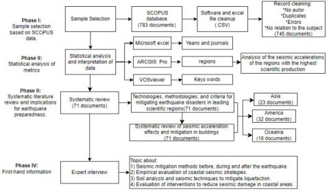
This research has focused on a secondary study using the VOSviewer tool to recognize seismic hazards in the Pacific Ring of Fire and evaluate research possibilities using metrics. The methodology of this study approaches in three phases: I) sample selection from SCOPUS data, II) statistical analysis of metrics about publications using VOSviewer software, and III) systematic literature review and implications for earthquake preparedness [21]. Figure 1 shows the methodological diagram applied in this study.
Figure 1. Outline the methodology for compiling technical criteria in earthquake risk management
2.1 Sample selection based on SCOPUS data
The first step is the selection of the sample with the appropriate data for this research from a reliable source of scientific publications that allow an analysis of seismic hazards, seismic accelerations, and fire belts. There is a debate about the stability and comparability of academic websites such as SCOPUS and Web of Science. For the present study, the data came from the educational information base SCOPUS, which Elsevier owns. SCOPUS is a database with the most significant citations, advanced analytical tools, and peer-reviewed literature contributions for researchers in bibliometric analysis, systematic reviews and v, and various research areas. The SCOPUS database presents multidisciplinary information, storing more than 91 million records.
The second step is the choice of variables or search engines, which consists of a process that avoids obtaining extensive results, focusing the literature in the area of knowledge and limiting too many results. This research considers the documents in which the search was followed in the titles with the following search criteria: seismic acceleration and fire belt, their synonyms, according to the equation: (TITLE-ABS-KEY ("ring of fire*") OR TITLE-ABS-KEY ("circum-pacific belt*") OR TITLE-ABS-KEY ("pacific ring of fire*") OR TITLE-ABS-KEY ("volcanic belt*") OR TITLE-ABS-KEY ("seismic belt*") OR TITLE-ABS-KEY ("fire belt*") OR TITLE-ABS-KEY ("tectonic ring*") OR TITLE-ABS-KEY ("pacific seismic belt*") OR TITLE-ABS-KEY ("volcanic zone*") OR TITLE-ABS-KEY ("seismic ring*") AND TITLE-ABS-KEY ("shak*") OR TITLE-ABS-KEY (motion*) OR TITLE-ABS-KEY (force*) OR TITLE-ABS-KEY (velocity*) OR TITLE-ABS-KEY (upheaval*) OR TITLE-ABS-KEY (intens*) OR TITLE-ABS-KEY (force*) OR TITLE-ABS-KEY (surge*) OR TITLE-ABS-KEY (accelerat*) AND TITLE-ABS-KEY (tremor*) OR TITLE-ABS-KEY (quake*) OR TITLE-ABS-KEY (temblor*) OR TITLE-ABS-KEY (seismic*) OR TITLE-ABS-KEY (earthshock*) OR TITLE-ABS-KEY (groundshaking*) OR TITLE-ABS-KEY (seismicity*) OR TITLE-ABS-KEY ("Richter-scale event*") OR TITLE-ABS-KEY ("Tectonic disturbance*") OR TITLE-ABS-KEY ("Earth motion*") OR TITLE-ABS-KEY ("tectonic event*") OR TITLE-ABS-KEY ("Fault movement*") OR TITLE-ABS-KEY (vibration*) OR TITLE-ABS-KEY ("Shock wave*") OR TITLE-ABS-KEY ("Epicentral disturbance*") OR TITLE-ABS-KEY (earthquake*)).
Researchers searched and downloaded information on March 3, 2024. They downloaded it in CSV (Comma-Separated Values) format from the SCOPUS database and considered several parameters for analysis, such as titles, authors, abstracts, citations, and keywords [22]. As a result, they obtained 783 documents. The team reviewed and cleaned the data and made the following adjustments: removed duplicated information, excluded information without authors, corrected errors, and eliminated information unrelated to the subject matter, leaving 745 of the 783 documents.
2.2 Analysis statistical of publication metrics using Vosviewer software
Microsoft Excel, ArcGIS Pro and Vosviewer used statistical and bibliometric interpretation software.
Microsoft Excel (Office16) was used to clean and debug records without authors, duplicate information, errors, and information not related to the study's subject.
ArcGIS Pro (Version 3.2) was used to represent the scientific contributions of the countries worldwide and the earthquakes by magnitude classified through intervals of magnitudes greater than or equal to 7 that occurred between 1958 and 2023. These seismic magnitude data (with their coordinates) come from the United States Geological Survey (USGS) portal.
And the VOSviewer software (version 1.6.19) to visualize bibliometric keyword co-occurrence networks.
2.3 Review of the literature and implications for earthquake preparedness.
Figure 1 shows the methodology applied for the systematic review and selection of documents for complete analysis. The selection criteria were titles, abstracts, and keywords related to the “mitigation” of earthquake damage; the types of papers analyzed were freely available. Finally, a review of the effects of seismic acceleration showed that the methodology for the systematic review and the selection of documents for the complete analysis is shown in the figure below, using as data the 71 papers used to compile materials and construction techniques used to mitigate the impact of seismic acceleration. This phase provided an understanding of the mitigation plans and methods used before, during and after earthquakes within the fire belt.
2.4 Interviewing experts
Interviews were conducted with experts in different fields of earth sciences, where 4 questions were asked about plans, measures and strategies on mitigation measures for seismic events. This section provides expert criteria for analysing seismic hazard situations in the circumpacific ring, considering the results and contributions of the bibliometric analysis and systematic review.
3.1 Analysis of scientific production and bibliometric review by period
According to the search equation, results were obtained from 1958 to 2023 (See Figure 1), showing significant gaps between these years of study; for example, the scientific production from [1958-1998] was less than [<10 documents] / year, in the period [1998-2015] the scientific production ranges between [10-30] documents/year. And finally, in the period [2015-2023], the scientific contribution oscillates in the following range [31-48] documents/year. 745 publications out of the initial 783 meet the analysis criteria for the subject (See Figure 2). The trend best fits this study is the function (y=0.7227e0.0713x) with exponential growth due to increased scientific production along the graph.
Figure 2. Scientific production of articles on seismic accelerations in the circum-Pacific region (linear and exponential trend fits of the number of publications)
The longitudinal analysis of scientific production and annual seismicity reveals a distinctive correlation between both phenomena. During the periods studied, a sustained increase in the number of scientific publications and citations was observed, peaking in the second (318 papers and 11557 citations) and third periods (320 papers and 3146 citations) (see Table 2), coinciding with a significant increase in the frequency of earthquakes of magnitude greater than 7 on the Richter scale, with the following averages of earthquakes per period: First (12.35); Second (15.54) and third (14.11). This finding suggests a possible interrelation between the advance in seismic acceleration research and recorded seismicity, highlighting the need for a multidisciplinary approach to studying natural phenomena. In the peak years of scientific production, 1981, 1998, 2009, 2019 and 2022 stand out.
In 1981, 9 papers were published and received 420 citations. That year's outstanding events were the World Conferences on Earthquake Engineering and the International Conference on Earthquake Microzonation, held in California, USA. Significant earthquakes in Tangshan, China (1976, magnitude 7.6) and Haicheng, China (1975, magnitude 7.5) influenced these events.
Table 2. Main characteristics of the phases
|
Phase |
Period |
TP |
TP/YEAR |
TC |
TC/TP |
DC |
% DC |
|
I |
[1958-1998] |
107 |
2.6 |
6565 |
61.36 |
4 |
3.74% |
|
II |
[1998-2015] |
318 |
18.71 |
11557 |
36.34 |
32 |
10.06% |
|
III |
[2015-2023] |
320 |
40.00 |
3146 |
9.83 |
72 |
22.50% |
Note-TP: Number of publications; TC: Number of citations; DC: Number of documents without citations.
Papers and conferences 1981 focused on methods for assessing and mapping local seismic hazards, highlighting the importance of seismic microzonation for risk assessment and damage reduction in specific areas [23]. The journal “Tectonophysics” stood out that year, publishing 4 articles on geophysics and plate tectonics. Topics addressed in these articles included seismic refraction, tectonic stresses, seismotectonics, crustal dynamics and interactions between tectonic regions.
In the three years before 1981, 26 earthquakes were more significant than 7 MW, underscoring the relevance of seismic studies during that period. The “Seismicity Pattern in the South Iceland Seismic Zone” study is among the outstanding research, cited 96 times. This research focuses on characterising the South Icelandic seismic zone, highlighting transform motions between the Reykjanes Ridge and the eastern volcanic zone, and identifying earthquake recurrence patterns ranging from 45 to 112 years [24].
In 1998, 18 papers were published and received 972 citations. Among the outstanding events of that year was the 1996 International Conference on Earthquake Engineering, held in Japan (Yokohama), the United States (San Francisco) and Mexico (Mexico City). This event focused on structural engineering and mitigation measures influenced by the 1994 Northridge earthquake in California [25]. Among the 1998 publications, the United Kingdom journal “IOP Conference Series: Earth and Environmental Science” stood out with four articles. The studies focused on seismology, tectonics, geophysics, and geohazard mitigation. Specific topics included crustal structure, volcanism, geohazard monitoring, and earthquake mitigation. In the three years before 1998, 51 earthquakes with a magnitude greater than 7 occurrences occurred, underscoring the importance of the research and conference in seismology and seismic hazard mitigation.
One research highlight was "Focal mechanisms of large earthquakes in the North Island of New Zealand: slip partitioning at an oblique active margin," cited 98 times. This research focuses on identifying fault and stress patterns in the subducted plates of the Taupo volcanic zone [26].
In 2009, 30 papers were registered and received 1219 citations; this was the year with the highest number of citations in the study. Among the outstanding events of that year were the Conference of the Association for Seismology and Physics of the Earth's Interior (2006), the Special Session on Seismic Acceleration in the Ring of Fire (2007) and the International Conference on Seismology and Hazard Mitigation (2008). Organizers held these events in Vienna, Austria, Japan, the United States, Chile, and Indonesia.
The events were related to understanding plate tectonics, risk assessment, seismic accelerations observed in earthquakes and their effects on structures, and seismic mitigation and response strategies. The 2005 Indonesia earthquake, with a magnitude of 9.1 MW, influenced these topics. Among the publications in 2009, the Chinese journal Acta Geophysica Sinica stood out with four articles. The studies explored diverse geophysics, seismology, volcanology, and geodesy areas. Specific focuses included plate tectonics, geothermal energy, natural hazards, and disaster management. One outstanding research study was “Rapid ascent of rhyolitic magma at Chaitén volcano, Chile,” cited 211 times. This research focused on studying the unexpected, explosive eruption of the Chaitén volcano, highlighting the importance of volcanic hazard mitigation for future research [27].
In 2019, 48 papers were published and received 386 citations. Notable journals that year included "Acta Seismologica" (China), "Journal of Asian Earth Sciences" (UK) and "Seismological Research Letters" (USA), each with 3 publications.
The 2019 studies focused on several key areas: seismology, volcanology, geophysics, tectonics, disaster engineering, and monitoring and prediction technologies. One notable research study, "Crustal seismic velocity responds to a magmatic intrusion and seasonal loading in Iceland's Northern Volcanic Zone," has been cited 30 times. This research uses seismic noise interferometry to measure changes in seismic velocity (dv/v) in Iceland's Northern Volcanic Zone [28].
In 2022, the U.S. Journal of Geophysical Research: Solid Earth excelled with 4 publications. Topics investigated included Earth structure, seismic activity, tectonic interaction, predictive technology and infrastructure response. From 2019 to 2022, scientists recorded 36 earthquakes with magnitudes greater than 7. These data show a correlation between scientific output in geosciences and seismic activity, indicating a period of intense research coinciding with significant large-magnitude earthquake events. One research highlight was “New Constraints for the On-Shore Makran Subduction Zone Crustal Structure”, cited 14 times. This research uses simulator models of shear wave velocities in the Makran subduction zone [29].
The year with the highest number of earthquakes greater than 7 during the study periods was 2010, with 24 earthquakes, of which 23 occurred within the fire belt, highlighting the 8.8 Mw earthquake in Chile. In addition, in 2010, there was a devastating earthquake of 7 Mw in Haiti, which caused loss of life, thousands of people injured and billions of dollars in economic losses; Haiti has not yet fully recovered from this seismic event due to the poor preparedness and informality of its constructions [30]. Several congresses and scientific meetings organized by researchers addressed the high seismic activity in 2010. In the following years, they analyzed the causes, consequences, and lessons learned while enhancing mitigation and response strategies for future seismic disasters. [7]. Necessary research included studies on tectonic plate dynamics, soil behaviour during earthquakes, and infrastructure resilience. Relevant conferences included the World Conference on Earthquake Engineering (WCEE) 2012 in Lisbon, Portugal, which brought together engineers to discuss advances in earthquake engineering and lessons learned from the Haiti and Chile earthquakes; the International Conference on Disaster Management (ICDM) 2011 in New York, USA, focused on disaster management and earthquake preparedness as specific sessions on the Haiti earthquake and recovery strategies; the Seismological Society of America (SSA) 2011 Annual Meeting in Memphis, Tennessee, USA, this event presented research on global and regional seismicity, including detailed analyses of the 2010 earthquakes; and the 2011 International Conference on Disaster Management (ICDM) in New York, USA.; The 2013 International Conference on Geotechnical and Earthquake Engineering (ICEGE) in Istanbul, Turkey, highlighted research on soil behaviour during earthquakes and how these investigations can better inform construction practices in seismic zones. The 2012 International Symposium on Earthquakes and Tsunamis (ISET) in Kyoto, Japan, focuses on advances in earthquake and tsunami prediction and mitigation, with case studies on the 2010 seismic events. These meetings, conferences and symposiums enable the development of global best practices and policies on seismic safety.
Period I – Initial Proces [1958-1998]: Period I - Initial Process [1958-1998]: The number of research is 107 published documents, representing 14.38% of the total documents in this bibliometric review and an average of 2.77 documents/year. The number of citations in this period is 6565, representing 30.87% of the total (see Table 2); the publication with the highest number of citations in this period is “The Hellenic Arc and Trench System: A Key to the neotectonic evolution of the eastern Mediterranean area” with 1058 citations published in 1979. The first publication of this period is “Bouguer Anomaly Map of New Zealand”, published in 1958 and cited 17 times, which deals with the anomaly in the tectonic structures and the isostatic equilibrium of the region associated with an active tectonic zone; this contribution provides insight into the geology and tectonics of New Zealand about seismic and volcanic activity. However, there was no scientific production in 1960, 1961, 1962, 1964, 1966, and 1967. The year with the highest number of papers published in this first study period was 1981, with 9 scientific publications. The study on seismic accelerations was focused on the fire region (a region susceptible to earthquakes), as it was in its initial stage. Most of the research dealt with geodynamics discoveries of energy release zones and studies of volcanic activity [31].
Period II: Development process [1998-2015] – This period captures researchers' attention since it leads to the production of 320 publications, which represents 42.95% of the total. The amount of research oscillates increasingly and has a total of 11557 citations, 54.34%. The year with the highest contribution of scientific publications is 2009, with 30 documents. The publication with the highest number of citations was "Kinematics of the Western Africa-Eurasia plate Boundary from Focal Mechanisms and GPS Data ", with 458 citations. At this stage, the following topics stand out: geology and seismology, including studies on the structure and deformation of the lithosphere, volcanic activity, propagation of seismic waves, evolution of geothermal resources and methods of susceptibility to deformations due to elevations and displacements of the earth's surface using the synthetic aperture interferometer radar and the use of horizontal GPS velocities to measure the deformation of the earth's crust [32].
Period III: Maturity [2015-2023] – This period captures researchers' attention since it produces 320 publications, which represents 42.95% of the total, having an average of 45.71 documents/year (See Table 2). In the years 2019 and 2022, the scientific contribution was 48 documents. The number of citations in this period is 3146, representing 14.79% of the total. The publication with the highest citation in this period is "Strike-slip faulting during the 2014 Bároarbunga-Holuhraun dike intrusion, central Iceland", with 116 citations, published in 2016 [33]. Studies conducted in 2019 are focused focus on seismology and seismic behaviour, including volcanic activities, fault structures and the response of the earth's crust to different natural phenomena, the assessment and modelling of natural hazards such as earthquakes and volcanic eruptions, While studies conducted in 2022 focus on the study of volcanic structure and activity (internal structure of volcanoes and their interaction with tectonics), seismic hazard assessment (estimating earthquake hazards and response in different regions), Development of early warning systems and seismic data analysis. This stage stands out from the previous ones since we use technological tools for monitoring tectonic plates using GPS, seismic tomography and geographic information systems, earthquake warning systems with Arduino and a web-based SES60 SLP sensor and the application of equations for prediction, these tools are used to know the behaviour of tectonics and plate dynamics in areas with increased seismic activity.
3.2 Contributions from countries and institutions
Earthquakes greater than 7 Mw (major earthquakes and large earthquakes, according to Andrade and Izquierdo [34] are representative of the serious damage they cause to civil works and the effects or repercussions they leave in their wake. There have been 848 earthquakes of 7-8 Mw, 36 earthquakes of 8-9 Mw, and four earthquakes greater than 9 Mw. Regarding the latter, they occurred in: Chile (Valdivia-1960, 9.5 Mw), United States (Alaska-1964, 9.2 Mw), Indonesia (Sumatra-2004, 9.1 Mw) and Japan (Tohoku-2011, 9.1 Mw) (See Figure 3).
Figure 3. Global contribution on the circumpacific region and earthquakes of magnitude ≥ 7, since 1958
The contribution in research facilitates the related knowledge and skills in search of a shared goal, becoming a progress of scientific study. 27 countries contribute to research on seismic accelerations in the ring of fire, belonging to the continents of Asia, America, Oceania and Europe. Table 3 shows the scientific productivity of the 10 countries with the most contributions. Below, I describe the 5 countries that contribute the most to the research topic. Researchers in China led the group by publishing 204 scientific publications, which have received 3643 citations and contributed to 4 journals with the highest impact in this study, focusing on monitoring and researching fault zones, geophysical technology and early warning systems. Next is the United States, with 149 scientific publications (6134 citations and 5 journals with the highest contribution in this study) focusing its studies on research on tectonic mechanics and monitoring through seismic tomography. New Zealand followed this with 73 scientific publications (3414 citations) focusing its studies on research on tectonic dynamics through geodetic networks, GPS stations, deformation rate and the use of equations for the prediction of seismic movements. Mexico with 71 scientific publications (1896 number of citations) focusing their studies on early warning systems, seismic monitoring and research and understanding of tectonic and volcanic activity; and Japan with 48 papers (1612 citations) focusing their study on Base isolators, tuned mass dampers and research on tectonic dynamics [35]. However, in terms of positions by number of citations, the exact relationship does not hold since the United States is in first place, followed by China, New Zealand, the United Kingdom and France (See Table 3).
Table 3. Scientific productivity of the 10 main research contributing countries
|
Nª |
Country |
TP |
TP% |
TC |
TC/TP |
|
1 |
China |
204 |
23.92% |
3643 |
17.86 |
|
2 |
United States |
149 |
17.47% |
6134 |
41.17 |
|
3 |
New Zealand |
73 |
8.56% |
3414 |
46.77 |
|
4 |
México |
71 |
8.32% |
1896 |
26.70 |
|
5 |
Japan |
48 |
5.63% |
1612 |
33.58 |
|
6 |
Russian |
48 |
5.63% |
605 |
12.60 |
|
7 |
United Kingdom |
43 |
5.04% |
2725 |
63.37 |
|
8 |
France |
41 |
4.81% |
2655 |
64.76 |
|
9 |
Iceland |
32 |
3.75% |
2305 |
72.03 |
|
10 |
Germany |
30 |
3.52% |
1126 |
37.53 |
Note - TP: Number of publications; TC: Number of citations; TC/TP: average citations per publication.
3.3 Analysis of co-occurrence by author keywords
In bibliometric research, Co-occurrence analysis is a technique that allows the understanding of the keywords that are part of the database related to the subject of study. This analysis included i) using the VOSviewer software to represent the network and obtaining 1869 author keywords. ii) The researchers post-processed the keywords to unify similar terms. iii). The study used a threshold of words that appeared at least three times.
In this co-occurrence analysis, there are 65 keywords, the most important being Crust (55 Occurrences), Earthquakes (44 Occurrences), Seismic (32 Occurrences), Volcanic zone (22 Occurrences) and Seismic Belt (21 Occurrences). Figure 4 shows nodes of different sizes (representing the frequency of the term), and the closeness of these nodes indicates their correlation. Additionally, they are differentiated by colour, depending on the central research theme. The minimum cluster word size for this analysis is 6, giving 7 clusters.
Cluster 1: Seismology of the internal structure of the earth (116 occurrences); the term with the highest occurrence is crust (55 times). The studies focus on zones with major tectonic faults, ground dynamics, subduction zones, and seismic response of the ground and volcanic activities. The terms that stand out in this cluster are tectonism and volcanics, which highlight the importance of 3D systems that simulate subduction zones that allow the analysis of the dynamic properties of the soil, study of earthquake migration, studies with interferometry of seismic waves.
El cluster 2: Volcanic monitoring and crustal structure analysis (60 occurrences). The term with the highest occurrence is seismic tomography (14 times). Studies focus on spatial data of tectonic zones, mitigation and technologies to prevent earthquakes in coastal areas. Seismic soundings and gravity models explore internal layers and lithospheric compositions. These methods allow for understanding volcanic activities in the fire region and observing mass redistribution after earthquakes. Broadband seismometers and gravimeters detect elastogravity signals, improving the detection of subduction earthquakes and tsunami warning systems.
Cluster 3: Monitoring of earthquakes and natural hazards (75 occurrences), earthquake is the term with the highest occurrence (40 times). Studies analyze tectonic acceleration hazards and response spectra to measure seismic intensity. Human activities such as mining and oil extraction can induce earthquakes. Predictions use autonomous learning, ionospheric anomalies and seismicity analysis. Arduino-based early warning systems provide real-time detection, although predicting exactly remains difficult.
Figure 4. Keyword network
Cluster 4: Tectonic deformation and volcanic zones (85 occurrences), the term with the highest occurrence is the volcanic zone (22 times). This study focuses on the movement of the Pacific tectonic plates and their interaction with adjacent plates through processes such as subduction, continental drift and lithospheric subduction, leading to volcanic action along its boundaries.
Cluster 5: In regions with high tectonic, seismic and volcanic activity (60 occurrences), the fire belt has the highest occurrence (21 times). This cluster represents the line of study focused on highly seismic zones and the presence of seismic events in this region. Geologic factors contributing to seismic accelerations in the ring of fire are derived from internal geology factors such as mineral composition, structure, pore structure, and saturation, which are geologic factors that affect seismic wave velocities. Deterministic models use seismic sources in the absence of seismicities and unknown recurrence times of event, as well as a predominance in the analysis of shear and surface waves to attenuate seismic events.
Cluster 6: Geodynamic processes in subduction zones (74 occurrences); the term with the highest occurrence is seismic (32 times). This study provides a comprehensive view of the processes occurring in subduction zones, offering valuable information for seismic and volcanic risk mitigation and the exploration and exploitation of geothermal resources. Tectonic processes relate to earthquakes and volcanic activities; earthquakes can trigger volcanic activities, and many researchers attribute these earthquakes to the continuous movement of tectonic plates. When a high energy release occurs in a populated area, it can be destructive. Earthquakes can provoke positive and negative responses to volcanic activity, including increased volcanic activity, decreased gas emissions, and subsidence in volcanic areas.
Cluster 7: Characterization of the Structure and Properties of the Lithosphere by Seismic Tomography of Surface and Shear Waves (68 occurrences), the term with the highest occurrence is tomography (20 times). This study improves our knowledge about the internal structure of the Earth and its processes It addresses the composition and dynamics of the lithospheric layer and the mantle, as well as the seismology, seismic wave propagation, and mountain formation. Low-velocity zones show areas where seismic waves propagate more slowly. There are “P” (primary) waves, which are longitudinal and fast, and “S” (secondary) waves, which are slower and only in solids.
3.4 Synthesis of the literature review
The mitigation of seismic accelerations in the Ring of Fire has generated interest in the scientific literature, creating strategies and methodologies to address the challenges posed by earthquake damage. Several studies highlight the importance of advanced technologies, such as monitoring and early warning, earthquake prevention and resistant construction, geotectonic research and tectonic dynamics, active control systems and materials technology. These tools allow for a more agile and effective response to disasters, ensuring that communities are prepared [36].
The evolution of building codes in the fire belt regions has been essential to strengthening the earthquake resistance of infrastructure. The literature indicates that these regulations integrate advances in engineering and lessons learned from previous events, reflecting a global development towards seismic risk mitigation. Furthermore, the tectonic complexity of the Ring of Fire highlights the importance of considering geological variables in the design and planning of infrastructure, ensuring that constructions are adequate for the specific seismic conditions of each region [37].
Figure 5. Earthquake mitigation solutions in ring of fire regions and average seismic accelerations
Table 4. Mitigation methods in the fire belt regions
|
Regions |
Mitigation Countries and Methods |
Regulations, Years, Observations and Organizations |
|
North America |
United States: early warning systems such as ShakeAlert (Kohler et al. 2020), probabilistic seismic risk analysis, base isolation and energy dissipater designs, building material quality regulation, use of seismographs and fibre optic sensing [9]. |
Uniform Building Code (UBC) since 1927, and the International Building Code (IBC) in 2000. United States Geological Survey (USGS), Network for Earthquake Engineering Research (NEES) since 2004. Implement innovative materials such as high-strength steel and ductile concrete [32]. |
|
North America |
Canada: advanced numerical modelling of structures [9, 10], use of viscous and metallic dampers, continuous monitoring by borehole seismographs and fibre-optic detection systems. |
National Building Code of Canada (NBCC) since 1941, with updates every five years. National Building Code of Canada (NBCC), universities, Canadian Seismographic Network (CSN) [10]. |
|
North America |
Mexico: Mexican Seismic Alert System (SASMEX), evaluation and reinforcement of existing buildings, use of reinforced masonry shear walls and prestressed concrete, monitoring using borehole seismographs and fibre optic detection systems [12]. |
Building Regulations for the Federal District (RCDF) since 1976, 1988 (CENAPRED), 1991 (SASMEX). National Center for Disaster Prevention (CENAPRED), Mexican Seismic Alert System (SASMEX). Implementation of innovative technologies and materials to build resilient structures [9]. |
|
South America |
Ecuador: Risk assessment through geological and seismic studies (NEC-15) [2], implementation of sensor networks and advanced technologies such as GPS to monitor tectonic movements, regular drills and training, National Plan for Seismic Risk Reduction. |
Specific regulations. Geophysical Institute of the National Polytechnic School (IG-EPN) [3]. |
|
South America |
Peru: Early warning systems (SASPe), dynamic analysis and simulations to evaluate structural behaviour, seismic vulnerability assessment programs, reinforcement and rehabilitation of buildings, and use of advanced technologies such as GPS to monitor tectonic movements. |
Technical Building Standard E.030. Geophysical Institute of Peru (IGP). |
|
South America |
Chile: early warning systems, assessment and reinforcement programs for old buildings, real-time monitoring technologies, use of improved building materials, earthquake drills, training and continuing education programs (SAE) [11]. |
Chilean Standard NCh433. National Seismological Network (RSN), National Emergency Alarm System (SAE) [11]. |
|
Asia |
China: advanced earthquake engineering, urban planning, use of innovative synthetic materials in concrete, continuous monitoring of seismic and volcanic activity, simulation of seismic events, post-earthquake monitoring with aerial and satellite imagery [36]. |
Specific earthquake engineering regulations. Since the 1960s and 1970s, reinforced after the 2008 Sichuan earthquake. Evaluation and repair of damaged structures using new materials such as concrete and advanced polymers. |
|
Asia |
Japan: real-time early warning and monitoring systems, updated building codes, simulation of future seismic events, use of aerial imagery and satellite data for post-earthquake monitoring, rapid damage assessment with drones [36]. |
Building codes have been continuously updated since the 1960s, especially after the Kobe earthquake in 1995 and the Tohoku earthquake in 2011 [13]. |
|
Asia |
Philippines: public awareness, use of innovative synthetic materials in concrete, continuous monitoring of seismic and volcanic activity, simulation of seismic events, post-earthquake monitoring with aerial and satellite imagery, use of drones [36]. |
It was strengthening of infrastructures. Since the 1970s, it intensified after the 1990 Luzon earthquake. |
|
Asia |
Indonesia: public awareness, use of innovative synthetic materials in concrete, continuous monitoring of seismic and volcanic activity, simulation of seismic events, post-earthquake monitoring with aerial and satellite imagery, use of drones [36]. |
It was strengthening of infrastructures. Since the 1980s, it has intensified after the 2004 Indian Ocean earthquake. |
|
Oceanía |
Australia: Early detection systems (EDS), educational programs and emergency drills, disaster response plans, geotechnical studies and mapping of risk areas, improvement of construction materials, buffer technologies and international cooperation. |
Building codes with seismic requirements. Geoscience Australia, seismic monitoring network [16]. |
|
Oceanía |
New Zealand: Use of seismic dampers, base isolation systems, geotechnical surveys, mapping of risk zones, use of advanced numerical models, real-time monitoring techniques. |
New Zealand: Use of seismic dampers, base isolation systems, geotechnical surveys, mapping of risk zones, use of advanced numerical models, real-time monitoring techniques [17, 18]. |
In the literature review, the contribution of the 3 regions with the highest scientific contribution within this study were considered, among these countries are: China (204 publications), United States (149 publications), New Zealand (73 publications), Mexico (71 publications) and Japan (48 publications), giving a total of 545 scientific papers, however subsequently a search was performed by keywords, abstract and title, from the Excel clean database, with the search words (mitigation), where 71 scientific papers were obtained, where 23, 20, 12 and 16 belong to the regions of Asia, North America, South America and Oceania respectively (See Figure 5). The contribution of these regions in terms of mitigation measures, technical and engineering criteria, methodologies, software and use of technologies used before, during and after a seismic event will be detailed below.Before a seismic event, advanced monitoring technologies, such as GPS networks and digital seismographs, must be implemented. During a seismic event, early warning systems and structural resilience play important roles in damage mitigation. Subsequently, rapid damage assessment using drones and satellite imaging technologies facilitates recovery planning [38].
3.5 Analysis of seismic acceleration mitigation plans
The 3 most influential continents were analyzed in this study of seismic accelerations within the fire belt: Asia, America and Oceania. The average seismic response values were calculated using the SAP 2000 software (see Table 4), with seismic acceleration for soils type “D or 4” in this case, this type of soil has been considered due to its denomination of soft soils and due to its characteristics, such as low load capacity, high compressibility. It has significant settlement potential with its low load; the building codes of each region govern these calculations. It has high seismic accelerations, which can cause intense vibrations during earthquakes. It risks infrastructure (hospitals, schools, or other vulnerable structures), especially structures with high vibration periods built with low-quality materials and high seismic risks. These houses are vulnerable due to their height and the potential for greater oscillation during an earthquake. Inferior building materials may not withstand these forces, which can lead to structural collapse and endanger the lives and safety of the inhabitants [36].
Comparative analysis of seismic responses and building codes in coastal regions of the Ring of Fire, focusing on the countries with the most significant scientific contribution (China, United States, New Zealand, Mexico and Japan), reveals substantial differences. In Asia, the high average seismic acceleration of 0.985 g indicates a high vulnerability to infrastructure damage and economic impacts The average seismic acceleration in North America is 0.580 g, while in South America, it is 0.531 g, reflecting the specific regulations developed for each region. Oceania has an average seismic acceleration of 0.393 g, reflecting its regulations focused on geotechnical ground variability.
Japan and the United States, located in areas of high seismic activity, have high acceleration levels in their regulations. In Japan and the USA, high seismic accelerations (1.52 g and 1.00 g) indicate a high vulnerability to infrastructure damage and economic impacts. New Zealand, also in the Ring of Fire, focuses its regulations on geotechnical soil variability [39]. China shows a more moderate acceleration due to the stringency of its building codes, and Mexico, with low seismic acceleration, considers geological factors and specific regulations for urban areas [40].
Differences in seismic regulations reflect geological, historical and technical factors. Japan and the United States incorporate advanced technologies such as seismic isolators, while China adopts new technologies gradually. Mexico has improved its constructions after significant earthquakes, although there may be variability in applying advanced technologies. Strict regulations in Japan and post-disaster revisions in Mexico reflect adaptation to the specific characteristics of each region, considering its geology, history of seismic activity, and technological capabilities [40].
Geotechnical approaches and construction technologies vary. New Zealand specifies soil types in its regulations, allowing a design more adapted to local conditions [18]. Regulations in North America (ASCE7-10) and South America (NEC-15, E030; NCH 433-2009) reflect tailored approaches. In Oceania, the standards focus on geotechnical soil variability.
Although these countries experience high seismic accelerations (see Table 5), it is essential always to consider these acceleration spectra when adapting and configuring construction manuals that complement the local building codes in each region. In addition to the direct relationship between acceleration spectra and the design of structures, it is crucial to consider other factors such as soil type, building characteristics, nonlinear behaviours and elastic analysis during evaluation [37].
In the Ring of Fire regions, such as Asia, America and Oceania, employ advanced strategies to mitigate the effects of seismic accelerations through stringent regulations and specific technologies. In Asia, countries such as Japan and China use seismic isolators, tuned mass dampers, viscous dampers, friction dampers, reinforced steel, high ductility concrete, and site evaluation reflecting these data in their building regulations [14]. In North and South America, standards such as ASCE 7-10, Mexico NTC-2004, and NEC-15, E030, NCH 433-2009 [11] incorporate geotechnical studies and detailed structural analyses to ensure seismic-resistant buildings employing advanced technologies and resistant materials. With regulations such as NZS 4203 and AS11704-2007, Oceania specifies soil types and adopts flexible design techniques and seismic isolation systems [41]. Other measures to mitigate the effects of seismic accelerations include seismic hazard mapping, safety of nonstructural components and seismic hazard mitigation programs.
Table 5. Soil seismic accelerations. Type (D) and applied standards of the three continents with the highest scientific productivity and subduction depth data extracted from the USGS database
|
Regions |
Normative |
Average Seismic Accelerations (g) |
Subduction Depths (Km) |
|
ASIA |
Chínese 2010; IBC |
0.985 |
Low: 30.0 Average: 67.5 High: 135.0 |
|
NORTH AMERICA |
ASCE 7-10; México NTC-2004 |
0.580 |
Low: 25.0 Average: 62.5 High: 85.0 |
|
SOUTH AMERICA |
NEC-15; E030; NCH 433-2009 |
0.531 |
Low: 36.67 Average: 70.00 High: 106.7 |
|
OCEANIA |
NZS 4203; AS11704-2007 |
0.393 |
Low: 20.0 Average: 45.0 High: 60.0 |
In all these regions, seismic acceleration data is integrated into building design through specific regulations, detailed analysis of local conditions, and the implementation of appropriate technologies and materials to ensure structural resilience to seismic events.
3.6 Expert interview
Information obtained through interviews with geological specialists was as in Table 6.
Table 6. Expert interviews
|
Question |
Response (Mitigation Measures) |
|
1) What are the most commonly used mitigation methods (before, during and after) of a seismic event? |
- Seismic warning systems: Such as those implemented in Mexico, which issue early warnings between 12 and 65 seconds before the earthquake. - Mobile applications: “Sismo Detector” warns of the estimated time of arrival of the seismic wave. - Earthquake-resistant construction: Regulations that promote the use of technologies such as seismic dissipators. |
|
2) What empirical methods have been used most successfully to evaluate the effectiveness of anti-seismic strategies? |
- Empirical and construction methods: Use of beams and braces, cube-shaped design to improve seismic performance. |
|
3) How to combine soil analysis methods with seismic engineering techniques for liquefaction zones? |
- Soil analysis and Ecuadorian standard: Soil classification according to seismic velocity (profiles A-F). It is proposed to combine direct methods (drilling) with indirect methods (measurement of fundamental periods of the soil). |
|
4) What methodologies are used to measure the effectiveness of government and community interventions? |
- Land studies and territorial planning: Adjustment of planning in areas such as Salinas to avoid resonance and structural collapse, using seismic dissipaters. - Pilot projects and monitoring of seismic swarms in vulnerable regions. |
The research reveals a remarkable increase in scientific production on seismic accelerations in the Pacific belt over 65 years, highlighting crucial technological advances for risk mitigation in a highly vulnerable region. Since 2015, an exponential growth in scientific publications stands out, as evidenced by the analysis of 745 publications, where 86.50% are scientific articles, 9.00% are conference papers, 1.93% are book chapters, 0.13% are conference reviews, 0.13% are letters, 2.19% are reviews, and 0.13% are short surveys. This increase in scientific literature underscores the recognition of the hazards and damages caused by these natural phenomena, providing a solid basis for future research and mitigation strategies.
The study focused on five countries highlighted in the fire belt for their influence on the analysis of seismic accelerations in type D or 4 soils, known for their low bearing capacity and high compressibility [42]. Using SAP 2000 software, seismic responses were determined, revealing that Japan and California presented the highest accelerations (1.52 g and 1.00 g, respectively), indicating significant vulnerability for infrastructure. In contrast, Mexico registers accelerations (0.16 g) (in regions of Mexico such as North-East Region (Baja California and Baja California Sur), Center-North (San Luis Potosi and Zacatecas), Altiplano (State of Mexico, Aguascalientes and northern parts of Jalisco) in the latter its seismic accelerations oscillate in a range of [0.10 - 0.15] g, attributable to its seismic regulations adapted to high seismic activity. This analysis highlights the need to adjust construction manuals according to local acceleration spectra, considering soil type and structural behaviour, strengthen resilience to seismic events [43].
Sixty-five significant keywords were identified, with “Crust”, “Earthquakes”, “Seismic”, “Volcanic zone”, and “Seismic Belt” as the most frequent. The keyword network reflects thematic correlations, defining seven main groups: internal seismology, volcanic monitoring, tectonic deformation, natural hazards, tectonic activity, geodynamic processes and lithospheric characterization by seismic tomography.
The methodologies and technologies used in earthquake damage mitigation have three phases: before, during, and after the seismic event. Before, urban planning and the construction of resilient structures are critical, supported by the identification of seismic amplification zones. and the use of advanced technologies such as seismographic networks and Early Detection System (EDS) [44]. The incorporation of new synthetic materials in concrete and continuous monitoring using GPS and fibre optics contribute to earthquake preparedness and resilience. These preventive measures ensure constant vigilance and a rapid response capability to changing geological conditions.
During and after an earthquake, measures focus on minimizing damage and facilitating recovery. During the event, the resilience of structures and base isolation play a crucial role, along with rigorous building codes and real-time monitoring. Identifying risk areas and using numerical models allow an immediate and effective response. After the earthquake, structures' evaluation and repair, control isolators' implementation, and waste management are essential for recovery. The seismic data analysis and using technologies such as drones and satellite imagery and recovery planning [45]. Continuous improvement of the warning system and protection of water resources ensure a comprehensive and effective response to seismic disasters.
Since 1958, Pacific Ring of Fire countries have made significant progress in earthquake damage mitigation through key evolutionary steps. Japan led the way in developing anti-seismic codes, revising them after the 1995 Kobe earthquake. Chile implemented similar improvements after the Valdivia earthquake 1960 and revised its standards after the Maule earthquake 2010. The United States, especially California, strengthened its codes and monitoring systems after earthquakes such as the 1994 Northridge [42]. New Zealand revised its regulations after the 1968 Inangahua and 2011 Christchurch earthquakes. Indonesia and the Philippines, following devastating disasters such as the 2004 Indian Ocean tsunami and the 1990 Luzon earthquake, respectively, also strengthened their monitoring codes and networks [46]. These countries have generally adopted building codes and early warning systems to increase earthquake resilience.
Seismic building regulations in Japan, Chile, the United States, New Zealand [18], and the Philippines present critical similarities in their seismic building codes, reflecting a common approach to seismic risk mitigation. These regulations reflect a shared focus on seismic risk mitigation, prioritizing structural strength, material ductility and building integrity. The codes and standards of these countries focus on reducing seismic vulnerability through advanced engineering practices and structural protection techniques, evidencing a global commitment to the resilience of infrastructure to seismic events. All of these countries have implemented stringent and regularly updated building codes, such as the Japanese Building Code, Chilean Standard NCh433, the U.S. International Building Code (IBC), New Zealand's CCH and PCO codes, and the Philippines' DPWH regulations, which incorporate the latest advances in earthquake engineering and lessons learned from recent events. These codes specify strict seismic design criteria, including dynamic analysis, resistance to seismic loads, and the use of appropriate materials, requiring simulations and computational modelling to evaluate structural behaviour under different seismic scenarios.
Differences in seismic regulations reflect geological, historical and technical factors. Japan and the United States incorporate advanced technologies such as seismic isolators. At the same time, China is adopting new technologies gradually, including neoprene elastomer seismic isolators (ELR), tuned mass dampers (TMD), metal-based energy dissipation systems, advanced seismic simulation models, real-time monitoring technologies, and innovative building materials. Mexico has improved its constructions after significant earthquakes, although there may be variability in applying advanced technologies. Strict regulations in Japan and post-disaster revisions in Mexico reflect adaptation to specific characteristics of each region, considering its geology, history of seismic activity, and technological capabilities [47].
Although countries located in the Asian and North American regions experience high seismic accelerations, it is essential always to consider these acceleration spectra when adapting and configuring construction manuals to complement local building codes in each area. In addition to the direct relationship between acceleration spectra and the design of structures, it is crucial to consider other factors such as soil type, building characteristics, nonlinear behaviours and elastic analysis during evaluation [48].
Evaluation of depths in subduction zones reveals variations in minimum and maximum mean depths. In Asia, a mean depth of 67.5 km is observed, varying from 30 km to 135 km. This variability is attributed to the tectonic complexity of the region, where multiple tectonic plates interact. In North America, the mean depth is 62.5 km, with minimum and maximum depths of 25 km and 85 km [49]. This lower variability is due to differences in convergence rates and plate geometry. In South America, with Ecuador, Chile and Peru, an average depth of 70 km is recorded, ranging from 36.67 km to 106.67 km [50]. This region presents an active and dynamic subduction, especially along the Andes Mountains, where the Nazca and South American plates interact.
The results obtained from the interview highlight the effectiveness of early warning systems and mobile applications, although the proximity of the epicentres could limit their implementation in worldwide. Empirical construction methods, such as using beams, regular infrastructure design, and soil classification according to international regulations, improve structural strength, especially in vulnerable coastal areas. Including seismic dissipaters and measuring fundamental soil periods reinforce mitigation strategies in areas at risk of liquefaction.
This paper focuses on analyzing 745 documents through a bibliometric review and 71 documents through systematic literature reviews on seismic accelerations in the regions that are part of the Pacific Ring of Fire due to the high frequency of earthquakes, which present an average seismic acceleration value of 0.62 g and average range [0.393-0.985]. Based on a bibliometric study and comparison of seismic accelerations in different countries, several methodologies for seismic risk mitigation use advanced monitoring methodologies, such as GPS networks and digital seismographs, for early detection and analysis of tectonic movements. In addition, with seismic engineering data, they have developed more resilient structures using innovative materials, such as high ductility concrete, advanced polymers and technological building materials, which combine polymers with concrete and ecological alternative materials, complying with international regulations and aligning with SDG 9 and 11.
The systematic literature review on seismic risk mitigation has identified methodologies used depending on the geographic regions. In Asia (Japan and China), they have implemented advanced early warning systems, seismic isolators, tuned mass dampers, viscous and frictional dampers, and continuous assessment of vulnerable zones. Significant events such as the Kobe (Japan) and Sichuan (China) earthquakes have strengthened these methods, which have led to updates in their building codes. In North America, regulations such as the Uniform Building Code (UBC) and the International Building Code (IBC) complemented by U.S. Geological Survey (USGS) research and early warning systems such as ShakeAlert, have been adopted, complemented by research by the United States Geological Survey (USGS) and early warning systems such as ShakeAlert. In South America, countries such as Chile and Peru have developed building codes, seismic monitoring networks and early warning systems to improve the resilience of their infrastructure; in Oceania, technologies such as seismic isolators and energy dissipation systems have been implemented, as well as seismic microzonation techniques to design structures adapted to local conditions. Also, techniques such as differential interferometry have included monitoring ground subsidence, using three-dimensional tire-derived geosynthetics to maintain high permeability under compressive loads, and using carbon fibre and nano-silica to improve shear strength and soil cohesion. Other methods include the injection of air bubbles into sandy soil to reduce saturation, the simplified Seed-Idriss method to assess liquefaction, and using energy dissipaters to mitigate seismic effects.
Building codes and seismic-resistant regulations vary significantly among the regions of the Ring of Fire, reflecting their different geological and historical contexts. Due to high seismic accelerations in Japan and the United States, they have implemented specific requirements in areas of high seismicity. Given China's moderate average seismic acceleration, engineers have adopted building codes. Mexico has improved its regulations after significant earthquakes, with variability in applying advanced technologies. In Oceania, applying specific standards such as NZS 4203 and AS11704-2007 focuses on the geotechnical variability of the soil, allowing a design more adapted to local conditions. These approaches reflect the adaptation to specific characteristics of each region, considering geology, history of seismic activity, and technological capabilities. However, they emphasize the importance of incorporating data on seismic accelerations in the design of structures to ensure their resilience to seismic events.
Seismic mitigation measures combine advanced technology, seismic-resistant regulations and soil studies to reduce damage in vulnerable areas. Integrating direct and indirect methods in soil evaluation and adapted land planning is crucial. Pilot projects and seismic dissipaters highlight the importance of government interventions to improve resilience to future earthquakes.
This study could serve as a basis for future regional and global research, as it explains how seismic movements impact structures. This would allow decision makers to propose mitigation plans based on technical criteria, building codes and applicable manuals, along with the use of technological tools validated by the scientific community, such as seismic sensors, seismic remote sensing, magnetic sensors, energy dissipaters, and passive, active and semi-passive seismic isolation systems. In addition, implementing technological building materials could be considered, such as combining polymers with concrete and ecological alternative materials with similar or higher efficiency than traditional ones, complying with national and international regulations and aligning with Sustainable Development Goals 9 and 11.
Limitations of this article include: i) details of the processing and instrumentation used in this methodology, ii) limited information on countries with fewer studies involving seismic attenuation factors in some areas of the Pacific Ring of Fire (Papua New Guinea, Vanuatu and Timor-Leste), being a young country. iii) use of a single database, SCOPUS.
We are grateful to the ESPOL research project “Management and Evaluation of Scientific Research in Earth Sciences, Economics, Management and their links with Society.” with Code CIPAT-7-2022. We also thank Engineer Fernando Morante, Engineer Paul Carrión, Engineer Maria Fernanda Quiñonez of the secretary of Risk Management (SGR acronym in spanish) and Engineer Kervin Chunga Morán Ph.D. (researcher of Manabi Technical University), for their valuable contribution in the interview and for collecting the information first hand.
[1] Kumar, S., Singh, A.K. (2021). Earthquake hazards and monitoring of seismo-ionospheric precursor. In Recent Technologies for Disaster Management and Risk Reduction: Sustainable Community Resilience & Responses, Cham: Springer International Publishing, pp. 27-40. https://doi.org/10.1007/978-3-030-76116-5_2
[2] Morante-Carballo, F., Santos-Baquerizo, E., Pinto-Ponce, B., Chacón-Montero, E., Briones-Bitar, J., Carrión-Mero, P. (2024). Proposal for the rehabilitation of houseshold in seismic vulnerability zones. International Journal of Safety and Security Engineering, 14(3): 701-716. https://doi.org/10.18280/ijsse.140304
[3] IGEPN. (2011). En Chile Promulgan Normas de Construcción Más Estrictas. https://www.igepn.edu.ec/servicios/noticias/360-en-chile-promulgan-normas-de-construcción-más-estrictas.
[4] Tomoya, E., Ioan, Takagi, H., Nguyen, T., Matsumaru, R., Mikami, T., Ohira, K., Ohtani, A. (2012). Implicaciones del tsunami de Tohoku del año 2011 para la gestión de desastres naturales en Japón. Obras y Proyectos, 11: 4-17. https://doi.org/10.4067/S0718-28132012000100001
[5] Young, A., Flament, N., Maloney, K., Williams, S., Matthews, K., Zahirovic, S., Müller, R.D. (2019). Global kinematics of tectonic plates and subduction zones since the late Paleozoic Era. Geoscience Frontiers, 10(3): 989-1013. https://doi.org/10.1016/j.gsf.2018.05.011
[6] Abdillah, F.A., Juhadi, J., Darmawanti, I. (2023). EMITVEL (Earthquake Mitigation Visual Novel): Media for learning earthquake mitigation in elementary schools. International Journal of Social Learning (IJSL), 3(2): 202-221. https://doi.org/10.47134/ijsl.v3i2.175
[7] Tiansong, Z., Shujun, L., Shihai, Z. (2010). Design and application of a digital classification instrument for engineering site seism-resistant design. 2010 Chinese Control and Decision Conference, 252-256. https://doi.org/10.1109/CCDC.2010.5499078
[8] Abdulqader, D.N., Atrushi, D.S. (2022). Evaluation and assessment of existing design codes and standards for building construction. Aro-The Scientific Journal of Koya University, 10(2): 106-123. https://doi.org/10.14500/aro.10983
[9] IBC. (2018). International Code Council. (2018). International Building Code 2018. International Code Council, Incorporated. https://codes.iccsafe.org/content/IBC2018P6.
[10] NBCC. (2015). National Building Code of Canada 2015 (Vols. 1-2).
[11] NCh433. (2019). NCH 433 Diseño Sismoresistente. https://www.preventionweb.net/files/28726_normachilenadisenosismico.pdf.
[12] Normas Mexicanas NMX. (2014). http://www.nyce.org.mx/formatos/normalizacion/CatalogoNormasNYCE2014.pdf.
[13] Tomohiro, H. (2013). Building Regulation in Japan. In Building Center of Japan (Issue July).
[14] GB 50010-2010. (2010). National Standard of the people`s Republic of China. https://es.scribd.com/document/438014378/GB-50010-2010.
[15] DPWH. (1977). The National Building Code (P.D. 1096) (Issue 6541).
[16] BCA. (1996). Building Code of Australia.
[17] PCO. (2017). Building Act 2004. In Mbie (Issue January). http://legislation.govt.nz/act/public/2004/0072/latest/DLM306036.html.
[18] CCH. (2011). Code de la construction et de l’ habitation (Issue C). https://www.legifrance.gouv.fr/codes/texte_lc/LEGITEXT000006074096/.
[19] Masum, M., Ali Akbar, Md. (2019). The pacific ring of fire is working as a home country of geothermal resources in the world. IOP Conference Series: Earth and Environmental Science, 249: 012020. https://doi.org/10.1088/1755-1315/249/1/012020
[20] Barrientos, S. (2018). The seismic network of Chile. Seismological Research Letters, 89(2A): 467-474. https://doi.org/10.1785/0220160195
[21] Solórzano, J., Morante-Carballo, F., Montalván-Burbano, N., Briones-Bitar, J., Carrión-Mero, P. (2022). A systematic review of the relationship between geotechnics and disasters. Sustainability, 14(19): 12835. https://doi.org/10.3390/su141912835
[22] Morante-Carballo, F., Montalván-Burbano, N., Aguilar-Aguilar, M., Carrión-Mero, P. (2022). A bibliometric analysis of the scientific research on artisanal and small-scale mining. International Journal of Environmental Research and Public Health, 19(13): 8156. https://doi.org/10.3390/ijerph19138156
[23] Dolce, M., Bramerini, F., Castenetto, S., Naso, G. (2019). The Italian policy for Seismic Microzonation. In Earthquake Geotechnical Engineering for Protection and Development of Environment and Constructions, CRC Press, pp. 925-937. eBook ISBN: 9780429031274.
[24] Einarsson, P., Björnsson, S., Foulger, G., Stefánsson, R., Skaftadóttir, T. (1981). Seismicity pattern in the South Iceland seismic zone. Earthquake Prediction: An International Review, 4: 141-151. https://doi.org/10.1029/ME004p0141
[25] Dahlman, O., Ringdal, F., Mackby, J., Mykkeltveit, S. (2020). The inside story of the Group of Scientific Experts and its key role in developing the CTBT verification regime. The Nonproliferation Review, 27(1-3): 181-200. https://doi.org/10.1080/10736700.2020.1764717
[26] Webb, T.H., Anderson, H. (1998). Focal mechanisms of large earthquakes in the North Island of New Zealand: Slip partitioning at an oblique active margin. Geophysical Journal International, 134(1): 40-86. https://doi.org/10.1046/j.1365-246x.1998.00531.x
[27] Castro, J.M., Dingwell, D.B. (2009). Rapid ascent of rhyolitic magma at Chaitén volcano, Chile. Nature, 461(7265): 780-783. https://doi.org/10.1038/nature08458
[28] Yadav, D.N., Kumar, N., Babu, V.G., Kumari, R., Pal, S.K. (2022). Crustal velocity structure and seismotectonics of the Kinnaur region of northwest Himalaya: New constraints based on recent micro-earthquake data. Journal of Asian Earth Sciences, 224: 105005. https://doi.org/10.1016/j.jseaes.2021.105005
[29] Priestley, K., Sobouti, F., Mokhtarzadeh, R., A Irandoust, M., Ghods, R., Motaghi, K., Ho, T. (2022). New constraints for the on-shore Makran subduction zone crustal structure. Journal of Geophysical Research: Solid Earth, 127(1): e2021JB022942. https://doi.org/10.1029/2021JB022942
[30] Alteus, P. (2017). Earthquake risks in Haiti: An analysis of response and preparedness strategies for the design of a new mitigation approach. Louisiana State University and Agricultural and Mechanical College. https://doi.org/10.31390/gradschool_theses.4306
[31] Suter, M., Quintero, O., Johnson, C.A. (1992). Active faults and state of stress in the central part of the Trans‐Mexican Volcanic Belt, Mexico 1. The Venta de Bravo Fault. Journal of Geophysical Research: Solid Earth, 97(B8): 11983-11993. https://doi.org/10.1029/91JB00428
[32] Hammond, W.C., Kreemer, C., Blewitt, G. (2009). Geodetic constraints on contemporary deformation in the northern Walker Lane: 3. Central Nevada seismic belt postseismic relaxation. Late Cenozoic Structure and Evolution of the Great Basin–Sierra Nevada Transition, 447: 33-54. https://doi.org/10.1130/2009.2447(03)
[33] Ágústsdóttir, T., Woods, J., Greenfield, T., Green, R.G., White, R.S., Winder, T., Brandsdóttir, B., Steinthórsson, S., Soosalu, H. (2016). Strike-slip faulting during the 2014 Bárðarbunga‐Holuhraun dike intrusion, central Iceland. Geophysical Research Letters, 43(4): 1495-1503. https://doi.org/10.1002/2015GL067423
[34] Andrade, C., Izquierdo, D. (2023). Durability and cover depth provisions in next Eurocode 2. Background modelling and calculations. Hormigón y Acero, 74(299-300): 19-40. https://doi.org/10.33586/hya.2023.3102
[35] Ramírez-Herrera, M.T. (1998). Geomorphic assessment of active tectonics in the Acambay graben, Mexican Volcanic Belt. Earth Surface Processes and Landforms, 23(4): 317-332. https://doi.org/10.1029/2021JB022942
[36] Wang, C., Lü, D. (2023). Response prediction and its determination of design value for RC frame structures under uniform risk spectra. Jianzhu Jiegou Xuebao/Journal of Building Structures. https://doi.org/10.14006/j.jzjgxb.2022.C034
[37] Worku, A. (2014). Soil-structureinteraction provisions: A potential tool to consider for economical seismic design of buildings? Journal of the South African Institution of Civil Engineering, 56(1): 54-62.
[38] Magill, C., Blong, R. (2005). Volcanic risk ranking for Auckland, New Zealand. I: Methodology and hazard investigation. Bulletin of Volcanology, 67(4): 331-339. https://doi.org/10.1007/s00445-004-0374-6
[39] Dovzhenko, O., Pohribnyi, V., Klymenko, Y., Fenko, O. (2023). Accident prevention of buildings and structures based on two-level assessment of bearing capacity of structures. In AIP Conference Proceedings, 2684: 030009. https://doi.org/10.1063/5.0120474
[40] Yabe, S., Ide, S., Yoshioka, S. (2014). Along-strike variations in temperature and tectonic tremor activity along the Hikurangi subduction zone, New Zealand. Earth, Planets and Space, 66(1): 142. https://doi.org/10.1186/s40623-014-0142-6
[41] ASCE 7-10. (2010). ASCE Standard Loads for Buildings. In Minimum Design Loads for Buildings and Other Structures.
[42] Nolasco, M., Bocco, M., Scavuzzo, C.M. (2018). Agricultural surfaces mapping based on spectral data and non-contemporary field reference. In 2018 IEEE Biennial Congress of Argentina (ARGENCON), San Miguel de Tucuman, Argentina pp. 1-7. https://doi.org/10.1109/ARGENCON.2018.8646305
[43] Lo, R.C. (2022). Lessons learned from two earthquakes that afflicted Mexico city—after a pause of 32 years. In Lifelines 2022, 310-321. https://doi.org/10.1061/9780784484449.028
[44] Gomberg, J.S., Masters, T.G. (1988). Waveform modelling using locked-mode synthetic and differential seismograms: Application to determination of the structure of Mexico. Geophysical Journal International, 94(2): 193-218. https://doi.org/10.1111/j.1365-246X.1988.tb05896.x
[45] Oviedo, J.A., Duque, M.D.P. (2006). Sistemas de control de respuesta sísmica en edificaciones. Revista EIA, (6): 105-120.
[46] Boroschek, R., Bonelli, P., Restrepo, J. I., Retamales, R., Contreras, V. (2014). Lessons from the 2010 Chile earthquake for performance based design and code development. Performance-based seismic engineering: Vision for an earthquake resilient society, 32: 143-157. https://doi.org/10.1007/978-94-017-8875-5_11
[47] Mayoral, J.M., Asimaki, D., Tepalcapa, S., Wood, C., Roman-de la Sancha, A., Hutchinson, T., Franke, K., Montalva, G. (2019). Site effects in Mexico City basin: Past and present. Soil Dynamics and Earthquake Engineering, 121: 369-382. https://doi.org/10.1016/j.soildyn.2019.02.028
[48] Hashiguchi, K. (2014). Elastic Constitutive Equations, Elastoplasticity Theory, 69: 123-129. https://doi.org/10.1007/978-3-642-35849-4_5
[49] Gong, C., Blum, M.D., Wang, Y., Lin, C., Xu, Q. (2018). Can climatic signals be discerned in a deep-water sink? An answer from the Pearl River source-to-sink sediment-routing system. Bulletin, 130(3-4): 661-677. https://doi.org/10.1130/B31578.1
[50] USGS. (2024). Earthquake USGS. https://earthquake.usgs.gov/earthquakes/map/?extent=-9.44906,-126.5625&extent=67.60922,-63.28125.