Maha A.S. Alsorori* | Mohamed A.S. Almadhagi | Amal M. Alghashm
© 2026 The authors. This article is published by IIETA and is licensed under the CC BY 4.0 license (http://creativecommons.org/licenses/by/4.0/).
OPEN ACCESS
Cities are undergoing rapid urban transformation driven by the challenges of globalization, digital and technological developments, and environmental and social changes, which require a radical review of traditional patterns in urban design. These patterns show a clear deficiency in responding to structural, visual, aesthetic, and functional variables, as they are no longer able to respond to modern variables. The study begins with an essential problem: the continued adoption of rigid, limited traditional patterns in urban landscape design, which lack flexibility and adaptability. The study raises a central question regarding the possibility of adopting an interactive urban landscape as an alternative epistemic model to the traditional one. This study aims to analyze the philosophical structure of the interactive urban landscape as an advanced design framework. It further seeks to critique the conceptual and functional shortcomings of the traditional landscape. The study adopts a qualitative, interpretive, and critical analytical approach. It utilizes a conceptual framework derived from philosophical literature. It concludes that interactive urban design can overcome the structural and functional failures of traditional landscapes and enhance systemic urban performance, especially in developing environments.
digitalization, interactive, interactive urban landscape, technological developments, urban landscape
Modern urban thought is experiencing a structural evolution in its view of the city and its functional, visual, and aesthetic landscape. Consequently, the rapid changes imposed by technological and digital transformations have led cities to be reshaped through smart systems that rely on integrating technologies, such as artificial intelligence and the Internet of Things [1, 2], evolving into a dynamic environment that responds to human behavior and surrounding conditions [3]. Despite this, many developing cities are still subject to the dominance of traditional design, which is characterized by inertia, formal rigidity, and conceptual closedness. In traditional design, interactive and technological design is excluded from the urban design process, which reflects a limited capacity to respond to the requirements of modern cities [4]. This contributes to widening the gap between the technological and typical traditional urban reality in developing cities. From this standpoint, the need has emerged to formulate alternative urban models based on an interactive philosophy capable of transcending design inertia, working to provide an interactive urban landscape that integrates humans, technology, and knowledge within a dynamic, flexible urban environment. Herein emerges the main research problem: the conflict between the continuity of traditional patterns in designing the urban landscape and the necessity of shifting towards a flexible, interactive urban system capable of accommodating the changes of the accelerating world. Cities are no longer static physical entities, but rather have turned into dynamic, spatial interactive systems that engage their users in real-time [5]. This transformation requires a rethinking of their urban design according to modern, interactive principles. Thus, a set of basic questions emerged: What are the philosophical dimensions of the interactive urban landscape? What are the tools that distinguish it from the traditional landscape? What are the differences between them? And what are the most prominent obstacles that may prevent the activation of this concept in developing countries in particular? The main objectives were determined by analyzing the integrated philosophical structure of the idea of applying the interactive urban landscape, identifying the structural and functional differences between the traditional and interactive urban landscapes, and outlining its future vision. Despite the abundance of studies that have addressed smart cities from a technical perspective, the literature lacks explanatory models that integrate the philosophical dimension of the interactive urban landscape in the context of developing cities. Hence, the importance of this research lies in its direct relevance to fundamental issues in modern urban design, as it seeks to enhance cities’ capacity to respond effectively to contemporary urban needs. The investigation is guided by the following hypothesis: the interactive urban landscape constitutes an alternative epistemic framework capable of transcending the limitations of traditional design patterns by reshaping the urban space based on the pillars of community participation, design flexibility, and technological integration. This approach aims to enhance the city’s capacity to adapt to the modern urban context, achieve the highest degree of functional and visual adaptation, and meet users’ needs according to their changing behaviors.
This study adopts an interpretive qualitative research approach grounded in philosophical and conceptual analysis. Consistent with the interpretivist tradition articulated by Creswell and Creswell [6] and Lincoln and Guba [7], the research seeks to explore the underlying philosophical and theoretical foundations of the interactive urban landscape and its departure from the static characteristics of the traditional urban landscape. The analysis is based on a purposive review of philosophical, critical, and urban studies literature, with particular attention to scholarly works addressing the conceptual dimensions of smart and interactive cities. Through this process, a set of analytical concepts and interpretive dimensions was derived to examine the transformation of urban landscapes from static physical settings into dynamic, responsive, and interactive environments. Rather than aiming to generate empirical findings, the study develops a conceptual framework that enables a critical interpretation of contemporary urban transformations. To support this framework, a series of original conceptual figures was produced by the researchers. These figures function as analytical visualizations that synthesize the theoretical relationships identified in the literature and illustrate the conceptual transition from urban stasis to urban interaction, which constitutes the central analytical theme of the study.
2.1 Literature identification and selection strategy
The literature underpinning the conceptual analysis was identified through a purposive, criterion-based search of Scopus, Web of Science, and Google Scholar, selected for their disciplinary coverage of urban design, architecture, and philosophy of technology. The search combined the keywords interactive urban landscape, digitalization, technological developments, responsive urban design, interactivity, static versus dynamic urban space, and philosophy of technology and the city, used individually and in Boolean combination (e.g., interactive landscape and urban design). Contemporary literature on smart and interactive urbanism (2002–2026) was combined with seminal theoretical works on urban form and townscape predating this period [8-11], included for their foundational status in the theoretical genealogy of urban design critique. Sources were included if they addressed at least one of three thematic domains central to the study: (1) the conceptual or philosophical critique of static/traditional urban design, (2) the theorization of interactivity, responsiveness, or adaptability in urban environments, or (3) documented case studies of digitally integrated urban projects. Sources were excluded if they were purely technical or engineering-focused without conceptual or design-oriented discussion, if they constituted non-peer-reviewed grey literature, or if they were non-English publications without accessible translation. This process resulted in a final corpus of 52 sources informing the conceptual framework and case analysis.
2.2 Derivation of analytical dimensions
The analytical dimensions presented in the interaction framework were derived through systematic thematic synthesis of the literature corpus, where recurring conceptual categories were iteratively coded, grouped, and validated against the study's foundational distinction between static and dynamic urban space. Each dimension was subsequently cross-verified against the empirical characteristics of the case studies to ensure the framework was grounded in both theoretical literature and documented practice. The resulting six-factor model was then operationalized through conceptual relations that synthesize the theoretical relationships identified in the literature and map the transition from urban rigidity to interactive urbanism, thereby establishing an auditable and replicable analytical foundation for the study’s central argument.
The theoretical and philosophical conceptual framework is an essential input for understanding the profound transformations that have occurred in the thought of the urban landscape in recent decades. Considering the challenges of globalization and the widening of the efficiency gap between the traditional design and the dynamic requirements of the contemporary city, it has become necessary to dismantle and expand the concepts associated with the urban landscape, to understand the nature of the ongoing transition from the fixed, closed formal models to the interactive, dynamic epistemic ones. This means the positioning of concepts within their transforming philosophical context, shifting from a rigid entity based on strict physical organization to an interactive, dynamic system.
3.1 The urban landscape
It is defined as the spatial and visual composition resulting from the interaction of natural, structural, and cultural elements within the urban environment. This formation reflects the city’s level of development and sophistication, and its expression of its history, identity, and social structure. This is achieved through spatial relationships, urban formation, and finally the user's sensory experience [12]. Allain [13] defined it as thought and vision through which facts can be seen and visualized. It requires being seen and studied through a medium-scale analysis that falls between detailed plans and comprehensive master plans. The urban landscape is also understood as a social space full of meaning, formed through the interaction of physical, social, and communal dimensions of the city [14]. Young [15] defined it as the three-dimensional phenomenon through which humans move among buildings, floors, roads, and trees. It is also known as the final visual landscape that collects architectural components such as masses, urban elevations, and green spaces [16]. It can further be understood as the art of the landscape and everything that appears to the observing human that can be perceived by the senses and seen by the eye, integrating with the urban environment through a sense of place and human experience [17].
3.1.1 Urban landscape theories
The theory emerged to understand the nature of urban form, and can be divided into two basic theories: the theory of the place, and the theory of spatial space. The first one means the integrative relationship between a person and the place in which he lives, which helps to form the personal and psychological aspects of the human being, while the theory of spatial space conceptualizes the urban landscape as a space for human needs through the study of people's characteristics and needs [18]. There are many urban landscape theories, the most important of which are three theories. The first is Gordon Cullen’s theory [11], which organized the urban landscape by studying the relationship that links the components of the landscape with each other. The second is Spreiregen's theory [19], which explains that the urban landscape consists of a group of material elements, such as building materials, texture, etc., and other immaterial elements represented by movement, sounds, and activities that work to formulate and create the urban landscape. The third theory is Broadbent's theory [20], which explains that the organization of the urban landscape is done through the formation of the structures surrounding the landscape and the organization of their relationship with the surrounding spaces, utilizing a group of geometric shapes, such as a circle, a rectangle, and others.
3.1.2 Philosophy of the traditional urban landscape
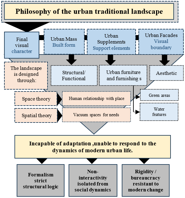
The philosophy reflects design patterns that prevailed in the pre-technological and pre-knowledge transformation. This philosophy is based on a closed and fixed conception of the urban domain, in which the landscape is understood as a set of formal elements arranged according to a strict structural and functional logic, isolated from the dynamics of human use and social interaction. In addition, it is incapable of adapting to the changes of the modern era. The following is an analysis of the most prominent features of this traditional approach:
-Focus on form and general appearance over meaning: The landscape is viewed as a formal structure subject to the rules of visual consistency, geometric gradation, and architectural harmony. This approach reflects formal aesthetics, whereby the aesthetic appearance becomes the goal of the city, without any consideration for the social interactive experience [21].
-Absence of dynamic interaction: The traditional landscape produces a static space, incapable of interacting with modern requirements. Design is made according to strict rules, the designer is separated from the user, and functions are restricted to closed domains, all without considering daily social and cultural transformations [10].
-Dominance of the bureaucratic style: The bureaucratic pattern in the production of the urban landscape is one of the most prominent features of traditional thought, where the urban landscape is organized through highly central institutions that depend on rigid design standards, while marginalizing popular practices and the actual needs of users. In short, this pattern leads to the production of a city as a commodity away from the actual needs of the population [22].
It is clear from the previous analysis that the philosophy of the traditional urban landscape, despite its formal consistency and the rational organization it carries, lacks the spirit of interactivity and human meaning. It is based on a unilateral vision, in which the user is neglected, as shown in Figure 1. This compelled the contemporary urban landscape to re-frame the relationship between people and the urban environment by creating an interactive urban landscape.
Figure 1. Philosophy of the traditional urban landscape
3.2 The concept of interactivity
Interactivity refers to the dynamic and reciprocal exchange of actions, responses, and meanings among individuals within a social context, through which participants mutually influence one another via communication and shared experiences. As synthesized in secondary literature [23, 24], the conceptualization of "Symbolic Interactionism"—initially coined by Herbert Blumer in 1937—builds upon George Herbert Mead’s foundational premise that human interaction is mediated through socially constructed symbols and meanings. Scholars reviewing this framework also emphasize the influence of Charles Horton Cooley’s looking-glass self, which illustrates how self-identity is formulated through social exchange. Based on these secondary accounts, interactivity is interpreted as an iterative process wherein meaning is continuously generated, negotiated, and transformed through social engagement.
3.2.1 Philosophy of interaction theory
The dimensions of interaction philosophy are represented by the capacity of the urban landscape to respond to the actions of individual users, and to enhance interaction among them to create an integrated dynamic experience through the integration of three main dimensions: The interaction between humans and the urban place; the interaction of people within that environment; and the digital interactions through the use of digital technologies to provide the necessary information to users of the urban landscape [25].
3.3 Interactive urban landscape
The interactive urban landscape is a dynamic, interconnected composition that responds in real-time. It merges digital techniques in the urban components of the landscape to create a more adaptive and responsive environment, characterized by its capacity to sensitize human behavior and environmental changes, and adapt to these changes to enhance the spatial performance of the urban landscape. This stands in direct contrast to that static traditional urban landscape [26]. It is also defined as a spatial and visual composition that is formed through dynamic reactions between physical elements and cultural, social, and economic interactions that occur within it [27].
3.3.1 Objectives of the interactive urban landscape
The most prominent objectives of a successful urban landscape can be summarized in the following four points: function, aesthetics, identity, and interaction as follows [9, 12]:
-Function: This means the optimal allocation and designation of land use, including zones (commercial, residential, administrative, etc.) and urban spaces. Functional activities in urban spaces can be divided into three types: the necessary activities, such as shopping, going to work, and school; optional activities, like going to the park or cinema; and finally, social activities that occur through communication with others.
-Aesthetics: Aesthetics was first introduced as a distinct philosophical concept by the German philosopher Baumgarten [28], who defined it as a form of perceptual, sensory-based cognition, an understanding that has since become widely accepted within the philosophical tradition. Aesthetic perception is generally characterized by a set of visual qualities—form, unity, diversity, proportion, texture, color, and harmony—as noted by Sitte [29] and Gibberd [30]. This visual understanding was later extended to include a subjective dimension, reflecting the view that beauty is perceived through the viewer's personal emotions and mental disposition, as emphasized by Kaplan and Kaplan in 1989 [31].
-Identity: Here, identity means the physical and spiritual associations that humans make with history over time. The concept of identity in the urban landscape, according to Lynch [9], lies in the extent to which a person can identify some place through its various features and characteristics that distinguish it from other places.
-Interaction: It is an important element that redefines the relationship between people and the urban domain through enabling the landscape to give an instant response to the user's behavior and changing needs. This interaction works by integrating smart technologies with the infrastructure to produce an adaptable urban environment.
3.3.2 Interactive urban landscape tools
The interactive landscape is built on an integrated system of digital tools and smart technologies that reshape the relationship between humans and the urban sphere, enabling them to respond in real time and continuously adapt to changing uses and behaviors [32]. Among its most prominent tools are:
-Augmented reality technologies (AR): AR is one of the most important tools used for creating a multi-dimensional urban experience, as it allows the projection of digital information onto physical spaces, which contributes to enhancing the sensory, functional, and cultural perception of the urban place. This technology allows the user to interact with urban elements in an interactive and visual manner [33].
-Internet of Things (IoT): IoT constitutes the smart infrastructure that connects buildings, urban spaces, and users in real time using smart sensors and tracking systems to measure urban performance indicators such as air quality, movement, and to reset the landscape according to spatial and temporal variables [34].
-Geographic information systems (GIS): A central analytical tool for managing and analyzing spatial data in the interactive landscape, enabling urban pattern tracking and land use analysis through temporal and interactive mapping, which contributes to making design decisions based on accurate evidence, and integrates environmental and social data [35].
-Smart applications: They form the interactive interface between the user and the urban landscape, allowing access to services, mobility, energy management, real-time information, and submitting civil reports.
-Open urban data: It is used to analyze urban performance, monitor public behavior, and direct policies and planning decisions in real life. This data contributes to enhancing transparency and stimulating innovation [36].
3.3.3 The characteristics of the interactive landscape
The characteristics of the interactive landscape stem from the triad of real-time response, community participation, and digital integration, which makes it an effective tool for reshaping the relationship between humans and the urban landscape. The most prominent characteristics of the interactive urban landscape can be listed as follows [37, 38]:
-Real-time response (instantaneous response): The ability to respond immediately to environmental and behavioral inputs through smart sensor technologies.
-Effective community participation: It is based on a participatory design with users to enhance the sense of urban belonging.
-Flexibility: The urban landscape is not fixed, but is adjustable according to event, time, user behavior, and changing environmental conditions.
-Digital integration: Integrating smart interactive technologies such as sensors, the IoT, and GIS.
-AI urban performance management: This means analyzing behavioral patterns and predicting future uses.
-Enhance the spatial experience and urban functions through users’ perception of the urban environment, such as sound, movement, and interactive media, which turns it into a multi-sensory experience.
3.3.4 The philosophy of the interactive urban landscape
This concept represents a qualitative shift in contemporary urban thought, in which the city is transformed from being a constant static structure to a dynamic, moving system that interacts in real-time with its users and the surrounding environment. This transformation is not merely a technical development but reflects a profound epistemological shift in understanding the relationship between humans and the field. It is based on integrating the techniques of urban intelligence, social participation, and data flow.
In this context, the urban landscape is no longer a design or formal output, but has become a vital medium for communication between man and the city, which is formed by responding to behavioral and environmental changes in real time. This philosophy is based on the concept that the city is not produced by designers, but through mutual relationships between users, technology, and the environment, which makes it more open, flexible, and adaptable [5, 39]. Tarek et al. [26] explained in their study that the interactive urban landscape must answer several questions, namely, who is the user? What is the quality and function of the content? And how is interaction generated [22, 40]? Ultimately, the philosophy of interactive urban landscape redefines the city as a living, responsive entity rather than a fixed product of design, reflecting a deeper epistemological shift in how relationship between humans and the urban field is understood. This calls for rethinking urban design practices to prioritize adaptability, participation, and real-time responsiveness as core values shaping future cityscapes, while grounding this rethinking in fundamental questions of who the user is, what the content offers, and how interaction is generated.
3.3.5 Stages of the development of the urban landscape concept from static to interactive
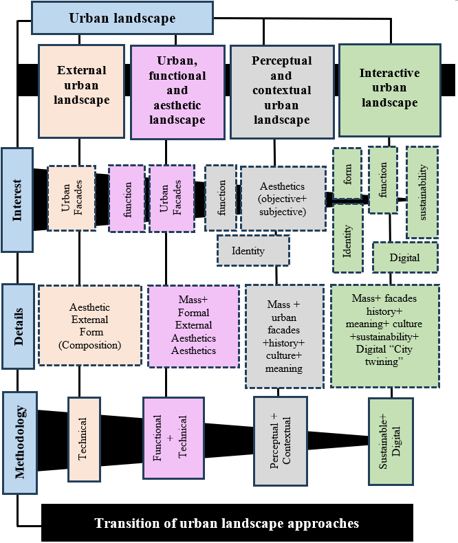
The urban landscape has gone through developmental stages, starting with the traditional urban landscape and ending with the interactive one (see Figure 2). At each stage, a specific approach is used. Each of these approaches follows a set of design standards, and the majority of them share a common focus on the study of massing and facades (aesthetics). These approaches are the technical approach, the functional approach, the contextual-perceptual approach, and finally the digital, sustainable approach [41].
Figure 2. The stages of urban landscape development
3.3.6 A comparison between the traditional urban landscape and the interactive landscape
Contemporary urban changes, with their digital, environmental, and sociological transformations, have shown a need to reconsider the formation of the urban landscape. In this context, there is a philosophical and analytical comparison between the traditional urban landscape, which represents the classical formal vision, and the interactive landscape that represents a digital-technological cognitive vision based on the principles of adaptation, interaction, and community participation. The comparison aims to highlight the shift from the logic of closed, rigid design centered on form, to an open interactive logic based on human and technical communication and interaction across three basic levels: concept, function, and formation mechanisms, as detailed in Table 1.
Table 1. A comparison between traditional and interactive urban landscapes
|
No. |
Aspects |
Traditional Urban Landscape |
Interactive Urban Landscape |
|
1 |
Conceptual difference/from static form to dynamism |
A group of blocks organized geometrically according to formal and aesthetic standards, designed by a higher authority through the urban planner and designer. |
A dynamic, changing field, grounded in sensory and functional experience and urban intelligence through interaction with the user and the surrounding environment. |
|
2 |
Functional/from-fixed and strict organization to adaptive performance |
Urban spaces are divided according to function: residential, commercial, leisure, and mixed-use spaces are prohibited. The urban space is separate from social behavior. |
Allows for multifunctionality and overlapping of activities according to changing needs. Urban space emerges from, and is supported by, social interaction. |
|
3 |
Formation mechanisms/from bureaucracy to effective participatory modeling |
It is based on planning and design standards pre-determined by governmental and central institutions. It does not respond to any variables. |
Relies on data analysis tools, environmental sensing, and real-time community participation. Responds quickly to any variables via smart systems. |
3.4 Analysis of the evolution of new urban design theories
All new urban design theories depend on studying the relationship between the urban environment and human behavior, and directing various design processes to achieve sustainable and effective urban environments. They are known as life theories and are concerned with designing buildings, squares, and public spaces to enhance human interaction and improve social relationships. The most prominent modern theories that have emerged can be explained as follows [42, 43]:
-Architecture and urban theory: It appeared in the sixties and seventies (1960s-1970s) of the last century as a movement counter to the concept of complete elimination and includes a group of principles such as urban dedication, adaptive reuse, and urban preservation. Its idea is based on preserving the valuable components and integrating them with the modern context by studying the relationship between mass and urban space. The theory follows the principle “function follows form”.
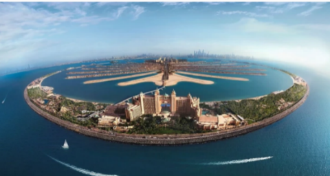
-Theory of partial similarity: A means of partially expressing things that derive their value from nature, cosmic phenomena, and living organisms. It is an effective modern toolkit for the urban designer that allows him to use sinuous lines to reflect a strong sense of movement and harmony. It helps in developing modern urban designs that reflect real life and human interactions with the surrounding nature. It requires knowledge, culture, and imagination to weave metaphorical ideas. This theory can be detailed into four types: the first is symbolic, which is a symbolic theory of myths, history, and ancient ideas of societies, the second is hybrid, which is a simulation of shapes derived from the universe and nature, the third is psychophysical, which is a metaphysical metaphor based on moral aspects, and the last is fractal, which relies on flexible surfaces with the utilization of digital systems. An example of the application of the theory of partial similarity on the ground is the maritime urban landscape of the Sydney Opera House, which derived its ideas from sails and was also said to be inspired by shells [44]. The second is the giant Palm Jumeirah mega-development in Dubai, which consists of three artificial islands known as the Palm Islands, as shown in Figures 3 and 4.
-Sustainable development theory: This theory focuses on producing sustainable urban environments that meet the needs of the present while guaranteeing the rights of future generations, based on the use of renewable materials, reducing carbon emissions, and using solar and wind energy.
-Garden City theory: According to Howard [8], the Garden City Theory promotes a balanced relationship between urban development and the natural environment through the integration of green belts, public open spaces, and residential neighborhoods. The concept emphasizes sustainable urban growth and the provision of healthy living environments by ensuring continuous access to nature within the urban fabric.
-Environmental design theory: It depends on the complementary relationship between the environment and humans, and assumes that urban design is in line with picturesque nature to enhance biodiversity in the urban environment.
-Technological/modernist city theory: This theory focuses on the use of technology and modern data to improve the quality of life in cities, especially in developing countries, and is based on energy management and the use of intelligent transportation systems.
-The theory of humanizing cities: This theory is a turning point in urban design theories. Urban engineer Jacobs [10] is considered the primary founder. In her work, she criticized plans to develop ancient cities, replaced them with diversity of uses, and placed humans at the forefront to enhance social interaction and improve the quality of life.
3.5 Manifestations and constraints: A reading of success and obstacles in the transition toward interactive urban landscape
This section explores the dual nature of the nature of the transition toward interactive urban landscape, presenting concrete manifestations of successful implementation drawn from global case studies, alongside the persistent constraints that continue to hinder broader adoption.
3.5.1 Justification for case selection
The three cases were purposively selected because each captures a different register of interactivity, mapping onto the study’s core distinction between static and dynamic urban space: Virtual Singapore represents interactivity through digital representation, informing planning before physical change occurs; Haeundae Park represents it through embodied experience, where design reshapes visitors' direct engagement with place; and Masdar City represents it through systemic transformation, integrating mobility, energy, and infrastructure into a single adaptive whole. Overall, the cases trace a continuum from simulation to lived experience to full urban integration, offering triangulated evidence for the study’s argument that traditional urban rigidity is giving way not to one technological model, but to several coexisting forms of interactivity.
3.5.2 Case studies of successful implementation of the interactive urban landscape
The applied models were selected based on purposeful sampling (Purposive Sampling), as these cases represent a clear embodiment of interactive and digital transformation in the urban landscape and provide rich material for the philosophical and critical analysis adopted by the study, including the following:
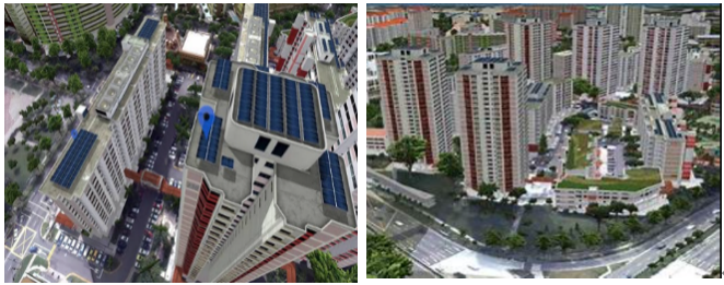
(1) Case 1: Virtual Singapore Project: A national digital project launched by the Singaporean government in 2014 to create a 3D digital twin for the entire city (see Figure 5). The project is managed through collaboration between the National Research Foundation (NRF), the Singapore Land Authority (SLA) and the Government Technology Agency (GovTech), allowing planners and designers to test multiple urban scenarios using digital data, by providing an interactive platform that helps in making decisions related to infrastructure and sustainable development [46]. The most prominent technical and functional components of the project are:
-3D Digital Twin: A high-resolution 3D model, created using Light Detection and Ranging (LiDAR) and aerial photography techniques. It includes precise details of infrastructure, buildings, public spaces, and even the smallest details, such as seats and lampposts.
-Digital data integration: The digital model is integrated with live data from sensors distributed throughout the city, which dynamically analyzes all the necessary information from traffic, air quality, energy consumption, and more.
-A multipurpose interactive platform: The platform provides tools for urban planners and designers, researchers, companies, and even citizens to analyze different scenarios, such as risk assessment and the impact of new construction on traffic, among many others.
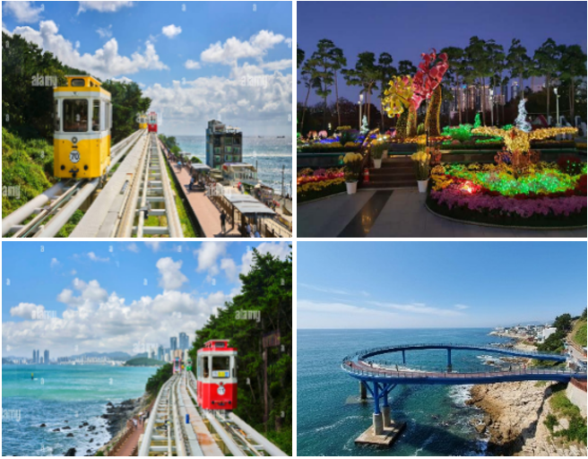
(2) Case 2: Haeundae Park – South Korea: It is one of the successful projects that represents the transformation from the traditional infrastructure environment to an urban interactive environment. The park was developed by integrating interactive technology with environmental design, where digital technologies were employed and integrated to enhance interaction between visitors and the surrounding environment. The design shows interest in achieving environmental and social sustainability by providing interactive entertainment spaces that enhance the quality of urban life [47]. Its most notable features include (see Figure 6):
-Integrating technology with urban spaces: Employing advanced technologies, such as GIS, environmental sensors to monitor air quality, manage lighting, and provide real-time information to visitors.
-Interactive pathways and public facilities: The park features interactive pathways equipped with smart lighting that changes according to the movement of visitors, in addition to rest areas equipped with digital information about the surrounding environment to enhance user experience and encourage interaction with the urban space.
-Smart transportation: The project includes the Haeundae Beach Train and the Sky Capsule, which are eco-friendly electric-powered vehicles providing a unique experience in which people move along the coast, which enhances the attractiveness of the park and reduces carbon emissions.
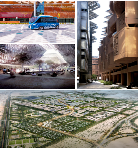
(3) Case 3: Masdar City Project: One of the sustainable interactive projects in Abu Dhabi. It was launched in 2006 by Masdar Company. It relies on renewable energy and advanced environmental design [48]. Its most prominent features are:
-Sustainable architectural design: The project was designed in a style that combines traditional architecture and modern technologies, where narrow and elevated streets were designed to direct the wind and provide natural ventilation.
-Renewable energy: The city relies on renewable energy sources (solar, wind) to meet its electricity needs and reduce carbon emissions.
-Smart mobility: The city provides a smart transportation system that includes self-driving electric vehicles and a personal rapid transit (PRT) system that reduces dependence on traditional vehicles, enhancing air quality [49].
-The use of multiple types of interactive furniture, such as interactive lampposts equipped with sensors, the use of mobile interactive shades that open and close when needed, and colorful interactive floors (see Figure 7).
3.5.3 Comparative analytical framework
To ground the study’s conceptual argument in verifiable analysis rather than description alone, the three cases are systematically compared across six indicators central to interactive urbanism: digital infrastructure, real-time responsiveness, user participation, adaptability, sustainability, and scalability, as detailed in Table 2.
The comparative framework shows that interactivity is not a uniform condition but a differentiated spectrum: Virtual Singapore leads in digital infrastructure and adaptability as an anticipatory model preceding physical space; Haeundae Park leads in user participation, embedding interactivity in everyday sensory experience; and Masdar City, strongest in sustainability, shows that systemic interactivity works best when integrated into environmental design rather than added onto it. This supports the study’s central argument: the shift from a static to an interactive urban landscape follows not one technological trajectory, but several distinct strategies: simulation, experience, and systemic integration.
Table 2. A comparative analysis of the three case studies
|
No. |
Indicator |
Virtual Singapore |
Haeundae Park |
Masdar City |
|
1 |
Digital infrastructure |
Very high-LiDAR-based 3D digital twin, city-wide sensor network |
Moderate-localized smart lighting and information systems |
High-integrated smart grid, PRT, sensor-equipped furniture |
|
2 |
Real- time responsiveness |
High-live data integration for scenario testing |
Moderate-dynamic lighting responsive to visitor movement |
High-autonomous mobility and adaptive shading systems |
|
3 |
User participation |
Moderate-mainly planners, researchers, institutional actors |
High-direct visitor interaction with pathways and transport |
Moderate-residents interact with smart infrastructure |
|
4 |
Adaptability |
Very high-designed explicitly for scenario simulation |
Moderate-fixed infrastructure with responsive elements |
High-systemic flexibility across mobility and energy |
|
5 |
Sustainability |
Indirect-supports sustainable planning decisions |
Moderate-environmental design integration |
Very high-core design objective (renewable energy, passive cooling) |
|
6 |
Scalability |
High-national/city-wide model, transferable to other-twin projects |
Low-moderate-site specific, limited transferability |
Moderate-holistic model, context-dependent replicability |
3.5.4 Structural, organizational, and legislative obstacles in activating interactive urban transformation
During the time when global cities are witnessing an increasing trend towards interactive and smart urban transformations, many cities, especially in developing and urbanely deteriorating contexts, still face major obstacles that limit the activation of this transformation. These obstacles do not lie in the weakness of the digital infrastructure or the lack and limitations of resources, but rather expand to include structural and legislative obstacles that affect the institutional framework, organizational structures, and legal systems that govern the urban design process [51, 52].
Structural obstacles:
-Lack of integrated digital infrastructure: Many cities, especially deteriorating and developing ones, lack the smart infrastructure capable of accommodating the IoT, GIS, and environmental sensors, which is the basis for shaping and essence of the interactive urban landscape.
-Institutional separation between the concerned authorities: Due to the lack of coordination between planning institutions, technological authorities, municipalities, and local actors, it becomes impossible to establish a system capable of embracing the concept of the interactive landscape.
-Weak human resources and technical expertise: There is a clear lack of competencies capable of managing urban data, analyzing it, and translating it into interactive design decisions.
Legislative obstacles:
-The rigidity of legal and regulatory frameworks and their lack of development: Many urban design laws rely on traditional organizational models, based on fixed, inflexible classifications, and do not allow adaptation to the nature of interactive and renewable uses of the smart landscape. (This is what the United Nations referred to in 2020, under the title “Urban Law is a Key Tool for the Transformation of Cities” [51].)
-Lack of legal recognition of smart technologies as design and planning tools: Many building and design legislations, especially in developing countries, still do not legally recognize smart tools such as open data systems, as approved references in making design and planning decisions, which weakens the possibility of their use and effectiveness in these countries.
-Insufficient mechanisms for community participation and participatory governance: The absence of formal, clear, and binding mechanisms to involve the local community in developing urban policies hinders the activation of participatory design despite its importance in building an interactive landscape.
4.1 Results
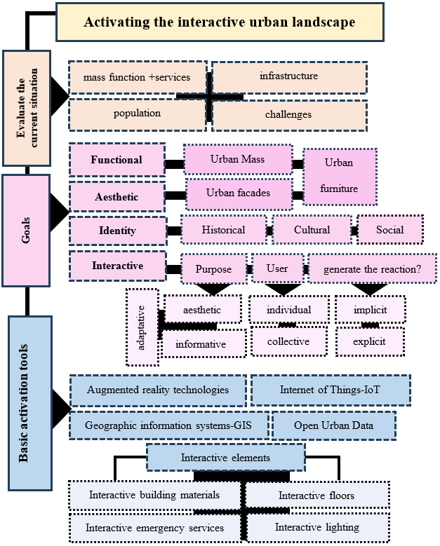
The analysis yields three principal results. First, the comparative assessment of the three case studies (Table 2) shows that interactivity does not manifest uniformly but is distributed unevenly across the six comparative indicators, with each case embodying a distinct operational strategy- representational, experiential, and systemic- rather than a single technological model. Second, synthesis of the literature produces a six-factor interaction framework (Table 3): consolidating role of interaction, type of user, mode of response, scope of interaction, perception scale, spatial experience into a unified analytical matrix. Third, application of this matrix generates an activation model (Figure 8) that structures the practical transition from static to interactive urban design around four sequential goals- functional organization, aesthetic quality, identity, and interactive purpose- supported by defined technological tool. These three results form the conceptual and analytical basis for the interpretation developed below.
Figure 8. Activating the interactive urban landscape
Table 3. Interaction framework: Factors, characteristics, and analytical indicators
|
No. |
Factor |
Characteristics |
Indicators |
Explanation |
|
1 |
Role of Interaction |
Aesthetic Informative Adaptive |
Physical vs. Digital interaction Functional vs cultural meaning |
Aesthetic: Feeling the beauty and satisfaction of the urban space. Informative: Providing systematic and useful information to users of the urban landscape. Adaptive: Adapting to environmental and climatic conditions including weather, movement, and noise. |
|
2 |
Type of User |
Individual Collective Mass Users |
User as observer vs. user as Digital participant |
Users interact with the components of the urban landscape either individually, collectively, or as part or large crowds, shaping the scale and nature of engagement. |
|
3 |
Mode of Response |
Explicit implicit |
Real time interaction vs. mediated (digital) interaction |
Explicit: Interacts directly with the behavior of users in real time. Implicit: interacts indirectly through affiliated digital media and mediated technologies. |
|
4 |
Scope of Interaction |
Local /Near Remote |
On site experience vs. remote (screen- based) perception |
Local / Near: The user interacts directly through on site sensation devices. Remote: The user experiences interactive behavior through digital media that enable participation from a distance. |
|
5 |
Perception Scale |
Holistic Selective Sequential |
Whole scene vs. detail-based perception |
Holistic: Perceiving the urban scene as a unified visual and spatial composition. Selective: Focusing attention on specific elements, details, focal points within the scene. Sequential: Perceiving the landscape progressively through movement, framing, and successive viewpoints. |
|
6 |
Spatial Experience |
Embodied Mediated Hybrid |
3D physical experience vs. 2D visual/ digital experience |
Embodied: Direct, three-dimensional bodily experience of physical urban space. Mediated: Two dimensional visual or digital representation |
4.2 The conceptual framework of interaction in the urban landscape
To transition from abstract critique to a structured analytical tool, this study synthesizes the extensive literature review into evidentiary framework, crystallized in Table 3. This table does not merely summarize existing theories; it establishes the formal result of qualitative synthesis by mapping the operational dynamics of interactive landscape across six interdependent factors: functional roles, user typologies, reaction mechanisms, spatial relationships, perception scale, and spatial experience. The matrix serves as a generative taxonomy that decodes how static urban design mutates into responsive environments, which works as the empirical backbone of theoretical analysis, providing a rigorous, multidimensional benchmark necessary for evaluating contemporary interactive installations and guiding future urban designs.
4.3 Activating the interactive urban landscape
The findings indicate that activating the interactive landscape is not achieved through technological imposition alone, but through a structured convergence of situational awareness, goal clarity, and tool appropriateness. The framework developed in this study, as rendered in Figure 8, establishes that meaningful activation must begin with a rigorous reading of the existing urban condition, its functional capacities, infrastructural realities, population dynamics, and inherent challenges before any design intention is pursued. From this diagnostic foundation, four goal dimensions emerge as inseparable: functional organization, aesthetic quality, place identity, and interactive purpose, each informing the other rather than competing for priority. Technological tools augmented reality, GIS, IoT, and open data platforms—are then positioned not as ends in themselves, but as instruments whose value is contingent on the precision of the goals they are enlisted to serve, working alongside material interactive elements to ensure that engagement remains as embodied as it is digital. What the framework ultimately argues is that the interactive urban landscape is not a product to be delivered, but a condition to be cultivated, one that evolves continuously through the relationship between the environment's designed affordances and the lived responses of those who inhabit it.
4.4 Discussion: From stasis to interaction
These results indicate that the shift from the traditional to the interactive landscape is not merely a technical or aesthetic transition, but a profound philosophical and cognitive shift in the understanding of the city. Whereas traditional models reflect a state of structural inertia and conceptual rigidity, the differentiated spectrum revealed in Table 2, the multidimensional matrix formalized in Table 3, and the sequential activation logic depicted in Figure 8 together demonstrate that the interactive landscape constitutes an open, participating urban vision capable of adapting to changing contexts and renewed needs. In light of accelerating technological development, these findings suggest that activating this concept is no longer a design preference but a necessity, reshaping the relationship between humans and the urban sphere on flexible, connected, interactive, and smart foundations.
4.5 The role of new urban design in urban transformation (interactive transformation potential)
New urban design is a fundamental pillar in leading contemporary urban transformations, as it goes beyond rigid traditional frameworks towards dynamic models that integrate humans, digital technology, and the urban environment. This approach contributes to reshaping cities to be more responsive to environmental, economic, and social challenges.
4.5.1 Urban design as an integration tool for various disciplines
Urban design is one of the most important components of creative urban planning, as it plays a major and decisive role in integrating several disciplines such as architecture, urban planning, and landscape architecture. Urban design goes beyond the physical form to include many functions, such as environmental, economic, and social aspects.
4.5.2 New urban science and digitalization
The concept of the new urban landscape refers to the urban digital approach, which aims to develop new ways to understand and manage cities more effectively. It relies on urban data analysis and modeling to create new visions and enhance urban transformative capacities to achieve sustainable cities.
5.1 Main findings
The study set out to examine the philosophical and operational transition from the static traditional urban landscape to the interactive urban landscape. The analysis demonstrated that interactivity does not manifest as a single technological model but as a differentiated spectrum operating through representational, experiential, and systemic strategies. Building on this, the study synthesized the literature into six-factor interaction framework and translated it into a practical activation model structured around four sequential goals: functional organization, aesthetic quality, identity, and interactive purpose. Together, these findings confirm that the shift toward interactivity constitutes a structural reconfiguration of urban thinking rather than a superficial aesthetic or technical upgrade.
5.2 Theoretical contribution
The study contributes to the urban design literature by offering a philosophically grounded framework that reconceptualizes interactivity as a condition distributed across multiple registers of representation, experience, and system rather than a singular technological attribute. This reframing extends existing discussions of smart and responsive urbanism by situating them within a broader critique of urban rigidity, and by providing an evidentiary matrix (Table 3) that can be applied analytically to future case studies.
5.3 Practical implications
Considering the increasing deterioration that urban environments suffer from in many developing cities, including functional separation, aesthetic and visual decline, and poor infrastructure, the need to activate the interactive urban landscape becomes a necessity, not a luxury. It is a strategic tool to redirect the urban path and address the needs of the local community. From this perspective, the following recommendations can be made:
-Rehabilitating digital infrastructure as an urban priority: Activating the interactive urban landscape requires a minimum level of digital infrastructure, including sensor systems, communication networks, and open access points in deteriorated environments. This study recommends activating the gradual transformation by introducing low-end technologies that can be scaled up in stages.
-Adopting participatory design methodologies with the local community: It is not possible to activate an interactive landscape in a deteriorated environment without involving its residents in the design process. It is recommended to adopt interactive participatory design tools that include digital maps, augmented reality (AR) workshops, and open field surveys that reflect realistic needs.
-Stimulating the use of open urban data to monitor problems and enable direct and immediate response: Create open-source urban databases, in cooperation with local and community agencies, to track indicators of deterioration, and use them to guide interactive urban design decisions.
-Designing a flexible and scalable urban landscape capable of phased expansion: Design strategies in deteriorating contexts should adopt the principle of operational flexibility, adaptable and transformable as needed, with smart infrastructure that can be expanded according to available resources.
-Adopting low-cost urban pilot models: Launching interactive pilot models in selected areas of deteriorated environments to evaluate the effectiveness of the smart landscape on a limited scale before broader implementation, with practical documentation and analysis of results.
-Integration of urban policies with smart transformation: The success of an interactive landscape cannot be achieved without flexible, legislative, and administrative support. To develop the urban landscape, government policies should be examined to include open data, participatory governance, and flexibility of use within urban landscape development policies.
5.4 Limitations
This study is subject to certain limitations. The case analysis relied on secondary published sources and documented project data rather than direct field observation or user surveys, which may limit insight into lived, everyday experience of interactivity.
5.5 Future research directions
Future research should extend this framework through empirical fieldwork including user surveys, behavioral observation, and participatory workshops in deteriorated or resource-limited urban contexts, to test the applicability and adaptability of the proposed activation model under real infrastructural constraints.
In summary, activating the interactive urban landscape in deteriorated contexts requires not only technical tools but also an integrated approach that combines architectural and urban design, community awareness, planning, and digital technology.
[1] Mitchell, W.J. (2003). Me++: The Cyborg Self and the Networked City. The MIT Press, Cambridge, MA. https://doi.org/10.7551/mitpress/4512.001.0001
[2] Townsend, A.M. (2013). Smart Cities: Big Data, Civic Hackers, and the Quest for a New Utopia. W. W. Norton & Company, New York, NY.
[3] Yan, Z.J., Jiang, L., Huang, X.L., Zhang, L.F., Zhou, X.X. (2023). Intelligent urbanism with artificial intelligence in shaping tomorrow’s smart cities: Current developments, trends, and future directions. Journal of Cloud Computing, 12: 179. https://doi.org/10.1186/s13677-023-00569-6
[4] Cugurullo, F., Caprotti, F., Cook, M., Karvonen, A., MᶜGuirk, P., Marvin, S. (2024). The rise of AI urbanism in post-smart cities: A critical commentary on urban artificial intelligence. Urban Studies, 61(6): 1168-1182. https://doi.org/10.1177/00420980231203386
[5] Picon, A. (2015). Smart Cities: A Spatialised Intelligence. John Wiley & Sons, Ltd, Chichester, UK. https://doi.org/10.1002/9781119075615
[6] Creswell, J.W., Creswell, J.D. (2018). Research Design: Qualitative, Quantitative, and Mixed Methods Approaches. 5th ed. SAGE Publications, Thousand Oaks, California, USA.
[7] Lincoln, Y.S., Guba, E.G. (1985). Naturalistic Inquiry. SAGE Publications, Beverly Hills, California, USA.
[8] Howard, E. (2012). To-morrow: A Peaceful Path to Real Reform. Cambridge University Press. Original work published 1898. https://doi.org/10.1017/CBO9780511706257
[9] Lynch, K. (1960). The Image of the City. MIT Press, Cambridge, Massachusetts, USA.
[10] Jacobs, J. (1961). The Death and Life of Great American Cities. Vintage Books.
[11] Cullen, G. (1961). Concise Townscape. Routledge, London. https://doi.org/10.4324/9780080502816
[12] Keshtkaran, R. (2019). Urban landscape: A review of key concepts and main purposes. International Journal of Development and Sustainability, 8(2): 141-168. https://isdsnet.com/ijds-v8n2-06.pdf.
[13] Allain, R. (2004). Morphologie urbaine: Geographie, Amenagement et Architecture de la ville (Urban Morphology: Geography, Planning and Architecture of the City). Armand Colin, Paris.
[14] Steiner, F. (2014). Urban landscape perspectives. Land, 3(1): 342-350. https://doi.org/10.3390/land3010342
[15] Young, G. (1977). Conservation Scene: How Buildings Are Protected-and Why. Kestrel Books.
[16] Tucker, C., Ostwald, M.J., Chalup, S.K. (2004). A method for the visual analysis of streetscape character using digital image processing. In the 38th International Conference of Architectural Science Association ANZAScA, Launceston, Tasmania, pp. 134-140. https://archscience.org/wp-content/uploads/2014/08/ANZAScA2004_Tucker.pdf.
[17] Worskett, R. (1970). Book Review: Town and Townscape by THOMAS SHARP. London: John Murray. 1968. pp. 153. 45/Conservation and Development in Historic Towns and Cities edited by PAMELA WARD. Newcastle-upon-Tyne: Oriel Press. 1968. pp. 275. 75/-Urbino by CARLO DE GIANCARLO. Padova: Marsilio Editori. 1966. pp. 259. n.p. Urban Studies, 7(1): 102-103. https://doi.org/10.1080/00420987020080181
[18] Hunziker, M., Buchecker, M., Hartig, T. (2007). Space and place – Two aspects of the human-landscape relationship. In A Changing World. Landscape Series, Springer, Dordrecht, pp. 47-62. https://doi.org/10.1007/978-1-4020-4436-6_5
[19] Spreiregen, P.D. (1965). Urban Design: The Architecture of Towns and Cities. McGraw-Hill Book Company, New York.
[20] Broadbent, G. (1990). Emerging Concepts in Urban Space Design. Van Nostrand Reinhold, London.
[21] Taher, A.N., Mosa, A., Al-Musawi, A.H. (2015). The role of formal characteristics in the harmony townscape-holy city of Najaf - Case study. Iraqi Journal of Architecture and Planning, 14(3): 171-196, https://doi.org/10.36041/2617-9555.1159
[22] Woodward, K., Jones, J.P. (2008). The condition of postmodernity (1989): David harvey. In Key Texts in Human Geography. SAGE Publications Ltd, London, UK, pp. 125-134. https://doi.org/10.4135/9781446213742.n15
[23] Mawla, N.M., Almohamedaoi, A.A. (2024). Symbolic interaction theory. Al-Adab Journal, 150: 443-454. https://doi.org/10.31973/t7ss1w61
[24] Carter, M.J., Fuller, C. (2016). Symbols, meaning, and action: The past, present, and future of symbolic interactionism. Current Sociology, 64(6): 931-961. https://doi.org/10.1177/0011392116638396
[25] Kiousis, S. (2002). Interactivity: A concept explication. New Media & Society, 4(3): 355-383. https://doi.org/10.1177/146144480200400303
[26] Tarek, S., Amin, A.M., Ettouney, S., Abdel Khader, N. (2019). Urban media interventions—Designing urban spaces for interactive experience. Journal of Engineering and Applied Science, 66(5): 587-609. https://www.researchgate.net/publication/343723018.
[27] UNDP Global Centre for Technology, Innovation and Sustainable Development. (2024). Smart cities and urbanization. United Nations Development Program (UNDP), Singapore. https://www.undp.org/policy-centre/singapore/smart-cities-and-urbanisation.
[28] Baumgarten, A.G. (1750). Aesthetica. Kleyb, Frankfurt an der Oder.
[29] Sitte, C. (1945). The Art of Building Cities: City Building According to Its Artistic Fundamentals. Reinhold Publishing Corporation, New York.
[30] Gibberd, F. (1970). Town Design, 6th ed. The Architectural Press, London.
[31] Kaplan, R., Kaplan, S. (1989). The Experience of Nature: A Psychological Perspective. Cambridge University Press, New York.
[32] Mohamed-Rawoof, M.B. (2022). Urban intelligence: Tools and models for smart cities. Master's Thesis, University of Illinois Chicago, Chicago, IL, USA. https://doi.org/10.25417/uic.20253111
[33] Silva, B., Khan, M., Han, K. (2018). Towards sustainable smart cities: A review of trends, architectures, components, and open challenges in smart cities. Sustainable Cities and Society, 38: 697-713. https://doi.org/10.1016/j.scs.2018.01.053
[34] Zanella, A., Bui, N., Castellani, A., Vangelista, L., Zorzi, M. (2014). Internet of Things for smart cities. IEEE Internet of Things Journal, 1(1): 22-32. https://doi.org/10.1109/JIOT.2014.2306328
[35] Goodchild, M.F. (2007). Citizens as sensors: The world of volunteered geography. GeoJournal, 69: 211-221. https://doi.org/10.1007/s10708-007-9111-y
[36] Batty, M. (2013). Big data, smart cities, and city planning. Dialogues in Human Geography, 3(3): 274-279. https://doi.org/10.1177/2043820613513390
[37] Yuan, J.W., Wang, Z.X., Xing, S.Y., Kim, C. (2025). Evaluation study on the smart and interactive landscape design of Haiyuntai Waterfront Park from the perspective of a sustainable city. Land, 14(2): 357. https://doi.org/10.3390/land14020357
[38] Bholey, M. (2017). Smart cities and sustainable urbanism: A study from a policy and design perspective. Scholedge International Journal of Multidisciplinary & Allied Studies, 4(6): 36-49. https://doi.org/10.19085/journal.sijmas040601
[39] Pan, X.C., Gao, L.Q. (2020). Research on interactive information design for intelligent urban public transport. In 2020 IEEE International Conference on Power, Intelligent Computing and Systems (ICPICS), Shenyang, China, pp. 944-947. https://doi.org/10.1109/ICPICS50287.2020.9202272
[40] Bentley, I., Alcock, A., Murrain, P., McGlynn, S., Smith, G. (1985). Responsive Environments: A Manual for Designers. Routledge.
[41] Montemayor, G.D. (2017). Waldheim C, landscape as urbanism: A general theory. Environment and Planning B: Urban Analytics and City Science, 44(3): 589-591. https://doi.org/10.1177/0265813516677112
[42] Abu Saada, H.G. (2018). An Interdisciplinary approach to urban design education: Knowledge enhancement. Journal of Engineering Sciences and Information Technology, 2(4): 33-46. https://doi.org/10.26389/AJSRP.H211118
[43] El Shater, A., Abu Saada, H. (2013). The art and science of building architecture and urbanism in urban design. Emirates Journal for Engineering Research, 18(1): 1-15. https://www.academia.edu/3629894/.
[44] Matarese, L., Bombonato, E. (2025). The Sydney Opera House – a modern heritage site's response to climate change. Built Heritage, 9: 13. https://doi.org/10.1186/s43238-025-00185-0
[45] Bayut. (2026). Palm Jumeirah Area Guide. Bayut Area Guides. https://www.bayut.com/area-guides/palm-jumeirah/, accessed on Jan. 25, 2026.
[46] Government Technology Agency of Singapore. (2017). 5 things to know about Virtual Singapore. GovTech Singapore. https://www.tech.gov.sg/technews/5-things-to-know-about-virtual-singapore/.
[47] Alamy. (2026). Busan, South Korea: Haeundae Beach hi-res stock photography. Alamy. Stock Photo. https://www.alamy.com/stock-photo/busan-haeundae-beach.html, accessed on Jan. 25, 2026.
[48] Griffiths, S., Sovacool, B.K. (2020). Rethinking the future low-carbon city: Carbon neutrality, green design, and sustainability tensions in the making of Masdar City. Energy Research & Social Science, 62: 101368. https://doi.org/10.1016/j.erss.2019.101368
[49] Muhammad, N.A. (2016). The impact of technology on the urban Scape. Case study (Khartoum Town). Master’s Thesis. Department of Architecture, Sudan University of Science and Technology, Khartoum, Sudan. https://repository.sustech.edu/handle/123456789/14223.
[50] Masdar. (2022). Masdar City Brochure. Masdar City, Abu Dhabi, UAE. https://masdar.ae/-/media/corporate/downloads/media/2022/masdar_city_brochure_ar_2022.pdf, accessed on Oct. 25, 2025.
[51] UN-Habitat. (2020). World Cities Report 2020 - The Value of Sustainable Urbanization. Key Findings and Messages. https://unhabitat.org/sites/default/files/2020/11/world_cities_report_2020_abridged_version.pdf, accessed on Oct. 25, 2025.
[52] Abildskov, D., Abos, P. (2024). Urbanization and Smart Cities: Multidisciplinary approaches to urban planning and design. Research Report. Aarhus University. https://www.researchgate.net/publication/383490654_Urbanization_and_Smart_Cities_Multidisciplinary_approaches_to_urban_planning_and_design/references.