Cynthia Permata Sari* | Ahmad Yunus | Retno Rosariastuti | Wahyu Hidayat | Cania Kusuma Aji Nugroho
© 2026 The authors. This article is published by IIETA and is licensed under the CC BY 4.0 license (http://creativecommons.org/licenses/by/4.0/).
OPEN ACCESS
Agricultural and livestock waste pose significant environmental challenges in rural areas with intensive farming activities, particularly in regions where waste management infrastructure remains limited. Ngawi Regency, as one of the major agricultural production centers in East Java, generates substantial amounts of agricultural and livestock waste, which require environmentally appropriate disposal sites. This study aimed to identify suitable land for agricultural waste disposal in Ngawi Regency, East Java Province, Indonesia, by integrating geographic information system (GIS) and multi-criteria analysis (MCA) using a binary approach. The analysis applied several spatial and technical parameters in accordance with national regulations, including distance from residentials (> 500 m), distance from water sources (> 100 m), slope (<15%), exclusion of disaster-prone zones, and land use restrictions. Spatial data such as topography, hydrology, and administrative boundaries were processed using ArcGIS to overlay suitability layers. The results indicate that approximately 18% (25,209 ha) of the total area in Ngawi Regency is suitable for agricultural waste disposal, while the remaining 82% (114,265 ha) is unsuitable due to physical and environmental limitations. Subdistricts with the highest suitability include Karanganyar (7,125 ha), Pitu (3,120 ha), and Mantingan (2,293 ha). The study provides a scientific reference for local decision-makers to support environmentally sustainable waste management and spatial planning. The integration of GIS and MCA demonstrates its effectiveness as a decision-support tool in identifying optimal agricultural waste disposal sites, contributing to improved environmental governance and sustainable rural development.
multi-criteria analysis, geographic information system, land suitability, agricultural waste, disposal sites
Agricultural waste is an environmental problem that poses a global challenge [1]. Agricultural and livestock waste can be utilized for sustainable agriculture. These wastes can be managed in an integrated manner through several techniques, such as anaerobic digestion, biochar, composting, and others [2]. The utilization of livestock waste can also provide economic opportunities [3]. Livestock waste can also be utilized as biochar, which is beneficial for soil and plants [4]. However, although this practice is promising, its adoption in the field is still constrained by technical and cultural aspects, infrastructure availability, and policy support [5]. Analysis of waste management and utilization needs to be conducted as a basis for decision-making to support sustainable agriculture and the economy [6].
Ngawi Regency has a large area of agricultural land, with more than 39% of its total area being agricultural land and the majority of its population working as farmers. This makes Ngawi Regency one of the major contributors to agriculture in East Java Province [7]. In Ngawi Regency, the agriculture and livestock sectors are the backbone of the regional economy, contributing more than 30% to the gross regional domestic product (GRDP). Although these sectors provide economic benefits and absorb labor, they also produce large amounts of waste. Therefore, a good system and location are needed to process waste from livestock and agriculture in this regency. The impact of agricultural waste is relatively high in Southeast Asia because traditional practices are still being carried out [8].
Uncollected waste and poor management can cause serious damage to the environment and human health [9]. Determining a suitable location for final disposal is fundamental, even though various processes have been implemented to manage the waste [10]. Site selection or suitability analysis is an analysis used in geographic information systems (GIS) to determine the best place or location for something [11]. The concept of land suitability is needed to analyze the suitability of agricultural waste disposal sites. Given the growing interest in sustainable agriculture, a process is needed to evaluate its management in terms of economic, ecological, and social feasibility [12]. The selection of a suitable location may involve Multi Criteria Decision Making (MCDM) analysis with various location selection criteria such as land use, geology, administrative boundaries, water resources, and road boundaries [13].
Various studies have utilized GIS with other multi-criteria analysis (MCA) methods, such as research conducted in Alwar City (India) combining GIS and MCDA via Analytic Hierarchy Process (AHP) to produce zoning maps of landfill suitability with classes ranging from “most suitable” to “unsuitable” [14], a study conducted in Batuan City (Philippines) integrated GIS and AHP to determine the suitability of disposal sites based on economic, environmental, and physical components [15], and many other studies. However, there are still limitations in studies on specific disposal sites for agricultural waste. Therefore, this study attempts to fill the gap by applying land suitability analysis using GIS-MCA adapted for agricultural waste in Ngawi Regency, Indonesia.
2.1 Study area
Ngawi Regency covers approximately 1,398 km² and is divided into 19 subdistricts. The regency is located between 7°22' and 7°31' South Latitude and between 111°13' and 111°31'. Most area in Ngawi Regency is agricultural land that produces a large volume of agricultural and livestock waste, such as crop residues and livestock manure. The topography of the region varies, ranging from lowlands in the north bordering Bojonegoro and Blora Regencies to hilly areas in the south adjacent to Mount Lawu. Administratively, Ngawi Regency consists of 19 subdistricts, which are the main spatial units of analysis in this study.
2.2 Data collection
2.3 Geographic information systems analysis
The method applied in this study is MCA using a binary approach, which classifies each criterion into suitable and unsuitable attributes. This approach is strictly applied to each criterion based on relevant Indonesian regulations governing the determination of waste storage facility locations. Consequently, all criteria are considered to have equal importance, serving as environmental and social constraints that must be fulfilled.
2.3.1 Distance from residentials
The criterion for the distance between agricultural waste storage facilities and residential areas is defined as greater than 500 m, based on spatial planning principles for waste management areas. This distance threshold refers to the Regulation of the Minister of Public Works No. 19/PRT/M/2012 concerning Guidelines for Spatial Planning of Areas Surrounding Final Waste Disposal Sites [16], which stipulates the existence of buffer zones as protective areas between the core waste management zone and cultivation areas such as residential settlements. Although this regulation specifically applies to final waste disposal sites, the buffer zone principle is adopted in this study as a conservative approach. This distance is intended to minimize environmental impacts, odor disturbances, fly dispersal distance, and potential social conflicts arising from agricultural waste storage activities. Residentials distribution data were processed using a 500 m buffer function in a GIS environment, followed by distance classification into < 500 m (not-suitable) and ≥ 500 m (suitable).
2.3.2 Distance from water source
The criterion for the distance between the proposed location and water sources is defined as greater than 100 m to prevent potential contamination of water bodies. This threshold is based on the provisions for the protection of river and lake buffer zones as stipulated in Government Regulation No. 22 of 2021 concerning the Implementation of Environmental Protection and Management, and the Regulation of the Minister of Public Works and Public Housing No. 28/PRT/M/2015 regarding river and lake buffer boundaries [17]. These regulations emphasize that activities with potential environmental impacts must maintain a safe distance from water bodies. The protected zone refers to riparian buffer areas, which may extend up to 100 m in river sections located outside urban areas. Water body distribution data were processed using a 100 m buffer function in a GIS environment, followed by distance classification into < 100 m (not-suitable) and ≥ 100 m (suitable).
2.3.3 Slope gradient
The slope gradient criterion is applied to ensure land stability and to minimize surface runoff and erosion potential. In this study, areas with slope gradients of less than 15% are classified as suitable, whereas areas with slope gradients equal to or greater than 15% are categorized as unsuitable. This threshold is based on the Regulation of the Minister of Public Works No. 20/PRT/M/2007 concerning Guidelines for Land Capability Analysis for Regional Spatial Planning [18], which states that slopes exceeding 15% have limitations for cultivation and development activities due to increased risks of erosion and land instability.
The slope gradient map was derived from the extraction of a digital elevation model (DEM) using DEMNAS data with a spatial resolution of 8 m, obtained from the Indonesian Geospatial Information Portal (https://tanahair.indonesia.go.id/portal-web). The DEMNAS data were processed using the slope function in a GIS environment and subsequently reclassified into two classes: slopes < 15% (suitable) and ≥ 15% (not-suitable).
2.3.4 Natural disaster
The disaster hazard zone criterion is applied to minimize the risk of waste dispersion resulting from disaster events. In this study, agricultural waste storage locations are required to be situated outside disaster hazard zones, particularly those associated with flooding and landslides. This criterion is based on Law No. 24 of 2007 on Disaster Management [19], which explicitly mandates the integration of disaster risk reduction into development planning. Areas located within disaster hazard zones are classified as unsuitable, whereas areas outside these zones are categorized as suitable.
Flood and landslide hazard data were officially obtained from the National Disaster Management Agency (BNPB) through the InaRISK platform (https://inarisk.bnpb.go.id/portal/). Hazard classes categorized as high and moderate were classified as unsuitable areas, while low hazard classes were classified as suitable areas. Subsequently, the results were validated through field surveys.
2.3.5 Land suitability
Land suitability was determined through an overlay process of all spatial criteria using a limiting factor approach. An area was classified as suitable if it satisfied all established criteria and fell within the suitable class for each parameter. Conversely, areas that failed to meet one or more criteria were classified as unsuitable. The resulting land suitability overlay map was subsequently analyzed using pivot tables to obtain attribute information and the area of each suitability class as a basis for further analysis.
3.1 Analysis of livestock and agricultural waste in Ngawi Regency
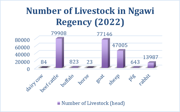
The potential for large amounts of unmanaged livestock waste to cause environmental pollution [16]. The amount of livestock and agricultural waste will depend on the number of livestock and the amount of agricultural yield in a region. In Ngawi Regency, livestock waste depends on the livestock population from Central Statistics Agency of Ngawi. Based on data from 2022, the largest livestock population is beef cattle with a total of 79,908 heads. Meanwhile, the smallest livestock population is horses with a total of 23 heads. Complete data on the livestock population (heads) in Ngawi Regency is shown in Figure 1.
Figure 1. Number of livestock in Ngawi Regency (2022)
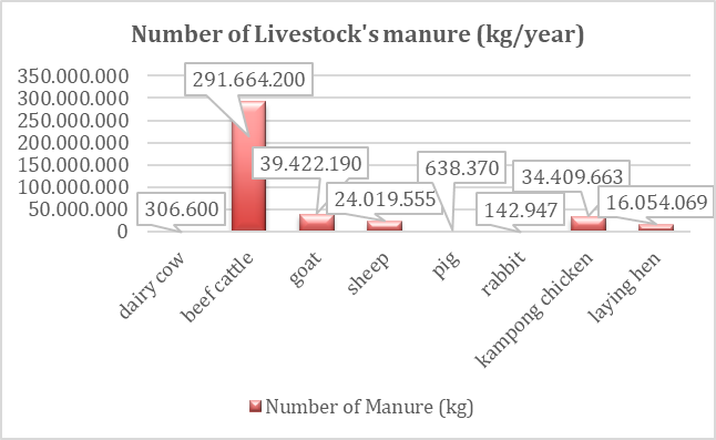
The presence of livestock populations in an area can directly produce significant amounts of livestock manure. This is because every animal excretes feces and urine as a result of its metabolism. Dairy cows can produce an average of 8-12 kg of feces per day, depending on the type of feed and the husbandry system [20]. If not managed properly, animal waste can cause various environmental impacts and potential public health risks if pathogens and antibiotic residues are released into the environment [21]. This is certainly an important challenge in areas with dense livestock populations [22]. Based on the results of studies and interviews, the amount of livestock manure produced in Ngawi Regency is illustrated in Figure 2.
Figure 2. Number of livestock manure
The amount of ruminant and poultry manure produced in Ngawi Regency can reach 468,468,975 kg/year. There are three areas with the highest potential for livestock waste production, namely Kendal, Ngawi, and Geneng subdistricts. Overall, Kendal subdistrict is the highest producer of livestock waste, amounting to 49,452,160 kg/day. In addition to producing fecal/manure waste, livestock also have the potential to produce abundant urine. Based on urine production analysis for cattle and buffalo, approximately 565,705 L of cattle and buffalo urine are produced, with an average production of 10 L/ST/day. Urine is also produced by goats and sheep. The total urine production of goats and sheep is estimated at 134,703.84 L, with an average urine production of 1.55 L/ST/day. Urine is also produced by rabbit farms. In 2022, the amount of urine produced by rabbits was around 562.97 L.
The food crop sector is one of the sectors that is beneficial to human life. However, this sector can produce waste that, if not managed properly, will have a negative impact. Increased development from urbanization and intensive agriculture poses a serious threat to ecosystem services [23]. Agricultural waste such as straw, plant litter, and crop processing waste can cause environmental problems as well as the loss of valuable resources [24]. Based on the document of potential utilization of agricultural waste in Ngawi Regency, wet and dry matter (DM) is obtained by multiplying fresh and dry production by the harvested area.
The total production of wet matter (WM) for one year from several subdistricts in Ngawi Regency amounted to 7,855,866 tons of WM (Table 1). The highest production of WM came from rice straw, which amounted to 4,982,472 tons. In terms of DM, the total waste production reached 2,939,634 tons of DM, with rice straw waste production in Ngawi Regency reaching 2,076,030 tons of DM, corn 833,896 tons of DM, peanuts 18,606 tons of DM, sweet potatoes 5,222 tons of DM, soybeans 2,916 tons DM, cassava 1,548 tons DM, and green beans 1,416 tons DM. A mixture of rice straw, corn straw, legume waste, cassava leaves, and sweet potatoes is sufficient to support basic needs and increase the production of ruminant livestock such as cows, buffalo, sheep, and goats. Rice and corn straw are often utilized during the harvest season.
Table 1. Production of wet matter (WM) and dry matter (DM) from each commodity in Ngawi Regency
|
Commodity |
Production of Wet Matter (ton) |
Production of Dry Matter (ton) |
|
Rice |
4,982,472 |
2,076,030 |
|
Corn |
1,395,314 |
833,896 |
|
Soybean |
4,278 |
2,916 |
|
Peanut |
36,538 |
18,606 |
|
Green beans |
6,500 |
1,416 |
|
Cassava |
13,584 |
1,548 |
|
Sweet potato |
23,472 |
5,222 |
3.2 Land suitability for agricultural waste disposal sites
MCA and GIS processing will indicate unsuitable and suitable land zones [25]. The selection of waste disposal sites must be done scientifically to avoid various aesthetic and environmental problems [26]. The landfilling method is often used among various waste management strategies (sea disposal, vermicomposting, incineration, etc.) because it is the most affordable and easy to implement method [27]. Physical, environmental, and socio-cultural considerations must be taken into account when selecting a disposal site because they can significantly affect the suitability analysis of the location and should not have a negative impact on the surrounding area [28]. The best way to determine a suitable final disposal site is to conduct a site suitability analysis that involves examining various factors to find the final disposal site [29].
There are several factors that are taken into consideration for disposal site locations, such as slope or land inclination. Areas with lower topography are often chosen as disposal sites, because areas with high elevations are not suitable for waste disposal due to higher transportation costs, high risk of landslides, and the presence of leachate [30]. Therefore, the suitability of waste disposal, especially agricultural waste, can be at a slope of 5°–7° as an ideal location [31]. In addition, Mitab et al. [32] recommended that areas with a slope of less than 5% be considered highly suitable as waste disposal sites. The suitability of disposal sites for agricultural waste in this study uses a slope parameter of less than 15%.
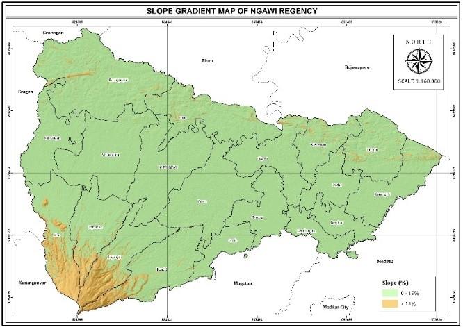
Most areas in Ngawi Regency have slopes ranging from 0 to 15% (Figure 3). Areas with slope gradients less than 15%, which are classified as suitable for agricultural waste disposal, cover approximately 129,075.77 ha (92.5%) of the total regency area. Some areas in Sine Subdistrict, Ngrambe Subdistrict, Jogorogo Subdistrict, and Kendal Subdistrict have slopes steeper than 15% and cover approximately 10,398.88 ha (7.5%). When viewed on a map, these subdistricts are located at the foot of Mount Lawu, which borders Karanganyar Regency and Magetan Regency.
Figure 3. Slope gradient map of Ngawi Regency
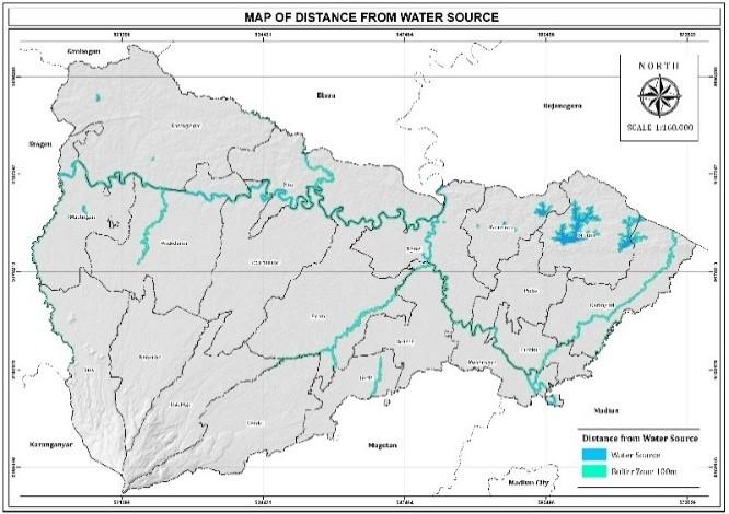
In addition to slope gradient, the distance to water sources must also be considered. The location of the waste disposal site must be placed far from lakes, rivers, and other surface water sources. For example, Mihiretie et al. [33] recommended a safe distance of 300 m between the disposal site and water sources. In this study, a safe distance of more than 100 m was set for the location of agricultural waste disposal. The spatial analysis of distance from water sources shows that most areas in Ngawi Regency comply with the minimum buffer requirement of 100 m (Figure 4). Areas classified as suitable (>100 m) cover approximately 132,934.46 ha (95.3%), while restricted buffer zones (<100 m) occupy 6,540.20 ha (4.7%).
Figure 4. Map of distance from water source
Landfills must also consider their location in relation to residential areas. The risk of pollution and public health issues such as pollution and infectious diseases can increase if landfills are located close to residential areas. The minimum distance that can be used for waste disposal is 1000 m from residential areas, and areas with a distance of > 1500 m from residential areas are more suitable [34]. In addition, the location of the landfill should be close to local roads to facilitate waste transportation. However, landfills should not be located near arterial roads so as not to disturb the aesthetics, so a minimum distance of 500 meters is required. In this study, the distance determined from residential areas was more than 500 meters.
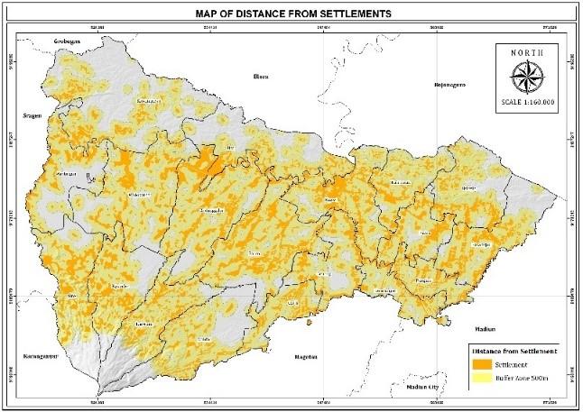
The residential buffer analysis reveals that settlement distribution is the most significant limiting factor in determining suitable locations for agricultural waste disposal. Areas located more than 500 m from residential settlements only cover 33,217.43 ha (23.8%), whereas areas within the restricted buffer zone (< 500 m) account for 106,257.23 ha (76.2%) of the total area (Figure 5). This indicates that the dense spatial distribution of rural settlements across Ngawi Regency substantially reduces the availability of land that meets social and environmental safety requirements.
Figure 5. Map of distance from residentials
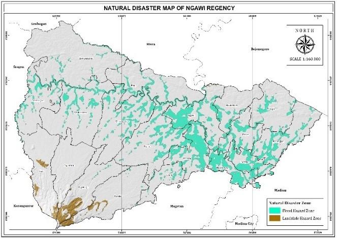
The location of agricultural waste disposal sites must also be outside flood-prone or landslide-prone areas. This is because waste can be carried away by floodwaters, causing damage. Waste management, including the creation of agricultural waste disposal sites, must be appropriate and include the reconstruction of areas that can prevent impacts on public health [35]. Many countries have adopted temporary disaster waste management sites (TDWMSs), but these must still take into account environmental changes such as flooding that occurs during and after a disaster. Indeed, natural disaster damage has the potential to affect the waste management system, which means that disposal sites should be located outside disaster areas [36]. In this study, the location of the agricultural waste disposal site is expected to be outside flood and landslide-prone zones (Figure 6).
Figure 6. Natural disaster map of Ngawi Regency
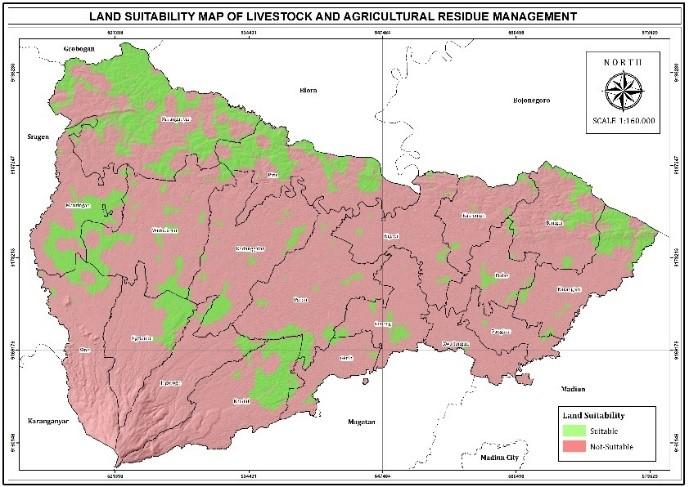
The results of the analysis of the suitability map for agricultural waste disposal sites were obtained by overlaying all the parameter maps that had been determined in Ngawi Regency. In general, disposal sites must comply with SNI Number 03-3241-1994, which in this study was adjusted to the Minister of Environment Regulation and Minister of Agriculture Regulation for agricultural waste disposal sites. The results of the interpretation of suitable locations for agricultural waste disposal sites in Ngawi Regency are shown in Figure 7. The disaster hazard analysis shows that areas classified as low hazard and suitable for waste disposal cover 116,114.37 ha (83.3%), while the area classified as unsuitable occupy 23,360.29 ha (16.7%).
Figure 7. Land suitability map of livestock and agricultural residue management
Based on the results of the analysis that has been carried out, the majority of areas in Ngawi Regency are not suitable for the placement of agricultural waste disposal sites. Approximately 82% of the area in this regency is unsuitable, while only about 18% of the area in this regency is suitable and has the potential to be used as a location for agricultural waste disposal sites. This map can be used as a basis for decision-making in line with the ultimate goal [11]. The data on the area of each subdistrict based on this analysis is outlined in Table 2.
Table 2. Land suitability area per subdistrict for agricultural waste disposal sites
|
District |
Suitable Land (Ha) |
Non Suitable Land (Ha) |
Total (Ha) |
|
Bringin |
1,166.42 |
5,605.70 |
6,772.11 |
|
Geneng |
452.95 |
4,977.29 |
5,430.24 |
|
Gerih |
259.43 |
3,122.21 |
3,381.64 |
|
Jogorogo |
345.06 |
6,759.05 |
7,104.11 |
|
Karanganyar |
7,125.28 |
8,711.43 |
15,836.71 |
|
Karangjati |
1,684.80 |
5,393.54 |
7,078.33 |
|
Kasreman |
227.48 |
4,449.73 |
4,677.22 |
|
Kedunggalar |
916.34 |
9,524.14 |
10,440.48 |
|
Kendal |
2,069.18 |
6,628.56 |
8,697.74 |
|
Kwadungan |
36.49 |
3,218.03 |
3,254.53 |
|
Mantingan |
2,293.08 |
4,504.27 |
6,797.35 |
|
Ngawi |
234.22 |
6,822.59 |
7,056.81 |
|
Ngrambe |
1,164.84 |
5,594.09 |
6,758.93 |
|
Padas |
347.07 |
3,881.59 |
4,228.66 |
|
Pangkur |
53.18 |
2,940.20 |
2,993.38 |
|
Paron |
946.60 |
9,658.62 |
10,605.22 |
|
Pitu |
3,120.50 |
5,859.71 |
8,980.21 |
|
Sine |
679.06 |
7,463.91 |
8,142.96 |
|
Widodaren |
2,087.31 |
9,150.67 |
11,237.98 |
|
Grand Total |
25,209.28 |
114,265.33 |
139,474.61 |
Based on the table showing the suitability and unsuitability of land in terms of its carrying capacity for disposal sites, it is known that the majority of areas in each region are unsuitable. Policy makers in Ngawi Regency can consider several subdistricts that have the potential to be agricultural waste disposal sites because they are the largest subdistricts with suitable land. These subdistricts include Karanganyar Subdistrict, Mantingan Subdistrict, and Pitu Subdistrict.
Landfill suitability in Ngawi is still lower than in several others. Several studies on landfill suitability using GIS and multi-criteria techniques report a wide range of suitable land proportions. For example, in the Burdur Lake Basin, Turkiye, approximately 18,14% are suitable and 22.38% are high suitability for landfill development [37]. In Kitwe, Zambia, 17.57% of the study area was classified as suitable and 40.74% of the study area was classified as most suitable for a landfill [38]. A case study of Alwar City, India revealed that 20.37% area was suitable [14].
The high proportion of unsuitable areas (82%) identified in Ngawi Regency is primarily influenced by a combination of environmental and socio-spatial constraints. Proximity to residential areas, water bodies, and road networks are key variables in determining a suitable landfill location, as locations close to residential areas raise social and health issues [39]. In the case of Ngawi, a 500-meter buffer zone from residential areas is very extensive in rural areas, rendering much of the land unsuitable. In addition, hydrological constraints further contribute to unsuitability, as areas located near rivers and surface water bodies are systematically excluded to minimize groundwater and surface water contamination risks [40]. Similar exclusion patterns were observed in landfill suitability assessments conducted in Greece and Ethiopia, where distance from water bodies and soil permeability were identified as critical limiting factors [40, 41].
Ngawi Regency has a large area of agricultural land, with more than 39% of its total area being agricultural land and the majority of its population working as farmers. This makes Ngawi Regency one of the major contributors to agriculture in East Java Province. This condition has the potential to generate large amounts of agricultural waste that requires management, one of which is the need for a suitable disposal site.
The model for selecting suitable locations for agricultural disposal sites is a process that involves various parameters such as slope gradient, distance to water sources, distance to residential areas, and location in areas that are not prone to disasters. This results in a more practical and comprehensive map model.
The analysis shows that the majority of areas in Ngawi Regency are unsuitable for use as agricultural waste disposal sites (82%). However, there are several subdistricts that have the largest areas with a status suitable for agricultural waste disposal sites, such as Karanganyar Subdistrict, Mantingan Subdistrict, and Pitu Subdistrict. It is recommended that the competent authorities review the parameters that have been determined to be more adaptive to developments in GIS-based MCA methods.
Future studies are recommended to integrate participatory approaches and socio-economic indicators, including public acceptance, land value, and infrastructure accessibility, to complement the environmental-based suitability assessment. The use of weighted multi-criteria decision-making methods, such as AHP or Fuzzy Logic, could provide more nuanced suitability rankings and allow comparative evaluation among alternative sites.
[1] Pienwisetkaew, T., Wongsiachia, S., Ketkaew, C. (2025). Technology adoption in smart agricultural waste management among farmers: The role of simplicity and gamification. Cleaner and Responsible Consumption, 19: 100344. https://doi.org/10.1016/j.clrc.2025.100344
[2] Alengebawy, A., Ran, Y., Osman, A.I., Jin, K., Samer, M., Ai, P. (2024). Anaerobic digestion of agricultural waste for biogas production and sustainable bioenergy recovery: A review. Environmental Chemistry Letters, 22(6): 2641-2668. https://doi.org/10.1007/s10311-024-01789-1
[3] Häner, J., Neradko, A., Weinrich, S., et al. (2025). Evaluation of pig farming residue as substrate for biomethane production via anaerobic digestion. Biomass Conversion and Biorefinery, 15(9): 14303-14323. https://doi.org/10.1007/s13399-024-06425-0
[4] He, X., He, L., Jiao, F., Zhang, K., He, X. (2024). A study of the effect of biochar additive on the manure–compost–soil process and its bacterial succession. Sustainability, 16(18): 7910. https://doi.org/10.3390/su16187910
[5] Rao, M.M., Botsa, S.M., Rao, T.P., Goddu, S.R., Vijayasanthi, C. (2024). A comprehensive review on agricultural waste production and onsite management with circular economy opportunities. Discover Sustainability, 5(1): 288. https://doi.org/10.1007/s43621-024-00492-z
[6] Lombardi, P., Todella, E. (2023). Multi-criteria decision analysis to evaluate sustainability and circularity in agricultural waste management. Sustainability, 15(20): 14878. https://doi.org/10.3390/su152014878
[7] Hisyam, A.Z. (2024). Analisis ketersediaan lahan pertanian terhadap peningkatan pendapatan di kabupaten ngawi. Jurnal Ilmiah Wahana Pendidikan, 10(19): 142-154. https://doi.org/10.5281/zenodo.14043101
[8] Akahoshi, K., Zusman, E., Hanaoka, T., et al. (2024). The prospects of controlling open burning of crop residues in Thailand: A quantitative assessment of implementation barriers and costs. Atmosphere, 15(11): 1309. https://doi.org/10.3390/atmos15111309
[9] Nguyen, D.M.T., Robinson, D.T., Zurbrügg, C., Nguyen, T.H.T., Dang, H.L., Pham, V.M. (2025). Strategic landfill site selection for sustainable waste management in Phu Yen Province, Vietnam using geospatial technologies. Ecological Informatics, 89: 103198. https://doi.org/10.1016/j.ecoinf.2025.103198
[10] Majid, M., Mir, B.A. (2021). Landfill site selection using GIS based multi criteria evaluation technique. A case study of Srinagar City, India. Environmental Challenges, 3: 100031. https://doi.org/10.1016/j.envc.2021.100031
[11] Saragih, D.F. (2023). Selection of solid waste landfill sites using the multi-criteria decision analysis method based on geographical information systems: A proposal modification of SNI 03-3241-1994. Jurnal Teknologi Lingkungan, 24(1): 89-97. https://doi.org/10.55981/jtl.2023.237
[12] Bartzas, G., Komnitsas, K. (2020). An integrated multi-criteria analysis for assessing sustainability of agricultural production at regional level. Information Processing in Agriculture, 7(2): 223-232. https://doi.org/10.1016/j.inpa.2019.09.005
[13] Bilgilioğlu, S.S. (2022). Site selection for radioactive waste disposal facility by GIS based multi criteria decision making. Annals of Nuclear Energy, 165: 108795. https://doi.org/10.1016/j.anucene.2021.108795
[14] Saini, M., Mohd, S. (2024). Integrating GIS and AHP for optimal landfill site selection: A case study of Alwar City, India. Revista Electronica De Veterinaria, 25(1): 3850-3863. https://doi.org/10.69980/redvet.v25i1.1857
[15] Macalam, F.J.T., Arreza, K.P., Magpantay, A.T., Rabaño, K.Y. (2023). Landfill site suitability assessment using geographic information system (GIS) and analytic hierarchy process (AHP) in Butuan City, Philippines. Journal of Environmental and Earth Sciences, 5(1): 95-107. https://doi.org/10.30564/jees.v5i1.5381
[16] Ministry of Public Works of the Republic of Indonesia. (2012). Peraturan Menteri Pekerjaan Umum Nomor 19/PRT/M/2012 tentang Pedoman Penataan Ruang Kawasan Sekitar Tempat Pemrosesan Akhir Sampah. https://peraturan.bpk.go.id/Details/160034/permen-pupr-no-19prtm2012-tahun-2012.
[17] Ministry of Public Works of the Republic of Indonesia. (2015). Peraturan Menteri Pekerjaan Umum dan Perumahan Rakyat Nomor 28/PRT/M/2015 tentang Penetapan Garis Sempadan Sungai dan Garis Sempadan Danau. https://peraturan.bpk.go.id/Details/159992/permen-pupr-no-28prtm2015-tahun-2015.
[18] Ministry of Public Works of the Republic of Indonesia. (2007). Peraturan Menteri Pekerjaan Umum Nomor 20/PRT/M/2007 tentang Pedoman Teknis Analisis Aspek Fisik dan Lingkungan, Ekonomi, serta Sosial Budaya dalam Penyusunan Rencana Tata Ruang. https://peraturan.bpk.go.id/Details/285846/permen-pupr-no-20-tahun-2007.
[19] Ministry of Public Works of the Republic of Indonesia. (2007). Undang-Undang Republik Indonesia Nomor 24 Tahun 2007 tentang Penanggulangan Bencana. https://peraturan.bpk.go.id/Details/39901/uu-no-24-tahun-2007.
[20] Arshad, R.N., Abdul-Malek, Z., Roobab, U., et al. (2022). Nonthermal food processing: A step towards a circular economy to meet the Sustainable Development Goals. Food Chemistry: X, 16: 100516. https://doi.org/10.1016/j.fochx.2022.100516
[21] Wu, Y., Li, Z., Fang, J. (2021). Environmental pollution and health hazards caused by animal agriculture manure. Journal of Environmental and Occupational Medicine, 38(11): 1284-1290. https://doi.org/10.13213/j.cnki.jeom.2021.21133
[22] Dell, C.J., Baker, J.M., Spiegal, S., et al. (2022). Challenges and opportunities for manureshed management across U.S. dairy systems: Case studies from four regions. Journal of Environmental Quality, 51(4): 521-539. https://doi.org/10.1002/jeq2.20341
[23] Wang, Y., Deng, Y., Liu, X., Chang, J. (2022). Adsorption behaviors and reduction strategies of heavy metals in struvite recovered from swine wastewater. Chemical Engineering Journal, 437: 135288. https://doi.org/10.1016/j.cej.2022.135288
[24] Duque-Acevedo, M., Belmonte-Ureña, L.J., Cortés-García, F.J., Camacho-Ferre, F. (2020). Agricultural waste: Review of the evolution, approaches and perspectives on alternative uses. Global Ecology and Conservation, 22: e00902. https://doi.org/10.1016/j.gecco.2020.e00902
[25] Ampofo, S., Issifu, J.S., Kusibu, M.M., Mohammed, A.S., Adiali, F. (2023). Selection of the final solid waste disposal site in the Bolgatanga municipality of Ghana using analytical hierarchy process (AHP) and multi-criteria evaluation (MCE). Heliyon, 9(8): e18558. https://doi.org/10.1016/j.heliyon.2023.e18558
[26] Van Thanh, N. (2022). Optimal waste-to-energy strategy assisted by fuzzy MCDM model for sustainable solid waste management. Sustainability, 14(11): 6565. https://doi.org/10.3390/su14116565
[27] Priti, Mandal, K. (2019). Review on evolution of municipal solid waste management in India: Practices, challenges and policy implications. Journal of Material Cycles and Waste Management, 21(6): 1263-1279. https://doi.org/10.1007/s10163-019-00880-y
[28] Sadhasivam, N., Sheik Mohideen, A.R., Alankar, B. (2020). Optimisation of landfill sites for solid waste disposal in Thiruverumbur taluk of Tiruchirappalli district, India. Environmental Earth Sciences, 79(23): 522. https://doi.org/10.1007/s12665-020-09264-0
[29] Zhao, F., Wu, H., Zhu, S., et al. (2023). Material stock analysis of urban road from nighttime light data based on a bottom-up approach. Environmental Research, 228: 115902. https://doi.org/10.1016/j.envres.2023.115902
[30] Zeleke, J.A., Wedajo, G.K. (2025). Geospatial technologies and multi-criteria decision making based-urban solid waste disposal suitable site selection: The case of Assosa town, Ethiopia. Cleaner Waste Systems, 11: 100284. https://doi.org/10.1016/j.clwas.2025.100284
[31] Asefa, E.M., Damtew, Y.T., Barasa, K.B. (2021). Landfill site selection using GIS based multicriteria evaluation technique in Harar City, Eastern Ethiopia. Environmental Health Insights, 15: 11786302211053174. https://doi.org/10.1177/11786302211053174
[32] Mitab, B.T., Hamdoon, R.M., Sayl, K.N. (2023). Assessing potential landfill sites using GIS and remote sensing techniques: A case study in Kirkuk, Iraq. International Journal of Design and Nature and Ecodynamics, 18(3): 643-652. https://doi.org/10.18280/ijdne.180316
[33] Mihiretie, A. (2022). Suitable solid waste disposal site selection using geographical information system: A case of Debre Markos town, Ethiopia. International Journal of Environment and Geoinformatics, 9(2): 1-8. https://doi.org/10.30897/ijegeo.784087
[34] Hailu, Y., Hanchiso, T., Bereta, A. (2019). Municipal solid waste suitable disposal site selection, case study, Wolkite Town, Ethiopia. International Journal of Environmental Sciences & Natural Resources, 20(4): 126-131. https://doi.org/10.19080/ijesnr.2019.20.556044
[35] Lee, Y.H., Kim, Y.C., Lee, H.K. (2022). Framework for selection of temporary disaster waste management sites for post-flood recovery in Seoul, South Korea. International Journal of Disaster Risk Reduction, 71: 102832. https://doi.org/10.1016/j.ijdrr.2022.102832
[36] Phonphoton, N., Pharino, C. (2019). A system dynamics modeling to evaluate flooding impacts on municipal solid waste management services. Waste Management, 87: 525-536. https://doi.org/10.1016/j.wasman.2019.02.036
[37] Soyaslan, İ.İ. (2025). Landfill site suitability analysis for sustainable solid waste management using AHP and GIS in Burdur Lake Basin, Türkiye. MethodsX, 15: 103555. https://doi.org/10.1016/j.mex.2025.103555
[38] Mvula, R.L.S., Mundike, J., Nguvulu, A. (2023). Spatial suitability analysis for site selection of municipal solid waste landfill using hybrid GIS and MCDA approach: The case of Kitwe, Zambia. Scientific African, 21: e01885. https://doi.org/10.1016/j.sciaf.2023.e01885
[39] Chafiq, T., Hmamou, M., Ouhammou, I., Labriki, A., ElHabchi, M., Raji, M. (2023). Geographic analysis of landfill suitability in Fez, Morocco: A multi-criteria approach. Discover Environment, 1(1): 16. https://doi.org/10.1007/s44274-023-00016-y
[40] Parastatidou, E., Voudouris, K., Kazakis, N. (2024). Determination of site suitability for a sanitary landfill using GIS and Boolean logic: The case of the regional unit of Chalkidiki, Northern Greece. Environments, 11(8): 175. https://doi.org/10.3390/environments11080175
[41] Sisay, T., Teku, D., Abebaw, E. (2025). Solid waste disposal site selection using GIS and the analytic hierarchy process model: A case study conducted in Gimba Town, Northeastern Ethiopia. Frontiers in Sustainability, 6: 1528851. https://doi.org/10.3389/frsus.2025.1528851