Imam Indratno* | Rizky Abdulharis | Irland Fardani | Gina Puspitasari Rochman | Sena Hari Kuntoro | Aldy Pratama | Deshinta Arrova Dewi
© 2026 The authors. This article is published by IIETA and is licensed under the CC BY 4.0 license (http://creativecommons.org/licenses/by/4.0/).
OPEN ACCESS
Translating planning theory into operational decision-support systems remains a critical challenge in traditional settlements where cultural legitimacy, social consensus, and environmental conditions are deeply interconnected. Existing spatial models typically treat these dimensions as independent variables, failing to capture the non-compensatory hierarchy of customary governance. This study develops the Transcendental Integrative System (TIS), a Bayesian Hierarchical Gating Model in which cultural legitimacy functions as a deterministic gate, social consensus is represented as a conditional posterior probability, and physical feasibility is evaluated only after cultural and social conditions are satisfied. A convergent mixed-method approach was applied in Kampung Adat Kuta, West Java, Indonesia, combining participatory geographic information system (PGIS), in-depth interviews with 25 key informants, qualitative coding with inter-coder reliability of 0.82, and retrospective classification validation across 115 spatial units. The model achieved an accuracy of 0.80 and an F1-score of 0.86, significantly outperforming a physical-suitability-only baseline (accuracy 0.62) and a standard Naïve Bayes benchmark (accuracy 0.74). These results demonstrate that sustainable spatial decisions in traditional settlements emerge from a structured, auditable hierarchy rather than from technical optimisation alone. The study contributes a reproducible computational architecture that bridges rational, communicative, and phenomenological planning paradigms.
Bayesian Hierarchical Gating, cultural sustainability, indigenous planning, spatial decision-making, Transcendental Integrative System, process innovation
Sustainable spatial planning increasingly requires decision-support systems that integrate ecological processes, socio-cultural values, and governance institutions within a coherent analytical framework [1, 2]. This requirement highlights the inherent politics of sustainability, where transformations are viewed not as manageable technical shifts but as processes drawing on 'unruly politics' and the integration of diverse forms of knowledge [3]. In traditional settlements, spatial organization is shaped not only by environmental suitability but also by ritual obligations, customary authority, sacred boundaries, and collective memory [4, 5]. These conditions demand planning models that can account simultaneously for measurable spatial variables and culturally embedded rules.
Recent advances in geographic information system (GIS), GeoAI, and Bayesian spatial modelling have improved the capacity of planning systems to combine heterogeneous datasets and represent uncertainty [6, 7]. These developments in geoAI facilitate the processing of increasingly diverse and complex data sources, yet they often rely on 'black box' machine learning methods that lack transparency regarding the specific purposes and inherent qualitative properties of the geographic space they analyze [8].
However, many computational tools remain technocentric because they prioritize optimisation and standardized data while giving limited attention to subjective experience, customary knowledge, and social legitimacy [9, 10]. This is particularly problematic in traditional settlements where culturally prohibited spaces cannot be treated as ordinary suitability variables.
Planning theory has long addressed the limitations of technical rationality. Rational-comprehensive planning offers analytical rigor, communicative planning emphasizes deliberation and consensus, and phenomenological perspectives foreground lived experience, meaning, and place attachment [11-13]. Yet these paradigms remain weakly connected at the operational level: participation does not automatically become decision authority, and cultural meaning is often acknowledged conceptually without being translated into reproducible decision rules [14, 15].
The unresolved gap is therefore not whether cultural values matter, but how they can be transformed into an explicit, traceable, and testable spatial decision mechanism. Participatory GIS and participatory Bayesian networks show that local knowledge can be spatialized and linked to probabilistic reasoning, but a clear architecture for representing non-compensatory customary restrictions remains absent [16, 17]. This study addresses that gap by developing and validating a culturally grounded Bayesian decision-support model.
Kampung Adat Kuta, a customary village (kampung adat) in Ciamis Regency, West Java, provides a critical case because its spatial governance combines customary authority, sacred zoning, social deliberation, and environmental constraints. In this context, cultural permissibility precedes social acceptance and physical evaluation. A spatial unit that violates pamali or overlaps with a sacred zone is rejected regardless of its technical suitability, making the case suitable for testing a hierarchical gating model.
This study develops the Transcendental Integrative System (TIS) as an operational extension of Transcendental Integrative Planning (TIP). TIP provides the conceptual ontology, TIS translates it into an operational architecture, and the Bayesian Hierarchical Gating Model functions as the computational engine. Naïve Bayes is used only as a benchmark because its conditional-independence assumption cannot represent the sequential dependency among value, communication, and physical variables [18, 19].
The central research question is: how can cultural legitimacy, social consensus, and physical feasibility be operationalised into a Bayesian Hierarchical Gating Model for spatial decision-making in Kampung Adat Kuta? The study aims to identify the value, communication, and physical dimensions of spatial decision-making; operationalise them into computable variables; and evaluate the model by comparing predicted decisions with observed spatial decisions across 115 spatial units.
The novelty of the study lies in three related contributions. First, cultural legitimacy is formalized as a deterministic Value Gate rather than a compensatory weight. Second, social consensus is represented as a conditional posterior probability. Third, physical feasibility is evaluated conditionally only after cultural and social legitimacy are satisfied. This sequential structure makes the model fully auditable and aligns computational planning with culturally grounded decision authority [17, 20].
The conceptual framework is organized around the conversion of fragmented planning paradigms into an operational decision mechanism. Rational-comprehensive planning, communicative planning, and phenomenological planning each contribute a different logic of decision-making, but they must be translated into ordered computational functions to become usable in a decision-support system [11-13].
The proposed framework therefore distinguishes three levels: TIP as the conceptual foundation, TIS as the operational architecture, and the Bayesian Hierarchical Gating Model as the computational mechanism. This distinction is necessary to avoid treating cultural values as generic variables and to preserve the sequential priority of customary legitimacy, social consensus, and physical feasibility [16, 17, 20].
2.1 Fragmented planning paradigms and the missing mechanism
Contemporary planning systems face a fundamental limitation in translating cultural values, social communication, and physical conditions into a reproducible decision-making framework [1, 2]. While planning theory has evolved through rational-comprehensive, communicative, and phenomenological paradigms, these approaches often remain fragmented in practice [11, 12].
Rational planning provides analytical rigor and spatial optimisation but tends to neglect cultural meaning and contextual variability. Communicative planning emphasises participation and consensus-building, yet empirical studies show that participation does not automatically translate into decision legitimacy or authority. Meanwhile, phenomenological and postmodern approaches highlight spatial meaning, identity, and lived experience, but remain difficult to operationalise into structured decision systems [5-7, 16].
This fragmentation results in a persistent operational gap: value-based knowledge and participatory processes are frequently discussed normatively, but they are rarely encoded as actionable and legitimate spatial decision rules. The gap is most visible in traditional settlement contexts where ritual validation, social consensus, and ecological constraints operate simultaneously [5, 17, 21].
2.2 Conceptual integration in Transcendental Integrative Planning
TIP is used as the conceptual foundation for integrating value, communication, and physical dimensions within a relational ontology of planning [4, 11]. TIP extends existing planning paradigms by incorporating transcendental consciousness, understood operationally as the collective cultural, ethical, and cosmological awareness that guides spatial decision-making-not as psychological consciousness, but as layered evaluative awareness represented through the Value (V), Communication (C), and Physical (P) layers [5, 22].
In traditional settlements such as Kampung Adat Kuta, spatial organization is structured through sacred zoning, ritual authority, and customary rules, reflecting a system where legitimacy is determined through transcendental validation rather than purely technical criteria. This demonstrates that planning operates not only as a technical or communicative process but as a culturally embedded system of meaning and legitimacy.
However, while TIP provides a strong conceptual integration, it remains limited at the operational level. The framework does not yet offer a structured mechanism to translate transcendental values, social interactions, and physical conditions into a formal decision-support system. This limitation reinforces the need for an operational model that can bridge theory and system. To provide full transparency and respond directly to reviewer concerns, Table 1 presents the operational definitions of the three core concepts used throughout this study. These definitions clarify that the concepts are not treated as abstract philosophical notions but as measurable, coded, and computationally integrable variables.
To ensure full transparency in the computational process, the core concepts of TIS are operationalized into measurable variables. The qualitative data for these variables were gathered from 25 key informants, whose profiles and data objectives are detailed in Table 1. Within this framework, transcendental value is defined as the cultural-cosmological order guiding spatial permissibility. Operationally, it represents the cultural acceptability of each spatial unit as determined by customary authority, measured through proxies such as sacred restrictions (Leuweung Larangan), pamali (prohibitions), and ritual approval (nepus). These are encoded using a binary rule where V = 0 denotes restricted zones and V = 1 indicates permissible areas.
Furthermore, consciousness is interpreted as a structured spatial governance awareness rather than a psychological state. It is expressed through three sequential evaluative layers—Value (V), Communication (C), and Physical (P)—where outputs are encoded respectively as binary exclusion rules, Bayesian posteriors, and conditional physical posteriors. Finally, legitimacy represents the recognition that a spatial decision is culturally, socially, and physically acceptable. It is defined as the final decision status produced after the complete V→C→P evaluation. A spatial unit is only classified as 'Accepted' if it passes the Value Gate (V=1) and meets the required probability thresholds for both social consensus and physical feasibility; otherwise, it is 'Rejected'.
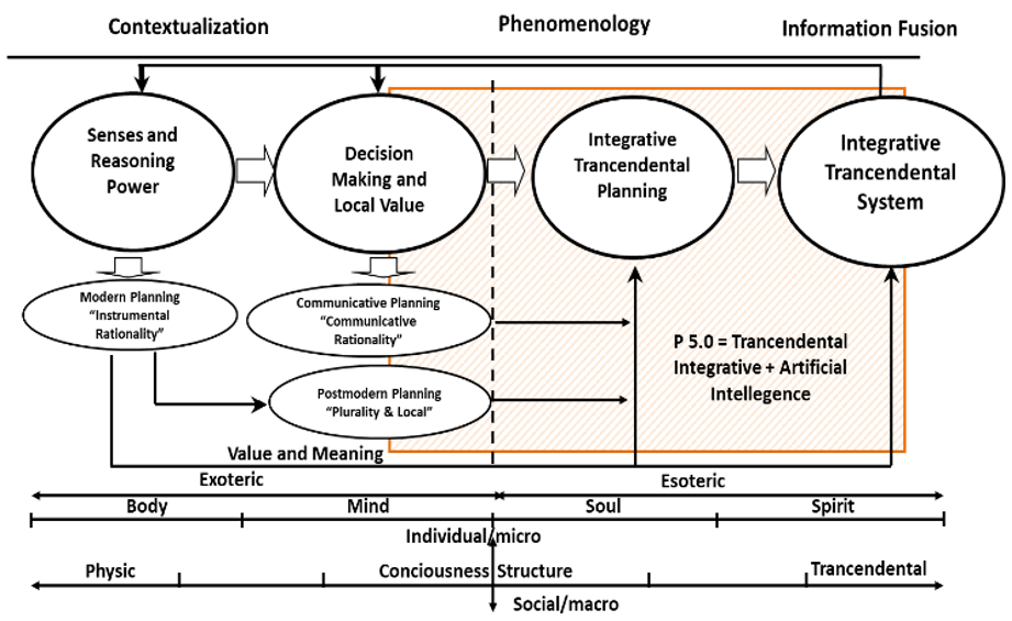
Figure 1. Transcendental Integrative Planning (TIP) framework
Figure 1 illustrates the conceptual structure of TIP, showing the relational interaction between transcendental values, social communication, and physical-spatial conditions as the foundation of culturally grounded planning systems.
Table 1. Informant profile and data objectives
|
Informant Group |
n |
Selection Criterion |
Data Objective |
|
Kuncen / ritual custodian |
1 |
Authority on pamali and sacred boundaries |
Value Gate rules |
|
Sesepuh Adat / elders |
2 |
Historical and cosmological spatial knowledge |
Ritual and boundary validation |
|
Community figures |
7 |
Actors in village decision-making |
Consensus and conflict data |
|
Villagers / households |
12 |
Users of the spatial units |
Lived experience and acceptance |
|
Village officials |
3 |
Formal local governance actors |
Administrative alignment |
|
Total |
25 |
Purposive sampling |
Multi-layer validation |
2.3 Probabilistic planning systems and their limitations
Advancements in artificial intelligence and spatial modelling have introduced new capabilities for predictive analysis and decision-support modelling [6, 7]. Bayesian inference is particularly relevant because it can integrate prior knowledge with observed evidence while representing uncertainty among heterogeneous variables [7, 23].
Reviews of Bayesian networks for spatial data confirm their capacity to represent uncertainty and interdependencies among heterogeneous variables, making them structurally suited to multi-layered planning environments [7, 17]. Applications in blue-green infrastructure selection further demonstrate that Bayesian models can guide context-sensitive environmental decisions under dynamic conditions [6]. This positions Bayesian spatial modelling as a methodologically rigorous foundation for integrating diverse knowledge forms within a decision-support architecture.
Nevertheless, existing AI-based planning systems remain largely constrained to quantifiable variables and often fail to incorporate cultural, symbolic, and transcendental dimensions [9, 10]. The assumption of conditional independence in models such as Naïve Bayes further limits their applicability in socio-cultural contexts, where decision variables are inherently interdependent and relational [18, 19]. In the context of traditional settlements such as Kampung Adat Kuta, spatial decision variables-including transcendental values, social consensus, and physical conditions-are inherently interdependent and relational, making the standard Naïve Bayes assumption architecturally insufficient to capture local spatial logic [17, 24]. Therefore, this study does not treat Naïve Bayes as a full representation of the complex decision-making structure. Instead, standard Naïve Bayes is employed strictly as a simplified probabilistic benchmark to evaluate the performance gains of the proposed hierarchical architecture [17, 18].
Computational advances in spatial modelling realize their full analytical potential only when integrated with participatory and place-based knowledge systems. Public Participation GIS research demonstrates that map-based participation enables communities to contribute both geographic and experiential information that conventional datasets routinely overlook, effectively bridging subjective spatial experience with objective GIS data [16, 17]. This integration is particularly consequential for frameworks in which value and communication layers depend on local perceptions, customary boundaries, and collective validation processes that cannot be adequately captured through remote sensing or administrative records alone [16, 24].
As a result, these systems frequently produce technically optimised outcomes that lack cultural legitimacy, highlighting the need for an integrative model that can embed qualitative and value-based dimensions into computational planning systems.
2.4 Transcendental Integrative System as a hierarchical Bayesian decision mechanism
To overcome these limitations, this study develops the TIS as an operational extension of TIP. TIS functions as a mechanism-based framework that translates conceptual integration into a probabilistic decision-making system.
The system is structured around three interdependent dimensions:
Unlike conventional models, TIS organizes these dimensions hierarchically. The value dimension functions as a gatekeeping mechanism that determines whether a spatial decision is culturally permissible. The communication dimension translates participation into measurable social legitimacy. The physical dimension evaluates environmental feasibility based on empirical conditions.
These dimensions are integrated through a Bayesian Hierarchical Gating model, in which the value layer (P(V)) functions as a deterministic primary gate; the communication layer (P(C∣V)) evaluates social legitimacy conditionally for units that pass the value gate; and the physical layer (P(P∣C,V)) assesses environmental feasibility only after cultural and social conditions are satisfied. This hierarchical gating structure ensures that cultural prohibitions cannot be offset by high technical scores, providing a more transparent and traceable decision-support architecture. This approach allows planning systems to operate under uncertainty while maintaining alignment with cultural values and ecological constraints.

Figure 2. Transcendental Integrative System framework
Figure 2 illustrates the operational structure of the TIS, showing the hierarchical integration of value, communication, and physical dimensions through a probabilistic mechanism, where cultural legitimacy guides social validation and environmental feasibility within a unified decision-support system.
2.5 Theoretical contribution
The integration of TIP and TIS contributes to planning theory and practice by linking rational analysis, communicative legitimacy, and phenomenological meaning in a single operational architecture [11, 12]. It also contributes methodologically by making the transformation of customary knowledge into computational variables transparent, auditable, and open to community validation [16, 17].
By transforming TIP into an operational system, this study redefines planning as a relational and adaptive process, where decision-making emerges from the interaction between data, values, and social processes. This provides a robust foundation for developing planning systems that are both technically effective and culturally legitimate in traditional and sustainability-oriented contexts.
The research design adopts a phenomenological-computational approach to bridge qualitative spatial knowledge and structured decision systems. This orientation is methodologically supported by mixed-method research design, participatory GIS, and participatory Bayesian modelling because each enables local knowledge, spatial evidence, and probabilistic reasoning to be integrated in a traceable workflow [16, 17, 25].
Data collection is stratified across three domains: value, communication, and physical feasibility. Participatory mapping is central to this design because it records geographic and non-geographic knowledge that conventional spatial datasets often miss, while customary governance studies show that ritual norms and local authority can operate as binding spatial rules rather than informal preferences [16, 21, 26].
The Bayesian-spatial modelling approach is justified by its capacity to integrate heterogeneous evidence, represent uncertainty, and preserve dependencies among spatial, social, and cultural variables [6, 7, 17]. The hierarchical structure of the model ensures that spatial outputs are conditioned by cultural and social filters before environmental feasibility is assessed, reflecting the decision logic of customary spatial governance [21, 26, 27].
3.1 Research design and epistemological foundation
A convergent mixed-method design is appropriate because the study combines qualitative community knowledge, participatory mapping, and quantitative spatial analysis [16, 17]. This design captures the cultural depth of customary legitimacy while providing a reproducible structure for modelling value, communication, and physical feasibility.
This integration aligns with the framework of TIP, which conceptualizes planning as a relational process shaped by value, communication, and physical conditions. To operationalise this conceptual framework, the study develops the TIS, enabling the translation of these dimensions into a probabilistic decision-support model.
The model is designed as a decision-support system rather than an autonomous replacement for customary authority. Its purpose is to make culturally grounded spatial logic explicit and auditable while ensuring that final legitimacy remains accountable to community validation [16, 17].
3.2 Case selection and contextual justification
The empirical case of Kampung Adat Kuta, West Java, Indonesia, is selected as a critical case representing a traditional village system with strong customary governance and transcendental spatial logic. Spatial decision-making in this context is regulated through ritual validation, sacred zoning, and collective deliberation, making it highly suitable for examining the interaction between value, communication, and physical dimensions.
The selection follows a theoretical sampling logic, where the case represents an extreme or information-rich example of culturally embedded planning. This allows the study to test the applicability of the TIP–TIS framework in a context where the “missing mechanism” between values and operational decisions is most visible.
3.3 Data collection and informant profile
To strengthen reproducibility, the qualitative component was organized through a structured informant profile. Data were collected from 25 key informants selected purposively according to their authority, knowledge, and direct involvement in Kampung Adat Kuta spatial practices. The informant composition was designed to capture customary authority, collective memory, social legitimacy, household experience, and formal administrative perspectives.
Data collection was organized into three domains corresponding to the TIS layers: value data were obtained from ritual practices, sacred norms, and customary restrictions; communication data from deliberation, participatory mapping, and stakeholder interaction; and physical data from spatial, environmental, and geophysical conditions. This structure ensured that symbolic and transcendental knowledge could be transformed into structured variables without detaching them from their local context [16].
3.4 Operationalization of the Value Gate and consciousness framework
To operationalize the Value Gate as a deterministic constraint, sacred zones and restricted spatial units were identified through direct consultation with customary authorities. The Kuncen and Sesepuh Adat delineated Leuweung Larangan (sacred forest), sacred water-source areas, and pamali (prohibited) zones on high-resolution base maps during participatory mapping sessions. This narrative and ritual knowledge was subsequently converted into spatial data and linked to the 115 candidate spatial units. The operational dimensions and proxy indicators for this process are presented in Table 2, while the specific qualitative coding scheme for these variables is detailed in Table 3.
Table 2. Operationalization of Transcendental Integrative System (TIS) variables
|
Layer |
Operational Dimension |
Proxy / Indicator |
Coding / Scale |
|
Value |
Cultural legitimacy |
Sacred restriction; pamali; ritual approval |
V = 0 restricted; V = 1 permissible |
|
Communication |
Social legitimacy |
Consensus; conflict; institutional alignment |
Likert 1-5; posterior P(C|V) |
|
Physical |
Environmental feasibility |
Slope; land cover; hydrology; flood hazard |
Suitability class; posterior P(P|C,V) |
Table 3. Qualitative coding scheme for Transcendental Integrative System (TIS) variables
|
Code |
Indicator |
Coding / Scale |
Layer |
|
V1 Sacred restriction |
Overlap with Leuweung Larangan or sacred water-source zone |
0 = restricted; 1 = permissible |
Value |
|
V2 Pamali |
Explicit customary prohibition confirmed by Kuncen/Sesepuh |
0 = prohibited; 1 = allowed |
Value |
|
V3 Ritual approval |
Nepus or customary validation outcome |
0 = not approved; 1 = approved |
Value |
|
C1 Consensus |
Agreement in FGD and deliberative forum |
Likert 1-5 -> posterior |
Communication |
|
C2 Conflict |
Boundary dispute or dissenting voice |
1 = conflict; 0 = no conflict |
Communication |
|
P1-P4 Physical variables |
Slope, land cover, hydrology, flood hazard |
Suitability class -> posterior |
Physical |
The Value Gate is formulated not as a probabilistic score, but as a binary exclusion rule; consequently, units coded as V = 0 are excluded from all subsequent computation regardless of their communication or physical scores. Spatial units assigned a code of V = 0 represent restricted, sacred, or prohibited areas that are not ritually approved; these are automatically classified as rejected and do not proceed to subsequent layers of the model. Conversely, spatial units coded as V = 1 are considered permissible, neutral, or ritually approved, allowing them to proceed to the Communication and Physical layers for further evaluation.
To maintain ethical alignment with indigenous sovereignty, a Community Validation Protocol was implemented. If the model predicts a location as accepted but customary authority deems it restricted during the validation phase, the customary decision is treated as the final cultural constraint. In such instances, the discrepancy is documented in a log, and the Value Gate coding is recalibrated to preserve the role of TIS as a culturally grounded decision-support tool rather than an autonomous decision-maker.
Figure 3 illustrates the flow of data collection, transformation, and integration across value, communication, and physical layers, leading to probabilistic decision outputs.

Figure 3. Spatial decision-making process in the Transcendental Integrative System
3.5 Qualitative coding scheme and inter-coder reliability
The transformation of narrative interview data, focus group discussion (FGD) notes, and participatory mapping records into computational variables followed a deductive-inductive coding procedure, as structured within the multi-stage participatory GIS workflow presented in Table 4. Deductive codes were derived directly from the TIS framework, while inductive codes were employed to capture field-specific expressions of customary restriction, boundary disagreements, and localized environmental concerns.
Table 4. Participatory geographic information system (PGIS) workflow and outputs
|
Stage |
Input and Actors |
Process |
Output |
|
Unit identification |
Base maps; research team and residents |
Delineate recognizable local spatial units |
115 coded units |
|
Sacred mapping |
Kuncen, Sesepuh, base maps |
Delineate Leuweung Larangan, pamali, sacred water zones |
Value Gate map |
|
Social scoring |
FGD, community figures, households, officials |
Score consensus and record disagreement |
Communication matrix |
|
Physical overlay |
Slope, land cover, hydrology, flood hazard |
GIS overlay and suitability classification |
Physical matrix |
|
Integration |
V, C, and P variables |
Bayesian Hierarchical Gating |
Predicted decision |
|
Validation |
Customary leaders and community representatives |
Map checking and nepus verification |
Validated dataset |
To ensure the reliability of this qualitative-to-quantitative transformation, two independent coders processed the interview transcripts and mapping records. Inter-coder reliability was measured using Cohen’s Kappa, producing a score of 0.82, which indicates a high level of consistency and algorithmic readiness before the variables were integrated into the Bayesian model. Any identified disagreements between coders were resolved through deliberative discussion and meticulous cross-checking with original field notes and participatory mapping outputs to ensure the model accurately reflected indigenous spatial logic.
3.6 Participatory geographic information system workflow and probability estimation
The spatial data for the 115 units were generated through a multi-stage participatory GIS workflow. The process was designed to connect qualitative indigenous knowledge with quantitative spatial modelling and to make each transformation step traceable.
The Bayesian Hierarchical Gating model estimates the final spatial decision through the probability chain P(D) = P(V) × P(C|V) × P(P|C,V), where P(V) represents cultural permissibility as a binary gate, P(C|V) represents social legitimacy for units that pass the Value Gate, and P(P|C,V) represents physical feasibility conditioned on cultural and social approval. To ensure full reproducibility, Table 5 presents three concrete illustrative cases showing how each probability is estimated for individual spatial units.
Table 5. Probability estimation procedure
|
Term |
Data Source |
Estimation Procedure |
Output |
|
P(V) |
Sacred map, pamali coding, nepus |
Binary coding by customary authority |
Value Gate status |
|
P(C|V) |
FGD scores and conflict notes |
Likert scores converted to posterior for V = 1 units |
Communication posterior |
|
P (P|C, V) |
Slope, land cover, hydrology, flood hazard |
GIS classes converted to conditional posterior |
Physical posterior |
|
P(D) |
Integrated V, C, P |
Sequential multiplication and threshold classification |
Accepted / rejected |
|
Physical baseline |
Physical variables only |
Classification without V and C layers |
Baseline accuracy |
|
Naïve Bayes baseline |
Same V, C, P variables |
Conditional independence among predictors |
Benchmark accuracy |
The operational logic of the Bayesian Hierarchical Gating Model is demonstrated through three representative cases of probability estimation presented in Table 5. These examples illustrate the sequential probability chain P(D) = P(V)×P(C∣V)×P(P∣C,V). For Unit SU-01, the unit successfully passed the Value Gate (V = 1). Its Likert consensus score of 5/5 was converted to a communication posterior of 0.95 using frequency-based calibration derived from FGD records and historical deliberation data.
Furthermore, SU-01 was assigned a physical class of high feasibility based on a slope gradient of less than 8%, a transitional zone land cover, low hydrological risk, and flood hazard category class I. This physical profile was converted to a physical posterior of 0.78 through a conditional lookup table derived from GIS suitability classification, resulting in a combined probability of 0.74 and a final Accepted status. In contrast, Unit SU-02 illustrates the deterministic nature of the cultural filter within TIS. Because the unit was identified as being in a sacred or restricted zone (V = 0), the computational process was terminated immediately. Consequently, consensus and physical scores were not computed, yielding a combined probability of 0.00 and an automatic Rejected status at the Value Gate.
Finally, Unit SU-03 represents a culturally permissible unit (V = 1) that failed to reach the acceptance threshold due to social and physical constraints. A consensus score of 3/5 produced a lower communication posterior of 0.65, reflecting recorded boundary disagreements among stakeholders. Combined with a low physical feasibility posterior of 0.42, the final probability P(D) was calculated at 0.27, falling below the classification threshold and resulting in a Rejected decision. This hierarchical sequence ensures that final spatial recommendations are grounded in both indigenous legitimacy and biophysical feasibility.
Figure 4 presents the probabilistic interaction between value, communication, and physical layers, demonstrating how decision outcomes are derived through conditional dependencies.

Figure 4. Bayesian integration structure of Transcendental Integrative System (TIS)
3.7 Model and community validation protocols
Model validation was conducted through retrospective classification validation across all 115 spatial units, comparing model-predicted decisions with observed spatial decision outcomes. The primary metric is Accuracy, defined as the proportion of correct matches between model predictions and field observations. Precision, Recall, and F1-score were also calculated. Model performance was compared with two baselines: a physical-suitability-only model and a standard Naïve Bayes benchmark using the same V, C, and P variables but treating them as conditionally independent predictors [20, 21].
A structured community validation protocol was implemented through a dual-track verification process, as detailed in Table 6. First, a technical-social check was performed using participatory map-based verification involving customary leaders, village officials, community figures, and representative residents. This stage allowed for the cross-checking of spatial boundaries, social consensus scores, and physical suitability assessments. Second, a transcendental legitimacy check was conducted through the Nepus ritual forum with the Kuncen and Sesepuh Adat to confirm whether any model outputs violated sacred zones or pamali (customary prohibitions).
Table 6. Community validation protocol
|
Validation Stage |
Participants |
Method and Documentation |
Expected Output |
|
Technical-social check |
Village officials, residents, community figures |
PGIS checking, FGD logs, attendance list |
Refined boundaries and consensus scores |
|
Transcendental legitimacy |
Kuncen and Sesepuh Adat |
Nepus forum and customary statement |
Final Value Gate pass/fail status |
|
Discrepancy handling |
Customary leaders and research team |
Compare model output with customary decision; discrepancy log |
Customary decision treated as final constraint |
To maintain ethical alignment with indigenous sovereignty, the protocol included a specific procedure for discrepancy handling. If a model prediction conflicted with customary authority during validation, the customary decision was treated as the final cultural constraint. In such instances, the conflict was documented in a discrepancy log, and the Value Gate coding was recalibrated accordingly to ensure the TIS remains a culturally grounded decision-support tool rather than an autonomous decision-maker.
3.8 Ethical and epistemological considerations
The study maintains ethical and epistemological integrity by ensuring that cultural knowledge is not reduced to purely technical variables. All data transformations were conducted through participatory validation, and the model is positioned as a decision-support system rather than a replacement for customary authority. This ensures that TIS remains aligned with the principles of TIP and preserves the relational and cultural foundations of spatial decision-making.
This section reports the empirical outputs of TIS in sequential order: spatial input structure, Value Gate results, Communication Posterior results, Physical Feasibility Posterior results, integrated model output, model accuracy, and community validation. The interpretation of these findings is reserved for Section 5.
4.1 Spatial units and input data structure
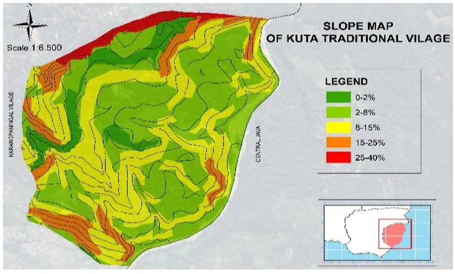
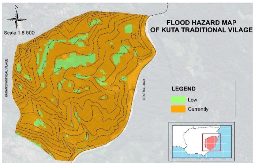
Spatial analysis of Kampung Adat Kuta identified 115 candidate spatial units distributed across five primary land-cover and customary-spatial contexts: forest buffer or Leuweung Larangan adjacency, agricultural land, transitional zone, settlement core, and riparian corridor. The input variables comprised land cover, slope gradient, hydrological condition, flood hazard exposure, and settlement morphology, collected through GIS overlay and participatory mapping. Table 7 presents the distribution of units by input category prior to model processing.
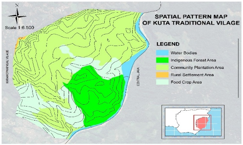
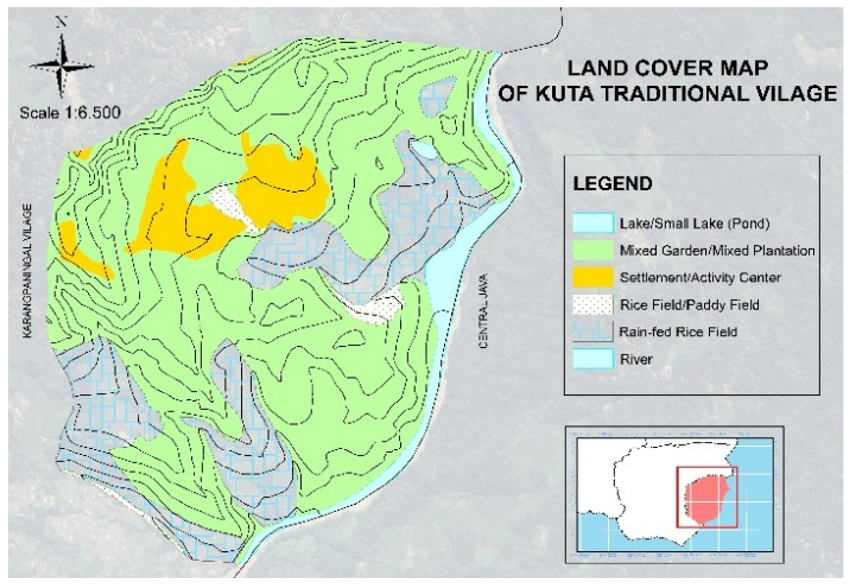
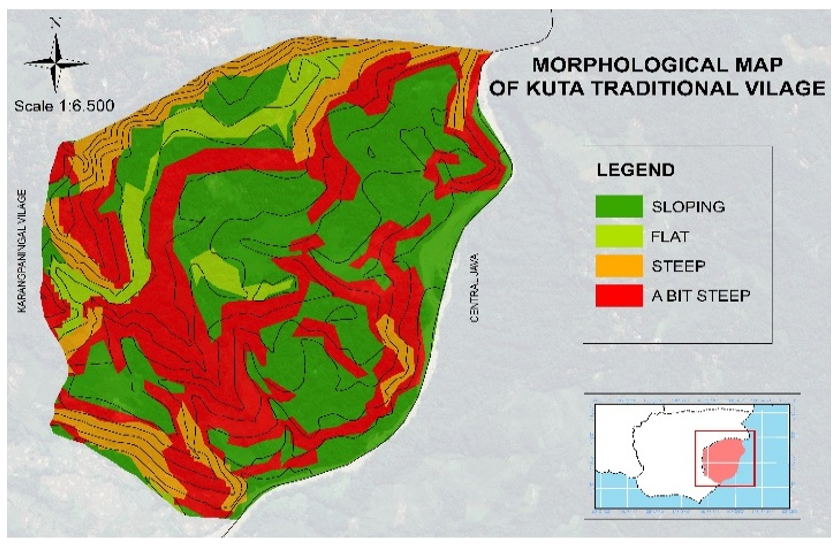
The spatial context of the 115 candidate units in Kampung Adat Kuta is illustrated in Figure 5. This visualization is derived from a synthesis of field surveys, participatory GIS sessions, and GIS overlay analysis conducted in 2024. To ensure cartographic precision, the map is projected using the WGS 84 / Universal Transverse Mercator (UTM) Zone 48S coordinate reference system. The figure integrates several critical spatial dimensions, including the delineated boundaries of the candidate units, land cover classifications, and slope gradients. Furthermore, it incorporates settlement morphology and a flood hazard index to provide a comprehensive view of the TIS input structure. Standard cartographic elements, such as a scale bar and a north arrow, are included to support spatial interpretability.
Figure 5. Spatial context of candidate spatial units in Kampung Adat Kuta
Table 7. Spatial unit distribution before model processing
|
Input Category |
n |
% |
Data Source / Model Role |
|
Settlement core |
36 |
31.3 |
PGIS and field survey / candidate unit |
|
Agricultural transition zone |
29 |
25.2 |
GIS and field survey / candidate unit |
|
Forest buffer / Leuweung Larangan adjacency |
22 |
19.1 |
PGIS and customary mapping / value-sensitive unit |
|
Riparian corridor |
28 |
24.3 |
GIS and field survey / physical and value-sensitive unit |
|
High flood exposure units |
30 |
26.1 |
GIS overlay / physical constraint |
|
Moderate slope units |
47 |
40.9 |
DEM and slope analysis / physical variable |
4.2 Value Gate results
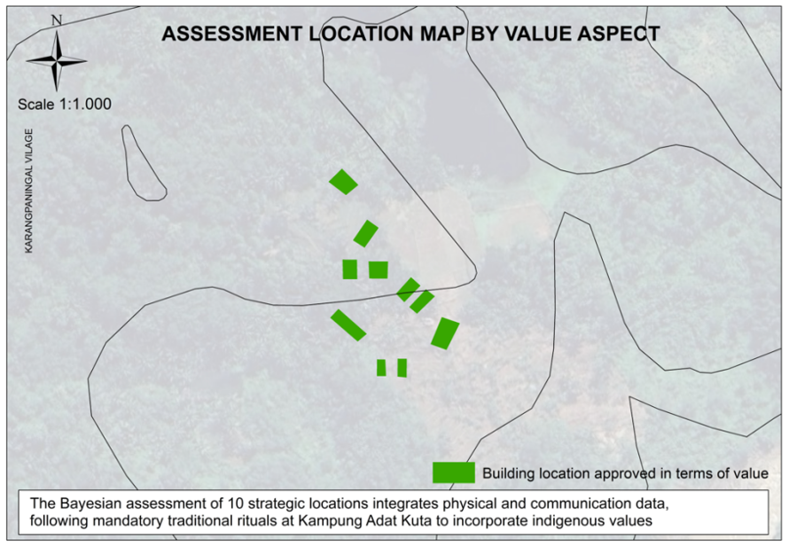
The application of the Value Gate produced a binary classification based on the cultural legitimacy of each location. As detailed in Table 8, of the 115 candidate spatial units analyzed, 85 units (73.9%) were assigned a status of V = 1, meaning they were identified as permissible, neutral, or ritually approved, allowing them to proceed to the Communication layer. Conversely, the remaining 30 units (26.1%) were assigned V = 0, indicating they were restricted, sacred, or prohibited according to customary law, and were thus automatically classified as rejected by the system. To ensure the methodological rigor of this process, the transformation of narrative customary knowledge into computational variables was subjected to independent verification, yielding an inter-coder reliability score of Cohen’s Kappa = 0.82. This score confirms a high level of consistency in the qualitative-to-computational transformation, providing a reliable foundation for the subsequent layers of the Bayesian model.
Further analysis of the units that failed the cultural screening reveals the specific reasons for rejection based on local customary law. As detailed in Table 9, the 30 restricted units consisted of 18 units overlapping with the Leuweung Larangan sacred forest boundary, 8 units subject to explicit pamali (customary prohibition) declarations from customary authorities, and the remaining 4 units located within sacred water-source or riparian customary zones. This distribution confirms that transcendental constraints in Kampung Adat Kuta possess clear spatial criteria that are documented through the participatory mapping mechanism.
Table 8. Value Gate classification results
|
Value Gate Status and Coding |
n |
% |
Decision Consequence |
|
Restricted / sacred / prohibited (V = 0) |
30 |
26.1 |
Automatically rejected |
|
Permissible / neutral / approved (V = 1) |
85 |
73.9 |
Proceeds to Communication layer |
|
Total |
115 |
100 |
- |
Table 9. Sources of Value Gate rejection
|
Restriction Type |
Number of Units |
Percentage of Restricted Units |
Validation Source |
|
Leuweung Larangan overlap |
18 |
60.0% |
Kuncen / PGIS |
|
Explicit pamali |
8 |
26.7% |
Kuncen interview / nepus |
|
Sacred water-source / riparian zone |
4 |
13.3% |
Sesepuh Adat / PGIS |
|
Total |
30 |
100% |
- |
Figure 6 presents the spatial distribution of Value Gate outcomes (V = 0 Restricted; V = 1 Permissible) across the 115 candidate units.
4.3 Communication posterior results
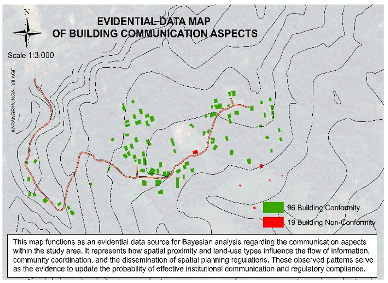
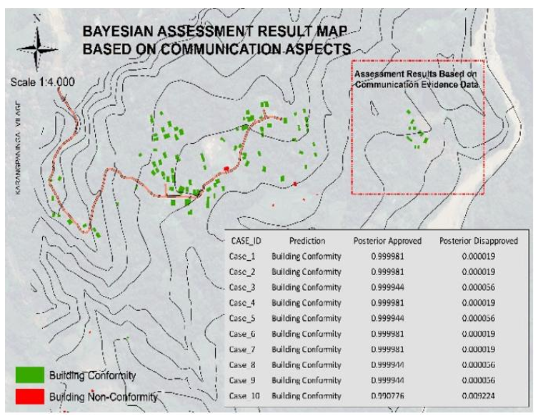
The Communication layer was subsequently applied to the 85 spatial units that successfully passed the initial screening of the deterministic Value Gate. For these units, the posterior probability of social legitimacy, denoted as P(C∣V), was computed using consensus scores recorded during FGDs with 25 key informants representing five distinct stakeholder groups.
These consensus scores, assigned on a 1–5 Likert scale, were transformed into conditional posterior probability values using frequency-based calibration derived from historical deliberation records. As detailed in Table 10, the distribution of these results demonstrates a robust social consensus within the community: 79 units (92.9%) achieved near-unanimous legitimacy with posterior values of ≥0.95, while 4 units (4.7%) recorded high legitimacy scores. Only two units (2.4%) were classified as having moderate legitimacy, which corresponded to specific locations where FGD records documented active boundary disputes and stakeholder disagreement. No units were found to have low social legitimacy (<0.60), indicating that areas deemed culturally permissible by customary authority generally align with strong community acceptance.
Table 10. Communication posterior distribution P(C|V)
|
Posterior Class and Range |
n |
% |
Interpretation |
|
Near-unanimous legitimacy (> = 0.95) |
79 |
92.9 |
Very strong consensus |
|
High legitimacy (0.80-0.94) |
4 |
4.7 |
Strong consensus |
|
Moderate legitimacy (0.60-0.79) |
2 |
2.4 |
Contested but acceptable |
|
Low legitimacy (< 0.60) |
0 |
0.0 |
Not socially legitimate |
|
Total |
85 |
100 |
- |
The two moderate-legitimacy units corresponded to locations where FGD records documented active boundary disputes and stakeholder disagreement. Figure 7 presents the spatial distribution of Communication Posterior values across the 85 eligible units.
The spatial distribution of Communication Posterior values, P(C∣V), across the 85 eligible units in Kampung Adat Kuta is illustrated in Figure 7. This visualization was derived from consensus scoring during FGDs, participatory mapping, and Bayesian posterior computations conducted in 2024. For cartographic accuracy, the map is projected using the WGS 84 / UTM Zone 48S coordinate reference system. The legend classifies social legitimacy into three distinct tiers: dark blue represents near-unanimous consensus (≥0.95), medium blue indicates high legitimacy (0.80–0.94), and light blue denotes moderate legitimacy (0.60–0.79). Standard map elements, including a scale bar and a north arrow, are incorporated to ensure spatial interpretability.
(a)
(b)
Figure 7. Communication layer
4.4 Physical feasibility posterior results
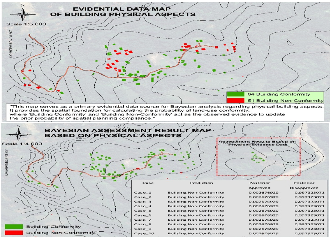
Physical feasibility assessment was conducted for the 85 units that successfully cleared the deterministic Value Gate by computing the conditional posterior probability, denoted as P(P∣C,V). This assessment utilized a GIS-based overlay analysis encompassing four critical environmental parameters: slope gradient, land-cover type, hydrological conditions, and flood hazard exposure. Each parameter was systematically classified into suitability tiers and converted to conditional posterior values through a GIS suitability lookup table calibrated against direct field observations.
As detailed in Table 11, the resulting distribution reveals that 54 units (63.5%) achieved high physical feasibility (≥0.75), while 30 units (35.3%) were classified as having moderate feasibility (0.60–0.74). Notably, only one unit (1.2%) demonstrated very low feasibility, yielding the lowest observed posterior value of 0.0027. This extreme constraint case occurred in a target location where the slope gradient exceeded 25% and flood hazard exposure was categorized as class IV, representing the upper limits of environmental risk in the study area. The spatial distribution of these Physical Posterior values across the 85 eligible units is illustrated in Figure 8.
Table 11. Physical feasibility posterior distribution P (P|C, V)
|
Physical Posterior Class and Range |
n |
% |
Interpretation |
|
High feasibility (> = 0.75) |
54 |
63.5 |
Physically feasible |
|
Moderate feasibility (0.60-0.74) |
30 |
35.3 |
Feasible with caution |
|
Low feasibility (0.40-0.59) |
0 |
0.0 |
Marginal / constrained |
|
Very low feasibility (< 0.40) |
1 |
1.2 |
Not physically feasible |
|
Lowest observed case (0.0027) |
1 |
- |
Extreme constraint case |
Figure 8 presents the spatial distribution of Physical Posterior values P (P|C, V) across the 85 eligible units.
4.5 Integrated model output and key summary table
The integrated model output provides a comprehensive summary of how the three-layer decision sequence translates value, communication, and physical variables into final predicted outcomes. As synthesized in Table 12, the results demonstrate a hierarchical logic where the deterministic Value Gate first eliminates culturally restricted units, while the Communication and Physical layers refine the classification for those units that pass the initial cultural screening.
Table 12. Key summary of Transcendental Integrative System (TIS) model outputs (n = 115)
|
Model Component and Classification |
n |
% |
Decision Implication |
|
Value Gate: V = 0 / restricted |
30 |
26.1 |
Automatically rejected |
|
Value Gate: V = 1 / permissible |
85 |
73.9 |
Proceeds to C layer |
|
Communication: >= 0.95 |
79 |
68.7 total; 92.9 eligible |
Strong social legitimacy |
|
Communication: 0.80-0.94 |
4 |
3.5 total; 4.7 eligible |
High legitimacy |
|
Communication: 0.60-0.79 |
2 |
1.7 total; 2.4 eligible |
Moderate legitimacy |
|
Physical: >= 0.60 |
84 |
73.0 total; 98.8 eligible |
Physically feasible |
|
Physical: < 0.60 |
1 |
0.9 total; 1.2 eligible |
Physically constrained |
|
Final prediction: accepted |
84 |
73.0 |
Model accepted |
|
Final prediction: rejected |
31 |
27.0 |
Model rejected |
|
Observed decision: accepted |
85 |
73.9 |
Field accepted |
|
Observed decision: rejected |
30 |
26.1 |
Field rejected |
For ten representative target spatial units, the model operationalized the probability chain P(D)=P(V)×P(C∣V)×P(P∣C,V) to produce traceable accept/reject decisions at the individual unit level.
A critical finding of this integration is the non-compensatory nature of the system: cases with very low physical posterior values—including the lowest observed value of 0.0027—were classified as rejected by the system even when they had cleared the Value Gate and recorded high Communication Posterior scores. In total, 84 of the 85 units that passed the Value Gate were predicted as accepted, which is consistent with the finding that only one unit recorded a physical posterior below the required feasibility threshold. It is important to note that while physical posterior classes are calculated only for the 85 units eligible after cultural screening, the final prediction classes represent the complete model output across all 115 spatial units after integrating all three layers. As detailed in the Confusion Matrix in Table 13, the single unit failing the physical threshold was classified as rejected alongside the 30 units failing the Value Gate, producing a total of 31 predicted-rejected units. This structured output ensures that spatial recommendations remain grounded in both indigenous legitimacy and environmental safety.
Table 13. Confusion matrix of the Transcendental Integrative System (TIS) Bayesian Hierarchical Gating model (n = 115)
|
|
Observed Accepted |
Observed Rejected |
Total Predicted |
|
Predicted Accepted |
73 TP |
11 FP |
84 |
|
Predicted Rejected |
12 FN |
19 TN |
31 |
|
Total Observed |
85 |
30 |
115 |
4.6 Prediction accuracy and baseline comparison
Overall model performance was evaluated by comparing model-predicted decisions with observed spatial decision outcomes across 115 spatial units. The TIS model achieved an accuracy of 0.80, correctly classifying 73 units as accepted (TP) and 19 units as rejected (TN) out of 115. This result outperforms both the standard Naïve Bayes benchmark (accuracy 0.74) and the physical-suitability-only baseline (accuracy 0.62), indicating that the hierarchical gating structure improves classification performance compared with models that either assume conditional independence or rely only on physical suitability.
4.7 Community validation results
Community validation confirmed the cultural and social credibility of the model outputs, ensuring that the algorithmic results remained aligned with indigenous spatial logic. The validation process involved a multi-stakeholder group, including the Kuncen (ritual custodian), Sesepuh Adat (elders), village officials, community figures, and representative residents. As detailed in Table 14, the protocol combined participatory map checking, FGD reviews, and the Nepus ritual verification to confirm spatial boundaries, Value Gate status, and social legitimacy scores.
A critical component of this protocol was the formal procedure for handling discrepancies. In instances where model predictions conflicted with customary authority, the customary decision was treated as the final cultural constraint, and the Value Gate was recalibrated accordingly to preserve the system's role as a decision-support tool rather than an autonomous decision-maker.
The robustness of the model, following this rigorous community verification, is synthesized in Table 15. The results show that the TIS Bayesian Hierarchical Gating Model achieved an accuracy of 0.80 and an F1-score of 0.86, significantly outperforming both the standard Naïve Bayes benchmark (accuracy 0.74) and the physical-suitability-only baseline (accuracy 0.62). This performance demonstrates that integrating transcendental values as a deterministic gate produces spatial classifications that are both statistically accurate and culturally legitimate.
Table 14. Community validation outputs
|
Validation Stage |
Participants |
Method / Documentation |
Output |
|
Map-based verification |
Village officials, figures, residents |
PGIS checking; FGD; attendance and map notes |
Refined spatial boundaries |
|
Value Gate validation |
Kuncen and Sesepuh Adat |
Nepus and customary statement |
Final restricted/permissible status |
|
Conflict handling |
Customary leaders and research team |
Compare model and customary decision; discrepancy log |
Recalibrated Value Gate |
|
Final confirmation |
Community representatives |
Joint review and validation record |
Validated observed dataset |
Table 15. Model performance comparison
|
Model Configuration |
Accuracy |
Precision |
Recall |
|
TIS Bayesian Hierarchical Gating Model |
0.80 |
0.87 |
0.86 |
|
Standard Naïve Bayes benchmark |
0.74 |
0.78 |
0.82 |
|
Physical-suitability-only baseline |
0.62 |
0.65 |
0.68 |
5.1 Cultural legitimacy as a non-compensatory constraint
The results as a whole demonstrate that the principal contribution of TIS is not simply higher classification accuracy, but the formalisation of culturally embedded decision authority into an auditable computational sequence in which each rejection is traceable to a specific cultural, social, or physical constraint. The Value Gate results demonstrate that cultural legitimacy operates as a non-compensatory planning constraint rather than as an additional preference in a weighted suitability model. The rejection of 30 spatial units through customary rules confirms that sacred boundaries, pamali, and ritual validation function as binding decision thresholds, consistent with indigenous planning and sacred ecology scholarship [4, 5, 21]. This finding strengthens the central novelty of TIS: cultural legitimacy is encoded as a gate that determines whether a spatial unit may enter further analysis.
The nine units that would have been considered physically suitable under conventional analysis but were rejected by the Value Gate show the limitation of technocratic suitability models. Unlike multi-criteria decision analysis (MCDA)-based approaches that allow trade-offs among variables, the TIS architecture prevents culturally restricted space from being compensated by high physical scores [17, 28, 29]. This non-compensatory structure is the main distinction between TIS and conventional spatial suitability modelling.
5.2 Probabilistic representation of social legitimacy
The Communication Posterior results indicate that social legitimacy is strongly shaped by prior cultural permissibility. The high proportion of units with P(C|V) >= 0.95 should therefore be interpreted as evidence that customary legitimacy structures the range of socially acceptable options, rather than as a simple statistical artifact [12, 14, 30]. This supports the argument that participation becomes meaningful only when embedded within recognized institutional and cultural authority, a concept central to reaching meaningful public participation in spatial planning [16]. This is further reinforced by recent research suggesting that integrating multi-stakeholder perspectives is essential for quantifying cultural indicators and identifying the trade-offs required for culturally grounded landscape management [31].
By translating consensus and disagreement into posterior probabilities, TIS preserves social uncertainty rather than erasing it. This is important for explainable and accountable planning systems because contested units can be traced to specific boundary disputes, stakeholder disagreement, or institutional ambiguity [20, 32]. The Communication layer therefore extends communicative planning by turning deliberative legitimacy into an auditable computational output.
5.3 Conditional physical feasibility and limits of technocratic suitability models
The variation in Physical Posterior values across eligible units demonstrates that environmental feasibility remains decisive but conditional. The lowest posterior values were observed in environmentally constrained target cases, particularly where slope, hydrological exposure, and flood risk coincided, confirming that physical data must be interpreted within culturally and socially validated decision sequences [6, 7, 17].
This finding sharpens the critique of physical-suitability-only models. Environmental optimisation is necessary for sustainable planning, but it is insufficient when spatial decisions are also governed by ritual authority, social legitimacy, and customary restrictions [1, 19]. The TIS model therefore integrates environmental feasibility without allowing technocratic optimisation to override cultural and social constraints.
5.4 Bayesian Hierarchical Gating as a planning architecture
The Bayesian Hierarchical Gating Model advances spatial decision-support methodology by replacing independent-variable classification with a sequential decision architecture. Standard Naïve Bayes is useful as a benchmark because of its computational simplicity, but its conditional-independence assumption cannot represent the relational dependency between customary legitimacy, consensus, and physical feasibility in traditional settlements [7, 18, 19].
The model performance comparison supports this architectural choice. The TIS model achieved higher accuracy than both the Naïve Bayes benchmark and the physical-only baseline, indicating that the deterministic Value Gate, the Communication Posterior, and the conditional Physical layer jointly improve classification performance [17, 20]. This performance gain is not merely statistical; it demonstrates that the model structure better reflects the actual hierarchy of decision authority in Kampung Adat Kuta.
The model also contributes to explainable spatial AI because each decision can be traced through the sequence V -> C -> P. Unlike black-box prediction, the TIS output can be audited by identifying whether a unit is rejected because of cultural restriction, social disagreement, or physical constraint [20, 32, 33].
Figure 9 synthesizes the TIS as a layered spatial computational architecture in which cultural, communicative, and environmental knowledge flows through the sequential decision chain V→C→P. The diagram shows the deterministic Value Gate, the Bayesian Communication Posterior, and the conditional Physical Feasibility layer, with the probability chain P(D) = P(V) × P(C|V) × P(P|C,V) annotated at each transition. All labels and legend elements are reproduced at 300 dpi for print clarity.

Figure 9. Transcendental Integrative System architecture
5.5 Theoretical contributions to planning theory
The study contributes to planning theory by operationalizing three planning paradigms within a single computational architecture. Rational-comprehensive planning is represented through the Physical layer, communicative planning through the Communication Posterior, and phenomenological planning through the Value Gate [11-13]. The contribution is not an additive combination of paradigms, but a hierarchical translation of different planning rationalities into different computational functions.
The core novelty is therefore that cultural values are not merely included in the model; they are assigned a distinct computational role. Transcendental value becomes a deterministic rule, social legitimacy becomes a posterior probability, and physical feasibility becomes a conditional environmental probability [17, 20, 22]. This shows that phenomenological and communicative insights can be operationalised without reducing them to arbitrary numerical weights.
5.6 Policy and planning implications
For planning policy and practice, TIS offers a decision-support framework for traditional settlement planning, heritage-sensitive zoning, village spatial planning, and customary land governance [34, 35]. Its main policy value lies in making the basis of each spatial decision explicit: planners can see whether a unit is rejected because of customary restriction, social disagreement, or physical constraint, while communities can use validation forums to review and recalibrate model outputs [16, 17, 20, 36].
The model should be understood as transferable after local recalibration rather than universally generalisable. Each settlement possesses distinct customary authorities, sacred geographies, social deliberation structures, heritage morphologies, and environmental risks; therefore, TIS should be understood as a replicable protocol and process innovation framework rather than as a universal formula [4, 27, 37, 38]. This position preserves the sovereignty of local knowledge while allowing formal planning institutions to engage with it systematically.
5.7 Limitations and future research
Several limitations bound the scope of the study. The model is calibrated and validated within a single case study, the 115 spatial units reflect the spatial and governance structure of Kampung Adat Kuta, and the probability thresholds remain context-specific. Application in other settlements requires recalibration of priors, thresholds, and Value Gate rules through local participatory validation [6, 19, 28].
Future research should test the TIS architecture across multiple traditional settlements with different governance structures, develop dynamic Bayesian updating for temporal change, and examine integration with formal Indonesian spatial planning instruments at district and provincial levels. Additional work should explore how explainable AI interfaces can help communities inspect and contest model outputs without surrendering decision authority to algorithmic systems [17, 22].
This study developed and validated a Bayesian Hierarchical Gating Model as the computational core of the TIS for culturally grounded spatial decision-making in traditional settlements. Applied to 115 candidate spatial units in Kampung Adat Kuta, the model achieved an accuracy of 0.80 and an F1-score of 0.86, outperforming both the physical-suitability-only baseline and the standard Naïve Bayes benchmark.
The findings confirm that spatial decisions in culturally embedded settlements are governed by a non-compensatory hierarchy. The Value Gate eliminates culturally restricted units before social or physical evaluation, the Communication layer translates legitimacy into posterior probability, and the Physical layer evaluates environmental feasibility conditionally. This sequence provides an auditable structure for integrating customary authority, social consensus, and environmental evidence.
The main contribution of the study is methodological and theoretical. It demonstrates that transcendental and phenomenological planning concepts can be operationalised as computational decision rules without reducing them to compensatory weights. The TIS framework offers a replicable decision-support protocol for heritage-sensitive zoning, village spatial planning, and customary land governance, while remaining subordinate to community validation and local authority.
The model remains context-specific and requires recalibration before transfer to other settlements. Future research should test the architecture across multiple traditional settlement contexts, incorporate temporal Bayesian updating, and develop participatory interfaces that allow communities and planners to audit model outputs collaboratively.
The authors would like to express their sincere gratitude to the Institute for Research and Community Service (LPPM) of Universitas Islam Bandung for their support and facilitation throughout this research. This study was funded by the Ministry of Education, Culture, Research, and Technology of the Republic of Indonesia (Kemdikbudristek) under the Research Grant Program for Fiscal Year 2024, based on Contract No. 305/B.04/Rek/VI/2024. The authors also extend their appreciation to all parties who have contributed, both directly and indirectly, to the successful completion of this research.
[1] Leach, M., Scoones, I., Stirling, A.C. (2010). Dynamic Sustainabilities: Technology, Environment, Social Justice. Routledge, London, pp. 232. https://doi.org/10.4324/9781849775069
[2] Meerow, S., Newell, J.P., Stults, M. (2016). Defining urban resilience: A review. Landscape and Urban Planning, 147: 38-49. https://doi.org/10.1016/j.landurbplan.2015.11.011
[3] Scoones, I. (2016). The politics of sustainability and development. Annual Review of Environment and Resources, 41: 293-319. https://doi.org/10.1146/annurev-environ-110615-090039
[4] Sandercock, L. (2004). Interface: Planning and indigenous communities. Planning Theory & Practice, 5(1): 95-97. https://doi.org/10.1080/1464935042000204213
[5] Berkes, F. (2017). Sacred Ecology. Routledge, New York, pp.394. https://doi.org/10.4324/9781315114644
[6] Seker, D., Orak, N.H. (2025). Adaptive decision-making: Bayesian Network Modeling for blue-green infrastructure selection in dynamic climate and land use context. Environmental Data Science, 3: e37. https://doi.org/10.1017/eds.2024.55
[7] Krapu, C., Stewart, R., Rose, A. (2023). A review of Bayesian networks for spatial data. ACM Transactions on Spatial Algorithms and Systems, 9(1): 7. https://doi.org/10.1145/3516523
[8] Richter, K.F., Scheider, S. (2023). Current topics and challenges in geoAI. Kuenstliche Intelligenz, 37(1): 11-16. https://doi.org/10.1007/s13218-022-00796-0
[9] Floridi, L., Cowls, J., Beltrametti, M., Chatila, R., et al. (2018). AI4People-An ethical framework for a good AI society: Opportunities, risks, principles, and recommendations. Minds and Machines, 28(4): 689-707. https://doi.org/10.1007/s11023-018-9482-5
[10] Mittelstadt, B.D., Allo, P., Taddeo, M., Wachter, S., Floridi, L. (2016). The ethics of algorithms: Mapping the debate. Big Data & Society, 3(2): 21. https://doi.org/10.1177/2053951716679679
[11] Allmendinger, P. (2017). Planning theory. London, Bloomsbury Publishing, pp.1-331. https://books.google.com.sg/books?hl=zh-CN&lr=&id=rJNKEAAAQBAJ&oi=fnd&pg=PR1&dq=Planning+Theory,+2nd+ed.+Palgrave+Macmillan,+Basingstoke&ots=2HY6dHwOwV&sig=sIuhSt_lFNcW-eoaKTA9YzPLkq0&redir_esc=y#v=onepage&q&f=false.
[12] Healey, P. (2020). Collaborative Planning: Shaping Places in Fragmented Societies. London, Bloomsbury Publishing, pp. 3-363.
[13] Norberg-Schulz, C. (1979). Genius Loci: Towards a Phenomenology of Architecture. Rizzoli, New York.
[14] Innes, J.E. (1995). Planning theory's emerging paradigm: Communicative action and interactive practice. Journal of Planning Education and Research, 14(3): 183-189. https://doi.org/10.1177/0739456X9501400307
[15] Innes, J.E., Booher, D.E. (2010). Planning with Complexity: An Introduction to Collaborative Rationality for Public Policy. Routledge, London. https://doi.org/10.4324/9780203864302
[16] Bakowska-Waldmann, E., Kaczmarek, T. (2021). The use of PPGIS: Towards reaching a meaningful public participation in spatial planning. ISPRS International Journal of Geo-Information, 10(9): 581. https://doi.org/10.3390/ijgi10090581
[17] Steward, R., Chopin, P., Verburg, P.H. (2024). Supporting spatial planning with a novel method based on participatory Bayesian networks: An application in Curacao. Environmental Science & Policy, 156: 103733. https://doi.org/10.1016/j.envsci.2024.103733
[18] Zhang, H. (2004). The optimality of Naïve Bayes. Aa, 1(2): 3.
[19] Domingos, P., Pazzani, M. (1997). On the optimality of the simple Bayesian classifier under zero-one loss. Machine Learning, 29: 103-130. https://doi.org/10.1023/A:1007413511361
[20] Coussement, K., Abedin, M.Z., Kraus, M., Maldonado, S., Topuz, K. (2024). Explainable AI for enhanced decision-making. Decision Support Systems, 184: 114276. https://doi.org/10.1016/j.dss.2024.114276
[21] Saptenno, M.J., Timisela, N.R. (2024). Assessing the role of local Sasi practices in environmental conservation and community economic empowerment in Maluku, Indonesia. International Journal of Sustainable Development and Planning, 19(4): 1407-1413. https://doi.org/10.18280/ijsdp.190418
[22] Seamon, D. (2018). Life Takes Place: Phenomenology, Lifeworlds, and Place Making. London, Routledge, pp. 256. https://doi.org/10.4324/9781351212519
[23] Pearl, J. (2014). Probabilistic Reasoning in Intelligent Systems: Networks of Plausible Inference. Elsevier.
[24] Kang, Y.H. (2025). Human-centered geospatial data science. arXiv. https://doi.org/10.48550/arXiv.2501.05595
[25] Creswell, J. W., Creswell, J. D. (2017). Research Design: Qualitative, Quantitative, And Mixed Methods Approaches. Thousand Oaks, California, Sage publications.
[26] Suwarlan, S.A., Lai, L.Y., Said, I. (2023). Social norms framework of Suku Laut in traditional coastal settlement of Mainland Batam. International Journal of Sustainable Development and Planning, 18(3): 703-713. https://doi.org/10.18280/ijsdp.180306
[27] Swain, S., Jena, D., Panda, I., Das, P.K. (2025). Effect of Forest Rights Acts 2006 on the livelihoods of tribals: An empirical study of the Juang Tribe in Keonjhar District, Odisha. International Journal of Sustainable Development and Planning, 20(7): 3067-3072. https://doi.org/10.18280/ijsdp.200731
[28] Malczewski, J. (2006). GIS‐based multicriteria decision analysis: A survey of the literature. International Journal of Geographical Information Science, 20(7): 703-726. https://doi.org/10.1080/13658810600661508
[29] Chen, Y., Yu, J., Khan, S. (2010). Spatial sensitivity analysis of multi-criteria weights in GIS-based land suitability evaluation. Environmental Modelling & Software, 25(12): 1582-1591. https://doi.org/10.1016/j.envsoft.2010.06.001
[30] Rahmawati, Prayitno, G., Firdausiyah, N., Dinanti, D., Adrianto, D.W. (2024). Social capital and quality of life in an Indonesian rural tourism village. International Journal of Sustainable Development and Planning, 19(4): 1361-1370. https://doi.org/10.18280/ijsdp.190413
[31] Li, J.X., Li, K.K., Wang, Y.B., Jiao, R. (2024). Comparative study on the perception of cultural ecosystem services in Taibai Mountain National Forest Park from different stakeholder perspectives. Land, 13(12): 2207. https://doi.org/10.3390/land13122207
[32] Dwivedi, R., Dave, D., Naik, H., Singhal, S., et al. (2023). Explainable AI (XAI): Core ideas, techniques, and solutions. ACM Computing Surveys, 55(9): 194. https://doi.org/10.1145/3561048
[33] Saarela, M., Podgorelec, V. (2024). Recent applications of explainable AI (XAI): A systematic literature review. Applied Sciences, 14(19): 8884. https://doi.org/10.3390/app14198884
[34] Koumetio Tekouabou, S.C., Diop, E.B., Azmi, R., Jaligot, R., Chenal, J. (2022). Reviewing the application of machine learning methods to model urban form indicators in planning decision support systems: Potential, issues and challenges. Journal of King Saud University - Computer and Information Sciences, 34(8): 5943-5967. https://doi.org/10.1016/j.jksuci.2021.08.007
[35] Fadhel, M.A., Duhaim, A.M., Saihood, A., Sewify, A., Al-Hamadani, M.N.A., Albahri, A.S., Alzubaidi, L., Gupta, A., Mirjalili, S., Gu, Y. (2024). Comprehensive systematic review of information fusion methods in smart cities and urban environments. Information Fusion, 107: 102317. https://doi.org/10.1016/j.inffus.2024.102317
[36] Hermawan, A., Guntoro, B., Sulhan, M. (2024). Community engagement for disaster preparedness in rural areas of Mount Merapi, Indonesia. International Journal of Sustainable Development and Planning, 19(4): 1505-1518. https://doi.org/10.18280/ijsdp.190427
[37] Liu, P., Biljecki, F. (2022). A review of spatially-explicit GeoAI applications in urban geography. International Journal of Applied Earth Observation and Geoinformation, 112: 102936. https://doi.org/10.1016/j.jag.2022.102936
[38] Raju, S.S., Leong, W.Y. (2025). AI-driven automation in software testing: Enabling SME adoption. INTI Journal, 2025(1): 1-6.