Jamilah Abbas![]() | Sumbangan Baja*
| Sumbangan Baja*![]() | Risma Neswati
| Risma Neswati![]()
© 2026 The authors. This article is published by IIETA and is licensed under the CC BY 4.0 license (http://creativecommons.org/licenses/by/4.0/).
OPEN ACCESS
Land use conflicts in ecotourism areas often arise due to the intersection of conservation, tourism development, and local livelihoods, due to land use dynamics. The Malino Nature Tourism Park (TWA Malino) in Gowa Regency, South Sulawesi, serves as a critical conservation zone while simultaneously being developed as a tourism destination. This dual function presents challenges in harmonizing land use practices with ecological sustainability and spatial planning policies. The objective of this study is to analyse land use dynamics and their sustainability with the spatial planning pattern and to formulate spatial planning strategies to mitigate land use conflicts. This research utilized a mixed-methods approach, integrating spatial analysis with qualitative stakeholder assessments. Spatial data, including land use and administrative zoning maps, were analyzed using GIS overlay techniques to identify mismatches between actual land use and spatial plans. Key informant interviews, direct field observations, and document reviews were conducted to identify conflict patterns and stakeholder perspectives. The findings were synthesized to develop strategic spatial planning recommendations. The results show significant discrepancies between actual land use and Provincial Spatial Plan (RTRW) zoning. Approximately 19% of the TWA Malino area experienced mismatched land use, including settlements, agricultural conversion, and tourism facilities encroaching on conservation zones. Spatial conflicts are rooted in overlapping institutional mandates, weak enforcement of zoning regulations, and diverging stakeholder interests. Three primary types of conflict were identified: institutional (e.g., overlapping authority between conservation and tourism agencies), operational (e.g., unregulated infrastructure development), and normative (e.g., differences in values between local communities and government planners). Strengths, Weaknesses, Opportunities, Threats (SWOT) analysis positioned TWA Malino in Quadrant II (High Opportunity, Moderate Internal Capacity) of the IE Matrix, suggesting a growth strategy with a focus on environmental sustainability and governance enhancement. These findings underscore the urgent need for integrative spatial planning that balances ecological protection with tourism development. The study recommends strengthening zoning enforcement, improving inter-agency coordination, and enhancing community-based ecotourism initiatives. Moreover, participatory governance and transparent benefit-sharing mechanisms are essential to mitigate conflict and foster long-term sustainability. By leveraging TWA Malino’s ecological potential and addressing current planning deficiencies, the area can evolve into a model for green and inclusive tourism development in Indonesia.
land use conflict, spatial planning, Ecotourism, GIS, Malino Nature Tourism Park
The rapid growth of tourism, particularly nature-based tourism, within protected areas has significantly contributed to widespread land use conversion [1]. Forested lands, conservation zones, and other ecologically sensitive regions are increasingly being transformed into built-up areas such as resorts, homestays, and tourism infrastructure [2, 3]. This phenomenon reflects a broader trend observed globally and nationally, where human demand for land outpaces the availability of land itself, leading to spatial mismatches between land use and land suitability [4, 5]. In Malino, a strategic tourism area in South Sulawesi, such land conversions manifest in the transformation of agricultural or forest lands into accommodation zones and commercial uses, in response to growing tourist demand. Land, as a surface component encompassing the biosphere, atmosphere, soil, geology, hydrology, vegetation, and anthropogenic influences [6, 7], is inherently sensitive to such rapid and often unplanned transformations. As tourism expands, it places mounting pressure on local ecosystems, reducing vegetation cover, fragmenting wildlife habitats, and increasing the risk of erosion, particularly in steep terrains.
Land use change, defined as the alteration in the ways humans utilize land, often results from urban expansion, infrastructure development, and economic pursuits such as tourism. While it may offer socio-economic benefits, it also brings about negative environmental consequences when not managed appropriately. In both urban and rural areas, productive green spaces are shrinking due to the sprawl of housing, industrial, and service sectors [8-10]. This pattern is particularly visible in ecotourism zones where the economic allure of tourism often overshadows conservation imperatives. Left unchecked, these changes can degrade the economic value of land and reduce its ecological functionality [11]. Moreover, land use change has led to significant biodiversity loss and degradation of ecosystem services globally due to intensive land use such as commercial agriculture, forest clearance, and uncontrolled urbanization [6, 12-14]. The shift from natural vegetation to built environments has become a critical environmental concern, particularly in areas like Malino that are ecologically sensitive yet economically driven by tourism.
Balancing conservation objectives with regional economic development remains a central challenge in managing land use within protected areas. In the case of Malino, a Strategic Provincial Area (KSP) as designated by the South Sulawesi Regional Regulation No. 3 of 2022 concerning the Provincial Spatial Plan (RTRW) for 2022–2041, the region is experiencing significant spatial transformation driven by population growth, rising land demand, and shifting lifestyles [10, 15]. These pressures have led to land conversion trends that compromise ecological integrity, including forest clearance for tourism infrastructure and settlements. While spatial planning is prioritized for Malino due to its ecological function and environmental carrying capacity, conflicts emerge when development exceeds these limits. The ecological consequences of land conversion include habitat fragmentation, biodiversity loss, and altered hydrological functions, which in turn affect long-term ecological sustainability [6]. Social consequences also arise, such as disputes over land tenure, exclusion of local communities from planning processes, and uneven distribution of tourism benefits.
Tourism, on the other hand, is a vital economic driver for the region. The development of tourism infrastructure—particularly hotels and accommodations—has become the primary source of locally generated revenue in Malino, with natural attractions serving as support elements to this economic activity [16]. From a socio-economic perspective, tourism expansion offers numerous benefits, such as increased household income, employment generation, local entrepreneurship development, and regional economic growth. However, as tourism flourishes, it often leads to the intensification of land use and accelerates land conversion processes, further straining already limited land resources [6, 7]. The dilemma lies in ensuring that tourism development aligns with spatial and environmental plans to avoid irreversible degradation. In this regard, Malino exemplifies the broader challenge of aligning environmental sustainability with economic aspirations in ecologically sensitive tourism areas.
One of the major challenges in the Malino Protected Area is the recurring spatial conflict arising from inconsistencies between the designated spatial plans—both at the provincial level, as regulated by South Sulawesi Provincial Regulation No. 3 of 2022, and the district-level spatial planning—and the actual land use on the ground. The planned zoning for conservation, agroforestry, and buffer zones is frequently violated by the establishment of tourism infrastructure, settlements, and agricultural expansion. These discrepancies highlight the spatial mismatch between regulation and practice, which has been further intensified by the rapid socio-economic development of the region and increasing land demands [10]. The overlapping land use interests between conservation, tourism, farming, and residential development create significant spatial tension, particularly where protected zones are converted into built-up or horticultural areas without regard to land suitability or environmental thresholds. Such conditions threaten ecological stability and reduce the effectiveness of long-term spatial planning.
The issue is further compounded by the fragmented governance structure and overlapping institutional authorities that manage the area. The Ministry of Environment and Forestry is tasked with managing conservation zones, while local governments prioritize regional tourism development and economic revenue generation [17]. Disputes between central and regional governments regarding control over land allocation and development priorities have led to weak inter-agency coordination and inconsistent implementation of zoning regulations. Tensions also emerge between local communities and external investors, as land traditionally used for subsistence agriculture or cultural activities is increasingly appropriated for commercial tourism ventures. The weakness of current spatial policies lies in their limited incorporation of ecological carrying capacity as a baseline for development [6, 7], resulting in spatial plans that are insufficiently adaptive to environmental constraints. Consequently, spatial conflicts in Malino persist due to inadequate regulatory enforcement, siloed institutional agendas, and a lack of integrated ecological planning.
The spatial conflicts observed in the Malino Protected Area, if left unaddressed, will pose serious long-term consequences, including the degradation of conservation zones, reduced quality of ecosystem services, and the escalation of social tensions among stakeholders competing for limited land resources. As development pressures continue to mount, especially from tourism and agricultural sectors, the ecological integrity of the region is increasingly at risk. These challenges highlight the urgent need for a strategic planning approach that is not only spatially grounded but also ecologically and socially responsive. In this context, the integration of Strengths, Weaknesses, Opportunities, Threats (SWOT) analysis into spatial planning provides a practical and systematic framework to assess internal strengths and weaknesses of land use policies, while identifying external opportunities and threats to conservation efforts and tourism development. This research offers a novel contribution by combining spatial-temporal analysis of land use changes with strategic planning tools, specifically tailored to protected tourism landscapes. The adaptive spatial strategies proposed are designed to reflect local ecological characteristics, accommodate stakeholder interests, and strengthen institutional coordination. By aligning ecological thresholds with development goals, this study advances a more integrated and sustainable model of spatial governance in areas facing complex land use conflicts.
This study aims to investigate the spatial dynamics and land use conflicts occurring within the Malino Protected Area, with a particular focus on balancing conservation efforts and tourism development. The following specific objectives are formulated to analyze the discrepancies between actual land use and the official spatial planning regulations at both provincial and district levels, to identify the various forms of Land use conflicts occurring in the Malino Ecotourism Area, and to formulate SWOT-based spatial planning strategies aimed at mitigating land use conflicts and achieving a balance between conservation and tourism development.
2.1 Study area
The study is conducted in the Malino Ecotourism Area, designated as a KSP due to its significant ecological function and environmental carrying capacity, with a delineation area of 12,166.12 ha. The Malino Ecotourism Area lies at an elevation of 1,050–1,700 meters above sea level with hilly to mountainous topography dominated by slopes above 25%, making it vulnerable to erosion and landslides. The region records an average annual rainfall of 2,200–2,800 mm, with peak intensity between November and April, creating high surface runoff. The area is covered by montane forest vegetation, mixed plantations of coffee and clove, and horticultural crops such as vegetables and flowers that support local livelihoods. Hydrologically, Malino is a critical watershed, supplying springs and tributaries of the Jeneberang River that provide water for agriculture, settlements, and downstream urban areas (see Figure 1).

Figure 1. Study area location
2.2 Spatial zoning and present land use categories
The research specifically examines land use changes occurring over the period 2015–2024 and analyzes their conformity with spatial planning as defined by South Sulawesi Provincial Regulation No. 3 of 2022 (RTRW 2022–2041), as well as the Regency Spatial Plan outlined in Gowa District Regulation No. 15 of 2012.
Based on the Regulation of the Ministry of Agrarian Affairs and Spatial Planning/National Land Agency of the Republic of Indonesia Number 14 of 2021, spatial planning zoning is classified into the following categories (see Table 1).
Table 1. Spatial planning zoning categories
|
No. |
Spatial Zoning Category |
Description |
|
1 |
Conservation Forest |
A land and/or marine area with distinct ecological characteristics, preserved and utilized sustainably as a single ecosystem unit. |
|
2 |
Limited Production Forest |
Forest area characterized by slope class, soil type, and rainfall intensity, with a weighted index ranging from 125 to 174, outside of protected forests and nature reserves. |
|
3 |
Protected Forest |
Forest area functions primarily to protect life-supporting systems, including water regulation, flood control, erosion prevention, seawater intrusion reduction, and soil fertility maintenance. |
|
4 |
Agroforestry |
Optimization of forest land through mixed planting (trees and non-tree crops and/or animals) under community forest management licenses, aimed at improving productivity without altering primary forest functions. |
|
5 |
Plantation: |
Areas with potential for development and use, either in wet or dry zones, for estate crops. |
|
6 |
Wetland Agriculture |
Irrigated wetlands, tidal swamps, floodplains, and non-irrigated lowlands are used or potentially developed for food crops. |
|
7 |
Horticulture |
Dryland areas suitable for monoculture or intercropping of horticultural crops. |
|
8 |
Water Body |
Natural surface water features such as rivers, lakes, ponds, and reservoirs. |
|
9 |
Residential |
Urban or rural settlement zones outside of protected areas, designated for housing and livelihood-supporting activities. |
Based on the Indonesian National Standard issued by the National Standardization Agency of the Republic of Indonesia regarding Land Use Classification, the categories are presented as seen in Table 2.
Table 2. Land use classification
|
No. |
Land Use |
Description |
|
1 |
Forest |
Forests growing on dryland habitats, including lowland, hill, mountainous, or highland tropical forests. |
|
2 |
Mixed Plantation |
Land planted with more than one type of perennial crop, producing flowers, fruit, or sap without tree felling. Typically associated with rural settlements and traditional cultivation. |
|
3 |
Dryland Agriculture |
Non-paddy seasonal crop farming on dryland, separate from household gardens, requiring minimal irrigation and intensive human intervention. |
|
4 |
Bare Land |
Land with no vegetation cover, either natural, semi-natural, or artificial. Surface types are classified into consolidated and unconsolidated. |
|
5 |
Rice Field |
Flooded or irrigated agricultural fields with bunds, planted with short-cycle food crops (mainly rice). |
|
6 |
Shrubs |
Dryland areas dominated by low-growing vegetation, often regrowth on abandoned or degraded land. May originate from former forests or cleared lands. |
|
7 |
River |
Naturally occurring watercourse. May be perennial or seasonal. |
|
8 |
Settlement |
Land used for residential purposes and associated daily living and economic activities. |
This study adopts a regency-level land use planning framework, classifying zones into protected and cultivation areas such as conservation forests, agroforestry, horticulture, and wetlands. Spatial conflicts arise when actual land use deviates from designated plans, particularly when protected areas are converted for tourism or agriculture. In the past decade, Malino has experienced rapid forest conversion into horticultural land, increasing landslide risks due to steep topography, especially in the eastern and central areas. Land use changes are analyzed using post-classification comparison from Sentinel-2 imagery provided by BRIN, supported by field surveys and spatial datasets including RBI maps, thematic layers, and DEMNAS data. Additional references include regional planning documents (RPJMD and RIPPARDA), and all spatial analyses are conducted using ArcGIS 10.8.
2.3 Field survey and data processing
2.3.1 Field survey
The purpose of the field survey is to collect both spatial and non-spatial data. This includes mapping and assessing the biophysical characteristics of the study area, particularly the current land use conditions. Field survey was also made to validate land use classification, particularly to test/fulfill certain level of accuracy.
2.3.2 Data processing
Data processing in this research is divided into two parts: spatial data processing using GIS software, and the synthesis of preliminary reviews to guide field surveys and the collection of both primary and secondary data.
Processing land use change data involves structuring various non-standardized data types based on their function, classification, and intended use to ensure accurate interpretation and analysis. This includes clustering data by type and format, preparing spatial maps for digital input, and organizing data with a coding system to support effective analysis.
2.3.3 Land use classification from satellite imagery
Land use classification was conducted using satellite imagery analysis, beginning with ground observations to identify actual field conditions (Figure 2). This formed the basis for defining eight major land use categories: forest, dryland agriculture, mixed agriculture, rice fields, settlement and activity zones, bare land, shrubland, and water bodies.
A supervised classification technique using the Maximum Likelihood Classifier (MLC) was applied, which estimates class membership based on Gaussian probability functions:
$P\left(\mathbf{x} \mid \omega_i\right)=(2 \pi)^{-d / 2}\left|\Sigma_i\right|^{-1 / 2} \exp \left[-\frac{1}{2}\left(\mathbf{x}-\boldsymbol{\mu}_{\boldsymbol{i}}\right)^T \Sigma_i^{-1}\left(\mathbf{x}-\boldsymbol{\mu}_{\boldsymbol{i}}\right)\right]$ (1)
where, x is the pixel vector, ωi is class i, μi is the mean vector, Σi is the covariance matrix, and d is the spectral dimension [18]. A minimum of 50 training pixels per class was used to ensure statistical reliability. Spectral separability between classes was assessed using the Jeffries-Matusita distance:
$J M=2\left(1-e^{-B}\right)$ (2)
where, B is the Bhattacharyya distance [19]:
$B=\frac{1}{8}\left(\boldsymbol{\mu}_1-\boldsymbol{\mu}_2\right)^T\left[\frac{\Sigma_1+\Sigma_2}{2}\right]^{-1}\left(\boldsymbol{\mu}_1-\boldsymbol{\mu}_2\right)+\frac{1}{2} \ln \left[\frac{|\frac{\Sigma_1+\Sigma_2}{2}|}{\left.\left|\Sigma_1\right|{\left.\frac{1}{2} \right\rvert\, \Sigma_2}\right|{\frac{1}{2}}}\right]$ (3)
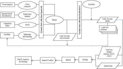
Figure 2. Research framework of the study
To address spectral confusion, binary masking using spectral indices was implemented. Vegetation was identified using the Normalized Difference Vegetation Index (NDVI):
$N D V I=(N I R-R e d) /(N I R+R e d)$ (4)
where, NIR = Band 8 (842 nm) and Red = Band 4 (665 nm) from Sentinel-2 imagery [20]. Water bodies were extracted using the Normalized Difference Water Index (NDWI):
$N D W I=(Green -N I R) /( Green +N I R)$ (5)
where, Green = Band 3 (560 nm) and NIR = Band 8. Thresholds were set as follows: NDVI > 0.3 for vegetation, NDWI > 0 for water, with masking rules defined by:
$Final \,\, Mask=(NDVI \,\,mask \,\, AND \,\, NDWI \,\, mask) ORUrban\_mask$ (6)
2.3.4 Accuracy assessment
Ground verification consisted of ground checks and ground truthing to ensure classification accuracy. Coordinates were selected using purposive sampling, based on accessibility, and checked via field visits and Google Earth interpretation. Sample size for validation was calculated using the cross-sectional formula [21]:
$N=\frac{Z^2[p(1-p)]}{E^2}$ (7)
with Z = 1.645 (for 85% confidence), p = 0.85, E = 0.04, yielding an estimated minimum of 216 samples. A total of 250 validation points were surveyed in April 2024, two months after imagery acquisition. For inaccessible areas, visual interpretation with color composites and high-resolution photography was used. Classification accuracy was evaluated using a confusion matrix, with metrics including errors of commission and omission, Overall Accuracy (OA), and Kappa Accuracy (KA) [22]. Definitions and formulas include:
$User ' s \,\,accuracy (\%)=100 \%- \text{error of commission (%)}$ (8)
$Producer ' s\,\, \text{accuracy (%)}=100 \% - \text{error of omission (%)}$ (9)
$Kappa=\frac{N \sum_{i=1}^r n_{i i}-\sum_{i=1}^r\left(n_{i+} n_{+i}\right)}{N^2-\sum_{i=1}^r\left(n_{i+} n_{+i}\right)}$ (10)
$Overall \,\, accuracy(O A)=\frac{\sum_{i=1}^r n_{i i}}{N} \times 100 \%$ (11)
where, N is the total number of observations, nii is the diagonal cell value for class i, ni+and n+i are the row and column totals, respectively [23]. A 3×3 majority filter was applied in post-processing to reduce salt-and-pepper noise, with a minimum threshold of 5 out of 9 pixels required for class retention. In accordance with Law No. 26/2007 on Spatial Planning, land use is classified into protected and cultivation functions. Protected areas serve to conserve natural and cultural resources, while cultivation zones are designated for productive use based on environmental potential. Land use conflicts often arise from spatial mismatches between zoning functions and actual land use. Land use—defined as human activity on a given plot—includes broad categories such as agriculture, settlement, industry, and mining, as well as specific uses like rice fields, oil palm plantations, aquaculture, and erosion plots [8]. Spatial matching analysis is necessary to understand both the extent and impact (positive or negative) of such land use-function conflicts.
2.3.5 Data compilation and analysis
Data compilation and analysis involve organizing grouped and tabulated information to understand baseline conditions in the Malino Ecotourism Area, including land conversion rates, resource conditions, and projected impacts of land use change. Both manual and GIS-based methods are used, with remote sensing and GIS technologies applied for efficient, large-scale spatial data processing [24, 25]. Validation of image interpretation is carried out in two stages: ground check—by selecting 10 stakeholders purposively from the Regional Spatial Planning Agency (Dinas Tata Ruang), Regional Development Planning and Research Agency (Bappelitbangda), Forestry and Environmental Agency (Dinas Kehutanan dan Lingkungan Hidup), the Tourism Office (Dinas Pariwisata) and academician for field verification—and ground truthing, which uses Google Earth for accuracy checking. The sample size is based on purposive selection of these key informants rather than a cross-sectional formula.
2.4 Analysis of spatial conflicts
The spatial conflicts analysis approach is implemented through overlay techniques between regional spatial planning documents and existing land use conditions interpreted from Sentinel-2 satellite imagery, focusing on the Provincial Strategic Area of Malino Nature Tourism Park (TWA Malino) in Gowa Regency, South Sulawesi. Initial procedures include acquisition of Sentinel-2 Level 2A data with cloud cover criteria below 10% from the Copernicus Open Access Hub [26], Gowa Regency spatial planning documents in shapefile vector format, and other supporting datasets. Image processing stages encompass radiometric and atmospheric correction processes using the Sen2Cor processor [27], multispectral band composites, and projection system transformation to UTM WGS84. Land use information extraction is conducted using supervised classification approaches with Maximum Likelihood or Random Forest algorithms [28, 29], enhanced by utilizing spectral band combinations and NDVI to optimize interpretation accuracy [20]. Classification outputs are subsequently converted into spatial layers of Land Use for 2024 in shapefile format, aligned with the Gowa Regency spatial planning data structure. Land use categorization is adjusted to the spatial planning classification scheme forest, bare land, mixed plantation, dry land plantation, settlement, shrub, river, and ricefield, following the Indonesian National Standard for Land Use Classification [30, 31]. Classification accuracy evaluation is implemented through a confusion matrix with a minimum success standard of 80% [32, 33].
Spatial overlay implementation is executed using the "Union" function in ArcGIS software through the Geoprocessing menu to generate an integrated layer that combines Gowa Regency spatial planning information with 2024 land use data in the TWA Malino area [34, 35]. The overlay operation sequence includes preparation stages of Gowa Regency spatial planning and 2024 land use shapefiles, importing both layers into the ArcGIS environment, and executing the Union tool with input feature class configuration using both layers and establishing the output feature class as the storage directory for overlay results. Spatial conflict detection is performed through evaluation of attribute tables from Union operation results that display overlays between spatial planning categories (such as "Horticulture") with actual land use categories (such as "Forest"), then classified into four inconsistency levels: Appropriate, Less Appropriate, Warning, and Not Allowable, considering the special characteristics of provincial strategic areas with conservation and nature tourism functions [36, 37].
The results validation process is conducted through field verification at selected inconsistency location samples using stratified random sampling methods in the TWA Malino area to verify actual field conditions [38, 39]. Field documentation is implemented through photographic documentation and GPS coordinate recording with accuracy standards following the Global Positioning System guidelines [40, 41], along with in-depth interviews with local stakeholders, including park managers and surrounding communities, to obtain comprehensive contextual data. Final outputs include spatial inconsistency distribution maps with informative symbology systems following cartographic design principles [41, 42], statistical tabulations of inconsistency distribution per administrative unit, and quantitative analysis of Gowa Regency spatial planning implementation compliance levels, particularly in the TWA Malino provincial strategic area. Inconsistency quantification is performed by calculating the proportion of inconsistency area per administrative unit and formulating inconsistency level indices with a 0-1 scale based on attribute table analysis showing combinations of spatial planning and land use classes. Results interpretation encompasses identification of primary inconsistency determinant factors, evaluation of spatial policy implementation effectiveness, and formulation of technical and policy recommendations for sustainable spatial inconsistency resolution utilizing spatial data from Union overlay results. This methodology provides a structured and reproducible framework to support decision-making processes in more optimal and sustainable spatial planning [43, 44].
3.1 Land use dynamics
The spatial distribution of land use in the study area is presented in Figure 3, while the error matrix resulting from the accuracy assessment procedure is shown in Table 3, which displays both types of accuracy (user’s and producer’s), as further illustrated in Figure 4. Based on the User’s and Producer’s Accuracy graphs, most land use classes exhibit excellent classification performance with accuracies above 80%. The Forest class demonstrates the highest performance, with both types of accuracy approaching 100% (97.1% and 99.0%), followed by Mixed Agriculture and Ricefield, which also show very high accuracy (> 94%). However, two classes pose classification challenges: first, Settlements & Activity Areas, which have the lowest accuracy, particularly in Producer’s Accuracy (66.7%), indicating that many settlement areas were not detected—possibly due to spectral similarity with surrounding vegetation; and second, Shrubs, which show a significant gap between User’s Accuracy (94.4%) and Producer’s Accuracy (81.0%), suggesting that although areas classified as shrubs are generally correct, many shrub areas were not identified and may have been misclassified as other vegetation classes. Overall, with a total accuracy of 94% and a Kappa coefficient of 0.920, the classification results demonstrate excellent quality and reliability for most remote sensing applications.

2015

2016

2019

2020

2021

2023

2024

Spatial Plan of Gowa Regency
Figure 3. Land use change over time and the spatial plan of Gowa Regency
Table 3. Land use in Malino ecotourism strategic area (2015–2024)
|
No. |
Land Use Category |
2015 |
2016 |
2019 |
2020 |
2021 |
2023 |
2024 |
|
1 |
Forest |
5,125.78 |
5,123.54 |
5,334.64 |
5,255.08 |
5,327.50 |
4,939.94 |
4,938.59 |
|
2 |
Bare Land |
477.59 |
477.59 |
408.38 |
404.67 |
409.68 |
409.68 |
409.68 |
|
3 |
Mix Plantation |
1,929.32 |
1,929.32 |
1,938.80 |
1,981.62 |
1,980.57 |
1,978.94 |
1,978.86 |
|
4 |
Dryland Plantation |
2,208.15 |
2,208.15 |
2,191.25 |
2,304.41 |
2,249.49 |
2,249.24 |
2,252.83 |
|
5 |
Settlement |
525.16 |
525.16 |
551.51 |
561.41 |
566.83 |
570.99 |
573.92 |
|
6 |
Shrub |
791.61 |
793.84 |
633.02 |
609.01 |
546.40 |
933.19 |
929.56 |
|
7 |
River |
81.08 |
81.08 |
81.08 |
81.22 |
81.41 |
81.41 |
81.41 |
|
8 |
RiceField |
1,027.64 |
1,027.64 |
1,027.64 |
969.23 |
1,005.10 |
1,003.59 |
1,002.13 |

Figure 4. Users’ and producers’ accuracies of land use figure
Understanding the actual conditions of land use is essential for identifying deviations from the official spatial planning and assessing the sustainability of landscape changes over time. In the case of Malino Ecotourism Area, land use dynamics between 2015 and 2024 reflect ongoing transformations driven by tourism development, population growth, and agricultural intensification. These shifts reveal both pressures and opportunities in balancing conservation, economic development, and land management.
The data show that forest areas in the Malino Ecotourism Strategic Area experienced fluctuations between 2015 and 2024. The forest area increased from 5,125.78 hectares in 2015 to 5,334.64 hectares in 2019, but then declined significantly to 4,938.59 hectares in 2024, indicating a deforestation of 187.19 hectares (3.65%) over the nine-year period. Fluctuations peak in 2019, followed by a continuous decline through 2024, resulting in a net loss of approximately 187 hectares. This downward trend indicates growing deforestation pressures, likely driven by agricultural expansion and infrastructure development to support tourism. Simultaneously, settlements increased steadily from 525.16 hectares to 573.92 hectares, reflecting the rise in population and the growing popularity of Malino as a tourism and residential destination. These patterns suggest ongoing urban-rural transition processes typical in highland ecotourism areas.
This reflects significant land conversion pressure in highland regions like Malino, driven by tourism growth and high-value agriculture. Residential areas also expanded steadily from 525.16 hectares in 2015 to 573.92 hectares in 2024, an increase of 48.76 hectares (9.29%), aligning with the trend of mountain destinations becoming migration targets due to cooler climates, scenic landscapes, and tourism development potential. The most notable fluctuation occurred in shrubland, which decreased from 791.61 hectares in 2015 to 546.40 hectares in 2021, then rose sharply to 929.56 hectares by 2024. This surge suggests land abandonment or forest degradation triggered by extreme weather patterns and declining soil fertility, as farmers leave the land uncultivated. Agricultural areas—combining plantations/gardens, dryland farming, and rice fields—remained relatively stable with minor variations. Plantations grew slightly from 1,929.32 hectares to 1,978.86 hectares, while rice fields declined from 1,027.64 hectares to 1,002.13 hectares, reflecting a shift among highland farmers from traditional food crops like rice to high-value horticultural and plantation commodities. This transition is driven by better economic opportunities, market preference shifts, and climate-related productivity challenges for traditional rice farming. Meanwhile, barren land areas decreased from 477.59 hectares in 2015 to 409.68 hectares in 2024, possibly due to land rehabilitation efforts or conversion into other land uses.
The observed decrease in vacant or barren land from nearly 478 hectares in 2015 to about 409 hectares in 2024 may suggest either rehabilitation efforts or conversion to other land uses, including settlements or agriculture. The slight decline in rice field areas, despite the overall stability in total agricultural land, may indicate a transition from traditional paddy cultivation to horticultural crops with higher economic returns. These trends emphasize the complexity of land dynamics in Malino and underline the need for integrated planning approaches that align spatial development with conservation and climate resilience priorities.
Land use changes in the Malino Ecotourism Strategic Area during the 2015–2024 period indicate increasing pressure on forest areas, expansion of residential zones, and dynamic shifts in agricultural and shrubland areas, reflecting socio-economic and environmental transformations in the region. This highlights the urgent need for more sustainable and integrated land management policies to minimize the negative impacts of land use change.
Table 4. Land use in the Malino ecotourism strategic area, using 250 observations (2015–2024)
|
Land Use |
BL |
DL |
F |
MA |
R |
SA |
S |
Total |
EC |
|
Bare Land (BL) |
11 |
1 |
0 |
0 |
0 |
0 |
1 |
13 |
0.154 |
|
Dry Land Agriculture (DL) |
2 |
38 |
0 |
0 |
0 |
1 |
1 |
42 |
0.095 |
|
Forest (F) |
0 |
0 |
102 |
0 |
0 |
1 |
2 |
105 |
0.029 |
|
Mixed Agriculture (MA) |
0 |
1 |
0 |
45 |
0 |
1 |
0 |
47 |
0.043 |
|
Ricefield (R) |
0 |
0 |
0 |
1 |
16 |
0 |
0 |
17 |
0.059 |
|
Settlements & Activity Areas (SA) |
0 |
1 |
0 |
0 |
1 |
6 |
0 |
8 |
0.250 |
|
Shrubs (S) |
0 |
0 |
1 |
0 |
0 |
0 |
17 |
18 |
0.056 |
|
Total |
13 |
41 |
103 |
46 |
17 |
9 |
21 |
250 |
|
|
EO |
0.154 |
0.073 |
0.010 |
0.022 |
0.059 |
0.333 |
0.190 |
0.064 |
Table 4 presents the confusion matrix for land use classification in the Malino Ecotourism Strategic Area from 2015 to 2024, comprising seven land use categories with a total of 250 validation points. The Forest class exhibited the highest classification accuracy with only 1% commission error and 2.9% omission error, indicating excellent classifier performance. Similarly, Mixed Agriculture and Dry Land Agriculture showed strong agreement between classification and ground truth, with low error rates. In contrast, Settlements & Activity Areas had the highest commission error (25.0%) and a notable omission error (33.3%), suggesting frequent misclassification—likely due to spectral similarity with surrounding vegetation. Shrubs also displayed moderate error rates (5.6% commission, 19.0% omission), reflecting difficulties in distinguishing low-growing vegetation. Despite these challenges, the classification achieved an OA of 94% and a Kappa coefficient of 0.920, confirming a high level of reliability and robustness for remote sensing-based land use mapping in the study area.
3.2 Land use conflict: Spatial utilization conflict
The spatial utilization conflict in Malino Ecotourism Area arises from overlapping interests among tourism, agriculture, and conservation sectors. The development of tourism facilities has led to the conversion of agricultural lands into commercial areas, resulting in tensions between local communities and tourism developers. Frequently, territorial disputes emerge due to changes in land status and restrictions on crop types in certain areas, which limit the local population's economic activities. Moreover, the competition over land control between local residents and investors adds to the complexity of land use conflict. From a spatial perspective, conflict is likely to occur when there is a mismatch between the designated spatial planning and the actual land use. Spatial analysis reveals that the land use in Malino Ecotourism Area is divided into several functional zones. Table 5 presents potential conflicts caused by inconsistencies between land use planning (RTRW) and actual land use conditions, categorized by suitability level, total area, and its percentage.
Table 5 presents a detailed spatial conflict analysis by overlaying land use categories with zoning designations in the Malino Ecotourism Strategic Area (KSP Malino), based on conformity levels ranging from "Appropriate" to "Not Allowable." The most severe conflicts appear within Conservation Forest zones, where several non-conforming land uses are identified as “Not Allowable,” such as Shrubs (645.20 ha), Mixed Agriculture (494.06 ha), Dry Land Agriculture (226.70 ha), and Settlements & Activity Areas (32.36 ha). These data suggest substantial encroachment into areas legally designated for conservation, particularly through agricultural expansion and informal settlement growth. Additionally, the presence of Ricefields (29.28 ha) and River modification (23.65 ha) within these zones further reflects violations of ecological preservation mandates. Likewise, Limited Production Forests, although partially designated for cultivation, also show troubling levels of incompatible land use—especially in Forest (2,071.30 ha) and Shrubs (178.86 ha)—indicating intensifying pressure and fragmentation in what should be semi-regulated forest production landscapes.
Table 5. Potential land use conflict in KSP Malino
|
Bare Land |
Dry Land Agriculture |
Forest |
Mixed Agriculture |
Ricefield |
River |
Settlements & Activity Areas |
Shrubs |
|
|
Agroforestry |
0.34 |
113.42 |
85.57 |
120.32 |
28.01 |
1.62 |
5.30 |
14.61 |
|
Conservation Forest |
394.25 |
226.70 |
2,461.81 |
494.06 |
29.28 |
23.65 |
32.36 |
645.20 |
|
Horticulture |
3.71 |
642.47 |
117.98 |
418.79 |
137.93 |
20.81 |
74.37 |
26.85 |
|
Limited Production Forest |
2.49 |
718.35 |
2,071.30 |
354.92 |
84.69 |
4.34 |
60.58 |
178.86 |
|
Plantation |
3.63 |
59.79 |
112.79 |
248.68 |
33.50 |
13.50 |
139.77 |
39.87 |
|
Protected forest |
0.38 |
0.15 |
3.20 |
0.19 |
0.01 |
|
0.06 |
|
|
Residential |
0.03 |
104.55 |
15.23 |
36.29 |
0.30 |
0.26 |
189.61 |
0.01 |
|
Water Body |
0.79 |
2.72 |
7.68 |
1.26 |
0.45 |
6.56 |
0.06 |
2.47 |
|
Wetland Agriculture |
4.06 |
384.66 |
63.03 |
304.36 |
687.95 |
10.67 |
71.80 |
21.69 |
| Appropriate | |
| Less Appropriate | |
| Warning | |
| Not Allowable | |
| Not Applicable |

Figure 5. Spatial conflict map based on land use suitability in KSP Malino
Moderate to conditional conflicts categorized as "Warning" (yellow) and "Less Appropriate" (light green) are particularly prevalent in Horticulture, Plantation, and Residential zones. For instance, horticultural areas host a wide variety of land uses, including Dry Land Agriculture (642.47 ha) and Mixed Agriculture (418.79 ha), which may initially appear acceptable due to their cultivation functions but could result in long-term degradation or unsustainable land conversion if not carefully managed. In contrast, several “Appropriate” land use patterns—shown in green—demonstrate proper alignment with zoning regulations, most notably in Wetland Agriculture, where Ricefields (687.95 ha) and Mixed Agriculture (304.36 ha) are dominant, as well as Forests (2,071.30 ha) in Limited Production Forests. These conformities affirm the validity of the spatial plan in select areas, though they are outweighed by the cumulative area under conflict. The findings underscore the need for urgent policy intervention, improved monitoring, and strict enforcement of spatial zoning, particularly within conservation and limited production forest zones, to prevent further ecological degradation and to ensure that tourism development in Malino aligns with sustainable land governance frameworks.
Figure 5 visualizes the spatial distribution of land use suitability in the Malino Ecotourism Strategic Area, highlighting zones of alignment and conflict with spatial planning regulations. Areas shaded in green represent land uses classified as “Appropriate,” indicating conformity with designated zoning functions, and are predominantly found in the northern and northeastern regions. Yellow areas, denoting “Warning” and “Less Appropriate” uses, appear scattered across central and northeastern zones, reflecting moderate spatial mismatches that may lead to future degradation if unmanaged. In contrast, red areas—classified as “Not Allowable”—are heavily concentrated in the southern and central parts of the landscape, where land use practices significantly violate spatial designations, particularly in conservation and forest zones. These red zones signify critical hotspots for land use conflict, including encroachment by settlements, agriculture, or other non-permitted activities. The map underscores the urgency of spatial governance reform, especially in enforcing land use regulations and mitigating further ecological disturbance in high-conflict zones.
3.3 Stakeholder interest: Conflicts in the development of Malino nature tourism park
The development of TWA Malino involves multiple stakeholders with differing interests (Table 6), leading to complex conflicts. National ministries focus on conservation (Environment and Forestry) and tourism development (MoTCE), often with contrasting priorities—ecological protection versus economic growth. Regional and local governments emphasize tourism-driven income and employment, pushing infrastructure and permits that may overlook environmental limits. This divergence creates tension in zoning, planning, and policy coordination. Local communities seek economic welfare and resource access while supporting sustainable practices, yet often lack full participation in decision-making. The private sector prioritizes profit through tourism investment and facility expansion, while NGOs and academics advocate for biodiversity protection and sustainable management. Conflicts arise from overlapping authority, weak coordination in permits, and unclear revenue-sharing—undermining efforts to balance tourism and conservation.
Table 6. Potential cross-sectoral conflicts in Malino Nature Tourism Park (TWA Malino)
|
No. |
Type of Conflict |
Government vs Local Communities |
Private Sector vs Conservation |
Inter-Community Conflicts |
Data Source |
|
1 |
Access to Natural Resources |
√ |
|
|
Interview, Observation |
|
2 |
Distribution of Economic Benefits |
√ |
|
|
Interview, Documentation (RPJMD Gowa 2021–2026) |
|
3 |
Participation in Decision-Making |
√ |
|
|
Interview, Community Meeting Records |
|
4 |
Infrastructure Development |
|
√ |
|
Spatial Planning Documents (RTRW Gowa 2022) |
|
5 |
Intensity of Resource Utilization |
|
√ |
|
Observation, EIA Reports |
|
6 |
Time Orientation (Short-term vs Long-term Goals) |
|
√ |
|
Strategic Tourism Plan |
|
7 |
Business Competition among Local Actors |
|
|
√ |
Interview, Community Economic Data |
|
8 |
Diverging Conservation Perspectives |
|
|
√ |
NGO Reports, Focus Group Discussion |
Conflicts between government authorities and local communities tend to revolve around resource access, unequal benefit sharing, and limited involvement in planning processes. While governments seek to implement regional tourism strategies, local communities often struggle to access land or forest areas traditionally used for livelihoods. Furthermore, decision-making processes rarely involve meaningful community participation, resulting in resistance and mistrust toward development initiatives. Private sector conflicts are predominantly shaped by the drive for rapid infrastructure growth, which often neglects environmental limits. These actors emphasize short-term economic gains, leading to intensive land use and disregard for ecological zoning. Overlapping land claims and infrastructure encroachment into core conservation zones illustrate how commercial objectives frequently contradict sustainability principles. These challenges are compounded by weak enforcement of environmental regulations and inadequate coordination with environmental ministries. Intra-community conflicts arise due to uneven economic opportunities and differing views on conservation. Some groups prioritize environmental protection and sustainable tourism, while others are more inclined toward maximizing income, even at the cost of ecological degradation. Business competition further escalates tensions as tourism-related ventures become concentrated among certain groups, marginalizing others and deepening socio-economic divides.
3.4 Value conflicts related to perceptions between local communities and management authorities
The management of the TWA Malino is not only shaped by institutional and operational dynamics but also influenced by value-based conflicts that stem from differing perceptions between local communities and area authorities. These differences revolve around the meaning of conservation, land ownership, access to resources, and the distribution of tourism benefits. While local residents emphasize livelihood security, cultural heritage, and inclusive governance, authorities are more focused on regulatory compliance, ecological preservation, and macro-level tourism development. Table 7 summarizes the key value conflicts, consolidated from interview findings, field observations, and review of relevant regulatory documents.
Table 7. Value-based conflicts between local communities and management authorities
|
No. |
Source of Conflict |
Local Community Perspective |
Authority Perspective |
Description of Conflict |
Source of Data |
|
1 |
Access to Natural Resources |
View access as a right tied to livelihood and tradition |
Limited access based on zoning and conservation rules |
Locals feel their traditional rights are overlooked in resource allocation |
Interview, Field Observation |
|
2 |
Conservation Definition |
Should allow sustainable use that benefits locals |
Defined as protection with limited human interference |
Conflicting interpretations of conservation hinder cooperative land use |
Document Review (UU No. 5/1990, PP No. 28/2011) |
|
3 |
Land Ownership and Control |
Land is communally or ancestrally owned |
Land is state-managed under conservation or forestry jurisdiction |
Disagreements about legal vs. customary land claims generate tension |
Interview, Document Review |
|
4 |
Benefit Distribution from Tourism |
Expect tangible and fair benefit sharing |
Prioritize regional economic growth and investor confidence |
Perceived inequality in revenue distribution creates local dissatisfaction |
Interview, Field Observation |
|
5 |
Role in Decision-Making |
Demand active involvement in planning and governance |
Policies are largely determined top-down by national and provincial levels |
Exclusion from decision-making undermines community trust and cooperation |
Interview, RPJMD, and RIPPARDA Review |
|
6 |
Cultural Practices vs. Regulation |
Cultural activities and land use are seen as part of identity |
Require compliance with formal conservation guidelines |
Cultural traditions are sometimes treated as regulatory violations |
Interview, Field Observation, KLHK Regulation Review |
The value-based conflicts in TWA Malino highlight a fundamental disconnect between local worldviews and formal management structures. Local communities see the forest not just as a resource but as an integral part of their cultural identity and everyday life. They expect policies to accommodate their livelihoods and traditions while ensuring fair participation and benefit-sharing. On the other hand, authorities—bound by legal mandates and national planning agendas—are often focused on strict conservation and tourism expansion targets, which may marginalize local voices. These diverging perspectives contribute to mistrust, non-compliance, and persistent disputes over land, resource use, and governance. Addressing these conflicts requires an inclusive approach that respects indigenous knowledge, fosters co-management, and aligns conservation goals with the socioeconomic needs of local populations.
The analysis of land use conflict in the Malino Ecotourism Area reveals significant inconsistencies between actual land use and spatial planning, particularly in conservation and protected forest zones [45-47]. Agricultural plots, tourism infrastructure, and settlements have encroached on these zones, especially in agroforestry and limited production forest areas [48-50]. This misalignment stems from weak coordination, outdated maps, and overlapping tourism and forestry interests [51-55]. Field verification from 2015–2024 shows forest degradation and conversion of shrubs into settlements, driven by tourism and agricultural pressures [49, 56, 57]. A lack of enforcement capacity and uncontrolled development further intensifies these issues [46, 58-60]. Socio-economic drivers, such as land demand from local communities and investors, exacerbate land use conflicts, particularly in horticultural and plantation zones [56, 61, 62]. The need for harmonizing spatial data, revising RTRW maps, and strengthening compliance mechanisms is urgent [53-55].
Malino’s land use conflicts arise from policy, interest, and value-based disagreements. Policy conflicts occur due to inconsistencies between conservation laws and tourism development mandates [46, 52, 63]. Interest-based conflicts emerge between tourism investors and local farmers over land acquisition, leading to the marginalization of subsistence practices [64, 65]. Value-based conflicts reflect differing land use perspectives between local communities, government authorities, and tourism actors, leading to disputes over land access and decision-making [66, 67]. Operational conflicts occur when tourism activities violate conservation zoning rules, threatening biodiversity [46, 47]. These conflicts highlight the need for conflict-sensitive planning, harmonizing zoning regulations, and institutionalizing multi-stakeholder dialogue [55, 68-71].
The development of TWA Malino is currently at a strategic turning point where moderate internal capacity is confronted with strong external opportunities for sustainable growth. The area’s rich biodiversity, scenic landscapes, and vital ecosystem services form a solid basis for ecotourism development, while the increasing demand for nature-based tourism, initiatives to promote green infrastructure, and the rise of environmental awareness further strengthen its potential [46, 72-74]. At the same time, challenges such as inadequate waste management and limited community capacity continue to hinder optimal development, requiring a shift toward ecologically sensitive strategies that enhance zoning enforcement, foster the construction of eco-friendly tourism facilities, and promote community-based initiatives that align economic benefits with conservation goals [47, 48, 69, 70, 75, 76]. In addition, stricter control of spatial utilization and the prevention of illegal land conversion are needed to minimize environmental pressures, while multi-stakeholder governance and integrated risk management are essential to strengthen resilience and reduce institutional fragmentation [52, 55, 56, 59, 60, 63, 71]. Together, these strategies provide a coherent framework for balancing conservation and tourism development, ensuring that ecological sustainability and local economic growth can advance in synergy.
The findings of this study demonstrate that land use conflicts in the TWA Malino emerge from overlapping interests between conservation, tourism development, and agriculture, resulting in violations of conservation zoning and tensions between local communities and government authorities. These conflicts are further exacerbated by fragmented institutional coordination, differing policy orientations, and unequal distribution of economic benefits. Overlay analysis revealed significant discrepancies between actual land use and official spatial plans of Gowa Regency and South Sulawesi Province, including the conversion of agricultural land into commercial areas and the exploitation of protected forests for tourism. Such mismatches highlight weak spatial control and insufficient enforcement of land use regulations. Despite these challenges, the area holds strong potential for sustainable tourism growth if development is directed toward balancing conservation and tourism. This requires strengthening ecological zoning in line with the minimum 30% green space requirement, promoting eco-friendly infrastructure, and enhancing local community participation in conservation governance. At the same time, multi-stakeholder coordination must be reinforced through joint regulations and regular forums to harmonize the interests of the Ministry of Environment and Forestry, the Ministry of Tourism, and local governments. By implementing geospatial monitoring systems and imposing firm sanctions on violations, local governments can uphold the integrity of spatial plans and long-term sustainability. Finally, the future development of TWA Malino should emphasize ecotourism and agrotourism based on community involvement, supported by capacity-building programs, tourism awareness groups, and the application of green technology to empower local communities while safeguarding ecological resilience and promoting sustainable economic growth.
[1] Thapa, K., King, D., Banhalmi-Zakar, Z., Diedrich, A. (2022). Nature-based tourism in protected areas: A systematic review of socio-economic benefits and costs to local people. International Journal of Sustainable Development & World Ecology, 29(7): 625-640. https://doi.org/10.1080/13504509.2022.2073616
[2] Borah, A. (2025). Tourism, livelihoods and landscape change: A GIS-based study of land use dynamics in Nameri National Park, Assam. In Advances in Social Science, Education and Humanities Research, pp. 978-990. https://doi.org/10.2991/978-2-38476-533-1_58
[3] Pandya, R., Dev, H.S., Rai, N.D., Fletcher, R. (2022). Rendering land touristifiable: (Eco)tourism and land use change. Tourism Geographies, 25(4): 1068-1084. https://doi.org/10.1080/14616688.2022.2077425
[4] Gao, Y., Yin, R., Chai, J., Li, Z., Deng, X. (2025). Landscape management strategy for cultivated land ecosystem: New evidence from differentiation of supply and demand dynamics. Environmental Impact Assessment Review, 115: 107980. https://doi.org/10.1016/J.EIAR.2025.107980
[5] Huang, X., Wang, H., Wang, C., Wu, J., Yi, S. (2025). Understanding the spatio-temporal relationships and drivers of cultivated land multifunction supply-demand mismatch towards targeted cultivated land management. Land Degradation & Development. https://doi.org/10.1002/ldr.70295
[6] Singh, V. (2024). The environment and its components. In Textbook of Environment and Ecology, pp. 1-13. https://doi.org/10.1007/978-981-99-8846-4_1
[7] Mir, Y.H., Mir, S., Ganie, M.A., Bhat, J.A., Shah, A.M., Mushtaq, M., Irshad, I. (2025). Overview of land use and land cover change and its impacts on natural resources. In Sustainable Development and Biodiversity, pp. 101-130. https://doi.org/10.1007/978-981-96-2413-3_5
[8] Baja, S. (2012). Perencanaan Tata Guna Lahan Dalam Pengembangan Wilayah. Penerbit Andi, Yogyakarta.
[9] Baja, S. (2012). Metode analitik evaluasi sumber daya lahan: Aplikasi GIS, fuzzy set, dan MCDM. Identitas Universitas Hasanuddin.
[10] Jain, A., Babu K., D.A. (2025). Urban green spaces and their indispensable necessity in the context of cities experiencing rapid urbanization in India: An analysis of current trends and future implications. International Journal of Environmental Pollution and Environmental Modelling, 8(2): 122-134.
[11] Briassoulis, H. (2020). Analysis of land use change: Theoretical and modeling approaches. WVU Research Repository.
[12] Popovici, E.A., Balteanu, D., Kucsicsa, G. (2013). Assessment of changes in land-use and land-cover pattern in Romania using CORINE land use database. Carpathian Journal of Earth and Environmental Sciences, 8(4): 195-208.
[13] Indrayati, A., Rijanta, R., Muta'ali, L., Rachmawati, R. (2023). Built-up area changes, spatial pattern and urban sprawling in Kedungsepur metropolitan area. International Journal of Sustainable Development and Planning, 18(8): 2541-2546. https://doi.org/10.18280/ijsdp.180825
[14] Regasa, M.S., Nones, M. (2021). A review on land use and land cover change in Ethiopian basins. https://doi.org/10.20944/PREPRINTS202105.0225.V1
[15] Baja, S., Pulubuhu, D.A.T., Neswati, R., Arif, S., Nurmiaty. (2019). Land use conflict with a particular reference to spatial planning implementation in South Sulawesi. IOP Conference Series: Earth and Environmental Science, 279: 012006. https://doi.org/10.1088/1755-1315/279/1/012006
[16] Abbas, J., Baja, S., Neswati, R., Yamin, M., Rahmat, S. (2024). Social network interaction mapping and the impact of land use change in Malino tourism area, Gowa Regency, Indonesia. IOP Conference Series: Earth and Environmental Science, 1430(1): 012011. https://doi.org/10.1088/1755-1315/1430/1/012011
[17] Kohsaka, R., Matsuoka, H., Uchiyama, Y., Rogel, M. (2019). Regional management and biodiversity conservation in GIAHS: Text analysis of municipal strategy and tourism management. Ecosystem Health and Sustainability, 5(1): 124-132. https://doi.org/10.1080/20964129.2019.1610336
[18] Richards, J.A., Jia, X. (2006). Remote Sensing Digital Image Analysis: An Introduction (4th ed.). Springer.
[19] Swain, P.H., Davis, S.M. (1978). Remote Sensing: The Quantitative Approach. New York: McGraw Hill Book Company.
[20] Rouse, J.W., Haas, R.H., Schell, J.A., Deering, D.W. (1974). Monitoring vegetation systems in the Great Plains with ERTS. Third Earth Resources Technology Satellite-1 Symposium: 309-317. https://ntrs.nasa.gov/citations/19740022614.
[21] Eastman, J.R., Jin, W., Kyem, P.K., Toledano, J. (1993). Raster procedures for multicriteria/multiobjective decisions. Photogrammetric Engineering and Remote Sensing, 61: 539-547.
[22] Scepan, J. (1999). Thematic validation of high-resolution global land-cover data sets. Photogrammetric Engineering and Remote Sensing, 65: 1051-1060.
[23] Foody, G.M. (2002). Status of land cover classification accuracy assessment. Remote Sensing of Environment, 80(1): 185-201. https://doi.org/10.1016/S0034-4257(01)00295-4
[24] Armenteras, D., Gast, F., Villareal, H. (2003). Andean forest fragmentation and the representativeness of protected natural areas in the eastern Andes, Colombia. Biological Conservation, 113(2): 245-256. https://doi.org/10.1016/S0006-3207(02)00359-2
[25] Franklin, S.E. (2001). Remote Sensing for Sustainable Forest Management. CRC Press. https://doi.org/10.1201/9781420032857
[26] European Space Agency. (2015). Sentinel-2 user handbook. ESA.
[27] Müller-Wilm, U., Louis, J., Richter, R., Gascon, F., Niezette, M. (2016). Sen2Cor configuration and user manual. Telespazio VEGA Deutschland GmbH. https://step.esa.int/thirdparties/sen2cor/2.3.0/[L2A-SUM]%20S2-PDGS-MPC-L2A-SUM%20[2.3.0].pdf.
[28] Breiman, L. (2001). Random forests. Machine Learning, 45(1): 5-32. https://doi.org/10.1023/A:1010933404324
[29] Mountrakis, G., Im, J., Ogole, C. (2011). Support vector machines in remote sensing: A review. ISPRS Journal of Photogrammetry and Remote Sensing, 66(3): 247-259. https://doi.org/10.1016/J.ISPRSJPRS.2010.11.001
[30] BSN. (2010). Klasifikasi penutup lahan (SNI 7645:2010). https://repository.unikom.ac.id/44316/1/15.%20SNI%207645-2010%20Klasifikasi%20penutup%20lahan.pdf.
[31] Magdalena, R., Saidah, S., Pratiwi, N.K.C., Putra, A.T. (2021). Klasifikasi tutupan lahan melalui citra satelit SPOT-6 dengan metode convolutional neural network (CNN). Jurnal Edukasi dan Penelitian Informatika (JEPIN), 7(3): 335. https://doi.org/10.26418/jp.v7i3.48195
[32] Congalton, R.G., Green, K. (2019). Assessing the Accuracy of Remotely Sensed Data: Principles and Practices (3rd ed.). Boca Raton: CRC Press.
[33] Mashala, M.J., Dube, T., Mudereri, B.T., Ayisi, K.K., Ramudzuli, M.R. (2023). A systematic review on advancements in remote sensing for assessing and monitoring land use and land cover changes impacts on surface water resources in semi-arid tropical environments. Remote Sensing, 15(16): 3926. https://doi.org/10.3390/rs15163926
[34] ESRI. (2023). ArcGIS Pro 3.1 user guide. ESRI Press. https://www.esri.com/en-us/esri-press/browse/gis-tutorial-for-arcgis-pro-3-1.
[35] Kapoor, N., Bansal, V.K. (2023). Planning at site-level in hill regions using geodesign-based approach. International Review for Spatial Planning and Sustainable Development, 11(4): 1-18. https://doi.org/10.14246/irspsd.11.4_1
[36] Longley, P.A., Rhind, D.W. (2015). Geographic Information Science and Systems (4th ed.). Hoboken: John Wiley & Sons.
[37] Nyoni, R., Pangapanga-Phiri, I., Undi, J., Mwangomba, I., Ruiz Peyré, F. (2025). Innovative strategies for balancing conservation and tourism in highland areas: The case of Uzumara Forest Reserve-Rumphi in Malawi. Sustainable Earth Reviews, 8(1). https://doi.org/10.1186/S42055-025-00112-2
[38] Cochran, W.G. (1977). Sampling Techniques (3rd ed.). New York: John Wiley & Sons.
[39] Azis, N.D.C., Herman, H., Niswaty, R. (2024). Malino tourism development strategy in improving regional original income in the tourism and culture service of Gowa Regency. International Journal of Public Policy and Bureaucracy, 1(1): 77-96.
[40] Hofmann-Wellenhof, B., Lichtenegger, H., Wasle, E. (2008). GNSS--Global Navigation Satellite Systems: GPS, GLONASS, Galileo, and More. Vienna: Springer.
[41] Lamsal, B. (2025). Development of an indoor localization and positioning system in non-GPS environment using standalone smart phones and its implementation in construction site photo management application. Proceedings of Digital Frontiers in Buildings and Infrastructure International Conference Series, 2025: 13-23. https://doi.org/10.66408/dfbi.2025.2520
[42] Slocum, T.A., McMaster, R.B., Kessler, F.C., Howard, H.H. (2009). Thematic Cartography and Geovisualization (3rd ed.). Upper Saddle River: Prentice Hall.
[43] Klosterman, R.E. (1999). The what if? Collaborative planning support system. Environment and Planning B: Planning and Design, 26(3): 393-408. https://doi.org/10.1068/B260393
[44] Malczewski, J. (2004). GIS-based land-use suitability analysis: A critical overview. Progress in Planning, 62(1): 3-65. https://doi.org/10.1016/J.PROGRESS.2003.09.002
[45] Oldekop, J.A., Holmes, G., Harris, W.E., Evans, K.L. (2015). A global assessment of the social and conservation outcomes of protected areas. Conservation Biology, 30(1): 133-141. https://doi.org/10.1111/cobi.12568
[46] Geldmann, J., Manica, A., Burgess, N.D., Coad, L., Balmford, A. (2019). A global-level assessment of the effectiveness of protected areas at resisting anthropogenic pressures. Proceedings of the National Academy of Sciences, 116(46): 23209-23215. https://doi.org/10.1073/pnas.1908221116
[47] Maxwell, S.L., Cazalis, V., Dudley, N., Hoffmann, M., et al. (2020). Area-based conservation in the twenty-first century. Nature, 586(7828): 217-227. https://doi.org/10.1038/s41586-020-2773-z
[48] Leung, Y.F., Spenceley, A., Hvenegaard, G., Buckley, R. (2018). Tourism and visitor management in protected areas: Guidelines for sustainability. IUCN, International Union for Conservation of Nature, (27). https://doi.org/10.2305/iucn.ch.2018.pag.27.en
[49] Chen, G., Li, X., Liu, X., Chen, Y., Liang, X., Leng, J., Xu, X., Liao, W., Qiu, Y., Wu, Q., Huang, K. (2020). Global projections of future urban land expansion under shared socioeconomic pathways. Nature Communications, 11(1). https://doi.org/10.1038/s41467-020-14386-x
[50] Li, G., Fang, C., Li, Y., Wang, Z., Sun, S., He, S., Qi, W., Bao, C., Ma, H., Fan, Y., Feng, Y., Liu, X. (2022). Global impacts of future urban expansion on terrestrial vertebrate diversity. Nature Communications, 13(1). https://doi.org/10.1038/s41467-022-29324-2
[51] Gaveau, D.L.A., Pirard, R., Salim, M.A., Tonoto, P., Yaen, H., Parks, S.A., Carmenta, R. (2016). Overlapping land claims limit the use of satellites to monitor no-deforestation commitments and no-burning compliance. Conservation Letters, 10(2): 257-264. https://doi.org/10.1111/conl.12256
[52] Golden Kroner, R.E., Qin, S., Cook, C.N., Krithivasan, R., et al. (2019). The uncertain future of protected lands and waters. Science, 364(6443): 881-886. https://doi.org/10.1126/science.aau5525
[53] Unger, E.M., Bennett, R.M., Lemmen, C., Zevenbergen, J. (2021). LADM for sustainable development: An exploratory study on the application of domain-specific data models to support the SDGs. Land Use Policy, 108: 105499. https://doi.org/10.1016/j.landusepol.2021.105499
[54] Rahman, M.M., Szabó, G. (2023). Assessing the status of national spatial data infrastructure (NSDI) of Bangladesh. ISPRS International Journal of Geo-Information, 12(6): 236. https://doi.org/10.3390/ijgi12060236
[55] Chen, M., Van Oosterom, P., Kalogianni, E., Dijkstra, P., Lemmen, C. (2024). Bridging sustainable development goals and land administration: The role of the ISO 19152 Land Administration Domain Model in SDG indicator formalization. Land, 13(4): 491. https://doi.org/10.3390/land13040491
[56] Curtis, P.G., Slay, C.M., Harris, N.L., Tyukavina, A., Hansen, M.C. (2018). Classifying drivers of global forest loss. Science, 361(6407): 1108-1111. https://doi.org/10.1126/science.aau3445
[57] Bullock, E.L., Woodcock, C.E., Souza, Jr., C., Olofsson, P. (2020). Satellite-based estimates reveal widespread forest degradation in the Amazon. Global Change Biology, 26(5): 2956-2969. https://doi.org/10.1111/gcb.15029
[58] Critchlow, R., Plumptre, A.J., Alidria, B., Nsubuga, M., Driciru, M., Rwetsiba, A., Wanyama, F., Beale, C.M. (2016). Improving law-enforcement effectiveness and efficiency in protected areas using ranger-collected monitoring data. Conservation Letters, 10(5): 572-580. https://doi.org/10.1111/conl.12288
[59] Slough, T., Kopas, J., Urpelainen, J. (2021). Satellite-based deforestation alerts with training and incentives for patrolling facilitate community monitoring in the Peruvian Amazon. Proceedings of the National Academy of Sciences, 118(29): e2015171118. https://doi.org/10.1073/pnas.2015171118
[60] Hockings, M., Hardcastle, J., Woodley, S., Sandwith, T., Wilson, J., Bammert, M., Valenzuela, S., Chataigner, B., Lefebvre, T., Leverington, F., Lopoukhine, N., MacKinnon, K., Miranda Lodoño, J. (2019). The IUCN Green List of protected and conserved areas: Setting the standard for effective conservation. PARKS, 25.2: 57-66. https://doi.org/10.2305/IUCN.CH.2019.PARKS-25-2MH.en
[61] Busch, J., Ferretti-Gallon, K. (2017). What drives deforestation and what stops it? A meta-analysis. Review of Environmental Economics and Policy, 11(1): 3-23. https://doi.org/10.1093/reep/rew013
[62] Lenzen, M., Sun, Y.Y., Faturay, F., Ting, Y.P., Geschke, A., Malik, A. (2018). The carbon footprint of global tourism. Nature Climate Change, 8(6): 522-528. https://doi.org/10.1038/s41558-018-0141-x
[63] Keles, D., Delacote, P., Pfaff, A., Qin, S., Mascia, M.B. (2020). What drives the erasure of protected areas? Evidence from across the Brazilian Amazon. Ecological Economics, 176: 106733. https://doi.org/10.1016/j.ecolecon.2020.106733
[64] Li, J., Stoffelen, A., Wijburg, G., Vanclay, F. (2024). Tourism-induced land acquisition in protected areas: Land rent dynamics and state monopoly rent around the Wulingyuan world heritage site in China. Annals of Tourism Research, 109: 103823. https://doi.org/10.1016/j.annals.2024.103823
[65] Phonchi-Tshekiso, N.D., Sitas, N., Selomane, O. (2024). Community perceptions on land and water acquisitions in the Okavango Delta: Implications for rural livelihoods. Ecosystems and People, 20(1). https://doi.org/10.1080/26395916.2024.2374756
[66] Baynham-Herd, Z., Redpath, S., Bunnefeld, N., Molony, T., Keane, A. (2018). Conservation conflicts: Behavioural threats, frames, and intervention recommendations. Biological Conservation, 222: 180-188. https://doi.org/10.1016/j.biocon.2018.04.012
[67] Latombe, G., Lenzner, B., Schertler, A., Dullinger, S., Glaser, M., Jarić, I., Pauchard, A., Wilson, J.R.U., Essl, F. (2022). What is valued in conservation? A framework to compare ethical perspectives. NeoBiota, 72: 45-80. https://doi.org/10.3897/neobiota.72.79070
[68] Bruch, C., Batra, G., Anand, A., Chowdhury, S., Killian, S. (2023). Conflict-Sensitive Conservation. Routledge. https://doi.org/10.4324/9781003351399
[69] Ratner, B.D., Larson, A.M., Sarmiento Barletti, J.P., ElDidi, H., Catacutan, D., Flintan, F., Suhardiman, D., Falk, T., Meinzen-Dick, R. (2022). Multistakeholder platforms for natural resource governance: Lessons from eight landscape-level cases. Ecology and Society, 27(2). https://doi.org/10.5751/ES-13168-270202
[70] Newig, J., Jager, N.W., Challies, E., Kochskämper, E. (2023). Does stakeholder participation improve environmental governance? Evidence from a meta-analysis of 305 case studies. Global Environmental Change, 82: 102705. https://doi.org/10.1016/j.gloenvcha.2023.102705
[71] Indrajit, A., van Loenen, B., Suprajaka, Jaya, V.E., Ploeger, H., Lemmen, C., van Oosterom, P. (2021). Implementation of the spatial plan information package for improving ease of doing business in Indonesian cities. Land Use Policy, 105: 105338. https://doi.org/10.1016/j.landusepol.2021.105338
[72] UNWTO. (2020). International tourism highlights: 2020 edition. https://doi.org/10.18111/9789284422456
[73] Ladu, M., Battino, S., Balletto, G., Amaro García, A. (2023). Green infrastructure and slow tourism: A methodological approach for mining heritage accessibility in the Sulcis-Iglesiente bioregion (Sardinia, Italy). Sustainability, 15(5): 4665. https://doi.org/10.3390/su15054665
[74] Gross, M., Pearson, J., Arbieu, U., Riechers, M., Thomsen, S., Martín-López, B. (2023). Tourists' valuation of nature in protected areas: A systematic review. Ambio, 52(6): 1065-1084. https://doi.org/10.1007/s13280-023-01845-0
[75] Mateer, T.J., Taff, B.D., Miller, Z.D., Lawhon, B. (2020). Using visitor observations to predict proper waste disposal: A case study from three US national parks. Current Research in Environmental Sustainability, 1: 16-22. https://doi.org/10.1016/j.crsust.2020.01.001
[76] Wan, C., Shen, G.Q., Choi, S. (2019). Waste management strategies for sustainable development. In Encyclopedia of Sustainability in Higher Education, pp. 2020-2028. https://doi.org/10.1007/978-3-030-11352-0_194