Mukti Ali*![]() | Sri Aliah Ekawati
| Sri Aliah Ekawati![]() | Muhammad Irfan
| Muhammad Irfan![]() | Zulfikar Ahmad
| Zulfikar Ahmad![]() | Nur Jayadi
| Nur Jayadi![]() | Ahmad Saiful Munir
| Ahmad Saiful Munir![]() | Andi Dinda Maharani
| Andi Dinda Maharani![]() | Nabil Habib Makalalag
| Nabil Habib Makalalag![]()
© 2025 The authors. This article is published by IIETA and is licensed under the CC BY 4.0 license (http://creativecommons.org/licenses/by/4.0/).
OPEN ACCESS
The development of the Luwuk Urban Area has stimulated various activities that utilize coastal and waterfront areas, yet a gap remains between existing and ideal conditions. This study aims to analyze the arrangement of waterfront public spaces based on the concept of placemaking, which emphasizes four key parameters: activity, accessibility, comfort, and sociability. The objectives are to identify the characteristics of waterfront public spaces, evaluate their performance and importance through the lens of placemaking, and formulate planning guidelines to support Luwuk as a waterfront city. Data were collected through field observations, questionnaires distributed to public space users, and literature studies, then analyzed qualitatively and quantitatively using observation results, Importance Performance Analysis (IPA), and triangulation. The findings reveal that Luwuk’s waterfront public spaces exhibit diverse coastal-related activities and are easily accessible, although connectivity between spaces remains limited and facilities require improvement. The analysis highlights that pedestrian areas, parking availability, lighting, and safety are priority indicators for development. The final guidelines propose spatial zoning, accessibility enhancement, pedestrian pathway improvement, and facility upgrading to strengthen the city’s identity. Overall, the study concludes that placemaking-based planning can enhance activity, connectivity, comfort, and sociability in Luwuk’s waterfront public spaces.
Luwuk Urban Area, waterfront public space, placemaking, waterfront city, Importance Performance Analysis, data triangulation
Formed by its proximity to the shoreline, Luwuk has developed into one of the main waterfront cities in Central Sulawesi. Ragheb and El-Ashmawy [1] describe waterfronts as the city’s ‘front door’, where early settlements grew along coastlines or rivers [2] and became centers of social and economic interaction [3]. Administratively, 32 of the 42 sub-districts in the Luwuk Urban Area are located along the coast, shaping an urban structure that continues to expand seaward. This rapid coastal-oriented growth has intensified development pressure, resulting in sub-optimal utilization of waterfront public spaces. Strategic Environmental Assessment of Luwuk Area (a mandatory assessment for formulating policies, plans, and programs, including spatial plans in Indonesia, ensuring that environmental impacts are fully considered before any document is adopted) identifies these pressures as a major concern, calling for spatial planning that aligns with ecological and social coastal functions [4].
In understanding the form and character of Luwuk as a waterfront city, an urban design approach is used to review the physical and social elements of the area [5]. Shirvani [6] outlined eight key elements of urban design, including land use, building form and mass, circulation and parking, open spaces, pedestrian paths, activity support, signage, and preservation. Meanwhile, Ali et al. [7] added that aspects of comfort, safety, security, business opportunities, accessibility, and beauty are important considerations in the planning of waterfront areas. These principles form the basis for creating coastal areas that are optimally functional, safe, and attractive for community activities. Regional policy directions are also in line with this. Based on Regional Regulation No. 10 of 2012 concerning the Spatial Plan of Banggai Regency [8], the development of Luwuk is directed through the arrangement of water areas and the provision of public service facilities that support the concept of a waterfront city.
Despite its great potential, the actual condition of Luwuk's coastal public spaces reveals a number of problems. The lack of control over cultivation activities around the area, waterfront facilities that do not meet standards, and the use of footpaths as parking areas indicate that public spaces are not functioning optimally. In fact, public spaces play an important role in facilitating social interaction and building regional identity. Aryanda et al. [9] emphasized that public space issues are not only related to physical aspects, but also service aspects such as a lack of facilities and attractions, which have an impact on reducing the comfort and attractiveness of the area. This condition is reinforced by the direction of Regulation of the Minister of Agrarian Affairs and Spatial Planning/Head of the National Land Agency of the Republic of Indonesia Number 14 of 2022 concerning the Provision and Utilization of Green Open Space, which emphasizes the importance of providing open spaces in an integrated ecological system through green and blue networks to ensure the sustainability of public space functions, especially in coastal areas.
Based on the gap between ideal conditions and reality in the field, a concept of public space planning is needed that can improve the overall quality of coastal areas. One relevant approach is placemaking, which is a concept of public space design and management that emphasizes the relationship between people, buildings and the surrounding environment [10]. Successful placemaking improves spatial management by organizing user activities and strengthening community stewardship, which together enhance the sustainable use of waterfront spaces. Placemaking focuses on creating spaces that are lively, meaningful, and encourage social interaction by considering four main aspects, namely activity and use, accessibility and connectivity, comfort and image, and sociability [11]. This concept places people at the centre of the design process, so that public spaces not only function physically but also have social and emotional meaning for their users [12].
Project for Public Spaces [13] emphasized that the success of public spaces is determined by the extent to which the activities within them are able to attract people to come and interact. Diverse activities are a key indicator that public spaces can meet the social and recreational needs of users [14]. The aspect of accessibility describes the ease of reaching and connecting the space with its surroundings, while comfort and image determine perceptions of safety, cleanliness, and visual appeal. Sociability plays a role in building emotional bonds between the community and the space as a venue for social interaction. Mccormack et al. [15] also emphasized the importance of considering the social and demographic characteristics of the surrounding community so that public spaces can strengthen social cohesion.
Previous scholarly literature on waterfront planning, both globally and in Indonesia, tends to focus on broad conceptual frameworks, such as general development models [1] or the promotion of environmental sustainability concepts [2]. Furthermore, while some studies address specific social aspects like Place Identity or Creative Placemaking [3, 12], they often operate at a micro-scale or lack a comprehensive framework for assessing functional performance. However, existing waterfront studies rarely integrate performance-based evaluation for medium or secondary coastal cities. In the case of Luwuk, no prior research has examined how environmental constraints, user behavior, and regulatory frameworks interact in shaping waterfront performance. This gap is significant because Luwuk represents a growing secondary coastal city that faces distinctive management and utilization challenges not captured in large-city case studies.
This research addresses these gaps by shifting the analytical lens toward a user-centered functional performance assessment using the Placemaking framework and by employing a robust triangulation methodology that integrates empirical quantitative data, qualitative observations, and normative regulations. Consequently, this study provides the first integrated, evidence-based assessment tailored specifically to Luwuk’s waterfront, generating practical guidelines to address sub-optimal public space utilization. Thus, this study aims to cover three main aspects, namely identifying the existing conditions of waterfront public spaces in the Luwuk Urban Area, evaluating their performance and importance based on the concept of placemaking, and formulating guidelines for the arrangement of waterfront public spaces using a placemaking approach to support the realization of Luwuk as a waterfront city.
This study is a descriptive study with a quantitative and qualitative approach. The quantitative approach is used to determine users' perceptions of public space characteristics and to assess the performance of spatial planning based on an analysis of public space conditions [16]. Meanwhile, the qualitative approach is used to identify public space characteristics based on placemaking aspects and to understand the meaning of the analysis results in context [17]. The combination of these two approaches allows researchers to obtain a comprehensive picture of the relationship between space quality and user experience in coastal areas.
2.1 Research location
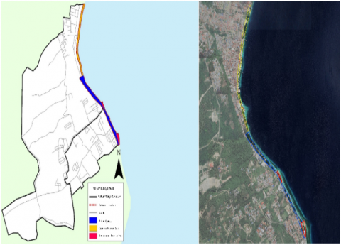
The research location was set in public spaces along the waterfront in Maahas and Tombang Permai villages, South Luwuk District, Banggai Regency, Central Sulawesi Province. The location was chosen based on the designation of Banggai Regency as a strategic area and its physical characteristics as a coastal public space that represents the identity of the Luwuk Urban Area as a waterfront city (Figure 1).
Figure 1. Research location
2.2 Population and sample
The population in this study consisted of users or visitors of public spaces along the coastal areas of Luwuk. Because the exact population size was unknown, the sample size was calculated using the Lemeshow formula [18], with a confidence level of 90 percent and a margin of error of 10 percent, resulting in 70 respondents considered representative of the population.
Respondents were selected using a purposive sampling approach, targeting active users of waterfront facilities who could provide meaningful evaluations of space conditions and user experience. To address potential time-related bias, a Time-Based Stratified Quota was applied. The sample was distributed across weekdays (Monday to Friday) and weekends (Saturday to Sunday), and further stratified by time of day: during weekdays, 15 respondents were surveyed in the morning (08:00–12:00) and 15 in the late afternoon (16:00–20:00); during weekends, 20 respondents were surveyed in the morning (08:00–11:00) and 20 in the late afternoon/evening (17:00–21:00). Respondents within each time slot were approached systematically on-site to ensure diverse and representative perspectives of public space usage and comfort.
2.3 Collect and analyze data
The data used consists of primary and secondary data. Primary data was obtained through field observations, questionnaires, and direct documentation at the research location, while secondary data was obtained indirectly from various sources such as books, journals, reports, and regional development planning documents [19]. The data collection and analysis techniques were tailored to the research objectives. Observation, documentation, and literature studies were used to describe the existing conditions of the area, while questionnaires were distributed to assess users' perceptions and experiences of placemaking aspects.
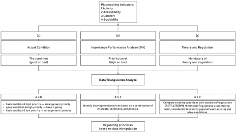
Data analysis was conducted descriptively to describe the condition of public spaces and the characteristics of the area, and the Importance Performance Analysis (IPA) method was used to evaluate the level of importance and performance of each aspect of placemaking [20]. The results of the two primary analyses (Actual Condition and IPA) were then triangulated and combined with an analysis of normative regulations to formulate guidelines for the functional and sustainable arrangement of waterfront public spaces. The Data Triangulation Analysis served as a synthesis mechanism that can be seen in Figure 2, systematically integrating findings from three streams: (a) Actual Condition, (b) Importance-Performance Analysis (IPA), and (c) Theory and Regulation. This rigorous process allowed us not only to establish development priority levels (by assessing a × b), but also to identify precise gaps between ideal and actual conditions (via a × c), ultimately resulting in Organizing Principles that are robustly justified by combining user interest, field conditions, and existing policy standards (b × c).
Figure 2. Triangulation flowchart
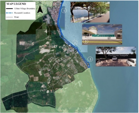
The research location is in the waterfront areas of Maahas and Tombang Permai villages, which are characterized as public spaces, culinary tourism destinations, and water recreation areas. Based on the Rencana Detail Tata Ruang (RDTR) or Detailed Spatial Plan or the Luwuk Urban Area, the research location is in SWP II.B.2 (Tombang Permai Village) and SWP II.B.4 (Maahas Village) with development guidelines as city parks, green belts, residential parks, and conservation of green open spaces that serve social and aesthetic functions for recreational, educational, and urban community service activities. In line with these guidelines, Banggai Regency Regulation No. 10 of 2012 concerning the 2012–2032 Spatial Plan for Banggai Regency stipulates a development policy for Luwuk as the regency capital, focusing on trade and services, offices, housing, industry, and tourism, complemented by a transportation infrastructure system and public service facilities through the arrangement of water areas to support the realization of the Luwuk Urban Area as a waterfront city.
3.1 Characteristics of waterfront public open spaces based on placemaking aspects
Four main aspects of placemaking namely activity and use, accessibility and connectivity, comfort and image, and sociability.
3.1.1 Activity and use
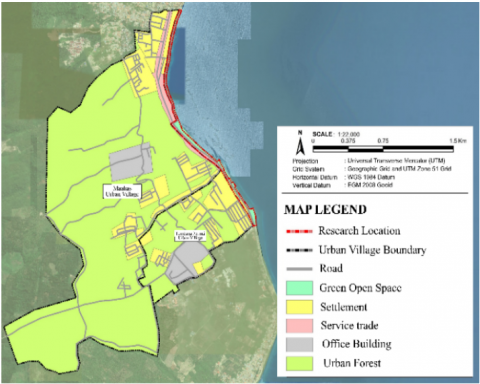
Gim [21] explained that community movement is influenced by activities outside the home, so that travel patterns and land use distribution are interrelated. Activities that take place in public waterfront spaces include active and passive activities, such as relaxing, enjoying culinary tourism, water recreation, fishing, and exercising. Functionally, the waterfront area at the research site consists of residential areas, offices, trade and services, public and social facilities, and urban green open spaces, can be seen in Figure 3.
Figure 3. Land use map
3.1.2 Accessibility and connectivity
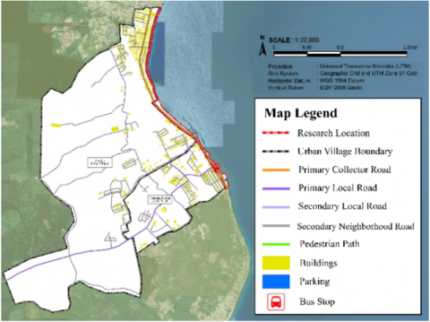
Accessibility and connectivity at the research site describe the ease with which users can reach the water's edge and enjoy the uninterrupted sea panorama, as well as its connectivity with the surrounding area. The location of the public space in the center of Luwuk City makes it easily accessible from various directions via the main road, namely Jalan Dr. Moh. Hatta, which is the primary collector road, can be seen in Figure 4. Geographically, this public space can be reached via collector roads and local roads that are well-paved and surrounded by city activity centers, thus supporting access by various modes of transportation. However, pedestrian access is still not optimal because pedestrian paths are not yet interconnected. In addition, visually, this public space does not yet have clear identifying elements, so its connectivity with the surrounding area is weak, and users often have difficulty recognizing its existence.
Figure 4. Map of the road in area
3.1.3 Comfort and image
Based on the principle of placemaking, comfort in public spaces plays an important role in shaping the image of a city. Public spaces that provide comfortable seating, lush vegetation, and clean and safe facilities can create an attractive environment for visitors. When users feel comfortable, they tend to spend more time in these spaces, thereby enhancing their individual experience and strengthening the image of the area as a friendly and lively space. This comfort is also supported by cleanliness, safety, and the availability of supporting facilities such as seating, garden lighting, rubbish bins, toilets, street lighting, vegetation, street vendors, information boards, landmarks, embankments, and bus stops. However, the condition of the facilities that can be seen in Figure 5, which are still simple and do not meet standards, indicates the need for further development and management so that public spaces can function optimally, provide comfort, and strengthen the identity of the area for its users.
Figure 5. Map of facilities
3.1.4 Sociability
In accordance with the principles of placemaking, public spaces should ideally be accessible and enjoyable for all groups. This is in line with the findings of Mccormack et al. [15], which emphasize the importance of considering socio-demographic characteristics in planning and management to improve social connectedness. Based on the survey results, public space users consisted of 41 men and 29 women, with a majority of 35 respondents being late teenagers, followed by 23 early adults and 12 late adults. Based on occupation, users consisted of students (23), entrepreneurs (21), private employees (20), housewives (14), and civil servants (2). Most visitors came with friends (54 respondents), in pairs (12), and only a small number came alone (4). The purpose of the visit was dominated by recreational activities (31 respondents) and relaxation (29), while the rest were culinary tours (6) and sports (4).
3.2 Evaluation of waterfront public open spaces
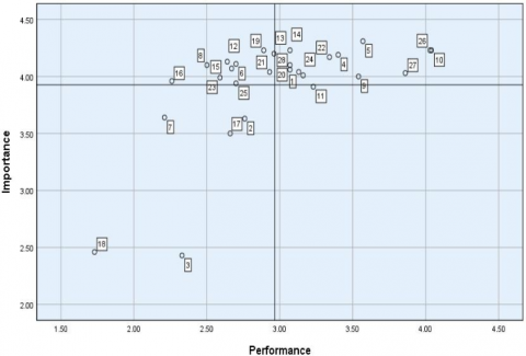
The level of suitability of public spaces in terms of performance and overall importance can be seen in Table 1, which displays the results of respondents' assessments of 28 characteristic indicators for each aspect of placemaking. In general, there are no variables with a Suitability Level (TKi) value above 100%, which means that the quality of public spaces has not yet reached the good category. All variables show a TKi value below 100%, indicating the need for improvement to meet ideal public space standards. After obtaining the suitability values for each indicator, they were mapped onto a Cartesian diagram to determine the indicators that are the top priorities in public space planning. Figure 6 shows the Cartesian diagram resulting from the Importance Performance Analysis (IPA).
Overall, the results of the Importance Performance Analysis (IPA) show that indicators in the public sphere are divided into four quadrants of suitability. However, the main focus of this study is on quadrants I and III, which include indicators with low performance and high importance (quadrant I), as well as indicators with low performance but considered less important by users (quadrant III). The indicators included in quadrant I are indicators 6, 8, 12, 13, 15, 16, 19, 21, 23, and 25, while the indicators in quadrant III are indicators 2, 3, 7, 17, and 18. These two groups of indicators form the basis for formulating priorities for public space planning, as they reflect aspects that require quality improvement so that waterfront public spaces can function optimally in accordance with the principles of placemaking.
Figure 6. Importance Performance Analysis (IPA) quadrant
Table 1. Analysis of the suitability level of placemaking aspects
|
No. |
Indicator |
Performance (Xi) |
Importance (Yi) |
TKi (%) |
|
Activities and Usage |
||||
|
1 |
Relaxing |
219 |
283 |
77.39 |
|
2 |
Exercising |
193 |
254 |
75.98 |
|
3 |
Fishing |
163 |
170 |
95.88 |
|
4 |
Culinary tourism |
238 |
293 |
81.23 |
|
5 |
Recreational tourism |
250 |
302 |
82.78 |
|
Accessibility and Connectivity |
||||
|
6 |
Pedestrian usability |
189 |
288 |
65.63 |
|
7 |
Availability of special needs accessibility |
155 |
255 |
60.78 |
|
8 |
Parking availability |
175 |
287 |
60.98 |
|
9 |
Accessible by public transportation |
248 |
280 |
88.57 |
|
10 |
Accessible by foot |
283 |
296 |
95.61 |
|
11 |
Accessible by private vehicle |
226 |
274 |
82.48 |
|
12 |
Physical and visual connectivity between public spaces |
185 |
289 |
64.01 |
|
Comfort and Image |
||||
|
13 |
Availability of lighting |
207 |
294 |
70.41 |
|
14 |
Availability of seating |
215 |
296 |
72.64 |
|
15 |
Availability of trash bins |
187 |
285 |
65.61 |
|
16 |
Availability of toilets |
158 |
277 |
57.04 |
|
17 |
Condition of vegetation |
186 |
245 |
75.92 |
|
18 |
Availability of vendor facilities or street vendors |
121 |
172 |
70.35 |
|
19 |
Availability of bus stops |
202 |
296 |
68.24 |
|
20 |
Cleanliness of public spaces |
215 |
287 |
74.91 |
|
21 |
Condition of pavement in public spaces |
205 |
283 |
72.44 |
|
22 |
Availability of information boards or road signs |
234 |
292 |
80.14 |
|
23 |
Existence of landmarks |
181 |
279 |
64.87 |
|
24 |
Safety from crime |
221 |
281 |
78.65 |
|
25 |
Safety from natural disasters (sea level rise or sea waves and abrasion) |
189 |
276 |
68.48 |
|
Sociability |
||||
|
26 |
Space can be used as a place for people to communicate with friends |
282 |
296 |
95.27 |
|
27 |
Space can be used as a place for people to communicate with new acquaintances |
270 |
282 |
95.74 |
|
28 |
Space can be used as a venue for festivals or social events |
215 |
284 |
75.70 |
3.3 Data triangulation
Triangulation was applied by combining data on public space characteristics, user evaluations, and literature sources such as standards, theories, and regulations to produce planning principles for waterfront public spaces. The formulation of planning criteria for public spaces in Maahas and Tombang Permai sub-districts is outlined below.
3.3.1 Activity and use
Observations of the actual conditions indicate that public spaces support a variety of activities, including jogging, football, fishing, relaxation, and culinary tourism. However, the integrity of these spaces is compromised: footpaths are frequently damaged and obstructed by community boats, while several culinary establishments encroach upon the waterfront, necessitating compliance with coastal boundary regulations. IPA analysis shows that sports and fishing activities have low performance but high user importance, making them priorities for immediate intervention. In contrast, relaxation and recreational activities perform well and should be maintained. Regulatory review confirms that the Maahas and Tombang Permai areas are designated as city parks and green belts, specifically intended to support social, recreational, and sports activities, with green open space policies emphasizing the need for adequate sports and recreational facilities.
Triangulation of these findings highlights a critical gap: although regulations and user priorities emphasize enhanced sports and recreational facilities, the current physical conditions undermine their implementation. Damaged footpaths and commercial encroachment hinder the waterfront’s function as a sustainable area for sports and recreation. Therefore, planning guidelines should prioritize the restoration and enhancement of core infrastructure, focusing on sports and fishing as priority activities. Aligning each spatial segment with its potential use will ensure compliance with Green Open Space regulations and zoning requirements, while strengthening the waterfront’s role as a functional and accessible public space.
3.3.2 Accessibility and connectivity
Public spaces along the Luwuk waterfront accommodate various activities such as jogging, playing football, fishing, relaxing, and culinary tourism. The condition of the pedestrian paths is still ineffective because some points are not connected, there are illegally parked vehicles, and there are no directional elements, making it difficult for new users to access. In addition, facilities for people with special needs are not yet available, while parking spaces are limited and connectivity between public spaces is still low. The IPA analysis shows that pedestrian paths, accessibility for people with special needs, and parking spaces are included in quadrant I as the main priority indicators for planning, while public transport and private vehicle accessibility are included in quadrants II and IV, which are already good and need to be maintained. Based on RDTR as spatial plan policies and placemaking principles, public spaces should be easily accessible, visible, connected, and accessible to all groups, as well as integrating visual, structural, and collective connection systems.
Triangulation of these findings highlights a critical gap: while regulations and user priorities stress the importance of accessible, connected, and inclusive public spaces, current conditions undermine these objectives. Disconnected and obstructed pedestrian paths, insufficient parking, and a lack of facilities for special needs users impede the effective use of the waterfront. Therefore, planning guidelines should prioritize the development and improvement of core accessibility infrastructure, focusing on pedestrian paths, inclusive access, and parking that meets standards. By utilizing public spaces and surrounding areas as an integrated connecting system with visual, structural, and collective approaches, the waterfront can achieve functional connectivity, compliance with spatial regulations, and enhanced accessibility for all user groups.
3.3.3 Comfort and image
Public spaces along the Luwuk waterfront accommodate various social and economic activities, but the supporting facilities are still uncomfortable and unsafe. Facilities such as lighting, rubbish bins, toilets, bus stops, paved areas, and vegetation do not meet standards, while vendor stalls and street vendors are still simple, and some sell on pedestrian walkways, reducing comfort and movement efficiency. The results of the IPA analysis show that the indicators of availability of lighting, rubbish bins, toilets, bus stops, paved areas, safety from natural disasters, and the existence of landmarks are in quadrant I, making them a top priority for improvement. The indicators for vegetation and street vendor facilities are in quadrant III, meaning that the conditions are not good, but their importance is low, so they need to be considered for improvement. Conversely, the availability of seating, cleanliness, information boards, and security from crime are in quadrant II and are already in good condition, so they need to be maintained. Based on the RDTR as spatial plan policy and placemaking concept, comfortable public spaces with identity enhance the quality of the user experience, while supporting facilities for pedestrian paths must be completed in accordance with standards.
Triangulation of these findings highlights a critical gap between user priorities, regulatory standards, and current conditions along the Luwuk waterfront. While regulations and placemaking principles emphasize the need for comfortable, safe, and identity-rich public spaces, many supporting facilities, such as lighting, rubbish bins, toilets, bus stops, paved areas, and disaster mitigation measures, remain inadequate or unsafe. Vendor stalls and street vendors occupying pedestrian paths further reduce comfort and movement efficiency. Therefore, planning guidelines should prioritize the improvement of these core facilities, while also enhancing the presence of landmarks to strengthen the waterfront’s identity. Addressing both functional and symbolic elements will ensure that public spaces are safe, accessible, and visually distinctive, aligning physical arrangements with user needs, regulatory requirements, and the broader goal of creating a high-quality waterfront experience.
3.3.4 Sociability
Public spaces along the Luwuk waterfront serve as places of social interaction for users from various communities and backgrounds. Users utilize public spaces to communicate with friends, meet new people, and participate in festivals or social activities, demonstrating that the sociability aspect of public spaces is functioning well. The IPA analysis shows that the sociability indicator falls within quadrant II, meaning that its level of importance and performance is high and therefore needs to be maintained. Based on placemaking and RDTR as spatial plan policies, quality public spaces must ensure benefits for social activities that are healthy, safe, comfortable, interactive, educational, recreational, and participatory.
Triangulation of these findings indicates that while the sociability of public spaces along the Luwuk waterfront is currently functioning well, ongoing planning efforts must ensure its sustainability. High performance and user importance suggest that social interaction should remain a core focus in the design and management of these areas. Therefore, planning guidelines should prioritize the maintenance and enhancement of activities, accessibility, and comfort to support interactions among diverse user groups. By fostering inclusive and engaging environments, public spaces can continue to facilitate healthy, safe, and participatory social activities, aligning with both placemaking principles and RDTR as spatial policies.
Table 2 presents the principles of arrangement formulated based on the triangulation of data for each aspect of placemaking.
Table 2. Organizing principles based on data triangulation
|
Placemaking Aspect |
Organizing Principles |
|
Activity and Use |
1. The utilization of each space segment is tailored to the potential activities available. 2. The layout focuses on priority aspects, namely sports and fishing activities. |
|
Accessibility and Connectivity |
1. Utilizing public spaces and surrounding areas as a connecting system with visual, structural, and collective approaches. 2. The layout focuses on pedestrian paths, accessibility for people with special needs, and parking spaces that meet standards. |
|
Comfort and Image |
1. The arrangement focuses on priority facilities, including lighting, rubbish bins, toilets, vegetation, street vendor stalls, bus stops, pavement, and disaster mitigation. 2. Strengthening the character of public spaces along the waterfront by enhancing the existence of landmarks as the identity of the waterfront city area. |
|
Sociability |
Maintaining the sociability of public spaces by developing activities, accessibility, and comfort so that these spaces continue to support social interaction among various groups. |
3.4 Guidelines for the organizing of waterfront public open spaces
The organizing guidelines are based on the formulation of arrangement principles, which are the result of triangulation analysis with reference to the characteristics of public spaces, the results of public space evaluations, and theories or regulations related to waterfront public spaces.
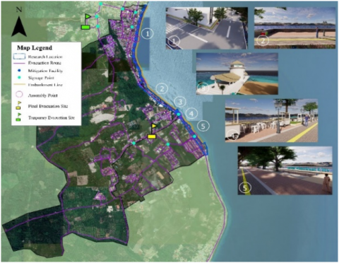
1. Creation of waterfront public open space segments along the waterfront, consisting of public spaces, culinary tourism, and recreation, as shown in Figure 7. These segments are designed to support diverse user activities and to provide a clear spatial structure for visitors.
Figure 7. Segments plan of waterfront public open space
2. Based on existing facilities that do not yet support activities, it is necessary to focus on prioritizing activities such as jogging, playing football, and fishing. Figure 8 shows a mapping of the activity and usage aspects. Ensuring that these activities are well accommodated will enhance user satisfaction and encourage repeated use of the waterfront.
Figure 8. Mapping the arrangement of activities and use
3. Utilization of the potential of public spaces and surrounding areas as a connecting system with a visual, structural, and collective linkage approach (accessibility and connectivity aspects). Figure 9 illustrates the application of the linkage system. This approach strengthens the cohesion of the waterfront by improving movement, orientation, and visual continuity for all users.
Figure 9. Illustration of linkage system
Figure 10. Mapping the arrangement of accessibility and connectivity
4. The layout focuses on priority aspects, namely pedestrian paths, availability of special needs accessibility, and availability of parking spaces (accessibility and connectivity aspects). Figure 10 shows a mapping of the accessibility and connectivity aspects of the layout. Enhancing these elements ensures inclusivity and smooth circulation, particularly for new visitors and people with mobility limitations.
5. The arrangement strategies to improve the Comfort and Image of the public spaces focus on enhancing priority facilities and establishing environmental resilience. Key functional improvements prioritize facilities identified through IPA, including lighting, rubbish bins, toilets, vegetation, street vendors, bus stops, and pavement quality. At the same time, given the waterfront’s vulnerability to coastal hazards such as high waves and abrasion, structural and non-structural mitigation measures are integrated alongside Low-Impact Development (LID) principles. Structural measures include maintaining existing seawalls and providing multi-functional, earthquake-resistant evacuation buildings. Non-structural measures involve clear evacuation routes and early warning systems. LID strategies, such as permeable pavements and enhanced vegetation buffers, help reduce surface runoff, flooding, and erosion caused by coastal hazards. This holistic approach ensures that the waterfront remains comfortable, safe, and ecologically sustainable while accommodating diverse user needs. Arrangement of comfort and image can be seen in Figure 11.
6. Utilization of the characteristics of public waterfront spaces by enhancing the existence of landmarks as the identity of waterfront cities through the application of city image elements (comfort and image aspects). Figure 12 shows a mapping of the application of city image elements. Landmarks and city image elements provide visual cues that reinforce the waterfront’s identity and support placemaking objectives.
Figure 11. Mapping the arrangement of comfort and image
Figure 12. Mapping the application image of the city
The results of the analysis show that waterfront public spaces in Luwuk have a variety of activities that take advantage of the characteristics of the coastal area. Its location in the center of the urban area makes it easily accessible from various directions, but connectivity between public spaces is still low. In addition, the condition of public space facilities is still simple and does not meet standards, so efforts are needed to develop facilities and infrastructure to provide comfort and a positive image for users. Public spaces also play an important role as a forum for social interaction that is open to all members of the community.
The evaluation of the performance and level of importance of placemaking indicators shows four priority levels. Indicators such as the presence of pedestrians, availability of parking spaces, connectivity between public spaces, lighting, rubbish bins, toilets, bus stops, pavement conditions, landmarks, and safety from disasters are included in quadrant I, which is the top priority for development. Indicators that need to be maintained include leisure activities, culinary and recreational tourism, ease of access by public transport or on foot, availability of seating, cleanliness, information boards, security from crime, and the function of public spaces as places for community activities. Meanwhile, sports activities, fishing, vegetation conditions, accessibility for people with disabilities, and the presence of street vendors are included in low priority. Indicators that are considered excessive, namely ease of access by private vehicle, are in quadrant IV.
The results of the triangulation analysis produced several guidelines for the arrangement of public spaces along the waterfront. These guidelines include: (1) establishing three main zones, namely public space zones, culinary tourism zones, and recreational tourism zones, which are arranged according to their respective functions; (2) arranging pedestrian paths, improving accessibility for users with special needs, providing adequate parking spaces, and implementing a linkage system to strengthen the connection between public spaces and surrounding areas; and (3) the arrangement of street vendors, lighting, rubbish bins, toilets, vegetation, bus stops, and pavements, as well as the application of mitigation aspects and city image elements to strengthen the identity of the area as a waterfront city. In addition, improvements in the quality of activities, accessibility, and comfort need to be continuously made so that public spaces can become ideal places for social interaction.
There are still several shortcomings in the study, such as the lack of discussion on non-physical aspects, resulting in insufficient discussion on sustainability aspects. Therefore, it is hoped that future studies can focus more on examining these aspects.
The authors would like to express their sincere gratitude to the Faculty of Engineering, Hasanuddin University, for their support and the facilities provided during the research process (Grant Number 15299/UN4.7.2/PM.01.01/2025). We also extend our deep appreciation to the editor and anonymous reviewers for their thorough and constructive feedback, which greatly improved the quality of this study.
[1] Ragheb, A.A., EL-Ashmawy, R.A. (2020). Urban waterfront development for designing space in coastal cities. International Journal of Sustainable Development and Planning, 15(3): 345-352. https://doi.org/10.18280/ijsdp.150311
[2] Permana, A.S., Astuti, W., Er, E. (2017). Waterfront development concepts in Indonesia from the perspective of urban planning and environmental sustainability. Internasional Journal of Built Environment and Sustainability, 4(3): 146-155. https://doi.org/10.11113/ijbes.v4.n3.207
[3] Petrtýlová, R., Matej, J. (2022). Waterfront character areas as the key elements in building the city - river relationship. International Review for Spatial Planning and Sustainable Development, 10(2): 19-37. https://doi.org/10.14246/irspsd.10.2_19
[4] Wisha, U.J., Dhiauddin, R., Ondara, K., Gemilang, W.A., Rahmawan, G.A. (2022). Assessing urban development impacts in the Padang coastline city, West Sumatra Indonesia; Coastline changes and coastal vulnerability. Geoplanning: Journal of Geomatics and Planning, 9(2): 73-88. https://doi.org/10.14710/geoplanning.9.2.73-88
[5] Budiyono, D., Nurisjah, S., Adrianto, L. (2013). Landscape planning of coastal tourism area in Lalong Luwuk City, Central Sulawesi. Jurnal Lanskap Indonesia 5(2): 21-27. https://doi.org/10.29244/jli.2013.5.2.21-27
[6] Shirvani, H. (1985). The Urban Design Process. Lund Humphries Publishers Ltd.
[7] Ali, S.M., Mohamed, A.N., Sohafi, N.E. (2020). Towards a sustainable waterfront development “Case study of Port Said City”. International Journal of Environmental Science, 5: 104-115. https://www.iaras.org/iaras/filedownloads/ijes/2020/008-0011(2020).pdf.
[8] JDIH. (2012). Regional Regulation Number 10 of 2012 concerning the Spatial Plan of Banggai Regency. https://peraturan.bpk.go.id/Details/77298/perda-kab-banggai-kepulauan-no-12-tahun-2012.
[9] Aryanda, H.R., Hadi, T.S., Puspitasari, A.Y. (2020). The influence of public open space revitalization on public visit motivation at Taman Indonesia Kaya. Ph.D thesis, Universitas Islam Sultan Agung Semarang. https://repository.unissula.ac.id/id/eprint/18718.
[10] Aptareka, B., Darmawati, R. (2022). Placemaking of children's play space under an urban bridge in Kalibata, South Jakarta. Indonesian Architecture Seminar & Exhibition, 272-284. http://hdl.handle.net/123456789/43193.
[11] Rachmawati, R., Mahagarmitha, R.R., Adinda, A., Mattin, A., Prayoga, S.A. (2025). Placemaking in commercial corridor road space grand city Balikpapan. Jurnal Penelitian Teknik, 2(1): 17-24. https://journal.lp3ktk.com/index.php/jpt/article/view/108.
[12] Dash, S.P. (2023). “Creative placemaking”: A conceptual model fostering social cohesion in community spaces within residential environments. Creativity Studies, 16(2): 541-564. https://doi.org/10.3846/cs.2023.16497
[13] Project for Public Spaces. Placemaking: What if we built our cities around places? https://www.pps.org/product/placemaking-what-if-we-built-our-cities-around-places, accessed on Nov. 18, 2025.
[14] Hartanti, N.B., Prabowo, A.H., Fadhilah, A., Rosnarti, D. (2019). Public space as development control element in coastal settlements: Comparison of urban design guidelines concepts. International Journal of Scientific & Technology Research, 8(10): 3417-3423.
[15] Mccormack, G.R., Swanson, K., Rock, M., Burto, L. (2014). Physical activity patterns in urban neighbourhood parks: Insights from a multiple case study. BMC Public Health, 14(1): 962. http://doi.org/10.1186/1471-2458-14-962
[16] Wang., L., Lu, S. (2019). Quantitative study on perception of the public space’s morphological characteristics of urban existing residential neighborhoods in China based on psychophysics. In ISUF 2019 XXVI International Seminar on Urban Form: Cities as Assemblages, Nicosia, CYPRUS. http://cyprusconferences.org/isuf2019.
[17] Hamzehkolaee, B.B. (2023). Quantitative explanation and evaluation of the qualitative factors of public spaces using the space syntax method (Case study: Ferdows garden in Tehran). The Monthly Scientific Journal of Bagh-e Nazar, 20(125): 45-56. https://doi.org/10.22034/BAGH.2023.387019.5341
[18] Sari, F.R. (2021). Makassar city tourism development strategy as a support for increasing city branding. Ph.D thesis, Hasanuddin University. https://repository.unhas.ac.id/id/eprint/8880/.
[19] Ajayi, V.O. (2017). Primary sources of data and secondary sources of data. Benue State University, 1(1): 1-6. https://doi.org/10.13140/RG.2.2.12480.85765
[20] Ormanovic, S., Ciric, A., Talovic, M., Alic, H., Jeleskovic, E., Causevic, D. (2017). Importance-performance analysis: Different approaches. Acta kinesiologica, 11: 58-66.
[21] Gim T.T. (2018). Land use, travel utility and travel behaviour: An analysis from the perspective of the positive utility of travel. Papers in Regional Science, 97(1): 169-193. https://doi.org/10.1111/pirs.12239