Widhianthini*![]() | Herlina Tarigan
| Herlina Tarigan![]() | Ida Ayu Nyoman Saskara
| Ida Ayu Nyoman Saskara![]() | Putu Perdana Kusuma Wiguna
| Putu Perdana Kusuma Wiguna![]()
© 2025 The authors. This article is published by IIETA and is licensed under the CC BY 4.0 license (http://creativecommons.org/licenses/by/4.0/).
OPEN ACCESS
The massive conversion of agricultural land in Bali due to pressure from the tourism sector poses a serious threat to food security and the sustainability of the agricultural sector. This study aims to design a sustainable food security-based agricultural area planning model and formulate strategies for its achievement. The methods used include a Dynamic Systems approach with Powersim Studio 10 simulation and Interpretive Structural Modeling (ISM) using Exsimpro for strategy analysis. The study was conducted in 45 subaks in 8 regencies and 1 city in Bali, involving 450 farmers and relevant stakeholders. Simulation results indicate that the involvement of traditional Subak and Desa Pakraman institutions can slow down the rate of land conversion and stabilize irrigation water flow. Additionally, the identification of key strategies through ISM prioritizes short-term measures such as strengthening traditional institutions and protecting agricultural land, as well as medium- and long-term measures such as organic agriculture transformation and integrating food policies with tourism. This study suggests the development of an integrated agricultural area model incorporating agropolitan and agrotourism concepts, along with the application of a systemic and locally-based Tri Hita Karana approach to create a fair, resilient, and sustainable food system in Bali.
food security, subak, traditional village, dynamic system, agropolitan, agrotourism
One of the Indonesian provinces that still relies heavily on agriculture and tourism to support its economy is Bali. In 2025, the agricultural industry in Bali Province would account for 13.65% of the Bali Regional Domestic Product (PDRB). This figure is still lower than the contribution of the agricultural sector in 2024, which was 15 percent [1]. The role of subak is directly related to the agriculture sector's continuous contribution to the GRDP. According to Bali Province's Provincial Regulation No. 02/PD/DPRD/1972 on Subak, the Subak are a traditional customary law community that controls irrigation in rice fields and has social, agricultural, and religious traits.
Moreover, Subak Lestari is not only a traditional irrigation structure, but also a strategic institution for the preservation of agricultural land, local culture, and the environment. By strengthening institutions, improving farmers' welfare, and building partnerships, Subak Lestari can become a bulwark against massive land conversion in Bali [2].
Although the agricultural sector still contributes to Bali's Gross Domestic Product (GDP), the pressure of tourism development has eroded agricultural land, resulting in land use change.
The shrinking of rice fields has also led to the loss of various positive externalities that arise from rice cultivation, especially in irrigated fields. This phenomenon highlights the growing threat to Bali's natural resources posed by the expansion of tourism infrastructure and facilities. A decrease in food self-sufficiency and the marginalization of farmers are the inevitable outcomes [3].
Land conversion continues to occur in Bali. This situation is feared to pose a threat to food security as the population grows, thereby increasing food demand. Each year, between 700 and 1,000 hectares of Bali's rice fields are converted into residential areas, hotels, restaurants, or other buildings supporting the tourism industry and other sectors. The total area of rice fields in Bali is 71,890 hectares, accounting for 19.97% of Bali's agricultural land (359,694 hectares). Consequently, no Bali farmer has a substantial amount of land. The massive conversion of agricultural land in Bali is occurring in the regencies of Badung, Tabanan, and Gianyar. The consequences of this conversion include the loss of fertile agricultural land and the potential loss of rice production [1]. If this conversion continues without controlled, area-based planning, Bali faces the risk of losing its food self-sufficiency due to the shrinking rice field area. Bali is undergoing a transformation of rice fields into non-rice agricultural land and settlements. These changes were largely driven by the expansion of the tourism sector and the pressures of urban development [4].
Agricultural area planning is essential to address land conversion. This planning involves spatial planning and land management processes to determine the location, size, and function of agricultural land so that it can be used sustainably and support food security. In many subak areas in Bali, agricultural zones have been designated in spatial planning. However, due to rising land values, many farmers are selling their land for villas and hotels, despite existing agricultural zone plans. One of the eight regencies and one city in Bali Province, Tabanan Regency—known as Bali's rice granary—is beginning to be affected by land conversion due to insufficient control over the implementation of agricultural zone plans. Over the past five years, land conversion in Tabanan has reached 2,676.61 hectares. This land conversion has transformed the subak's agrarian structure from a collective to a private basis, weakened the traditional water distribution system, and shifted the paradigm of rice field cultivation to commercial land [5].
Based on these issues, the goal of this project is to develop a food security-based agricultural area planning design or model and methods for realizing it.
2.1 Data collection and location of the study sites
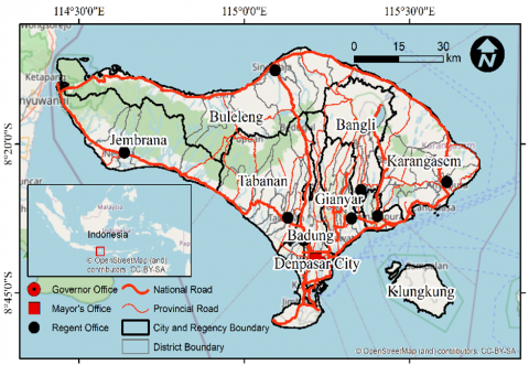
This study was conducted in Bali Province, Indonesia, covering eight districts and one city, each district and city consisting of five subaks, for a total of 45 subaks (Figure 1). Ten subak farmer members were selected from each of the 45 subaks, for a total of 450 people. Both primary and secondary data types were employed. Time series data from 2020 to 2024 make up the secondary data used, which was then simulated for the period from 2025 to 2040. The research was conducted from 2020 to 2024 in stages to identify the needs of farmers so that the variables in the sustainable food security-based agricultural area planning model and the stakeholders related to the strategy for achieving it could be determined. Informants or experts were sourced from the Agriculture Department, Tourism Department, Public Works Department (Irrigation Division), Regional Development Planning Agency and traditional villages overseeing subak irrigation systems.
Figure 1. Research location
2.2 Data analysis
There are two methods used in this study. To answer the first objective, namely the agricultural area planning model based on food security uses a dynamic system model with Powersim 10 software, while the second objective, which is decision-making related to the model achievement strategy, uses Interpretive Structural Modeling (ISM) analysis with Eksimpro software. These two analyses serve to integrate the agricultural and tourism sectors because both sectors contribute significantly to the province of Bali.
2.2.1 Dynamic systems
An efficient operating system is the final result of the systems approach, a problem-solving technique that starts with the identification and analysis of demands. Planning and management approaches, a multidisciplinary and structured approach, the capacity for non-quantitative thought, the use of mathematical models, simulation and optimization techniques, and computer application are some of the components of this systems approach [6].
Eriyatno [6] explains that in identifying a system, a black box must be created. The creation of the black box must be preceded by various types of information, namely: input variables, output variables, and parameters that limit the system structure.
The optimization model will be simulated using the Powersim Studio 10 programming language. Muhammadi and Soesilo [7] explained that this program is software for flowchart-based modeling. An interpretive programming language called Powersim Studio 10 uses a multi-level hierarchical environment method for both building and interacting with models.
An example of a dynamic system is one that exhibits interdependent relationships and evolves over time. Accordingly, a dynamic system is a linked feedback structure that strives for equilibrium. Based on the survey results, the elements that influence and are influenced have been identified at this point.
1) Model constraints
This research employs physical, economic, social, and institutional subsystems. The physical subsystem comprises land and water. The land subsystem encompasses the rice field area, accessibility of roads to rice fields, the size of residential land, the extent of green open space (GOS), the size of sacred areas, the area occupied by other buildings, and the proportion of built-up land. The water subsystem includes the flow of water from rivers and dams overseen by the Public Works Department (Irrigation Division) as well as the quantity of water used by the local community. The economic subsystem encompasses GDP, government support for villages, land leasing, Village Credit Institutions, tourist influx, educational resources, and community earnings. The social and institutional subsystem encompasses the population, labor force, workforce in agriculture and tourism, local institutional framework of subak and traditional villages, unemployment figures, poverty levels among residents, and the efficiency of subak and traditional villages.
2) Model Validation
Sterman [8] stated that validation in dynamic system modeling can occur through various methods, such as conducting direct structural tests without executing the model, performing structure-oriented behavior tests by operating the model, and making quantitative comparisons of behavior patterns between the model and the actual system. The validation techniques applied in this research are AME (Absolute Mean Error) and AVE (Absolute Variation Error). AME represents the difference between the average of the simulation results and the real value. AVE represents the difference between the simulation variance and the actual variance. The permissible deviation thresholds are AME under 10 percent and AVE over 10 percent.
AME = [(Si - Ai) / Ai]
Si = Si N, where S = simulation value
Ai = Ai N, where A = actual value
N = observation time interval
AVE = [(Ss - Sa) / Sa]
Ss = [(Si - Si)2 N] = simulation value deviation
Sa = [(Ai - Ai)2 N] = actual value deviation
N = observation time interval
2.2.2 Interpretive Structural Modeling (ISM)
Interpretative Structural Modelling (ISM) techniques, with the help of Exsimpro Software (https://exsimpro.com/software/), are used to formulate alternative policies for the future. ISM is a collective learning method where structural models are created to represent the intricacies of a system through thoughtfully crafted patterns utilizing visuals and text. ISM is one of the system modeling techniques used to address the challenging habits of long-term planning, which often directly apply operational research techniques and/or descriptive statistical applications [6]. The output from ISM can simplify problem management as it can be visualized through problem maps and hierarchical problem structures. ISM is an analytical tool and decision support tool that facilitates a comprehensive understanding of complex situations by linking and organizing ideas into a visual map [9].
ISM analysis entails interpreting a complete object or system depiction using operational research methods and/or descriptive statistical techniques. The ISM method consists of various steps, specifically [10]:
ISM model validation is iterative and based on expert interpretation. Although it does not always use statistics as in quantitative models, ISM validation still emphasizes logical consistency, expert involvement, and the practical suitability of the model being constructed [11].
3.1 Food security-based agricultural area planning model
In modeling using dynamic systems, a black box is first created. The purpose of creating a black box in dynamic system modeling is to simplify the complexity of the system and focus attention on inputs, outputs, and cause-and-effect relationships without having to know or model all the internal details of the system.
The black box that serves as a controlling factor in realizing a food security-based agricultural area planning model consists of government regulations, regional regulations, Provincial and District Spatial Plans (RTRWP & RTRWK), and customary laws (Awig-awig). Uncontrolled inputs include climate and inflation. Controlled inputs consist of Subak and Desa Pakraman infrastructure and facilities. Subak and Desa Pakraman. In this dynamic system, Subak and Desa Pakraman are included as influential variables in preventing land use conversion, given that rice fields in Bali are part of the Subak institution and Subak is part of Desa Pakramans (Figure 2).
Figure 2. Black box
Desa Pakramans are a form of customary law community in Bali that have the autonomy to regulate and manage their own affairs based on Balinese customary law, traditions, and culture. Desa Pakramans are a replacement for the term Desa Adat (customary village), which was previously commonly used. This term is used officially in Bali Provincial Regulation No. 3 of 2001 concerning Desa Pakraman Regulations [12-14].
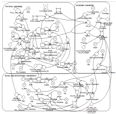
After the black box, the next step is to create an SFD (Stock Flow Diagram). The black box is the starting point for understanding the system, while the SFD is the next stage for dismantling, describing, and simulating the internal structure of the system dynamically.
Figure 3 shows that controlled inputs, namely Subak and Desa Pakraman infrastructure and facility support, play a very important role in Bali because both are socio-ecological institutions that play a direct role in preserving Bali's traditional agricultural system. Subak infrastructure consists of irrigation channels (temuku, telabah, petirtan), water distribution structures, and well-organized rice fields, designed to support collective rice farming. Facilities such as subak halls, warehouses, rice barns, and soil processing tools play a role in sustaining agricultural activities. Desa Pakramans (traditional villages) have the social and moral power to regulate and protect communal land. The combination of physical structures (infrastructure) and social structures (customary and spiritual rules) creates a socio-cultural control mechanism that can resist property market pressures, resist residential and tourism land expansion, and preserve Bali's agriculture-based cultural heritage. Major food commodities such as rice and corn are predominantly cultivated in wet rice fields, as the availability of irrigation and the fertility of volcanic soil in Bali support high productivity. In this dynamic system model, this simulates rice fields and water flow (Figure 3).
Figure 3. Stock flow diagram
Validation values for several variables in the physical, economic, social, and institutional subsystems are presented in the following Table 1.
Table 1. AME and AVE values
|
Variable |
AME |
AVE |
|
Rice Field |
0.006 |
4.356 |
|
Settlement |
0.039 |
0.380 |
|
Green Open Space |
0.098 |
4.337 |
|
Sacred Area |
0.022 |
3.790 |
|
Other Buildings |
0.036 |
0.878 |
|
GDP |
0.666 |
8.191 |
|
Population |
0.016 |
1.671 |
The deviation limit of all variables is less than 10 percent for AME and greater than 10 percent for AVE, so the model is valid and acceptable [15].
The model was simulated without including the Subak and Desa Pakraman variables (scenario I) and with including the Subak and Desa Pakraman variables (scenario II). The effectiveness of these two variables was assessed beforehand (Table 2).
Table 2. Simulation results for rice field area (Ha)
|
Year |
Scenario I (Without Subak and Pakraman Villages) |
Scenario II (With Subak and Pakraman Villages) |
|
2020 |
74723.20 |
74723.20 |
|
2021 |
74657.00 |
74657.00 |
|
2022 |
72347.00 |
72347.00 |
|
2023 |
71982.00 |
71982.00 |
|
2024 |
71890.00 |
71890.00 |
|
2025 |
70452.20 |
71818.11 |
|
2026 |
69043.16 |
71746.29 |
|
2027 |
67662.29 |
71674.55 |
|
2028 |
66309.05 |
71602.87 |
|
2029 |
64982.87 |
71531.27 |
|
2030 |
62383.55 |
71316.67 |
|
2031 |
61135.88 |
71245.36 |
|
2032 2033 |
59913.16 58725.86 |
71174.11 71163.14 |
|
2034 |
58714.90 |
71102.94 |
|
2035 |
57540.60 |
71031.84 |
|
2036 |
54663.57 |
70960.80 |
|
2037 |
53570.30 |
70889.84 |
|
2038 |
52498.89 |
70535.39 |
|
2039 |
51448.92 |
70464.86 |
|
2040 |
50419.94 |
69055.56 |
The simulation results show that the involvement of Subak and Desa Pakraman can slow down land conversion. In 2040, the estimated area of rice fields in Bali will be 69,055.56 hectares. If Subak and Desa Pakraman are not involved, the area of rice fields will be 50,419.94 hectares in 2040.
In terms of irrigation water discharge, there will be a significant change from 2020 to 2040 if Subak and Desa Pakraman are not involved. The amount of runoff water will also be very high. Runoff water is irrigation water that is discharged in excess of requirements and cannot be contained, causing it to flow out of the rice fields [16].
Based on Table 3, there has been a 75% reduction in water discharge over the past 20 years. Meanwhile, runoff water (water that flows out) will continue to increase until 2040 if the Subak and Desa Pakraman are not involved in irrigation management. Without the involvement of the Subak and Desa Pakraman, irrigation water management will become unsustainable, reducing agricultural productivity, accelerating environmental degradation, and eroding the cultural values that have been tested over hundreds of years in Bali.
Table 3. Irrigation water and runoff water debit (m3) without Subak and Desa Pakraman
|
Year |
Water Flow |
Running Water |
|
2020 |
71,156,655.55 |
123,040,733.00 |
|
2021 |
47,536,551.38 |
118,598,962.54 |
|
2022 |
32,759,090.66 |
123,224,322.08 |
|
2023 |
35,514,867.17 |
104,740,673.76 |
|
2024 |
20,317,418.36 |
118,356,961.35 |
|
2025 |
19,243,157.51 |
119,540,530.97 |
|
2026 |
18,993,978.85 |
120,735,936.28 |
|
2027 |
17,685,027.68 |
121,943,295.64 |
|
2028 |
17,902,100.32 |
123,162,728.60 |
|
2029 |
17,588,699.19 |
124,394,355.88 |
|
2030 |
17,343,906.11 |
125,638,299.44 |
|
2031 |
17,163,876.00 |
126,894,682.43 |
|
2032 |
17,042,874.21 |
128,163,629.26 |
|
2033 |
16,974,194.99 |
129,445,265.56 |
|
2034 |
16,950,879.06 |
130,739,718.21 |
|
2035 |
16,966,213.65 |
132,047,115.39 |
|
2036 |
17,014,039.17 |
133,367,586.55 |
|
2037 |
17,088,904.21 |
134,701,262.41 |
|
2038 |
17,186,113.37 |
136,048,275.03 |
|
2039 |
17,301,705.86 |
137,408,757.79 |
|
2040 |
17,432,394.98 |
138,782,845.36 |
Based on Table 4, it can be seen that the involvement of Subak and Desa Pakraman was able to limit the reduction in discharge. Although the discharge decreased from year to year, the decline was not as high as in Table 3. There was only a 56% change in irrigation water discharge from 2020 to 2040.
Table 4. Irrigation water and runoff water debit (m3) with the involvement of Subak and Desa Pakraman
|
Year |
Water Flow |
Running Water |
|
2020 |
71,156,655.55 |
123,040,733.00 |
|
2021 |
54,612,957.61 |
99,662,993.73 |
|
2022 |
50,529,172.14 |
103,549,850.49 |
|
2023 |
34,715,156.00 |
88,017,372.91 |
|
2024 |
33,289,566.79 |
99,459,631.39 |
|
2025 |
32,477,246.90 |
100,454,227.71 |
|
2026 |
31,175,186.25 |
101,458,769.98 |
|
2027 |
31,191,118.07 |
102,473,357.68 |
|
2028 |
30,726,052.59 |
103,498,091.26 |
|
2029 |
30,375,383.59 |
104,533,072.17 |
|
2030 |
30,130,583.77 |
105,578,402.89 |
|
2031 |
29,980,827.21 |
106,634,186.92 |
|
2032 |
29,914,342.20 |
107,700,528.79 |
|
2033 |
29,919,415.52 |
108,777,534.08 |
|
2034 |
29,955,312.68 |
109,795,342.93 |
|
2035 |
29,985,055.40 |
109,865,309.42 |
|
2036 |
30,101,368.20 |
110,963,962.51 |
|
2037 |
30,259,720.31 |
112,073,602.14 |
|
2038 |
30,452,753.98 |
113,194,338.16 |
|
2039 |
30,674,313.56 |
114,326,281.54 |
|
2040 |
31,183,651.30 |
116,624,239.80 |
Subak plays several roles in irrigation water management, including: ensuring fair water distribution among farmers through the Subak irrigation system, scheduling planting rotations and water flow (irrigation rotation) to maintain water flow and prevent shortages downstream, maintaining irrigation infrastructure (canals, rice fields, water gates) to prevent blockages, conducting rituals and ceremonies at the subak temple to seek blessings and smooth water flow, and collaborating with other subaks within the same river basin to ensure the sustainability of water sources [17-19].
The Pakraman Village is a traditional entity that plays a role in maintaining the social, spiritual, and traditional spatial order of the village, including agricultural land. The role of the Pakraman Village in maintaining water flow includes: protecting water source areas and customary forests (taksu) that serve as water catchment areas, establishing customary rules that prohibit the arbitrary conversion of subak land, thereby maintaining hydrological balance, supporting the sustainability of subak functions through traditional village decisions, including penalties for violators of water management rules, and preserving the sanctity and ecosystem of rivers as the primary source of irrigation water, for example by protecting springs from pollution. If Subak and traditional villages collaborate, they will produce a participatory and sustainable irrigation management system capable of maintaining stable water flow, both during the rainy and dry seasons, strengthening local food security, and preserving the sanctity and sustainability of the environment in both spiritual and ecological contexts.
3.2 Strategies for achieving sustainable agricultural areas based on food security
Based on the dynamic system model, several strategies were obtained from interviews with farmers, stakeholders, and experts, as follows:
These strategies are analyzed using ISM to determine which strategies are drivers and which are dependent. This is important so that policies address the root causes of problems rather than superficial symptoms. ISM also produces a hierarchical structure that explains which strategies should be implemented first as a foundation. The ISM results structure can be developed into a program implementation model in the form of a phased strategy roadmap, institutional intervention map, or program evaluation logical framework.
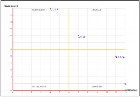
The results of the ISM analysis show that strategies E1 (strengthening Subak and Pakraman Village institutions), E2 (protecting agricultural land (rice fields) from conversion), E3 (vertical farming), and E5 (revitalizing participatory irrigation infrastructure) are in quadrant I, the independent quadrant. These strategies have high driver power and low dependency. They serve as drivers/motivators for the movement of other strategic objectives. Strategies E7 (empowering farmers' economic institutions (cooperatives, BUMDes, Village-Owned Enterprises)), E8 (diversification of commodities and integrated agricultural systems), and E11 (strengthening the regeneration of young farmers) are in the linkage quadrant, which has high driver power and dependence (Figure 4). This indicates that strategies in the independent and linkage quadrants are key criteria for determining the sustainability of Bali's agriculture sector based on food security. Meanwhile, strategies in the dependent quadrant cannot yet be considered key criteria because their driver power and dependence are still low. This condition is highly dependent on the success of strategies in the independent and linkage quadrants.
Figure 4. Diagram of the regional agricultural strategy based on sustainable food security in Bali
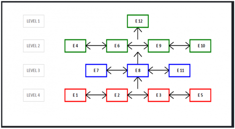
When viewed from a diagram structure, strategies E1, E2, E3, and E5 can be implemented in the short term. Strategies E7, E8, and E11 are implemented in the medium term, while strategies E4, E6, E9, and E10 are implemented in the long term, which will ultimately realize the 12th strategy, namely the integration of regional food policy with tourism (Figure 5).
Figure 5. Diagram of the structure of a sustainable food security-based agricultural strategy in Bali
At the short-term level, strengthening Subak institutions and Pakraman villages can be implemented by enhancing the role of Subak through regulatory support and village funds, integrating Subak into spatial planning systems and regional food policies.
The strategy for protecting agricultural land (rice fields) from land use conversion involves the establishment and monitoring of sustainable agricultural land (LP2B) and the implementation of fiscal incentives for farmers who continue to cultivate rice fields. The strategy for revitalizing participatory irrigation infrastructure involves improving tertiary and secondary irrigation through village funds or CSR and involving farmers and pekaseh in irrigation planning and maintenance. The fifth strategy is the empowerment of farmers' economic institutions (cooperatives, BUMDes) in the form of capital and management support for farmer cooperatives and food BUMDes and facilitating direct access to markets through e-commerce systems or local marketplaces.
In the medium term, the strategy is to adopt appropriate technology and mechanization through the provision of combine harvesters, fertilization drones, drip irrigation, and weather sensors, as well as training in agricultural digitization and land management applications. Strategy for strengthening local food reserve and distribution systems can be implemented through the establishment of village food storage facilities and village logistics systems, as well as through collaboration with Perum BULOG and local cooperatives. The strategy for diversifying commodities and integrated farming systems can be achieved through a combination of rice, horticulture, fisheries, and livestock (integrated farming) and mapping of local flagship commodities and climate-adaptive cropping patterns.
For the long term, there are five strategies. The first strategy involves improving the rice value chain through strengthening production upstream (farmers), such as: encouraging the use of high-quality seeds (such as Ciherang and Inpari 32), training in environmentally friendly agriculture and GAP (Good Agricultural Practices), providing subsidized fertilizers and biological pesticides, and optimizing water use through the repair and maintenance of irrigation channels; establishing farmer–RMU (Rice Milling Unit)–market partnerships; transparency and digitalization of the value chain through digital platforms for recording production, distribution, and finances; and multi-stakeholder and government involvement (synergy between the Agriculture, Public Works and Housing, Trade, and Tourism Departments). The second strategy is the transformation toward organic and environmentally friendly agriculture through training farmers in the use of organic fertilizers and plant-based pesticides, certification, and promotion of Bali organic rice to premium markets. The third strategy is the adoption of appropriate technology and mechanization through the provision of combine harvesters, fertilizer drones, drip irrigation, and weather sensors, as well as training in agricultural digitalization and land management applications. The fourth strategy is the strengthening of local food reserve and distribution systems through the establishment of village food storage facilities and village logistics systems, in collaboration with Perum BULOG and local cooperatives. Once all strategies are successfully implemented, a sustainable food security-based agricultural zone model will be realized through the integration of regional food policies with tourism by branding the agricultural zone as a sustainable agrotourism destination. Local farmers' products will be absorbed by hotels, restaurants, and souvenir markets.
The sustainability of an area needs to be planned early on so as not to kill off a sector. Bali's GDP contribution from the tourism sector needs to be integrated with the agricultural sector and other sectors. It is necessary to design an agropolitan concept that can be integrated with the agrotourism concept. Agropolitan is the development of an area that integrates the agricultural sector with other economic activities such as industry, services, and tourism. Agropolitan aims to create synergy between these sectors, which in turn can improve the welfare of rural communities [20]. The agropolitan concept has the potential to improve the quality of life in rural areas, create jobs, and reduce economic disparities between rural and urban areas [21, 22]. On the other hand, agrotourism through the creation of tourist villages can support this integration. Agrotourism is also a strategic tool to drive the rural economy through multiple benefits: agricultural productivity, tourism education, and environmental conservation [23]. Developing sustainable tourist villages will involve several aspects, such as local communities, improving the quality of tourist village products, and supporting local entrepreneurs. Institutional models for managing areas are needed to ensure the sustainability of long-term programs. Sustainable agricultural innovations, such as organic farming, agroforestry, or water-saving irrigation technology, as well as the expansion of digital farming and smart agriculture that can be applied by local farmers, are also necessary [24].
The integration of agropolitan and agrotourism based on sustainable food security is an integrated approach that combines the strengthening of agriculture-based regional economies (agropolitan) with the utilization of agricultural attractions as tourist destinations (agrotourism) to support sustainable food security in economic, social, and ecological terms [24-26] (Figure 6).
Figure 6. Integration of agropolitan with agrotourism
The concept of sustainable food systems (SFS) with a systemic approach (systems thinking) provides an analytical framework for understanding the complexity of food systems and designing integrated and systematic policies and interventions. Building a fair and environmentally friendly food system requires a systemic rather than an isolative approach, one that is integrative (involving all elements of the food system), transformational (rather than merely making small improvements), and based on strategic thinking through a food system analytical framework [27-29]. All these planning mechanisms must be monitored and evaluated regularly using success indicators, such as increased tourist numbers, farmer well-being, and improved regional economic value; and periodic evaluations of policies and programs implemented in Bali Province. With these mechanisms, agropolitan and agrotourism can complement each other, creating a strong agriculture-based economy and enhancing the sustainable appeal of tourist villages.
In research on sustainable food security-based agricultural area models in Bali, several important aspects can be added or explored in greater depth to make the results more comprehensive, contextual, and applicable, such as local genius values (Tri Hita Karana); spatial modeling and land use planning through spatial analysis (GIS) to map and identify potential land, critical land, and land use conversion patterns, integrated with the Regional Spatial Plan (RTRW) and agricultural zoning policies in Bali, to align with long-term regional planning; Green innovations and appropriate technologies through sustainable agricultural innovations, such as organic farming, water-saving irrigation technologies, and the expansion of digital farming and smart agriculture that can be applied by local farmers; recommending community-based adaptation strategies. Additionally, it is necessary to incorporate local food security indicators and develop an institutional management model for the area to ensure the sustainability of long-term programs.
This study designs a sustainable food security-based agricultural area planning model in Bali Province using a dynamic systems approach and ISM. The research findings indicate that the massive land conversion driven by tourism sector pressures threatens food security and the sustainability of Bali's agricultural sector.
This study designed a model for sustainable food security-based agricultural planning in Bali Province using a dynamic systems approach and ISM. The results showed that massive land conversion due to pressure from the tourism sector threatens food security and the sustainability of Bali's agricultural sector.
The dynamic system model proves that the involvement of Subak and Desa Pakraman can significantly slow down land conversion and maintain irrigation water discharge. Simulations show that in 2040, the area of rice fields that will be maintained will be higher if these two traditional institutions are involved.
Additionally, strategies such as strengthening traditional institutions, protecting agricultural land, revitalizing irrigation infrastructure, and empowering farmers' economic institutions are identified as key strategies that should be prioritized. These strategies are then organized into short-term, medium-term, and long-term priorities based on the results of the ISM analysis.
The study also emphasizes the importance of integrating agropolitan and agrotourism, as well as adopting a systemic approach in building a sustainable food system. For long-term sustainability, it is necessary to strengthen the institutional management of the area, utilize digital agricultural technology, and apply local principles such as Tri Hita Karana.
With this integrated approach, Bali's agricultural sector can maintain its existence as a pillar of food security without sacrificing the development of the tourism sector, which remains the mainstay of the regional economy.
This study has several limitations, including:
Limitations in the scope of the research location: the study only covers 45 subaks from 8 districts and 1 city in Bali Province, so it does not fully represent the full range of ecological, social, and economic conditions among the subaks spread across Bali.
Reliance on simulation data: the dynamic systems-based planning model relies on simulation data for the period 2025–2040, which is based on trends from 2020–2024. This makes the model highly dependent on future assumptions that could be altered by external conditions (e.g., disasters, economic crises, changes in national policy).
Does not integrate in-depth spatial analysis: the article suggests the use of GIS, but does not implement it concretely in spatial analysis of land use change, agricultural zoning, or identification of food vulnerability hotspots.
Not comprehensively measuring food security indicators: local food security indicators such as food sufficiency, access, price stability, and household consumption are not directly measured or used in model validation.
By acknowledging the limitations of this research, this study is expected to serve as a foundation or reference for policymakers to design programs related to strengthening sustainable agricultural areas while continuing to support tourism as a means of strengthening these areas through a more sophisticated analytical approach.
I would like to express my gratitude to the Ministry of Education, Science and Technology of the Republic of Indonesia, the Bali Provincial Agriculture and Tourism Office and other related agencies, as well as the Community Research and Development Institute of Udayana University, Bali.
[1] BPS Provinsi Bali. (2025). Bali Dalam Angka Tahun 2024. Badan Pusat Statistik Provinsi Bali. https://bali.bps.go.id/id/publication/2024/02/28/98fe74bb8f73f0d1c2cdda7a/provinsi-bali-dalam-angka-2024.html.
[2] Lestari, N.P.D.N., Ginting, A.H. (2021). Upaya penanggulangan alih fungsi lahan pertanian dengan pemberdayaan krama subak. Jurnal Pemerintahan Dan Keamanan Publik (JP Dan KP), 3(1): 1-12. https://doi.org/10.33701/jpkp.v3i1.2012
[3] Wahyundaria, D.A., Sunarta, I.N. (2021). Identifikasi dampak perkembangan pariwisata terhadap lingkungan di desa canggu, kecamatan kuta utara, kabupaten badung. Jurnal Destinasi Pariwisata, 9(1): 225-233.
[4] Widyastuty, A.A.S.A. (2021). Faktor yang mempengaruhi konversi lahan di desa kaba–Kaba tabanan bali. Seminar Nasional Hasil Riset Dan Pengabdian, 2: 275-280. https://snhrp.unipasby.ac.id/prosiding/index.php/snhrp/article/view/74.
[5] Ramadhan, S., Murti, R.P.W. (2024). Dinamika alih fungsi lahan sawah dan upaya perlindungan lahan pertanian pangan berkelanjutan di wilayah metropolitan sarbagita. Tunas Agraria, 7(3): 303-325. https://doi.org/10.31292/jta.v7i3.357
[6] Eriyatno, S. (2012). Ilmu sistem: meningkatkan mutu dan efektivitas manajemen. Bogor (ID): Guna Widya.
[7] Muhammadi, E.A., Soesilo, B. (2001). Analisis Sistem Dinamis: Lingkungan Hidup, Sosial, Ekonomi, Manajemen. Universitas Muhammadiyah Jakarta (UMJ) Press.
[8] Sterman J. (2000). Business Dynamics: System Thinking and Modeling for a Complex World. Singapore: The McGraw Hill Companies.
[9] Darmawan, D.P. (2017). Pengambilan Keputusan Terstruktur dengan Interpretative Structural Modelling. Denpasar: Penerbit Elmatera.
[10] Kumar, A., Singh, V. (2019). Overview of interpretive structural modeling. International Journal of Engineering Applied Sciences and Technology, 4(5): 536-540. http://doi.org/10.33564/ijeast.2019.v04i05.078
[11] Das, S.S., Kiron K.R., Pramod, V.R. (2024). Interpretive Structural Modeling (ISM): A literature review. International Journal of Creative Research Thoughts, 12(5): 863-868
[12] Kelly, D., Windia, W.P. (2019). Bali Mawacara: Is a quasi-common law system developing in balinese cus? Indonesia Law Review, 3: 296-308. http://doi.org/10.15742/ilrev.v9n3.587
[13] Eka Suadnyana, I.B. (2020). Desa pakraman sebagai lembaga adat dan lembaga agama bagi kehidupan masyarakat hindu di Bali. Jurnal Penerangan Agama Hindu, 18(1): 21-32. https://doi.org/10.33363/dd.v18i1.446
[14] Subanda, N.I., Latupeirissa, J.J.P., Prayana, I.K.R. (2023). Social pathology in the customary conflict of village-owned land druwe (A case study in Kubu Juntal Desa Pakraman, Karangasem Regency). Jurnal Sosial Budaya, 20(1): 50-60. http://doi.org/10.24014/sb.v20i1.21223
[15] Auping, W., d’Hont, F., Kubli, M., Slinger, J., Steinmann, P., van der Heijde, F., van Daalen, E., Pruyt, E., Thissen, W. (2024). The delft method for system dynamics. TU Delft OPEN Books. https://doi.org/10.59490/tb.97
[16] Wahjunie, E.D., Baskoro, D.P.T., Tarigan, S.D. (2021). Peran subak dalam mengurangi alih fungsi lahan di kelurahan penatih, kota denpasar. Jurnal Ilmu Pertanian Indonesia (JIPI), 26(2): 292-300. http://doi.org/10.18343/jipi.26.2.292
[17] Dipayana, K.R.K., Juliarthana, I.N.H. (2021). Peran subak dalam mengurangi alih fungsi lahan di kelurahan penatih, kota denpasar. Pranatacara Bhumandala: Jurnal Riset Planologi, 2(2): 102-113. https://doi.org/10.32795/pranatacara_bhumandala.v2i2.2228
[18] Ardana, P.D.H., Pamungkas, T.H., Agustin, E.A., Syamsunur, D. (2024). Delineation of irrigation network performance in Subak in South Denpasar district, Bali Province. Jurnal Presipitasi: Media Komunikasi dan Pengembangan Teknik Lingkungan, 21(3): 936-949. https://doi.org/10.14710/presipitasi.v21i3.936-949
[19] Winata, G.N.W., Rianse, U., Nalefo, L. (2024). Peran subak mertabayu dalam adaptasi perubahan iklim untuk meningkatkan produktivitas usahatani padi sawah di desa monapa kecamatan moeila kabupaten konawe selatan. Jurnal Ilmiah Inovasi dan Komunikasi Pembangunan Pertanian, 3(3): 189-200. http://doi.org/10.56189/jiikpp.v3i3.49023
[20] Miranti, A., Yuliani, E. (2023). Pengembangan Wilayah Agropolitan Untuk Menyelaraskan Kota dan Desa. Jurnal Kajian Ruang, 3(2): 224-240. http://doi.org/10.30659/jkr.v3i2.29506
[21] Wungo, G.L., Wungo, R., Susanti, R., Chafid, M., Salsabila, D.K., Napitupulu, C.B., Liring, T. (2022). Pengenalan Konsep Agropolitan Di Kecamatan Jumapolo Kabupaten Karanganyar. Jurnal Pasopati, 4(3): 157-161. https://doi.org/10.14710/pasopati.2022.14748
[22] Fadlil, M.A., Sumekar, W., Mardiningsih, D. (2020). Strategi pengembangan agrowisata berbasis bunga krisan (chrysanthemum morifolium R.) di taman bunga celosia, desa candi kecamatan bandungan kabupaten semarang. Jurnal Ekonomi Pertanian dan Agribisnis, 4(1): 39-50. http://doi.org/10.21776/ub.jepa.2020.004.01.4
[23] Widhianthini, W. (2017). A dynamic model for sustainable tourism village planning based on local institutions. Journal of Regional and City Planning, 28(1): 1-15. https://doi.org/10.5614/jrcp.2017.28.1.1
[24] Martadona, I., Purnamadewi, Y.L., Najib, M. (2014). Strategi pengembangan kawasan agropolitan berbasis tanaman pangan di kota padang (Agropolitan development strategy based on food crops in Padang city). TATALOKA, 16(4): 234-244. https://doi.org/10.14710/tataloka.16.4.234-244
[25] Tono, Ariani, M., Suryana, A. (2023). Indonesian food security performance: Lesson Learned from the assessment with global and national criteria. Analisis Kebijakan Pertanian, 21(1): 1-20. http://doi.org/10.21082/akp.v21n1.2023.1-20
[26] Mahendra, I.W.E., Parmithi, N.N. (2021). Optimization of agropolitan tourism village for ornamental plants based on the concept of Tri Hita Karana. Community Empowerment, 6(6): 1090-1095. https://doi.org/10.31603/ce.5128
[27] Faizi, M.D., Saridewi, T.R., Ilhami, W.T. (2025). Perencanaan lanskap bagi pengembangan agrowisata CV wanda strawberry di kabupaten bandung barat. Jurnal Agroekoteknologi dan Agribisnis, 8(2): 192-212. https://doi.org/10.51852/jaa.v8i2.543
[28] Kementerian Pertanian Republik Indonesia. (2018). Roadmap pertanian berkelanjutan 2019-2024. Jakarta: Pusat Data dan Sistem Informasi Pertanian. https://bpmsph.ditjenpkh.pertanian.go.id/storage/master/file/DXOdcCmc_RENSTRA-KEMENTAN-2020-2024-REVISI-2-26-Agt-2021.pdf.
[29] Food and Agriculture Organization of the United Nations. (2021). Sustainable food systems: Concept and framework. Rome: FAO. Hsuyana. https://www.fao.org/sustainable-food-value-chains/.