Rendi Prayuda*![]() | M. Irfan Rosyadi
| M. Irfan Rosyadi![]() | Rijalul Fikri
| Rijalul Fikri![]() | Muhammad Faisal Amrillah
| Muhammad Faisal Amrillah![]()
© 2025 The authors. This article is published by IIETA and is licensed under the CC BY 4.0 license (http://creativecommons.org/licenses/by/4.0/).
OPEN ACCESS
This study examines the integration of environmental sustainability and borderland development through the formulation of a sustainable tourism model for Rupat Island, Indonesia, a designated National Tourism Strategic Area situated near the maritime border with Malaysia. Rupat Island, located in the Indonesia-Malaysia border region, holds a strategic position as a National Tourism Strategic Area. Despite its ecological and cultural potential, the island faces significant challenges, including environmental degradation, fragmented governance, and limited community engagement. Drawing on field observations, stakeholder interviews, and policy analysis, this research identifies three critical pillars for a sustainable tourism framework: ecological conservation zoning, community-based tourism (CBT) empowerment, and institutional integration. The proposed model emphasizes participatory governance, ecological stewardship, and socio-economic inclusion, aligning local development objectives with national tourism priorities and regional borderland dynamics. Findings underscore the importance of multi-level coordination and adaptive policy frameworks to ensure that tourism in peripheral and border regions contributes meaningfully to long-term sustainability and territorial resilience. The study offers theoretical and practical insights into how tourism can function as a strategic tool for integrated development in ecologically sensitive and geopolitically significant border zones.
sustainable tourism, borderland development, environmental sustainability, community-based tourism, Rupat Island Indonesia
Borderland regions around the world often face a dual reality: they are rich in natural and cultural resources but remain economically underdeveloped and environmentally vulnerable. These peripheral areas frequently lack the infrastructure, investment, and policy attention found in central regions, leading to limited livelihood opportunities for local communities [1-3]. At the same time, many borderlands possess unique ecological landscapes and indigenous knowledge systems that, if sustainably managed, could serve as strong foundations for eco-tourism and inclusive development. Integrating environmental sustainability with borderland development presents a strategic approach to address ecological degradation while empowering marginalized populations. Guided by principles of sustainable development and place-based tourism planning, this article proposes a tourism model that balances conservation with socio-economic growth, offering a pathway for border regions to thrive without compromising their environmental integrity.
Tourism development in border regions represents a critical intersection between economic potential and environmental vulnerability. In Indonesia, several peripheral areas have been designated as National Tourism Strategic Areas to promote equitable development and regional growth through tourism [4]. Rupat Island in Riau Province, located near the Strait of Malacca, is one such area with rich natural beauty and cultural heritage. However, it faces typical borderland challenges, including ecological fragility, infrastructure gaps, and socioeconomic marginalization [5, 6].
A sustainable tourism model is urgently needed to balance ecological preservation, community welfare, and economic viability [7]. Without such integration, unregulated tourism risks worsening environmental degradation and spatial inequality [8, 9]. Tourism, while a major global economic driver, must be planned with care—supporting infrastructure, employment, human capital, and investment [10].
Indonesia, as an archipelagic nation with vast and diverse border regions, faces unique challenges and opportunities in aligning environmental sustainability with regional development. Many of these borderland areas, often located in ecologically sensitive zones, possess high tourism potential but remain marginalized in national development efforts. The tension between exploiting natural resources for economic growth and preserving environmental integrity has become a critical policy concern. In response, Indonesia’s national development framework and the Sustainable Tourism Development Strategy—has increasingly emphasized the importance of inclusive, green, and locally grounded tourism models. Drawing from theories of sustainable development and borderland governance, this article explores how tourism can serve as a strategic tool to simultaneously promote environmental conservation, strengthen local economies, and enhance the socio-political integration of border communities. By proposing a tourism model that is environmentally conscious and contextually adaptive, the article aims to offer insights for replicable practices across Indonesia’s diverse border regions.
As an archipelagic state, Indonesia possesses immense coastal tourism potential. Rupat Island, designated as a National Tourism Strategic Areas and known as the “Coastal Gate” in the Bengkalis Regency document plan, is strategically located near Malaysia and Singapore. This study proposes a tourism development model that integrates environmental sustainability and borderland development tailored to Rupat’s context. It explores how tourism can become a catalyst for inclusive, resilient growth in peripheral zones, offering insights for similar transboundary regions across Southeast Asia.
The urgency of addressing tourism development in border areas lies not only in economic aspirations but also in safeguarding vulnerable ecosystems and ensuring inclusive growth [11]. In Rupat Island, tourism potential remains underutilized due to limited accessibility, weak institutional coordination, and insufficient environmental safeguards. These conditions highlight the need for an integrated planning model that prioritizes ecological resilience while empowering local communities as key stakeholders in the tourism value chain.
Rupat Island, located on the outermost edge of Indonesia’s maritime boundary with Malaysia, holds strategic geopolitical, ecological, and socio-cultural significance. As part of Indonesia’s national border regions, it is prioritized in national development policies such as the National Medium-Term Development Plan and the Nawacita agenda, which emphasize the importance of developing peripheral regions to strengthen national sovereignty and reduce inequality. Despite this, Rupat remains underdeveloped, with fragile ecosystems, limited infrastructure, and a tourism sector that lacks sustainable planning. Theoretical perspectives from borderland development and sustainable tourism suggest that integrating ecological conservation with participatory economic strategies can create resilient local economies while safeguarding environmental integrity. In this light, Rupat Island offers a unique opportunity to implement a tourism model that is environmentally sustainable, community-based, and aligned with national goals for inclusive and regionally balanced development. This approach positions the island not merely as a remote border zone, but as a frontier for innovation in sustainable tourism and cross-border cooperation.
This study aims to propose a sustainable tourism development model tailored to the specific socio-ecological and geopolitical context of Rupat Island. By employing an interdisciplinary approach that draws upon environmental studies, tourism policy, and borderland development theories, the research seeks to answer the following questions: How can sustainable tourism serve as a catalyst for integrated borderland development in Indonesia? What institutional, ecological, and community-based mechanisms are essential to ensuring the resilience of such efforts?
This study draws on a multi-disciplinary framework that intersects environmental studies, borderland development, and sustainable tourism policy. Concepts such as community-based tourism, eco-tourism, and transboundary cooperation form the foundation of this approach. The research adopts a systems thinking lens to map the interdependencies between institutions, local actors, and environmental assets, emphasizing the need for adaptive governance and inclusive policy instruments [12, 13].
This study employs a qualitative approach to provide a comprehensive understanding of sustainable tourism and borderland development in Rupat Island. The descriptive research design is used to explore patterns, perceptions, and interrelations among stakeholders and institutional mechanisms relevant to the National Tourism Strategic Area in Rupat and its surrounding region.
Primary data were obtained from field observations, interviews, and surveys. Key informants were purposively selected based on their expertise, positional relevance, and direct involvement in tourism development—this includes officials from the Tourism Office, local government agencies, tourism associations, tourism entrepreneurs, and community leaders (Table 1). Secondary data were gathered from planning documents, regulatory frameworks, previous studies, and photographic records to contextualize findings.
Qualitative and quantitative data were integrated during the interpretation phase. Qualitative insights were used to explain or elaborate on statistical trends, while survey data validated themes emerging from interviews and observations. The analysis followed the model of a previous study [14], involving three steps: data reduction (focusing and organizing key information), data display (using narrative descriptions, matrices, and diagrams), and conclusion drawing/verification (identifying patterns and drawing inferences).
This triangulated methodology ensures analytical rigor, enhances the credibility of findings, and facilitates the development of a contextualized, evidence-based tourism development model for Rupat Island.
Table 1. Details of interviews conducted
|
Informants |
Criteria for Participation |
Type of Interview |
Number |
|
Tourism Office Officials |
Government staff involved in KSPN planning and tourism regulation |
Semi-structured |
5 |
|
Local Government Agencies |
Officials from Bappeda, environment, transportation, and infrastructure |
Semi-structured |
4 |
|
Tourism Entrepreneurs |
Owners/managers of homestays, travel agents, culinary and marine tourism |
Semi-structured |
6 |
|
Local Community Leaders |
Village heads, adat leaders, coastal community representatives |
In-depth |
5 |
|
Tourism Associations |
Representatives of regional/national tourism organizations |
Semi-structured |
3 |
|
Academic Experts |
Researchers with expertise in tourism, environment, and spatial planning |
Expert interview |
2 |
|
NGOs/CSOs |
Organizations engaged in environmental advocacy or community tourism |
In-depth |
2 |
|
Total |
27 |
||
This section presents the key findings of the study and discusses their implications for the development of a sustainable tourism model on Rupat Island. Drawing from field observations, interviews with local stakeholders, and policy analysis, the research reveals the complex interplay between environmental conservation efforts and the socio-economic dynamics of a borderland community. The discussion is organized around three central themes: the current state of natural resource management, the readiness and participation of local communities, and the institutional challenges in integrating environmental and development goals. By linking empirical findings with relevant theoretical frameworks, this section highlights both the opportunities and barriers in designing a tourism model that is environmentally sustainable, socially inclusive, and aligned with national borderland development strategies.
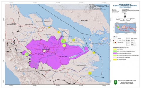
The development of Provincial Strategic Areas is the establishment of areas that are able to encourage economic growth, equitable development and pay attention to socio-cultural aspects and environmental preservation. The planned development of Riau Province's strategic areas are: (a) Strategic Area (Pekanbaru-Siak-Kampar-Pelalawan); (b) Panjang Strait Area and Its Surroundings; (c) Kuala Enok-Bird Island Area; (d) Dumai Industrial Estate; (e) Tenayan Industrial Estate; (f) Tanjung Buton Industrial Estate; (g) Buruk Bakul Industrial Estate; (h) Pelalawan Industrial Estate; (i) Kampar Industrial Estate; (j) Technopolitan Area in Pelalawan Regency; and (k) Rupat Island Development Area.
3.1 Current conditions of tourism and environmental assets in Rupat Island
Field observations and stakeholder interviews reveal that Rupat Island possesses considerable environmental assets, including white sandy beaches, mangrove forests, and a relatively unpolluted coastal ecosystem. However, these assets remain underutilized and face environmental pressures from illegal logging, unmanaged waste, and sand mining activities [6, 15]. The infrastructure to support sustainable tourism—such as eco-friendly accommodations, renewable energy integration, and regulated zoning—is limited or absent. Moreover, community participation in tourism development remains low due to limited capacity, access to capital, and institutional support [5].
The research findings indicate that Rupat Island possesses considerable potential for developing a sustainable tourism model, owing to its rich coastal ecosystems, cultural heritage, and strategic location along Indonesia’s maritime border. However, environmental degradation—such as mangrove deforestation, coastal erosion, and unregulated waste disposal—poses significant threats to long-term sustainability. Field interviews with local residents and stakeholders revealed a growing awareness of environmental issues, but limited capacity and institutional support hinder effective community-based conservation. Moreover, although tourism has begun to emerge as an alternative economic opportunity, it remains informal and fragmented, lacking integration into regional or national tourism plans [16, 17]. From a governance perspective, there is a disconnect between environmental protection policies and borderland development initiatives, leading to overlapping authorities and inconsistent implementation. This study argues that a viable tourism model for Rupat Island must be rooted in participatory planning, ecosystem-based management, and cross-sectoral coordination that aligns with Indonesia’s sustainable border development agenda. Strengthening local institutions, empowering community participation, and integrating ecological principles into spatial planning are essential to ensuring that tourism development supports both environmental integrity and socio-economic resilience.
This situation reflects a broader trend in peripheral tourism development, where environmental potential exists but institutional mechanisms for sustainability are weak [18]. Without strategic planning, Rupat Island risks falling into the pattern of extractive tourism development that prioritizes short-term economic gains over long-term ecological and community resilience. Figure 1 explains the map of the Riau Province of Indonesia, which borders directly with Malaysia and Singapore.
Figure 1. Strategic area map of Riau Province
3.2 Stakeholder perception and institutional challenges
Stakeholder interviews conducted with local government officials, tourism operators, NGOs, and community leaders indicate a shared recognition of the need for a sustainable tourism model. However, perceptions of sustainability vary across groups. Local authorities tend to associate sustainability with economic revenue and regional competitiveness, while community members emphasize the preservation of cultural and natural resources for future generations.
Institutional challenges persist in coordinating across administrative levels. The lack of clear regulatory frameworks, limited inter-agency cooperation, and insufficient budget allocation for environmental programs hamper the realization of integrated development [4]. Additionally, the borderland status of Rupat Island—adjacent to international shipping routes and under surveillance for maritime security—complicates land use planning and tourism governance [19].
The realization of Provincial Strategic Areas consists of: a). assessment of the potential and problems of development or management of the area; b). preparation of action programs for area management; c). preparation of detailed spatial plans for strategic areas; and d). development of facilities and infrastructure supporting strategic areas.
Based on the picture above, Rupat Island is geopolitically strategically located as one of the foremost islands on the Malacca Strait shipping lane (one of the four strategic chokepoints in Indonesia) so that it is worth developing into the western gate of the archipelago (Atlantic Gate), and is the veranda of one of the National Tourism Development Areas border areas towards the border with Malaysia in the Malacca Strait. In general, the land of Rupat Island is quite suitable for planting paddy rice, upland rice, corn, tomatoes and chilies, as well as for annual crops, namely oil palm and rubber. Meanwhile, 4,500 ha of land in the Morong Strait is available for fisheries development, especially snapper and shrimp.
Tourism areas as referred to in paragraph (1) include:
1) National Tourism Destination Area includes Pekanbaru, Rupat and surrounding areas;
2) National Tourism Strategic Areas include Rupat and its surroundings;
3) National Tourism Development Areas include Muara Takus - Kampar and surrounding areas, Pekanbaru City and surrounding areas, Rupat-Bengkalis and surrounding areas, Jemur Island-Rokan Hilir and surrounding areas, Siak Sri Indrapura and surrounding areas, Bukit Tiga Puluh-Indragiri Hulu-Indragiri Hilir and surrounding areas, Bono-Pelalawan and surrounding areas, Islamic Center-Rokan Hulu and surrounding areas, Solop Beach-Indragiri Hilir and surrounding areas, Puak Beach-Dumai and surrounding areas, Bokor-Tasik Nambus-Meranti Islands and surrounding areas, Guruh Gemurai Waterfall-Kuantan Singingi and surrounding areas; and
4) Tourism Development Areas include Provincial and Regency/City.
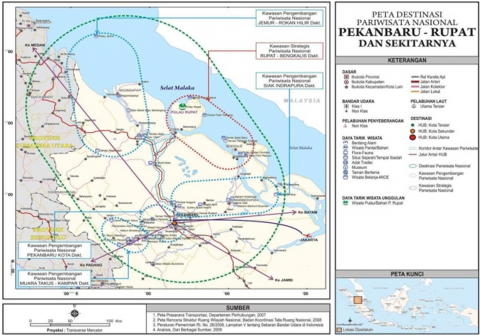
Figure 2 below explains the Rupat Island tourist map from Pekanbaru City as the capital of Riau Province, namely:
Figure 2. National tourism destination map Pekanbaru-Rupat around it
Government Regulation No. 50/2011 has also regulated national tourism regionalization consisting of national tourism destinations with provincial and/or cross-provincial coverage in which there are national tourism development areas, among which are National Tourism Strategic Areas. This Government Regulation also stipulates 50 DPNs, 222 KPPNs, 88 of which are National Tourism Strategic Areas. In Appendix II of Government Regulation No. 50/2011 on Ripparnas Year 2010-2025, in Riau Province there is one National Tourism Destination Area, namely National Tourism Destination Area Pekanbaru-Rupat and its surroundings. National Tourism Destination Area Pekanbaru-Rupat and its surroundings consist of one National Tourism Strategic Areas, namely National Tourism Strategic Areas Rupat-Bengkalis and its surroundings, and four National Tourism Development Areas namely National Tourism Development Areas Jemur-Rokan Hilir and its surroundings, National Tourism Development Areas Siak-Indrapura and its surroundings, National Tourism Development Areas Pekanbaru Kota and its surroundings, and National Tourism Development Areas Muara Takus- Kampar and its surroundings. In the Riau Province area, there is also one National Tourism Development Areas that is part of another National Tourism Development Areas where most of the National Tourism Development Areas locations are in other provinces, namely National Tourism Development Areas Bukit Tigapuluh-Rengat and its surroundings, which is located in the Jambi-Kerinci Seblat National Tourism Development Areas and its surroundings.
At the macro level, the system of activity centers in Rupat and North Rupat Sub-districts based on the Bengkalis Regency Spatial plans is to promote the Batu Panjang and Tanjung Medang areas as local activity centers, which are expected to be able to drive the development of economic activity centers and or settlement centers on Rupat Island supported by the tourism, agriculture, plantation, fisheries and trade sectors and linked to the accelerated development of the Mandiri Integrated City urban area. The activity center system formed in Rupat and North Rupat Sub-districts based on the macro activity center system is as follows:
First, the Central Development Area is located in the center of the sub-district government or the capital of the sub-district, namely Kelurahan Batu Panjang and Kelurahan Tanjung Medang.
Second, supporting Area, is an area that functionally has a function as a secondary service center for the surrounding population and as a supporter of the Central Development Area. The development of secondary centers in each supporting area serves as a buffer for the Central Development Area, and service efficiency at the sub-district scale. The distribution of secondary centers is also intended to support the harmonious development of development activities between the Central Development Area and supporting areas. The secondary centers that will be developed consist of three areas, namely: Pangkalan Nyirih Supporting Area in Rupat District, Tanjung Kapal Supporting Area in Rupat District and Teluk Lecah Supporting Area in Rupat District.
Third, Neighborhood Development Center. In addition to the main centers and sub-centers, several new service centers are proposed at the neighborhood scale that also function to connect the Central Development Area with other Supporting Areas, as well as connecting between Supporting Neighborhoods.
The transportation network system policy of Rupat and North Rupat Sub-districts is directed at developing a network system that integrates all regional activity centers of Bengkalis Regency and rural systems and provides services to as many settlements as possible. Based on this policy direction, it is translated into several development strategies, including: 1). Supporting the development of primary local roads (Rupat Island ring road); Primary local roads serving the island area will be developed with a ring road pattern and connected to the port system (Ro-Ro Tanjung Kapal and Tanjung Medang Port). This road will play a strategic role in encouraging the development of Tanjung Medang urban development and the development of tourism, agriculture, plantations and fisheries areas as well as encouraging the development of an Independent Integrated City area. Some sections of the Rupat ring road have already been built; 2). Support the development of Tanjung Medang Special Port as a Tourism Port; 3). Increase the number of Ro-Ro vessels serving Tanjung Kapal - Dumai; 4). Support the construction of an airport, planned to support the development of tourism activities. The airport is located on Rupat Island. The development of Rupat Airport is planned in an integrated manner to support the development of Tanjung Medang tourism area; 5). Supporting the development of the West - East transportation axis directed to connect the movement from Tanjung Medang in North Rupat District. This West-East axis includes movements from Tanjung Medang (North Rupat Sub-district) - Bengkalis Urban - Ketam Putih (Bengkalis Sub-district). Overall, the movement of the West-East axis is able to connect 2 large islands in Bengkalis Regency, namely Rupat Island and Bengkalis Island. Sea transportation from Rupat Island to Bengkalis Island is connected by a ferry crossing service.
3.3 Attractions analysis
Tourism Destinations are different geographical areas or areas in one or more administrative areas in which there are elements: tourist attractions, tourism facilities, accessibility, communities and tourists that are interrelated and complementary to the realization of tourism activities. Attractions that are not or have not been developed are potential resources and cannot be called tourist attractions, until there is a certain type of development. Objects and tourist attractions are the basis for tourism. Without an attraction in a certain area or place, tourism is difficult to develop.
Tourism Attraction is actually another word for tourist attraction, but according to Indonesian government regulations in 2009 the word tourist attraction is no longer relevant to mention a tourist destination, so the word “Tourism Attraction” is used.
A tourist attraction is anything that has uniqueness, beauty, and value in the form of diversity of natural, cultural, and man-made wealth that is the target or destination of tourist visits. Furthermore, tourist attractions are divided into three categories, namely natural tourist attractions, cultural tourist attractions, and man-made tourist attractions.
Natural tourist attraction is a tourist attraction in the form of diversity and uniqueness of the natural environment; cultural tourist attraction is a tourist attraction in the form of the results of copyright, taste and human spirit as cultural beings; and man-made tourist attraction is a special tourist attraction that is artificially created and other human activities outside the realm of natural tourism and cultural tourism. An area is said to have a tourist attraction if it has properties:
1) Uniqueness, which is rare or not found in other areas so that it becomes one of the characteristics of the tourist area.
2) The authenticity of nature and daily customs, where tourists can see customs and traditional clothes that are different from what they are used to.
3) Rarity, difficult to find in other regions/countries.
4) Growing enthusiasm and providing value for tourists.
The tourism potential in the National Tourism Destination Area Rupat area and its surroundings consists of nature, cultural and historical tourism, and special interest tourism. In addition, there is also the potential for artificial tourism in the form of the Rupat Beach Festival.
3.4 Accessibility analysis
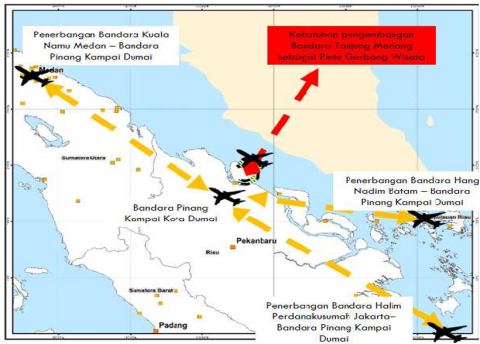
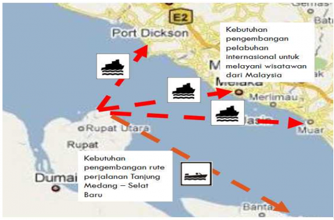
Government Regulation Number 50 of 2011 concerning the National Tourism Development Master Plan 2010-2025 explains that tourism accessibility is all types of transportation facilities and infrastructure that support the movement of tourists from the area of origin of tourists to tourism destinations and movement within the tourism destination area in relation to the motivation for tourist visits. Accessibility to and within Riau Province can be reached by land, sea and air transportation. Based on Figures 3 and 4, it can be explained that Rupat Island is accessible through several airports, namely Pinang Kampai Airport in Dumai City, Sultan Syarif Qasim II Airport in Pekanbaru City, and also Kuala Namu Airport in North Sumatra Province. Furthermore, Rupat Island is also accessible through ports that must be developed through the Dumai city international port area and also the development of port access from Tanjung Medang - Selat Baru and the Port of Melaka Malaysia, namely:
Figure 3. Air connectivity analysis of KSPN Rupat Island
Figure 4. Analysis of development needs for crossing transportation in Tanjung Medang
The condition of land accessibility in National Tourism Destination Area Rupat Utara, which is located on Rupat Island, takes the land route with road conditions partly paved with concrete rebates. But some are still dirt roads with quite alarming conditions, especially if it rains. Given the poor condition of the road, the travel time from Tanjung Kapal Roro Port to the tourist attraction is longer. In fact, at some points, four-wheeled vehicles often fall down, such as in Kadur Village, where the road conditions with soil construction plus rainy conditions make the road muddy and soft.
Road construction for the accessibility of tourist areas is the lifeblood of tourism development itself. Tourists will certainly object to going to tourist areas whose access is still very constrained. Even tourists who have come, potentially will not repeat their visit and what is worse is to tell and spread information that the condition of the damaged road will have an impact on the decline in tourist interest in visiting Rupat.
The absence of public transportation from Rupat to North Rupat or vice versa will be an obstacle. Tourists who come without private vehicles will find it difficult to reach other tourist areas. Road construction in the North Rupat area is important to improve accessibility between tourist attractions so that it makes it easier for tourists to reach existing tourist attractions. Air connectivity will be one of the driving factors of tourism in Rupat. Tourists can directly reach tourist destinations quickly and smoothly. For the initial stage, the development of flight routes from and to Dumai City's Pinang Kampai Airport can be a solution. But in the future, the development of an airport in North Rupat will answer accessibility issues.
The development of Pinang Kampai Airport must be supported by integrated intermodal transportation to Rupat Island in the form of rental vehicles heading to North Rupat or to the port of Dumai which is then continued by Speedboat to Tanjung Medang Port.
Furthermore, for the condition of the Dumai-Tanjung Medang port speed boat service along with the increase in tourists, it is necessary to consider increasing the frequency of trips. To improve accessibility it is also necessary to develop various new routes, including: Tanjung Medang-Selat Baru (Bengkalis Island). To increase the range of international services, it is necessary to develop international ports, including: Tanjung Medang-Port Dickson (Malaysia), Tanjung Medang-Malacca (Malaysia), and Tanjung Medang-Muar (Malaysia).
Furthermore, for the Analysis of Telecommunications, Information and Technology (ICT) Connectivity Conditions is also one of the concerns. Akaes Information Technology is a technology used to process data, including processing, obtaining, compiling, storing, manipulating data in various ways to produce quality information, namely information that is relevant, accurate and timely, which is used for personal, business and government purposes and is strategic information for decision making. Information and Communication Technology (ICT) as part of science and technology in general is all technology related to the capture, collection, processing, storage, dissemination and presentation of information.
Tourism undeniably serves as the driving force of the economy in Bali. In this case tourism creates a multiplier effect for all economic activities in Bali. For example: Tourism requires accommodation facilities, restaurants, bars and other supporting facilities. One hotel that is established will absorb a lot of labor. In addition, the hotel requires various suppliers to supply the needs of the hotel. The labor absorbed by the hotel also requires various kinds of necessities of life, so that various kinds of shopping centers appear, and so on the economic chain arising from tourism activities as a result of the multiplier effect.
The development of Technology, Information and Communication greatly supports the development of tourism, with ICT, information and communication can be done very quickly, efficiently and accurately which can reduce human error. As an example of ICT application, namely the use of LIBICA software, FIDELIO as a Hotel Information System Software Program. By using this software, information regarding the certainty of room reservations, certainty of guest accounts, guest information that will come to the hotel, guests who are staying at the hotel and guests who will leave the hotel. Information that is fast, precise and accurate will make guests satisfied and happy to stay at the hotel. Guest satisfaction will cause guests to return again for a vacation in Bali and stay at the hotel. When associated with the purpose of the establishment of a hotel, namely: Profit through guest satisfaction, and get a repeat business through word of mouth communication, the role of ICT is very vital. This condition also applies to other companies that act as economic entities (managing existing resources to be exchanged to the market so as to meet the needs and desires of the market / consumer so that market / consumer satisfaction is achieved) In the development of ICT in the Rupat tourism area, it needs to be supported by information systems and technology in booking hotel rooms, tourism promotions, and other information to support tourist satisfaction and comfort and convenience.
3.5 Amenity analysis
The supply and demand analysis of tourism facilities in the North Rupat national tourism strategic area is very diverse and is described as follows:
The offer of tourism facilities in the North Rupat national tourism strategic area consists of various aspects that can be enjoyed and used including the following: Offer of Lodging Facilities at Tourist Attractions, Offer of Culinary or Restaurant Facilities, Offer of Port Facilities Offer of Road Facilities in Tourism Objects, Offer of Tidal Facilities, Tourist Attraction Pavilion Facility Offerings, Viewpoint Facility Offerings, Banana Boat Attraction Facility Offerings, Sailboat Attraction Facility Offerings, Children's Game Facility Offerings, Offers of Public WC Facilities for Tourists, Offer of Seating Facilities at Tourist Attractions, and Offers of Street Lights in Tourist Attractions.
Demand for tourism facilities in the North Rupat national tourism strategic area consists of various aspects that can be enjoyed and used including the following: Demand for ATV Game Facilities, Demand for Kros Motorcycle Game Facilities, Request for Diving Equipment Facilities, Request for Water Sports Facilities, Request for Rupat Island Tourism Map Facility, Information Center Facility Request, Tour Guide Facility Request, Rinse Room Facility Request, Request for Vehicle Parking Facilities at Tourist Attractions and Request for Souvenir Sales Facilities.
3.6 Community analysis
Analysis of the Community sector in Visiting Tourism can be explained by explaining that Strengths consist of eight points, namely the area is developing, the community environment is relatively pristine (natural), strong commitment of the community, community environment for tourism activities, availability of supporting facilities, original community culture, community hospitality. The existence of Pokdarwis. While the opportunities consist of seven points, namely cultural similarities with neighboring countries, developing culture, community activities, original cultural development, strong local institutions, event implementation plans, potential community diversity. When viewed at the weaknesses consist of five points, namely low environmental awareness, relatively unstable community conditions, potential pollution by the community, limited human resources and institutions, lack of basic data on cultural tourism attractions. The threats consist of four points, namely the similarity of community culture, Free Trade Expansion, sand mining by the community. So, it can be concluded that the community in supporting tourism in the North Rupat national tourism strategic area has great strengths and opportunities to be developed.
Community Competence in Small and Medium Enterprises in the North Rupat national tourism strategic area in advancing the tourism sector. The small and medium business sector is very important in improving the welfare of the community around the tourist attraction for the need for community involvement in participating in tourism development in North Rupat.
Based on the empirical findings and policy review, this study proposes a tourism development model comprising three key pillars: First, ecological Conservation Zoning: Establishment of protected ecological zones such as mangrove forests and coastal habitats, supported by eco-certification systems and environmental impact assessments in tourism investment planning [7].
Second, CBT Empowerment: Development of CBT cooperatives focusing on homestays, guided eco-tours, and local craft industries, facilitated by capacity-building programs and microfinancing. Such a model increases local ownership and ensures benefit distribution [20].
Third, institutional Integration and Policy Synchronization: Formation of a multi-stakeholder tourism governance body at the regency level, involving local government, customary institutions, and environmental NGOs. This mechanism aims to synchronize national tourism goals with local ecological priorities and cross-border development strategies.
This integrated model aligns with the principles of sustainable tourism as outlined by the UNWTO [7], which emphasize environmental integrity, social equity, and economic viability. It also corresponds with borderland development theory, which calls for multi-scalar cooperation and localized governance in managing peripheral territories [10].
The case of Rupat Island illustrates that sustainable tourism in border areas cannot be pursued in isolation from broader regional development goals. Policies must be sensitive to the unique socio-political and ecological conditions of borderlands, including security concerns, infrastructure gaps, and cultural plurality. Integrating tourism into cross-sectoral planning—particularly in transportation, environment, and education—will enhance the island’s resilience and attract low-impact, high-value tourism markets.
Moreover, the experience from Rupat Island suggests the need for adaptive, locally-informed policy frameworks that move beyond top-down directives. Participation of local communities in decision-making, transparency in investment processes, and continuous monitoring of environmental indicators are essential to the long-term success of sustainable tourism in border regions [12].
The integration of environmental sustainability with borderland development represents a critical pathway for achieving equitable and resilient tourism in peripheral regions. This study has examined Rupat Island, a designated National Tourism Strategic Area situated in Indonesia’s maritime border zone, as a case study to explore the possibilities and challenges of implementing such an integrative model.
The findings underscore that while Rupat Island holds considerable ecological and cultural tourism potential, its current development trajectory is constrained by environmental degradation, institutional fragmentation, and limited community engagement. These constraints are symptomatic of broader structural issues prevalent in border regions, where governance complexities and spatial marginalization hinder sustainable development outcomes.
In response, the proposed model emphasizes three interdependent pillars: ecological conservation zoning, CBT empowerment, and institutional integration. This model advocates for a multi-scalar and participatory governance framework that aligns national tourism objectives with localized ecological and socio-economic realities. Importantly, it situates tourism not merely as an economic activity, but as a strategic instrument for environmental stewardship and social inclusion in borderland contexts.
The case of Rupat Island reveals that sustainable tourism can serve as a transformative mechanism in Indonesia’s outer islands, provided that development strategies are anchored in ecological sensitivity, community ownership, and policy coherence. As such, this study contributes to the growing discourse on place-based sustainability by offering practical and theoretical insights into how tourism can be harnessed as a tool for integrated borderland development.
Future research may build upon this work by conducting longitudinal impact assessments of tourism activities in similar border regions, exploring comparative models across Southeast Asia, and further investigating the nexus between tourism, security, and sovereignty in maritime border zones. Such inquiries are vital to ensuring that tourism development in peripheral areas remains inclusive, adaptive, and environmentally sustainable.
[1] Harris, T., van Schendel, W. (2016). Borderland Infrastructures: Trade, Development, and Control in Western China. Amsterdam University Press.
[2] Kogachi, A., Shaw, R. (2023). Application of sustainable livelihood approach (SLA) to address climate-induced risks through the lens of Africa borderland. Climate, 11: 65. https://doi.org/10.3390/cli11030065
[3] Bangun, B.H., Kinanti, F.M., Darajati, M.R. (2024). Economic security in border areas: The fulfillment of community welfare. Lampung Journal of International Law (LaJIL), 6(2): 69-82. https://jurnal.fh.unila.ac.id/index.php/lajil/article/view/3355/2115.
[4] Ministry of Tourism and Creative Economy. (2020). National tourism strategic area development framework. Jakarta.
[5] Afrizal, A., Nasution, M.S., Mayarni, M. (2022). The border development in Biski Beach tourism in Riau Province. Journal of Governance, 7(1): 222-238. http://doi.org/10.31506/jog.v7i1.14556
[6] Fadli, M., Susilo, E., Puspitawati, D., Ridjal, A.M., Maharani, D.P., Liemanto, A. (2022). Sustainable tourism as a development strategy in Indonesia. Journal of Indonesian Tourism & Development Studies, 10(1): 23-33. http://doi.org/10.21776/ub.jitode.2022.010.01.04
[7] Organización Mundial del Turismo. (2018). Tourism for Development: Volume I: Key Areas for Action. United Nations World Tourism Organization, Madrid. https://doi.org/10.18111/9789284419722
[8] Hall, C.M. (2008). Tourism Planning: Policies, Processes and Relationships. Pearson Education.
[9] Gössling, S., Peeters, P. (2015). Assessing tourism's global environmental impact 1900-2050. Journal of Sustainable Tourism, 23(5): 639-659. https://doi.org/10.1080/09669582.2015.1008500
[10] Scott, J.W. (2009). Bordering and ordering the European neighbourhood: A critical perspective on EU territoriality and geopolitics. Trames, 13(3): 232-247.
[11] Dinarto, D. (2015). “Easternization” of post-Western international order: Appertaining Confucianism into Bandung Conference legacy. Global South Review, 2(2): 103-114. https://doi.org/10.22146/globalsouth.28866
[12] Bramwell, B., Lane, B. (2011). Critical research on the governance of tourism and sustainability. Journal of Sustainable Tourism, 19(4-5): 411-421. https://doi.org/10.1080/09669582.2011.580586
[13] Dredge, D., Jamal, T. (2015). Progress in tourism planning and policy: A post-structural perspective on knowledge production. Tourism Management, 51: 285-297. https://doi.org/10.1016/j.tourman.2015.06.002
[14] Miles, M.B., Huberman, A.M. (1994). Qualitative Data Analysis: An Expanded Sourcebook. Sage Publications.
[15] Salam, S., Gurusi, L., Nurcahyo, E., Suhartono, R.M., Suherman, L.O.A., Hezradian, F., Hezraria, R.F. (2025). Preventing illegal sand mining through community-based environmental education in Buton’s coastal ecosystem. BIO Web of Conferences, 180: 02001. https://doi.org/10.1051/bioconf/202518002001
[16] Dahles, H. (2000). Tourism, small enterprises and community development. In Tourism and Sustainable Community Development. Routledge.
[17] Papamichail, T. (2019). SPATIAL SYNERGIES - Synergies between formal and informal planning as a key concept towards spatial conflicts – The case of tourism-oriented railway development in the Peloponnese. Doctoral Thesis, ETH Zurich. https://doi.org/10.3929/ethz-b-000375705
[18] Gössling, S., Hall, M.C. (2006). Tourism and Global Environmental Change. Routledge. https://doi.org/10.4324/9780203011911
[19] Fitriani, Y., Suhud, U., Rizan, M. (2025). Exploring community perceptions of post-mining coastal ecotourism: A qualitative study on sustainable tourism development in Bangka Belitung. Greenation International Journal of Tourism and Management, 3(1): 112-119. https://doi.org/10.38035/gijtm.v3i1.386
[20] Scheyvens, R. (1999). Ecotourism and the empowerment of local communities. Tourism Management, 20(2): 245-249. https://doi.org/10.1016/S0261-5177(98)00069-7