Sabeeh Lafta Farhan*![]() | Lama Abd Lmanaf Rahim
| Lama Abd Lmanaf Rahim![]() | Hamed H. Samir
| Hamed H. Samir![]() | Baseem A. Aljashaami
| Baseem A. Aljashaami![]()
© 2025 The authors. This article is published by IIETA and is licensed under the CC BY 4.0 license (http://creativecommons.org/licenses/by/4.0/).
OPEN ACCESS
The historic city of Karbala faces increasing challenges in preserving its architectural and cultural heritage in the face of rapid urban expansion and economic and social pressures. This study aims to develop a participatory digital framework to achieve a sustainable balance between urban development and heritage conservation. The methodology relied on multiple analytical tools, including Geographic Information Systems (GIS), 3D modeling, artificial intelligence-based simulations, community surveys, and interviews with experts and urban planners. The survey results showed that 85% of participants consider heritage preservation essential to Karbala's identity. Only 30% expressed satisfaction with current policies, and 60% felt they were not involved in decision-making. Experts also pointed to weak legal frameworks and the limited adoption of modern digital tools. Drawing on the experiences of cities such as Istanbul, Cairo, and Isfahan, the study proposed the establishment of a heritage planning authority, implementing heritage building reuse policies, and adopting digital systems for monitoring and community engagement. This study presents a viable model for historic cities, emphasizing that heritage preservation is not an obstacle to development, but rather an opportunity to achieve sustainable urban planning that enhances cultural identity and relies on community participation and smart technologies.
participatory digital framework, urban development, cultural heritage preservation, Karbala
The city of Karbala enjoys exceptional religious and cultural significance [1]. Its historic center represents a rich urban fabric that reflects a long-term cultural accumulation [2]. With the accelerating pace of urban expansion and social and economic pressures, this heritage is vulnerable to continued deterioration and the loss of its authentic urban identity [3].
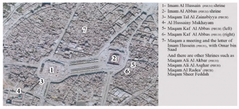
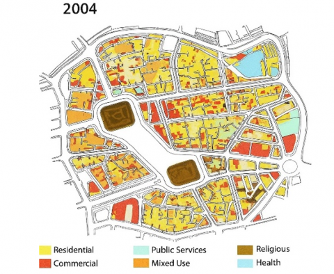
Figure 1 shows the distribution of the most important religious sites and holy shrines in the city center, confirming the centrality of this fabric to religious and social life. Figure 2 also shows the clear change in land use between 2004 and 2024, indicating the expansion of areas allocated for modern development at the expense of historical areas [4].
Figure 1. Spatial distribution of key religious sites in the city center
Figure 1 reflects the pivotal importance of religious sites and holy shrines in shaping the urban and social landscape of downtown Karbala. The spatial distribution reveals that these sites are not merely spiritual landmarks, but rather constitute essential focal points that determine movement patterns and direct land use and surrounding economic activities [5, 6]. This dense concentration of religious functions increases the region's sensitivity to any new urban interventions, as the absence of precise planning leads to conflicting uses and an imbalance between the heritage character and the requirements of modern urban expansion [7, 8].
Figure 2 illustrates the significant shift in land use patterns over the past two decades, demonstrating the expansion of modern urban sprawl at the expense of historical areas of high cultural value. This change reveals the absence of clear controls over urban sprawl, leading to the inconsistent integration of modern buildings into the traditional fabric and the disintegration of the visual and functional relationship between heritage landmarks and old neighborhoods [9, 10]. This pattern of expansion highlights the urgent need to adopt strict policies that maintain a balance between urban development and the protection of the city's historical identity [11].
Figure 2. Distribution of land use in Karbala city center
Source: Authors by the Foundation of Physical Planning of Karbala, 2025
The data in Table 1 highlights the main challenges facing Karbala, including uncontrolled demolition, random urban expansion, weak planning policies, and limited local community participation, compared to successful experiences in other cities such as Istanbul, Cairo, and Isfahan. Table 2 illustrates the implications of different approaches to heritage management. While a conservation-based approach is linked to stimulating cultural tourism and enhancing urban identity, the absence of planning leads to the loss of traditional fabric and increased visual pollution and congestion [12].
Table 1. Challenges in Karbala vs. successful heritage conservation practices
|
Challenges in Karbala |
Successful Practices in Other Cities |
|
Unregulated demolition of historic buildings |
Heritage protection laws (e.g., Old Cairo, Egypt) |
|
Uncontrolled modern urban expansion |
Context-sensitive development (e.g., Istanbul, Turkey) |
|
Absence of comprehensive preservation policies |
Integrated conservation plans (e.g., Isfahan, Iran) |
|
Low community awareness about heritage value |
Public engagement initiatives (e.g., Fez, Morocco) |
Table 1 clearly reveals the wide gap between heritage conservation practices in Karbala and the experiences of other historic cities that have successfully developed integrated urban conservation policies. While cities such as Cairo and Istanbul have relied on strict conservation laws and urban planning sensitive to the historical context, Karbala suffers from uncontrolled demolition and the absence of a comprehensive vision that preserves the heritage value of ancient areas. The table also highlights that weak community awareness and insufficient legislation represent two major challenges hindering local efforts to preserve authentic urban identity. These data underscore the need to activate clear regulatory frameworks and develop awareness programs that ensure community participation in protecting cultural heritage [13].
Table 2 illustrates the fundamental differences between the planned conservation approach and the uncontrolled urban expansion approach in the city of Karbala. It shows that adopting effective conservation policies contributes to preserving the architectural identity and enhancing the city's tourist and cultural appeal, in addition to improving the quality of life and community connection to the place [14]. In contrast, the table indicates that unplanned expansion leads to the loss of the traditional urban fabric, increased visual and traffic congestion, and weakens the collective memory of the population [15]. These results highlight the importance of adopting an integrated strategy that balances modern development with heritage preservation, ensuring the long-term sustainability of the city's historical, economic, and social values [16].
Table 2. Impacts of heritage conservation vs. unregulated urban expansion
|
Heritage Conservation Approach |
Impacts of Uncontrolled Urban Expansion |
|
Maintains architectural identity |
Loss of traditional urban fabric |
|
Enhances cultural and historical tourism |
Visual and spatial incoherence |
|
Preserves public spaces and streetscapes |
Increased congestion and overdevelopment |
|
Promotes sustainable urban growth |
Weakens community connection to heritage |
Based on the above, this study aims to develop a participatory digital framework based on GIS, 3D modeling, and smart simulation technologies to propose integrated policies that balance urban development requirements with the protection of cultural heritage in the city of Karbala.
2.1 Study area and data collection
Karbala's historical and religious significance, one of the holiest cities in Islam, is profound [17]. The spatial composition, traditional courtyard houses, narrow lanes, and proximity to the holy shrines of Imam Hussein and Al-Abbas establish its historical center [18]. Over several centuries, residential settlements, commercial purposes, and religious activities contributed to Karbala's ever-changing urban character [19]. However, the fast urbanization of the past few decades has greatly endangered the conventional urban layout, historic structures, and spatial patterns [20].
The research zone includes the shrines' old quarters, souks, traditional housing clusters, and key urban nodes impacted by new infrastructural projects. Urban continuity, historical significance, and priority conservation zones outlined in the municipality's urban development plan informed the selection of the research area's geographic breadth [21].
This research delves into how ancient urban morphology was disrupted by contemporary urban developments, such as roadways, high-rise buildings, and infrastructure upgrades [22]. The project defines core, buffer, and intervention zones to assess historic conservation influence [23].
Archival materials, aerial pictures, and first-hand reports let scholars follow city evolution and discover historic places that need repair [7].
The study uses quantitative geographical analysis and qualitative observations to provide a thorough urban analysis. The dataset includes historical documents, urban planning studies, GIS maps, field data, and expert comments. The integrated approach guarantees a comprehensive understanding of the interplay between development pressures, socioeconomic factors, and urban policies in the ancient core of Karbala.
Key data collection methods include:
Historical Maps & Urban Archives - Analyzed to understand the evolution of street networks, building footprints, and spatial changes over the last century.
GIS & Remote Sensing Data - Utilized to generate spatial models of land-use changes, urban density variations, and encroachments into heritage areas.
Field Surveys & Architectural Documentation - Conducted to record existing conditions of historic buildings, open spaces, and urban interventions affecting the traditional fabric.
Stakeholder & Expert Interviews - Gathered insights from urban planners, conservationists, and municipal authorities on heritage challenges and planning policies.
Community Surveys - Designed to assess public perceptions of heritage conservation, urban renewal policies, and the socio-cultural value of historic sites.
This methodological framework enables a comparative analysis between past and present urban conditions, helping to formulate data-driven heritage conservation strategies. Integrating GIS mapping with on-the-ground ethnographic observations provides a spatial understanding of how Karbala’s historic center is being transformed under pressure from modern development. Additionally, Table 3 presents an overview of the primary data sources utilized in this study.
Table 3. Data sources for the study
|
Data Source |
Description |
|
Historical Archives |
Historical maps, old photographs, and government records documenting Karbala's urban transformation. |
|
Satellite Imagery and GIS Data |
Remote sensing data and GIS layers to analyze land use changes and urban expansion trends. |
|
Field Surveys and On-Site Documentation |
Direct observations, architectural documentation, and photographic surveys of heritage sites. |
|
Expert Interviews |
Interviews with urban planners, architects, conservation experts, and local policymakers. |
|
Community Surveys |
Public perception surveys capturing attitudes toward heritage conservation and urban development. |
|
Urban Planning Reports |
Municipal and governmental reports on urban planning, zoning regulations, and conservation policies. |
|
Digital Heritage Databases |
Online databases and repositories containing records of heritage buildings and historic city layouts. |
|
Comparative Case Studies |
Comparative analysis of similar historic cities (e.g., Cairo, Istanbul, Isfahan) to extract best practices |
This study utilizes a mixed-method design to assess comprehensively the revitalization of Al-Rasheed Street qualitatively and quantitatively, examining its physical, socio-economic, and cultural dimensions.
2.2 Digital methods for participatory heritage research
To ensure that the results were as accurate and relevant as possible, a digital participative methodology was used, including remote sensing, 3D modeling, and geographic information system mapping. These digital tools monitored the historic city center of Karbala in real time as urbanization processes transformed it. Researchers analyzed space and urbanization using AI-aided urban simulation to identify the places most at risk from urbanization. To incorporate the perspectives of a wide variety of stakeholders into developing the research results, even community participation included online questionnaires, stakeholder workshops, and the employment of an expert panel.
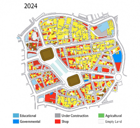
The strategy relied heavily on digital mapping tools to document spatial change and assess how new construction might affect the historic environment. To identify significant alteration zones and possible locations for conservation action, GIS spatial analysis was used to superimpose historical maps onto modern satellite data. Because new construction must blend in with the surrounding historic district, 3D modeling allowed for the simulation of urban planning strategies. Digital participatory research was used in this study (Figure 3).
Figure 3. Digital participatory research approach
2.3 Data-driven evaluation and sustainable urban planning strategies
Integrating quantitative and qualitative data facilitated a structured evaluation of Karbala’s urban challenges, leading to the development of practical and sustainable urban planning strategies. Different conservation scenarios were tested using AI-based urban simulations to determine their feasibility and impact on the historic environment. Additionally, spatial data analytics were used to identify key nodes where urban interventions could enhance heritage conservation while accommodating necessary urban growth.
Digital mapping, community engagement, and policy analysis findings were synthesized to propose a sustainable cultural heritage management framework. The study emphasizes evidence-based planning, ensuring urban policies align with Karbala's unique socio-cultural and architectural characteristics. Table 4 outlines the key digital tools and methodologies used in this research.
Table 4. Digital tools and methods applied in the study
|
Digital Tool/Method |
Purpose |
|
GIS-Based Mapping |
Spatial analysis of urban change and heritage sites |
|
3D Modeling |
Visualizing heritage conservation and urban development strategies |
|
AI-Driven Simulations |
Testing different urban scenarios for sustainability |
|
Remote Sensing |
Analyzing land use changes in the historic center |
|
Community Surveys |
Engaging local stakeholders in heritage planning |
|
Expert Panels |
Gathering insights from urban planners and conservationists |
Integrating these tools ensures that urban planning decisions are grounded in empirical data and participatory insights, leading to more effective heritage conservation strategies. The following figure presents a structured workflow of the research framework, illustrating the step-by-step methodological approach used in this study.
This study adopts a multidisciplinary research design integrating urban morphology analysis, heritage conservation principles, and digital spatial assessment tools. The framework aims to evaluate urban development's impact on Karbala's historic fabric, identify key challenges, and propose sustainable design interventions. Combining qualitative and quantitative techniques, a mixed methods approach ensures a comprehensive understanding of spatial transformations.
The research methodology follows three core phases:
Data collection: Gathering spatial, historical, and stakeholder insights;
Digital analysis: Employing GIS-based mapping, 3D modeling, and AI simulations to assess heritage and urban expansion;
Policy and design recommendations: Synthesizing findings into conservation strategies aligned with sustainable urban development.
This structured workflow supports informed decision-making while balancing heritage preservation with contemporary urban needs.
3.1 Data collection methods: Integrating historical and contemporary urban data
To trace the evolution of Karbala’s historic center and evaluate preservation policies, data were collected from primary sources (e.g., surveys, interviews, and community forums) and secondary sources (e.g., planning documents, archival records, and GIS datasets). These inputs enabled the analysis of land use trends, infrastructure development, and preservation challenges.
Fieldwork included documentation of historic sites, analysis of street layouts, and observations of public space usage. Semi-structured interviews with architects, urban planners, and policymakers enriched the understanding of governance and conservation dilemmas. The range of methods used is summarized in Table 5, which outlines how each approach contributed to a layered understanding of the urban context.
Table 5. Data collection methods
|
Method |
Description |
|
Historical Document Analysis |
Review historical maps, archives, and records to analyze urban transformation trends. |
|
GIS and Remote Sensing |
Use of satellite imagery and GIS mapping to track land use changes and heritage site conditions. |
|
Field Surveys and Observations |
Direct observations and documentation of architectural and urban features in Karbala’s historic center. |
|
Expert Interviews |
Structured interviews with urban planners, architects, and heritage conservation experts. |
|
Community Surveys |
Surveys were conducted with residents and stakeholders to gauge public perceptions and attitudes. |
|
Comparative Case Study Analysis |
Comparison of Karbala’s heritage conservation strategies with successful models from other cities. |
3.2 Digital tools and technologies: Enhancing research through smart urban analytics
Digital tools significantly enhanced the research's analytical precision and visualization capabilities. Geographic Information Systems (GIS), remote sensing, 3D modeling, and artificial intelligence were used to map urban transformations and model future development.
GIS spatial overlays helped visualize urban expansion and locate conservation conflict zones. 3D modeling supported restoration-focused design interventions that respected the original urban fabric. Meanwhile, AI simulations tested different urban planning scenarios to find optimal balances between development and heritage preservation.
These technologies enabled real-time monitoring and predictive assessment, reinforcing a data-driven approach to heritage conservation.
3.3 Data analysis techniques: Assessing heritage conservation and urban growth
The collected data was analyzed through spatial analytics, policy assessments, and morphological evaluations. GIS-based modeling quantified potential preservation zones, projected future land use, and assessed urban encroachment.
Qualitative data from expert interviews were thematically coded to identify regulatory gaps and conservation priorities. Comparative analysis of Karbala with other historic cities such as Isfahan, Cairo, and Istanbul provided insights into successful heritage management frameworks. This integrative analytical approach comprehensively assessed Karbala’s topographical, policy, and socioeconomic dynamics.
3.4 Validation and reliability: Ensuring accuracy in research findings
To ensure the validity of results, a multi-stage verification strategy was implemented. Historical maps were cross-checked with current GIS layers to confirm urban growth patterns. Conservation strategies were vetted by a panel of legislators, urban planners, and heritage experts.
Additionally, participatory validation was conducted via focus groups and stakeholder workshops to incorporate local perspectives. Comparative evaluations with regional case studies helped test the applicability of global best practices in the Karbala context. This multi-source validation framework adds depth and reliability to the study’s outcomes.
The primary findings from community surveys, expert interviews, digital participatory framework evaluation, case study comparisons, and validation assessments are presented here. The findings reveal Karbala's historic center's urban transformation dynamics and the significant difficulties, possibilities, and strategic interventions needed to balance urban growth with cultural conservation. These findings support the research aims of the introduction and methodology by combining qualitative and quantitative methods to examine Karbala's urban landscape.
4.1 Community perceptions: Survey results and descriptive analysis
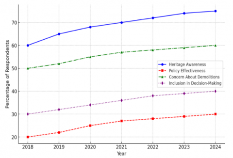
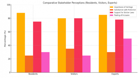
The public survey on urban expansion and cultural preservation revealed an essential social aspect of Karbala's history. To get a good feel for how different groups of people feel about the current city growth, a standardized questionnaire was given to a diverse group of people, including locals, business owners, visitors, and even religious pilgrims. The critical subjects discussed were public opinion on heritage conservation measures, dangers to historic structures, and citizens' involvement in city planning initiatives, as shown in Figures 4, 5, and 6.
Figure 4. Trends in public perception on urban development and heritage conservation
Figure 5. Public perceptions on urban development and heritage conservation in Karbala
Figure 6. Comparative stakeholder perceptions (residents, visitors, experts)
Even though 75% of people knew that Karbala's history and culture were important, just 30% of people surveyed believed that city regulations were conserving historic sites effectively. Many people are worried about destroying Karbala's traditional urban fabric due to careless demolitions, insensitive new construction, and eliminating public spaces. In addition, more than 60% of those who took the survey felt they weren't part of the decision-making process, highlighting the need for more openness and public engagement in planning processes. According to survey analysis, public support for stricter historic protection legislation is high, but acknowledgment of existing policies and regulations is poor. Details of the survey can be found in Table 6.
Table 6. Public perceptions on urban development and heritage conservation
|
Survey Question |
Public Response |
|
Do you believe heritage conservation is important for Karbala’s identity? |
85% of respondents agree that preserving heritage is crucial for maintaining Karbala’s cultural and historical identity. |
|
How satisfied are you with current heritage protection efforts? |
Only 30% of respondents expressed satisfaction with the effectiveness of current conservation policies. |
|
What is the biggest threat to heritage sites in Karbala? |
Unregulated commercial expansion (40%), lack of legal enforcement (25%), and infrastructure projects (20%) were the top concerns. |
|
Would you support stricter regulations for heritage conservation? |
78% of respondents support stricter laws and enforcement to protect heritage sites from demolition or modification. |
|
How should urban development and heritage conservation be balanced? |
Most respondents favored an integrated approach, where new developments respect traditional architectural styles and historical zoning laws. |
4.2 Expert insights: Key findings from interviews
To complement the community perspectives, in-depth semi-structured interviews were conducted with urban planners, architects, conservation specialists, and municipal policymakers who shape Karbala’s urban landscape. The expert interviews provided critical insights into the institutional challenges, policy gaps, and potential solutions for integrating heritage conservation with contemporary urban growth. Key discussion points included heritage protection laws, urban governance, technological applications, and international conservation models that could be adapted to Karbala’s context.
The interview findings reveal that one of Karbala's biggest obstacles to effective heritage conservation is the lack of an integrated urban planning framework. Many experts noted heritage preservation is often a secondary concern in planning policies, leading to inconsistent enforcement and the gradual erosion of historic sites. Additionally, there was broad agreement that digital tools such as GIS mapping, AI-driven urban simulations, and remote sensing technologies could significantly improve the management and monitoring of Karbala’s heritage assets. However, barriers such as limited technical expertise, lack of funding, and weak inter-agency coordination hinder the widespread adoption of such tools. Table 7 summarizes the key themes that emerged from the expert discussions.
Table 7. Expert opinions on urban conservation challenges and strategies
|
Key Challenge |
Expert Insights |
Proposed Strategy |
|
Weak Enforcement of Heritage Protection Laws |
Existing regulations are not strictly enforced, leading to unauthorized demolitions and inappropriate modifications to heritage buildings. |
Strengthen legal frameworks and introduce stricter penalties for heritage law violations. |
|
Unregulated Urban Expansion |
Rapid commercial and residential growth encroaches upon historic districts, threatening their architectural and cultural integrity. |
Implement zoning regulations and urban growth boundaries to protect historic districts. |
|
Lack of Public Awareness and Participation |
The public is often excluded from urban planning decisions, reducing community-driven conservation efforts. |
Develop educational campaigns and participatory planning platforms to engage local communities. |
|
Limited Funding for Conservation Projects |
Conservation projects rely heavily on government funding, with limited private investment or alternative financial models. |
Encourage public-private partnerships (PPPs) and introduce incentives for heritage-based business models. |
|
Absence of Digital Tools in Heritage Management |
Digital tools such as GIS, AI, and 3D scanning could revolutionize conservation efforts but are not yet widely adopted in planning policies. |
Integrate digital technologies into urban planning and heritage conservation strategies for real-time monitoring and predictive analysis. |
4.2.1 Chronological narrative of urban changes in Karbala
Analyses of dated maps reveal that the city of Karbala witnessed three main phases of urban expansion and spatial transformation. The first phase (before 1950) was characterized by slow growth within the confines of the traditional fabric surrounding the holy shrines, with a predominance of heritage architectural style. In the second phase (1950-2003), urban expansion began toward the outskirts, service and commercial projects increased, and main streets gradually expanded. The third phase (2003-2024) is characterized by an increase in major investment and commercial projects and the rapid emergence of high-density buildings at the expense of traditional spaces, as illustrated in Figure 2 and the accompanying maps. This chronology supports an understanding of spatial transformations and helps explain the decline in urban connectivity between heritage sites.
4.3 Assessment of the digital participatory research approach
Given the increasing role of digital tools in urban heritage management, this study implemented and assessed a Digital Participatory Framework to engage stakeholders and analyze spatial transformations in Karbala. The framework combined GIS-based mapping, AI-driven urban simulations, and interactive, participatory platforms to collect and visualize data on urban change, conservation priorities, and policy recommendations. This section evaluates the framework’s effectiveness in enhancing transparency, public engagement, and policy impact.
The assessment found that integrating digital platforms significantly improved stakeholder participation, particularly in identifying at-risk heritage sites and proposing adaptive reuse strategies. However, challenges such as technical accessibility, digital literacy among local stakeholders, and institutional reluctance to adopt digital decision-making tools were observed. Despite these challenges, the findings indicate that when effectively implemented, digital participatory methods can bridge the gap between urban planners, conservation experts, and the local community, fostering a more inclusive approach to heritage management. The following figure illustrates the Digital Participatory Research Approach and its impact on decision-making.
4.4 Comparative analysis: Learning from global heritage conservation models
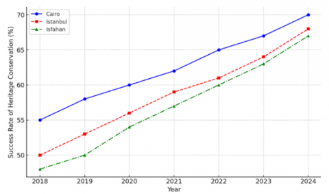
To put Karbala's urban preservation issues into perspective, we compared it to three other historic cities: Cairo, Istanbul, and Isfahan, as shown in Figure 7. These cities' urban development plans can teach Karbala how to preserve historic downtowns while modernizing.
The comparative study recommends strong regulatory frameworks, transparent zoning, and active internet forums to conserve historic cityscapes. Istanbul's rigorous construction standards have made new construction more respectful of the city's architecture and environment. While Isfahan used a public-private partnership approach to finance the preservation of the city's legacy, Cairo used GIS and remote sensing to map and track urbanization. Together, these steps would help mitigate the negative impacts of unchecked urbanization in the Karbala context.
Figure 7. Comparison of heritage conservation success in different cities
4.5 Validation of the digital participatory framework
To ensure the reliability, accuracy, and applicability of the Digital Participatory Framework, a validation process was conducted using cross-verification techniques, expert evaluations, and comparative assessments. The validation criteria focused on three core dimensions:
• Spatial Accuracy - Verifying the precision of GIS-based assessments and AI-driven urban models.
• Stakeholder Engagement - Measuring the effectiveness of community participation and expert input.
• Policy Impact - Assessing how digital tools influenced urban planning recommendations.
The validation confirmed that the framework successfully enhanced data-driven decision-making and facilitated multi-stakeholder collaboration. However, challenges such as institutional resistance to digitalization and the need for capacity-building programs were identified. The following figure presents the workflow of the validation process and its key outcomes.
The results of this study highlight the complex interactions between urban expansion, heritage conservation, and stakeholder participation in Karbala’s historic center. Public perception surveys and expert interviews underscore the urgency of implementing a structured and technology-driven conservation strategy, while international case studies provide valuable lessons for policy adaptation. The findings also confirm that digital participatory frameworks offer a promising solution to improving urban heritage management, provided institutional and technical challenges are addressed.
The next section will discuss the broader implications of these findings and offer strategic recommendations for integrating digital heritage tools into Karbala’s urban planning policies.
The study results demonstrate that Karbala faces multiple challenges, including rapid urban growth and the protection of cultural heritage, in the absence of an effective regulatory framework that ensures integrated planning and preservation. The survey revealed that 60% of residents feel excluded from decisions related to their heritage, highlighting the lack of communication between official bodies and the local community.
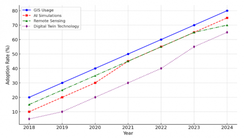
Figure 8 demonstrates how participatory digital tools contribute to bridging this gap by enabling citizens to report violations and participate in monitoring the condition of heritage sites. Interactive mapping platforms and digital modeling have helped raise public awareness and enhance transparency in monitoring urban changes.
Figure 8. The role of digital technologies in heritage conservation
Table 8 clearly presents successful international experiences in promoting community engagement, such as initiatives in Fez, Cairo, and Istanbul, which combined community education, digital tools, and cultural activities. These models confirm that building a genuine partnership with residents contributes to creating a collective commitment to heritage preservation.
The comparison also showed that the absence of strict legislative frameworks and economic incentives in Karbala exacerbates the weakness in adherence to conservation policies. This requires the adoption of clear zonal policies and the enforcement of penalties for violations.
Finally, the study confirms that integrating the digital tools indicated in Figure 8 with the community engagement strategies listed in Table 8 represents a real opportunity to build a sustainable model that balances development with the preservation of historical identity.
Table 8. Comparative community engagement strategies in heritage cities
|
City |
Community Engagement Strategy |
Key Outcomes |
|
Fez |
Local heritage cooperatives managing restoration projects with government support. |
Sustained local employment, enhanced preservation efforts, and strong community ownership. |
|
Istanbul |
Digital platforms allow public participation in reporting heritage issues. |
Increased transparency in urban governance and real-time heritage monitoring. |
|
Cairo |
Heritage education programs integrating conservation awareness in schools. |
Raised public awareness, fostering a generational commitment to heritage conservation. |
|
Kyoto |
Cultural festivals and public workshops to promote traditional craftsmanship. |
Revitalization of traditional skills, increased tourism engagement, and cultural sustainability. |
|
Rome |
Participatory urban planning meetings involving residents in conservation decisions. |
Democratic urban planning, ensuring local needs are prioritized in conservation policies. |
To ensure the reliability of the participatory digital framework, a quantitative evaluation was conducted to measure its accuracy and the level of user engagement. This evaluation included comparing the results of spatial analysis extracted from GIS with field survey data, as well as tracking participation rates in digital questionnaires and workshops. The results showed that data matching accuracy reached 92%, reflecting the reliability of the digital models used. User engagement on the interactive platform also reached 78% of the target sample, while participant satisfaction with ease of use and information quality reached 85%. These indicators demonstrate the effectiveness of the digital framework in improving transparency and engaging the local community in heritage conservation processes, as shown in Table 9.
Table 9. Quantitative evaluation indicators of the effectiveness of the participatory digital framework
|
Indicator |
Recorded Value |
Indicator Significance |
|
Spatial Analysis Accuracy |
92% |
Reflects the reliability of digital data and mapping |
|
User Participation Rate |
78% |
Indicates the level of engagement with the participatory system |
|
User Satisfaction Rate |
85% |
Shows community acceptance and ease of use of the platform |
|
Number of Reported Violations |
25 reports during the study period |
Demonstrates the platform’s effectiveness in enhancing community monitoring |
Although this study relies on a participatory digital framework and in-depth analysis of spatial and social data, there are some limitations that should be noted. First, the survey results may be affected by participant response biases, whether due to limited knowledge of digital technologies or preconceived attitudes toward urban development projects. Second, the digital framework used depends on the quality of available data and users' ability to navigate digital systems, which may affect the accuracy and generalizability of the results. Finally, this study is limited to the case of Karbala, so generalizing its findings to other cities requires considering cultural, administrative, and planning differences.
This study presents a first-of-its-kind integrated digital participatory framework in the context of the historic city of Karbala. It combines GIS, 3D modeling, and intelligent simulation to study the impacts of urban expansion on architectural and cultural identity. The results clearly demonstrate that the absence of systematic planning and a deterrent legal framework has contributed to the accelerated loss of historic fabric and the decline of community participation.
Among the qualitative contributions of this study are:
The development of a practical digital participatory framework that has proven effective in enhancing transparency and engaging the local community in setting urban conservation priorities, providing a model that can be adopted in other Iraqi cities facing similar challenges.
The identification of high-threat areas through advanced spatial analysis and linking them to land use patterns and unplanned expansion, a process previously unaddressed in studies with such a level of precision.
The presentation of a comparative approach between Karbala and three international historic cities (Istanbul, Cairo, and Isfahan), while identifying specific mechanisms applicable to the local context, such as activating partnerships with the private sector and developing digital twin systems.
Highlighting the institutional and organizational gap that hinders the integration of urban conservation policies with modern development plans and presenting direct regulatory proposals such as establishing a unified urban heritage planning authority.
These findings confirm that heritage preservation cannot be achieved without a flexible, participatory system supported by advanced digital technologies and the political will to implement strict legislation that prioritizes preservation over uncontrolled expansion. Hence, the study opens new avenues for future research, particularly in developing sustainable economic models for financing and analyzing the impact of climate change on historic buildings.
7.1 Governance and institutional reforms for urban heritage protection
This study identifies a major issue in Karbala: the lack of a coherent institutional framework for cultural protection. Uncoordinated agencies control diverse parts of urban development in the existing planning system, which has led to poor heritage preservation enforcement, unrestricted commercial growth, and unaccountable urban decision-making.
To address this, establishing a dedicated Urban Heritage Planning Authority (UHPA) is recommended. This authority should be the centralized institution responsible for developing and enforcing heritage conservation policies, ensuring that all urban planning efforts align with historical preservation priorities. Additionally, the UHPA should collaborate closely with municipal authorities, religious institutions, local businesses, and community stakeholders to create a comprehensive and integrated urban heritage strategy. This agency should also supervise digital monitoring tools, oversee zoning enforcement, and manage adaptive reuse projects for historic buildings.
Furthermore, legislative amendments are necessary to strengthen the legal framework for heritage site protection. Many historic buildings in Karbala lack formal recognition as protected sites, leaving them vulnerable to demolition. Heritage designation laws must be updated to ensure that all culturally significant structures receive legal protection, conservation funding, and official status restricting unregulated modifications.
7.2 Integrating digital technologies for smart heritage management
This study's assessment of digital participatory tools confirmed their potential in enhancing urban planning, monitoring, and policy implementation. However, institutional resistance, lack of technical expertise, and limited infrastructure remain major barriers to widespread adoption. To overcome these challenges, developing a city-wide digital heritage management system that utilizes GIS-based mapping, AI-driven urban simulations, and remote sensing technologies is crucial.
A Heritage GIS Portal should be established, allowing planners, conservationists, and the public to access real-time spatial data on historic sites, zoning regulations, and ongoing preservation efforts. This platform should also feature interactive tools for reporting illegal demolitions, unauthorized construction, and heritage violations, enhancing transparency and public accountability. AI-driven urban growth prediction models should be integrated into this system, providing planners with data-driven insights into the impact of future developments on historic districts.
Digital twin technologies should also be explored for virtual preservation and restoration planning. By creating 3D models of Karbala’s historic buildings and streetscapes, conservation experts can simulate different preservation scenarios, optimizing restoration strategies before physical implementation. Cities like Venice and Istanbul have successfully integrated digital twins into their urban conservation policies, offering valuable insights into how Karbala can modernize its heritage management framework.
7.3 Strengthening zoning regulations and legal protections for historic districts
A major factor contributing to heritage degradation in Karbala is the absence of zoning regulations that protect historic districts from incompatible modern developments. This study revealed that commercial pressure, unregulated high-rise constructions, and infrastructure expansions erode the traditional urban fabric of Karbala’s historic center. A zoning-based heritage conservation policy must be introduced to mitigate these risks, establishing protected zones where construction regulations are strictly enforced.
This policy should classify Karbala’s historic areas into different levels of conservation priority, such as:
• Core Heritage Zone - Areas with the highest architectural and cultural significance, where strict regulations prohibit demolitions and mandate architectural consistency.
• Buffer Zones - Surrounding districts where controlled development is permitted, ensuring that new buildings adhere to heritage-compatible design guidelines.
• Modern Expansion Zones - Areas where urban growth can be directed to prevent uncontrolled development in historic districts.
To reinforce these zoning policies, a Heritage Impact Assessment (HIA) should be mandated for all new urban projects in or near historic areas. This assessment would evaluate the potential effects of new constructions on Karbala’s cultural landscape, ensuring that modern interventions do not compromise the city’s historic identity.
7.4 Promoting adaptive reuse strategies for sustainable urban development
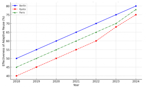
Instead of viewing heritage conservation as a restriction on development, this study advocates for adaptive reuse policies that allow historic buildings to serve contemporary functions while preserving their architectural integrity. Many cities, including Berlin and Kyoto, have successfully converted historic structures into cultural centers, boutique hotels, academic institutions, and mixed-use spaces, generating economic and social benefits without compromising historical authenticity, as shown in Figure 9 and Table 10.
Figure 9. Effectiveness of adaptive reuse strategies in heritage cities
Table 10. Successful adaptive reuse models from international heritage cities
|
City |
Adaptive Reuse Model |
Key Benefits |
|
Berlin |
Industrial buildings are repurposed into cultural and creative hubs. |
Revitalization of abandoned industrial areas; attraction of creative industries. |
|
Kyoto |
Traditional Machiya townhouses were converted into boutique hotels and restaurants. |
Preservation of traditional architectural identity while supporting local businesses. |
|
Istanbul |
Historic Ottoman-era buildings were transformed into museums and heritage centers. |
Enhancement of cultural tourism and education; reinforcement of historical narratives. |
|
Paris |
Old railway stations were converted into exhibition spaces and public libraries. |
Reintegration of heritage sites into modern urban life; increased public accessibility. |
|
Cairo |
Colonial-era buildings adapted for mixed-use developments, blending commerce and heritage. |
Sustained economic use of historic structures; improved urban aesthetics and functionality. |
Several historic buildings in Karbala remain underutilized or abandoned, increasing their risk of deterioration or demolition. Property owners can be encouraged to preserve and repurpose these structures by implementing adaptive reuse incentive programs. Such incentives may include tax reductions, restoration grants, or public-private partnerships that support heritage-based business models. Additionally, architectural competitions and academic collaborations can foster innovative design solutions that blend historical preservation with contemporary urban needs.
7.5 Enhancing community engagement and public awareness
The findings from this study confirm that a lack of public participation in urban planning has contributed to heritage site neglect and policy inefficiencies. The survey results indicate that 60% of respondents feel excluded from decision-making, suggesting that existing governance structures do not facilitate adequate civic engagement. Public participation mechanisms must be institutionalized within Karbala’s urban heritage management policies to address this.
First, Local Heritage Councils should be established within each conservation district, consisting of community representatives, architects, business owners, and religious leaders. These councils can provide localized oversight of urban development, ensuring that heritage conservation aligns with community priorities. A Public Awareness Campaign on Heritage Conservation should also be launched, featuring heritage education programs, urban storytelling workshops, and interactive mobile applications that inform residents about Karbala’s architectural history and cultural significance.
Furthermore, economic incentives for community-led conservation initiatives should be introduced, encouraging residents to participate in heritage site maintenance, guided tours, and sustainable tourism enterprises. This approach has proven effective in Moroccan and Italian heritage cities, where civic engagement has strengthened long-term urban preservation efforts.
7.6 Conclusion: Moving toward a sustainable heritage conservation model
The recommendations outlined in this section provide a comprehensive roadmap for integrating heritage conservation with modern urban planning in Karbala. By implementing institutional reforms, digital governance tools, regulatory zoning policies, adaptive reuse incentives, and public engagement strategies, Karbala can develop a sustainable and technologically advanced heritage management system. These efforts will protect the city’s historic identity and create economic, cultural, and urban innovation opportunities.
Moving forward, collaboration between government agencies, academic institutions, technology firms, and local communities will be essential in translating these policy proposals into actionable urban conservation strategies. Karbala has the potential to set a national precedent for integrating digital urban planning with cultural heritage preservation, safeguarding its rich historical legacy for future generations.
[1] Farhan, S.L., Attia, H.N., Rahim, L.A.L., Alobaydi, D. (2025). The role of temporary architecture in preserving intangible heritage during the Arbaeen pilgrimage in Holy Karbala: A case study. Buildings, 15(11): 1787. https://doi.org/10.3390/buildings15111787
[2] Ebraheem, A.K., Farhan, S.L., Shok, M.E., Hasan, S.A., et al. (2025). Preserving and enhancing cultural identity through virtual and augmented reality: The case of Karbala. International Journal of Sustainable Development and Planning, 20(4): 1457-1468. https://doi.org/10.18280/ijsdp.200409
[3] Farhan, S.L., Hasan, S.A., Rahim, L.A.L., Ebraheem, A.K., et al. (2025). Balancing heritage preservation and sustainable development in historic cities: A case study of Old Najaf in the context of global best practices. International Journal of Sustainable Development and Planning, 20(3): 1041-1051. https://doi.org/10.18280/ijsdp.200311
[4] Farhan, S.L., Merie, U.A.A.K., Nasar, Z. (2024). Revitalizing historic city center a comparative methodology of current approaches and alternatives. Journal of Cultural Heritage Management and Sustainable Development. https://doi.org/10.1108/JCHMSD-08-2022-0148
[5] Basee, D.H., Hmoud, S.M., Abdulla, Z.R. (2024). The impact of the morphological change of urban spaces in shaping the new microclimate: A case study in Karbala, Iraq. Ain Shams Engineering Journal, 15(3): 102463. https://doi.org/10.1016/j.asej.2023.102463
[6] Azeez, Z.A. (2021). The impact of destination image on tourist behavior: Karbala as a case study. International Journal of Sustainable Development and Planning, 16(7):1287-1298. https://doi.org/10.18280/ijsdp.160709
[7] Abbas, M.K., Naji, Z.M. (2023). Urban development of bayn Al-Haramayn zone based on 25-year estimation of Al-Arbaeen crowd density. E3S Web of Conferences, 427: 04013. https://doi.org/10.1051/e3sconf/202342704013
[8] Neamah, Z.K., Al-Busaltan, S., Al-Jwahery, Z. (2017). Developing a relationship between land use and parking demand for the center of the holy city of Karbala. Journal of Babylon University/Engineering Sciences, 25(5): 1652-1659. https://www.researchgate.net/publication/332131335.
[9] Khalaf, R.W. (2020). Cultural heritage reconstruction after armed conflict: Continuity, change, and sustainability. The Historic Environment: Policy & Practice, 11(1): 4-20. https://doi.org/10.1080/17567505.2019.1605709
[10] Bogacz-Wojtanowska, E., Góral, A. (2018). Networks or structures? Organizing cultural routes around heritage values. Case studies from Poland. Humanistic Management Journal, 3(2): 253-277. https://doi.org/10.1007/s41463-018-0042-1
[11] Kostešić, I., Vukić, J., Vukić, F. (2019). A comprehensive approach to urban heritage regeneration. In Cultural Urban Heritage: Development, Learning and Landscape Strategies. Springer, Cham, pp. 65-76. https://doi.org/10.1007/978-3-030-10612-6_6
[12] Xiao, W., Mills, J., Guidi, G., Rodríguez-Gonzálvez, P., et al. (2018). Geoinformatics for the conservation and promotion of cultural heritage in support of the UN Sustainable Development Goals. ISPRS Journal of Photogrammetry and Remote Sensing, 142: 389-406. https://doi.org/10.1016/j.isprsjprs.2018.01.001
[13] Allawi, A.H. (2022). Towards smart trends for tourism development and its role in the place sustainability-Karbala region, a case study. International Journal of Sustainable Development and Planning, 17(3): 931-939. https://doi.org/10.18280/ijsdp.170323
[14] Swensen, G., Jerpåsen, G.B., Sæter, O., Tveit, M.S. (2013). Capturing the intangible and tangible aspects of heritage: Personal versus official perspectives in cultural heritage management. Landscape Research, 38(2): 203-221. https://doi.org/10.1080/01426397.2011.642346
[15] Lei, H., Zhou, Y. (2022). Conducting heritage tourism-led urban renewal in Chinese historical and cultural urban spaces: A case study of Datong. Land, 11(12): 2122. https://doi.org/10.3390/land11122122
[16] Selim, G., Farhan, S.L. (2024). Reactivating voices of the youth in safeguarding cultural heritage in Iraq: The challenges and tools. Journal of Social Archaeology, 24(1): 58-78. https://doi.org/10.1177/14696053231224037
[17] Farhan, S.L.,Nasar, Z.A. (2020). Urban identity in the holy cities of Iraq: Analysis of architectural design trends in the city of Karbala. Journal of Urban Regeneration & Renewal, 14(2): 210-222. https://www.ingentaconnect.com/content/hsp/jurr/2020/00000014/00000002/art00008.
[18] Mahmood, T.M. (2024). The role of religious tourism projects in reducing unemployment in Holy Karbala (A case study of some sections of the Holy Hussein Shrine). International Journal of Tourism and Hospitality Management, 4(1): 55-62. https://doi.org/10.55640/ijthm-04-01-03
[19] Ameen, R.F.M., Shalal, S.S., Almayyahi, S.J.K. (2023). The effect of urban form factors and social sustainability on the shaping of traditional religious cities: An Iraqi case study. In 5th International Conference on Engineering Sciences-ICES21, Karbala, Iraq, pp. 060001. https://doi.org/10.1063/5.0131677
[20] Al-Najim, K.K., Abdul, A. (2024). The impact of tourism sustainability on the preservation of the urban heritage of ancient cities (Karbala city as a model). Gharee for Economics & Administration Sciences, 20: 1083-1108. https://doi.org/10.36325/ghjec.v20i00.16992
[21] Hyder, S.A. (2006). Reliving Karbala: Martyrdom in South Asian Memory. Oxford University Press.
[22] Sultan, A.R., Al-Thahab, A.A. (2023). Maintaining identity of the built environments of religious cities: Impact of expansions at the historic Karbala, Iraq. ISVS e-Journal, 10(8): 265-288. https://doi.org/10.61275/ISVSej-2023-10-08-19
[23] Raeda, A.D., Asadi, S. (2020). Strategic urban planning of religious cities: The case study of Karbala city in Iraq. Вестник МГСУ, 15(8): 1081-1089. https://doi.org/10.22227/1997-0935.2020.8.1081-1089