Nora Wahid Salem*![]() | Rana Mazin Mahdi
| Rana Mazin Mahdi![]()
© 2025 The authors. This article is published by IIETA and is licensed under the CC BY 4.0 license (http://creativecommons.org/licenses/by/4.0/).
OPEN ACCESS
Urban universities play a strategic role in reshaping their surrounding urban environments by driving physical, economic, and social transformations. This study aims to analyze the impact of the University of Technology in Baghdad on accelerating urban transformation, with a specific focus on the physical, economic, and social dimensions. The research adopts a multi-method approach that includes spatial syntax analysis, the Mixed Use Index (MXI), and the space matrix, alongside qualitative assessments, to track changes in the urban fabric from 1973 to 2024. The findings reveal significant spatial restructuring, characterized by increased urban density, expansion of mixed-use development, and improved spatial connectivity due to student activity and campus permeability. Patterns of local integration indicate notable social transformations within the urban network, supported by field interviews with local residents and shop owners. This study highlights the strategic role of urban universities in driving multidimensional urban transformation and offers a methodological framework for future research in similar contexts.
urban university, transformation, urban transformation, urban density, mixed use, full integration
Urban transformation refers to the comprehensive change that occurs within urban areas, encompassing social, economic, and physical dimensions. These transformations can be either positive or negative and may occur intentionally through strategic planning or unintentionally as a result of dynamic urban processes. In this context, transformation is not merely a physical alteration of space but a restructuring of urban functions, patterns, and relationships that define how people interact with their built environment [1].
This research focuses on urban transformation as a multidimensional phenomenon driven by various factors, including policy shifts, societal needs, and institutional activities. Two primary lenses are commonly employed to study urban transformation: (1) the analytical approach, which seeks to understand the underlying dynamics and their impact on urban morphology, function, and community needs; and (2) the normative approach, which advocates for intentional, systematic interventions to resolve urban challenges. Among the forces shaping urban transformation, universities—particularly those integrated within urban fabrics—have emerged as catalysts for change [2].
Urban universities are state-affiliated institutions that produce direct and indirect impacts on their surrounding environments. By enhancing connectivity, improving accessibility, and encouraging cultural and economic exchange, these institutions contribute to the restructuring of the urban landscape. This research aims to build a theoretical framework based on previous literature to evaluate how urban universities contribute to accelerating urban transformation. It seeks to answer the following question: How has the University of Technology in Baghdad influenced the physical, economic, and social dimensions of urban transformation in its surrounding area between 1973 and 2024?
Urban transformation refers to the comprehensive changes that occur within urban areas, encompassing physical, social, economic, and environmental dimensions. These transformations may be planned or unplanned, gradual or rapid, and often reflect shifts in land use, societal organization, and urban morphology. Transformation is not limited to visible spatial changes—it also represents a restructuring of how people interact with their environments and how urban functions evolve over time [1-3].
2.1 Urban transformation
Urban transformation operates along two major lines of inquiry:
These transformations are shaped by internal forces (e.g., demographic shifts, institutional changes) and external pressures (e.g., globalization, climate change). In this context, universities—particularly urban universities—emerge as institutional anchors that influence urban form and function [4-8].
2.2 Perspectives of urban transformation
Scholars commonly identify three core perspectives on transformation:
These perspectives help frame how transformation is initiated ("by"), where it occurs ("in"), and what its outcomes are ("of"). Effective governance models advocate for long-term, institutionalized agendas that anticipate and shape transformation over time.
The common goal across the perspectives and approaches of urban transformation research is to generate actionable knowledge to intervene in urban transformation processes and support radical change towards sustainable and resilient urban systems.
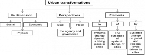
Urban universities are considered one of the agendas linked to the state; therefore, the impact of urban transformation resulting from them falls within the perspective of governance. Thus, the process of integrating universities into urban fabrics is carried out according to practical guidelines and directions. Figure 1 illustrates the dimensions, perspectives, and aspects of urban transformation.
Figure 1. Aspects of the terminological significance of the concept of urban transformation
Source: By the authors
2.3 Dimensions of urban transformation
2.3.1 Social dimension
The social dimension of urban transformation refers to a community-driven process that reshapes individuals’ living conditions, as well as their perceptions and aspirations regarding both tangible and intangible assets. Urban universities contribute to this dimension by actively engaging with social issues in their immediate environment, enhancing local living standards, and fostering initiatives that encourage collective community action [10]. The spatial design of university environments facilitates the creation of physical and functional connections between internal university activities and external urban life. These spatial characteristics help dissolve physical and social boundaries, thereby strengthening the university's integration with its surrounding context [11].
The presence of students in nearby neighborhoods often catalyzes the formation of new social and cultural relationships. This influence can be further amplified through participatory practices that promote dialogue, knowledge exchange, and collaboration between the university and local communities. Such engagement reflects a model of civic agency, wherein residents become active contributors to positive urban change by co-creating public value and participating in shared spaces. Public spaces, in particular, serve as the foundational infrastructure for community engagement. Within this model, the university and the city are viewed as reciprocal agents of transformation—each shaping, and being shaped by, the other [12].
2.3.2 Economic dimension
The economic and material impacts are considered the most important. One of the reasons for the economic dimension of urban transformation is the inability of universities to provide the required capacity for student housing on their own. Real estate agencies benefit from building new apartments to meet the needs of students, which in turn leads to changes in the physical structure of the built environment in the surrounding area. Therefore, the housing requirements for students, in addition to other facilities, encourage the growth of various forms that lead to increased urban density and a rise in the number of dual jobs (mixed-use jobs) [13]. One of the criteria for an urban university is that it responds to the community's needs and provides opportunities for low-income students to work while attending university. The mission of the urban university is to establish the educated use of urbanization to transform civic energy into economic change and development, thereby meeting the needs of its communities as industrial and commercial centers [14]. Urban universities provide a base of middle-class consumers, consisting of their employees and students, thereby offering human and financial resources in their surrounding urban environments. This has helped attract small businesses to the universities [10].
2.3.3 Physical dimension
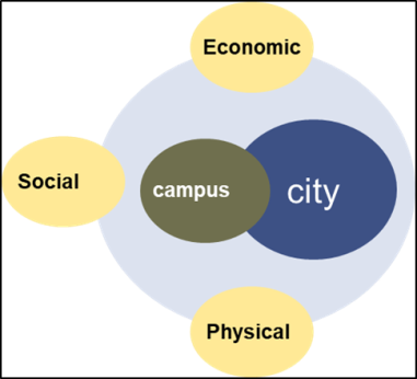
A change and transformation occur in the physical dimension of urban areas due to the presence of urban universities through the development and renewal mechanisms carried out by urban areas. Consequently, different architectural forms emerge that alter and transform the urban environment to respond to the university's requirements. One of these changes is the aggregation of urban density [13]. A study [15] illustrates how cities and urban areas acquire their density, where Hong Kong gains its density from tall buildings, Kinshasa from congestion, and Dhaka and Bogotá from residential coverage. The increase in urban density, or densification, has been explicitly identified as a sustainability goal. Therefore, the presence of universities embedded within urban structures helps to increase the aggregation of urban density, thereby achieving one of the sustainability goals. Many studies have revealed a range of secondary benefits from densification, including increased productivity, reduced public service costs, and enhanced social mobility. Figure 2 illustrates the dimensions of urban transformation.
Figure 2. Dimensions of urban transformation
The urban university is defined as buildings intertwined with the city, and this intertwining increases the interaction between the urban university and its surroundings; this interaction transforms urban spaces according to the logic of the university [16]. According to Čibik and Štěpánková [17], urban universities are important, multi-layered entities that are planted in city centers and influence spatial, social, economic, and visual functions. He also described urban universities as public places if they meet specific requirements for openness and accessibility.
As a result of the integration of the polycentric city model into the traditional fragmented model of parts and functions, some urban areas have become capable of responding to diversity and dynamism. This improvement is due to the evolution of user demand and expectations. These changes in the economy and society have moved the project's focus from being mainly about function to being more about space, resulting in new areas of research for how cities are organized and how their parts work together. The university is considered one of its most important components or strategic points, and thus urban universities are regarded as parties that contribute to adapting the processes of accelerating urban transformation and creating productive centers that align with contemporary design requirements [18].
Some studies have assumed that urban universities and their local surroundings somewhat influence each other. Planners believe that universities have a significant impact on their locations, whether they are in cities, neighborhoods, or other areas. Some studies have shown that size makes a difference on both sides of the relationship; universities, regardless of their size, are submerged in large capitals or major urban areas, while large universities completely dominate their urban environments if the urban area is small. Some universities also try to close their doors to the outside world to a greater or lesser extent, but complete closure is not feasible, and complete openness dissolves the university as a distinct unit. Therefore, universities have oscillated throughout their history on a continuous spectrum of openness and closure. A university may also be extremely diverse and fragmented within itself. Besides these factors, universities often suffer from a series of rapid expansions in all areas. Therefore, the urban restructuring imposed by the urban university in host areas consists of three components: transformations in economic activity, transformations in social and cultural activity, and transformations in the physical fabric [19]. Therefore, universities have emerged as active and important elements in accelerating the transformation process in urban areas through physical, social, and economic changes as a result of their response to the dynamics of the changing system. The cultural differences among students coming to universities from different cities have positively contributed to social life and created a tolerant democratic environment through settings that bring together residents and students, allowing the local population to get acquainted with different cultures [20].
3.1 Literature review
Urban universities are increasingly recognized as critical catalysts for urban change. Their spatial presence, institutional functions, and demographic dynamics often reshape surrounding neighborhoods in significant ways.
Several studies have analyzed how universities act as agents of urban transformation. For example, Mohammed and Ukai [13] emphasized the role of university campuses in promoting higher urban density and functional diversification. Their findings reveal that the expansion of campuses can lead to mixed-use development and infrastructure upgrades in nearby areas.
Fernández-Esquinas and Pinto [10] explored the economic impact of universities on their host cities, highlighting how they stimulate business innovation and attract investment through their consumer base of students and faculty. They argue that universities contribute to urban regeneration not only by occupying physical space but also by influencing socioeconomic patterns.
Other scholars, such as Hebbert [21] and Borsi and Schulte [22], have examined how universities integrate with the urban fabric through characteristics like spatial connectivity, permeability, and visual openness. Their studies classify campuses as either isolated "knowledge islands" or fully integrated "innovation districts," depending on their physical design and policy environment.
Domański [23] explored the dominance of academic institutions in shaping city branding and urban renewal, using Lodz, Poland, as a case study. His findings illustrate how universities help define the urban image of smaller cities and often dominate land use in their districts.
Čibik and Štěpánková [17] also noted the architectural and visual impact of universities in urban cores, identifying them as landmarks of transformation. They emphasized that open and accessible campuses foster more democratic and inclusive urban environments. The summary of these studies is presented in Table 1.
Table 1. Studies that address urban transformation in university-hosting areas
|
Vocabulary |
Dimension |
Study Title |
Researchers |
|
Urban density, mixed-use |
Physical |
University Campuses as Agents for Urban Change |
Mohammed and Ukai [13] |
|
Social participation |
Social |
– |
– |
|
Business innovation |
Economic |
The Role of Universities in Urban Regeneration |
Fernández-Esquinas and Pinto [10] |
|
Social integration |
Social |
– |
– |
|
Urban renewal |
Physical |
– |
– |
|
Spatial connectivity, diversity |
Physical |
The Campus and the City: A Design Revolution |
Hebbert [21] |
|
Permeability, cohesion with urban area |
Physical |
Typologies of Knowledge Universities |
Borsi and Schulte [22] |
|
Academic dominance |
Physical |
Role of Universities in City Renovation |
Domański [23] |
|
Mutual attraction strategy |
Economic |
– |
– |
These studies collectively reinforce the view that urban universities play a multifaceted role in reshaping urban space—not just through construction, but also through their capacity to stimulate interaction, mobility, and development in their vicinity.
3.2 Building the conceptual framework
Based on what was presented and discussed in previous studies, the research aimed to identify the most important variables and indicators related to the urban university and its ability to achieve the dimensions of urban transformation (social, physical, and economic) through the characteristics these universities possess. The conceptual framework for the research was constructed by referring to the most important variables that can be studied in the selected case study, as in Table 2.
Table 2. The theoretical framework for studying the most important variables and indicators of the dimensions of urban transformation in areas hosting urban universities
| Indicators | Variables | Vocabulary | Dimension | |
|
Distinguish expanded borders through porous or empty walls or plantations of trees |
Welcoming edges |
Spatial connectivity |
Characteristics of the urban university |
Physical |
|
The establishment of a number of gates along the University borders to be permeable |
||||
|
Reopening the streets and linking them with gate entrances to facilitate access to them |
||||
|
Integration of pedestrian and light vehicle traffic at street level |
||||
|
Development of retail stores along the border to serve the University and the metropolitan area |
||||
|
Connecting the boundaries and edges of the University with urban areas by creating buildings with heights consistent with the buildings of neighboring areas, and directing these buildings outwards in retail areas |
Reducing barriers | |||
| Construction of student housing units in the vicinity | ||||
| Connecting university buildings to create a fence | ||||
| Removing the boundaries between the University and the urban sector |
Permeability |
|||
| Visible and transparent facades of university buildings | ||||
| Construction of pedestrian bridges spanning the main streets | ||||
| Introducing large facades and arcades to the public domain |
Individual diversity |
|||
| Construction of buildings with sharp, defined and clear edges within the urban fabric | ||||
| The presence of more than one university in the same location |
The dominance of the academic character |
|||
| The size of the University compared to the urban area | ||||
| Increase the intensity of the built context |
Aggregation of urban density |
Characteristics of the urban area |
||
| Construction of high-rise buildings | ||||
| Connecting urban centers and places with university poles through a form of sustainable mobility |
Full integration |
|||
| Grouping of commercial activities in the streets surrounding the University | ||||
| Construction of buildings with a combination of single, dual and multiple functions | Mixed use | |||
| Revitalization of the housing stock in urban areas |
Urban renewal |
Mechanisms of the urban university |
||
| Reuse of existing buildings | ||||
| The expansion of universities and the establishment of movement corridors between scattered communities | ||||
| Students' involvement in public and community spaces |
Social integration |
Social |
||
| Increasing the student population | ||||
| Bringing small businesses |
Business innovation |
Economic |
||
| Bringing human and financial resources and providing a consumer base | ||||
| Indirect employment of the two communities (University and community) | ||||
| Bringing office buildings and providing opportunities for students while studying | ||||
In this study, urban transformation—comprising physical, social, and economic dimensions—is treated as a dependent variable, while the presence of the urban university serves as the independent variable. The primary objective is to evaluate the influence of urban universities, specifically the University of Technology in Baghdad, on the transformation of their surrounding urban fabric.
To achieve this objective, a mixed-methods approach was employed, integrating both qualitative and quantitative methodologies:
4.1 Qualitative phase
The initial phase adopted a qualitative approach to develop the conceptual framework and formulate the research hypothesis. This involved a comprehensive literature review, analysis of previous studies, and the identification of key indicators representing the characteristics of urban universities. Additionally, the features of the University of Technology were assessed through a descriptive plan analysis. In this method, characteristics were evaluated by assigning a binary value:
The average achievement levels were then calculated using the arithmetic mean to determine the degree to which the university exhibits each characteristic linked to urban transformation.
While spatial metrics such as integration and connectivity offer valuable tools for analyzing potential social interactions within urban space, they do not directly capture the lived experiences or perceptions of the community. Therefore, this study complemented spatial analysis with qualitative methods, including field surveys and in-depth interviews with local residents, shop owners, and students, to gain a deeper understanding of the social and economic dimensions of urban transformation. This integration of quantitative and qualitative approaches enriched the analysis and provided a more comprehensive perspective on the university’s impact on the surrounding urban fabric.
4.2 Quantitative phase
The second phase applied a quantitative approach to assess the spatial transformation of the urban area surrounding the university. This involved the use of multiple analytical tools, as outlined below:
Tool 1: Geographic Information Systems (GIS) and DepthMapX
Spatial analysis was conducted using a combination of ArcGIS and DepthMapX, a specialized software for space syntax analysis [24]. The process began by preparing base maps in ArcGIS [25], which were then transformed into axial maps using AutoCAD 2013. These maps represent kinetic and visual lines that structure pedestrian and vehicular movement.
The axial maps were subsequently imported into DepthMapX, which analyzes spatial networks by identifying relationships such as integration, connectivity, and adjacency across various scales—from individual buildings to entire city districts. This tool was used to calculate local and global integration values, allowing the identification of high, medium, and low integration zones. In this context, zones with high integration values are interpreted as areas of intense social interaction and movement, often representing primary thoroughfares and communal gathering spaces [26, 27].
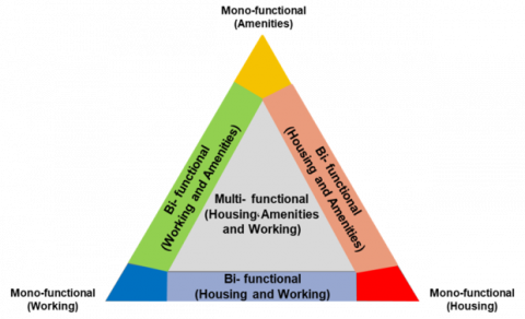
Tool 2: Mixed Use Index (MXI)
Mixed-use refers to the interconnection between different uses and activities [28], and it is considered one of the practical necessities for urban practice to illustrate the functions of urban fabric and distinguish between single-, dual-, and multi-functional urban blocks in a simplified manner [29], Buildings or urban blocks with a single purpose are classified as single-function. In this index, single-function blocks or buildings are classified either as residences, amenities, or workplaces. Shops, commercial establishments, entertainment centers, sports facilities, educational institutions, recreational facilities, and the building uses associated with them are all examples of amenities. As for industrial facilities, factories, workshops, farms, agricultural facilities, and the building uses associated with them, they all fall under workplace functions. As a result, a combination of two of these functions is called dual-function, while a combination of three functions is called multi-function. Activities are divided into three categories: essential, such as education, work, and shopping; optional, such as walking, stopping for coffee on the street, and people-watching; and social, which depends on the spontaneous presence of others and listening to them [28]. The values of theMXI are calculated based on the percentage of each function in the urban fabric using the building's floor area. MXI maps for the years 1973 and 2024 are created, and by comparing the resulting maps, urban changes and transformations in building uses can be visualized to assess the impact of the technological university on the physical and economic environment in the surrounding areas. The MXI is illustrated in Figure 3.
Figure 3. Mixed Use Index [30]
Tool 3: A space matrix
A multivariate index is used to quantitatively depict urban density based on urban form. In urban practice, the space matrix is still used as one of the recurring indicators to express the morphological structure in a simpler and more readable way [31]. In the space matrix, the Floor Space Index (FSI) is linked to the Ground Space Index (GSI) to obtain nine different classifications of urban density and form. Building density is classified in terms of height into low-rise, mid-rise, and high-rise buildings. On the other hand, building forms are classified into point type, strip type, and block type, and other measurements such as the open space ratio (OSRf) and the number of layers (floors) (L) can also be extracted from the spatial matrix. In this research, the values of the spatial matrix were calculated at the level of the urban fabric, including streets and paths, using the following equations.
$F S I F=\frac{F}{A f}$ (1)
where, F is the sum of the floors area in square meters and Af is the area of the urban fabric in square meters.
$G S I F=\frac{B}{A f}$ (2)
where, B is the area of the building in square meters and Af is the area of the urban fabric in square meters. The space matrix index is illustrated in Figure 4.
Figure 4. A space matrix [30]
4.3 Study area
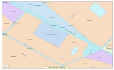
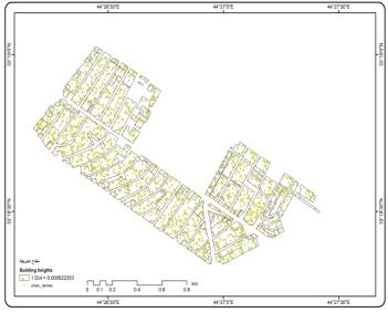
To obtain the most accurate data and answer inquiries regarding the research hypothesis, the case study was carefully selected. The urban area hosting the technological university, with an area of 1.5 km² and a perimeter of 5 km, was chosen due to its location within the main street network represented by the expressway (Mohammed Al-Qassem Street) and the Industrial Street, as shown in Figure 5. It is an Iraqi educational institution established in 1960 under the name of the Institute for the Preparation of Industrial Teachers, which was later renamed the Technological University in 1975. The case study involves examining the impact of the technological university on achieving urban transformation dimensions (the physical dimensions resulting from changes in urban area characteristics, represented by the aggregation of urban density, functional use transformation, and achieving full integration), in addition to the urban university characteristics represented by permeability and openness, spatial connectivity and interconnection, and individual diversity resulting from variations in shape and size and asymmetry, which leads to differences with the surrounding environment. This diversity can also stem from building materials [32], in addition to social and economic dimensions. These characteristics are studied from the period 1973 to the period 2024, where these characteristics are calculated for each period, and then a comparison and discussion of these results are conducted to reach the percentage of the university's impact on the surrounding area.
Figure 5. Location of the study area: The University of Technology in Baghdad
4.4 Materials and methods
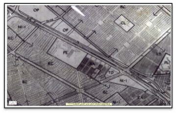
To assess the degree of urbanization resulting from the presence of the technological university, a combination of different methods was used to evaluate the morphology of urban areas and the street network in the study area. The Baghdad Municipality Directorate provided data on land use and building heights. This directorate conducted a survey named "General Development" in 1973, and maps and plans were taken for the purpose of studying, analyzing, and comparing them with the urban transformation that occurred in land use types. The predominant land use in 1973 was residential, along with commercial, educational, and service uses, as indicated by the attached Figures 6 and 7 and Tables 3 and 4.
Figure 6. Land uses according to development 1973
Source: Baghdad Municipal Directorate
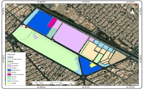
Figure 7. The land coverage rates for the year 2024
Source: Researchers based on the ARCGIS10.8 program
Table 3. Land uses according to development 1973
|
Type of Use |
Symbol |
Area (m2) |
Coverage Ratio |
|
Educational and cultural |
Pe |
268490 |
21% |
|
Residential (from 100 to 200) |
RA |
913972 |
72% |
|
Residential (from 400 to 800) |
RC |
|
|
|
Commercial |
CC |
18460 |
1.40% |
|
Garages and parking |
TD |
54421 |
4.30% |
Source: Baghdad Municipal Directorate
Table 4. The land coverage rates for the year 2024
|
Type of Use |
Symbol |
Area (m2) |
Coverage Ratio |
|
Educational and cultural |
Pe |
314944.00 |
22.4% |
|
Residential + Student housing |
R |
748251.00 |
61% |
|
Commercial |
CC |
84360.00 |
6% |
|
Garages and parking |
TD |
42180.00 |
3% |
Source: Researchers relying on the program ArcGIS 10.8
Due to limitations in accessible historical data and consistent land-use records, this study focuses on two benchmark years: 1973 (based on the General Development Survey conducted by the Baghdad Municipality) and 2024 (based on recent GIS analysis). Although intermediate data would enhance the understanding of transformation dynamics, the selected time points offer clear contrasts and allow for a focused analysis of long-term spatial changes influenced by the university’s presence.
4.5 Data validation and reliability
The reliability of spatial analysis tools such as GIS and DepthMapX depends on the accuracy of input data and the consistency of methodological procedures. In this study, base maps were sourced from officially published urban plans, verified cadastral data, and 2024 satellite imagery from Google Earth Pro. Axial maps used in DepthMapX were cross-checked with field observations and online mapping platforms to ensure proper alignment of movement lines, gate entrances, and building perimeters. Multiple iterations of spatial syntax analysis were conducted to confirm the stability of local and global integration values. For MXI and space matrix evaluations, land use and building height data were validated against recent municipality records and updated GIS shapefiles. This comprehensive cross-checking procedure enhances the methodological rigor and supports the validity of the findings.
The results of the data analysis to test the research hypotheses showed the following:
5.1 Physical dimensions
5.1.1 Mixed Use Index results
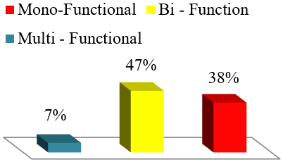
In 1973, the analysis of the MXI revealed that the urban fabric surrounding the University of Technology mainly consisted of urban blocks with single-use functions, including residential, commercial, educational, and cultural uses, it was found that single residential use was the dominant function in the urban area, accounting for 72% of total usage, followed by commercial, educational, and cultural uses. Even though single residential use was still the most common type, the results showed signs of a slow change in how urban areas are used, with more blocks starting to have two or more functions along with single residential use. The university's institutional influence has increased the diversity of urban uses and their spread throughout the region. The majority of mixed-use blocks were concentrated along the main streets surrounding the university, indicating the role of transportation hubs in attracting diverse activities. The percentage of multifunctional blocks reached approximately 7% of the total functions within the urban fabric, while dual-use blocks constituted about 47%. The remaining percentage was represented by single-use blocks, which varied between residential, educational, and commercial uses. In addition to the main streets and traffic lanes amounting to 8%, as shown in Table 5 and Figure 8.
Figure 8. Mixed Use Index statistics
Table 5. It shows the rates of single, dual, and multiple usage for the urban area surrounding the technological university for the year 2024
|
Mono-Functional Educational |
Mono-Functional Working |
Bi-Function (Residential-Commercial) |
Multi-Functional (Residential, Commercial, Industrial) |
Mono-Functional Housing |
|
17165.67 |
59663.96 |
168834.43 |
63465.82 |
72797.13 |
|
5657.03 |
7516.53 |
344902.09 |
15823.88 |
23881.80 |
|
197898.21 |
5436.07 |
12991.34 |
||
|
5570.83 |
||||
|
4717.87 |
||||
|
1613.74 |
||||
|
20% |
8% |
47% |
7% |
10% |
Source: The researcher based on the ArcGIS program
5.1.2 Space matrix index results
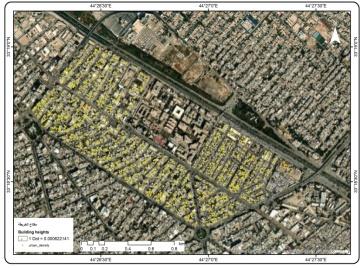
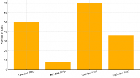
The urban density aggregation index indicated a significant transformation in building density within the area adjacent to the University of Technology, represented by a notable increase in building heights over the past decades. Low-rise buildings, often two floors high, dominated the urban character of the area in 1973, surrounded by green spaces and private residential gardens. In 2024, the area witnessed a functional and urban transformation, represented by residents and some investors redeveloping these buildings into vertical structures ranging from 5 to 6 stories high, with the aim of using them as residential apartments for students or as headquarters for investment companies. These buildings have clearly concentrated along the axes and streets surrounding the university campus, particularly on the streets with the highest number of entry gates, reflecting the university's impact as a major driver of transformation in urban morphology and functionality in the built environment. Figures 9 and 10 illustrate the spatial distribution of these transformations in urban heights within the studied area. However, Figures 11 and 12 illustrate the values of FSIf and GSIf specific to calculating urban density. Table 6 and Figure 13 show the number of high, low, and medium-height cells.
Figure 9. A diagram showing the representation of urban density for the year 2024
Source: Researcher based on the ArcGIS 10.8 program
Figure 10. A diagram showing the representation of urban density for the year 2024
Source: Researcher based on the ArcGIS 10.8 program
Table 6. Number of cells
|
Classification |
Number of Cells |
|
Low-rise Strip |
50 |
|
Mid-rise Strip |
8 |
|
Mid-rise Point |
70 |
|
High-rise Point |
36 |
Figure 11. A graph showing the percentage FSIf values for calculating urban density for the year 2024
Figure 12. A graph showing the percentage GSIf values for calculating urban density for the year 2024
Figure 13. Building height distribution in 2024 using space matrix classification (low-rise, mid-rise, and high-rise configurations)
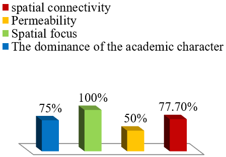
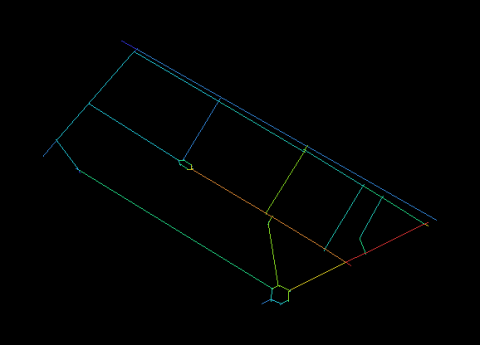
Regarding the physical urban dimension of the university, the technological university demonstrated a high level of spatial connectivity at 77.7%, due to the opening of seven entrances and the integration of pedestrian traffic with vehicle traffic, especially on side streets. The central location of the university contributed to achieving a spatial concentration of 100%, while the presence of other academic institutions, such as the University of Uruk, helped raise the academic dominance index to 75%. Despite the presence of physical boundaries such as walls, spatial permeability reached 50%. However, the irregular urban organization of the university buildings and the existence of several entrances leading to the adjacent streets have contributed to enhancing accessibility and visual and functional connectivity with the urban surroundings. Figures 14 and 15 illustrate the field analysis of the location of the technological university and its connection with the surrounding environment. Figure 16 presents percentage statistics that describe the characteristics of the University of Technology.
Figure 14. The diagram illustrates how the main and secondary streets connect to the technological university
Source: The researchers used ArcGIS 10.8 software to create this diagram
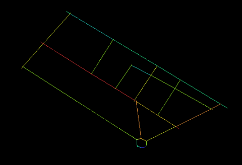
Figure 15. A diagram showing the number of gates and internal traffic corridors and their connection to the main streets
Source: Researchers based on ArcGIS 10.8 software
Figure 16. Percentage statistics for the characteristics of the University of Technology
5.2 Economic dimension results
The results of the field survey and land use analysis in the area surrounding the technological university showed a clear pattern of commercial uses associated with university activities. Office uses predominated within commercial functions, represented by photocopying and printing offices, in addition to offices providing technological and informational services. Other commercial functions with recreational and service-oriented characteristics, such as restaurants and cafes, also emerged, and these activities were notably concentrated along the main streets surrounding the university, as shown in Figure 17.
Figure 17. The locations of office and technology-related jobs
As for the student formation index, its results were manifested in the establishment of vertical residential complexes dedicated to housing students, which were distributed closely within the urban fabric of the area, especially at a distance near the university campus. These complexes are characterized by mixed-use, where the ground floor typically hosts commercial functions of an office or recreational nature. This architectural style has contributed to enhancing pedestrian movement within the area, leading to the activation of public spaces and boosting commercial development in the immediate vicinity of the university.
5.3 Social dimensions results
The social dimension is linked to the local integration and connectivity index, which are important urban indicators that contribute to enhancing attractiveness and community interaction within the urban fabric [33, 34]. To study this aspect, maps showing local and global integration were used to look at how the street network's integration levels changed from 1973 to 2024, which helped to understand the social changes caused by the creation and growth of the technological university.
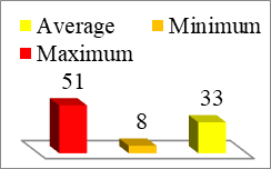
The results of the spatial analysis showed that the highest degree of local integration reached 287 in 2024, as shown in Figures 18, 19, and Table 7, concentrated in the streets surrounding the university, particularly in areas with the highest number of campus entry gates. This indicates that the university's expansion and the reorganization of its entrances have contributed to increasing openness and communication with the surrounding community.
Table 7. Local and global integration values for 1973 and 2024
|
Local Integration 2024 |
Global Integration 2024 |
||
|
Value |
Attribute |
Value |
Attribute |
|
Average |
171 |
Average |
39 |
|
Minimum |
5 |
Minimum |
25 |
|
Maximum |
287 |
Maximum |
59 |
|
Local Integration 1973 |
Global Integration 1973 |
||
|
Value |
Attribute |
Value |
Attribute |
|
Average |
119 |
Average |
33 |
|
Minimum |
8 |
Minimum |
8 |
|
Maximum |
189 |
Maximum |
51 |
Figure 18. Global and local integration statistics for 1973 and 2024
Figure 19. Global and local integration zones for 1973 and 2024
Additionally, the information gathered from personal interviews with local residents and shop owners backed this finding, as most people said that the university's growth and the rise in student numbers have led to more social interactions, both in business and everyday relationships between residents and students.
As for the results of the field survey, which included a sample of university students and residents of the area, it showed that more than 68% of the participants believe that the university has positively contributed to enhancing the sense of belonging and community interaction. This has been achieved through the use of public spaces and shared commercial shops, as well as the role played by open corridors and new gates in facilitating daily communication.
Accordingly, it can be said that the spatial and planning improvements around the technological university were not limited to achieving physical integration but also raised the level of social integration between the components of the university community and the local community, making the university one of the main drivers in reshaping social relations within the urban fabric. Figure 20 illustrates the local and global integration index over time (1973–2024).
Figure 20. Local and global integration index over time (1973–2024), illustrating a notable rise in spatial integration due to improved permeability and campus access
While this study provides valuable insights into the role of urban universities in driving spatial, economic and social transformation, several limitations should be acknowledged:
The analysis is based on two fixed time points—1973 and 2024—chosen due to the availability of reliable land use and spatial data. However, the absence of intermediate data from the 1980s, 1990s, or early 2000s limits the ability to understand how transformation unfolded over time. Without this temporal granularity, it is difficult to identify whether changes occurred gradually, abruptly, or in distinct phases.
This research is based on a single case study—the University of Technology in Baghdad. While it provides detailed and context-rich insights, the findings may not be directly transferable to other cities or university environments, especially those with different planning regulations, governance structures, or urban densities. Comparative studies across multiple cities would help validate and generalize the observed patterns.
Some historical land use records and urban plans, particularly from earlier decades, were limited in detail and required interpretation. While care was taken to ensure consistency in analysis, certain spatial classifications and extrapolations may introduce subjectivity into the results.
Despite these limitations, the study offers a robust framework for understanding how urban universities can act as drivers of urban transformation.
The research results showed that the technological university has played a pivotal role in reshaping the surrounding urban fabric through multiple dimensions, represented in spatial, functional, social, and economic transformations.
Based on these results, the following is recommended:
Universities, especially those located in central urban areas, should be included in urban development plans as active elements in restructuring urban spaces and achieving functional integration.
It is important to enhance cooperation between universities and municipalities to coordinate projects that serve both parties, such as improving infrastructure, revitalizing public spaces, and supporting community services.
We can enhance the permeability of the urban university and fortify the connections between the university and the local community by lowering physical barriers, expanding the number of entrances, and creating shared pathways.
Supporting policies that permit mixed-use developments around universities creates vibrant urban environments that can meet the needs of both students and the local community.
The university can organize cultural and service initiatives that integrate students with local residents, which enhances belonging and contributes to building a cohesive urban community.
It is recommended to repeat this type of study in other urban university locations within and outside Iraq to extract common patterns and identify best practices that contribute to achieving a sustainable urban transformation led by universities.
While these developments enhance functional complexity and connectivity, they also raise concerns about spatial equityand urban livability. The replacement of low-rise homes with investor-led multi-story apartments may marginalize long-term residents through increased rent and infrastructural strain. These potential externalities, though beyond the current dataset, warrant further study into whether such transformation processes benefit all segments of the community or disproportionately favor the university population and commercial investors.
The authors would like to express their sincere gratitude to the Department of Architectural Engineering at the University of Technology, Baghdad, for their academic and logistical support throughout this research. Special thanks are extended to the Baghdad Municipality Directorate for providing access to spatial and land use data necessary for the analysis. The constructive feedback from reviewers and colleagues is also gratefully acknowledged.
[1] Batty, M., Barros, J., Junior, S.A. (2006). Cities: Continuity, transformation and emergence. Complexity and co-evolution: Continuity and Change in Socio-Economic Systems, 2006: 61-76.
[2] Abbas, S.S., Tarq, A.T. (2005). Transformation in urban design. Iraqi Journal of Architecture and Planning, 2(1): 388. https://doi.org/10.36041/iqjap.v2i1.388
[3] Al-Hinkawi, W.S., Haki, M.H. (2009). Formal transformation in urban context analytical study to the formal transformation in urban context by using the remote sensing. Iraqi Journal of Architecture and Planning, 5(1&2&3): 384. https://doi.org/10.36041/iqjap.v5i1&2&3.384
[4] Das, R., Nag, S., Mitra, K. (2020). Urban transformations of residential settlements in colonial towns: Case study of Chandernagore and Serampore. In Perception, Design and Ecology of the Built Environment: A Focus on the Global South. Springer, Cham. https://doi.org/10.1007/978-3-030-25879-5_2
[5] Kemec, A., Senol, P., Yalcin, O. (2019). Practice of urban transformation in terms of financial and economic cycles: A case study of Isparta in Turkey. Materials Science and Engineering, 471(9): 092050. https://doi.org/10.1088/1757-899X/471/9/092050
[6] Hölscher, K., Wittmayer, J.M., Avelino, F., Giezen, M. (2019). Opening up the transition arena: An analysis of (dis) empowerment of civil society actors in transition management in cities. Technological Forecasting and Social Change, 145: 176-185. https://doi.org/10.1016/j.techfore.2017.05.004
[7] Hölscher, K., Wittmayer, J.M., Loorbach, D. (2018). Transition versus transformation: What’s the difference? Environmental Innovation and Societal Transitions, 27: 1-3. https://doi.org/10.1016/j.eist.2017.10.007
[8] Hölscher, K., Frantzeskaki, N. (2021). Perspectives on urban transformation research: Transformations in, of, and by cities. Urban Transformations, 3: 1-14. https://doi.org/10.1186/s42854-021-00019-z
[9] Kabisch, S., Koch, F., Gawel, E., Haase, A., Knapp, S., et al. (2018). Urban transformations. In Sustainable Urban Development Through Resource Efficiency, Quality of Life and Resilience. Cham: Springer (Future City Ser, v. 10). https://ebookcentral.proquest.com/lib/gbv/detail.action.
[10] Fernández-Esquinas, M., Pinto, H. (2014). The role of universities in urban regeneration: Reframing the analytical approach. European Planning Studies, 22(7): 1462-1483. https://doi.org/10.1080/09654313.2013.791967
[11] Mahdi, R.M., Aboud, A.H. (2021). Underground housing formation strategies. In Journal of Physics: Conference Series, 1773: 012033. https://doi.org/10.1088/1742-6596/1773/1/012033
[12] Sara, R., Jones, M. (2018). The university as agent of change in the city: Co-creation of live community architecture. Archnet-IJAR, 12(1): 326-337. https://doi.org/10.26687/archnet-ijar.v12i1.1286
[13] Mohammed, A.M., Ukai, T. (2022). University campuses as agents for urban change. Environmental & Socio-Economic Studies, 10(1): 22-37. https://doi.org/10.2478/environ-2022-0003
[14] Diner, S.J. (2017). Universities and Their Cities: Urban Higher Education in America. JHU Press.
[15] Angel, S., Lamson-Hall, P., Blanco, Z.G. (2021). Anatomy of density: Measurable factors that constitute urban density. Buildings & Cities, 2(1): 264-282. https://doi.org/10.5334/bc.91
[16] Goloshubin, V., Pavlova, V. (2022). Campus: University or a modern urban structure? Architecture, 10(3): 913-922. https://doi.org/10.13189/cea.2022.100313
[17] Čibik, M., Štěpánková, R. (2020). Exploring university campuses as urban development boosters and design flagships in urban landscapes. Journal of Interdisciplinary Research, 10(2): 19. https://doi.org/10.33543/1002
[18] Marta, C., Emilio, F., Pilar, V.M. (2022). Univercity. The university as a metaphor for the city. processes, methods, and tools for contemporary design. In Transforming our World through Universal Design for Human Development. IOS Press, pp. 581-588. https://doi.org/10.3233/SHTI220890
[19] Wusten, H. (Ed.). (1998). The Urban University and Its Identity: Roots, Location, Roles. Amsterdam: Springer Netherlands. https://doi.org/10.1007/978-94-011-5184-9
[20] Келесбаев, Д. Н., Бекебаева, М. О., Тайжанов, Л.Т., Таяуова, Г.Ж. (2022). Изменение роли университетов в социально-экономических трансформационных процессах городов. Вестник Университета «Туран», 4: 288-299. https://doi.org/10.46914/1562-2959-2022-1-4-288-299
[21] Hebbert, M. (2018). The campus and the city: A design revolution explained. Journal of Urban Design, 23(6): 883-897. https://doi.org/10.1080/13574809.2018.1518710
[22] Borsi, K., Schulte, C. (2018). Universities and the City: From islands of knowledge to districts of innovation. The Journal of Architecture, 23(7-8): 1143-1180. https://doi.org/10.1080/13602365.2018.1514524
[23] Domański, T. (2017). Role of universities in city renovation and in shaping its international brand: A case study of the Polish city of Lodz. International Studies: Interdisciplinary Political and Cultural Journal (IS), 19(1): 103-128. https://doi.org/10.1515/ipcj-2017-0007
[24] Mohammed, N., Mazin, R. (2025). Enhancing sensitive urban densification through infill development: A GIS analysis of vitality and integration in Jawaher Dijla residential compound, Iraq. In AIP Conference Proceedings, Cincinnati, USA, p. 040068. https://doi.org/10.1063/5.0256153
[25] Tahmi, S. (2023). Program user guide ARCGIS. https://www.scribd.com/document/730582881/ARCGIS.
[26] Syntax, U.S. (2022). DepthMapX Space Syntax–Online Training Platform. https://www.spacesyntax.online/software-and-manuals/depthmap/.
[27] DD Team. (2017). DepthMapX: Visual and spatial network analysis software. The Bartlett School of Architecture—UCL—University College London. https://www.ucl.ac.uk/bartlett/architecture/research/space-syntax/depthmapx.
[28] Al-Dairy, F.L., Al-Saaidy, H.J.E. (2024). Urban chaos: A descriptive study of functional overlap using the city of Babylon (Medhatiya) as a model. Ain Shams Engineering Journal, 15(4): 102607. https://doi.org/10.1016/j.asej.2023.102607
[29] Berghauser Pont, M., Haupt, P.A. (2023). Spacematrix: Space, density and urban form. https://discovery.upc.edu/iii/encore/record/C__Rb1440045?lang=cat.
[30] Mohammed, A.M., Ukai, T., Hall, M.W. (2022). University campuses’ role in accelerating the natural urban transformation process. Bulletin of Geography. Socio-Economic Series, 58: 75-96. https://doi.org/10.12775/bgss-2022-0035
[31] Forsyth, R. (2003). Measuring density: Working definitions for residential density and building density, density brief, 8 2003. Design Center for American Urban Landscape, University of Minoesota.
[32] Rasheed, K.G., Mahdi, R.M. (2022). Formal activation through complexity characteristic. Iraqi Journal of Architecture and Planning, 21(2): 76-94. https://doi.org/10.36041/iqjap.2022.133311.1036
[33] Nasser, W.W., Mahdi, R.M. (2023). The role of connectivity and integration in cultivating attractive values: A space syntax study of al-amal housing project, Basra. International Journal of Sustainable Development & Planning, 18(9): 2847-2852. https://doi.org/10.18280/ijsdp.180923
[34] Mohammed, N., Mazin, R. (2025). Strategies for urban densification in the city of Baghdad-Kadhimiya, A case study. In AIP Conference Proceedings, Cincinnati, USA, p. 040076. https://doi.org/10.1063/5.0256421