Shahad Abdul Hussein Aldhahir![]() | Husam Sachit Senah
| Husam Sachit Senah![]() | Adil Mahdi Jabbar*
| Adil Mahdi Jabbar*![]()
© 2025 The authors. This article is published by IIETA and is licensed under the CC BY 4.0 license (http://creativecommons.org/licenses/by/4.0/).
OPEN ACCESS
The research uses Kut City as a model to examine urban resilience strategies in designing public spaces along riverbanks in medium-sized cities. It aims to promote sustainability, respond to climate change, and support biodiversity by creating flexible and adaptable public spaces. It also seeks to stimulate economic and recreational activities along the banks of the Tigris River, enhancing the city's quality of life, which can be generalized to other medium-sized cities. Integrating urban resilience with public space design to provide sustainable environments resilient to environmental and social challenges is also an area of exploration. The offered model improves urban resilience and sustainable expansion by developing adaptable spaces for climate change. The model can facilitate societal engagement in public spaces, donating to sustainable urban maturation by developing biodiversity and social-economic sustainability. The results revealed the significance of collaboration among the public, private, and local sectors in investing in green infrastructure projects and enriching local environmental sustainability. They also confirmed that enhancing permeability between urban spaces and river banks improves social relations and contributes to devising more sustainable urban environments. The study also recommends adopting flexible urban planning policies to be compatible with future climate change, focusing on allocating land for multifunctional green spaces, enhancing public transportation networks to facilitate access to river banks and safe areas, and improving environmental permeability through green passages that connect river banks to the city center, which enhance the overall comfort for residents and reducing temperatures.
urban resilience, sustainability, river banks, medium-sized cities, Kut City
Cities, particularly medium-sized cities, face significant environmental, social, and financial challenges due to climate change, population growth, and the depletion of finite natural resources [1]. Managing these matters needs creative strategies to improve urban resilience and boost sustainability [2]. Riverbanks provide essential chances to transform them into multifunctional spaces that deal with urban development and environmental conservation simultaneously [3].
Urban resilience is the ability of the city to adapt to and recover from social, geo-environmental, or economic shocks or stresses [4]. The significance of urban resilience and associated problems has been the subject of attentive studies for a long time. These include alluvion, climate change, and urban developments that impact life quality. Some of these studies focused on merging design strategies to adapt to environmental changes and eliminate natural hazards along riverbanks [5].
O'Donnell et al. [6] and Chan et al. [7] have emphasized the integration of engineering and natural techniques to enhance riverbank resilience. Their studies have concentrated on improving ecosystems by encouraging sustainable agriculture and using native plants, as well as including green infrastructure, rain gardens, and natural channels to develop adaptation to environmental changes and reduce hydrological hazards.
On the other hand, Ebrahimian et al. [8] addressed the significance of collaboration between residents and urban administrations in enriching urban resilience, emphasizing the pivotal role of digital devices in flood monitoring and more efficient water resource management. That integrated approach contributes to developing sustainable keys based on effective society participation, enhancing the adaptive ability of riverine areas in the face of environmental and climate challenges.
The most notable aspects of urban resilience along river banks that need more explanation include:
1) Modifying Urban Resilience Approaches for Medium-Sized Cities: Most urban resilience investigations concentrate on large cities or cities influenced by natural disasters, such as flooding in specific areas. For medium-sized cities like Kut, there is a lack of studies on adapting resilience approaches to serve these cities' challenges, such as limited facilities and financial resources [9].
2) Relations between urban design and local ecosystems: despite several studies addressing green facilities and ecosystems [10, 11]. Most other studies have not discussed integrating conventional urban patterns that may be part of a city's identity, such as Al Kut.
3) Social and economic challenges: There is a lack of studies that deal with the role of residents in developing and executing resilience strategies for riverine cities, specifically in medium-sized cities where social and economic challenges are more impactful [12, 13].
4) Integration of conventional and modern technologies: In some cases, modern digital technologies, such as smart water management systems, have not been integrated into the design of riverside public spaces, which is crucial for enhancing resilience in medium-sized cities [14, 15].
The significant role of green spaces in enhancing urban resilience cannot be neglected. However, a notable gap in implemented research still estimates the effect of such solutions, including rain gardens and permeable roofs, on flood hazard reduction in medium-sized cities like Kolkata [11, 16]. Most recent studies focus on large cities with more advanced capabilities, leaving medium-sized cities without the quantitative data needed to demonstrate the effectiveness of these interventions, particularly in their riverine settings [17]. Addressing this gap through field-based examinations could deliver invaluable insights into how green solutions enhance stormwater management and decrease flood effects [18]. That would enable the evolution of a more thorough application framework for creating sustainable and climate-resilient riverbanks.
Most available research focuses on applying urban resilience in large cities and neglects medium-sized ones [9-11, 16]. Therefore, this research focuses on applying urban resilience concepts and requirements in medium-sized cities and uses the city of Kut as a practical model, which can derive methods for developing urban policies that adapt to the future challenges facing such medium-sized cities.
This study examines Al-Kut as a case study for medium-sized cities, focusing on the potential for revitalizing the banks of the Tigris River following sustainable urban principles. It focuses on resilience approaches for public areas along riverbanks in medium-sized cities. The primary research question is: "How can sustainability and societal arrangement strategies be integrated into riverbank design to enhance urban resilience in Al-Kut?" The research will investigate sustainable design solutions such as green amenities, improved accessibility, and adaptable public spaces while emphasizing the role of economic and recreational activities along riverbanks in fostering local development and enhancing urban quality of life.
Additionally, it highlights the necessity for urban areas to respond to changes such as flooding and warming while promoting urbanization and protecting river ecosystems. The research supports resilient design for enhancing the tie between communities and their natural environments. It offers a concept for urban designers to change riverside areas into places that are green, multifunctional hubs, which can raise life quality and sustainability over time.
This research seeks to identify strategies to enhance urban resilience by creating public spaces adjacent to rivers in mid-sized cities while ensuring environmental sustainability, climate change mitigation, biodiversity conservation, and increased economic and recreational activities. The study used Kut City as a case for the implementation. It also attempted to design a comprehensive urban plan for the Tigris River banks in Kut that could be used in other mid-sized cities and consequently enhance urban resilience and sustainable developmental practices.
3.1 Urban resilience and riverbanks in medium-sized cities
Urban resilience is increasingly important in development, mainly in areas exposed to environmental change, like riverbanks. It shows the ability of a human system to respond to various shocks and still function, as well as be sustained over time [19]. Riverbanks in mid-sized cities serve as valuable urban and natural spaces that can enhance social interactions, economic activities, biodiversity, and water resource management for recreational purposes [20].
The modern study of cities focuses on four primary concepts as the explainers of how urban systems behave to shocks:
3.2 Urban resilience and green infrastructure: Towards sustainable and resilient environments
Urban resilience and green facilities are crucial for sustainable cities. They help in adaptation to environmental and social changes. Urban resilience affects a city's ability to rebound from impacts, maintaining its essential roles amid natural catastrophes and climate change while considering the environmental, social, economic, and infrastructural elements [25]. Green infrastructure comprises natural approaches in urban environments, such as gardens and green shelters, to improve ecosystem benefits like air quality and stormwater control [26]. These components also enhance biodiversity and public health. In medium-sized cities like Al Kut, combining green areas is paramount for resilience processes, which involves evaluating environmental hazards and operating green plans for water filtration and temperature regulation. Community engagement is crucial for developing public areas that meet residents' requirements. Generally, urban resilience processes can convert the Tigris River banks in Kut into adaptable natural spaces, improving urban life quality, social relations, regional economies, and cultural activities.
Medium-sized riverine cities are outstanding examples of studying urban resilience techniques, as they face equal environmental and social challenges. Examples include:
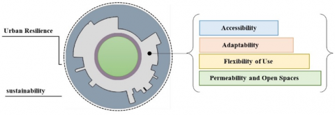
Figure 1 depicts the relationships between the urban resilience indicators. Each indicator connects to the others, illustrating how they contribute to a comprehensive urban resilience framework.
Figure 1. A flowchart represents the relationships between the urban resilience indicators based on the analysis
3.3 Applicable strategies on the banks of the Tigris River in Kut
Based on experiences from the mentioned cities, some methods can improve the Tigris River banks in Kut City:
Upon drawing inspiration from other medium-sized cities, an urban resilience model suitable for Kut can be developed, integrating natural heritage conservation with sustainable urban development along the banks of the Tigris River.
The research adopts a mixed approach, combining qualitative and quantitative methods to comprehend urban resilience systems and sustainable design. Kut City was chosen as a case study to analyze the development of public spaces along riverbanks. Data collection methods included field observations, a questionnaire for urban planning, sustainability, and hydrology professionals, an analysis of local development plans and legislation, and a study of land use changes and the distribution of green infrastructure.
The field observations include visiting the site and field inspection to assess physical characteristics and usage patterns. The survey included 109 people from different segments of society in the fields of engineering, urban planning, teachers, university lecturers, artists, painters and intellectuals. The questionnaire was designed according to a five-point Likert scale. The questionnaire was distributed electronically to the previously mentioned individuals in electronic groups. Individuals completed the questionnaire over a period of 21 days.
Analysis of local plans and legislation includes meetings with officials in government agencies concerned with planning and development to review the city's development plans and analyze them in accordance with applicable local laws. The land use and distribution of green infrastructure were studied based on the basic design of the city and the sectoral designs of the riverbank area, and the mechanism for distributing green areas according to environmental determinants, population ratios, and internationally approved standards.
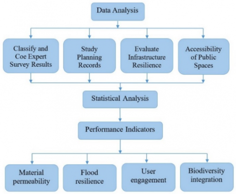
Data were analyzed by classifying and coding expert survey results, studying planning records, and evaluating the infrastructure resilience and accessibility of public spaces. Statistical analysis was applied to interpret survey results and environmental data. Performance indicators are also developed to measure the effectiveness of sustainable designs, such as material permeability, flood resilience, biodiversity integration, and user engagement, as illustrated in Figure 2.
The design was based on the sponge cities principles and urban resilience, testing the impact of different interventions on improving public space resilience. This methodology provides an integrated framework for studying and analyzing sustainable and resilient public space designs in medium-sized cities, focusing on the City of Kut as a model application.
Figure 2. A flowchart of the procedure for analyzing the data
5.1 Kut City overview
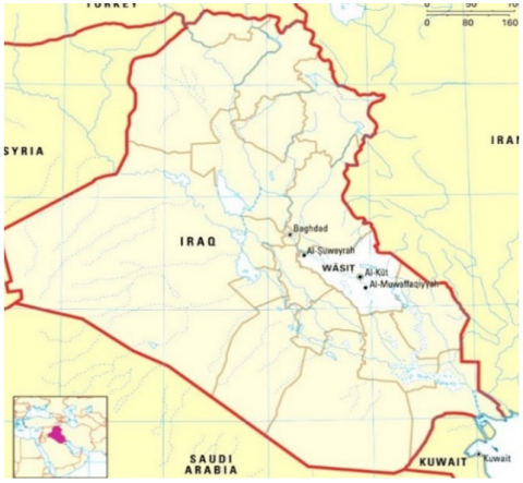
Kut is an Iraqi city that has historical and cultural significance. It takes its name "the citadel" or "fortress" due to the shape of the river surrounding it, giving natural immunity. The City was founded between 1100 and 1700 AD on the banks of the Tigris River. Its importance increased due to its strategic location connecting various regions of Iraq, making it an important commercial center and a transit hub between the north and south, in addition to serving as a border point during certain historical periods [29, 30]. The City's population in 2018 was approximately 389400, and the current population is approximately 477315 [31]. It is the administrative center of Wasit Governorate. It is located in central Iraq, 170 kilometers southeast of the capital, Baghdad, as shown in Figure 3. The coordinates of the location of the city of Kut on the world map are: 32.4903, 45.8292.
Figure 3. Iraq Map showing the location of Kut City [30]
The city has witnessed continued growth, particularly towards the north, to address housing ultimately from population growth. However, some planned areas were not ideal, causing the redesign and implementation of main streets such as Kut-Amara, Al-Kafaat, and Tammuz Corniche Streets. Pivotal developments, including the Teachers' Corniche, Kut Hotel, Sir William Mall, and Dijlah Hospital, are underway but have negatively affected street ability and the city's relationship to the Tigris River. Kut's location along the river offers natural attractiveness and a rich water resource, making it superior for sustainable development that honors local habits. Despite this, green areas along the riverbanks stay underutilized, leading to landscape degradation and a weakened river ecosystem. Urban growth has further separated the city from the river, threatening its formal nature and riverfront identity.
The areas along the Tigris River in Kut are attributed to imposing physical characteristics. These features make the riverbanks attractive to create surprising spaces such as walking pathways, seating spaces, and green areas, which can improve their natural attractiveness. Necessary comfort facilities such as bathrooms, lighting, and garbage removal can enhance visitor amenities. The river's nearness delivers opportunities for water activities, converting these public places into more attractive ones. Visitor demographics are variable, with families, travelers, and residents each having exceptional needs. Shared activities include walking, jogging, picnicking, and social gatherings, which change with the time of day and season, with mornings favored for exercise and evenings for socializing. Further, these shared places integrate adaptable elements, such as portable furniture and specified areas for markets and festivals. The community's participation in planning these activities is crucial to ensuring that the spirit and responsiveness to the demands of the residents are maintained.
5.2 Seasonal events influencing public space use along the Tigris River banks in Kut
The Tigris River in Kut is a good example of how public places can be used seasonally by different people. For instance, spring festivities like Nowruz Day bring people to the area who engage in leisure activities like walking and picnicking. This time also has moderate weather, which increases outdoor activities and thus the visitors. Barbecues and social gatherings are quite vibrant during the long summer evenings. Concerts and movie nights can be hosted in the public areas, making them more popular. These places are also more frequently used for water-related activities like kayaking, fishing, and other boating activities in the hot summer. There is an increase in people using public spaces and markets during the local harvest festivals in the fall season. Interacting with the green spaces is positively affected by the mild weather and outdoor activities. In winter, public spaces have a variety of events to celebrate the winter holidays like Christmas and New Year's Markets or light displays, which create a festive atmosphere.
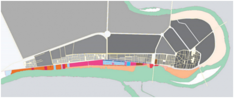
5.3 Spatial analysis of the riverfront to the city center of Kut
There is always a delicate balance between nature and urban development, which is evident in the spatial analysis of the riverfront periphery around the Kut City center. This careful design of these areas enhances the quality of life, which motivates civic engagement and other social interactions. The riverfront has the potential to develop into a lively center that will assist the residents and tourism while simultaneously adding value to the economy. Similarly, managing and safeguarding the riverfront is equally important for striking a balance between the ever-increasing urbanization and nature for the succeeding generations.
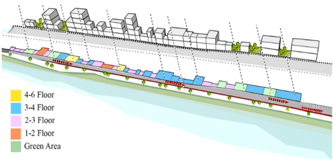
Figure 4. The proposed types of facilities that can be erected on the riverfront in Kut that meet the urban resilience requirements
Figure 4 illustrates the proposed types of facilities that can be erected on the riverfront in Kut that meet the urban resilience requirements and balance the environment surrounding the area.
5.4 Strengths and weaknesses of the riverfront in Kut City
The area is known for its recreational potential thanks to a set of natural attributes, including beauty and easy access; however, pollution and overcrowding are some challenges the site faces. For these reasons, it is necessary to implement effective strategies, such as promoting tourism and increasing local involvement in environmental preservation. Developing the region will depend largely on its local government, business, and non-profit organizations working together towards establishing green infrastructure that enhances the area's attraction.
The perspectives of 40 urban planners, architects, and environmental specialists were utilized in a survey aiming to improve urban resilience and environmental sustainability issues in Kut City. The majority have over five years of professional experience. The experts are affiliated with academic institutions, national organizations, municipalities, and consulting firms. The survey addresses challenges and opportunities related to the riverfront area, which, while beautiful, needs pollution and congestion reduction. Building sustainable tourism, community participation, and collaboration between public, private, and non-profit organizations pose additional crucial strategies. Utilizing riverfront areas as natural flood defenses, as well as marrying passive houses with native vegetation and biofiltration systems, are among the most important design strategies. The answers can help form a holistic approach towards making the city more resilient to climate change while focusing on creating a sustainable urban environment.
The questions focus on a set of indicators that contribute to enhancing urban resilience, which include:
Accessibility: Enhancing access to riverine spaces and public spaces to promote community employment and recreational activities.
Adaptability: Executing processes to help the city adapt to environmental and climate changes through flexible solutions.
Accessibility to open spaces: Creating public spaces to encourage social relations and cultural expression, maintaining community relations, and resilience.
Flexibility of Usage: Planning multi-functional spaces to adapt to the evolving demands of society, providing long-term sustainability.
Table 1 includes the main and secondary indicators adopted in the questionnaire.
The purpose was to collect data to support flexible, diverse, and inclusive strategies and develop innovative solutions to address current and future challenges. These strategies can improve the city's urban environment, increase its ability to adapt to ongoing changes, and enhance the sustainability and quality of society members' lives. Table 1 illustrates the main and secondary questions applied in the questionnaire.
Figure 5 illustrates the four main indicators identified as urban resilience that are considered in the survey.
Table 1. The main and secondary indicators adopted in the questionnaire
|
Main Indicator |
Secondary Indicators (Related to the Tigris River Bank in Kut) |
|
Urban Resilience Strategies |
The effectiveness of resilience strategies in facing the Tigris River floods. |
|
The role of green infrastructure in enhancing the resilience of the West Bank. |
|
|
Integration of resilience strategies with development plans for the West Bank in Kut. |
|
|
Flexible Urban Design Application |
Integrating flexible public spaces with the Tigris River ecosystem. |
|
Use of local materials in the design of flexible river spaces. |
|
|
The impact of local community participation in the design of the West Bank. |
|
|
Principles of Sustainable Urban Design |
Environmental impact of permeable surfaces and rain gardens on the bank. |
|
The role of native plants in promoting environmental sustainability. |
|
|
Integrating sustainable design with cultural activities such as hunting and celebrations. |
|
|
Impact of Design on Public River Activities |
Flexible design is focused on supporting local job opportunities. |
Figure 5. The four core indicators identified the urban resilience
6.1 Reliability analysis of questionnaire
The questionnaire included several types of questions, eight of which were selected to verify the reliability and applicability of the questionnaire items, as indicated in the Appendix. The answers to the eight questions involved five scales from 1 to 5 according to the Likert scale, with 1 representing low acceptance and 5 representing high acceptance. Table A1 in the Appendix illustrates the answers of the twenty-seven responders who participated in the questionnaire. The questionnaire questions were divided into two groups: odd and even; thus, two new variables were created, the first representing the average of the odd question scale and the second the average of the even question scale. Table A2 in the Appendix illustrates the odd and even values, where odd values are represented by the variable (x) and even values by (y). The correlation coefficient (r) between the two variables was calculated using Pearson's method, and the value of the correlation coefficient was 0.5004. Then the correlation coefficient was corrected using the Spearman-Brown equation, and the value of the reliability coefficient was 0.667, the reliability coefficient value was acceptable and statistically significant. This confirms the validity and reliability of the questionnaire items and their suitability for application.
The correlation coefficient (r) according to Pearson's equation is:
$r=\frac{n \Sigma x_i y_i-\left(\Sigma x_i\right)\left(\Sigma y_i\right)}{\sqrt{\left[n \Sigma x_i^2-\left(\Sigma x_i\right)^2\right]\left[n \Sigma y_i^2-\left(\Sigma y_i\right)^2\right]}}$ (1)
Reliability coefficient (ρ) (internal correlation coefficient) according to the Spearman-Brown equation is:
$\rho=\frac{2 r}{1+r}$ (2)
where, n represents the number of collected data, xi is the average odd values, yi is the average even values of questionnaire questions.
6.2 Analysis of survey results
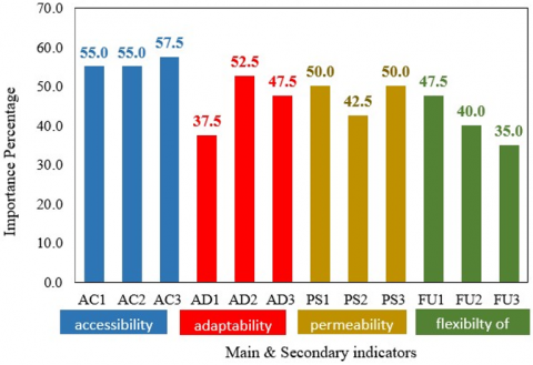
6.2.1 Indicator 1 (accessibility)
The research delves into three key features of urban resilience. AC1 stressed the importance of reaching resources, evacuation possibilities, and safe zones within reasonable distances, with 55% of respondents marking it as highly important or necessary. That benefit not only improves resiliency but also enables and energizes the community's social capital. Next, AC2 explained the importance of a well-functioning and integrated transportation system, where 55% of participants considered it vital to accessibility, community participation. Lastly, AC3 points out the lack of social equity and civic sharing in public spaces, where 57.5% of the participants favored priority for this characteristic. These spaces are essential for social equity, civic participation, and improving the living standards of citizens.
6.2.2 Indicator 2 (adaptability)
The study emphasizes three key factors for improving urban resilience. First, 37.5% of participants firmly agreed that open spaces like parks are useful for recreation and ecological resilience during emergencies. Second, 52.5% of respondents in AD2 highlighted the need for flexible urban planning, including modernized land use and riverbank designs that encourage interaction with nature. Finally, 47.5% of participants in AD3 identified the critical need for adaptive infrastructure to address environmental challenges like floods via sustainable planning and community involvement.
6.2.3 Indicator 3 (permeability and open spaces)
The study aims to examine strategies that will help improve the interconnection of urban areas with the environment. First, PS1 pointed out the great importance of enhancing permeability between the river banks and the city center, which 50% of participants indicated significantly promotes community engagement. Second, 42.5% of participants in PS2 recognized the importance of constructing multifunctional public spaces in strengthening the connection between the river banks and the city center through facilitating social interactions of different attributes. Lastly, PS3 emphasized green corridors, which were supported by 50% of participants who noted that these spaces are important for nurturing. Participants decided that these spaces improve natural permeability and mitigate the urban heat island effect, thereby enhancing the overall quality of life.
6.2.4 Indicator 4 (flexibility of use)
The analysis examines the contribution of green and public areas towards urban resilience. First, FU1 indicates that 47.5% of the participants perceive multifunctional green spaces as highly necessary, suggesting their role in fostering environmental and social resilience. Second, FU2 demonstrates that 40% of respondents rate the multifunctional design of public parks as highly necessary, which indicates an improvement in urban heat islands and community wellbeing. Finally, FU3 points out that 35% of respondents regard the public space redesign as necessary, indicating a growing perception of improving the city’s environmental, social, and economic aspects.
The analysis reveals that respondents are willing to be more proactive in planning resilient cities that provide sufficient resources and the necessary resilience to address environmental and social changes. Participants highlighted the need for more acceptable relations between the riverbanks and the city center, in addition to multifunctional public areas. The results emphasize that green areas significantly enhance city resilience by providing environmental and social benefits, improving quality of life, and fostering social integration.
6.3 Results discussion
A careful analysis of the results reveals significant findings related to the indicators measured in the survey, considering urban resilience and the built environment structures.
6.3.1 Indicator 1 (accessibility)
It is crucial to be able to reach essential resources, evacuation zones, and safe and easy regions. The results suggest the need for connected transportation systems and accessible civic spaces, which guarantee citywide accessibility in urban design to ensure all residents can access the areas during emergencies.
6.3.2 Indicator 2 (adaptability)
The results show that open spaces, like parks, significantly minimize climate change impacts like floods and heat waves. The results support the need for adaptable city planning approaches and the change of land use planning for future environmental and technological issues that require broader collaboration among planners, policymakers, and communities.
6.3.3 Indicator 3 (permeability and open spaces)
The need to improve the relations between the riverbanks and the city center to enhance social interactions and strengthen community ties is important. The findings suggest the need for green corridors to combat the urban heat island effects while fostering active community participation and healthy living through interconnected green spaces.
6.3.4 Indicator 4 (flexibility of use)
Indicator 4 delineates the role of multifunctional green spaces in boosting urban resilience. The participants recognize these areas as vital for social and environmental services, such as harvesting rainwater and cooling the ambient temperatures. The results call for multifunctional public spaces that respond to many demands, thereby increasing the ability of a city to cope with the contending environmental issues, besides improving the quality of life.
This analysis illustrates how nature incorporated into the city promotes ecological preservation and improves the quality of life for residents. Not only does green infrastructure support biodiversity, but it also improves people's health by reducing stress and increasing physical activity levels. Having highly interconnected green spaces helps mitigate climate change effects and improves social interactions, thereby facilitating better mental health and community identity. Moreover, these initiatives help boost local economies by attracting tourists and promoting outdoor activities that foster constructive community involvement. Enhanced property values and higher investment in the area generate additional and sustainable impacts for the environment and people within communities, making it beneficial to both.
The relationship and the idea of urban resilience are closely similar to the four key sustainability indicators regarding the improvement of urban environments. Accessibility allows every man, woman, and child within the bounds of a democracy to have access to crucial services and/or places, which reduces mobility bottlenecks and social exclusion while often leading to increased walking and cycling, the form of inter-city transport with the lowest carbon emission rates. Adaptability concerns the capacity of reserving policy and land use in the context of climate change and new technological innovations towards enabling cities to cope with these new challenges resourcefully and environmentally sustainable. Permeability and open spaces enable green parks and greenways to improve social interaction and cohesion, as well as mitigate urban heat islands and improve air quality to enable the residents' well-being. Flexibility of use supports the possibility for multifunctionality in space use for leisure or community activities like rainwater collection and recreation, improving sustainable resource management and space adjustability in the future. Together, they provide enhanced social equity, environmental resilience, and resource efficiency that help in developing livable and sustainable cities.
The investigation illustrates an integrated design strategy for the riverbanks of medium-sized cities, utilizing the Tigris River in Kut City as a case study. The prototype handles ecological, economic, and social challenges posed by climate change and urbanization via environmental conservation, social relations, and business enterprises. It focuses on three segments: improving accessibility, activating green areas, and enhancing adaptive infrastructure. Accessibility improvements include green passageways, pedestrian bridges, and bicycle tracks that link the city to the river, promoting physical activity. Green areas feature flexible parks and gardens that facilitate social activities while combining flood-reduction features like permeable surfaces. Strategies for adaptive infrastructure involve rainwater harvesting, artificial lakes, and eco-friendly building substances. The design facilitates ecotourism and water entertainment with designated areas for restaurants, cultural events, and local markets, enabling inclusivity for children, large persons, and disabled individuals, thereby expanding the economy through tourism. This prototype suggests a multifunctional green infrastructure network along pedestrian and bike tracks that link residential and commercial zones, helping cities adapt to climate change while balancing sustainability. The design can be executed by different-sized cities utilizing flexible public area indicators incorporated into the river beach framework.
The main indicators observed in Table 2 can be summarized as follows: they aim at primary goals that need to be accomplished to build and maintain a resilient and sustainable urban environment, including improving accessibility, adaptability, enhanced permeability, and flexible utilization of public spaces.
Secondary indicators cover the more specific details that complement the primary indicators and assist the objective towards a sustainable-comprehensive approach.
In the case of Kut City, the matrix proposes strategies that may assist in designing the City, beside the main goal to enhance access to the Tigris River and climate resilience as the primary indicators, while secondary indicators enable the main ones through extra initiatives such as increasing the green network and effective water resources management, as illustrated in Table 2.
Table 2. The main and secondary indicators used to enhance the riverbank in Kut City
|
Indicator |
Key Indicators |
Secondary Indicators |
|
Accessibility |
Improved easy access to resources and safe areas. |
Providing an efficient and interconnected transportation network. |
|
Easy access to public spaces for all social classes. |
Design public spaces to be inclusive and accessible to all. |
|
|
Adaptability |
Adopting flexible urban planning policies to address climate change. |
Providing open spaces to modify use during crises. |
|
Developing adaptive infrastructure that enhances the city’s response to environmental disasters. |
Designing cities to adapt to environmental and climate changes. |
|
|
Permeability and open spaces |
Improving permeability between the river banks and the city center. |
Developing green paths to connect the city to the river banks. |
|
Creating multifunctional spaces on the river banks. |
Improving social communication through open spaces. |
|
|
Flexibility of use |
Designing multi-functional green spaces to enhance flexibility. |
Integrating public spaces to meet multiple social and environmental needs. |
|
Transforming public spaces to support economic and recreational activities. |
Providing flexible spaces that can be used for cultural and sports activities. |
|
|
Environmental sustainability |
Rainwater management through permeable roofs and rain gardens. |
Improving biodiversity and supporting wildlife. |
|
Use of sustainable building materials in the design of public spaces. |
Reducing environmental impacts through green building techniques. |
Developing urban resilience strategies for Al Kut requires dealing with climate change and urban expansion challenges through new and innovative designs. A combination of sustainable design with technical and participatory approaches allows for the conservation of the environment and the expansion of urban areas. The enhancement of public space for social resilience aims to advance economic development while protecting the environment toward sustainable development. River spaces protect the city against flooding and enable ecological diversity that strengthens urban resilience. Introducing green infrastructure in these spaces provides recreational opportunities, strengthens social cohesion, and permits regional environmental adaptation. Applying indigenous vegetation along with water filtration systems leads to environmental sustainability, pollution reduction, and freedom from social injustice, as shown in Figure 6.
Figure 6. Results of the analysis of the four indicators adopted in the questionnaire to enhance urban resilience
A collaborative approach that combines the efforts of public and private entities alongside nonprofit organizations will strengthen Kut City's resilience. Through this partnership, they achieve better coordination while securing funds for green infrastructure initiatives that protect the local ecosystem and sustain projects. Successful environmental sustainability requires the essential participation of local communities. The effectiveness of sustainability efforts improves when different sectors work together with communities that actively participate. Implementing sustainable solutions that align with regional environmental and cultural traits improves when residents participate in planning and design processes. Establishing stronger partnerships between government bodies and community groups leads to sustainable transformations that advance social and environmental objectives.
Figure 7 illustrates the main indicators related to sustainability and their relationship to urban planning to achieve accessibility, adaptability, permeability, open spaces, and flexibility of use.
Figure 7. Key sustainability indicators and their relationship to urban planning: Accessibility, adaptability, permeability, open spaces, and flexibility of use
The study discussed the necessity of improving safe access points to all places alongside the river, which can enhance the city’s crisis response capability and foster social interaction. It placed specific attention on the multifunctional roles of parks and green spaces as new adaptive features toward climate change consequences. They also emphasized the need for ameliorating riverine regions by creating urban-friendly protective environments on the river banks.
The mollification of barriers between the rivers and the urban town was found to also lead to greater social interaction between the city residents, making it more sociable and sustainable. The study also placed great importance on the design of public spaces as it was found that multi-functional spaces promoted social interaction, as well as serving as cooling and biodiversity-encouraging agents.
The study equally gave attention to the need for the adoption of certain policies on urban planning that have an element of flexibility in them, which improves the sustainability of the city while catering to the needs of different parts of society.
This effort suggests boosting connected public transportation systems in order to facilitate access to all parts of the city, including the rivers and safe zones, for improved mobility and effective crisis management. This activity also suggests the integration of flexible urban planning policies that anticipate climate change, especially those that set aside land for multi-functional green spaces that serve to enhance the city’s environment.
The activity also calls for the design of public spaces to foster multi-functionality for the beautification of the urban environment and to foster social interaction, such as rain gardens and permeable pavements. There is also a need to foster environmental permeability by the creation of green corridors and open spaces that link the riverbanks to the city’s center which ultimately contributes to cooler temperatures and better living conditions for the residents.
To achieve the envisioned future, the activity stresses the need to foster community participation in the design processes to ensure all societal needs are addressed, which in turn promotes ownership and responsibility.
Riverbank development is key to strengthening Al Kut´s resilience and is an important part of urban resilience strategies that can help medium-sized cities tackle sustainability challenges. In short, introducing green infrastructure with multipurpose natural corridors can lead to a higher quality of life, alleviation of climate change effects, and more biodiversity. The permeability of riverbanks has been argued to increase urban areas as it encourages more social and economic activity, providing better sustainability for the city. These strategies can set a benchmark for moderate-sized cities and steps towards sustainable and resilient cities worldwide, while implemented in Al Kut.
Shahad Abdul Hussein Aldhahir: Practical work, writing a literature review, and original draft preparation. Husam Sachit Senah: Conceptualization, methodology, data curation, visualization, writing. Adil Mahdi Jabbar: Reviewing and editing, interpretation.
The appendix includes a sample of the questionnaire that includes the eight questions that were analysed, as described below.
Questions of the questionnaire:
Number 1 means not at all important, and 5 means very important.
Q1) Rate the importance of having a river in the city center for your choice of place to live or visit.
Q2) How does having a river in the city center affect your decision about where to stay or visit?
Q3) Do you think the river contributes to improving the city's air quality and microclimate?
Q4) Do you agree to preserve the cultural heritage and historical sites in the city center to enhance economic activity near the river?
Q5) Do riverside spaces encourage people to participate and express their culture?
Q6) How important is it to preserve the cultural identity and vitality of the riverbank?
Q7) How do you evaluate the level of participation of beneficiaries in riverbank planning processes?
Q8) How important is it to implement green spaces and sustainable infrastructure along the riverbank?
Table A1. Survey participants' answers, the numbers indicate the importance of each question
|
No. |
Q1 |
Q2 |
Q3 |
Q4 |
Q5 |
Q6 |
Q7 |
Q8 |
avg _odd |
avg_even |
avg_total |
|
1 |
3 |
1 |
5 |
4 |
5 |
4 |
4 |
4 |
4.25 |
3.25 |
3.75 |
|
2 |
5 |
4 |
5 |
3 |
1 |
5 |
3 |
5 |
3.50 |
4.25 |
3.875 |
|
3 |
4 |
3 |
5 |
5 |
5 |
5 |
3 |
5 |
4.25 |
4.50 |
4.375 |
|
4 |
3 |
3 |
5 |
5 |
3 |
5 |
5 |
5 |
4.00 |
4.50 |
4.250 |
|
5 |
5 |
5 |
5 |
5 |
5 |
5 |
2 |
5 |
4.25 |
5.00 |
4.625 |
|
6 |
5 |
4 |
5 |
5 |
4 |
5 |
4 |
5 |
4.50 |
4.75 |
4.625 |
|
7 |
4 |
3 |
4 |
4 |
4 |
5 |
4 |
5 |
4.00 |
4.25 |
4.125 |
|
8 |
5 |
5 |
5 |
5 |
4 |
2 |
3 |
5 |
4.25 |
4.25 |
4.250 |
|
9 |
5 |
2 |
4 |
5 |
5 |
4 |
1 |
5 |
3.75 |
4.00 |
3.875 |
|
10 |
5 |
5 |
5 |
5 |
5 |
5 |
1 |
5 |
4.00 |
5.00 |
4.500 |
|
11 |
5 |
4 |
5 |
4 |
3 |
4 |
3 |
3 |
4.00 |
3.75 |
3.875 |
|
12 |
5 |
5 |
5 |
4 |
4 |
5 |
4 |
5 |
4.50 |
4.75 |
4.625 |
|
13 |
3 |
3 |
4 |
5 |
5 |
5 |
2 |
5 |
3.50 |
4.50 |
4.000 |
|
14 |
5 |
5 |
5 |
5 |
5 |
5 |
5 |
5 |
5.00 |
5.00 |
5.000 |
|
15 |
5 |
3 |
4 |
5 |
2 |
5 |
3 |
5 |
3.50 |
4.50 |
4.000 |
|
16 |
5 |
4 |
5 |
5 |
4 |
4 |
1 |
5 |
3.75 |
4.50 |
4.125 |
|
17 |
3 |
4 |
3 |
2 |
4 |
4 |
3 |
3 |
3.25 |
3.25 |
3.250 |
|
18 |
5 |
3 |
5 |
5 |
1 |
5 |
3 |
5 |
3.50 |
4.50 |
4.000 |
|
19 |
5 |
4 |
5 |
5 |
2 |
5 |
3 |
5 |
3.75 |
4.75 |
4.250 |
|
20 |
3 |
3 |
3 |
3 |
3 |
3 |
4 |
4 |
3.25 |
3.25 |
3.250 |
|
21 |
5 |
5 |
5 |
5 |
5 |
5 |
5 |
5 |
5.00 |
5.00 |
5.00 |
|
22 |
4 |
4 |
4 |
4 |
4 |
4 |
2 |
5 |
3.50 |
4.25 |
3.875 |
|
23 |
5 |
5 |
4 |
4 |
3 |
4 |
4 |
4 |
4.00 |
4.25 |
4.125 |
|
24 |
5 |
5 |
4 |
4 |
3 |
4 |
4 |
4 |
4.00 |
4.25 |
4.125 |
|
25 |
3 |
2 |
5 |
5 |
3 |
5 |
3 |
5 |
3.50 |
4.25 |
3.875 |
|
26 |
5 |
5 |
5 |
5 |
2 |
3 |
2 |
5 |
3.50 |
4.50 |
4.000 |
|
27 |
5 |
3 |
4 |
5 |
4 |
5 |
3 |
5 |
4.00 |
4.50 |
4.250 |
Table A2. Values of x and y to calculate the correlation and reliability coefficients
|
No. |
x |
y |
xy |
x2 |
y2 |
|
avg _odd |
avg_even |
||||
|
1 |
4.25 |
3.25 |
13.8125 |
18.0625 |
10.5625 |
|
2 |
3.50 |
4.25 |
14.8750 |
12.2500 |
18.0625 |
|
3 |
4.25 |
4.50 |
19.1250 |
18.0625 |
20.2500 |
|
4 |
4.00 |
4.50 |
18.0000 |
16.0000 |
20.2500 |
|
5 |
4.25 |
5.00 |
21.2500 |
18.0625 |
25.0000 |
|
6 |
4.50 |
4.75 |
21.3750 |
20.2500 |
22.5625 |
|
7 |
4.00 |
4.25 |
17.0000 |
16.0000 |
18.0625 |
|
8 |
4.25 |
4.25 |
18.0625 |
18.0625 |
18.0625 |
|
9 |
3.75 |
4.00 |
15.0000 |
14.0625 |
16.0000 |
|
10 |
4.00 |
5.00 |
20.0000 |
16.0000 |
25.0000 |
|
11 |
4.00 |
3.75 |
15.0000 |
16.0000 |
14.0625 |
|
12 |
4.50 |
4.75 |
21.3750 |
20.2500 |
22.5625 |
|
13 |
3.50 |
4.50 |
15.7500 |
12.2500 |
20.2500 |
|
14 |
5.00 |
5.00 |
25.0000 |
25.0000 |
25.0000 |
|
15 |
3.50 |
4.50 |
15.7500 |
12.2500 |
20.2500 |
|
16 |
3.75 |
4.50 |
16.8750 |
14.0625 |
20.2500 |
|
17 |
3.25 |
3.25 |
10.5625 |
10.5625 |
10.5625 |
|
18 |
3.50 |
4.50 |
15.7500 |
12.2500 |
20.2500 |
|
19 |
3.75 |
4.75 |
17.8125 |
14.0625 |
22.5625 |
|
20 |
3.25 |
3.25 |
10.5625 |
10.5625 |
10.5625 |
|
21 |
5.00 |
5.00 |
25.0000 |
25.0000 |
25.0000 |
|
22 |
3.50 |
4.25 |
14.8750 |
12.2500 |
18.0625 |
|
23 |
4.00 |
4.25 |
17.0000 |
16.0000 |
18.0625 |
|
24 |
4.00 |
4.25 |
17.0000 |
16.0000 |
18.0625 |
|
25 |
3.50 |
4.25 |
14.8750 |
12.2500 |
18.0625 |
|
26 |
3.50 |
4.50 |
15.7500 |
12.2500 |
20.2500 |
|
27 |
4.00 |
4.50 |
18.0000 |
16.0000 |
20.2500 |
|
Sum |
106.25 |
117.5 |
465.4375 |
423.8125 |
517.875 |
[1] Moraci, F., Errigo, M.F., Fazia, C., Campisi, T., Castelli, F. (2020). Cities under pressure: Strategies and tools to face climate change and pandemic. Sustainability, 12(18): 7743. https://doi.org/10.3390/su12187743
[2] Chaoui, G., Yaagoubi, R., Mastere, M. (2025). Integrating geospatial technologies and multi-criteria decision analysis for sustainable and resilient urban planning. Challenges in Sustainability, 13(1): 122-134. https://doi.org/10.56578/cis130109
[3] Alhussen, S., Senah, H.S. (2024). Urban landscape resilience: Reconnecting the river with Al-Kut's traditional city centre. Wasit Journal of Engineering Sciences, 12(4): 191-202. https://doi.org/10.31185/ejuow.vol12.iss4.590
[4] Cariolet, J.M., Vuillet, M., Diab, Y. (2019). Mapping urban resilience to disasters - A review. Sustainable Cities and Society, 51: 101746. https://doi.org/10.1016/j.scs.2019.101746
[5] Ribeiro, P.J.G., Pena Jardim Gonçalves, L.A. (2019). Urban resilience: A conceptual framework. Sustainable Cities and Society, 50: 101625. https://doi.org/10.1016/j.scs.2019.101625
[6] O'Donnell, E., Thorne, C., Ahilan, S., Arthur, S., Birkinshaw, S., Butler, D., Dawson, D., Everett, G., Fenner, R., Glenis, V., Kapetas, L., Kilsby, C., Krivtsov, V., Lamond, J., Maskrey, S., O'Donnell, G., Potter, K., Vercruysse, K., Vilcan, T., Wright, N. (2019). The blue-green path to urban flood resilience. Blue-Green Systems, 2(1): 28-45. https://doi.org/10.2166/bgs.2019.199
[7] Chan, F.K.S., Griffiths, J.A., Higgitt, D., Xu, S., Zhu, F., Tang, Y.T., Xu, Y., Thorne, C.R. (2018). "Sponge city" in China - A breakthrough of planning and flood risk management in the urban context. Land Use Policy, 76: 772-778. https://doi.org/10.1016/j.landusepol.2018.03.005
[8] Ebrahimian, A., Sokolovskaya, N., Wadzuk, B. (2021). Modeling dynamic performance of urban infiltration trench systems: Methodology and a case study in Philadelphia. Journal of Hydrology, 594: 125938. https://doi.org/10.1016/j.jhydrol.2020.125938
[9] Rezvani, S.M.H.S., Falcão, M.J., Komljenovic, D., de Almeida, N.M. (2023). A systematic literature review on urban resilience enabled with asset and disaster risk management approaches and GIS-based decision support tools. Applied Sciences, 13(4): 2223. https://doi.org/10.3390/app13042223
[10] Paudel, S., States, S.L. (2023). Urban green spaces and sustainability: Exploring the ecosystem services and disservices of grassy lawns versus floral meadows. Urban Forestry & Urban Greening, 84: 127932. https://doi.org/10.1016/j.ufug.2023.127932
[11] Ashinze, U.K., Edeigba, B.A., Umoh, A.A., Biu, P.W., Daraojimba, A.I. (2024). Urban green infrastructure and its role in sustainable cities: A comprehensive review. World Journal of Advanced Research and Reviews, 21(2): 928-936. https://doi.org/10.30574/wjarr.2024.21.2.0519
[12] Lv, Y., Sarker, M.N.I. (2024). Integrative approaches to urban resilience: Evaluating the efficacy of resilience strategies in mitigating climate change vulnerabilities. Heliyon, 10(6): e28191. https://doi.org/10.1016/j.heliyon.2024.e28191
[13] Hemmati, M., Ellingwood, B.R., Mahmoud, H.N. (2020). The role of urban growth in resilience of communities under flood risk. Earth's Future, 8(3). https://doi.org/10.1029/2019EF001382
[14] Yang, R., Zhen, F. (2024). Smart city development models: A cross-cultural regional analysis from theory to practice. Research in Globalization, 8: 100221. https://doi.org/10.1016/j.resglo.2024.100221
[15] Aivazidou, E., Banias, G., Lampridi, M., Vasileiadis, G., Anagnostis, A., Papageorgiou, E., Bochtis, D. (2021). Smart technologies for sustainable water management: An urban analysis. Sustainability, 13(24): 13940. https://doi.org/10.3390/su132413940
[16] Fereshtehpour, M., Najafi, M.R. (2025). Urban stormwater resilience: Global insights and strategies for climate adaptation. Urban Climate, 59: 102290. https://doi.org/10.1016/j.uclim.2025.102290
[17] Paes, V.C., Pessoa, C.H.M., Pagliusi, R.P., Barbosa, C.E., Argôlo, M., de Lima, Y.O., Salazar, H., Lyra, A., de Souza, J.M. (2023). Analyzing the challenges for future smart and sustainable cities. Sustainability, 15(10): 7996. https://doi.org/10.3390/su15107996
[18] Li, J., Guo, Z. (2024). Leveraging greenspace to manage urban flooding: An investigation of nature-based solutions implementation in U.S. public parks. Land, 13(9): 1531. https://doi.org/10.3390/land13091531
[19] Cao, H. (2023). Urban resilience: Concept, influencing factors and improvement. Frontiers in Business, Economics and Management, 9(1): 343-346. https://doi.org/10.54097/fbem.v9i1.8777
[20] Wang, D., Xu, P.Y., An, B.W., Guo, Q.P. (2024). Urban green infrastructure: Bridging biodiversity conservation and sustainable urban development through adaptive management approach. Frontiers in Ecology and Evolution, 12. https://doi.org/10.3389/fevo.2024.1440477
[21] Hickford, A.J., Blainey, S.P., Ortega Hortelano, A., Pant, R. (2018). Resilience engineering: Theory and practice in interdependent infrastructure systems. Environment Systems and Decisions, 38(3): 278-291. https://doi.org/10.1007/s10669-018-9707-4
[22] Walker, B., Holling, C.S., Carpenter, S.R., Kinzig, A.P. (2004). Resilience, adaptability and transformability in social-ecological systems. Ecology and Society, 9(2). https://doi.org/10.5751/es-00650-090205
[23] Tajuddin, N., Dąbrowski, M. (2021). Enabling socio-ecological resilience in the global south: Insights from Chennai, India. Sustainability, 13(19): 10522. https://doi.org/10.3390/su131910522
[24] Asadzadeh, A., Khavarian-Garmsir, A.R., Sharifi, A., Salehi, P., Kötter, T. (2022). Transformative resilience: An overview of its structure, evolution, and trends. Sustainability, 14(22): 15267. https://doi.org/10.3390/su142215267
[25] Kapucu, N., Ge, Y., Rott, E., Isgandar, H. (2024). Urban resilience: Multidimensional perspectives, challenges and prospects for future research. Urban Governance, 4(3): 162-179. https://doi.org/10.1016/j.ugj.2024.09.003
[26] Semeraro, T., Aretano, R., Pomes, A. (2017). Green infrastructure to improve ecosystem services in the landscape urban regeneration. IOP Conference Series: Materials Science and Engineering, 245: 082044. https://doi.org/10.1088/1757-899x/245/8/082044
[27] Mul, B., Bakker, M. (2018). Land-ownership and biodiversity in agricultural Utrecht. https://edepot.wur.nl/459960.
[28] Coops, H., Van Geest, G. (2007). Ecological restoration of wetlands in Europe; significance for implementing the Water Framework Directive in the Netherlands. WL/Delft Hydraulics. https://www.researchgate.net/publication/235005665_Ecological_restoration_of_wetlands_in_Europe_significance_for_implementing_the_Water_Framework_Directive_in_the_Netherlands.
[29] Bakri, A. (1967). Kut history. Al-Ani Publisher. https://search.worldcat.org/title/tarykh-alkwt/oclc/700392366.
[30] Tikkanen, A., Parwani, N. (2011). Al-Kut. Britannica. https://www.britannica.com/place/Al-Kut.
[31] Iraq, R. (2024). Ministry of planning - central statistical organization. Repub. Iraq Minist. Plan. https://cosit.gov.iq/ar/?option=com_content&view=article&layout=edit&id=1214.