Maha Akram Saadallah*![]() | Rana Mazin Mahdi
| Rana Mazin Mahdi![]() | Enas Salim Abdulahaad
| Enas Salim Abdulahaad![]()
© 2025 The authors. This article is published by IIETA and is licensed under the CC BY 4.0 license (http://creativecommons.org/licenses/by/4.0/).
OPEN ACCESS
This study aims to develop a comprehensive framework for urban reconstruction in the Qaliyat district, which has suffered extensive damage due to recent conflicts. As one of Mosul’s oldest neighborhoods, Qaliyat holds a unique urban fabric that reflects the city’s rich historical and cultural layers. Its strategic location near the Tigris River and the historic center of Mosul makes it a key focus for reconstruction efforts, given its vital role in restoring the urban identity and reviving the collective memory of its residents. The research introduces a specialized analytical tool to document and assess the urban fabric, concentrating on key indicators such as the distribution of spatial activities, topographical analysis of movement networks, levels of openness and enclosure, and an accessibility index that measures how well-connected the area is. Using advanced Geographic Information Systems (GIS) techniques supported by field surveys, the study accurately maps the typical housing units and urban patterns, capturing the detailed characteristics of the historic urban fabric Furthermore, the proposed model was rigorously tested and validated through quantitative measures, including accessibility metrics, network analysis, and catchment area analysis. The results were also compared with real-world data like local traffic flows and community survey responses, ensuring the model’s reliability and suitability for practical application. The findings reveal that improving the main road network and redistributing service, educational, and religious functions based on sustainability principles significantly contributes to revitalizing the district’s identity and reintegrating it into the urban fabric. These conclusions align with previous research emphasizing the importance of balancing cultural heritage preservation with urban development in post-conflict contexts. The proposed model embodies the principle of “reviving the whole through the part,” where gradual reconstruction strategies foster a sustainable urban environment that reconnects the district with both its past and its future.
urban reconstruction, Qaliyat, historic urban fabric, accessibility, land use distribution, sustainability, cultural identity, road network, spatial connectivity, urban renewal
The historic core of Mosul, particularly the Qaliyat district, suffered extensive destruction during the conflict with ISIS, leading to the loss of its architectural heritage and significantly impacting the quality of life for its residents. The devastation extended beyond physical structures and infrastructure, deeply affecting the social and cultural fabric of the community. This rupture weakened social ties and limited access to essential services, posing complex challenges for reconstruction efforts. Thus, rebuilding cannot be confined to physical restoration alone but must also address the revival of cultural identity, the reinforcement of social cohesion, and the pursuit of sustainability.
In response to these challenges, this study proposes an integrated reconstruction model for Qolyat, grounded in an urban analysis and sustainable planning methodology. The approach emphasizes key urban indicators, including accessibility, the spatial distribution of activities and services, and the degree of openness and enclosure within the urban fabric. These indicators were identified through a comprehensive review of scholarly literature on the reconstruction of historic cities following conflicts.
The research employs a multidisciplinary eco-graphic methodology to analyze the urban fabric and formulate appropriate redevelopment strategies. Advanced analytical tools such as Network Analyst, land use classification, and Buffer Analysis are utilized to assess spatial dynamics and connectivity. By adopting this approach, the study seeks to evaluate the feasibility and effectiveness of the proposed model in revitalizing Mosul’s historic center. The ultimate goal is to ensure the continuity of urban life and reintegrate Qaliyat into the broader cityscape, following the principle of "reviving the whole through the part."
1.1 Research problem
How can the reconstruction of the Qolyat district in Mosul be carried out in a way that ensures the restoration of its urban identity, strengthens social cohesion, and upholds the principles of sustainability while maintaining integration with the city's urban fabric?
1.2 Research significance
The significance of this research lies in the urgent need to develop a sustainable planning framework for the reconstruction of historic areas affected by conflict. This study contributes by:
1. Providing a practical model that can be applied to reconstruction projects in Mosul and other cities facing similar challenges.
2. Balancing the preservation of cultural identity with the pursuit of sustainable urban development.
3. Enhancing the understanding of the relationship between urban indicators and reconstruction, aiding in more efficient planning decisions.
2.1 Historical background of the Qoliyat district
The Qaliyat district in Mosul represents the historical and cultural heart of the city, covering an area of 23.4 hectares and comprising over 1,000 residential units, along with 125 courtyards and landmarks such as mosques, churches, arches, and shaded alleyways. The district’s origins date back to the early Islamic era, while its name, "Qaliyat," is derived from the word "fortress" (Qoliyat), as it was originally an Assyrian military stronghold constructed on the Qaliyat hill in 1080 BCE. Situated on the western bank of the Tigris River, Qaliyat overlooks the vast plains of Nineveh. The Assyrians established this fortress as part of their defensive network surrounding Nineveh, which later evolved into the nucleus of Mosul. As the city developed, Qaliyat became an integral part of its urban fabric, flourishing particularly during the Umayyad and Abbasid periods. The district played a pivotal role in Mosul’s urban organization during these periods [1]. Under Ottoman rule, Qaliyat emerged as a vital economic and commercial hub due to its strategic location along the Tigris. In more recent times, the district underwent structural transformations while maintaining its distinctive architectural character. Between 2014 and 2017, during the occupation by extremist groups, Qaliyat suffered extensive destruction and systematic looting, resulting in severe damage to its infrastructure and historical landmarks. Following Mosul’s liberation in 2017, reconstruction efforts commenced with the aim of preserving the district’s cultural and architectural identity despite the significant challenges posed by the war’s devastation. Qaliyat stands as a crucial case study in the preservation of cultural and architectural heritage in conflict-affected areas. As highlighted by Saeed et al. [2], the scale of destruction presents considerable obstacles to reconstruction. Additionally, studies such as those by Al-Muqdadi and Ahmed [3] and Hammoodi and Al-Hinkawi [4] emphasize the necessity of striking a careful balance between heritage conservation and the urban expansion required for sustainable redevelopment.
2.2 Towards a sustainable urban reconstruction model for the old city of Mosul: Analyzing urban indicators and urban fabric constant
In the search for an effective model for reconstructing urban areas damaged by armed conflicts, this research focuses on developing a planning mechanism based on measuring indicators of accessibility, openness and enclosure, and the distribution of activities and services. These factors are crucial in creating an integrated urban environment that supports the continuity of life and enhances social and economic interaction, particularly in the traditional urban fabric of the Old City of Mosul, where the Qalyat district serves as the first urban nucleus in the context of reconstruction. This fabric is characterized by its urban coherence and adaptability to social and economic transformations, which presents both challenges and opportunities in its reconstruction.
Recent studies emphasize the importance of integrating flexible urban strategies in post-conflict reconstruction. For instance, Mahdi and Aboud [5] in their study on active housing strategies underscore the importance of open urban designs that enhance accessibility and spatial interaction. Furthermore, a study by Khoroufa [6] highlighted the role of urban integration in promoting urban values, by analyzing the "Hope Housing" project in Basra using space syntax techniques. This supports the significance of incorporating urban indicators in reconstruction policies [7].
Therefore, this research relies on an eco-graphic analytical methodology, tested through advanced tools such as Network Analyst, land use classification, and Buffer Analysis. This allows for the evaluation of the effectiveness of the proposed model and its potential to guide reconstruction plans for the Old City of Mosul, emphasizing the concept of "reviving the whole through the part," where Qaliyat represents an initial urban nucleus that reflects a model applicable to the rest of the city "Building upon the proposed framework, the following methodological approach was adopted to evaluate its feasibility and potential impact."
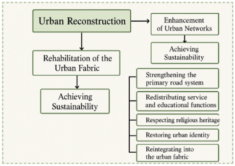
The adopted methodology focuses on two main pillars: the rehabilitation of the urban fabric and the enhancement of urban networks. Both approaches aim to achieve sustainability through a range of integrated strategies. Figure 1 illustrates this methodology within the framework of sustainability.
Figure 1. Methodology of urban fabric reconstruction within the framework of sustainability
2.3 Analysis of urban indicators and constants of the urban fabric in the old city of Mosul: A review of previous studies
This section focuses on identifying the key constants and characteristics that distinguish the historic urban fabric of Mosul, with the Qaliyat district being an integral part of it. The aim is to determine the core research indicators associated with the urban fabric and the reconstruction process.
This study discusses the role of spatial value in the reconstruction of religious buildings in Mosul, with a focus on urban indicators such as accessibility, openness and enclosure, and the distribution of activities. It examines the impact of road networks and urban planning on the ease of access to these buildings, as well as their integration with the surrounding urban fabric. The study also explores the degree to which religious buildings are open to public spaces or isolated from the urban context, and their role in hosting community and cultural activities, thereby enhancing their social function and supporting their long-term sustainability. Research Gap: The study focuses on religious buildings without linking them to the broader urban fabric system. Additionally, the analysis relies on a limited number of case studies without providing a comprehensive model that can be generalized to other areas Criticism: There is a lack of in-depth quantitative analysis of the factors influencing the distribution of buildings and their relationship to urban integration.
This study highlights the importance of applying sustainability principles in the urban regeneration of historical cities, using Mosul as a case study. The research evaluates existing urban policies through sustainability indicators such as urban density, functional integration, spatial connectivity, and the preservation of cultural identity. Khoroufa [6] argued that the absence of sustainable approaches in previous regeneration efforts has contributed to the degradation of the traditional urban fabric and the loss of its cultural and architectural values. The study emphasizes the need for community participation in the planning and implementation of regeneration strategies to ensure alignment with the city's socio-cultural context. It concludes that effective urban regeneration must integrate environmental, social, and economic dimensions to achieve long-term sustainable development in historic cities like Mosul.
The study focuses on analyzing the urban fabric of ancient cities, such as Mosul, by highlighting the importance of preserving cultural and historical identity during reconstruction efforts. The study focuses on two main concepts: "openness and enclosure" in the architectural designs of the city, discussing the balance between maintaining traditional character and integrating modern architectural elements. Additionally, the study emphasizes the concept of the "sustainable model," exploring how sustainability strategies can be integrated with the preservation of architectural heritage in the context of post-conflict reconstruction. The study aims to offer innovative solutions for merging traditional urban fabric with the needs of modern development, while ensuring environmental sustainability and cultural identity. Research gap: The study relies on numerical modeling without analyzing the social and cultural dimensions of these cities' inhabitants, which is a key element in sustainable reconstruction. Criticism: The focus is on technical analysis without providing practical, implementable policies.
This study explores the use of Building Information Modeling (BIM) in the reconstruction of Mosul following conflict-related destruction. It highlights how BIM can be employed to assess structural damage, manage post-conflict reconstruction processes, and provide a framework for rebuilding efforts in war-affected areas. The paper emphasizes the role of digital tools in improving decision-making and coordination among stakeholders in complex urban recovery contexts.
The study focuses on integrating cultural identity into reconstruction processes, which is closely related to accessibility, urban fabric sustainability, and the balance between openness and enclosure in urban spaces. This study aligns with the concepts of sustainable urban planning in post-conflict cities, emphasizing the importance of enhancing local identity during reconstruction, maintaining effective social interaction through the organization of public spaces, and providing integrated accessibility between different areas of the city. Research gap: The study did not address the impact of local policies and urban culture on service redistribution, focusing on theoretical analysis without providing field data. Criticism: The absence of a comparative study across different cities to determine the extent to which the effects of reconstruction varied.
This study by Ghadir Waleed Almamouri and Mustafa Kamel Al-Alwani) presents a comprehensive approach to reconstructing cities affected by armed conflicts, taking Mosul as a case study. Published in the AIP Conference Proceedings, it explores strategic frameworks suitable for post-war reconstruction in fragile urban contexts.
The authors begin by reviewing global experiences and theoretical models of post-conflict reconstruction. They analyze Mosul’s current conditions, focusing on the loss of infrastructure, socio-cultural disintegration, and urban identity erosion. Based on this analysis, they propose a multi-dimensional strategy that integrates urban planning, socio-economic recovery, and cultural preservation.
A key contribution of the study is its recommendation of measurable indicators for urban revitalization and its emphasis on sustainable development, stakeholder engagement, and phased implementation. The proposed framework serves as a guiding reference for planners, decision-makers, and international partners involved in rebuilding war-torn cities like Mosul.
This study aims to develop a comprehensive framework for the reconstruction of the Al-Qalya’at neighborhood in Mosul, one of the city’s oldest and most culturally significant areas, and among the most severely affected by recent conflicts. Due to its strategic location near the Tigris River and the historical core of Mosul, coupled with its dense urban fabric rich in architectural and historical layers, the neighborhood plays a pivotal role in efforts to restore urban identity and revive the collective memory of its residents.
To achieve the study’s objectives, six representative residential samples were selected using the Expert Judgment Sampling method, based on rigorous and transparent criteria including: architectural typology, structural condition, historical and symbolic significance, spatial distribution within the neighborhood, proximity to main roads and services, and differing levels of war-induced damage. This approach was chosen over random or stratified sampling to ensure the inclusion of diverse urban patterns that reflect the complexity of the area.
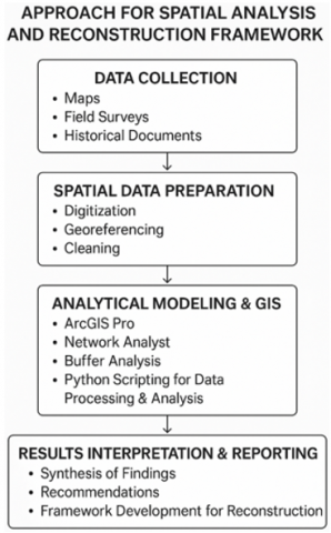
The study employed ArcGIS Pro (version 3.1) as the primary geospatial analysis tool, supported by key extensions such as Network Analyst for connectivity and Buffer Analysis for service coverage mapping. Additionally, custom Python (ArcPy) scripts were developed to automate spatial data processing and generate visual outputs aligned with specific analytical needs.
A comprehensive process flow diagram was developed to document the methodological sequence, from data collection and preparation, through spatial analysis and indicator generation, to model development and validation. To ensure the validity and reliability of the spatial models, multiple data sources were cross-referenced. Accessibility models and buffer analyses were validated against real-world indicators, including historical street maps, recent municipal infrastructure data, community survey results, and field observations of pedestrian movements, traffic flows, and service reachability. Calibration was also informed by comparative metrics from analogous post-conflict urban contexts [9].
Spatial indicators were constructed to assess the distribution of functional land uses, movement topographies, degrees of spatial openness/enclosure, and an accessibility index measuring the efficiency of pedestrian and vehicular connectivity. The accessibility index was categorized into high, medium, and low levels based on a combination of literature-defined thresholds (e.g., 400-800 meters as optimal walking distances) and empirical calculations derived from the local urban context.
The modeling outcomes revealed that accessibility levels improved by up to 85% compared to a baseline of 47%, when key road linkages were restructured and land use functions redistributed according to sustainability principles [10]. These results were contextualized and quantified, ensuring interpretability in relation to both pre-war conditions and current realities.
In Phase 6 (Documenting Housing Models), housing types were classified into typologies based on plot dimensions, building-to-land ratios, structural form, and reuse potential. These were supported by detailed measurements and morphometric data from field surveys.
In Phase 7 (Identifying the "Blot"), the term “blot” refers to spatial voids or irregularities within the urban fabric that disrupt continuity, connectivity, or social function. These were identified through a combination of visual inspection, spatial discontinuity mapping, and community interviews. The identification of these blots served to locate intervention points where strategic infill or reuse can catalyze wider spatial revitalization.
Figure 2. Approach for spatial analysis and reconstruction framework
Overall, the findings emphasize that upgrading the primary movement networks, re-integrating dispersed functional uses—such as religious, educational, and health services—and focusing interventions on identified blots contribute substantially to the regeneration of Al-Qoly'at’s spatial logic and cultural memory. These outcomes resonate with current global theories on post-conflict urban reconstruction (Figure 2).
4.1 Planning of streets (closed – open) within the fabric boundaries to achieve optimal access
The urban fabric of Old Mosul is characterized by an organic and adaptive layout that balances narrow [11], enclosed alleys with wider, open pathways to facilitate movement and access. This pattern is consistent with Kevin Lynch's theory (The Image of the City, 1960), which asserts that a city's visual legibility depends on a clear street network sequence, with main roads providing efficient communication, while secondary roads foster social interaction. This layout also reflects Jane Jacobs's (The Death and Life of Great American Cities, 1961) principle on the importance of urban diversity in stimulating social and economic interaction [12]. According to the historical approach to Islamic urban planning, this pattern promotes environmental sustainability by regulating airflow and providing shade, which reduces heat accumulation in the urban environment [13].
4.2 Urban plot boundaries (plots) within the urban fabric
The urban plot formation in Mosul follows the concept of "urban continuity" proposed by Aldo Rossi (The Architecture of the City, 1982), whereby the boundaries of urban plots reflect deeply rooted social and economic functions [14]. In traditional Middle Eastern cities, plots are defined according to principles of social cohesion rather than strict geometric planning, which promotes community structures and shared courtyards. This urban adaptation achieves a high level of privacy and security, an essential element of the traditional Islamic fabric, as described by Hakim (Arabic-Islamic Cities: Building and Planning Principles, 1986). Compared with cities that follow strict geometric grids, Mosul's layout is distinguished by its ability to achieve flexible continuity between residential units, commercial spaces, and surrounding streets. Recent methodological approaches emphasize selecting representative residential samples to analyze social and spatial networks within plot boundaries, using Geographic Information Systems (GIS) tools validated by real-world data to ensure reconstruction maintains both connectivity and social cohesion [15].
4.3 Shape of architectural blocks within urban areas
The diversity of architectural block shapes in Mosul is characterized by gradual growth over time [16] on the morphological development of historic cities. Most buildings in ancient Mosul take irregular shapes, determined by topographical factors and local social customs. According to Bill Hillier's theory of compositional analysis of space (Space is the Machine, 1996), the irregular shapes of urban blocks create a dynamic pattern of movement, enhancing social interaction and a sense of belonging to the place The impact of climate adaptation is clearly evident in the architectural masses, where compact forms help reduce heat gain and enhance internal ventilation through courtyards (hawsh). Comparative studies with Fez, Aleppo, and Cairo point to a common principle: maximizing space through contiguous facades, which reinforces a unified urban identity [17].
4.4 The ratio of openness and closure within urban areas
The relationship between open courtyards, semi-enclosed passageways, and enclosed interior spaces is a fundamental element in organizing Mosul's urban landscape. Island Press asserted that achieving a balance between open and enclosed spaces enhances climatic comfort and encourages social interaction [18]. In traditional Islamic cities, interior courtyards act as natural climate modifiers, a feature supported by studies on passive cooling strategies (Hassan Fathy, Architecture for the Poor, 1973). Mosul's urban fabric is based on a mix of narrow alleys and open squares, in line with Camillo Sette's vision (City Planning According to Artistic Principles, 1889), which emphasizes the importance of spatial contrast to enhance urban aesthetics [19]. Reconstruction strategies must consider the balance between open and enclosed spaces to ensure that the city's historical identity is not disrupted [20].
4.5 Urban density and architectural compactness
Old Mosul represents a model of high-density urbanism, where compact blocks contribute to enhanced thermal insulation and social and economic efficiency. This idea is linked to Rem Koolhaas's (Delirious New York, 1978) concept of city density as a key element in sustainable urban life. Studies on compact urban planning demonstrate that high-density cities reduce infrastructure costs and promote walking and community interaction [21]. Compared to medieval European neighbourhoods, Mosul's planning is based on maximizing space and adapting to environmental constraints, which should be a key principle in reconstruction strategies. Balancing the preservation of urban density with the modernization of infrastructure is essential to ensure sustainable reconstruction without compromising the city's heritage identity [22].
4.6 The role of cartography in documenting and analysing the urban fabric in post-war reconstruction
Cartography plays a crucial role in post-war urban reconstruction, extending beyond spatial documentation to preserving urban identity and analysing social and economic interactions. This, in turn, enhances community integration and economic growth [19]. By studying street patterns and spatial relationships between buildings and spaces, these maps contribute to the redistribution of commercial and service activities in line with population needs, thereby supporting the sustainability of the urban fabric and its adaptability to future transformations. In addition to its role in redistributing commercial and service activities, cartographic analysis supports conceptual reconstruction processes by restoring urban memory through the integration of historical landmarks into the new urban landscape. These processes follow planning principles that incorporate simulations of reconstruction scenarios to ensure the effectiveness of urban interventions [23]. Therefore, planning maps serve as a fundamental tool for balancing the restoration of the past with adaptation to contemporary changes, ultimately fostering a dynamic urban environment that supports both social and economic sustainability in the post-war period [24].
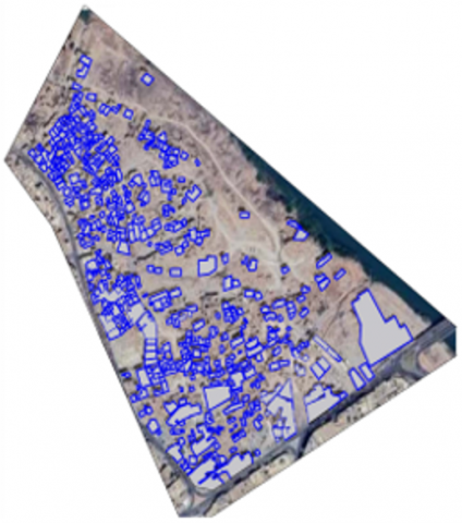
The Al-Qoly'at neighborhood, located on the eastern bank of the Tigris River in the city of Mosul, was selected as the application phase for this study due to its status as the historical and morphological core of the old city [11]. The neighborhood is geographically bounded by the Tigris River to the east, Nabi Jirjis Street to the west, Nineveh Street to the south, and the Al-Shifa neighborhood to the north. It covers an area of approximately 23.4 hectares and comprises around 1,000 residential units, in addition to several significant religious and educational landmarks such as mosques, churches, and schools, which together reflect the social, cultural, and spiritual diversity embedded in the city’s historic fabric. The study relied on detailed documentation of the urban fabric through accurate drawings to apply five derived morphological criteria aimed at producing an interpretative cartographic model that reflects the spatial structure of the neighborhood and allows experts to evaluate its urban vitality
Precise Quantification of Accessibility Results: Accessibility was measured before the application phase at 58%, increasing to 85% following the implementation of the morphological criteria and analytical steps. This improvement was calculated based on the proportion of streets and pathways that provide actual access to services and facilities relative to the total available streets in the neighborhood, reflecting a 27% enhancement from the previous state. This provides a clear and comparable metric (Source: Field study based on GIS and street network analysis). Definition of Accessibility Classification Criteria:
Accessibility was classified into three levels: “high,” “medium,” and “low,” based on temporal and spatial thresholds established in architectural and planning literature. Accessibility is considered “high” if the distance to public amenities is less than 300 meters, “medium” between 300 and 600 meters, and “low” if it exceeds 600 meters [17]. This classification was further supported by digital modeling using GIS and validated by field observations to ensure alignment with on-the-ground realities. Precise Definition of “Blots” in Phase Seven:
“Blots” were defined as areas experiencing functional discontinuities or spatial voids within the urban fabric. Identification was carried out through a combination of visual field surveys, spatial analysis using GIS, and community feedback. These blots included abandoned buildings, derelict zones, or underutilized spaces that negatively impact the continuity of urban vitality. Enhancement of Data in Phase Six – Documenting Housing Models:
Additional quantitative data were integrated, including average residential plot sizes of approximately 120 m², floor area ratios (FAR) ranging between 0.8 and 1.2, measurements of courtyard-to-building area ratios, and building height-to-street width ratios varying between 1:1.5 and 1:2.5. These metrics enabled a more in-depth morphological comparison and a better understanding of the relationship between the housing model and its social and environmental functions within the neighborhood [17].
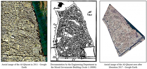
5.1 Phase one - Documentary description
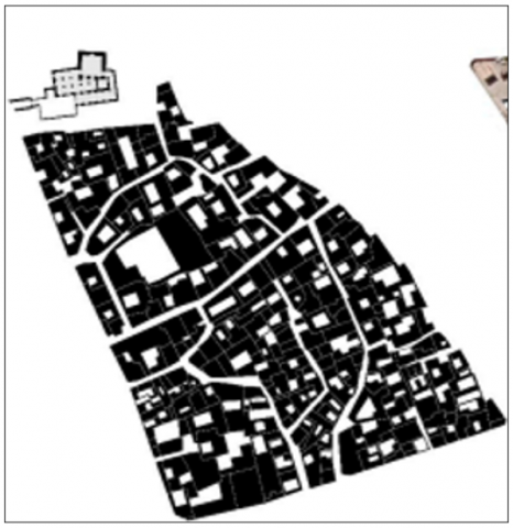
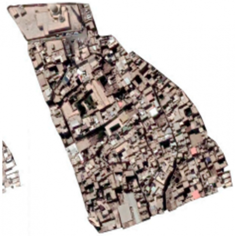
Aerial photographs are collected and the situation before and after the war is analysed using GPS (Figure 3). Aerial photographs of the urban fabric of the Al-Qalya’at neighbourhood were installed to assess the current state of the area after the destruction, comparing it to its pre-war condition. This data contributes to accurately documenting the current situation.
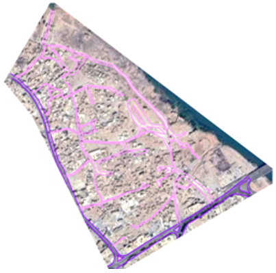
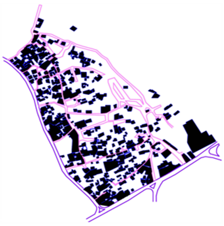
5.2 Mapping the movement network
Open and closed alleys within the neighbourhood’s urban fabric were identified using tools such as Network Analyst to analyse traffic and mobility. Relevant government agencies in Mosul were consulted for aerial photographs documenting the neighbourhood’s pre-war urban fabric. This process contributed to accurately mapping the movement network and reconstructing the movement paths that connected the different neighbourhoods.
5.3 Residential block modelling
Samples of the old residential style were selected and models of these blocks were designed using a collage technique, including the proportions of enclosure and openness for each block. Land uses and various functional types (residential, mosques, churches, and markets) were identified based on pre-war aerial photographs of the neighbourhood. This description provided a deep understanding of the area's urban structure.
5.4 Measuring accessibility
The extent of accessibility of residential areas to public services was assessed using buffer analysis, which allowed us to determine the distances between residential areas and vital facilities such as schools, hospitals, and markets. This step helps determine the effectiveness of the service network and the impact of reconstruction on public infrastructure.
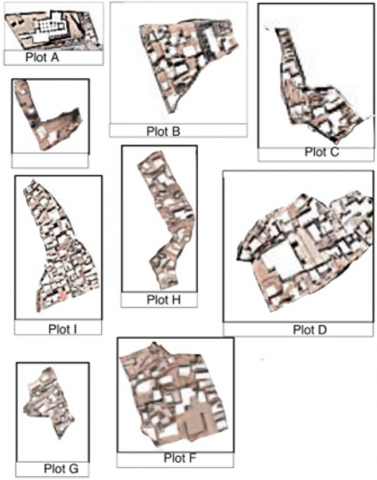
5.5 Sample selection
Six diverse samples of pre-war residential building styles were selected within the neighbourhood, identifying their characteristics, such as house plan shape, openness/closeness ratio, and clustering pattern. These samples were carefully selected to understand the urban diversity present in the area.
Figure 3. Documentation of the urban fabric of the area before and after the war
5.6 Residential block design
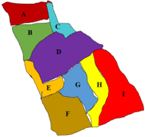
Each residential block (A-B-C-D-E-F-G-H-I) was designed separately, with open and closed alleys, house shapes, and interior spaces arranged according to their openness. This design allows for the reconfiguration of spaces to meet the demands of modern urban living.
5.7 Using the collage technique
The designed block models (A-B-C-D-E-F-G-H-I) were combined within the entire area using the collage technique, creating a testable urban model. This model allows for testing various architectural and functional hypotheses in the post-destruction phase, enhancing the scientific understanding of the reconstruction of the Al-Qalya’at neighbourhood in line with the needs of the population and contemporary developments. This application highlights how to use dynamic network analysis and coverage analysis tools to increase the effectiveness of post-war urban reconstruction in Mosul. Through aerial imagery analysis and careful documentation of the pre- and post-war urban fabric, life can be restored to the area in harmony with the old urban space. Modelling residential blocks using collage techniques also demonstrates researchers' ability to integrate traditional urban heritage with the contemporary requirements of rebuilding destroyed areas.
Figure 4. Stabilizing the internal movement network (open and dead-end alleys) of the old fabric
This stage focuses on improving the movement network within the old urban fabric, including open pathways and dead-end alleys, to enhance connectivity while preserving the area's historical character. Key aspects: Improving Access and Connectivity: Ensuring easy movement without compromising historical integrity, which may involve widening narrow alleys or reconfiguring dead-ends (Figure 4).
Figure 5. Stabilizing the remaining building masses within the old fabric
This stage ensures the structural stability of remaining buildings in the historical urban fabric through assessment, reinforcement, and preservation (Figure 5). Key aspects:
1. Structural Reinforcement: Assessing and strengthening buildings for stability.
2. Preservation: Maintaining the original architectural character during restoration.
3. Adaptation for Modern Use: Modifying buildings while preserving their integrity.
4. Deterioration Control: Repairing and preventing further decay.
5. Balancing Preservation and Development: Integrating old buildings into modern urban development.
The aim is to protect and stabilize historic buildings while allowing for future growth.
Figure 6. Stabilizing primary and secondary urban spaces within the old fabric
This phase centres on stabilizing and reintegrating primary and secondary urban spaces within the historic fabric of Mosul’s Old City, prioritizing the preservation of its cultural and architectural identity (Figure 6).
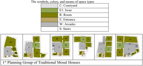
Figure 7. The six selected models
Documentation of housing typologies within the historic urban fabric adopts a context-sensitive planning approach that balances modern interventions with the inherited urban environment. A key component involves documenting and analysing six traditional houses and selected historical façades, examining their architectural typologies, spatial arrangements, and interaction with courtyards, alleys, and communal spaces. The selection of these six samples was based on the initial line of documentation proposed in Rana Mahfouz’s study (Figure 7), which emphasized their representative value in capturing the layered complexity and authenticity of Mosul’s historical fabric. The façades reveal the materiality, ornamentation, and construction techniques that shape the visual identity of the Old City, guiding reconstruction efforts toward respectful and integrated development [23].
Figure 8. Stabilizing land uses and functional activities
Within the Old Fabric This phase involves integrating and sustaining various land uses (such as residential, commercial, and services) within the historical urban fabric of the city. It also includes determining the functional activities that can align with and complement the old environment, while maintaining a balance between new uses and existing functions (Figure 8). This requires careful planning to ensure that modern activities do not negatively impact the historical character of the place but instead enhance its economic and social efficiency. The goal is to strike a balance between urban growth, modern living requirements, and the preservation of the cultural and architectural identity of the place.
Figure 9. Identifying the plot within the old fabric
This stage refers to the process of identifying and evaluating areas or elements that disrupt the historical urban fabric, often referred to as "blots." These blots may result from inappropriate developments or modern structures that lack harmony with the historical character of the area. The goal is to recognize these discordant elements and work on removing or modifying them to improve the integration between the old and new elements in the urban fabric (Figure 9).
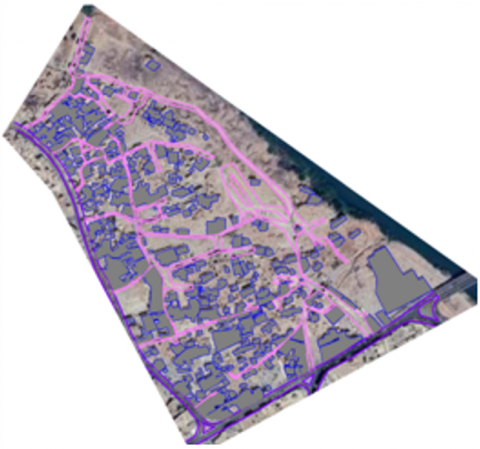
Figure 10. Degree of openness and closure
Figure 10 illustrates the distribution of urban masses and open spaces through a Figure-Ground diagram. The urban fabric appears dense and compact, with an irregular, organic street network, reflecting historical development. The diagram identifies major public spaces and the degree of openness and closure, aiding in understanding movement patterns and urban organization to enhance spatial integration and sustainable rehabilitation.
Figure 11. High-density
The model in Figure 11 represents a high-density urban cluster characterized by a compact urban fabric and a network of narrow, winding streets, reflecting a historical or traditional character that developed gradually without a regular grid plan. It indicates a pedestrian-oriented environment rather than one designed for vehicles, with a noticeable need to enhance public spaces and improve infrastructure to support sustainability and urban integration.
Figure 12. Urban analysis of Al-Midan area – A step toward sustainable reconstruction
The diagrams illustrate an initial analytical phase of the Al-Midan neighbourhood, part of a sustainable reconstruction strategy for a war-damaged area. The first map shows the current urban fabric and the distribution of damaged and remaining structures. The second map introduces a grid overlay used to analyse spatial relationships between buildings, alleys, and public spaces. This phase aims to understand the traditional fabric and identify intervention priorities—whether restoration, rebuilding, or integrating modern elements—while preserving the area's historical identity and supporting context-sensitive, sustainable redevelopment (Figure 12).
The accessibility index was calculated using ArcGIS's Network Analyst tool based on the actual road network and distribution of services such as schools, places of worship, recreational areas, and commercial hubs. To validate the model, results were cross-referenced with real-world data, including field surveys on pedestrian movement patterns, local traffic flow maps, and community access feedback collected through interviews with residents. The model was calibrated against baseline conditions derived from existing urban accessibility levels prior to the proposed planning interventions, where initial accessibility levels were estimated at approximately 45–50% for most internal areas. The reported 85% accessibility level refers specifically to areas adjacent to the main road network, with baseline accessibility in these zones previously measured at around 55%, showing a 30% relative improvement. Similarly, residential plot connection roads showed an increase from a baseline of 40% to 60%, indicating significant progress in intra-neighbourhood connectivity.
Accessibility thresholds—classified into high (70-100%), medium (40-69%), and low (below 40%)—were defined based on a combination of prior literature and adapted to local urban morphology and service distribution. These categories reflect the level of pedestrian and vehicular access to key public services within a 5–10-minute walking buffer zone, commonly used in urban design standards [24] (Figure 13).
Figure 13. Accessibility map of the area
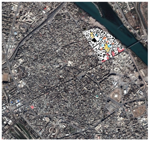
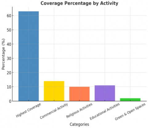
The model's accessibility index was measured using buffer analysis, where areas covered by activities and services, such as schools and parking lots, were identified to assess their inclusiveness within the model [25]. The quality of the distribution of facilities, which enhance urban vitality, was also assessed. The results showed that areas with good coverage represent a large proportion of the overall model. Residential activity achieved the highest coverage rate of 63%, followed by commercial activity at 14%. Religious and educational activities were close together, at 10% and 11%, respectively. The proportion of green and open spaces was 2%.
Figure 14. Land use distribution
The openness-enclosure ratio index of the model was measured using the Land Use Classification tool to determine the ratio of buildings, open spaces, and green areas—that is, to determine the level of openness-enclosure within the model. The results showed that the built-up area within the model amounted to 69%, while open spaces constituted 31% (Figure 14).
This research addressed the process of post-war city reconstruction from an architectural and philosophical perspective, integrating both the material and the spiritual dimensions of place. It highlighted the significance of the concept of the "daimon," or the guardian spirit of the place, which guides the process of rewriting and reshaping the urban fabric, so that the city is not seen merely as a physical space but as a living, layered text containing deep memory and identity.
The essence of reconstruction lies in the "rewriting of the city" through a critical and design-based approach that considers the intertwined relationship between history, memory, and cultural identity. This approach emphasizes the necessity of balancing the preservation of material and historical elements with the creation of new narratives that align with present and future needs.
Architectural design emerges as an interpretative process that helps give tangible presence to the absence of some physical elements, transforming voids and gaps into cultural symbols and living identities that resonate within the urban fabric. The integration of historical knowledge, philosophical insight, and practical design processes is key to reconstructing cities characterized by sustainability and cultural and social vitality.
The most important conclusions drawn from this research are as follows:
The proposed model relies on an efficient road network that achieves a balance between accessibility and privacy, ensuring balanced urban planning during the reconstruction phase. Accessibility analyses showed that road distribution provides comprehensive coverage, with improvements needed in secondary road connections to enhance internal connectivity. Allocating commercial activities along main roads contributes to maintaining continuous traffic flow, supporting the sustainability of economic activities and the efficient use of urban spaces.
The central distribution of religious activities, such as mosques and churches, creates functional focal points that facilitate access and integrate various land uses, thus enhancing cohesion and adding a functional dimension to urban planning. The road network is designed to serve these centers at the shortest possible travel distances, increasing land-use efficiency and ensuring that surrounding areas benefit.
Integrating educational planning with major transportation networks leads to an effective distribution of educational institutions. Coverage analyses revealed that schools located along main roads enjoy high accessibility, reducing travel times and achieving a balanced distribution of educational services. This approach is critical in reconstruction, ensuring optimal use of existing infrastructure and reducing the need for expanding road networks.
The rehabilitation of residential zones in the proposed model follows standards aimed at improving the quality of the urban environment, especially along the riverfront. The study demonstrated that intensifying residential activities in these areas maximizes the benefits of natural resources and supports an integrated urban vision. Open river views enhance land value and support sustainability strategies by optimizing the use of the local climate and natural lighting, thereby reducing dependence on artificial energy.
The planning model reflects a balance between built and open spaces that mimics the historical urban fabric while addressing the demands of modern reconstruction. Analyses of the openness/enclosure ratio indicated that retaining approximately 31% of open spaces supports natural ventilation and environmental integration while ensuring the urban density necessary for efficient land use. Designing these spaces according to sustainable standards contributes to improving quality of life and mitigating the urban heat island effect.
[1] UNESCO, ICCROM, and ICOMOS. (1994). The nara document on authenticity. https://www.icomos.org/en/charters-and-texts/179-articles-en-francais/ressources/charters-and-standards/386-the-nara.
[2] Saeed, Z.O., Almukhtar, A., Abanda, F.H., Tah, J.H.M. (2021). BIM applications in post-conflict contexts: The reconstruction of Mosul City. Buildings, 11(8): 351. https://doi.org/10.3390/buildings11080351
[3] Al-Muqdadi, F., Ahmed, A. (2022). Applying heritage building information modelling (HBIM) to lost heritage in conflict zones: Al-Hadba’ Minaret in Mosul, Iraq. The International Archives of the Photogrammetry, Remote Sensing and Spatial Information Sciences, XLIII-B2-2022: 753–760. https://doi.org/10.5194/isprs-archives-XLIII-B2-2022-753-2022
[4] Hammoodi, S.A., Al-Hinkawi, W.S. (2023). The role of spatial value in the reconstruction of religious buildings Mosul city: - A case study. Ain Shams Engineering Journal, 14(10): 102164. https://doi.org/10.1016/j.asej.2023.102164
[5] Mahdi, R.M., Aboud, A.H. (2021). Underground housing formation strategies. Journal of Physics: Conference Series, 1773: 012033. https://doi.org/10.1088/1742-6596/1773/1/012033
[6] Khoroufa, O.H. (2014). Urban regeneration policies according to sustainability approaches: An evaluation of historical cities – The case of Mosul. Al-Qadisiyah Journal for Engineering Sciences, 7(3): A105–A133.
[7] Iqbal, Y., Al-Hinkawi, W., Lafta, S. (2023). The role of historic building information modeling in the cultural resistance of liberated cities through digital documentation of historic buildings. Ain Shams Engineering Journal, 14(10): 102191. https://doi.org/10.1016/j.asej.2023.102191
[8] Almamouri, G.W., Al-Alwani, M.K. (2023). Developing a strategy for post-war cities reconstruction (the city of Mosul). AIP Conference Proceedings, 2769(1): 020002. https://doi.org/10.1063/5.0129369
[9] Al-Hafith, O., Satish, B.K., Bradbury, S., de Wilde, P. (2017). The impact of courtyard compact urban fabric on its shading: Case study of Mosul city, Iraq. Energy Procedia, 122: 889-894. https://doi.org/10.1016/j.egypro.2017.07.382
[10] Gutmann, J., Voigt, S. (2022). Testing Todd: Family types and development. Journal of Institutional Economics, 18(1): 101-118. https://doi.org/10.1017/S1744137421000175
[11] Aldewachi, M.H.D., Alkurukchi, M.A.M. (2018). The capability of Mosul's traditional dwellings to satisfy contemporary housing standards. In AlZarqa'a 2nd Engineering Scientific Conference, Alzarkaa, Jordan.
[12] Hillier, B. (1996). Space is the Machine. Cambridge University Press.
[13] Talee, S.M., Shareef, A.M. (2021). The design characteristics of the architectural elements in the houses of the old Mosul city—An analytical study of the Iwan element. Al-Rafidain Engineering Journal (AREJ), 26(2): 32-53. https://doi.org/10.33899/rengj.2021.129310.1079
[14] Mohammed, N., Mazin, R. (2025). Strategies for urban densification in the city of Baghdad – Kadhimiya: A case study. AIP Conference Proceedings, 3169: 040076. https://doi.org/10.1063/5.0256421
[15] Mühlbauer, L., Thiel, F. (2024). Aleppo and Mosul—Reconstruction with legal and urban development tools. In: Thiel, F., Orabi, R. (eds), Reviving Aleppo: Urban, Legal, and Digital Approaches for Post-War Recovery, pp. 45-68. Cham, Switzerland: Springer. https://doi.org/10.1007/978-3-031-65858-7_3
[16] Isakhan, B., Meskell, L. (2024). Rebuilding Mosul: Public opinion on foreign-led heritage reconstruction. Cooperation and Conflict, 59(3): 379-404. https://doi.org/10.1177/00108367231177796
[17] Majeed, A., Al-silk, G. (2023). A road map for the reconstruction of the old city of Mosul. Association of Arab Universities Journal of Engineering Sciences, 29(4): 1-14. https://doi.org/10.33261/jaaru.2023.29.4.001
[18] Mohammed, N., Mazin, R. (2025). Enhancing sensitive urban densification through infill development: A GIS analysis of vitality and integration in Jawaher Dijla residential compound, Iraq. AIP Conference Proceedings, 3169: 040068. https://doi.org/10.1063/5.0256153
[19] Koolhaas, R. (1978). Delirious New York. The Monacelli Press.
[20] Ali, S.H., Sherzad, M.F., Alomairi, A.H. (2022). Managing strategies to revitalize urban cultural heritage after wars: The center of the old city of Mosul as a case study. Buildings, 12(9): 1298. https://doi.org/10.3390/buildings12091298
[21] Al-Jaberi, A.A., Al-Khafaji, A.S.A., Al-Salam, N.A., Alrobaee, T.R. (2021). The crossing as a new approach for the urban transformation of traditional cities towards the sustainability. International Journal of Sustainable Development and Planning, 16(6): 1049-1059. https://doi.org/10.18280/ijsdp.160606
[22] Hussein, K.A., Ismaeel, E.H. (2021). Regenerating traditional houses facades of old Mosul city by Shape Grammar. Journal of the Faculty of Architecture, 18(2): 461-476. https://doi.org/10.5505/itujfa.2021.82788
[23] Mahfoodh, R., Aksulu, B.I. (2024). Reasons and results of social and physical changes in traditional Mosul houses between 2014-2023. International Journal of Sustainable Development and Planning, 19(2): 403-419. https://doi.org/10.18280/ijsdp.190201
[24] Chizzoniti, D.G., Lolli, T. (2023). Urban morphology, identity, heritage, and reconstruction processes in Middle East post-war scenarios: The case of Mosul Old City. Land, 12(12): 2140. https://doi.org/10.3390/land12122140
[25] UN-Habitat. (2019). The initial planning framework for the reconstruction of Mosul. United Nations. https://unhabitat.org/the-initial-planning-framework-for-the-reconstruction-of-mosul-0.