Yetondé Deton*![]() | Hodabalo Kamou
| Hodabalo Kamou![]() | Abalo Atato
| Abalo Atato![]() | Joseph Yoka
| Joseph Yoka![]() | Marra Dourma
| Marra Dourma![]() | Kudzo Atsu Guelly
| Kudzo Atsu Guelly![]() | Komlan Batawila
| Komlan Batawila![]() | Koffi Akpagana
| Koffi Akpagana![]()
© 2025 The authors. This article is published by IIETA and is licensed under the CC BY 4.0 license (http://creativecommons.org/licenses/by/4.0/).
OPEN ACCESS
Urbanization is accelerating on a global scale, thereby exerting increasing environmental pressures on cities. Consequently, the preservation of urban green spaces (UGS) has become a priority for ensuring urban sustainability. However, in many cities of the Global South, unchecked horizontal expansion is leading to a significant reduction in these spaces, thereby threatening their ecological and social functions. This study investigates local perceptions of ecosystem services (ESs) provided by UGS in Lomé and Kara, Togo, using participatory mapping integrated with Geographic Information Systems (GIS), and also examines the influence of sociocultural factors on these perceptions. Data were collected across various districts through structured interviews with socio-cultural and ethnic stakeholders, involving 318 respondents in Lomé and 184 in Kara. Statistical analyses were conducted using Minitab and Canoco 4.5. The results identified 137 UGS in Lomé and 97 in Kara. In Lomé, regulating services (39.1%) and sociocultural services (37.3%) were the most valued, whereas in Kara, sociocultural services (37.4%) and supporting services (18%) were predominant. Furthermore, variations in perception were found to be strongly influenced by ethnicity, age, and educational level, with younger and more educated respondents demonstrating heightened environmental awareness. The findings emphasise the urgent need for a differentiated management approach tailored to local realities and for the active involvement of citizens in urban planning, enhancing UGS governance requires stronger regulations to prevent encroachment, integrating participatory mapping into urban planning, and promoting incentives for UGS preservation. Additionally, boosting environmental education and public awareness is essential for long-term civic engagement and sustainable management. Participatory approaches have been shown to strengthen UGS governance and inform inclusive and sustainable policies, providing exemplary perspectives for resilient urbanization. The study emphasises the necessity of implementing innovative and effective urban strategies to counteract the progressive loss of UGS in rapidly expanding African cities.
urban green spaces (UGS), ecosystem services (ESs), participatory mapping, citizen perception, Lomé, Kara
Urban green spaces (UGS) are increasingly recognized for their critical contribution to urban sustainability worldwide, primarily due to their role in providing essential ecosystem services (ESs). These services, whether regulatory, supporting, provisioning, or cultural, enhance urban populations’ well-being and mitigate the impacts of climate change [1]. According to the Millennium Ecosystem Assessment (MEA) report [2], ESs encompass both material and non-material benefits derived from ecosystems. Numerous studies have underscored their importance, emphasizing the broad spectrum of ESs they offer [1, 3-5].
UGS play a vital role in improving air [6, 7] and water quality [8], regulating local climate by mitigating urban heat islands [9-13], and fostering physical, intellectual, and psychological well-being [14-18] by providing recreational and social interaction spaces [19]. Furthermore, they supply essential resources such as food, water, fiber, and fuel, while contributing to soil stabilization, thereby reducing the risks of natural disasters such as flooding [20, 21]. UGS also serve as key carbon sinks, capturing emissions from industrial activities, vehicular traffic, unmanaged waste disposal sites, and other greenhouse gas sources [22], ultimately helping to mitigate global climate change effects [23].
However, public perception of these services varies based on socio-economic and cultural factors, influencing both the management and conservation of UGS [24-26]. Recent studies [27, 28] highlight the role of citizen engagement in reinforcing sustainable green space management policies, stressing the necessity of involving local populations in identifying and valuing ESs. Moreover, a positive perception of ESs among urban dwellers can serve as a powerful driver for fostering conservation-oriented behaviours and promoting the expansion of UGS, contributing to urban resilience. In the context of rapid urbanization and increasing environmental pressures, the preservation and development of green spaces represent a major challenge for cities in the Global South, particularly in Africa.
In African cities, rapid and often unplanned urban expansion has led to the degradation of urban ecosystems and the marginalization of vulnerable populations in terms of green space accessibility [29]. Addressing fragmentation and ensuring local inclusion in green space management is crucial for maintaining ESs. Inclusive approaches, such as participatory mapping [30], are key to achieving equitable and sustainable urban ecosystem management. This method combines Geographic Information Systems (GIS) with qualitative data from local communities and other stakeholders involved in UGS governance, enabling a better understanding of land management and natural resource challenges [30-35].
In Togo, the cities of Lomé and Kara host significant green spaces that provide valuable ESs. While several studies have examined the role of UGS, the ESs they offer, and the influence of public perception on their sustainable management [36-41], participatory approaches remain underexplored. This study bridges this gap by integrating local perceptions with a participatory approach to deepen the understanding of socio-environmental dynamics related to ESs in Togolese cities. It investigates how residents of Lomé and Kara perceive ESs, hypothesizing that perceptions and access to these services vary according to socio-spatial contexts, ultimately shaping urban planning strategies. Through a comparative approach, the study provides insights for a more inclusive and sustainable UGS management in Togo, ensuring the long-term provision of ESs.
This study aims to enhance the understanding of UGS to support the sustainable management of the ESs they provide. Specifically, it seeks to: (i) map the green spaces of Lomé and Kara through active community involvement and (ii) assess public perceptions regarding UGS management and urban ESs. Findings from this participatory approach will serve as a foundation for policies and projects aimed at ensuring sustainable UGS management in highly urbanized areas.
2.1 Study area
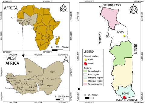
The study was conducted in Togo’s two main cities: Lomé and Kara (Figure 1).
Figure 1. Geographical location of the study area within the different regions of Togo and its positioning within the African context
Lomé, the capital, is located in the extreme south within the Maritime Region. It is bordered by the Atlantic Ocean to the south, Ghana to the west, and the Zio and Lacs prefectures to the north and east, respectively. The city comprises 13 municipalities spanning the Agoè-Nyivé and Golfe prefectures. Situated within Ecological Zone V, where humid forests have nearly vanished and been replaced by sparse green spaces, Lomé experiences a sub-equatorial climate with an annual bimodal rainfall pattern of approximately 800 mm. The city's soils are predominantly sandy and clayey. Lomé is a multicultural metropolis, primarily inhabited by the Ewe ethnic group, with a rapidly growing population of 2,188,376 in 2022, accounting for 63% of the country’s urbanization rate [42].
Kara, located over 400 km north of Lomé, serves as the administrative center of the Kozah Prefecture and comprises three municipalities (Kozah 1, 2, and 3) (Figure 1). It falls within Ecological Zone II, characterized by the disappearance of dry forests, leaving behind a fragmented vegetation landscape. The city experiences a Sudanian tropical climate with a unimodal rainfall regime, receiving between 1,100 and 1,700 mm of precipitation annually. The predominant soil types are ferruginous and weakly developed [43]. As of the 2022 census, Kara’s population was estimated at 158,090 [42], with major ethnic groups including the Kabyè, Kotokoli, Adza-Ewé, and Lamba.
2.2 Data collection
The participatory GIS (PGIS) method was employed to map green spaces and assess urban residents' knowledge of these areas and their associated ESs. This approach follows four main steps, as adopted by several authors [33, 35, 44-46].
2.2.1 Step 1: Preparation phase
This phase involved gathering all relevant information and data on the study areas. For each city, shapefiles of the different municipalities with their administrative units were overlaid onto Google Maps images using QGIS software to obtain the spatial configuration of various land use forms. To enhance the transparency of neighborhood selection, the identification of areas to be surveyed was based on a combination of high-resolution satellite images from Google Earth and municipal data on UGS. The spatial distribution of UGS within each municipality of Lomé and Kara was analyzed, allowing for an objective selection of neighborhoods in proximity to these spaces. By cross-referencing satellite imagery with municipal records, we ensured a systematic and representative sampling approach, eliminating potential selection biases and ensuring comprehensive spatial coverage.
Subsequently, meetings were held with local municipal authorities, who serve as key stakeholders (mayors, municipal agents, neighbourhood or district chiefs, and CDQ representatives), to inform them about the participatory GIS approach and to establish a team of local cartographers [33, 35]. To ensure the reliability and accuracy of spatial data collection, the selection of local cartographers was rigorous, prioritizing individuals with in-depth and practical knowledge of their local environment, particularly those with prior experience in community-based mapping or land-use planning. The socio-spatial diagnostic process actively involved local stakeholders. The local cartography team was constituted with the approval of municipal officials (municipal agents, district chiefs, neighbourhood chiefs, CDQ representatives). These participants, comprising both genders, were physically fit, literate (able to read and write), young (20–60 years old), honest, and sociable. They were residents of the surveyed cities and possessed in-depth knowledge of their physical environments. They were trained in spatial data collection techniques, with a focus on scale concepts, map reading and legend interpretation, and GPS usage.
2.2.2 Step 2: Data collection
1) Selection criteria for respondents
The selection of respondents was conducted randomly, based on their proximity to UGS. During the preparatory phase, it was observed that in Lomé, the majority of the population residing near UGSs belongs to the Ewe ethnic group, whereas in Kara, the predominant ethnic group is the Kabyè. However, individuals from other ethnic backgrounds were also included in the survey, as they equally benefit from these green spaces.
2) Formation of discussion groups
Within each municipality of both cities, semi-structured surveys were conducted through individual interviews and focus group discussions. These interviews were administered to key local stakeholders, including municipal mayors, professionals in the field, and residents living adjacent to the identified green spaces. The survey covered several aspects, including respondents’ demographic characteristics (gender, ethnicity, educational level, and occupation), their knowledge of UGS (types, management approaches, and accessibility), and the ESs these spaces provide.
3) Participatory mapping
Participants began by delineating the boundaries of their respective municipalities, marking major pathways in their localities, and identifying key reference points such as the town hall, the canton chief’s residence, churches/mosques, roads, administrative buildings, schools, hospitals, markets, and, most importantly, UGS (Figure 2).
Figure 2. Data collection and development of the participatory map in the cities of Lomé (a—Golfe 6 Municipality, b—Golfe 3 Municipality, c—Agoè-Nyivé 4 Municipality) and Kara (d—Kozah 1 Municipality)
4) Preliminary validation
Areas of interest, including green spaces, pathways, and significant sites, were georeferenced using GPS in the field.
5) Data digitization
The collected data were processed upon returning from the field and validated in collaboration with community members. To further refine data quality, a three-step verification process was implemented: (1) field data were manually checked against GPS coordinates to detect inconsistencies, (2) digital maps were overlaid with satellite imagery to validate spatial accuracy, and (3) local stakeholders participated in validation workshops where they reviewed and confirmed the final dataset. Any identified errors were corrected before finalizing the maps. This participatory approach ensured that any inconsistencies were corrected before finalizing the dataset.
2.2.3 Step 3: Validation and finalization of the map
Following these refinements, the schematic maps were submitted for approval to a representative group of community members whose territories were mapped. To strengthen the validation process, participatory feedback sessions were conducted, where local stakeholders assessed the accuracy of mapped features based on their real-world knowledge. Where available, the final maps were cross-referenced with official cadastral and municipal land-use records to ensure consistency between participatory and official spatial data. To facilitate validation, the maps derived from cartographic data based on satellite imagery served as a reference for discussions with local stakeholders from the various municipalities (Figure 3).
Figure 3. Validation of the participatory mapping of UGS in the cities of Lomé (a – Golfe 6 Municipality) and Kara (b – Kozah 1 Municipality)
2.2.4 Step 4. Processing and analysis of survey data
The survey data collected were exported to Excel and processed using Minitab and Canoco 4.5 software to elucidate urban residents' local perceptions of UGS.
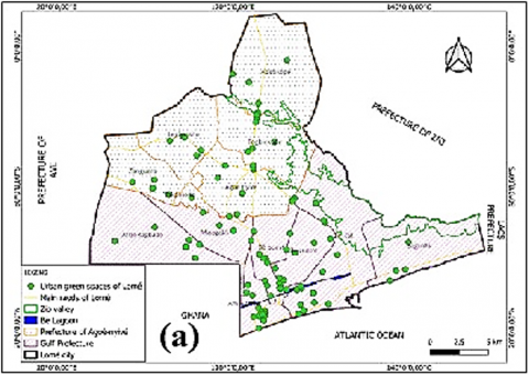
3.1 Participatory mapping of green spaces in the cities of Lomé and Kara
The PGIS facilitated the identification and mapping of 137 green spaces within the municipalities of Lomé (Figure 4a) and 97 green spaces within those of Kara (Figure 4b).
Figure 4. Participatory maps of green spaces in Lomé (a) and Kara (b) cities
3.2 Local perception of urban ecosystem services provided by green spaces
3.2.1 Profile of respondents
In Lomé, a total of 318 individuals participated in the survey, representing 20 ethnics groups, including 96 women and 222 men (Table 1). The most represented ethnic groups were the Ewé (80.19%), followed by the Kabyè (8.49%) and the Moba (2.20%).
Similarly, in Kara (Table 2), a total of 272 respondents were surveyed, representing 9 ethnic groups. The most represented ethnic groups were the Kabyè (67.65%), Bassar (10.29%), Kotokoli (5.88%), and Ifè (5.88%). As observed in Lomé, men (166) were more represented than women (106).
A statistical analysis using Tukey’s test was conducted to assess potential significant differences between groups. The results revealed no statistically significant difference in the gender distribution of respondents in Lomé (F = 99 ± 10.57; H = 219 ± 12.40) and Kara (F = 67 ± 17.2; H = 172 ± 12.40). Similarly, no significant difference was detected concerning respondents' age in both cities (P = 0.090 in Lomé with F = 2.90; P = 0.085 in Kara with F = 1.45).
The mean age was 28.98 ± 19.04 years in Lomé and 29.75 ± 12.04 years in Kara, with a slight tendency toward a lower mean age among women. In Lomé, the average age for women was 27.30 ± 9.74 years, compared to 29.74 ± 13.18 years for men. In Kara, women had a mean age of 22.78 ± 11.99 years, while men averaged 26.41 ± 12.63 years.
These findings suggest a demographic homogeneity between Lomé and Kara, with no notable distinction in terms of age or gender distribution. Although women exhibited a slightly lower mean age than men in both cities, this difference was not statistically significant, indicating that it may result from random variability or contextual factors not accounted for in this study. Further sociological analysis could provide deeper insights into this trend.
Table 1. Socio-demographic profile of respondents in the city of Lomé
|
Ethnic Groups |
Female Gender |
Male Gender |
Grand Total |
Percentage (%) |
||||||
|
Young People |
Adults |
Older People |
F Total |
Young People |
Adults |
Older People |
M Total |
|||
|
Ewé |
38 |
44 |
4 |
86 |
79 |
78 |
12 |
169 |
255 |
80.19 |
|
Kabyè |
1 |
2 |
0 |
3 |
17 |
6 |
1 |
24 |
27 |
8.49 |
|
Moba |
0 |
0 |
0 |
0 |
2 |
5 |
0 |
7 |
7 |
2.20 |
|
Haoussa |
1 |
0 |
0 |
1 |
0 |
3 |
0 |
3 |
4 |
1.26 |
|
Nawda |
0 |
0 |
0 |
0 |
3 |
1 |
0 |
4 |
4 |
1.26 |
|
Tem |
2 |
0 |
0 |
2 |
1 |
0 |
0 |
1 |
3 |
0.94 |
|
Adja |
0 |
0 |
0 |
0 |
1 |
1 |
0 |
2 |
2 |
0.63 |
|
Konkomba |
0 |
0 |
0 |
0 |
1 |
1 |
0 |
2 |
2 |
0.63 |
|
kotokoli |
0 |
0 |
0 |
0 |
1 |
0 |
1 |
2 |
2 |
0.63 |
|
Tchokossi |
0 |
0 |
0 |
0 |
2 |
0 |
0 |
2 |
2 |
0.63 |
|
Adibo |
1 |
0 |
0 |
1 |
0 |
0 |
0 |
0 |
1 |
0.31 |
|
Akposso |
0 |
0 |
0 |
0 |
0 |
1 |
0 |
1 |
1 |
0.31 |
|
Ana |
0 |
0 |
0 |
0 |
1 |
0 |
0 |
1 |
1 |
0.31 |
|
Anago |
0 |
0 |
0 |
0 |
0 |
1 |
0 |
1 |
1 |
0.31 |
|
Bassar |
0 |
0 |
0 |
0 |
0 |
1 |
0 |
1 |
1 |
0.31 |
|
Fon |
0 |
0 |
0 |
0 |
0 |
1 |
0 |
1 |
1 |
0.31 |
|
Ifè |
0 |
1 |
0 |
1 |
0 |
0 |
0 |
0 |
1 |
0.31 |
|
Lamba |
1 |
0 |
0 |
1 |
0 |
0 |
0 |
0 |
1 |
0.31 |
|
Sango |
0 |
1 |
0 |
1 |
0 |
0 |
0 |
0 |
1 |
0.31 |
|
Watchi |
0 |
0 |
0 |
0 |
1 |
0 |
0 |
1 |
1 |
0.31 |
|
Grand Total |
44 |
48 |
4 |
96 |
109 |
99 |
14 |
222 |
318 |
100.00 |
Table 2. Socio-demographic profile of respondents in the City of Kara
|
Ethnic Groups |
Female Gender |
Male Gender |
Grand Total |
Percentage (%) |
||||||
|
Young People |
Adults |
Older People |
Total |
Young People |
Adults |
Older People |
Total |
|||
|
Kabyè |
47 |
11 |
22 |
80 |
72 |
8 |
24 |
104 |
184 |
67.65 |
|
Bassar |
4 |
0 |
4 |
8 |
12 |
0 |
8 |
20 |
28 |
10.29 |
|
Kotokoli |
4 |
1 |
1 |
6 |
8 |
1 |
1 |
10 |
16 |
5.88 |
|
Ifè |
4 |
0 |
0 |
4 |
7 |
0 |
5 |
12 |
16 |
5.88 |
|
Akposso |
2 |
0 |
2 |
4 |
2 |
0 |
2 |
4 |
8 |
2.94 |
|
Konkomba |
0 |
0 |
0 |
0 |
0 |
0 |
8 |
8 |
8 |
2.94 |
|
Ewé |
0 |
0 |
0 |
0 |
2 |
2 |
0 |
4 |
4 |
1.47 |
|
Lamba |
0 |
0 |
0 |
0 |
2 |
0 |
2 |
4 |
4 |
1.47 |
|
Moba |
0 |
0 |
4 |
4 |
0 |
0 |
0 |
0 |
4 |
1.47 |
|
Grand Total |
61 |
12 |
33 |
106 |
105 |
11 |
50 |
166 |
272 |
100.00 |
3.2.2 Ecosystem services provided by green spaces in Lomé and Kara
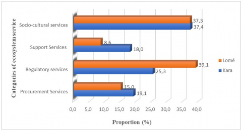
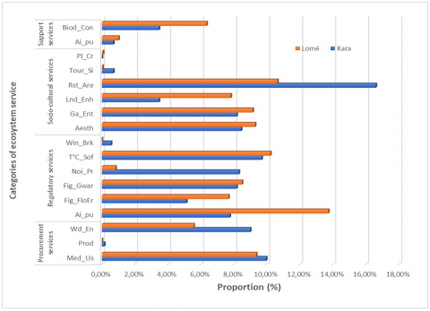
Urban residents in Lomé prioritized regulatory services (39.1%) (Figure 5), particularly in response to urban environmental challenges such as climate regulation and noise reduction. Socio-cultural services (37.3%) were also highly valued, particularly aesthetic improvement (Aesth) and landscape enhancement (Lnd_Enh) (Figure 6). However, supporting services (8.6%) and provisioning services (15%) were less recognized, despite the specific appreciation of medicinal plant use (Med_Us).
In Kara, socio-cultural services (37.4%) were the most valued (Figure 5), particularly for recreational activities such as tourism and food-related spaces (Rst_Are) (Figure 6). Supporting services (18%), including biodiversity conservation (Biod_Con), were also well recognized, indicating heightened ecological awareness. Regulatory (25.3%) and provisioning services (19.1%) were also acknowledged, with flood risk management (Fig_FloEr) being particularly emphasized due to local climate concerns.
Figure 5. Distribution of perceived ESs types by urban residents
Figure 6. Specific priorities of ESs by functional category
3.2.3 Perception of ecosystem services based on sociocultural criteria (ethnicity, age, and education level) in Lomé and Kara
The assessment of the perception of ESs provided by UGS across different sociocultural criteria (ethnicity, age, and educational level) was conducted using a multivariate analysis (Figures 7 and 8). Redundancy analysis (RDA) was employed to evaluate model fit and identify potential significant differences among the examined parameters. This test also ensured the homogeneity of variance in ES perceptions across different ethnic groups, thereby reinforcing the robustness of the findings. Additionally, an analysis of variance (ANOVA) was performed to assess the normality of residuals, further validating the statistical reliability of the analyses.
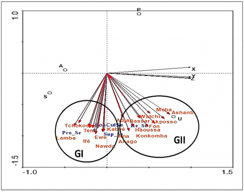
Figure 7. Perceptions of ESs provided by green spaces according to the sociocultural criteria of Lomé's urban residents on the factorial plane 1-2 of the Redundancy Analysis (RDA)
Pro_S e = Procurement services, Socul_Se = Socio-cultural services, Re_Se = Regulatory services, Sup_Se = Support services; X, Y, and Z represent age groups (X = [18–25 years], Y = ]25–50 years], Z ≥ 50 years); A, P, S, and U correspond to educational levels (A = Illiterate, P = Primary, S = Secondary, U = University)
Figure 8. Perceptions of ESs provided by green spaces according to the sociocultural criteria of Kara's urban residents on the factorial plane 1-2 of the Redundancy Analysis (RDA)
The analysis of Figure 7 highlights two major groups in the perception of ESs provided by UGS in Lomé. Group GI, primarily composed of the Ewé, Kabiyè, Nawda, Tem, and Tchokossi ethnic groups, assigns high value to socio-cultural (SoCu_Se) and supporting services (Sup_Se), emphasizing the role of green spaces in education and social cohesion. This group is predominantly represented by young individuals (18–25 years old) and those with university-level education, suggesting a heightened awareness of the social and cultural benefits of green spaces.
Group GII, consisting mainly of the Moba, Ashanti, and Watchi ethnic groups, adopts a more utilitarian perspective on green spaces, prioritizing provisioning (Pro_Se) and regulating services (Re_Se). This perception is more pronounced among middle-aged adults (25–50 years old) and individuals with primary or secondary education, reflecting a pragmatic approach to ES driven by immediate economic and climatic needs. Seniors (50 years and older) primarily associate green spaces with supporting services, indicating a long-term environmental perspective.
The analysis of Figure 8 reveals a marked differentiation in the perception of UGS ESs in Kara based on sociocultural groups. The Konkomba and individuals with primary or secondary education (GI) exhibit a limited recognition of ESs, whereas the Ewé, Tem, Ifè, and Akposso (GII) prioritize provisioning (Pro_Se) and regulatory services (Re_Se), reflecting a reliance on the immediate benefits of green spaces.
Furthermore, young adults (18–25 years) tend to favor utilitarian services, while middle-aged adults (25–50 years) adopt a more balanced perspective, integrating both ecological and cultural dimensions.
The Bassar and university graduates (GIII) place greater emphasis on supporting services (Sup_Se), indicating a heightened awareness of long-term environmental benefits. Conversely, the Lamba and Kabyè (GIV) highly value socio-cultural services (SoCu_Se), underscoring the role of green spaces in social cohesion and cultural traditions.
The use of redundancy analysis was instrumental in validating the model's quality and identifying potential disparities among sociocultural groups. The absence of major biases in variance homogeneity confirms that the observed differences are structural rather than statistical artifacts. These findings suggest that integrating sociocultural dimensions into UGS planning policies could enhance their acceptance and foster more sustainable management practices.
3.2.4 Green space management and planning
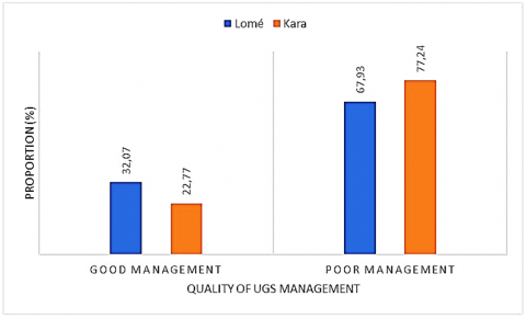
Figure 9 indicates that in Lomé, 32.07% of respondents rated the management of UGS as good, compared to only 22.77% in Kara. However, the majority perceived management as poor, with 67.93% in Lomé and 77.24% in Kara. These results reveal common governance challenges in both cities, necessitating improvements in UGS management policies.
Figure 9. Perceived quality of UGS management in Lomé and Kara
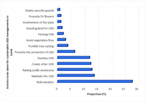
Figure 10 highlights the priorities for sustainable UGS management in Lomé. Reforestation emerged as the primary action (~30%), followed by UGS maintenance (~20%) and public awareness (~15%).
These priorities underscore a strong interest in green space restoration and conservation, while actions such as monitoring and security were less frequently mentioned.
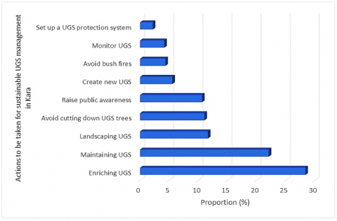
In Kara, Figure 11 shows that "enhancing UGS" (~30%) and "maintaining UGS" (~20%) were the most recommended actions. Measures such as public awareness campaigns and tree protection indicate growing attention to participatory management and green space conservation. However, institutional actions such as implementing protection systems remained a lower priority.
Figure 10. Proposed actions for sustainable management of UGS in Lomé
Figure 11. Proposed actions for sustainable management of UGS in Kara
4.1 Perception and contribution of ugs to ecosystem services: Spatial and sociocultural influences
The findings of this study highlight the crucial role of UGS in providing ESs in the Togolese cities of Lomé and Kara. These UGS not only fulfill ecological functions but also play a significant sociocultural role, corroborating the conclusions of similar studies conducted in comparable urban contexts [1, 7, 19, 47]. The predominance of regulating and sociocultural services observed in Lomé and Kara reflects a growing awareness among urban dwellers regarding the environmental and social benefits provided by these spaces. However, the limited perception of supporting and provisioning services, particularly in Lomé, indicates gaps in valuing essential functions such as biodiversity conservation and the supply of natural resources, as previously reported by Oosterbroek et al. [48].
Perception differences between Lomé and Kara reveal specific socio-environmental dynamics in each city. In Lomé, the prioritization of regulating services (39.1%) can be attributed to the urgent need to address urban environmental challenges, such as air pollution and urban heat islands [6, 12, 13, 49]. In contrast, in Kara, urban dwellers place greater emphasis on supporting services (18%), particularly biodiversity conservation. This discrepancy may be linked to Kara residents' relative proximity to natural resources and their direct interaction with the environment [29, 50]. These findings confirm that local contexts influence priorities in green space management, as previously emphasized by Lee and Kim [50] and Meyer-GrandBastien et al. [51].
The analysis of sociocultural criteria reveals significant disparities in ES perception based on ethnicity, education level, and age. For instance, in Lomé, the majority Ewe ethnic group prioritizes sociocultural and regulating services, whereas in Kara, the Kabye population places greater value on biodiversity conservation and flood management services. These variations confirm that cultural contexts influence how urban populations perceive the benefits of green spaces, a finding consistent with previous studies on ES perception in African cities [28, 32]. Moreover, age and education level appear to play a decisive role: younger, more educated urban dwellers demonstrate a better understanding of environmental challenges and a higher recognition of ES value. These observations support the findings of previous studies [26, 48], which highlight environmental awareness and education as key drivers for enhancing citizen engagement.
4.2 Contributions of participatory mapping and implications for urban planning
The participatory approach adopted in this study helped bridge the gaps of top-down strategies, often criticized in African UGS management [30, 32]. By actively involving local communities, participatory mapping not only enhanced citizens' knowledge of their UGS but also revealed elements that conventional analyses often overlook, such as micro-local perceptions of ESs. Furthermore, this approach fostered community ownership of the results, which is essential for ensuring the sustainability of UGS management policies [35]. These findings confirm the effectiveness of this method, which has been widely recognized for improving land and natural resource management [31, 33].
The results of this study provide strategic guidelines for a more inclusive and sustainable management of UGS in Togolese cities. First, recognizing disparities in ES perception across socio-spatial contexts should guide urban planning efforts. In this regard, differentiated management approaches tailored to local priorities (regulation in Lomé, support and sociocultural services in Kara) appear essential. Second, the active involvement of local populations, as demonstrated through participatory mapping, should be institutionalized within urban governance processes. Finally, environmental education and awareness programs, particularly targeting young people and vulnerable groups, should be strengthened to sustain UGS benefits and encourage their conservation.
4.3 Limitations and perspectives
Although this study illustrates the importance of an inclusive and context-specific approach to UGS management for enhancing climate resilience and urban well-being in Togo, certain limitations remain. The analysis is primarily based on subjective perceptions, which may introduce biases in data interpretation. Additionally, while qualitative tools provide valuable insights, their integration with quantitative approaches would enhance the assessment of ESs. Future long-term studies could be undertaken to measure the evolution of perceptions and their actual impact on the sustainability of green space management policies. Integrating citizen perceptions into conservation policies represents a significant advancement toward sustainable urbanization in African cities.
This study highlights the potential of participatory approaches to enhance the conservation and valorisation of UGS in Togolese cities. It demonstrates that citizen perceptions, combined with tools such as participatory mapping, are key drivers for improving management strategies and strengthening the climate resilience of green spaces. By integrating insights from the literature with local specificities, this research proposes concrete solutions for sustainable urban planning in Lomé and Kara, paving the way for similar initiatives in other African urban contexts.
We extend our sincere gratitude to the Regional Centre of Excellence on Sustainable Cities in Africa at the University of Lomé and its partner, the World Bank, for their invaluable financial support in conducting this research. Our deepest appreciation goes to the municipal authorities of Lomé and Kara, whose collaboration and support were instrumental in facilitating this study. We are also profoundly grateful to community leaders, and local stakeholders for their insightful contributions and unwavering availability. Special thanks are due to the citizens of Lomé and Kara, who generously shared their experiences and perspectives, significantly enriching this research. Finally, we acknowledge the dedication and commitment of the research teams and field assistants, whose meticulous efforts made the data collection process possible.
This work is supported by Regional Centre of Excellence on Sustainable Cities in Africa (CERViDA_DOUNEDON), the Association of African Universities (AUA) and the World Bank (Grant number IDA 5360 TG).
[1] Grunewald, K., Bastian, O. (2017). Special Issue: “Maintaining ecosystem services to support urban needs”. Sustainability, 9(9): 1647. https://doi.org/10.3390/su9091647
[2] Millennium Ecosystem Assessment, M.E.A. (2005). Ecosystems and Human Well-Being. Washington, DC: Island Press.
[3] Szumacher, I., Pabjanek, P. (2017). Temporal changes in ecosystem services in European cities in the continental biogeographical region in the period from 1990–2012. Sustainability, 9(4): 665. https://doi.org/10.3390/su9040665
[4] Kang, W., Chon, J., Kim, G. (2020). Urban ecosystem services: A review of the knowledge components and evolution in the 2010s. Sustainability, 12(23): 9839. https://doi.org/10.3390/su12239839
[5] Muñoz-Pacheco, C.B., Villaseñor, N.R. (2022). Urban ecosystem services in South America: A systematic review. Sustainability, 14(17): 10751. https://doi.org/10.3390/su141710751
[6] Selmi, W., Weber, C., Rivière, E., Blond, N., Mehdi, L., Nowak, D. (2016). Air pollution removal by trees in public green spaces in Strasbourg city, France. Urban Forestry & Urban Greening, 17: 192-201. https://doi.org/10.1016/j.ufug.2016.04.010
[7] Xie, Q., Yue, Y., Sun, Q., Chen, S., Lee, S.B., Kim, S.W. (2019). Assessment of ecosystem service values of urban parks in improving air quality: A case study of Wuhan, China. Sustainability, 11(22): 6519. https://doi.org/10.3390/su11226519
[8] Neeti, K., Singh, R., Kumar, A. (2024). Plant-based approaches for wastewater management: A comprehensive review of phytoremediation techniques. Proceedings, 102(1): 41. https://doi.org/10.3390/proceedings2024102041
[9] Zoungrana, S.S., Ganaba, S., Ouoba, P., Tiendrebeogo, R.N. (2021). Diversité végétale et effet sur la température des infrastructures vertes urbaines de Bobo-Dioulasso (Burkina Faso). Sciences Naturelles et Appliquées, 40(2): 10-22.
[10] Gherri, B. (2023). The role of urban vegetation in counteracting overheating in different urban textures. Land, 12(12): 2100. https://doi.org/10.3390/land12122100
[11] Syrbe, R.U., Meier, S., Moyzes, M., Dworczyk, C., Grunewald, K. (2024). Assessment and monitoring of local climate regulation in cities by green infrastructure—A national ecosystem service indicator for Germany. Land, 13(5): 689. https://doi.org/10.3390/land13050689
[12] Senosiain, J.L. (2020). Urban regreeneration: Green urban infrastructure as a response to climate change mitigation and adaptation. International Journal of Design & Nature and Ecodynamics, 15(1): 33-38. https://doi.org/10.18280/ijdne.150105
[13] Lu, S., Kong, L., Liu, Y., Zhang, Q., Zhang, D., Wang, M. (2024). Refined assessment of thermodynamic effects of urban green spaces based on GIS technology and optimization of their layout strategy. International Journal of Heat & Technology, 42(6): 2008-2018. https://doi.org/10.18280/ijht.420618
[14] Gascon, M., Triguero-Mas, M., Martínez, D., Dadvand, P., Rojas-Rueda, D., Plasència, A., Nieuwenhuijsen, M.J. (2016). Residential green spaces and mortality: A systematic review. Environment International, 86: 60-67. https://doi.org/10.1016/j.envint.2015.10.013
[15] Van den Bosch, M., Sang, Å.O. (2017). Urban natural environments as nature-based solutions for improved public health–A systematic review of reviews. Environmental Research, 158: 373-384. https://doi.org/10.1016/j.envres.2017.05.040
[16] Kondo, M.C., Fluehr, J.M., McKeon, T., Branas, C.C. (2018). Urban green space and its impact on human health. International Journal of Environmental Research and Public Health, 15(3): 445. https://doi.org/10.3390/ijerph15030445
[17] Yuniarti, E., Damanik, F.H.S., Dewata, I., Nugraha, F.A.D. (2024). Urban green space as a solution for degenerative diseases: A perspective based on a literature review. International Journal of Sustainable Development and Planning, 19(4): 1271-1279. https://doi.org/10.18280/ijsdp.190405
[18] Muzakir, M., Wahyuningsih, W., Ponirin, P. (2024). Measurement model of sustainable servicescape and service quality on green space and environmental satisfaction. International Journal of Sustainable Development and Planning, 19(10): 3989-3994. https://doi.org/10.18280/ijsdp.191027
[19] Abdulmunem, S.A., Shok, M.E., Hussain Al-Hussaini, Z.I., Alkinani, A.S., (2024). Multigenerational urban design: Creating urban spaces that support active aging and intergenerational interaction. International Journal of Sustainable Development and Planning, 19(10): 3737-3747. https://doi.org/10.18280/ijsdp.191004
[20] Blanchart, A., Sere, G., Cherel, J., Warot, G., Stas, M., Consales, J.N., Schwartz, C. (2017). Contribution des sols à la production de services écosystémiques en milieu urbain–une revue. Environnement Urbain, 11. https://doi.org/10.7202/1050486ar
[21] Mohy, H.A.A., Rasheed, K.G. (2022). Morphological perspective of urban resilience through eco urban landscape: Iraq-Basra as a case study. International Journal of Design and Nature and Ecodynamics, 17(6): 807-821. https://doi.org/10.18280/ijdne.170601
[22] Marchi, M., Niccolucci, V., Pulselli, R.M., Marchettini, N. (2017). Urban sustainability: CO2 uptake by green areas in the historic centre of Siena. International Journal of Design & Nature and Ecodynamics, 12(4): 407-417. https://doi.org/10.2495/DNE-V12-N4-407-417
[23] Belčáková, I., Świąder, M., Bartyna-Zielińska, M. (2019). The green infrastructure in cities as a tool for climate change adaptation and mitigation: Slovakian and Polish experiences. Atmosphere, 10(9): 552. https://doi.org/10.3390/atmos10090552
[24] Rigolon, A., Browning, M.H., Lee, K., Shin, S. (2018). Access to urban green space in cities of the global south: A systematic literature review. Urban Science, 2(3): 67. https://doi.org/10.3390/urbansci2030067
[25] Kabanyegeye, H., Masharabu, T., Yannick, U.S., Bogaert, J. (2020). Perception sur les espaces verts et leurs services écosystémiques par les acteurs locaux de la ville de Bujumbura (République du Burundi). Tropicultura, 38(3-4): 1-17. https://doi.org/10.25518/2295-8010.1655
[26] Xia, G., He, G., Zhang, X. (2024). Assessing the spatial equity of urban park green space layout from the perspective of resident heterogeneity. Sustainability, 16(13): 5631. https://doi.org/10.3390/su16135631
[27] Tresiana, N., Duadji, N., Febryano, I.G., Zenitha, S.A., (2022). Saving mangrove forest extinction in urban areas: Will government interventions help? International Journal of Sustainable Development and Planning, 17(2): 375-384. https://doi.org/10.18280/ijsdp.170203
[28] Atchadé, A.J., Kanda, M., Folega, F., Atela, J., Dourma, M., Wala, K., Akpagana, K. (2023). Urban ecosystem services and determinants of stakeholders’ perception for sustainable cities planning in Cotonou (Benin). Sustainability, 15(12): 9424. https://doi.org/10.3390/su15129424
[29] Fomba, M., Osunde, Z.D., Traoré, S.S., Okhimamhe, A., Kleemann, J., Fürst, C. (2024). Urban green spaces in Bamako and Sikasso, Mali: Land use changes and perceptions. Land, 13(1): 59. https://doi.org/10.3390/land13010059
[30] Geekiyanage, D., Fernando, T., Keraminiyage, K. (2021). Mapping participatory methods in the urban development process: A systematic review and case-based evidence analysis. Sustainability, 13(16): 8992. https://doi.org/10.3390/su13168992
[31] Kramer, S., Amos, T., Lazarus, S., Seedat, M. (2012). The philosophical assumptions, utility and challenges of asset mapping approaches to community engagement. Journal of Psychology in Africa, 22(4): 537-544. https://doi.org/10.1080/14330237.2012.10820565
[32] Lefebvre, F., Bonnet, E., Boyer, F. (2017). Une méthode de cartographie participative des pratiques et représentations urbaines à Ouagadougou (Burkina Faso). EchoGéo. https://doi.org/10.4000/echogeo.14978
[33] Issifou, A., Folega, F., Kombate, B., Atakpama, W., Batawila, K., Ketoh, G.K., Akpagana, K. (2022). Cartographie participative des terroirs riverains de la réserve de faune d’Abdoulaye au Togo. Revue Écosystèmes et Paysages, 1(2): 83-97. http://doi.org/10.59384/recopays.tg2107
[34] Jassim, A.H., Shok, M.E., Al-Hussaini, Z.I.H., Alkinani, A.S. (2024). Exploring the transformative effects of GPS and satellite imagery on urban landscape perceptions in Baghdad: A mixed-methods analysis. International Journal of Sustainable Development and Planning, 19(8): 2979-2990. https://doi.org/10.18280/ijsdp.190815
[35] Sufo Kankeu, R., Tiani, A.M. (2014). Guide de cartographie participative géoréférencée pour la gestion communautaire du terroir. Document de travail 158. CIFOR. https://doi.org/10.17528/cifor/005242
[36] Tchadei, E.E. (2010). Typologie, diversité floristique et importance floristique de la foresterie urbaine et périurbaine de Kara (Nord- TOGO). Mémoire de Master, Université de Lomé.
[37] Simza, D. (2012). La foresterie urbaine et sa contribution à la séquestration du carbone: Cas de la ville de Lomé (Togo). Mémoire de DEA de biologie de développement, Université de Lomé, Togo, 55.
[38] Polorigni, B., Radji, R., Kokou, K. (2014). Perceptions, tendances et préférences en foresterie urbaine: Cas de la ville de Lomé au Togo. European Scientific Journal, 10(5): 261-277.
[39] Polorigni, B., Adjonou, K., Radji, R.A. (2018). Urban planning and vegetation in Togo: What approaches for the mitigation of global warming in the city of Lomé in a context of climate change? International Research Journal of Environmental Sciences, 7(2): 67-73.
[40] Folega, F., Bimare, K., Konate, D., Kperkouma, K.M.W., Koffi, A. (2020). Inventaire et séquestration de carbone de la végétation de l’emprise urbaine de la ville de Dapaong, Togo. Espace Géographique et Société Marocaine, (41/42): 273-289.
[41] Tourey, S., Boukpessi, T., Kpedenou, K.D., Tchamie, T.K.T. (2021). Diversité et importance de la flore ligneuse de la ville de Sokodé (Centre-Togo). VertigO-la Revue Electronique en Sciences de L'environnement, (20-3). https://doi.org/10.4000/vertigo.28991
[42] INSEED. (2022). Résultats finaux du 5e Recensement Général de la Population et de l’Habitat (RGPH-5) de novembre 2022.
[43] Faure, P. (1985). Les sols de la Kara, Nord-Est-Togo: relations avec l'environnement: Carte pédologique à 1/50 000 (No. 183). IRD Editions.
[44] Chapin, M., Lamb, Z., Threlkeld, B. (2005). Mapping indigenous lands. Annual Review of Anthropology, 34(1): 619-638. https://doi.org/10.1146/annurev.anthro.34.081804.120429
[45] Palsky, G. (2010). Cartes participatives, cartes collaboratives. La cartographie comme maïeutique. https://www.researchgate.net/publication/255702807_Cartes_participatives_cartes_collaboratives_La_cartographie_comme_maieutique.
[46] Burini, F. (2013). L'évolution de la cartographie auprès des sociétés traditionnelles en Afrique subsaharienne. L'Information Géographique, 77(4): 68-87. https://doi.org/10.3917/lig.774.0068
[47] Jennings, V., Larson, L., Yun, J. (2016). Advancing sustainability through urban green space: Cultural ecosystem services, equity, and social determinants of health. International Journal of Environmental Research and Public Health, 13(2): 196. https://doi.org/10.3390/ijerph13020196
[48] Oosterbroek, B., De Kraker, J., Akkermans, S., Esser, P., Martens, P. (2024). Participatory design of urban green spaces to improve residents’ health. Land, 13(1): 88. https://doi.org/10.3390/land13010088
[49] Lin, B.B., Meyers, J., Beaty, R.M., Barnett, G.B. (2016). Urban green infrastructure impacts on climate regulation services in Sydney, Australia. Sustainability, 8(8): 788. https://doi.org/10.3390/su8080788
[50] Lee, Y., Kim, K. (2015). Attitudes of citizens towards urban parks and green spaces for urban sustainability: The case of Gyeongsan City, Republic of Korea. Sustainability, 7(7): 8240-8254. https://doi.org/10.3390/su7078240
[51] Meyer-GrandBastien, A., Burel, F., Hellier, E., Bergerot, B. (2021). Characterization of visitors’ perception of landscape heterogeneity in urban green spaces. Urban Science, 5(4): 86. https://doi.org/10.3390/urbansci5040086