Arditya Wicaksono*![]() | Nanang Haryono
| Nanang Haryono![]() | Eko Wahyono
| Eko Wahyono![]() | Gustaf Wijaya
| Gustaf Wijaya![]() | Reza Amarta Prayoga
| Reza Amarta Prayoga![]() | Bahar Trianindha Putri
| Bahar Trianindha Putri![]() | Rossany Maulida Diandra
| Rossany Maulida Diandra![]() | Herma Juniati
| Herma Juniati![]() | Sahajuddin
| Sahajuddin![]() | Yumantoko
| Yumantoko![]() | Trie Sakti
| Trie Sakti![]() | Eliana Sidipurwanty
| Eliana Sidipurwanty![]()
© 2025 The authors. This article is published by IIETA and is licensed under the CC BY 4.0 license (http://creativecommons.org/licenses/by/4.0/).
OPEN ACCESS
Systematic land registration constitutes a fundamental challenge in developing nations, where administrative inefficiencies and insufficient legal documentation frequently precipitate disputes and impede economic advancement. This investigation examines the optimization of a community-led paradigm for systematic land registration administration, proposing a dynamic policy framework calibrated to address the distinctive requirements of developing countries. The framework endeavors to enhance efficiency, accuracy, and community trust through the integration of local communities into the registration protocol. Employing a qualitative methodological approach with descriptive spatial analysis derived from a case study in Muaro Jambi Regency, this research yields significant findings. Results indicate that diminishing the knowledge disparity regarding land registration programs that prioritize community participation can substantially reduce registration duration and associated expenditures while concurrently augmenting data reliability and public engagement. The study accentuates the significance of adaptive policy measures that incorporate indigenous cultural and social dynamics, advocating for targeted, continuous training programs and capacity-building initiatives to facilitate community involvement. This research underscores the transformative potential of community-driven approaches in revolutionizing land registration systems, with an emphasis on active participation and knowledge dissemination to establish legal certainty and foster sustainable economic development in developing nations.
empowering community, land policy transformation, land registration, rural sustainable development
Community-based land registration is vital in enhancing regional sustainability, particularly in developing countries. The collaborative management and active participation of all community members serve as essential mechanisms for legitimate resource management [1, 2]. The implementation of systematic land registration in developing countries is a dynamic and multifaceted process that requires careful consideration of legal, institutional, and socio-economic factors [3]. Ensuring land tenure security through systematic registration is essential for fostering economic development and encouraging investment in land resources [4]. The World Bank states that strong institutional backing and a cogent legal framework are prerequisites for successful land policies. When it comes to tailoring interventions to local circumstances, pilot projects are especially helpful. This is particularly important in rural communities where land is frequently the main source of income and subsistence. In these regions, controlling property rights and land access has wider ramifications than just agriculture. However, the governance climate and the strength of state institutions have a major role in the success of land registration operations. According to research, although land registration can increase tenure security, the results differ greatly depending on the socioeconomic power structures in a nation. Although land registration has occasionally been demonstrated to increase productivity and attract investment, these advantages are strongly related to the larger governance framework [5].
The "fit-for-purpose" land administration approach has emerged as a promising way to address the unique challenges of land registration in developing countries [6-8]. This approach advocates for land administration systems that are flexible, cost-effective, and responsive to community needs [9]. For instance, community-based surveying and mapping have been instrumental in expediting the land registration process while catering to local requirements [10]. These initiatives not only enhance legal certainty regarding land ownership but also increase community engagement and satisfaction—factors crucial to the long-term sustainability of land registration programs [11]. Moreover, the integration of technology into land registration processes has proven to be a transformative factor. The use of high-resolution satellite imagery and aerial mapping has significantly streamlined systematic land registration [10]. Such technological advancements expedite the registration process, improve the accuracy and reliability of land records, and help reduce land disputes, thus fostering greater trust among stakeholders [12].
Complete Systematic Land Registration or known as PTSL is a program launched by the Ministry of Agrarian Affairs and Spatial Planning/National Land Agency (ATR/BPN) to accelerate land registration in Indonesia [13]. PTSL began in 2016 as part of the national priority program, which is a land registration activity for the first time that is carried out simultaneously for all land registration objects throughout the territory of the Republic of Indonesia in one village/sub-district or other name at the same level, which includes the collection of physical data and juridical data regarding one or more land registration objects for registration purposes. Since its inception in 2017, PTSL has reaffirmed the importance of community involvement in achieving PTSL targets. Community involvement in this case, for example, in the appointment of land parcel boundaries. Measurement can run smoothly if the community has installed and maintained land parcel markers in collecting juridical data, the role of village officials and the community in completing the land registration file is an important factor [14] in identifying the owner of the land plot [15].
Community participation is the key to the success of the program both in the planning and implementation process, especially to achieve program sustainability [16]. Community participation for the success of the PTSL program and as a solution to the shortage of human resources who run this program, in February 2019 the concept of Complete Systematic Land Registration for Community Participation (PTSL PM) began to be introduced [17, 18]. The implementation of this program uses a cooperation scheme with the World Bank. PTSL activities are in 7 provinces, namely Central Kalimantan, South Kalimantan, East Kalimantan, West Kalimantan, Riau, Jambi, and South Sumatra with a target of 4.3 million fields which are carried out in several phases. The output of the PTSL PM program is up to the printing of land parcel maps (PBT) along with complete and intact land parcel information village by village or sub-district by sub-district, intending to accelerate the improvement of the quality of registered land parcel maps. Phase 1 is implemented with a target of 50,000 fields; Phase 2 is implemented with a target of 350,000 fields; Phase 3 is implemented with a target of 1,300,000 fields; Phase 4 is implemented with a target of 1,620,000 fields; and Phase 5 is implemented with a target of 980,000. PTSL PM has been running until the third phase, towards the fourth phase.
Table 1. Targets and realization of PTSL PM output in 2020
|
Phase |
Year |
Target |
Realization |
(%) |
|
1 |
2019 |
50.000 |
45.100 |
90.2 |
|
2 |
2019 |
350.000 |
301.350 |
86.1 |
|
3 |
2020 |
1.300.000 |
529.620 |
40.7 |
|
4 |
2021 |
1.620.000 |
Process |
|
|
5 |
2022 |
980.000 |
Process |
|
Source: PTSL PM April 2020 dashboard
Table 1 shows the difference in PBT achievement from the targeted number between the PTSL PM programs. The realization of output (the number of land plot maps/PBT) through the PTSL PM program has never reached 100%. In the first phase, the realization was 90.2%, in the second phase it was 86.1%, and it decreased in the third phase, which was 40.74%. In contrast to the PBT achievement from the PTSL program, the average PBT achievement is above 100%. The achievement of local authorities in 2020 nationally is 104.46% (5,457,969 fields from the PBT target of 5,225,146 fields).
Previous research has explored various dimensions of systematic land registration in developing countries, focusing on three primary areas: (1) the relationship between land registration and economic development. While studies suggest that land registration enhances tenure security, the empirical evidence on its direct impact on agricultural investment and economic growth remains limited [19]; (2) institutional challenges, including cumbersome manual processes, lack of decentralization, and misalignment between legal frameworks and practical implementation, which hinder effective land registration [20, 21]; and (3) socio-cultural dimensions, which reveal that improved tenure security does not automatically translate to increased access to credit or agricultural inputs—factors essential for improving livelihoods [22].
Despite this substantial body of work, significant gaps persist in literature. First, the institutional factors influencing the effectiveness of land registration systems, particularly within decentralized and community-led models, remain inadequately explored. Second, socio-cultural considerations, such as community perceptions and cultural attitudes toward land ownership, are often overlooked, even though they significantly affect the success of registration initiatives. Additionally, while integrating technology into land registration processes—such as electronic systems—has been proposed to improve efficiency, challenges related to access, digital literacy, and the digital divide within communities remain underexplored [23].
Given the importance of systematic land registration programs, a comprehensive review of the implementation of the Community-Based Complete Systematic Land Registration Program (PTSL PM) is urgently needed. This paper aims to address two critical questions: Why has the implementation of PTSL PM not been optimal? And how can community participation and program implementation be improved to achieve greater effectiveness?
2.1 Adaptation of modern land administration and its application in Indonesia context
Modern land administration systems are evolving to meet the diverse needs of society, including reducing social inequality, environmental monitoring, and supporting sustainable development. Here are some key aspects and strategies for adapting modern land administration. For contemporary land administration, digital change is essential, accompanied by the use of The Land Administration Domain Model (LADM) and Geographic Information Science (GIScience) are used to standardize and enhance land administration systems [24-26]. The Fit-For-Purpose (FCAF) concept of work reduces the capacity of the administrative system by balancing the legal, political, operational, social, technical, and technological dimensions [27].
Internal factors such as government leadership and operational strategy have become the primary drivers of success. Operational efficiency and collaboration in optimal implementation [25, 28]. Adaptive regulations, developed in collaboration with stakeholders [29]. This will make the process of collecting physical and legal data easier. Collaborative efforts across actors will make it easier to address all issues at hand and work more effectively [30, 31]. The necessity of systematic effort to improve the program's effectiveness [32]. Challenges in the process of implementing innovative land tenure documentation approaches include the need to strike a balance between the inclusion of diverse land tenure and the necessary adjustments to existing institutional norms and regulations in land governance [33].
As mandated for the acceleration of land registration develops, the Regulation of the Minister of ATR/BPN Number 6 of 2018 concerning Complete Systematic Land Registration was drafted. PTSL is a land registration activity for the first time that is carried out simultaneously for all land registration objects throughout the territory of the Republic of Indonesia in one village/sub-district or other names at the same level which includes the collection of physical data and juridical data regarding one or several land registration objects for registration purposes. Systematic Land Registration is a land registration activity for the first time that is carried out simultaneously for all land registration objects in across regions of the Republic of Indonesia in one village/sub-district or other name at the same level, which includes the collection of physical data and juridical data regarding one or several Land Registration objects for registration purposes [34]. A Complete Registered Village is a Village that has met the complete and valid requirements both spatially and juridically. A complete City/Regency is a city/regency whose entire land plot is registered where each village/sub-district has materially fulfilled the complete and valid spatial and juridical requirements.
Complete Systematic Land Registration, The PTSL initiative attempts to speed up land registration by grouping land parcels depending on registration status and issues. This program represents a considerable effort to enhance the completeness and accuracy of land data [35, 36]. Better technology integration is required to increase the efficiency and accuracy of land registration. This includes employing digital mapping and involving diverse parties to reduce disputes and improve legal clarity [37]. Indonesia's land registration system aims to provide legal certainty and protect land rights. The system faces significant challenges related to incomplete registration, regulatory issues, and legal disputes. Programs such as PTSL and recommendations for technology integration and transition to a positive publication system are critical to improving the effectiveness of the system and achieving its goals [38, 39]. Another important factor is addressing the lack of knowledge about the importance of this program.
2.2 Complete systematic land registration requires community support
Currently, the government has launched a program to accelerate land registration through the Complete Systematic Land Registration (PTSL) [40]. In its course, PTSL needs community involvement so that the program can run according to the expected targets. Community involvement in the PTSL program in Ngawi Regency starts from the location selection stage. The selection of the location is shown by the initiative to propose to be the location of the PTSL program by preparing supporting data such as a nominative list and the number of registered plots as well as the number of potential land plots in Cluster 1 (K1) [41].
The PTSL program is sustainable for community involvement by launching the Complete Systematic Land Registration Based on Community Participation (PTSL PM) program. PTSL PM is in principle understood as one of the efforts to accelerate land registration by involving the community more actively. It is hoped that with the involvement of the community, boundary conflicts can be reduced so that the land registration process is better and runs faster (Minister of ATR/BPN, 2021). The stages of PTSL PM activities are essentially the same as PTSL in general, which differs only in the form of community involvement in collecting land data. Community involvement in PTSL is in the form of a village committee, while in PTSL PM it is in the form of Puldatan (Land Data Collector). The difference between the two can be seen in Table 2 [41].
The difference lies in the establishment of institutions, if the village committee is formed based on the initiative of the village apparatus so that it tends to be informal, while in Puldatan the formation of the institution is initiated by the head of the Land Office so that the institution is formal. In addition, Puldatan financing is directly from the DIPA Land Office. Puldatan members also received training in data collection. The purpose of this training, in addition to helping data collection, is also intended as a process of knowledge transfer between surveyors to the community who are members of Puldatan. PTSL Community Participation (PM) with the support of Puldatan is expected to provide more value in terms of participation, accountability and citizen involvement in the collection of physical data and juridical data.
Based on this, researchers must see PTSL PM as one of the products of national strategic policy. PTSL PM as a policy product has certain stages of implementation as stated in the PTSL PM Technical Instructions. The success of the implementation of the PTSL PM program is influenced by various factors, one of which is the ability of the implementer (Land Office) to run the program. According to G Edward III, several things can reflect the success of policy implementation, including communication, attitudes, and commitments from the implementers and bureaucratic structures with SOPs (Standard Operating Procedures) that regulate the flow of work and program implementers in detail and the division of work responsibilities. This research will look at the process of each stage and analyse what affects the successful implementation of PTSL PM. Table 3 presents the stages of PTSL PM activities.
Table 2. Differences in the model of village committee formation with Puldatan
|
Criterion |
Village Committee |
Puldatan |
|
Basis for Formation |
Decree of the Village Head and minutes of deliberations |
Decree of the Head of the Land Office |
|
The basics of carrying out the work |
Decree on the formation and oral instructions of the chairman of the committee |
Letter of assignment of the adjudication committee |
|
Number of members |
According to the needs of the village |
6 people |
|
Elements in the team |
management Admin Hamlet's head |
Village head/village apparatus Babinsa Babinkamtibnas The surveyors Community leaders |
|
Team division |
Based on Hamlet |
Based on RT/RW/Block |
|
Authority |
File storage during collection Designation of boundaries when the owner is unable Dispute mediation |
Designation of boundaries when the owner is unable Signature of the clarifying PBT Drawing creation Dispute mediation |
|
Sources of financing |
According to the agreement of the village deliberations |
DIPA Land Office |
|
Job supervision |
Physical Task Force and Juridical Task Force |
Physical Task Force and Juridical Task Force |
|
Forming process |
The results of the deliberations based on the criteria |
Selection and training |
|
Qualification |
Based on proficiency in the implementation of tasks |
Minimum age of 17 years, preferably knowing the PTSL PM village, being able to read and write. For surveyors who have graduated from high school, it is preferable to use gadgets |
Source: Technical Instructions for Complete Systematic Land Registration Number 1 / Juknis-100.Hk.02.01/I/2021
Table 3. Stages of PTSL PM activities
|
Stage 1 Preparation and Planning of Work |
Stage 2 Location Assignment |
Stage 3 Preparation for the Formation of the Puldatan/Adjudication Committee |
Stage 4 Puldatan Counseling & Training |
Stage 5 Collection of Physical and Juridical Data from Puldatan |
|
|
Local office complete village target Village criteria |
2a Socialization announcement |
2b Activities Socialization |
|
|
|
|
Provincial and district unit targets |
Village head, babinsa, PKK, recitation groups |
Socialization and Registration Form |
Decree and poster notification |
Training modules, Procedure, pocketbooks |
My Land Touch Application Image Map |
|
Person in charge of activities |
Person in charge of activities |
Person in charge of activities |
Person in charge of activities |
Person in charge of activities |
Person in charge of activities |
|
Regional Office and Local Office |
KJSKB Local Office |
Local Office |
Local Office |
KJSKB |
Puldatan & KJSKB |
|
Purpose |
Purpose |
Purpose |
Purpose |
Purpose |
Purpose |
|
Determine the location with technical considerations according to the procedure |
Gathering village communities for the socialization of PTSL PM and recruitment of Puldatan |
Socialization about Puldatan, PTSL PM and the benefits of being Puldatan |
Elect and appoint Puldatan and announce to the village concerned |
Train Puldatan to have competence with tools and applications |
Contradictions of delimiter, field factual verification |
|
Goal |
Goal |
Goal |
Goal |
Goal |
Goal |
|
Village location |
Village community |
Village community |
At least 6 Puldatan members are known to the Regional Office and the village |
Puldatan Group |
PBT according to the results of field identification |
Source: PTSL PM Socialization Module (2021)
2.3 Method
In this research, we followed the 2021 PTSL (Complete Systematic Land Registration) module framework. Informants were purposively selected from various components: the Muaro Jambi Land Office, Jambi Provincial Office, village officials, community leaders, landowners participating in the program, and third-party mapping partner companies. The total internal informants from the Land Office numbered 5 individuals, encompassing units directly involved with this program, specifically the mapping section head and administrative staff. Additionally, 2 representatives from the Jambi Provincial Office, 2 village officials, and 1 community leader serving as a data collector participated. Furthermore, 15 community members were randomly selected as program participants. The informant demographic was predominantly male, with one female landowner included. The age range fell within the productive category of 26-53 years.
The research focused extensively on Muaro Sebappo village, with other villages only providing similar phenomena for reference. The observation process was conducted over 10 days, encompassing internal divisions of the Land Office, Provincial Office, mapping companies, and external operations including data collection procedures, field data gathering, and detailed visits to program participants. During this process, we observed phases 1-5 proceeding according to Table 3. We followed the procedural flow, documented all procedures undertaken, and then identified the primary observations that occurred in Muaro Sebappo village. The coding process was conducted through transcription notes, which we subsequently reviewed for each comment and meaning expressed by informants to reflect on the entire process from beginning to end. This process was repeated for all informants, after which the data was compiled, compared, and interpreted using triangulation techniques to examine procedures, regulations, and actual field conditions. The triangulation process of the research team, modules, regulations and benefits of these findings can be used as reference material for improving the governance of land registration in Indonesia in the future, so that it is more transparent, accountable and supported by the community.
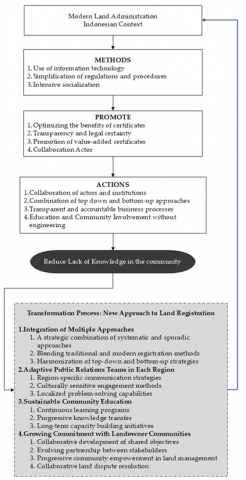
This article will look at the process of the stages of PTSL PM activities based on existing regulations. Furthermore, the researcher will also analyze the factors that affect the success of PTSL PM in meeting the target of the targeted land plot map by looking at internal factors and external factors. Internal factors are studied based on the performance of implementers consisting of the Land Office, as well as from survey and mapping companies using policy implementation theory. These internal factors will be analyzed by looking at aspects, such as human resources, facilities, bureaucratic structure, and implementation commitments, which all have an impact on the process and results of PTSL PM. External factors can be seen from the motivation and characteristics of the community. The motivation for the involvement of Puldatan members will be studied more deeply as a pillar in driving community participation. Meanwhile, the characteristics of the community are seen from education, gender, place of residence, social status, and social capital contained in the community. The results of the analysis are used to recommend a more effective implementation of PTSL PM. The conceptual framework of the research can be seen in Figure 1.
The purpose of the above scheme is to find out the obstacles and problems in the implementation of the program in which problems occur. Observation, carried out with non-partisan techniques, the determination of the location of the village is carried out by the Regional Office and the Regional Office, so that the selection and training process of Puldatan is monitored by the Physical Task Force and the Juridical Task Force [42]. The difficulty in the technique is that the researcher has to do two of the same work at the same time, namely participation and observation. In addition, on the other hand, the author must also maintain a distance from his research subject (even though he is participating) to keep his research objective. By doing this technique, researchers can feel and experience the work of Puldatan, the task force in implementing the PTSL PM program, to get an overview of the process of activities in the field. The interview was chosen because with this technique the author can ask questions directly to the informant (internal BPN) to find out the initial condition of the implementation of PTSL PM, internal support from the Land Office, community support, strategies and tips in the field where between expectations and reality are slightly different from the PTSL PM program. Informal interviews are adapted to the situation of the research subject, besides that it can also make informants more comfortable, honest, and open in providing information. Researchers will use the question guide at the time of conducting the interview, but the researcher can also develop the guide to get broader and deeper information. Interviews will be conducted with parties involved in the PTSL PM program, such as the Land Office, survey and mapping companies, physical and juridical task forces, surveyors, Puldatan, village officials, community representatives who participate in the PTSL PM program.
Figure 1. Conceptual framework of the research
This investigation examined the selection criteria employed by the Muaro Jambi District Land Office in designating Muaro Sebapo Village for the program, with particular attention to compliance with existing regulatory frameworks. The research methodology encompassed a comprehensive assessment of the committee selection process, coordination mechanisms between the land office administrative team and village authorities, and the community's preparedness for training programs focused on physical and legal land data collection. Utilizing a qualitative approach, the research team conducted in-depth interviews with a strategically diverse sample of stakeholders, comprising four land office administrative personnel, three external quality control consultants, and seven village representatives including designated physical and legal data collectors. This methodologically balanced sampling strategy facilitated the acquisition of data from both external and internal perspectives, thereby enabling triangulation of findings and enhancing analytical validity. The research specifically aimed to identify and analyze. Implementation barriers affecting prescribed targets and to formulate evidence-based recommendations for addressing these systemic challenges within the land registration framework.
3.1 The process of determining the PTSL PM of Muaro Jambi
The implementation of Complete Systematic Land Registration Based on Community Participation at the Muaro Jambi Office in the 2021 fiscal year is considered to require the participation of the community as a land data collector. Referring to the Decree of the Head of the Land Office of Muaro Jambi Regency in 2021 Number 37/SK-15.05. HP. 01/I/2021 dated January 4, 2021 concerning the Determination of Targets and Locations of Land Rights Certificates (SHAT) Complete Systematic Land Registration Activities (PTSL) Community Participation is described in Table 4.
Referring to the 2021 PTSL module. Cluster 1 (K1) is a land plot whose physical and legal data meets the requirements for issuing a land title certificate. Cluster 2 (K2) is a land plot whose physical and legal data meets the requirements for issuing a land title certificate but there is a case in court and/or dispute. Cluster 3 (K3) includes Cluster 3.1 the subject is unwilling to make a statement of BPHTB and/or PPh debt, and the PTSL location (object) is in the Indicative Map area for Termination of New Permit Issuance (PIPPIB). Cluster 3.3 is a PTSL product that is implemented up to the physical data collection stage because: there is no SHAT budget in the current budget year; the person concerned is willing to show the boundaries of his land, but is not yet willing to have the certificate issued Cluster 3.2, is a PTSL product that has been completed up to the stage of collecting physical data and collecting legal data Cluster 4 (K4) is a land area whose objects and subjects have been registered and have land rights certificates, which have not been mapped.
Table 4. Location of PTSL PM Muaro Jambi
|
No |
District |
Village |
Target PBT |
|||
|
BEFORE |
BECOME |
|||||
|
K4 |
K3 |
K4 |
K3 |
|||
|
1. |
Mestong |
Muaro Sebapo |
12 |
1000 |
12 |
1000 |
|
|
|
Palempang |
- |
1000 |
- |
1000 |
|
|
|
Tanjung Pauh KM 32 |
179 |
1000 |
216 |
1000 |
|
|
|
Tanjung Pauh KM 39 |
263 |
1000 |
298 |
1000 |
|
|
|
Tanjung Pauh Pelita |
- |
1000 |
- |
1000 |
|
|
|
Baru |
16 |
2000 |
16 |
2000 |
|
|
|
Nyogan |
635 |
1000 |
724 |
1000 |
Source: data processing, 2021
Sebapo Village was established in 2008. It is in the eastern crossing area of Sumatra (±60 km from Muaro Jambi). The main commodities are rubber and oil palm plantations where most residents in this village work in the plantations. The people of Muaro Sebapo Village generally have an average garden area of 1-3 ha with rubber and palm oil said Sudiran, one of the villagers In Muaro Sebapo. In general, most people migrate outside the area or do not inhabit the location, so often communication during data collection by the community experiences obstacles said the Head of RT in Muaro Sebapo. This fact makes the simplification of the registration process understandable [43, 44], and the community must have sufficient knowledge and collaboration [33, 45] of actors to make it easier to simplify the process.
The determination of the location of the field of land is determined by BPN to be completely handed over to the village, the process of counselling, socialization, and training is carried out not in each village but in one village attended by prospective village recipients of the program, the more villages are chosen, the socialization process is not easy and provides an understanding and understanding of the functions of the physical and juridical Task Force carried out by Puldatan absolutely helps the success of this program. Based on data from the minutes and interviews in the field, the community and Puldatan on average still do not master what their duties and functions are and expect BPN to be more proactive in providing training and disseminating information on this program. According to them the time was too short and there were still perceptions and understandings that were not in line with the candidates for physical and legal land data collection officers.
The sudden formation of Puldatan resulted in them being less ready to help the measurement team both in helping the designation of field boundaries and in collecting data on field owners. In the area around the city, because most of them are in urban areas, there are many companions (Puldatan team) who cannot accompany the survey team because they are still working in the office. In some villages for garden or swamp areas, companions have difficulty finding boundaries/markers that have long been lost, so many fields are missing. Another obstacle is that the short training and socialization process makes it difficult for community participation to want to participate.
The output of PTSL PM purely PBT from the beginning has been very insufficient to support the success of this strategic program considering that the community's expectations are certificates, but due to incomplete physical and juridical data, it will be even more difficult. Land data collectors (Puldatan) are community groups that are given training and assigned to be facilitators as well as implementers of the process of collecting physical and juridical data. Specifically, it can be described referring to the Decree of the head of the office, the Puldatan team is dominated by village officials and factually the head of the RT who works in the field is the head of the RT, this condition more or less leads to the condition that if there are technical obstacles related to physical and juridical aspects, then the KJSKB, the task force team, and the QC team need extra manpower to regulate the details and rhythm of the work. On the other hand, Output The work carried out by Puldatan is considered not optimal because they should be trained and given the ability to input and verify files, but this task is not optimal. Another consequence caused by this condition is that Puldatan does not have a workload because the workload has shifted to RTs whose residents participate in the PTSL PM program. On the other hand, the pattern of disbursement of financial administration that is collected behind after activities and data is collected complained by most RTs, they want the disbursement to be carried out after the files are collected and verified by RTs.
Figure 2 illustrates the core of land registration activities supported by third parties and Puldatan (Land Data Collection). This World Bank-funded program requires communities to understand the essential aspects of physical and juridical data completeness, which creates land parcel maps that strengthen the land database and benefit the community. This essence should ideally be reinforced through Puldatan from community participation. Unfortunately, the knowledge and experience transfer from Muaro Sebapo Village provides lessons that the transmission of data accuracy information will bring benefits to data quality and legal certainty for landowners needs to be campaigned more intensively to reduce knowledge gaps in village communities. Traditionally, they are familiar with land transactions that are not yet fully aligned with what is expected. The village election tends to be authoritative because the defense office wants all areas to be registered, but is not yet fully prepared to collaborate with the village of Muaro Sebapo in a more intensive and longer communication that is truly understood by prospective Puldatan members, because the socialization is very tight.
Figure 2. Validation of land plots carried out by Puldatan
3.2 Verification and validation of PTSL PM land area maps require time to ensure quality data
Many developing countries have obsolete, inaccurate, and untrustworthy land records [46], making it difficult to govern [47] and manage land resources effectively [48]. This World Bank-supported activity aims to simplify and complete physical data with technological and legal data, based on Puldatan, with the different nature of society and range of data items posing a problem in and of itself. A complete map of PTSL results that is useful for improving physical data information must include geographical elements found around land plots (such as roads, alleys, lakes, rivers, forest areas, ditches, ditches, ditches), public facilities, social facilities, which are depicted in the form of polygons in PBT and Geo KKP. Physical data collection activities can be carried out by delineating from a work map that has accuracy in accordance with the PTSL technical instructions, to be given a temporary identification number (NIS). The delineation of the boundaries of geographical elements intersects with the boundaries of land parcels that are directly adjacent to or with other geographical elements. Land plots whose owners are not yet known (no name)/no one who can determine the boundaries of land plots in the field or subjects are not willing to participate in PTSL activities, are delineated or can be formed from the results of the size of land plots that are directly bordered, given a Temporary Identification Number (NIS). If there is a plot of land that has been marked with a boundary mark, but the owner or his proxy, and/or the bordering neighbour is not present, then a temporary boundary is determined, and a temporary boundary is drawn in the form of a dotted line. The land plot map resulting from PTSL does not have an expiration date, but if there is a change in location, boundaries and area, it must be re-measured based on the recommendations of the soil inspection team. Objections from the bordering party, applications from landowners; and the settlement of possession and ownership disputes.
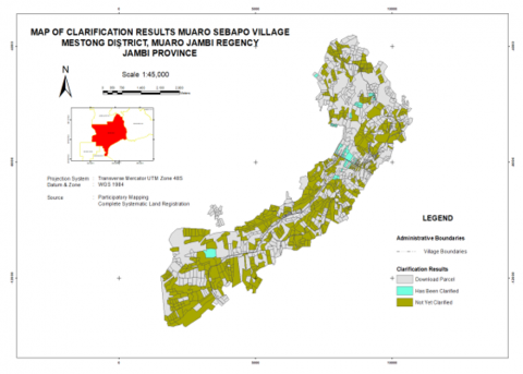
In Figure 3, the spatial distribution of completely verified physical and legal data fields—demarcated in Tosca green coloration—exhibits notably limited prevalence. This paucity primarily stems from the significant geographical dispersion of Muaro Sebapo landowners, many of whom maintain permanent residence outside the jurisdictional boundaries where their parcels are situated. This residential distribution pattern substantially impedes the data collection process by inhibiting direct communication with property owners within the prescribed temporal constraints of the verification protocol. The abbreviated timeframe allocated for data acquisition, when coupled with the spatial disconnect between landowners and their properties, creates a procedural impediment that adversely affects all stakeholders within the land registration ecosystem.
The issuance of PBT is carried out by paying attention to the printing of PBT from the KKP Application after being integrated with its juridical data, with a display of all land parcels in one overlay, both registered land parcels (K4) and unregistered fields. Referring to the technical guidelines, the results of the land plot maps produced often encounter obstacles in terms of slow progress of achievement because the KJSKB is faced with the reality in the field that the landowner does not want to pioneer the land plot that is not cared for by the boundary mark and the physical condition of the land for this reason. The next problem is the uncertain boundaries of the area and village administration in the village so that it is necessary to have discussions in the field regarding the administration, often the Land Office avoids locations like this.
Figure 3. Mapping process with community participation facilitates quality control
"The most difficult is the landowners who are not domiciled in the field."
This classic problem is because the community does not understand the boundaries and corridors of measurement because most people are only based on estimates at the time of measurement, sometimes not accompanied by the owner, only RT and several neighbours so that if there is a difference, there is a potential for technical problems in the field. The main key to the implementation of PTSL PM starts from the third-party recruitment process. The optimal performance of KJSKB, the Puldatan Team, and BPN internals is very necessary, especially when in the field to produce quality land map products.
In the PTSL PM program, community participation begins at the counselling and physical and juridical data collection stages. Counselling was carried out by the Land Office along with the PTSL PM Adjudication Committee (Physical Task Force and Juridical Task Force). During the counselling, they were informed about PTSL PM activities, stages and schedules of PTSL PM activities, Puldatan recruitment, Puldatan's rights and obligations, and financing of PTSL PM activities. In this activity, information related to the form of community participation and documents that must be collected by the community is also provided. Forms of community participation include installing boundary signs, being present in identification activities, and delineating land parcel boundaries, confirming registered land parcels, being present at the determination of land parcel boundaries, and signing survey drawings. After counselling, the formation of Puldatan and Puldatan training were carried out by the physical task force and the juridical task force. The material provided in this training is how to collect physical data, juridically, and how to mediate in the event of a dispute over the boundary/ownership of land plots. Participation in the PTSL PM program, especially by looking at the work of Puldatan, one of which will be focused on the counseling and physical and juridical data collection stages. The process of delivering knowledge and important information from the land office to the Puldatan is expected to be sustainable. With a dynamic approach, the existence of intensive training and education to the Puldatan will facilitate the process of disseminating the importance of this program and it is hoped that the wider community will utilize it optimally. This process must be realized by government agencies that this phase takes time.
3.3 Information transfer, community participation and collaboration in land registration
There is a wide gap in knowledge and mis information [49] in the land registration process [50]. Community participation in PTSL PM is one of the keys to the success of the program. One of the successes of the program is marked by high public interest in participating in the program [51, 52]. Public interest in the program is one of Kantah's considerations in choosing the location of the PTSL PM program. Based on the results of researcher interviews in several land offices, usually the land office communicates first to the village apparatus (village head) related to the implementation of the PTSL PM program. After that, the village officials discussed with community leaders, the head of RT/RW. If the village officials and community leaders are willing, the land office will conduct socialization. However, if the community is not willing, then the government will not run the program in the village.
The reason why the community rejected the PTSL PM program was because the community felt traumatized because they had previously paid for the creation of certificates, but it turned out that the certificates did not come out. The public always thinks that if measurements are taken, a certificate will be issued, but it turns out that it takes a long time or even the certificate does not come out. The community that is the location of the PTSL PM program no longer has confidence in BPN because in the previous program, Prona, the community did not get a certificate. Public acceptance of the program is very important in determining the running and success of a program.
One of the community's decisions to participate in the PTSL PM program is influenced by socialization. Socialization of PTSL PM is carried out by BPN, usually together with a third party who conducts measurements. Socialization is usually carried out once or twice at the village hall and invites village officials and community leaders. During the socialization, the BPN explained related to PTSL PM, introduced a third party, explanations related to Puldatan and appeals for villages to form Puldatan, and appeals related to the installation of stakes as markers for land parcel boundaries. After completing the socialization, usually the Head of Village Head and the heads of RW/RT disseminate information to the community related to the PTSL PM program. Information dissemination can be carried out through channels that are considered effective by village officials. Based on an interview with one of the people who participated in the PTSL PM program, stated:
"I found out about the PTSL PM program through the announcement of Mr. RW/RT, besides that there was information also at the mosque and from Whatsapp group information."
This implies that information related to the PTSL PM program received by the community depends on village officials who receive socialization from BPN. In addition, the community's decision to participate in the program or not also depends on how the message related to the program is packaged, the message channel used to convey the message, and who delivers the message. The packaging of the message will affect the community's interpretation of the program [53]. Messaging channels can be formal as well as informal, but usually informal channels and messages that are repeatedly delivered are more effective. The person who conveys the message is also very important, because often the person conveying the message is more important than the message itself.
The community has the idea that if there is a program from BPN, the program must be a certificate making program. In addition, there is an assumption in society that making certificates tends to be expensive, long, and convoluted.
"To take care of the certificate, if the usual route without a program is expensive, the cost can reach eight to ten million. In addition, the process is also long and convoluted. With this program, the community is very helped."
Therefore, in the PTSL PM program, the message emphasized is that this program is free and not convoluted, even BPN itself picks up the ball by registering directly for land plots. But in this program, the final output is a field map not a certificate, while the community still interprets the output of this program a lot, namely certificates. Certificates are the main goal of the community to participate in this program. For the community, the certificate is the highest proof of ownership. If you follow the program but do not get a certificate, for the community it is useless. The message channel used at the time of initial socialization by BPN is usually a formal channel. BPN coordinates with the village head or village head to conduct socialization, and the village head/village head gathers village officials and several community leaders to participate in the socialization. After the socialization carried out by BPN, usually village officials disseminate information through informal channels.
In line with the formal channel chosen during the socialization of PTSL PM by visiting the head of the village/village head. The head of the village or village head is chosen because they are an extension of the government at the village or sub-district level. This implies that the head of the village head as a representative of the government is always considered to be people who have power and influence in the community so that their appeal is heard and can influence the community in their participation in the PTSL PM program. However, this is not entirely true, often in society, informal leaders are more influential and powerful in society. In addition to religious leaders, if in a traditional village it is still very thick, usually traditional leaders still have a considerable influence. In this case, BPN must pay more attention to stakeholders in the community, their influence, and their role in society so that they can accurately determine effective socialization. To be able to find stakeholders, one way can be stakeholder analysis or stakeholder mapping. Message packaging, message channels, and the party delivering the message are factors that must be considered in communication, especially socialization to the community. In addition, public access to information is important. People in cities and districts, of course, people's access to information is different.
Effective collaboration between land office leaders and government [50], then local informal and formal leaders [54] should be involved to design a suitable scheme not only internal formal regulations but also agreement between parties is very important for the success of land registration on site [55]. This involves good governance, involvement of local experts [8], strong political commitment [3], and innovative public-private partnerships [56]. Overcoming institutional barriers and governance issues is very important for the sustainability [57] and effectiveness of the land registration system [58]. From this process, a mechanism can be established that is agreed upon by all parties and is easy to do without ignoring formal legal requirements.
As a state institution with program interests, Complete Systematic Land Registration implements standard operating procedures (SOPs) consisting of 5 stages. Stage 1 involves preparation and planning of work, stage 2 covers location assignment, stage 3 focuses on preparation for the formation of the Puldatan/adjudication committee, stage 4 includes Puldatan counseling and training, and stage 5 encompasses the collection of physical and juridical data from Puldatan. Stage 3 constitutes one of the most critical stages; nevertheless, this stage demonstrates suboptimal performance. This stage serves as the fundamental foundation for information transfer and community participation. The Standard Operating Procedures implement decree and poster notification. While these technical approaches are commendable, they are less suitable within the context of rural communities with limited literacy. Oral socialization delivered by village officials proves more effective during this phase. At this stage, the person in charge of activities are extremely important. Field conditions indicate that local stakeholder involvement is crucial; however, intensive communication between program managers and village officials remains essential. Village officials, as key local stakeholders responsible for implementation—such as village secretaries, bayans (village messengers), and neighborhood/community unit leaders (RT/RW)—still function relatively optimally. The substandard performance in this phase stems not only from insufficient knowledge and information among the general public but also from inadequate formal legal knowledge regarding land registration processes among local village officials. Regarding local offices, the PTSL team could effectively utilize local offices and institutions as home bases, and this has already been implemented in a structured manner. The component of selecting and appointing Puldatan members and announcing this to the relevant villages has been performed adequately, as this does not present significant difficulties provided local village officials are willing to cooperate.
Furthermore, the social control mechanism involving comprehensive community and local government participation in Puldatan establishes a collaborative approach to land registration. This mechanism constitutes an integrated component of the SOP structure that is intertwined within reciprocal information transfer processes. The interrelationship of each subsystem within Puldatan serves to strengthen socialization and information transfer for communal awareness. The awareness of communality through community participation cannot be disregarded, as information transfer and validation necessitate public oversight to ensure proper implementation of SOPs. The structural dependency of society through public participation in Puldatan is considered the optimal approach for local land certification. The aggregation of systematized information in the transfer of land certification registration information absolutely requires public participation intervention. The objective of public participation in information transfer is to affirm community control over land boundary validations. Land boundary validation derived from community information can function as part of a check and balance mechanism at the village level. Information transfer from the community regarding land boundary validation represents a recognition of local knowledge. Local knowledge concerning land history for certification becomes the informational foundation for strengthening the legality of unrecorded land. The reciprocal information from village officials actively involved as persons in charge demonstrates community participation and concern in land data collection. It must also be emphasized that the social control mechanism in participation and collaboration for land registration at the local level serves to reduce the manipulation of land-related information. Manipulation of information regarding land history can lead to fragmented information; therefore, community participation constitutes a form of social control in the land registration information transfer process.
Stage 3, preparation for the formation of the Puldatan, constitutes a critical phase that determines the success or failure of a program. Field findings indicate that the resolution of disputes related to tensions in land data collection claims can be mediated through public control. Typically, failures in land registration occur due to objections from parties who believe they possess legal certification of land ownership but do not receive public validation legitimacy. This situation usually results from conflicts of interest caused by information manipulation and duplicate certificates for the same land. Information manipulation and duplicate certificates commonly represent routine falsification within the regulatory domain, resulting from the failure to consider public input regarding land information. Additionally, the paucity of historical land records further reinforces misinformation about land ownership. Therefore, strengthening the Puldatan formation at the local level as a dispute resolution mechanism can minimize fragmented information regarding duplicate claims to land certificates. Consequently, Stage 3 necessitates adequate time allocation, educational initiatives, and consistent, sustainable implementation to achieve its objectives. This phase is crucial where the systematic complete land registration project that occurs should be passed through two top down approaches, programs from the government and public interest in registering their land. This condition will be successful if training through Puldatan is carried out continuously and not in a hurry and there is a public communication strategy from within the land office. Transformation begins by placing the interests of registering precise community land not only as government achievements but also community support with a humanist approach.
3.4 Implementation success hinges on active community engagement backed by structured educational processes
The absence of effective implementation will prevent policymakers' decisions from being successfully executed [59]. Policy implementation constitutes the operational phase that follows the formal authorization of policy directives. It involves the strategic management of resources to generate desired societal outcomes. This implementation phase fundamentally differs from policy formulation in its approach and methodology. While policy formulation adheres to a bottom-up paradigm, originating from community needs, aspirations, and advocacy, policy implementation follows a top-down hierarchical structure, transforming conceptual policy frameworks into concrete, implementable actions at the ground level [60].
In terms of implementation, there are two effective models of public policy implementation, namely the linear model and the interactive model [61]. The linear approach prioritizes the decision-making component while diminishing the significance of implementation, often relegating it to other stakeholders. Implementation success is intrinsically linked to the implementing agencies’ operational effectiveness. Implementation failures are predominantly attributed to perceived managerial deficiencies in commitment, highlighting the imperative for robust institutional capacity-building initiatives among implementing organizations. The interactive model requires the commitment of all stakeholders, characterized by an understanding of the basic principles of land registration, namely physical and juridical aspects to ensure land rights and reduce conflict.
Based on Figure 4, an analytical comparison between the interactive implementation model and other frameworks, specifically Grindle’s political-administrative process model, reveals significant conceptual overlap and shared characteristic elements. Grindle’s emphasis on policy objectives, action programs, and funded projects mirrors the linear model’s focus on decision-making primacy (Figure 5). The six content elements and three contextual factors in Grindle’s framework exemplify the complex interactions among policy architects, implementers, and recipients central to the interactive model. The implementation process is the essential mechanism linking policy intentions to their actualization through governmental initiatives, aligning with Van Meter and Horn’s theoretical framework [62]. The task of implementation is to build a network that allows public policy objectives to be realized through the activities of government agencies involving various interested parties (policy stakeholders).
Figure 4. Transformation new approach land registration analysis
Figure 5. Linear model of policy implementation analysis
The success of the PTSL program’s community participation component hinges on lucid communication among implementing actors. This communication framework encompasses three critical dimensions: information transmission mechanisms, message clarity, and consistent information delivery. Resource allocation encompasses four vital components: sufficient human capital in quantity and expertise, robust decision-making information systems, adequate authoritative power for duty execution, and essential implementation infrastructure. The implementers’ attitude, particularly their program commitment, plays a crucial role. Bureaucratic architecture is founded upon standardized operational guidelines that regulate workflow patterns and policy implementation mechanisms. Local level strategy of land office and approach pattern that requires sensitivity from land office to understand the character of muaro sebappo village residents to be patient not to rush to organize socialization and free time while intensive Puldatan education is possible to succeed. better time land registration is open all year round. Transparency of information management is highly dependent on the quality of data in the community. from this process will open interactive dialogue so that the chance of success percentage increases where the interest of this success is not for land office but for public interest, namely every inch of land is registered, mapped precisely and supported by good data accuracy so as to reduce disputes in the future.
The implementation of Land Registration Revitalization in Indonesia continues as one of the efforts to improve societal welfare and remains a national development priority. This program offers various benefits to communities, including legal certainty and long-term socioeconomic security. Despite these noble objectives, the implementation process faces numerous obstacles, with the most crucial factor being low indicators of public knowledge and participation. Research conducted in Muaro Sebapo demonstrates the problematic conditions of land registration in Indonesia, where administrative inefficiencies and inadequate legal documentation frequently trigger disputes and impede economic progress. Issues concerning inefficiency, accuracy, and public trust through the integration of local communities in registration protocols have persisted from the first era of land certification until the present day. This indicates that reducing knowledge gaps regarding land registration programs that prioritize community participation can substantially decrease registration duration and related expenditures while simultaneously enhancing data reliability through community involvement. Evidence shows that many landowners in Muaro Sebapo who reside outside their land's location (absentee landowners) face particular challenges in the registration process. Adaptive policy measures that incorporate the cultural and social dynamics of indigenous communities, advocate for targeted and sustainable training programs, and capacity development initiatives would facilitate community engagement with information technology tools. Dynamic and dialogical policies are essential for the success of this program, particularly in implementation processes that directly interact with rural communities possessing limited knowledge. This study carries significant implications by highlighting the transformative potential of community-driven approaches in revolutionizing land registration systems, emphasizing active participation and knowledge dissemination to establish legal certainty and promote sustainable economic development in developing countries. Moving forward, the integration of "Puldatan" as a transformative mechanism for active community participation, coupled with comprehensive educational initiatives and substantive support from sustainable land management offices, can effectively minimize existing socioeconomic disparities. This multi-faceted approach facilitates equitable resource distribution while addressing structural inequalities through systematic institutional frameworks. Educational processes and information knowledge transfer must be continuously distributed through the establishment of land data collection groups (Puldatan), enabling landowners residing far from their property locations to gradually develop greater attention to the status of their land ownership. In the future, further research is needed on how the Puldatan performance and the best learning strategies in Indonesia are.
We extend our sincere gratitude to all collaborators and stakeholders who contributed to strengthening this research's methodological rigor and analytical depth. We particularly acknowledge the Indonesia Ministry of Agrarian Affairs and Spatial Planning for providing the institutional support and research autonomy that enabled the thorough investigation of this significant topic. The author would like to acknowledge the Research Centre for Social Welfare, Villages, and Connectivity for supporting this study. The authors hope this study will positively contribute to society and academia regarding public policy in land certification policy.
This research was funded by the Ministry of Agrarian Affairs and Spatial Planning/National Land Agency, grant number 236/SK-100.03.LB.03/II/2021, and the APC was funded by the entire Research Team and not by research funders.
Arditya Wicaksono, Nanang Haryono, Eko Wahyono: conceptualisation, investigation, data curation, software, and writing- original draft. Yumantoko, Bahar Trianindha Putri, Rossany Maulida Diandra, Gustaf Wijaya: resources, supervision, writing–review and editing, and validation. Trie Sakti. Eliana Sidipurwanti, Herma Juniati, Sahajuddin: formal analysis, data presentation, and software. Arditya Wicaksono, Reza Amarta Prayoga: formal analysis, methodology.
Ethics approval was obtained from the Indonesia Ministry of Agrarian Affairs and Spatial Planning Ethics Committee: Letter 4/SK-100.7.LB.03/IV/2024.
[1] Morales, J., Lemmen, C., de By, R.A., Dávila, A.E.O., Molendijk, M. (2021). Designing all-inclusive land administration systems: A case study from Colombia. Land Use Policy, 109: 105617. https://doi.org/10.1016/j.landusepol.2021.105617
[2] Sok, S., Yu, X. (2021). Co-management of small-scale fishery in the Tonle Sap Lake, Cambodia. Regional Sustainability, 2(1): 1-11. https://doi.org/10.1016/j.regsus.2020.12.002
[3] Byamugisha, F.F. (2021). Experiences and development impacts of securing land rights at scale in developing countries: Case studies of China and Vietnam. Land, 10(2): 176. https://doi.org/10.3390/land10020176
[4] Gedefaw, A.A., Atzberger, C., Seher, W., Agegnehu, S. K., Mansberger, R. (2020). Effects of land certification for rural farm households in Ethiopia: Evidence from Gozamin District, Ethiopia. Land, 9(11): 421. https://doi.org/10.3390/land9110421
[5] Deininger, K., Feder, G. (2009). Land registration, governance, and development: Evidence and implications for policy. The World Bank Research Observer, 24(2): 233-266. https://doi.org/10.1093/wbro/lkp007
[6] Flores, C.C., Tan, E., Buntinx, I., Crompvoets, J., Stöcker, C., Zevenbergen, J. (2020). Governance assessment of the UAVs implementation in Rwanda under the fit-for-purpose land administration approach. Land Use Policy, 99: 104725. https://doi.org/10.1016/j.landusepol.2020.104725
[7] Chigbu, U.E., Bendzko, T., Mabakeng, M.R., Kuusaana, E.D., Tutu, D.O. (2021). Fit-for-purpose land administration from theory to practice: Three demonstrative case studies of local land administration initiatives in Africa. Land, 10(5): 476. https://doi.org/10.3390/land10050476
[8] Waeterloos, E. (2021). Introducing collaborative governance in decentralized land administration and management in South Africa: District land reform committees viewed through a ‘system of innovation’ lens. Land, 10(5): 534. https://doi.org/10.3390/land10050534
[9] Enemark, S., McLaren, R., Lemmen, C. (2021). Fit-for-purpose land administration—providing secure land rights at scale. Land, 10(9): 972. https://doi.org/10.3390/land10090972
[10] Suhattanto, M.A., Wijayanti, T.I. (2023). Implementation of community-based surveying and mapping of land parcels through field work practice to support complete systematic land registration (PTSL). IOP Conference Series: Earth and Environmental Science, 1276(1): 012004. https://doi.org/10.1088/1755-1315/1276/1/012004
[11] Balas, M., Carrilho, J., Lemmen, C. (2021). The fit for purpose land administration approach-connecting people, processes and technology in Mozambique. Land, 10(8): 818. https://doi.org/10.3390/land10080818
[12] Biraro, M., Zevenbergen, J., Alemie, B.K. (2021). Good practices in updating land information systems that used unconventional approaches in systematic land registration. Land, 10(4): 437. https://doi.org/10.3390/land10040437
[13] Indrajit, A.G.U.N.G., Jaya, V.E., Van Loenen, B., Lemmen, C.H.J., Van Oosterom, P.J.M., Ploeger, H.E.N.D.R.I.K., Theodore, R. (2020). The role of land administration domain model and spatial data infrastructure in improving ease of doing business in Indonesia. In (Cancelled) Annual World Bank Conference on Land and Poverty 2020: Institutions for Equity&Resilience.
[14] Enemark, S., McLaren, R., Lemmen, C. (2015). Fit-for-Purpose Land Administration Guiding Principles. Global Land Tool Network (GLTN): Copenhagen, Denmark.
[15] Marryanti, S., Purbawa, Y. (2018). Optimization of factors that influence the success of Complete Systematic Land Registration. BHUMI: Jurnal Agraria dan Pertanahan, 4(2): 190-207. https://doi.org/10.31292/jb.v4i2.278
[16] Chatterjee, P., Datta, S.K. (2024). Preserving environmental quality of ecotourism sites through community participation in Purulia District of West Bengal, India. Regional Sustainability, 5(3): 100163. https://doi.org/10.1016/j.regsus.2024.100163
[17] Bennett, R.M., Unger, E.M., Lemmen, C., Dijkstra, P. (2021). Land administration maintenance: A review of the persistent problem and emerging fit-for-purpose solutions. Land, 10(5): 509. https://doi.org/10.3390/land10050509
[18] Abubakari, Z., Richter, C., Zevenbergen, J. (2018). Exploring the “implementation gap” in land registration: How it happens that Ghana’s official registry contains mainly leaseholds. Land Use Policy, 78: 539-554. https://doi.org/10.1016/j.landusepol.2018.07.011
[19] Domeher, D., Abdulai, R. (2012). Land registration, credit and agricultural investment in Africa. Agricultural Finance Review, 72(1): 87-103. https://doi.org/10.1108/00021461211222141
[20] Biitir, S.B., Kuusaana, E.D. (2020). Customary land rents administration in Ghana: Emerging discourse on family lands in the Upper West Region. Survey Review, 52: 372. https://doi.org/10.1080/00396265.2019.1610609
[21] Ekemode, B.G., Adegoke, O.J., Aderibigbe, A. (2017). Factors influencing land title registration practice in Osun State, Nigeria. International Journal of Law in the Built Environment, 9(3): 240-255. https://doi.org/10.1108/IJLBE-04-2017-0014
[22] Yami, M., Snyder, K.A. (2016). After all, land belongs to the state: Examining the benefits of land registration for smallholders in Ethiopia. Land Degradation & Development, 27(3): 465-478. https://doi.org/10.1002/ldr.2371
[23] Narh, P., Lambini, C.K., Sabbi, M., Pham, V.D., Nguyen, T.T. (2016). Land sector reforms in Ghana, Kenya and Vietnam: A comparative analysis of their effectiveness. Land, 5(2): 8. https://doi.org/10.3390/land5020008
[24] Lemmen, C., Van Oosterom, P., Bennett, R. (2015). The land administration domain model. Land Use Policy, 49: 535-545. https://doi.org/10.1016/j.landusepol.2015.01.014
[25] Mallory, G., Crandall, M.S., Hajjar, R., Leahy, J. (2024). An analysis of political identity development in state forest advisory groups. Journal of Forestry, 122(5-6): 450-458. https://doi.org/10.1093/jofore/fvae014
[26] Navratil, G. (2020). Applications of GIScience for Land Administration. ISPRS International Journal of Geo-Information, 9(7): 416. https://doi.org/10.3390/ijgi9070416
[27] Tan, E., Pattyn, V., Flores, C.C., Crompvoets, J. (2021). A capacity assessment framework for the fit-for-purpose land administration systems: The use of unmanned aerial vehicle (UAV) in Rwanda and Kenya. Land Use Policy, 102: 105244. https://doi.org/10.1016/j.landusepol.2020.105244
[28] Massey-Galvis, M.L., Parra-Valencia, J.A. (2023). Exploring the systemic causes of land inequality with systems thinking. In Managing Complex Tasks with Systems Thinking. Cham: Springer Nature Switzerland, pp. 281-303. https://doi.org/10.1007/978-3-031-40635-5_12
[29] Davidson, N.C., Middleton, B.A., McInnes, R.J., Everard, M., Irvine, K., Van Dam, A.A., Finlayson, C.M. (2018). Introduction to the Wetland Book 1: Wetland Structure and Function, Management, and Methods. https://doi.org/10.1007/978-90-481-9659-3_356
[30] Bennett, R.M., Hutabarat, I.R., Unger, E.M., Ginting, C. P., van der Vegt, H., Latif, A. (2023). Digital transformation in Indonesian land administration: Further developments and directions. In Geospatial Science for Smart Land Management. CRC Press, pp. 43-67. https://doi.org/10.1201/9781003349518-7
[31] Nega, W., Tenaw, M., Hunie, Y., Agegnehu, S.K., Mansberger, R. (2021). Evaluating institutional dichotomy between urban and rural land administration in Amhara region, Ethiopia. Sustainability, 13(16): 9431. https://doi.org/10.3390/su13169431
[32] Gunton, T., Rutherford, M., Dickinson, M. (2010). Stakeholder analysis in marine planning. Environments, 37(3): 95. https://www.researchgate.net/publication/228641686.
[33] Schmidt, L., Hartberger, K., Kobbe, S., Falk, T., Wesselow, M., Schumann, C. (2018). Stakeholder involvement in transdisciplinary research: Lessons from three projects on sustainable land management in a north-south setting. Gaia-Ecological Perspectives for Science and Society, 27(3): 312-320. https://doi.org/10.14512/gaia.27.3.12
[34] Hanstad, T. (1998). Designing land registration systems for developing countries. American University International Law Review, 13(3): 647-703.
[35] Huda, N., Hernandi, A., Gumilar, I., Meilano, I., Cahyaningtyas, L.A. (2024). The strategic development of quality improvement land data incrementally using integrated PESTEL and SWOT analysis in Indonesia. Land, 13(10): 1655. https://doi.org/10.3390/land13101655
[36] Martono, D.B., Aditya, T., Subaryono, S., Nugroho, P. (2021). The legal element of fixing the boundary for Indonesian complete cadastre. Land, 10(1): 49. https://doi.org/10.3390/land10010049
[37] Rahmi, E. (2019). Legal certainly of land registration towards sustainable national development. International Journal of Recent Technology and Engineering, 8(2S9): 240-244. https://doi.org/10.35940/IJRTE.B1053.0982S919
[38] Setiabudhi, D.O., Palilingan, T.N., Maramis, F., Yunus, A. (2019). Collective land certification policy for improving good land governance. In IOP Conference Series: Earth and Environmental Science, 343(1): 012068. https://doi.org/10.1088/1755-1315/343/1/012068
[39] Sumanto, L. (2020). The future on publication system of land registration in Indonesia. International Journal of Scientific & Technology Research, 9(3): 1399-1401.
[40] Wibowo, H.Y. (2019). Implementation of complete systematic land registration in order to modernize Indonesian land administration system. In FIG Working Week.
[41] Nurcahyo, D.J., Wahyono, E.B., Mujiburrohman, D.A. (2019). Community participation-based complete systematic land registration (ptsl+pm) in Ngawi district. Tunas Agraria, 2(3): 139-161. https://doi.org/10.31292/jta.v2i3.43
[42] Tedlock, B. (1991). From participant observation to the observation of participation: The emergence of narrative ethnography. Journal of Anthropological Research, 47(1): 69-94. https://doi.org/10.1086/JAR.47.1.3630581
[43] Abubakari, Z., Richter, C., Zevenbergen, J. (2020). Making space legible across three normative frames: The (non-) registration of inherited land in Ghana. Geoforum, 108: 217-226. https://doi.org/10.1016/j.geoforum.2019.11.002
[44] Mehta, N., Rani, R., Kalra, N. (2023). Blockchain based system for secure property registration. In 2023 International Conference on Sustainable Computing and Smart Systems (ICSCSS), pp. 1426-1433. https://doi.org/10.1109/ICSCSS57650.2023.10169812
[45] Ghojdya, M.T., Shirvanyb, A., Shamsic, R.F., Lexerd, M.J. (2009). Prioritizing stakeholders of integrated land use management in Arasbaran, Iran. Austrian Journal of Forest Science, 227. https://www.researchgate.net/publication/287846723.
[46] Moreri, K., Fairbairn, D., James, P. (2018). Issues in developing a fit for purpose system for incorporating VGI in land administration in Botswana. Land Use Policy, 77: 402-411. https://doi.org/10.1016/j.landusepol.2018.05.063
[47] Fayyad, M., Al-Sinnawi, A.R. (2023). Challenges of sporadic land registration in Palestine. Land Use Policy, 131: 106723. https://doi.org/10.1016/j.landusepol.2023.106723
[48] Moreri, K.K. (2020). Using Kappa methodology to consider volunteered geographic information in official land administration systems in developing countries. Spatial Information Research, 28(3): 299-311. https://doi.org/10.1007/s41324-019-00289-7
[49] Ayano, M.F. (2018). Rural land registration in Ethiopia: Myths and realities. Law & Society Review, 52(4): 1060-1097. https://doi.org/10.1111/lasr.12369
[50] Törhönen, M.P. (2004). Sustainable land tenure and land registration in developing countries, including a historical comparison with an industrialised country. Computers, Environment and Urban Systems, 28(5): 545-586. https://doi.org/10.1016/j.compenvurbsys.2003.11.007
[51] Mthembu, Z., Chimbari, M. (2023). Community engagement: Health research through informing, consultation, involving and empowerment in Ingwavuma community. Frontiers in Public Health, 11: 1050589. https://doi.org/10.3389/fpubh.2023.1050589
[52] Silumbwe, A., Halwindi, H., Zulu, J.M. (2019). How community engagement strategies shape participation in mass drug administration programmes for lymphatic filariasis: The case of Luangwa District, Zambia. PLoS Neglected Tropical Diseases, 13(11): e0007861. https://doi.org/10.1371/journal.pntd.0007861
[53] Wicaksono, A., Wahyono, E., Wijaya, G. (2024). Dynamic implementation of land registration acceleration through community participation: A case study in Banjar District, South Kalimantan Province. Journal of Infrastructure Policy and Development, 8(7): 5246. https://doi.org/10.24294/jipd.v8i7.5246
[54] Fahmi, F.Z., Prawira, M.I., Hudalah, D., Firman, T. (2016). Leadership and collaborative planning: The case of Surakarta, Indonesia. Planning Theory, 15(3): 294-315. https://doi.org/10.1177/1473095215584655
[55] Ibrahim, A.S., Akanbang, B.A.A., Laube, W. (2022). Sustaining decentralized collaborative governance arrangements in Africa: A case study of land management committees in the Upper West Region, Ghana. GeoJournal, 87(2): 641-660. https://doi.org/10.1007/s10708-020-10276-3
[56] García-Morán, A., Ulvund, S., Unger, E.M., Bennett, R.M. (2021). Exploring PPPs in support of fit-for-purpose land administration: A case study from Côte d’Ivoire. Land, 10(9): 892. https://doi.org/10.3390/land10090892
[57] Marwick, B. (2013). A collaborative framework to support a national land information infrastructure in Australia. University of Melbourne, Department of Infrastructure Engineering.
[58] Ho, S., Choudhury, P.R., Haran, N., Leshinsky, R. (2021). Decentralization as a Strategy to Scale Fit-for-Purpose Land Administration: An Indian perspective on institutional challenges. Land, 10(2): 199. https://doi.org/10.3390/land10020199
[59] Lengoiboni, M., Richter, C., Zevenbergen, J. (2019). Cross-cutting challenges to innovation in land tenure documentation. Land Use Policy, 85: 21-32. https://doi.org/10.1016/j.landusepol.2019.03.023
[60] Oliver, K., Innvar, S., Lorenc, T., Woodman, J., Thomas, J. (2014). A systematic review of barriers to and facilitators of the use of evidence by policymakers. BMC Health Services Research, 14: 2. https://doi.org/10.1186/1472-6963-14-2
[61] David, A. (2001). Models implementation: A state of the art. European Journal of Operational Research, 134(3): 459-480. https://doi.org/10.1016/S0377-2217(00)00269-1
[62] Grindle, M.S. (2017). Politics and Policy Implementation in the Third World.