Jonatan Ernesto Rivera-Garcia![]() | Bartolo Cruz-Romero*
| Bartolo Cruz-Romero*![]() | Julio Cesar Morales-Hernández
| Julio Cesar Morales-Hernández![]() | Oscar Frausto Martínez
| Oscar Frausto Martínez![]()
© 2025 The authors. This article is published by IIETA and is licensed under the CC BY 4.0 license (http://creativecommons.org/licenses/by/4.0/).
OPEN ACCESS
Landslides occur across diverse ecosystems, soil types, altitudes, and climatic conditions, making their occurrence dependent on multiple factors. This study analyzes the triggering conditions that led to a debris flow in San Gabriel, Mexico, in 2019, which caused damage to public and private infrastructure. A key focus is the role of land use change induced by fire as a complementary triggering factor. Satellite imagery was used to assess land use and land cover (LULC) changes before the event, immediately after, and two years later. Additionally, a landslide scenario was modeled for each LULC stage using complementary layers. The results indicate an increase in high landslide susceptibility when fire occurred, as observed in the damaged vegetation, which showed partial recovery after two years. This study highlights the influence of agricultural land demand and inadequate land management practices in supporting the expansion of the avocado industry, emphasizing the need for sustainable land-use planning to mitigate landslide risks.
land degradation, intensive agriculture, triggering factors, anthropogenic, landslide, infiltration loss, runoff increased
Landslide triggered by anthropogenic factors have increased significantly in recent years. The primary causes include deforestation, excavation, infrastructure constructions, vibrations from machinery, heavy vehicle transit and changes in infiltration rates due to urbanization [1-3].
Wildfires are a major environmental hazard that shapes landscape but also pose a risk to human lives, infrastructure and ecosystems. They influence vegetation distribution, soil quality and carbon cycles often intensifying due to natural disasters, climate conditions and human activities. Wildfires accelerate erosion and soil degradation, increasing the likelihood of landslides, with their intensity depending on the fire´s magnitude and duration [4, 5].
In México and worldwide, landslides have significant impacts on environmental, human and infrastructure wellbeing, particularly in Latin American cities where rapid population growth and social inequality force many families to settle at-risk area along urban fringes, where land is accessible but often unrecognize by local authorities, because of its risk condition. Thin informal settlements frequently lack basic services, face land tenure issues, and are located in high-risk zones, making their communities [6].
Landslides involve the downslope movement of materials that once formed stable slopes, depressions, or ravines. This occurs when soil loses its stability, leading to surface modifications driven by gravity. The movement is influenced by inherent factors such as geomorphology, geology and vegetation cover, as well as triggering factors like seismic activity, volcanic eruptions, heavy rainfalls, and human-induced modifications [1, 7].
In addition to this factors land use change, agricultural expansion, forest fragmentation, population density plays crucial roles in landslide susceptibility. Anthropogenic forest fires, in particular, contribute to significant landscapes alterations [8]. Therefore, this research aims to analyze the causes and triggering factors behind the landslide event that affected San Gabriel, Mexico.
1.1 Wildfires and agriculture: A long-standing relationship
Fire has been part of the Earth's history for hundreds of millions of years, occurring in all biomes, and playing a key role in ecosystem dynamics. It influences plant growth, regeneration, species composition and soil distribution [9, 10].
Traditionally, wildfires have been used as a land management tool, providing essential organic and mineral nutrients for crops. However, in recent decades, fire has been extensively used to convert land for agricultural purposes, driving widespread land use changes. An estimated 400 million hectares burn annually, with 90% of these fires caused by human activity, primarily for agriculture.
In Mexico, between 2010 and 2020, an average of 7,500 wildfires per year affected over 4.5 million hectares [11], while Jalisco state recorded the highest incidence of wildfires in the country [12].
In 2022 alone, Jalisco reported 1,448 wildfires, of which 63% (913 fires) were classified as forest fires, while the remaining 37% (535 fires) were non-forest fires related to agricultural activities. These fires collectively burned 66,245 hectares, averaging 72 hectares per fire. The most affected vegetation types were pine and oak forests, which accounted for 89% of the total burned area. Alarmingly, 75% of these fires were directly linked to agricultural expansion [13].
Intense wildfires disrupt geomorphological processes and alter soil hydrology, significantly affecting infiltration rates, moisture retention, and nutrient cycles. Fires reduce chlorophyll levels, weaken vegetation structure, and increase the amount of bare soil, exposing landscapes to erosion and degradation [5, 14].
These alterations increase surface runoff and reduce soil infiltration, heightening the risk of flash floods, debris flows, and landslides [15]. Extreme fire temperatures—sometimes reaching 60℃ in the soil—disrupt microbiological cycles, preventing soil from performing essential ecosystem functions [16].
If current land use and management trends persist, critical soil-environmental services will be at risk. To ensure sustainability, it is crucial to develop strategies to regulate fire use, control agricultural expansion, and implement land management programs, especially in fire-prone mountainous regions.
2.1 Study area
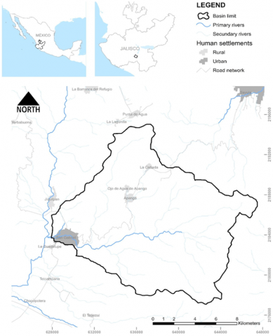
The study area is located in western Mexico, within the municipality of San Gabriel, in the south of the state of Jalisco; it shares borders the municipalities of Talpa and Sayula to the north, Tolimán and Zapotitlán de Vadillo to the south, Zapotlán el Grande and Gómez Farías to the east, and Tonaya and Tuxcacuesco to the west (refer to Figure 1). According to the national population census, San Gabriel has a population of 5,109 inhabitants, accounting for 30.9% of the total population of the district. The population distribution is 49% male and 51% female, with a growth rate of approximately 50 inhabitants per year [17].
Figure 1. Location of the study area
The municipality's topography is shaped by the Trans-Mexican Volcanic Belt, with altitudes ranging from 880 to 3,900 meters above sea level. The climate is predominantly semi-warm and semi-humid (60.4%), with temperate sub-humid conditions covering 32.1% of the territory. Annual temperatures range from 7.5℃ to 29.9℃, with an average of 18.9℃, while annual rainfall is approximately 860 mm, with an accumulated total of 622.48 mm [18].
The region's dominant lithology consists of igneous intermediate extrusive rock (37.6%), which originates from volcanic activity and experiences slow subsurface cooling. This is followed by tuff deposits (33.8%), composed of porous volcanic ash and small pyroclastic materials [19].
Regarding soil composition, the primary soil type is Regosol (33.2%), which has poor physical properties, low organic matter content, and variable fertility. Cambisol (31.5%) is the second most prevalent soil type, characterized by high clay and iron oxide content, rich organic matter, and high fertility, making it suitable for agriculture [20].
The municipality's land use is predominantly agricultural, covering 38.1% of the total area. The primary crops include corn, agave, avocado, chili, sorghum, tomato, onion, lemon, and beans [21].
Forests make up 33.6% of the land, with 23.2% consisting of primary vegetation that remains largely undisturbed, while 6.6% is secondary vegetation undergoing natural regeneration. The region supports diverse ecosystems, including coniferous and oak forests, mesophyll forests, pine-tascate forests, deciduous and sub-deciduous forests, gallery vegetation, and natural palm groves [18].
The upper basin of the Salsipuedes River was selected as the study area, covering 19,031 hectares. On June 2, 2019, a debris flow event occurred, triggered by extreme rainfall, which transported poorly consolidated material downhill, causing significant damage. One month earlier, on May 3, 2019, a forest fire broke out in the region. It burned for 13 days before being extinguished on May 16, affecting 12,000 hectares of pine-oak and low subdeciduous forest [12].
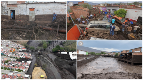
Figure 2 shows: A). The effects in a house façade, where the height reach by the debris can be seen, B). Effects on local roads due to the obstruction of the flow by local elements with high amount of tree trunks, C). Aerial view of the footprint left by the debris flow. And D). Section of the Salsipuedes River at its intersection with a local bridge in the urban area of the town of San Gabriel.
Figure 2. Location of the study area
The images reveal a dark layer of transported material and significant tree debris. However, according to local testimonies, no rainfall was recorded in San Gabriel on the day of the event. This raises several key questions: What were the natural causes of the debris flow? If there was no recorded rainfall in the town, what triggered the event? What conditions in the upper basin contributed to the disaster? What measures should be implemented to prevent similar future events?
2.2 Methods and procedures
The methodology applied in this study follows a structured approach to assess the factors influencing the debris flow event and to model landslide susceptibility in the San Gabriel region. The process is divided into three main components: LULC determination, change detection in LULC, and landslide modeling. Figure 3 summarizes the workflow, illustrating the inputs, processes, and interactions among the different methodological stages.
Figure 3. Flow diagram of the methods and procedures
The first stage focuses on the classification of LULC using satellite imagery within a GIS environment, enabling the identification of key landscape features before and after the event. The second stage applies a change detection analysis to quantify land cover transformations over time, providing insight into the role of wildfires and human activities in altering landscape stability. Finally, the landslide modeling phase integrates multiple environmental factors into a susceptibility assessment, allowing for the spatial identification of areas prone to future instability.
This methodology provides a replicable and scalable framework for environmental monitoring, leveraging open-access satellite data and GIS tools to ensure broad applicability. The detailed description of each methodological step is provided in the following sections.
2.2.1 LULC determination
LULC classification was determined using Sentinel-2 imagery from the European Space Agency (ESA) for three different dates: April 3, 2019 (before the event), May 18, 2019 (immediately after the event), and May 27, 2021 (two years after the event). These images were processed using QGIS, an open-source geographic information system, applying atmospheric and terrain corrections before generating a composite using band combination 8, 4, 3. This false-color composite enhances vegetation differences, allowing a clear distinction between land cover types.
A supervised classification approach was applied to categorize the land cover into five classes: thickly vegetated, moderately vegetated, sparsely vegetated, agricultural land, and burned areas. The selection of supervised classification over unsupervised methods was based on its ability to incorporate expert knowledge through user-defined training datasets, ensuring higher accuracy in distinguishing land cover types. The training data were manually selected based on prior knowledge of the study area, allowing for precise classification across different time periods.
The combination of Sentinel-2 imagery and QGIS offers significant advantages for land monitoring. Sentinel-2 provides high-resolution, multi-spectral imagery at frequent time intervals, enabling accurate detection of vegetation and land cover changes. QGIS, being an open-source tool, ensures cost-effective, globally accessible, and scalable land monitoring, making it particularly useful for regions with limited access to commercial remote sensing software. This methodology can be extrapolated to other locations, providing a replicable and sustainable framework for land use assessment and environmental monitoring.
To ensure the reliability of the classification, an accuracy assessment was conducted using a confusion matrix, which included calculations of overall accuracy, producer’s accuracy, user’s accuracy, and kappa coefficient. This validation step minimizes misclassifications and increases confidence in the LULC results. The final classification maps for the three time periods are shown in Figure 3.
2.2.2 Change in LULC
To analyze land use and vegetation changes over time, a confusion matrix-based change detection method was applied to three periods: April 3, 2019 – May 18, 2019, May 18, 2019 – May 27, 2021, and April 3, 2019 – May 27, 2021. This method follows the approach described by López et al. [22], which quantifies changes in land cover classes over time by comparing classification results from different dates.
The same five land cover classes (thickly vegetated, moderately vegetated, sparsely vegetated, agricultural land, and burned areas) were used for comparison. The confusion matrix provided a quantitative measure of land cover transitions, identifying the extent and direction of changes such as vegetation loss, agricultural expansion, or fire-induced degradation. This systematic assessment of land cover dynamics helps in understanding how wildfires and human-induced land use changes influence landslide susceptibility.
2.2.3 Landslide modeling
The Anbalagan methodology, as modified by Anbalagan et al. [23, 24], was used to model landslide susceptibility. Originally developed for urban expansion management in mountainous regions, this method classifies landslide susceptibility into five categories based on morphometric characteristics of the landscape.
The model incorporates the spatial distribution of eight key factors: lithology, structural geology, morphometry, relief, hydrology, LULC, seismicity, and rainfall. Each of these parameters was classified according to the methodology’s guidelines and processed in an environmental geographic information system.
However, structural geology was excluded from the model due to the absence of faults and fractures in the study area, as verified using the Mexican Geological Service mining map. Despite this omission, all other variables were maintained as originally described in the methodology to ensure consistency.
A key adaptation in this study was the incorporation of three different LULC maps (before the event, after the event, and two years later) into the model. This approach allowed an assessment of how land cover changes over time influenced landslide susceptibility, leading to the generation of three separate landslide susceptibility zonation maps. These maps provide insights into the evolution of risk levels based on post-wildfire and post-land use changes, helping to inform future land management and disaster mitigation strategies.
3.1 LULC
The analysis of LULC change was conducted through the generation of three thematic maps representing the conditions before the wildfire, immediately after the event, and two years later. These maps illustrate the spatial dynamics of vegetation loss and recovery, providing a comprehensive understanding of the impact of the wildfire on the landscape (Figure 4).
Prior to the wildfire, the study area was primarily dominated by moderately vegetated land, covering approximately 8,600 hectares, followed by agricultural land with 5,424 hectares, sparsely vegetated areas occupying 2,663 hectares, and thickly vegetated zones extending over 2,320 hectares. This distribution, shown in Figure 4A, indicates a stable vegetation structure with a predominance of moderate vegetation interspersed with agricultural activities.
Figure 4. LULC for the different scenarios
In contrast, the post-fire scenario reveals significant changes in land cover, characterized by a marked reduction in vegetation density and the introduction of a new land cover class corresponding to burned areas. Immediately following the wildfire, moderately vegetated areas declined to 5,268 hectares, while agricultural land slightly decreased to 5,063 hectares. Sparsely vegetated areas expanded to 4,177 hectares, and thickly vegetated regions experienced a dramatic reduction, covering only 510 hectares. The wildfire affected a total of 3,993 hectares, predominantly in the upper basin of the Salsipuedes River, as depicted in Figure 4B. This shift in land cover highlights the spatial extent of fire-induced degradation, which altered the ecological balance of the affected region.
Two years after the wildfire, vegetation exhibited signs of recovery, although full restoration had not yet been achieved. Moderately vegetated areas increased to 6,887 hectares, while agricultural land expanded to 6,397 hectares. Sparsely vegetated areas remained extensive, covering 4,027 hectares, while thickly vegetated zones showed partial regeneration. These post-fire recovery patterns, illustrated in Figure 4C, reflect the gradual process of ecological succession, influenced by natural regrowth and land management practices.
The observed changes in land cover emphasize the role of wildfires as a key driver of landscape transformation. The decline in thickly vegetated areas and the expansion of sparsely vegetated and burned regions immediately after the fire underscore the vulnerability of forested ecosystems to fire disturbances. Additionally, the partial recovery observed over two years suggests that vegetation can regenerate under favorable conditions; however, land use pressures, particularly from agriculture, may influence the trajectory of landscape recovery.
3.2 LULC changes
Land cover transitions were assessed using three confusion matrices corresponding to different timeframes: (1) before and after the wildfire, (2) after the wildfire and two years later, and (3) before the wildfire and two years later. These matrices provide a comprehensive evaluation of land cover changes due to the wildfire, vegetation recovery over time, and overall transformations in the study period.
Table 1 summarizes the LULC changes before and after the wildfire, showing the extent of transitions between different categories. The most significant changes are observed in the moderately vegetated category, which lost 2,627 hectares to burned areas. Similarly, thickly vegetated and sparsely vegetated areas were also affected, losing 876 and 288 hectares, respectively. Agricultural land experienced the least impact, with only 66 hectares transitioning into burned areas.
Table 1. LULCC before and after
|
|
TV |
MV |
SV |
AL |
BA |
|
TV |
1,290 |
153 |
0 |
5 |
876 |
|
MV |
156 |
5,476 |
100 |
240 |
2,627 |
|
SV |
0 |
101 |
2,267 |
64 |
288 |
|
AL |
5 |
232 |
66 |
5,045 |
202 |
|
BA |
0 |
0 |
0 |
0 |
0 |
Note: TV = Thickly Vegetated, MV = Moderately Vegetated, SV = Sparsely Vegetated, AL = Agricultural Land, BA = Burned Areas. Values are in hectares.
During the wildfire period (March 3 to May 18, 2019), the total area affected by fire reached 8,857 hectares, equivalent to 20% of the total area of the upper basin of the Salsipuedes River. The most impacted category was moderately vegetated land, followed by thickly vegetated and sparsely vegetated areas, confirming the widespread effects of the fire on natural vegetation. Agricultural land remained the least affected, with only minor changes in land cover.
The assessment of land use and vegetation changes between May 18, 2019, and May 27, 2021, highlights the recovery of the ecosystem, primarily reflected in the disappearance of burned areas and the expansion of vegetated and agricultural lands. Table 2 presents the transition of land cover classes over this period, indicating the extent of regeneration and land use transformations.
Table 2. LULCC after, and two years after
|
|
TV |
MV |
SV |
AL |
BA |
|
TV |
798 |
605 |
15 |
26 |
0 |
|
MV |
509 |
3,069 |
1,145 |
1,236 |
0 |
|
SV |
1 |
603 |
1,524 |
299 |
0 |
|
AL |
3 |
685 |
323 |
4,324 |
0 |
|
BA |
390 |
1,891 |
1,017 |
502 |
0 |
Note: TV = Thickly Vegetated, MV = Moderately Vegetated, SV = Sparsely Vegetated, AL = Agricultural Land, BA = Burned Areas. Values are in hectares.
The most significant recovery is observed in moderately vegetated areas, which regained 1,891 hectares previously classified as burned. This was followed by the sparsely vegetated category, which recovered 1,017 hectares, and the thickly vegetated category, which regained 390 hectares. These changes suggest a gradual process of vegetation regeneration across different land cover types.
During the same period, agricultural land expanded by a net total of 2,063 hectares, primarily gaining 1,236 hectares from moderately vegetated areas, followed by 502 hectares from previously burned soils, 299 hectares from sparsely vegetated areas, and 26 hectares from thickly vegetated land. This shift reflects both natural recovery processes and human-driven land use changes, emphasizing the role of agricultural expansion in shaping post-fire landscape dynamics.
Overall, the disappearance of the burned area category in Table 2 confirms progressive vegetation recovery and land transformation two years after the wildfire, with agricultural land increasing as part of the post-fire landscape reconfiguration.
Table 3. LULCC in the period
|
|
TV |
MV |
SV |
AL |
BA |
|
TV |
994 |
1,163 |
114 |
48 |
0 |
|
MV |
699 |
4,394 |
1,852 |
1,653 |
0 |
|
SV |
3 |
608 |
1,711 |
335 |
0 |
|
AL |
3 |
691 |
349 |
5,045 |
0 |
|
BA |
0 |
0 |
0 |
0 |
0 |
Note: TV = Thickly Vegetated, MV = Moderately Vegetated, SV = Sparsely Vegetated, AL = Agricultural Land, BA = Burned Areas. Values are in hectares.
The analysis of land use and vegetation changes over the entire study period, from March 3, 2019, to May 27, 2021, reveals significant transformations in vegetation cover and agricultural land use. Table 3 summarizes the cumulative changes observed across all land cover categories, providing a comprehensive view of landscape dynamics during this period.
The most notable transition occurred in the moderately vegetated category, which lost 1,852 hectares to sparsely vegetated areas and 1,653 hectares to agricultural land. Similarly, the thickly vegetated category experienced a reduction of 1,163 hectares, transitioning to moderately vegetated areas, along with 114 hectares shifting to sparsely vegetated areas and 48 hectares converting to agricultural land.
Agricultural land showed a substantial increase, gaining 1,653 hectares from the moderately vegetated category, 355 hectares from sparsely vegetated areas, and 48 hectares from thickly vegetated land. These transitions highlight the ongoing expansion of agricultural land, primarily at the expense of vegetated areas. Despite these changes, the category of burned areas, which was significant in the immediate post-fire period, was no longer present, indicating complete recovery from fire damage in terms of land classification.
Overall, these results suggest a long-term trend of vegetation loss and land use transformation, where natural recovery processes coexist with increasing agricultural land expansion. The cumulative shifts observed in Table 3 emphasize the importance of monitoring land cover changes to assess the ecological and socio-economic impacts of landscape modifications.
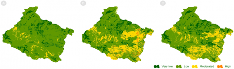
3.3 Landslide zonation
Landslide susceptibility was assessed through three different scenarios, each corresponding to a specific LULC condition. The spatial distribution of susceptibility classes is presented in Figure 5, where four susceptibility levels—very low, low, moderate, and high—are represented across the watershed. Table 3 provides the corresponding area metrics for each susceptibility class in the three scenarios.
Figure 5. Landslide model for the different scenarios
In the first scenario, before the wildfire, landslide susceptibility was predominantly classified as low, covering 15,928 hectares, followed by very low susceptibility with 2,249 hectares and moderate susceptibility extending over 721 hectares, mainly concentrated in the central zone of the watershed near stream networks. No significant areas were classified as high susceptibility, indicating relatively stable conditions before the wildfire event.
The second scenario, representing conditions immediately after the fire, shows a shift in susceptibility patterns, with an increase in moderate and high susceptibility areas due to vegetation loss and changes in soil stability. The low susceptibility class decreased to 12,073 hectares, while the moderate susceptibility area expanded to 4,418 hectares. Additionally, a high susceptibility zone emerged, covering 260 hectares, primarily in areas affected by the wildfire. These changes suggest that the fire significantly altered the landscape, increasing the likelihood of landslides in affected regions.
The third scenario, calculated two years after the fire, reflects a partial recovery of vegetation and soil conditions, leading to a redistribution of susceptibility classes. The low susceptibility class remains dominant, though reduced to 13,699 hectares, while the moderate class remains stable at 3,699 hectares. The very low susceptibility area expanded to 2,485 hectares, indicating an improvement in certain areas due to vegetation regrowth. Additionally, the high susceptibility areas show some recovery, suggesting that the reestablishment of vegetation plays a crucial role in stabilizing the landscape.
Although the proportion of the territory classified as highly vulnerable is currently limited, trends in land use and management indicate that if current practices persist, there could be a severe increase in this category, endangering the safety of the inhabitants of San Gabriel, La Guadalupe, Apango, Ojo de Agua de Apango, and La Cañada. The dynamics of LULC change reveal a net expansion of agricultural areas by 973 hectares during the study period, primarily at the expense of moderately and sparsely vegetated regions in the upper basin of the Salsipuedes River.
Avocado plantations, known as "green gold," are driving this transformation. Since 2005, production has increased due to the region's favorable conditions. Now, 42% of Jalisco's municipalities have plantations, with 70% of production in the south. By 2020, avocado farms covered 22,039 hectares, with Zapotlán El Grande (21.5%), San Gabriel (12.2%), and Tuxpan (11.6%) as the top producers [18].
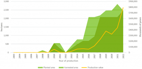
The increasing area planted with avocados aligns with the trend of expanding agricultural land use in the upper basin of the Salsipuedes River. Given the municipality's significance as a national producer and the rising demand for avocados both nationally and internationally, agricultural expansion in the basin will undoubtedly continue. Figure 6 illustrates this trend, showing the expansion of avocado plantations in San Gabriel from 2003 to 2022, with planted and harvested areas increasing significantly, particularly after 2014.
A major production surge occurred in 2019, with production volumes reaching 20,590 tonnes and yields averaging 84 percent. This rapid growth coincides with increased deforestation and fire activity, highlighting the link between agricultural expansion and environmental transformation. The data presented in Figure 6 comes from the Agri-Food and Fisheries Information Service (SIAP), a federal government institution responsible for agricultural and fisheries statistics in Mexico.
Figure 6. Yields in area planted and harvested
The expansion of avocado plantations is closely linked to increased wildfire occurrences. The use of fire as a land-clearing technique is a common yet unsustainable practice in agricultural expansion. The trend of avocado-driven deforestation correlates with an increase in fire activity, as shown in Figure 7.
Figure 7. Land cover loss due to wildfires
According to Olivares-Martinez et al. [16], the increasing intensity and frequency of wildfire use alter traditional agricultural practices, leading to physical, chemical, and biological changes in soil properties. This degradation promotes soil deterioration and increases surface runoff by up to 70 percent, accelerating water transport capacity and enhancing soil erosion. In the studied area, post-wildfire surface runoff transported large amounts of burnt organic material downslope, depositing it near San Gabriel and further destabilizing the terrain.
Most wildfires are human-induced, affecting over 400 million hectares globally each year. Climate change is projected to exacerbate this trend, with an estimated increase in wildfire frequency and intensity by 14 percent by 2030, 30 percent by 2050, and up to 50 percent by the end of the century [10].
If avocado-driven land use change in the upper basin of the Salsipuedes River continues to rely on fire as a clearing tool, and climate change further intensifies fire conditions, landslide susceptibility in the region will rise significantly. This will not only threaten the sustainability of avocado cultivation but also increase risks to society, infrastructure, and other economic activities in San Gabriel’s urban areas.
Figure 6 shows how avocado plantations have expanded significantly in the municipality of San Gabriel, Jalisco, with a rapid increase in planted and harvested areas since 2014. The production surge in 2019 aligns with increased land conversion, suggesting a direct link between agricultural expansion and environmental change. Figure 7 highlights the relationship between tree cover loss, fire-related deforestation, and wildfire frequency. The peak in fire activity recorded in 2019, coinciding with the debris flow event, underscores the role of fire-driven land use change in landscape destabilization. These figures together illustrate the broader impact of agricultural expansion on wildfire occurrence and subsequent disaster risks, reinforcing the need for sustainable land management practices in the region.
The expansion of the agricultural frontier in the studied area and the resulting changes in LULC indicate an ongoing degradation of tree cover, driven by industrialized agriculture focused on intensive production. This transformation alters not only the landscape and socio-economic conditions of local communities but also increases the risk to both the population and critical ecosystem services.
The decline in tree cover reduces the capacity for water retention and soil stability, contributing to the conditions that lead to natural disasters. The findings of this study confirm that the June 2019 debris flow in San Gabriel was not an isolated event but rather the result of cumulative land management practices, particularly deforestation and fire-based agricultural expansion, which have altered the natural balance of the landscape.
Given the current trajectory of land use change and agricultural expansion, the probability of similar events occurring with greater magnitude and intensity is increasing. The study reveals that between 2012 and 2022, deforestation and wildfire activity intensified, particularly between 2017 and 2019, when wildfires contributed to the loss of 958 hectares of tree cover. This environmental degradation, coupled with the continued expansion of avocado plantations in the upper basin of the Salsipuedes River, highlights the urgent need for integrated land management strategies that prioritize forest conservation and sustainable agricultural practices.
These findings contribute to the scientific understanding of how agricultural expansion, deforestation, and fire management practices influence disaster susceptibility. The methodology, combining satellite imagery, GIS-based modeling, and historical land use analysis, is replicable and can be applied in other regions facing similar land-use pressures. By integrating these findings into land management policies, decision-makers can better anticipate and mitigate disaster risks associated with agricultural expansion.
While challenges exist in regulating the avocado agro-industry due to its economic and social influence, proactive measures must be taken to ensure that agricultural development does not come at the expense of environmental stability. Without effective policy interventions, landslide susceptibility will continue to rise alongside agricultural expansion. Continuous monitoring and regulation of land use practices in the upper basin of the Salsipuedes River are crucial to minimizing future disasters, ensuring the long-term sustainability of agricultural production, and protecting local communities from increasing environmental risks.
In order to mitigate these risks, it is essential to implement a regulatory framework that integrates scientific monitoring, land use planning, and disaster prevention strategies. The following policy actions are recommended:
Regulating agricultural expansion – Establishing protected zones where deforestation is prohibited, particularly in high-risk areas within the upper basin of the Salsipuedes River.
Promoting sustainable farming practices – Eliminating or reducing the use of fire for land clearing, encouraging alternative land preparation techniques that do not degrade soil stability.
Implementing reforestation and soil conservation programs – Restoring areas where tree cover loss has been significant, prioritizing species that contribute to erosion control and water retention.
Strengthening land-use monitoring systems – Utilizing remote sensing and GIS-based tools to track deforestation, fire activity, and changes in vegetation cover in real-time, ensuring that early warnings can be issued when risk factors increase.
Developing community-based disaster preparedness programs – Integrating local knowledge and scientific data to enhance the resilience of at-risk populations.
Establishing early warning and monitoring systems – Using real-time land cover analysis, fire detection, and landslide susceptibility modeling to allow authorities to implement preventive measures before critical thresholds are reached.
Creating financial incentives for sustainable land management – Offering subsidies or tax benefits for farmers who adopt eco-friendly agricultural methods, including agroforestry and soil conservation techniques.
Coordinating intergovernmental efforts – Strengthening collaboration between municipal, state, and federal agencies to enforce land use regulations, implement conservation programs, and develop long-term resilience strategies against climate-induced disasters.
Enhancing community participation in land management – Encouraging local farmers and stakeholders to engage in conservation programs by providing incentives for reforestation, sustainable irrigation, and responsible land use practices.
[1] Carabella, C., Miccadei, E., Paglia, G., Sciarra, N. (2019). Post-wildfire landslide hazard assessment: The case of the 2017 Montagna del Morrone fire (Central Apennines, Italy). Geosciences, 9(4): 175. https://doi.org/10.3390/geosciences9040175
[2] Centro Nacional de Prevención de Desastres. (2019). Factores detonantes de inestabilidad de laderas. https://www.gob.mx/cenapred/articulos/factores-detonantes-de-inestabilidad-de-laderas.
[3] Di Napoli, M., Marsiglia, P., Di Martire, D., Ramondini, M., Ullo, S.L., Calcaterra, D. (2020). Landslide susceptibility assessment of wildfire burnt areas through earth-observation techniques and a machine learning-based approach. Remote Sensing, 12(15): 2505. https://doi.org/10.3390/rs12152505
[4] Nunes, J.P., Bernard-Jannin, L., Rodríguez-Blanco, M.L., Boulet, A.K., Santos, J.M., Keizer, J.J. (2020). Impacts of wildfire and post-fire land management on hydrological and sediment processes in a humid Mediterranean headwater catchment. Hydrological Processes, 34(26): 5210-5228. https://doi.org/10.1002/hyp.13926
[5] Ledesma, M.M., Rodriguez, M.J., Torres, R.M. (2023). Evaluación de geoindicadores espectrales temporales de los eventos de incendios de interfase del 2009 y 2020 en el área de influencia de Achiras, Córdoba, Argentina. http://biblio.unvm.edu.ar/opac_css/index.php?lvl=cmspage&pageid=9&id_notice=45003.
[6] Lagarda, A.M., Rosales, A.B., Cambranis, R.M. (2023). La construcción social del riesgo en laderas volcánicas. el caso del Chiquihuite en la Ciudad de México. Revista de Estudios Latinoamericanos sobre Reducción del Riesgo de Desastres REDER, 7(2): 57-72. Https://doi.org/10.55467/reder.v7i2.124
[7] Gallardo, R.J. (2019). Identification of conditioning and triggers factors of mass removal processes in the city of Ocaña, Colombia. Journal of Physics: Conference Series, 1409(1): 012020. https://doi.org/10.1088/1742-6596/1409/1/012020
[8] Farfán Gutiérrez, M., Pérez-Salicrup, D.R., Flamenco-Sandoval, A., Nicasio-Arzeta, S., Mas, J.F., Ramírez Ramírez, I. (2018). Modeling anthropic factors as drivers of wildfire occurrence at the Monarch Butterfly Biosphere. Madera y Bosques, 24(3): e2431591. https://doi.org/10.21829/myb.2018.2431591
[9] FAO. (2022). Versión resumida de El estado de los bosques del mundo 2022. Food and Agriculture Organization of the United Nations, Roma, Italia. https://doi.org/10.4060/cb9363es
[10] FAO. (2023). Nuestros bosques siguen quemandose - FO: LACFC/2023/7. Food and Agriculture Organization of the United Nations, Roma, Italia. https://openknowledge.fao.org/handle/20.500.14283/cc6237es.
[11] González-Rosales, A., Ortiz-Paniagua, C.F. (2022). Superficie forestal afectada por incendios en México: Apuntes iniciales hacia un modelo de manejo preventivo. Revista de Ciencias Ambientales, 56(1): 1-27. https://doi.org/10.15359/rca.56-1.1
[12] CONABIO. (2024). Sistema de alerta temprana ante incendios en México. Puntos de calor y áreas quemadas. http://terra2.conabio.gob.mx/historico/index.html.
[13] Jalisco con Bosques. (2022). Informe de resultados - Programa de prevención y combate de incendios 2022. https://semadet.jalisco.gob.mx/sites/semadet.jalisco.gob.mx/files/presentacion_incendios_2022_cierre_estiaj.pdf.
[14] Fontúrbel, T., Carrera, N., Vega, J.A., Fernández, C. (2021). The effect of repeated prescribed burning on soil properties: A review. Forests, 12(6): 767. https://doi.org/10.3390/f12060767
[15] Nyman, P. (2013). Post-fire debris flows in southeast Australia: initiation, magnitude and landscape controls. Doctoral dissertation, University of Melbourne, Melbourne School of Land and Environment.
[16] Olivares-Martinez, L.D., Gomez-Tagle, A., Mataix-Solera, J. (2023). Ground fire legacy effects on water-dynamics of volcanic tropical soils. Spanish Journal of Soil Science, 13: 11757. https://doi.org/10.3389/sjss.2023.11757
[17] INEGI. (2020). Censo de Población y Vivienda 2020. https://www.inegi.org.mx/programas/ccpv/2020/.
[18] IIEG. (2022). Puerto vallarta, diagnóstico municipal. https://iieg.gob.mx/ns/wp-content/uploads/2023/08/Puerto-Vallarta-2.pdf.
[19] IIEG. (2018). Geología_Unidades litológicas. https://iieg.gob.mx/ns/?page_id=1224.
[20] IIEG. (2018). Edafologia. https://iieg.gob.mx/ns/?page_id=1227.
[21] Servicio de Información Agroalimentaria y Pesquera. (2024). Producción agrícola. https://www.gob.mx/siap/acciones-y-programas/produccion-agricola-33119.
[22] López, F.J.A., Avi, J.R., Fernández, M.V.A. (2018). Control estricto de matrices de confusión por medio de distribuciones multinomiales. Geofocus: Revista Internacional de Ciencia y Tecnología de la Información Geográfica, (21): 215-226. https://doi.org/10.21138/GF.591
[23] Anbalagan, R. (1992). Landslide hazard evaluation and zonation mapping in mountainous terrain. Engineering geology, 32(4): 269-277. https://doi.org/10.1016/0013-7952(92)90053-2
[24] Anbalagan, R., Chakraborty, D., Kohli, A. (2008). Landslide hazard zonation (LHZ) mapping on meso-scale for systematic town planning in mountainous terrain. Journal of Scientific & Industrial Research, 67: 486-497.