Faris Ataallah Matloob*![]() | Khalid J. Aldeen Ismail
| Khalid J. Aldeen Ismail![]() | Ahmed A. Alfakhry
| Ahmed A. Alfakhry![]()
© 2024 The authors. This article is published by IIETA and is licensed under the CC BY 4.0 license (http://creativecommons.org/licenses/by/4.0/).
OPEN ACCESS
Given the role of walking in improving the quality of life and creating livable communities, the issue of walkability in the built environment has been given a lot of attention by researchers, particularly in the fields of urban design and planning. However, there is still a lack of objective evidence on how the built environment encourages people to walk, what features could influence walkability and how to measure this correlation. This study aims to research the link between accessibility as a key built environment feature and walkability. It is thus aimed at finding out how access to services and utilities can affect walkability at neighborhood scale. Quantitative methods have been used to gather, prepare and analyze data, which include place syntax technique, GIS, space syntax technique, gate count technique and Person correlation analysis. Findings disclosed a relationship between the accessibility of daily services and the number of people who use walking as a transport mode. Results proved that the provision of shops in suitable proximity form residences can encourage people to walk.
walkability, accessibility, urban, planning, syntax, place
Transforming cities into more walkable environments has recently become an argent aim all over the world. This is due to the fact that providing an appropriate environment for people to walk is a key issue in achieving urban sustainability [1, 2]. According to Lako and Gjevori [3], promoting walking is one of the effective means that leads to reduce emissions in cities as it diminishes car reliance. Thus, enhancing walkability turns out to be an indispensable step towards making cities more livable and humanitarian. Walkability can be generally defined as the extent to which a built environment can encourage people to mobile by walking to reach their different destinations [4, 5]. As walking correlates with numerous aspects of a built environment design and planning as well as with human circumstances and senses, walkability is deemed a complicated issue to study and research. It is argued that one of the most important disincentives of walking is the lack of physical accessibility that urban areas suffer from [6]. When the access to a place is looked at in terms of the metric distance, this could more relate to residents’ daily services and needs in the city or town, where planning and spatial equity are key factors in this issue. So, this study seeks to objectively disclose the relationship between the difficulty of accessing different locations and people's tendency to use walking instead of private vehicles.
Extensive research has been done by experts and researchers in urban design and planning with the aim to introduce a deeper understanding of how walkability correlates with different aspects of a built environment design and planning. However, numerous such studies have concentrated on the design qualities of a place that might influence walking conditions and ease of movement and then encourage or discourage people to walk [6-9]. Others have directed to study the issue at a wider scale focusing on urban morphology and how the configuration of urban fabric can impact walkability [10-12]. Some studies have indicated that some accessibility properties such as direction changes and distance might influence pedestrian's choice of route to their destinations [13, 14]. Nevertheless, insufficient work has been done to study whether residents’ decisions to move by walking are affected by the accessibility to important destinations especially the services and needs within neighborhood. In other words, there is a lack of searching whether the difficulty in getting to important daily services represents influential factor that might influence pedestrian's decision to walk or use another mode of transport. Indeed, this concerns the relationship between accessibility and walkability in urban areas, which needs more focus in research and analysis. Therefore, this study attempts to answer the research question: how does the accessibility to daily needs and services encourage or discourage people to walk?
Accessibility has been defined as the term that expresses spatial– social relationship between one space with other spaces in an urban structure [15-18]. Furthermore, Talen and Anselin [19] tended to define accessibility as a measure of spatial equity, which expresses the locational distribution of services and facilities in relation to the locational distribution of different social groups in urban areas. Handy [20] correlated accessibility with the efforts people make to reach their destinations that accessibility refers to people’s ability to reach their various destinations such as services, activities, individuals or opportunities by travelling to the positions those activities are located in. It is therefore true to say that aspects such as the spatial distribution of destinations, the ease to reach them and the quality of the activities existing at the destination might act as key features in this issue [21, 22]. Thus, the spatial proximity or the distance to a destination is a crucial factor accessibility draws upon.
Walkability expresses the extent to which a built environment is able to encourage people to walk by connecting them with diverse destinations within a rational amount of effort and time, as well as offering route network characterized by safety, comfort and visual interest. Several pieces of research have interrelated between the walkable built environment and the extent of accessibility to the daily facilities the area enjoys. In this respect, such studies described a walkable built environment as one that owns an accessible pattern of activities to serve daily needs, where people can reach most local services within a range of approximately 1/4-1/5 mile in about 5-10 minutes on foot [22-26]. In line with this, Hillier and Iida [27] and Vale et al. [28] attributed this association to pedestrian’s tendency to do minimum effort when seeking their daily needs with no need to use other means of travel, where they argued that when a place is described as accessible, this indicates that it is linked well to other parts of the area, which makes it easier for them to reach it and thus be able to attract more walking people. However, the majority of studies that have researched active accessibility measured a single variable: the ability of a person to get to a destination by either walking or cycling, with no efforts to objectively measuring the real relationship between them.
This could also be deemed as an influential factor in a person’s behavior that is pointed to by Forsyth [8] who revealed that people choose walking as a mode of transport in built environments that characterized by higher densities and accessible destinations. In this regard, some studies have used accessibility indicators to study walkability at neighborhood environment such as Suarez-Balcazar et al. [29] and Hernandez et al. [30] who asked residents for information related to aspects such as walking time to several types of destinations in the neighborhood, the satisfaction of the respondents with the access to services and the infrastructure of streets, walking and cycling. Nevertheless, these studies have not focused on how walkability is directly affected by the ease of access to utilities, which would be covered by this study. However, this objective was pointed to by Abley et al. [5] and other similar studies that concluded that an environment of poor design and quality might contribute to reduce individuals’ propensity to walk. Nevertheless, such studies depend merely on qualitative measures relying on people’s perceptions of walking environment.
Other groups of studies tended to study accessibility in terms of the configuration and morphology of the built environment, of which, space syntax research relies on syntactic and topologic analyses of urban fabric. Those studies attempted to use two syntactical space syntax properties to express accessibility, namely integration and connectivity [11, 12, 31]. Integration index determines how easy it is to move from one space to all other spaces in urban system. So, it represents a closeness measure of the network expressing accessibility by a syntactical measure. As for connectivity index, it is also used in the researches dealing with accessibility and walkability of urban areas as it measures the number of spaces that are directly linked to a specific space in the network. It expresses the directness of an urban system in syntactical way also [12, 32, 33].
However, researching walkability in order to acquire more objectivity, might require to consider geographical accessibility, meaning that accessibility that is defined by metric distance towards specific destinations, which is adopted by the current study. According to Ståhle et al. [34], space syntax research when it comes to analyze pedestrian mobility, has shown the need for more people-based knowledge. Hence, this study has drawn on a methodology represented by place syntax tool (PST) that has introduced a possibility to combine the space syntax properties of the cognitive environment, e.g. topological distance represented by axial steps measured in changes of directions, with conventional depiction of attraction into accessibility analysis. In addition, accessibility in the studies adopting space syntax is measured within the network with no attractions. So, place syntax technique has added attractions to this methodology, where locations can be measured by actual travel distance [35]. Therefore, this study attempts to fill this research fills some of the knowledge gap represented by a lack in the research that incorporate accessibility quantitatively measured by walking distance to walkability analysis. This study explores how choosing travel mode is affected by the configurational properties of urban fabric in neighborhood context namely, accessibility measured by real walking distance to daily utilities and opportunities.
This study attempts to answer the research question: how do the urban configuration features of Mosul city neighborhoods impact urban walkability? Hence, the specific aim of the study is to find out whether the ease of access to the destinations containing people’s daily needs can influence their decision to walk. In order to meet its aim, the study adopted a quantitative methodology that relies upon analyzing geographic accessibility metrically measured, while measuring walkability depending on pedestrian flow in the studied areas.
Accessibility analyses in this study are performed by place syntax strategy using place syntax tool (PST) working within a GIS environment, where it is used as a plugin on QGIS software. Place syntax technology has made it possible to combine the space syntax description of urban environment with geographical descriptions of attractions into a combined accessibility analysis. Thus PST has unlocked a sequence of possible accessibility analyses [34, 36]. According to them, in its theory, the place syntax model has relied upon standard accessibility models of contemporary GIS research. The accessibility A in the location i is as Eq. (1):
$A i=\sum f(W i, d i j)$ (1)
where, Wj is a measure of the attraction at the locations j and dij is a measure of distance from the location i to the locations j.
This approach allows analyzing geographic accessibility to certain attractions with axial or segment lines in GIS, which represents an effective way for handling spatial complexity of a realistic urban environment. In other words, place syntax strategy has combined between two approaches in analyzing urban environments: geographical approach and space syntax metrics. In order to perform place syntax analysis, axial maps of the studied areas are created using DepthmapX software. Axial-line diagram is defined by Hillier [37] as: “the fewest and longest straight lines of sight and access which cover the area of interest”.
As accessibility expresses how it is easy to reach specific destinations, which is where the services and utilities in urban fabric are, it concerns distances between those important activities that people daily need, on the one hand, and all other spaces within the system, on the other hand. Those activities include varied destinations such as shops and supermarkets, schools, parks, public transport stations, worship places, health centers, and so on, which are required to be located within suitable walking distance for most residents in a neighborhood. However, for this study, in order to limit the study and avoid prolongation, only one type was chosen to analyze as the most important destination people need to reach during their daily lives, namely shops and supermarkets. This is because at neighborhood level commonly, shops provide a range of items for people as daily needs. Accordingly, the operational definition of shops for this study is: food stores for retail located within the study area whether small, medium or big, that are specializing in sale of food and other household needs. Results of PST analysis are handled within QGIS environment and then presented graphically and statistically as QGIS outputs.
Walkability as a dependent variable in this study is represented by pedestrian flow measures. The adopted method to execute this measure is (Gate Counts) strategy that’s frequently applied by numerous urban studies [38]. According to this method, recording observations of pedestrian movement flows in a built area is done. The process is executed by first defining the boundary of the area under scrutiny including spaces of well, moderately and poorly used. Secondly, the number and positions of the gates should be selected. It is useful that gate positions are determined manually on the map to be followed when walking through the studied area. As for the number of gates, it is suggested by Grajewski and Vaughan [39] that the minimum number of gates is 25 per area and the more the better. At each gate position, an imaginary line is drawn across the street including pavements. The observer then counts and registers only pedestrians crossing the line. Gates positions can be selected according to the results of other analyses. Collected data can be represented statistically or graphically in various ways. The period of each gate observation is 5 minutes, so, in a period of 1 hour, the observer can cover 10 gates consuming 50 minutes, while the remaining 10-min are allocated to move towards the next gate [38]. For this study, the same procedure is adopted, thus, a number of 25 gates is designated for each case study. Correlation analyses are conducted by using SPSS statistical package, where Pearson’s correlation analysis is employed.
3.1 Case study
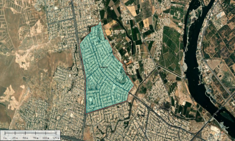
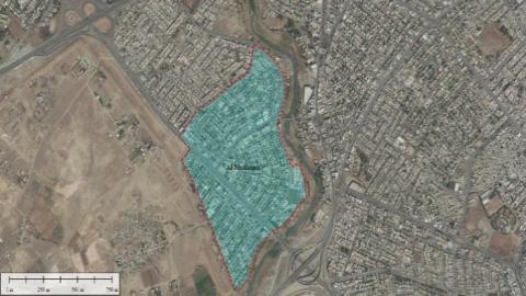
For conducting the analyses of the field study, two neighborhoods in Mosul were selected, namely Tammouz and Al-Muthanna. As is known, the city of Mosul is divided by the Tigris River into two sides locally known as the right side and the left side. While Tammouz is located on the right side of the city, Al-Muthanna is situated on the left side. Areas of the selected case studies are 1.335 sq. km and 0.705 sq. km respectively. As for urban structure, Mosul is generally characterized by regular gridded urban structures for most of its neighborhoods except that for the historical city district. However, in order to add an extent of objectivity to the analyses, the selection of the two case studies above mentioned is based on the existence of some differences regarding urban fabric morphology. While Tammouz is characterized by a fully regular grid layout, Al-Muthanna has some extent of semi-deformed urban fabric. What should be noted is that services and utilities in most of Mosul neighborhoods do not follow a pattern of grouping in the central area, which is a prevailing pattern in the city including both case studies (Figures 1 and 2).
Figure 1. Tammuz neighborhood urban fabric
Figure 2. Al-Muthanna neighborhood urban fabric
In order to meet the goal of the study determined to find out whether walkability is affected by configurational features at neighborhood scale, and to answer the study question formulated as: how does the accessibility to daily needs and services encourage or discourage people to walk? Where accessibility here is represented by the ease of access to shops. Features of the two selected case studies are analyzed graphically and statistically. The results and discussions are as below.
Accessibility analyses are performed using place syntax tool (PST) within geographic information system represented by (QGIS) application. This method has been chosen for this study because it introduces objective measurements of accessibility in the study areas as it enables measuring the proximity of the destinations as metric distances from all points of the urban system. Based on the foregoing, in this study, PST approach is used to measure accessibility as metric distances to all daily utilities and services in the case study areas. This would give more objectivity when studying accessibility. This was applied by Ståhle [40] and Dastoli [41]. Then the results of PST are correlated with the other phenomenon, namely walkability using Person’s correlation.
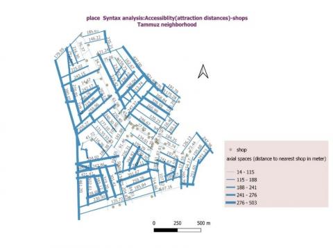
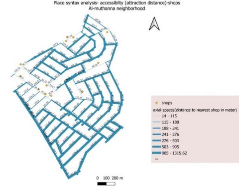
Figures 3 and 4 show place syntax analysis for both case studies, namely Tammuz and Al-Muthanna respectively, where each line represents a path or street in the urban system, while points represent shops. Accessibility measure generated by using PST is expressed by the distance to the nearest shop from each space in the system. According to the analyses, distances are expressed by the thickness of the line representing a space, where the nearer the distance from a space center to a closer shop, the lighter the thickness of the line. This is based on numeric values of metric distances. Graphically, a comparison between the resulting maps of the two case studies can obviously show that the amount of lighter lines in Tammuz neighborhood is greater than that of Al-Muthanna. This suggests that Tammuze system possesses better accessibility to shops. This might be attributed to better distribution and greater numbers of shops in Tammuz compared to Al-Muthanna. It could also be interpreted that the configuration of Tammuze system helps a more balanced accessibility.
This is reinforced by statistic values of the analysis, where the mean value of the distances between all spaces and nearest shops of Tammuze whole system was recorded at 208.02 meters while that of Al-Muthanna district was revealed to have a greater value of 391.26 meters (Table 1). This discloses that shops in Tammuz are more accessible than those in Al-Muthanna. In other words, people on foot have to walk longer distances and then make more efforts in order to reach their daily needs in Al-Muthanna compared with Tammuz. This could discourage people from walking in order of such tasks and as a result, they might instead tend to use private vehicles.
Moreover, values of maximum distances of the two case studies in turn give additional evidence on to what extent the access to shops is easy or difficult for pedestrians. PST analyses showed that the maximum walking distance to nearest shop in Tammuze neighborhood was 502.6 meters, while the value for Al-Muthanna was 1315.6 meters (Table 1). The greater value of Al-Muthanna points to worse accessibility compared with Tammuz.
On the other hand, in order to link accessibility results with walkability, they should be looked at alongside the results of gate count analyses. Results of pedestrian flow survey obtained by the technique of gate counts on site for 25 axial spaces for each district disclosed interesting results. As shown in Table 1, Tammuz recorded greater mean value of pedestrian count with 7.84 persons, whereas Al-Muthanna recorded a value of 3.72 persons. These results indicate that walkability in Tammuz is better than in Al-Muthanna showing an inverse proportion to the values of accessibility of both studied areas, what can be interpreted that the greater the distances walked, the worse the walkability. The forgoing denotes a noteworthy relationship between accessibility and walkability in the neighborhood level, where better accessibility could lead to a better ability of a built environment to encourage people to walk. This can contribute to answering the research question as it clarifies how ease of access influences people’s tendency to walk in order to meet their daily needs. This was pointed to by numerous reviewed literature such as literatures [5, 6, 12].
Figure 3. Accessibility to the nearest shop in Tammuz
Figure 4. Accessibility to the nearest shop of Al-Muthanna
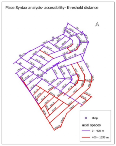
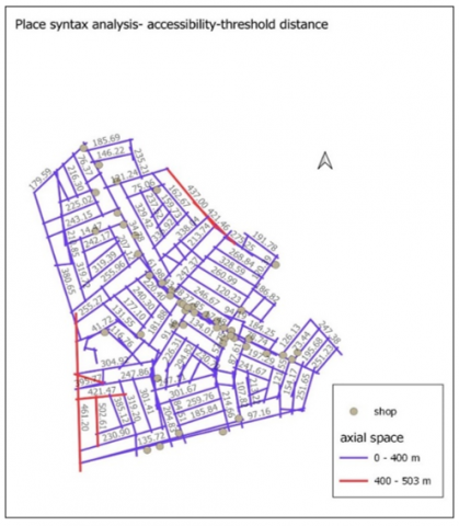
Another check can be done here, that is related to the thresholds of distances, which is deemed an essential indicator to measure acceptable accessibility in urban areas. According to Girling and Kellett [42], Porta and Renne [23], Song and Knaap [43] and Kellett et al. [25], a benchmark of acceptable or comfortable walking distance ranges between (¼ - ½ mile) or 5- 10 minute- walk. Moreover, the Iraqi urban housing standards manual designated a distance of 200-500 meters as a maximum walking distance from houses to corner shops and local markets respectively [44]. Based on the above, using place syntax tool (PST), the analyses of accessibility (attraction distance) of the two case studies were repeated but with adopting a maximum distance of 400 meters as a benchmark distance to the nearest shop. Figures 5 and 6 show graphical results of Al-Muthanna and Tammuz respectively, where distances of 400 meters or less are in blue color, while distances that exceed 400 meters are shown in red. A comparison between the two figures can obviously show that Al-Muthanna possesses a greater amount of red lines that are spaces of over 400 meters (Figure 5), compared with Tammuz (Figure 6). This indicates that shops in Tammuz are enjoying better accessibility.
Statistically, Results disclosed that Tammuz recorded a higher percentage of 96.6 of spaces 400 meters or less from the nearest shop, compared with Al-Muthanna which showed 59.8 percent (Table 1). When the graphical and statistical results are looked at alongside the mean values of pedestrian counts for both studied areas, which were 7.84 and 3.72 for Tammuz and Al-Muthanna respectively, they obviously unveil a compatibility with what was proven above. In other words, the results suggest a causal relationship between accessibility and walkability, that is the ease of access to daily needs represented here by shops can affect the numbers of people on foot in urban areas. This formulates additional support towards understanding the relationship between the ease of access to daily destinations and walkability, which answers the research question: how does the accessibility to daily needs and services encourage or discourage people to walk?
In order to more deeply understand the nature of the relationship between accessibility and walkability, Pearson’s correlation analysis using SSPS software is executed. This method was chosen to be used in this study as it is commonly used as a suitable statistical method in urban planning research to correlate parametric variables such as [45, 46].
The analysis is carried out between data of the access to the nearest shop obtained by place syntax analyses on one hand and walking data obtained by gate counts technique on site on the other hand. Tables 2 and 3 present the correlation between the two variables for both Tammuz and Al-Muthanna respectively. According to the tables, correlation coefficient (Pearson’s r) recorded -0.708 for Tammuz and -0.749 for Al-Muthanna. Pearson’s r measures the strength and direction of linear relationships between pairs of continuous variables [47]. As both values are fairly close to 1, this indicates a rather strong relationship between accessibility to the nearest shop and the pedestrian count in the surveyed paths for both case studies. This means that changes in accessibility values are rather strongly correlated with changes in the numbers of people on foot in both case studies.
Negative Pearson’s r values for both districts suggest an inverse relationship between the values of the two variables, namely distances and pedestrian numbers, meaning that, when distances to the nearest shop increase, the numbers of walking people decrease and vice versa. In other words, the better the accessibility to daily needs, the better the walkability on neighborhood scale.
This is compatible with the results of the descriptive analysis above mentioned. Furthermore, according to Tables 2 and 3, the Sig. (2-tailed) or ρ values for both case studies recorded 0.000 which is less than 0.05 indicating a statistically significant correlation between the two variables. This designates that increases or decreases in accessibility values do significantly relate to increases or decreases in the numbers of people on foot in the studied areas. This can be attributed to that individuals’ propensity to walk may reduce with poor accessibility towards daily destinations as also concluded by Abley et al. [5], which pushes towards meeting the study aim: understanding the relationship between accessibility and walkability. Consequently, it can be said that accessibility could be one of the significant factors that affect the decision of people to walk as transportation means within neighborhood level.
Figure 5. PST analysis of accessibility with threshold distance of 400 m- Al-Muthanna
Figure 6. PST analysis of accessibility with threshold distance of 400 m- Tammuz
Table 1. Accessibility and walkability measures
|
Analysis Figures |
Tammuz |
Al-Muthanna |
|
Distance mean to nearest shop (meter) |
208.02 |
391.26 |
|
Maximum distance to nearest shop (meter) |
502.60 |
1315.62 |
|
Pedestrian count mean (person) |
7.84 |
3.72 |
|
Percentage of spaces of less than 400 meters distance from nearest shop |
96.6 |
59.8 |
Table 2. Person’s correlation for Tammuz measures
|
|
Distance |
Pedestrian |
|
|
Distance |
Pearson Correlation |
1 |
-.708** |
|
Sig. (2-tailed) |
|
.000 |
|
|
N |
29 |
29 |
|
|
Pedestrian |
Pearson Correlation |
-.708** |
1 |
|
Sig. (2-tailed) |
.000 |
|
|
|
N |
29 |
29 |
|
Table 3. Person’s correlation for Al-Muthanna measures
|
|
Distance |
Pedestrian |
|
|
Distance |
Pearson Correlation |
1 |
-.749** |
|
Sig. (2-tailed) |
|
.000 |
|
|
N |
25 |
25 |
|
|
Pedestrian |
Pearson Correlation |
-.749** |
1 |
|
Sig. (2-tailed) |
.000 |
|
|
|
N |
25 |
25 |
|
From sustainability point of view, the walkability of an urban area is significant for the quality of life of the society. This is because walking is deemed the best means of travel as it is the cleanest, the healthiest, the cheapest and the most sociable mode of transport. Hence it has the ability to affect communities environmentally, economically and socially.
Attention has been paid to many studies to research if there is a link between built environment features and walking behavior, but there is still a lack of what aspect of built environment planning and design has an important influence on people decision to prefer walking as a means of transport [8, 48]. Hence, this study concentrated on accessibility as a key planning feature that needs to be objectively researched in terms of its potential impact on walkability. This study is aimed at finding out to what extent the ease of access to daily needs can encourage people to walk at neighborhood level, hence attempting to quantitatively research such a relationship. According to the analysis results mentioned above, it was descriptively and statistically proven that there is an obvious relationship between the existence of shops in suitable proximity to residential spaces and the number of people who walk. This means that making places more accessible for all people can increase the opportunity for walking. More precisely, the study has found that the more accessible shops in a neighborhood, the more people walk to get their daily needs.
This can be attributed to that people prefer walking over the use of a private vehicle if the effort required to walk is within the acceptable range. Conversely, the use of private automobiles becomes the preferred means for people to move when the distance to the nearest destination exceeds the benchmark of acceptable walking distance. This is supported by what Hillier and Hanson [49] argued that people prefer to walk taking “the shortest and fastest” routes towards destinations such as retail shops or mixed use areas. It can be said that this study has introduced empirical and objective evidence toward a better understanding of how accessibility of destinations affects walkability. This means that providing services within suitable distances from residences can deliver people with a choice to use walking as a means to get their daily needs such as food. In fact, this is related to the spatial configuration of the urban area and the way utilities are located and distributed within the area.
However, to avoid prolongation, this study has been limited by choosing only one destination, namely shops from a list of urban destinations in the neighborhood, which could affect the generalizability of the results. Taking the findings of this study into consideration, future research could be directed towards the triangulation of the methods using quantitative and qualitative methods and considering other factors related to walkability such as users’ perceptions and the quality of public realm for the pedestrians’ paths leading to a set of destinations.
To conclude, the findings of this study could be used as a guide for planners, urban designers and decision makers when planning or developing neighborhoods or urban areas. This guide can be abbreviated that a walkable neighborhood should possess an accessible pattern of activities to serve daily needs so that one can reach most local-serving uses, particularly shops and groceries on foot within 200-500 meters. Indeed, this issue is related to spatial justice that requires making most people in suitable proximity to services and utilities particularly daily ones that encourage people to choose walking as a movement mode towards their needs. This could automatically cause diminishing private car reliance, which, in turn, positively reflects on the quality of life, as the built environment would get rid of many negative effects of using motorized vehicles.
[1] Forsyth, A., Southworth, M. (2008). Cities afoot—Pedestrians, walkability and urban design. Journal of Urban Design, 13(1): 1-3. https://doi.org/10.1080/13574800701816896
[2] Karlström, A., Mattsson, L.G. (2009). Place, space syntax and attraction-accessibility. In Proceedings of the 7th International Space Syntax Symposium. Stockholm: KTH.
[3] Lako, A., Gjevori, S. (2023). Urban public transport as a basis for sustainable mobility development in the transition from private vehicles to urban public transport: A case study of Elbasan. International Journal of Sustainable Development & Planning, 18(11): 3609-3615. https://doi.org/10.18280/ijsdp.181126
[4] Jenks, M., Jones, C. (2009). Dimensions of the Sustainable City. London, Springer.
[5] Abley, S., Turner, S., Singh, R. (2011). Predicting Walkability. Wellington: NZ Transport Agency.
[6] Barrera-Fernández, D., Hernández-Escampa, M. (2022). Mobility in urban events: Walkability and accessibility in the Guelaguetza. Annals of Leisure Research, 25(2): 247-272. https://doi.org/10.1080/11745398.2020.1800497
[7] Farkić, J., Perić, D., Lesjak, M., Petelin, M. (2015). Urban walking: Perspectives of locals and tourists. Geographica Pannonica, 19(4): 212-222. https://doi.org/10.5937/GeoPan1504212F
[8] Forsyth, A. (2015). What is a walkable place? The walkability debate in urban design. Urban Design International, 20: 274-292. https://doi.org/10.1057/udi.2015.22
[9] Hooi, E., Pojani, D. (2020). Urban design quality and walkability: An audit of suburban high streets in an Australian city. Journal of Urban Design, 25(1): 155-179. https://doi.org/10.1080/13574809.2018.1554996
[10] Cambra, P.J.M.D. (2012). Pedestrian Accessibility and Attractiveness Indicators for Walkability Assessment. Urbanism and Spatial Planning, Tecnico Lisboa. MSc.
[11] Barros, A.P., Martínez, L.M., Viegas, J.M. (2017). How urban form promotes walkability? Transportation Research Procedia, 27: 133-140. https://doi.org/10.1016/j.trpro.2017.12.039
[12] Roozkhosh, F., Molavi, M., Salaripour, A. (2020). Comparison of walkability in different urban districts using space syntax. Journal of Architecture and Urbanism, 44(1): 1-10. https://doi.org/10.3846/jau.2020.6587
[13] Marquet, O., Miralles-Guasch, C. (2014). Walking short distances. The socioeconomic drivers for the use of proximity in everyday mobility in Barcelona. Transportation Research Part A: Policy and Practice, 70: 210-222. https://doi.org/10.1016/j.tra.2014.10.007
[14] Shatu, F., Yigitcanlar, T., Bunker, J. (2019). Shortest path distance vs. least directional change: Empirical testing of space syntax and geographic theories concerning pedestrian route choice behaviour. Journal of Transport Geography, 74: 37-52. https://doi.org/10.1016/j.jtrangeo.2018.11.005
[15] Koh, P.P., Wong, Y.D. (2013). Influence of infrastructural compatibility factors on walking and cycling route choices. Journal of Environmental Psychology, 36: 202-213. https://doi.org/10.1016/j.jenvp.2013.08.001
[16] Jeong, S.K., Ban, Y.U. (2016). A point-based angular analysis model for identifying attributes of spaces at nodes in street networks. Physica A: Statistical Mechanics and its Applications, 450: 71-84. https://doi.org/10.1016/j.physa.2015.12.068
[17] Van Wee, B. (2016). Accessible accessibility research challenges. Journal of Transport Geography, 51: 9-16. https://doi.org/10.1016/j.jtrangeo.2015.10.018
[18] Jabbari, M., Fonseca, F., Ramos, R. (2021). Accessibility and connectivity criteria for assessing walkability: An application in Qazvin, Iran. Sustainability, 13(7): 3648. https://doi.org/10.3390/su13073648
[19] Talen, E., Anselin, L. (1998). Assessing spatial equity: An evaluation of measures of accessibility to public playgrounds. Environment and Planning A, 30(4): 595-613. https://doi.org/10.1068/a300595
[20] Handy, S. (2005). Planning for accessibility: In theory and in practice. In Access to Destinations, pp. 131-147. https://doi.org/10.1108/9780080460550-007
[21] Handy, S.L., Niemeier, D.A. (1997). Measuring accessibility: An exploration of issues and alternatives. Environment and Planning A, 29(7): 1175-1194. https://doi.org/10.1068/a291175
[22] De Vos, J., Lättman, K., Van der Vlugt, A.L., Welsch, J., Otsuka, N. (2023). Determinants and effects of perceived walkability: A literature review, conceptual model and research agenda. Transport Reviews, 43(2): 303-324. https://doi.org/10.1080/01441647.2022.2101072
[23] Porta, S., Renne, J.L. (2005). Linking urban design to sustainability: Formal indicators of social urban sustainability field research in Perth, Western Australia. Urban Design International, 10: 51-64. https://doi.org/10.1057/palgrave.udi.9000136
[24] Southworth, M. (2005). Designing the walkable city. Journal of Urban Planning and Development, 131(4): 246-257. https://doi.org/10.1061/(ASCE)0733-9488(2005)131:4(246)
[25] Kellett, R., Fryer, S., Budke, I. (2009). Specification of indicators and selection methodology for a potential community demonstration project. Retrieved November, 29: 2012.
[26] Bhattacharyya, D.B., Mitra, S. (2013). Making Siliguri a walkable city. Procedia-Social and Behavioral Sciences, 96: 2737-2744. https://doi.org/10.1016/j.sbspro.2013.08.307
[27] Hillier, B., Iida, S. (2005). Network effects and psychological effects: A theory of urban movement. In Proceedings of the 5th International Symposium on Space Syntax, pp. 553-564.
[28] Vale, D.S., Saraiva, M., Pereira, M. (2016). Active accessibility: A review of operational measures of walking and cycling accessibility. Journal of Transport and Land Use, 9(1): 209-235. https://www.jstor.org/stable/26203215
[29] Suarez-Balcazar, Y., Early, A.R., Garcia, C., Balcazar, D., Arias, D.L., Morales, M. (2020). Walkability safety and walkability participation: A health concern. Health Education & Behavior, 47(3): 430-438. https://doi.org/10.1177/1090198120903256
[30] Hernandez, R., Kershaw, K.N., Prohaska, T.R., Wang, P.C., Marquez, D.X., Sarkisian, C.A. (2015). The cross-sectional and longitudinal association between perceived neighborhood walkability characteristics and depressive symptoms in older Latinos: The “¡ Caminemos!” study. Journal of Aging and Health, 27(3): 551-568. https://doi.org/10.1177/0898264314553211
[31] Baran, P.K., Rodríguez, D.A., Khattak, A.J. (2008). Space syntax and walking in a new urbanist and suburban neighbourhoods. Journal of Urban Design, 13(1): 5-28. https://doi.org/10.1080/13574800701803498
[32] Bahrainy, H., Khosravi, H. (2013). The impact of urban design features and qualities on walkability and health in under-construction environments: The case of Hashtgerd New Town in Iran. Cities, 31: 17-28. https://doi.org/10.1016/j.cities.2013.01.001
[33] Dettlaff, W. (2014). Space syntax analysis–methodology of understanding the space. PhD Interdisciplinary Journal, 1: 283-291.
[34] Ståhle, A., Marcus, L., Karlström, A. (2005). Place syntax: Geographic accessibility with axial lines in GIS. In Fifth International Space Syntax Symposium, pp. 131-144.
[35] Ståhle, A. (2012). Place syntax tool (PST). Accessibility Instruments for Planning Practice, 173-178.
[36] Ståhle, A. (2008). Compact sprawl: Exploring public open space and contradictions in urban density. Doctoral dissertation, KTH.
[37] Hillier, B. (2007). Space is the Machine: A Configurational Theory of Architecture. Space Syntax.
[38] van Nes, A., Yamu, C. (2021). Introduction to space syntax in urban studies. Springer Nature.
[39] Grajewski, T., Vaughan, L. (2001). Space Syntax Observation Manual. UCL Bartlett and Space Syntax Limited, London.
[40] Ståhle, A. (2010). More green space in a denser city: Critical relations between user experience and urban form. Urban Design International, 15: 47-67. https://doi.org/10.1057/udi.2009.27
[41] Dastoli, P. (2022). A place syntax approach to fifteen Minutes cities. In 13th International Space Syntax Symposium, Bergen in Norway, Western Norway University of Applied Sciences (HVL), pp. 1-17.
[42] Girling, C., Kellett, R. (2002). Comparing stormwater impacts and costs on three neighborhood plan types. Landscape Journal, 21(1): 100-109. https://doi.org/10.3368/lj.21.1.100
[43] Song, Y., Knaap, G.J. (2004). Measuring urban form: Is Portland winning the war on sprawl? Journal of the American Planning Association, 70(2): 210-225. https://doi.org/10.1080/01944360408976371
[44] State Commission of Housing, S.S. (2010). Urban Housing Standards Manual. Iraq, Ministry of Construction& Housing。
[45] Ye, Y., Richards, D., Lu, Y., Song, X., Zhuang, Y., Zeng, W., Zhong, T. (2019). Measuring daily accessed street greenery: A human-scale approach for informing better urban planning practices. Landscape and Urban Planning, 191: 103434. https://doi.org/10.1016/j.landurbplan.2018.08.028
[46] Luo, P., Zheng, Y., Wang, Y., Zhang, S., Yu, W., Zhu, X., Huo, A.D., Wang, Z.H., He, B., Nover, D. (2022). Comparative assessment of sponge city constructing in public awareness, Xi’an, China. Sustainability, 14(18): 11653. https://doi.org/10.3390/su141811653
[47] van den Heuvel, E., Zhan, Z. (2022). Myths about linear and monotonic associations: Pearson’sr, Spearman’s ρ, and Kendall’s τ. The American Statistician, 76(1): 44-52. https://doi.org/10.1080/00031305.2021.2004922
[48] Forsyth, A., Hearst, M., Oakes, J.M., Schmitz, K.H. (2008). Design and destinations: Factors influencing walking and total physical activity. Urban Studies, 45(9): 1973-1996. https://doi.org/10.1177/0042098008093386
[49] Hillier, B., Hanson, J. (1989). The Social Logic of Space. Cambridge University Press.