Muntadaher Ali Hwaidi*![]() | Moheb Kamel AL-Rawe
| Moheb Kamel AL-Rawe![]()
© 2024 The authors. This article is published by IIETA and is licensed under the CC BY 4.0 license (http://creativecommons.org/licenses/by/4.0/).
OPEN ACCESS
The importance of spatial development within regional planning frameworks has long been recognized due to its profound impact on socio-economic inequalities and resource distribution. This research aims to identify and analyze spatial development disparities within Wasit Governorate, focusing on the implications of current development strategies and the allocation of resources. The primary objective of this study is to evaluate the developmental impact of the Regional Development Program on the administrative units within Wasit Governorate. Employing a descriptive analytical approach, the study uses various spatial development indicators to uncover the reasons behind the limited impact of service development and to propose effective mechanisms for resource allocation. The methodology involved several stages: data collection from sectoral departments, qualitative assessments through interviews with local officials and stakeholders, and the selection of spatial development indicators such as labor force, area of administrative units, and gaps in essential services (water, sewerage, health, education). Analytical techniques, including factor analysis and comparative analysis, were used to identify and understand the underlying factors affecting spatial development and to highlight disparities among the administrative units. The findings reveal significant disparities in development outcomes across different administrative units. Despite extensive implementation efforts, the developmental impact remains uneven, necessitating a reevaluation of the current distribution mechanisms. The study suggests a new allocation system that considers both population size and specific development needs of each unit to promote more balanced regional development. Key conclusions emphasize the need for revising current strategies to enhance developmental equity and efficiency. The research advocates for a multi-faceted allocation framework that integrates various planning standards, ensuring investments are both strategic and impactful. Recommendations include the enhancement of allocation methodologies, regular assessments of development status, leveraging local development capabilities, and strengthening stakeholder engagement to ensure inclusive and effective development strategies. By addressing these issues, the study aims to contribute to the broader discourse on regional development, providing a foundation for policymakers to refine strategies that lead to more balanced growth and reduced disparities across Wasit Governorate.
spatial development, regional disparity, resource allocation, development indicators, Wasit Governorate
The spatial dimension plays a crucial role in the comprehensive development process across various sectors. The study and measurement of development serve as essential tools for highlighting spatial disparities between regions. Throughout the twentieth century, numerous researchers have emphasized the importance of identifying and revealing these disparities prior to the implementation of any national development policies or programs to prevent exacerbation of these issues. For instance, Tigran selected specific indicators such as average life expectancy, average income, and average real estate prices for the Republic of Armenia to analyze these spatial disparities [1]. Mac Mashiri noted that the establishment of mechanisms to measure the outcomes of spatial development is crucial in determining the key success factors in South Africa [2].
In Iraq, a regional development program was introduced to enhance the spatial dimension by formulating provincial development strategies aimed at improving living standards through the implementation of economic and social development programs and fostering an investment-friendly environment [3, 4]. Wasit Governorate was chosen as the study area for this research due to its diverse administrative units and significant variations in development levels, making it an ideal case for examining spatial development disparities. The current state of spatial development in Wasit Governorate is characterized by uneven resource distribution and developmental outcomes, necessitating a thorough analysis to understand the underlying factors contributing to these disparities.
This research focuses on assessing the developmental impact of the Regional Development Program on the administrative units of Wasit Governorate to identify the causes of its limited service development impact. The aim is to develop a mechanism that will guide future plans and policies in a more effective and equitable manner [5]. The study employs a descriptive analytical approach to examine and analyze the regional development projects in Wasit Governorate using planning indicators to measure the level of development.
In summary, the introduction highlights the significance of the spatial dimension in regional development, provides a rationale for selecting Wasit Governorate as the study area, and outlines the current state of spatial development in the region. This sets the stage for a detailed exploration of the disparities and the formulation of effective resource allocation mechanisms.
The study of spatial development disparities has been a significant area of focus in both domestic and international research. This section aims to compare existing literature on similar topics, highlighting the innovative aspects of this study and its theoretical and practical significance.
2.1 Domestic research
In Iraq, regional development programs have been introduced to enhance spatial planning by developing provincial strategies aimed at improving living standards and fostering an investment-friendly environment. Previous studies have analyzed the spatial disparities in different regions of Iraq, such as the evaluation of the urban structure of Al-Kut City and the assessment of development plans in Wasit Province [3, 4]. However, disparities in development outcomes remain a significant challenge. This study aims to address these challenges by proposing a new framework for resource allocation that considers both population size and specific developmental needs.
2.2 International research
Internationally, numerous studies have examined spatial development disparities. For instance, Tigran's research in Armenia utilized specific indicators such as average life expectancy, average income, and real estate prices to analyze spatial disparities [1]. Similarly, Mac Mashiri's work in South Africa emphasized the need for mechanisms to measure spatial development outcomes and identify key success factors [2]. Studies in Serbia and Armenia have provided methodological contributions to measuring regional development disparities, offering valuable insights that can be applied to the Iraqi context [1].
Additionally, research in other countries has provided useful frameworks for understanding and addressing spatial development issues. For example, studies in Europe have emphasized the importance of regional development for economic growth and social equity [6]. Similarly, research in South Africa has focused on developing frameworks for measuring spatial planning outcomes, which can be adapted to the Iraqi context to improve the effectiveness of regional development programs [2].
2.2.1 Innovative aspects of study
This study distinguishes itself by integrating both domestic and international perspectives, highlighting its innovative approach in proposing effective mechanisms for resource allocation. By employing a descriptive analytical approach and utilizing various spatial development indicators, this research aims to uncover the reasons behind the limited impact of service development in Wasit Governorate and propose practical solutions to enhance resource distribution.
2.2.2 Theoretical and practical significance
The theoretical significance of this study lies in its contribution to the understanding of spatial development dynamics and the factors influencing regional disparities. By integrating domestic and international research perspectives, the study provides a comprehensive analysis of the issues and proposes innovative solutions.
Practically, the study offers actionable recommendations for policymakers to enhance resource distribution mechanisms. The proposed framework aims to address the specific needs of each administrative unit, ensuring more effective and equitable development outcomes. These recommendations are expected to improve socio-economic stability and promote sustainable growth across Wasit Governorate.
In conclusion, this literature review underscores the importance of addressing spatial development disparities and highlights the innovative contributions of this study. By building on existing research and offering new insights, the study aims to contribute to the broader discourse on regional development and provide practical solutions for achieving balanced growth.
Development is the process through which society achieves comprehensive and integrated progress towards well-being in an efficient and effective manner. It relies on the optimal utilization of natural and human resources and is integral to national policies that aim to foster economic growth and social justice. This focus extends to human indicators that enhance the quality of urban life, promoting stability within cities [7]. Spatial disparity and inequality pose significant threats to economic and social activities [6], and the spatial organization of investments plays a crucial role in development efforts. The detection and analysis of developmental issues serve as critical indicators of spatial imbalances, guiding the establishment of new systems for future development [8].
Spatial development studies have gained importance as they seek to address the adverse effects of industrial concentration in specific areas, unlike others [9]. The primary challenge for development policies is to diminish spatial disparities and balance the development process [10]. This has sparked a new focus on enhancing planning processes within the field of spatial development, often leading to debates among economic and spatial development planners, as well as other experts [11].
Spatial development employs a scientific approach that examines three levels of spatial analysis: national, regional, and local. Regional development acts as a bridge between national objectives and local actions, representing the spatial dimension of national development and providing a framework for local development activities [12].
Spatial development indicators encompass a broad array of elements that reflect the development level within a specific area. These indicators serve as tools that quantify or qualify a particular condition. Coefficients provide a synthetic measure, aggregating selected indicators to realistically describe the current situation. They are employed to gauge progress, enhance conditions in targeted areas, identify zones requiring more focus, and offer a comprehensive overview of spatial development within a specified region [13].
Key elements among these indicators include national gross domestic product, education levels, healthcare quality, and infrastructure attributes such as road and electrical systems, unemployment rates, poverty indicators, equitable income distribution, environmental quality, water and air purity, population density, and green spaces [14]. These indicators are crucial in assessing the success of various initiatives and serve as vital communication tools between project managers and policymakers. They necessitate careful consideration and adoption in decision-making processes [15].
Spatial indicators have become integral in treating cities and their diverse sectors as unified analytical entities. This approach enables an understanding of development progress or decline across human, economic, urban, demographic, and environmental dimensions. The variance in these factors over time influences population movements and densities, attracting more residents to certain areas [16], thereby alleviating urban center congestion and guiding effective spatial investment strategies [17].
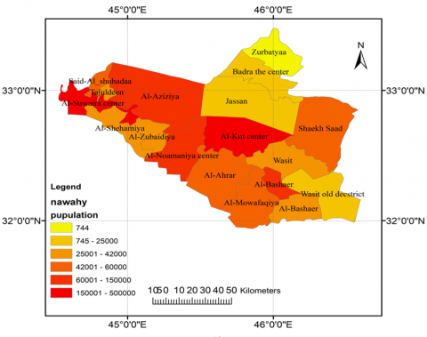
Iraq faces challenges due to structural discrepancies in its spatial economic framework, which have obstructed the implementation of development programs and their financial distributions, both spatially and sectorally [18]. To enhance the spatial distribution of investment allocations, these are aligned with the standards set forth in the provincial development plans and are consistent with the principles of administrative decentralization stipulated by the Constitution of the Republic of Iraq in 2005 [19]. Consequently, the responsibilities of sectoral ministries have evolved to include determining needs within the provinces and developing and executing plans and programs for infrastructure that significantly impact citizen welfare. Regional programs are designed to address economic, social, and environmental challenges [20], representing crucial administrative tools for delivering services across various sectors and achieving associated social and economic objectives [21, 22]. Initiated in 2006, this program allocates financial resources from the central government to the governorates based on population size and the relative significance of each governorate. These allocations are then distributed within the governorates to administrative units Figure 1.
Figure 1. Population distribution according to administrative units of Wasit Governorate for the year 2022 [23]
Investment allocations within the Regional Development Program are spatially distributed across administrative units in the form of projects targeting various service sectors. These sectors include networks and stations for sewage, municipal works, general infrastructure, health services, drinking water, as well as roads, electricity, and building projects. Despite over fifteen years of ongoing implementation, the developmental impact of the program remains unclear, prompting a reassessment of the executed plans. This review aims to analyze the reality of spatial development, highlight disparities [24] between administrative units, and propose a new mechanism for the spatial distribution of investment allocations to expedite the development process.
The study employed a descriptive analytical approach to examine the spatial development disparities within Wasit Governorate. This methodology was chosen due to its effectiveness in providing a comprehensive understanding of complex phenomena by describing and interpreting conditions as they exist. The research methodology involved several distinct stages:
Data Collection
Indicator Selection
The study utilized a set of spatial development indicators to assess and compare development levels across different administrative units. These indicators included:
Analytical Techniques
Framework Development
Based on the findings from the data analysis, a new framework for resource allocation was proposed. This framework was designed to address the specific needs of each administrative unit, taking into consideration both their population size and developmental requirements.
Validation and Testing
Quality Assurance Measures
To ensure the quality of the analysis, several measures were implemented:
This methodological framework provided a rigorous basis for analyzing the developmental impact of the Regional Development Program and proposing effective modifications to enhance its efficacy. The approach ensured that the findings were grounded in empirical evidence and relevant to the local context, thereby supporting the development of actionable and sustainable policy recommendations.
Development measures vary based on the objectives and characteristics of a given initiative, whether they are economic or social, qualitative or quantitative. There is no universally ideal method or indicator for measuring spatial development disparities. Owing to the variety of development measures and their significant conceptual and practical diversity [25], researchers are afforded the flexibility to select the methodology that best suits their study. The factor analysis scale developed by Berry is regarded as a critical standard for interpreting spatial relationships and identifying factors that contribute to regional strengths or weaknesses [26].
To elucidate development disparities, the following indicators will be utilized:
These indicators are categorized into social indicators (items 3, 4, 5, 6, and 7) and economic indicators (items 1, 2, 8, and 9). The subsequent table, Table 1 displays the status of these development indicators at the administrative unit level within Wasit Governorate.
The table presented above indicates that the administrative units of Sayyid al-Shuhada and Old Wasit have not had their development indicators measured by the planning teams in the relevant sectoral departments due to their recent establishment. Consequently, these units will be excluded from the process of measuring development indicators to prevent the generation of unrealistic data for these units.
Furthermore, the organization of the nine development indicators is clearly divided into two categories:
1. Indicators with Positive Effects: These include the first, second, eighth, and ninth indicators. Administrative units achieving the highest rates in these indicators are ranked first, whereas those with the lowest rates are ranked last.
2. Indicators with Negative Effects: Comprising the third, fourth, fifth, sixth, and seventh indicators, the ranking logic is inverted compared to the positive indicators. Here, the administrative unit with the highest rate is placed last, establishing a reversed hierarchy for these specific indicators.
The hierarchical structure of development indicators across the administrative units of Wasit Governorate is detailed in Table 2.
Table 1. Development indicators in administrative units [23]
|
|
Administrative Unit |
Labor Force (Age 15-64) |
Administrative Area (km²) |
Sewerage Services Gap |
Municipal Services Gap |
Education Gap (School Buildings) |
Health Sector Gap (Health Centers) |
Drinking Water Gap |
Percentage of Arable Land |
Relative Industrial Importance |
|
1 |
Kut |
262897 |
1761 |
32 |
21.44 |
39 |
52 |
87 |
20 |
45 |
|
2 |
Suwayra |
86150 |
427 |
15 |
64.44 |
54 |
25 |
51 |
98 |
8.2 |
|
3 |
Numaniyah |
67275 |
1144 |
27.5 |
90.29 |
44 |
50 |
68 |
34 |
6.4 |
|
4 |
Aziziyah |
60266 |
1431 |
50 |
44.15 |
48 |
36 |
0 |
95 |
7.3 |
|
5 |
Al-Hai |
57418 |
324 |
46 |
87.47 |
58 |
20 |
32 |
49 |
14 |
|
6 |
Zubaidiyah |
32508 |
226 |
51.5 |
- |
- |
- |
- |
- |
- |
|
7 |
Al-Ahrar |
32114 |
479 |
85 |
71.19 |
45 |
83 |
159 |
75 |
4.7 |
|
8 |
Al-Muwafaqiya |
32057 |
1226 |
72.5 |
43.26 |
33 |
16 |
91 |
57 |
2.5 |
|
9 |
Sheikh Saad |
30257 |
1124 |
75 |
62.96 |
23 |
66 |
271 |
51 |
1.4 |
|
10 |
Al-Bashair |
23117 |
1801 |
75 |
61.85 |
41 |
75 |
30 |
78 |
1.3 |
|
11 |
Al-Shehimiya |
21174 |
641 |
85 |
89.46 |
21 |
100 |
0 |
77 |
- |
|
12 |
Wasit Subdistrict |
21124 |
920 |
80 |
61.13 |
50 |
75 |
15 |
87 |
1.1 |
|
13 |
Taj al-Din |
19877 |
775 |
85 |
61.77 |
30 |
20 |
209 |
41 |
1.1 |
|
14 |
Al-Dabouni |
14103 |
120 |
79.5 |
53.72 |
56 |
87 |
479 |
83 |
2.8 |
|
15 |
Badra |
13668 |
742 |
80 |
24.8 |
36 |
50 |
30 |
52 |
1 |
|
16 |
Jassan |
9213 |
940 |
57.5 |
65.52 |
29 |
0 |
92 |
16 |
2.2 |
|
17 |
Zurbatiyah |
7845 |
1176 |
90 |
--- |
- |
- |
- |
- |
- |
|
18 |
Kut |
7126 |
1927 |
85 |
83.25 |
10 |
+66 |
494 |
97 |
1 |
|
19 |
Suwayra |
409 |
649 |
60 |
85.53 |
40 |
0 |
250 |
40 |
- |
Table 2. Ranking of development indicators in administrative units
|
|
Relative Industrial Importance |
Percentage of Arable Land |
Drinking Water Gap |
Health Sector Gap (Health Centers) |
Education Gap (School Buildings) |
Municipal Services Gap |
Sewerage Services Gap |
Administrative Area (km²) |
Labor Force (Age 15-64) |
Administrative Unit |
|
1 |
Kut |
1 |
3 |
3 |
1 |
8 |
8 |
7 |
16 |
1 |
|
2 |
Suwayra |
2 |
15 |
1 |
10 |
15 |
5 |
5 |
1 |
3 |
|
3 |
Numaniyah |
3 |
6 |
2 |
17 |
11 |
7 |
6 |
15 |
5 |
|
4 |
Aziziyah |
4 |
4 |
5 |
4 |
13 |
6 |
1 |
3 |
4 |
|
5 |
Al-Hai |
5 |
16 |
4 |
15 |
17 |
4 |
4 |
12 |
2 |
|
6 |
Zubaidiyah |
6 |
14 |
12 |
12 |
12 |
11 |
10 |
8 |
6 |
|
7 |
Al-Ahrar |
7 |
5 |
8 |
3 |
6 |
3 |
8 |
9 |
8 |
|
8 |
Al-Muwafaqiya |
8 |
7 |
9 |
9 |
3 |
9 |
13 |
11 |
10 |
|
9 |
Sheikh Saad |
9 |
2 |
9 |
8 |
10 |
10 |
3 |
6 |
11 |
|
10 |
Al-Bashair |
10 |
13 |
12 |
16 |
2 |
13 |
1 |
7 |
14 |
|
11 |
Al-Shehimiya |
11 |
9 |
11 |
6 |
14 |
10 |
2 |
4 |
12 |
|
12 |
Wasit Subdistrict |
12 |
10 |
12 |
7 |
5 |
4 |
11 |
13 |
12 |
|
13 |
Taj al-Din |
13 |
17 |
10 |
5 |
16 |
12 |
14 |
5 |
7 |
|
14 |
Al-Dabouni |
14 |
11 |
11 |
2 |
7 |
7 |
3 |
10 |
13 |
|
15 |
Badra |
15 |
8 |
6 |
11 |
4 |
2 |
9 |
17 |
9 |
|
16 |
Jassan |
16 |
1 |
12 |
13 |
1 |
1 |
15 |
2 |
13 |
|
17 |
Zurbatiyah |
17 |
12 |
7 |
14 |
9 |
2 |
12 |
14 |
14 |
The table presented above demonstrates that the rankings of the indicators used in analyzing each administrative unit within the governorate are not consistent. For instance, the city of Kut is ranked first in the labor force indicator, fourth in municipal services, ninth in relative industrial importance, and third in both the area and sewage services indicators. Similarly, Aziziya is ranked first in the water services indicator and thirteenth in the education sector indicator. This pattern varies across other administrative units as well, illustrating the diverse states of spatial development within each unit. This approach allows for a nuanced measurement of development across the governorate's administrative landscape.
7.1 Development degree scale
This metric is based on the hierarchical classification of regions (administrative units) according to the degree of development measured and the indicators used in the analysis [27]. Refer to the previously mentioned Table 2, which divides the administrative units into three distinct development categories based on the hierarchy established by each indicator:
By applying this classification and assigning a specific score to each administrative unit based on their performance in each indicator, we construct Table 3. This table details the scoring and categorization process, allowing for a clear comparison of development levels across the administrative units. The rank will be denoted by the symbol (R) and the degree of that rank by the symbol (S).
To determine the ranking of administrative units based on their degree of development, we multiply the rank (R) assigned to each indicator by the score (S) it achieves for each administrative unit. This calculation results in a developmental ranking for the units, where the unit ranking first is the one with the lowest composite score, indicative of higher development status. This ranking is detailed in Table 4.
The table above clearly categorizes the administrative units into three distinct development groups based on the degree of development scale. The units Al-Aziziyah, Al-Ahrar, Kut, Sheikh Saad, Suwayra, and Numaniyah (ranks 1-6) fall within the first development category, indicating the highest level of development. The units Al-Muwafaqiya, Al-Dabouni, Al-Shahimiya, Badra, and Hay (ranks 7-11) are placed in the second development category. Meanwhile, the units Jassan, Wasit district, Zubaidiyah, Bashaer, Taj al-Din, and Zurbatiyah (ranks 12-17) are classified within the third development category, reflecting the lower tiers of development as per the applied scale.
7.2 Development rank scale
The development rank scale is a metric used to assess spatial development among administrative units and represents the second proposed measure for evaluating development rankings. This scale is calculated by summing the products obtained from multiplying the frequency of each rank by its assigned point value across all indicators used in the analysis. This approach follows a tripartite rank classification as outlined in Table 2, where the first rank is valued at five points, the second rank at three points, and the third rank at one point. The formula for this calculation is R = P1n1 + P2n2 + P3*n3 [27], where 'R' represents the development rank score.
Table 3. The scores of development indicators according to administrative units
|
Relative Industrial Importance |
Percentage of Arable Land |
Drinking Water Gap |
Health Sector Gap (Health Centers) |
Education Gap (School Buildings) |
Municipal Services Gap |
Sewerage Services Gap |
Administrative Area (km²) |
Labor Force (Age 15-64) |
Administrative Unit |
|
|||||||||
|
S |
R |
S |
R |
S |
R |
S |
R |
S |
R |
S |
R |
S |
R |
S |
R |
S |
R |
|
|
|
1 |
1 |
3 |
1 |
3 |
1 |
1 |
1 |
8 |
2 |
8 |
2 |
7 |
2 |
16 |
3 |
1 |
1 |
Kut |
1 |
|
2 |
1 |
15 |
3 |
1 |
1 |
10 |
2 |
15 |
3 |
5 |
1 |
5 |
1 |
1 |
1 |
3 |
1 |
Suwayra |
2 |
|
3 |
1 |
6 |
1 |
2 |
1 |
17 |
3 |
11 |
2 |
7 |
2 |
6 |
1 |
15 |
3 |
5 |
1 |
Numaniyah |
3 |
|
4 |
1 |
4 |
1 |
5 |
1 |
4 |
1 |
13 |
3 |
6 |
1 |
1 |
1 |
3 |
1 |
4 |
1 |
Aziziyah |
4 |
|
5 |
1 |
16 |
3 |
4 |
1 |
15 |
3 |
17 |
3 |
4 |
1 |
4 |
1 |
12 |
3 |
2 |
1 |
Al-Hai |
5 |
|
6 |
1 |
14 |
3 |
12 |
3 |
12 |
3 |
12 |
3 |
11 |
2 |
10 |
2 |
8 |
2 |
6 |
1 |
Zubaidiyah |
6 |
|
7 |
2 |
5 |
1 |
8 |
2 |
3 |
1 |
6 |
1 |
3 |
1 |
8 |
2 |
9 |
2 |
8 |
2 |
Al-Ahrar |
7 |
|
8 |
2 |
7 |
2 |
9 |
2 |
9 |
2 |
3 |
1 |
9 |
2 |
13 |
3 |
11 |
2 |
10 |
2 |
Al-Muwafaqiya |
8 |
|
9 |
2 |
2 |
1 |
9 |
2 |
8 |
2 |
10 |
2 |
10 |
2 |
3 |
1 |
6 |
1 |
11 |
2 |
Sheikh Saad |
9 |
|
10 |
2 |
13 |
3 |
12 |
3 |
16 |
3 |
2 |
1 |
13 |
3 |
1 |
1 |
7 |
2 |
14 |
3 |
Al-Bashair |
10 |
|
11 |
2 |
9 |
2 |
11 |
2 |
6 |
1 |
14 |
3 |
10 |
2 |
2 |
1 |
4 |
1 |
12 |
3 |
Al-Shehimiya |
11 |
|
12 |
3 |
10 |
2 |
12 |
3 |
7 |
2 |
5 |
1 |
4 |
1 |
11 |
2 |
13 |
3 |
12 |
3 |
Wasit Subdistrict |
12 |
|
13 |
3 |
17 |
3 |
10 |
2 |
5 |
1 |
16 |
3 |
12 |
3 |
14 |
3 |
5 |
1 |
7 |
2 |
Taj al-Din |
13 |
|
14 |
3 |
11 |
2 |
11 |
2 |
2 |
1 |
7 |
2 |
7 |
2 |
3 |
1 |
10 |
2 |
13 |
3 |
Al-Dabouni |
14 |
|
15 |
3 |
8 |
2 |
6 |
1 |
11 |
2 |
4 |
1 |
2 |
1 |
9 |
2 |
17 |
3 |
9 |
2 |
Badra |
15 |
|
16 |
3 |
1 |
1 |
12 |
3 |
13 |
3 |
1 |
1 |
1 |
1 |
15 |
3 |
2 |
1 |
13 |
3 |
Jassan |
16 |
|
17 |
3 |
12 |
3 |
7 |
2 |
14 |
3 |
9 |
2 |
2 |
1 |
12 |
3 |
14 |
3 |
14 |
3 |
Zurbatiyah |
17 |
Table 4. Ranking of administrative units according to the degree of development scale
|
No. |
Administrative Unit |
Development Score |
|
1 |
Aziziyah District |
70 |
|
2 |
Al-Ahrar District |
97 |
|
3 |
Kut District |
103 |
|
4 |
Sheikh Saad Sub-district |
125 |
|
5 |
Suwayra District |
127 |
|
6 |
Numaniyah District |
154 |
|
7 |
Al-Muwafaqiya District |
168 |
|
8 |
Al-Dabouni Sub-district |
168 |
|
9 |
Al-Shehimiya Sub-district |
172 |
|
10 |
Badra District |
182 |
|
11 |
Al-Hai District |
199 |
|
12 |
Jassan Sub-district |
212 |
|
13 |
Wasit Sub-district |
212 |
|
14 |
Zubaidiyah District |
220 |
|
15 |
Bashaer Sub-district |
241 |
|
16 |
Taj al-Din Sub-district |
260 |
|
17 |
Zarbatiyah Sub-district |
283 |
'n' represents the points associated with each rank level.
By applying these calculations and comparing the results, the development ranks of the administrative units are derived and displayed in Table 5. It is observed that despite variations within the ranking sequences, the administrative units retain their respective development scores, as illustrated in the accompanying Figure 2.
Table 5. Ranking of administrative units according to the development rank scale
|
No. |
Administrative Unit |
Development Rank |
|
1 |
Aziziyah District |
41 |
|
2 |
Al-Ahrar District |
35 |
|
3 |
Kut District |
35 |
|
4 |
Suwayra District |
35 |
|
5 |
Sheikh Saad Subdistrict |
33 |
|
6 |
Numaniyah District |
33 |
|
7 |
Al-Hai District |
29 |
|
8 |
Al-Shehimiya Subdistrict |
29 |
|
9 |
Badra District |
29 |
|
10 |
Al-Mowafaqiya District |
27 |
|
11 |
Al-Dabouni Subdistrict |
27 |
|
12 |
Jassan Subdistrict |
25 |
|
13 |
Zubaidiyah District |
23 |
|
14 |
Wasit Subdistrict |
23 |
|
15 |
Taj al-Din Subdistrict |
21 |
|
16 |
Al-Bashair Subdistrict |
21 |
|
17 |
Zarbatiya Subdistrict |
17 |
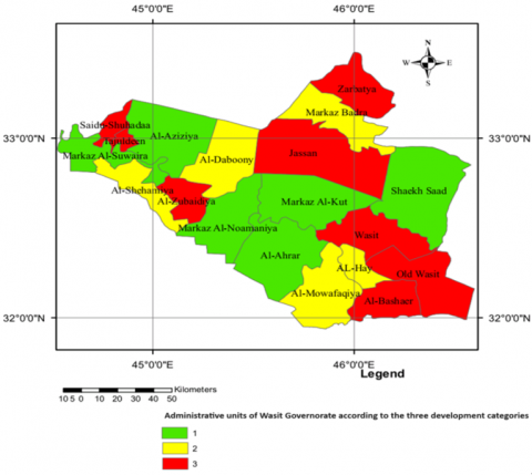
As indicated in the data presented above, the administrative units of Wasit Governorate have consistently maintained their respective classifications within the three predefined development categories, as established by the previous two standards. This consistency is further illustrated in Figure 2. However, it is evident that there are significant variations in development levels among these units. These discrepancies underscore the necessity for implementing new and more effective mechanisms to address these differences. The primary objective of establishing the investment budget is to facilitate comprehensive development across various dimensions by strategically allocating financial resources among the governorates. This strategic distribution aims to mitigate development disparities and promote balanced regional growth.
Figure 2. Administrative units of Wasit Governorate according to the three development categories
The research conducted on the spatial development in Wasit Governorate provides in-depth insights into the effectiveness of the current Regional Development Program and its impact on the administrative units. This section summarizes the key findings derived from the comprehensive analysis of development indicators and resource allocation mechanisms. By closely examining the disparities and inefficiencies in the current system, the study lays the groundwork for proposing a more nuanced and equitable approach to development planning. The findings are structured into major themes as outlined below, each highlighting critical aspects of the developmental dynamics within the governorate.
8.1 Key findings
These findings underscore the need for a strategic overhaul of the developmental policies and allocation practices currently in place, aiming to achieve a more equitable and effective distribution of resources that caters to the nuanced needs of Wasit Governorate's diverse administrative landscape.
The findings of this study reveal significant spatial development disparities within Wasit Governorate, aligning with and diverging from existing research in various ways. This section compares the study’s results with previous local and international research, discussing consistencies, discrepancies, and exploring the possible reasons for these differences.
Comparison with Local Research:
Comparison with International Research:
Consistencies:
Discrepancies:
Exploring the Reasons for Discrepancies:
This study offers critical insights into the spatial development dynamics within Wasit Governorate, underpinned by a detailed analysis of development indicators and resource allocation mechanisms. Key conclusions drawn from the research emphasize the necessity for revising current strategies to enhance developmental equity and efficiency:
These conclusions aim to contribute to the broader discourse on regional development, providing a foundation for policymakers to refine strategies that will lead to more balanced growth and reduced disparities across the Wasit Governorate. The study's recommendations, if implemented, are expected to foster a more equitable distribution of resources, catalyzing sustainable development and enhancing the quality of life for residents across the region.
Based on the findings of this study on spatial development in Wasit Governorate, several strategic recommendations are proposed to enhance the effectiveness of regional development initiatives. These recommendations are designed to address the identified disparities and improve the overall developmental impact within the governorate:
These recommendations are aimed at refining development policies and practices within Wasit Governorate to achieve a more balanced and inclusive growth. By implementing these strategies, it is anticipated that the governorate will witness significant improvements in its developmental outcomes, contributing to the overall socio-economic stability and prosperity of the region.
[1] Mnatsakanyan, T., Hayrapetyan, R., Molnar, D. (2021). Measuring regional development disparities: Some methodological contributions and evidence from Armenia and Serbia. Regional Science Inquiry, 13(2): 327-348.
[2] Mashiri, M., Njenga, P., Njenga, C., Chakwizira, J., Friedrich, M. (2017). Towards a framework for measuring spatial planning outcomes in South Africa. Sociology and Anthropology, 5(2): 146-168. https://doi.org/10.13189/sa.2017.050205
[3] Jasim, I.A., Hasan, H.M., Farhan, S.L., Bahat, K.H. (2021). Evaluating the urban structure of Al-Kut city according to sustainability. In IOP Conference Series: Earth and Environmental Science, Turkey, p. 012021. https://doi.org/10.1088/1755-1315/779/1/012021
[4] Altaie, K.H., Laftah, S.F., Muhammed, H.J. (2022). Does reform plan really works? Assessing entity development plan in wasit province-Iraq. World Economics and Finance Bulletin, 8: 46-53.
[5] Pratibha, B., Rakesh, J., Radhika, M., Shivaji, P. (2023). A proposed integrated development plan using modified planning standards for a small urban town: A case study of mohol town, Dist. Solapur, India. Civil Engineering Architecture, 11(2): 586-601. https://doi.org/10.13189/cea.2023.110205
[6] Achten, S., Lessmann, C. (2020). Spatial inequality, geography and economic activity. World Development, 136: 105114. https://doi.org/10.1016/j.worlddev.2020.105114
[7] van Niekerk, A.J. (2020). Inclusive economic sustainability: SDGs and global inequality. Sustainability, 12(13): 5427. https://doi.org/10.3390/su12135427
[8] Efimova, E., Prostova, D., Lukashenok, T. (2023). Modelling sustainable spatial development of Russian regions. In E3S Web of Conferences, Novosibirsk, Russia, p. 02007. https://doi.org/10.1051/e3sconf/202345102007
[9] Zohra, B.F., Foued, B. (2023). The role of urban development strategy in achieving a strategic urban planning in new cities-case: The new city''ali mendjeli'' (Algeria). Architecture, 11(5): 2840-2855. https://doi.org/10.13189/cea.2023.110543
[10] Tolba, M.E., El Kaleq Ibrahim, A., Mohamed, T.W. (2023). Developing a methodological model for monitoring and measuring urban poverty and deprivation, and its spatial distributions. International Journal of Sustainable Development & Planning, 18(10): 2989-3004. https://doi.org/10.18280/ijsdp.181002
[11] Green, A.E. (2011). Spatial inequality and skills in a changing economy. UKCES.
[12] Iammarino, S., Rodríguez-Pose, A., Storper, M. (2017). Why regional development matters for Europe’s economic future. European Commission Directorate General for Regional and Urban Policy Working Paper, 7: 2017.
[13] Abd, M.K. (2020). Indicators of urban development in Al-Majar Al-kabeer town. The Arab Gulf, 48(4): 797-818.
[14] Bunge, M. (1981). Development indicators. Social Indicators Research, 9: 369-385. https://doi.org/10.1007/BF00300662
[15] Ebraheem, M.A., Ebraheem, A.K., Hasan, S.A., Faleeh, M.K. (2021). The importance of spatial indicators to producing development plans. Journal of the Planner and Development, 26(1): 1-30.
[16] Modai-Snir, T., Plaut, P. (2019). The analysis of residential sorting trends: Measuring disparities in socio-spatial mobility. Urban Studies, 56(2): 288-300. https://doi.org/10.1177/0042098018798759
[17] Khalil, S.M., Ebrahim, M.A. (2020). The place attachment value, measurement of place potentials. In IOP Conference Series: Materials Science and Engineering, Turkey, p. 012179. https://doi.org/10.1088/1757-899X/737/1/012179
[18] Al_Shadidi, H.A.S. (2021). Impact of structural imbalances on the sustainability of spatial development programs. In IOP Conference Series: Earth and Environmental Science, Iraq, p. 012012. https://doi.org/10.1088/1755-1315/754/1/012012
[19] Farhan, S.L., Mutaz, T., Altaie, K., Zubaidi, S.L. (2023). Measuring equity in spatial development investments for the provincial development program in Wasit governorate. In IOP Conference Series: Earth and Environmental Science, IOP Publishing, p. 012035. https://doi.org/10.1088/1755-1315/1129/1/012035
[20] Tsypkin, Y.A., Fomin, A.A., Kamaev, R.A., Kozlova, N.V., Gubarev, E.V. (2020). Strategic digital model for sustainable spatial regional development. In IOP Conference Series: Earth and Environmental Science, Russian Federation, p. 012138. https://doi.org/10.1088/1755-1315/579/1/012138
[21] Sabae Al-Qaisi, N., Faris, A.A. (2023). Options for implementing regional development projects: A comparative analytical study in the holy city of Karbala. Tikrit Journal of Administration and Economics Sciences, 19(63): 166-183. https://doi.org/10.25130/tjaes.19.63.2.9
[22] Fedchenko, E.A., Gusarova, L.V., Lysenko, A.A., Vankovich, I.M., Chaykovskaya, L.A., Savina, N.V. (2023). Audit of national projects as a factor in achieving sustainable development goals. International Journal of Sustainable Development & Planning, 18(5): 1319-1328. https://doi.org/10.18280/ijsdp.180502
[23] Shkvarya, L. (2022). Iraq in the regional economy and social sphere and the problems of reconstruction. Asia and Africa Today, 8: 34-41. https://doi.org/10.31857/s032150750021325-9
[24] Kashkari, M., Brar, T.S. (2023). Planning for sustainable urban developments: The historic towns of Karnataka, India. ISVS e-Journal, 10(1): 217-228.
[25] Wong, C., Arnold, T., Baker, M., Koksal, C., Schulze Bäing, A., Wei Zheng, H. (2019). Measuring spatial inequality in the UK: What we know and what we should know? The Spatial Policy & Analysis Laboratory, Manchester Urban Institute, University of Manchester, UK, 2070.
[26] Saad Al-Shedidi, H.A. (2012). Spatial Development Disparities in Iraq by the proposed development measuring and ways of facing it. Journal of the Planner and Development, 17(2): 216-238.
[27] Abdulaal, A. (1997). Proposed quantitative measures for some geographical phenomena. 1st ed. no. 9. Geographic and development Journal.