Helbin Yaseen Younis*![]() | Raed Salim Ahmed
| Raed Salim Ahmed![]()
© 2024 The authors. This article is published by IIETA and is licensed under the CC BY 4.0 license (http://creativecommons.org/licenses/by/4.0/).
OPEN ACCESS
Different types of dwellings are shaped by the interaction between human needs and the surrounding environment, creating a wide range of complex structures reflecting different lifestyles and environmental conditions. this research aimed to explore different spatial configurations in traditional mountain dwellings, especially in the case of the old city of Akre using 3D space syntax methodology to analyze the planning scheme of 15 dwellings. The emphasis is to trace out the underlying structures, describe the spatial configurations, and bring to sight the functions and interrelations of living spaces. A lens that captures the essence of these places is the one that the research uses to probe how the topography highly impacts their floor plan and arrangement, such that many dwellings have various entrance levels as an adaptive measure to the city’s topography. Ultimately, the study explores three types of planning schemes within these mountain dwellings: shallow, tree, and ring. However, the ring configuration, being the most common, serves as a testament to the topographical challenges faced by the old city of Akre. This research highlights the relationship between architectural design and natural landscapes, improving our understanding of spatial dynamics in traditional mountain dwellings. It sheds light on the architectural heritage diversity of the old city and its adaptability.
spatial configuration, traditional dwellings, architecture engineering, Old Akre City, mountain cities
Traditional dwellings constitute an essential aspect of people's cultural heritage [1]. They represent the typical character of societies, respond to material requirements, and are full of social, cultural, and heritage civilizations [2]. Nevertheless, traditional dwellings reflect human civilization's cultural identity, heritage, and architectural creativity. Therefore, housing adapts to the needs of residents, reflecting cultural lifestyles and the requirements of different geographical and environmental locations [3].
The geographical characteristics of sites often play an essential role in shaping the design of traditional dwellings, affecting their architectural styles. Thus, rather than changing the natural form of the land, residents often create design solutions that blend with the terrain, influencing the resulting architectural styles [4]. Additionally, the traditional dwellings developed by incorporating appropriate climatic, geographic, and cultural factors were not only the result of crafting skills but also the symbols of the wealth of knowledge acquired through centuries of experience and use of materials, the construction method, and the climate adaptive design [5, 6].
Many studies have addressed the role of site topography and its relationship to the spatial system of buildings, but they have not focused on an in-depth exploration of the role of site characteristics, including topography, on the spatial configuration of traditional housing. On the one hand, when it comes to the difficult mountainous landscape and architecture, it is necessary to point out the specificity of the architectural solutions of the traditional dwellings of the old city of Akre, which included a unified unit that integrated nature into the architectural design and followed the natural topography of the environment. This aspect has not been addressed in an architectural study. It aims to analyze the spatial system of these dwellings and explore their deep structure. Thus, the research problem was crystallized in the absence of a clear concept of the role of site characteristics in shaping the spatial organization of traditional buildings in the old city of Akre. Therefore, the current research aims to study the spatial configuration of various traditional dwellings in Akre to explore the role of site characteristics in general and topography in particular in the spatial configuration of traditional dwellings. To achieve this, the research used the three-dimensional spatial structure analysis technique, which provides a great ability to analyze the traditional dwelling's spatial system and explore the system's deep structure through integration, connectivity, and spatial depth with Various model designs. Therefore, the study adopted an innovative method to identify the complex relationship between topography and the spatial formation of traditional dwellings, which contributed to understanding the impact and role of topography in shaping the spatial and architectural configuration within the context of the cultural heritage of the Old Akre City.
Many studies have shown that the traditional architecture and urban fabric of human settlements worldwide are influenced by various factors, including socioeconomic conditions, cultural background, climatic factors, and historical events [7]. On the other hand, despite adapting traditional dwellings to a strict climatic region, the environmental conditions that reflect climatic diversity greatly impact the spatial configuration of traditional dwellings. Indigenous dwellings have the natural advantage of resiliently adapting to the harsh weather conditions prevailing in the area, resulting in many spatial configurations, including attachments that holistically suit the local climate conditions [8]. In addition, the architectural style of traditional dwellings is impacted by cultural, social, and philosophical factors. Of course, the room's composition reflects cultural beliefs that support conventional living arrangements characteristic of a specific family type. This is demonstrated by the courtyard’s and rooms’ original designs focused on safety and privacy. while also evolving to accommodate environmental and social needs [9]. Research has also shown that privacy, gender segregation, and hospitality are sociocultural factors that affect how spaces are set up. For example, living areas for men and women are separate, and guest rooms are carefully designed to reflect how important hospitality is in some cultures. These factors, together, shape the architectural identity and evolution of traditional dwellings [2]. Topographical features, climate conditions, and the sun's orientation are crucial factors that affect traditional dwellings' spatial configuration and structural elements in mountainous regions, as noted in references [10-12]. The rugged terrain requires multi-level structures that follow the natural contours of hills, minimizing land disruption and increasing stability. This tiered architecture allows for different levels of exposure to sunlight and wind, optimizing conditions for passive solar heating and natural cooling. Therefore, storage or less actively utilized areas are positioned on the cooler side to retain lower temperatures throughout the day, whereas the living areas are oriented towards the sunnier side.
In addition, the slope may dictate the placement of doors in the dwelling and the spacing of the interior spaces to ensure optimum lighting and ventilation, improving comfort and efficiency in energy use. This decision-making style highlights the fact that the dwellings have been put in an environment in such a way that they blend with the surroundings, promoting sustainability and improving residents' lives. The configuration of buildings within a given area is significantly influenced by its topography, particularly in regions characterized by varied elevations, such as mountainous or hilly terrain. The nature of the mountainside completely controls the general architecture of the dwellings. The habitations are designed to consider natural geographical features; hence, interior spaces are differentiated by levels. The buildings are to be built according to the land, making the dwellings appear as single-story structures from one side while transforming into multi-story structures from the other. This building technique is in compliance, and the perfect blend of the housing units with their surrounding environment is achieved. Additionally, this design methodology guarantees the harmonious integration of the dwellings with their environment and leverages the natural terrain to enhance the practicality and ease of access within the dwellings [4].
The orientation and room arrangement are made according to the topography so that natural light gets utilized the most and that exposure to natural dangerous factors, like wind and rain, gets reduced. Nevertheless, the number of members in the family, social norms, cultural influences, and the availability of construction materials all affect the residence design. The traditional ways in which indigenous people design interiors are influenced by many factors, which result in both functional and culturally suitable for the occupants [13, 14]. Adjusting to environmental conditions involves such aspects as material selection and architectural features such as placement of windows and wall thickness. They are determined by the climatic [14] (Figure 1).
Figure 1. Factors that affect the spatial configuration of traditional dwellings according to previous studies
In summary, the spatial configuration of traditional dwellings is often impacted by environmental factors, social backgrounds, and cultural influences, for example, as demonstrated in research studies. Research is severely lacking in the application of space syntax analysis to ascertain the manner in which topography impacts these configurations, specifically in mountainous regions. This informs the fact that the research has to be targeted to be able to use three-dimensional space syntax and analyze topography as a spatial factor that affects traditional dwellings’ configuration. So, the objective is to fill this knowledge gap and enhance our understanding of how topographical variations impact the functionality and accessibility of these dwellings.
3.1 Spatial configuration theory in architecture
Spatial configuration theory, primarily developed by Hillier and Hanson [15], and their colleagues, focuses on analyzing spatial relationships and patterns within architectural designs, laying the groundwork for constructing spatial syntax - a set of analytical tools aimed at understanding and measuring buildings and urban environments. This theory assumes that the arrangement and connectivity of spaces significantly influence individuals' use and perception of them. Space syntax is formulated on a theory that employs graphical and mathematical models that can be used for examining spatial configurations, focusing on integration to be able to ascertain how connected space is within a network, and connectivity to discover the number of direct connections in space. By using this model, we can improve the understanding of different space and behavior contexts as well as their role in both the architectural and urban design decision process, allowing us to drive important findings regarding spatial patterns. For instance, different activities – living, socializing, and interacting occur in different areas. This theory thus points out how the layout of the areas eventually erected corresponds to our civilization. The analysis of space composition rules reveals that any space's organization stems from two structural properties: symmetry and asymmetry, and diffusion and non-diffusion.
The former relates to the kinetic and visual depth among spaces within a system, with smaller spaces displaying increased symmetry and depth. The latter pertains to the availability of routes within the system to access its spaces, where a greater number of paths to a space enhances its diffusion in the system. This methodology allows for the explanation of space organization characteristics and the analysis and comparison of different space systems to identify their unique formulation differences. Understanding spatial configuration is thus essential for grasping the relationships between spaces in architecture, highlighting its significance in recognizing and comprehending architectural spaces' interconnectedness [15].
3.2 Interaction between topography and spatial configuration in dwellings
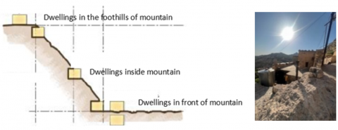
Topography is one of several elements that have an immediate effect on buildings. By impacting the interaction and combination of different elements within a space, it significantly contributes to the form of architecture. Nevertheless, in hilly areas, where strategic placement is a limiting factor for the dwelling's long-term survival, the selection of human dwelling places is an essential part of the planning process [16]. Different shaped and situated dwellings in mountainous regions fall into one of three categories: inside the mountains, at the foothills of mountains, or in front of mountains (Figure 2).
A B
Figure 2. A. Concept of mountainous dwellings [17]; B. Dwelling inside the mountain
Source: Authors
In areas with sloping terrain, dwellings are often constructed in a stacked manner, with upper-level patios situated above lower-level dwellings. Ground floors typically house storage areas and serve as pathways, while stairs provide access from the ground to the first floor. A unique architectural approach is employed when constructing cities on steep hills, organizing dwellings into distinct tiers. The roofs of the uppermost tier dwelling serve as their yards, and rooftops and courtyards function as pedestrian zones, resembling streets. Essentially, pedestrians navigate the rooftops of adjacent dwellings when crossing a thoroughfare [4].
3.3 3D space syntax: DepthSpace3D
Space syntax is a continuously developing set of methods based on underlying theoretical ideas. It is a well-known instrument in architecture and urban design studies. However, space is actually perceived in three dimensions, even though space syntax mainly analyzes 2D space. Thus, the third dimension must be added to fully understand space and its visibility in urban, architectural, and green spaces. However, before the release of DepthSpace3D, there was no open-use software for three-dimensional space syntax analysis that fully integrated concepts developed in space syntax theory [18]. DepthSpace3D is a digital tool designed for 3D space syntax analysis, available exclusively for Windows computers. Unlike 2D software applications like DepthMapX, DepthSpace3D can also analyze 3D spatial configuration, visibility, and accessibility. Compared to 2D analysis, 3D analysis can yield better results when analyzing the rough topography of urban spaces, dynamic volumetric geometry, and joint analysis of the interior of each building and its urban environment, particularly in the case of high-rise buildings. The analyzed space syntax functions and quantities can be viewed numerically and graphically, and animated graphics in the form of run-time movies can also be produced [19]. While space syntax 2D can deal fairly well with the interior of each home and the middle-scale urban environment, it falls short in integrating high-rise buildings as a whole in the context of the relationship between the building and its near environment as a unique analysis domain. At least 3D tools may demonstrate great usefulness in cases of rough topography of urban spaces, dynamic volumetric geometry, and joint analysis of the interior of each building and its urban environment, especially when there are high-rise buildings [20].
3.4 Syntactic variables
In space syntax, looking at the features of space through topological analysis can lead to the creation of morphological analysis variables [21]. The connectivity property is considered one of the clearest positional structural properties, as the connectivity of a space is measured by the sum of the number of spaces that are connected to it or intersect with it, that is, one step away from it, and thus it represents the degree of available choice. For movement from space to its neighbors. The integration property is considered one of the most important comprehensive properties, as it represents a measure of the extent of relative asymmetry within the space system, as relative asymmetry is achieved through the depth of the system’s relationships with other spaces. What concerns us in this research is measuring the structural characteristics of the interior spaces of the dwellings. Measuring these characteristics in any building represents a way to express the structure of its space relationships, which is known as Gama analysis, as the characteristics of space organization are known through two basic determinants. The first is the boundaries of the building, considering the entrance to the building as its basic space, and the second is a continuous internal space in which each space penetrates the other spaces [22].
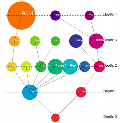
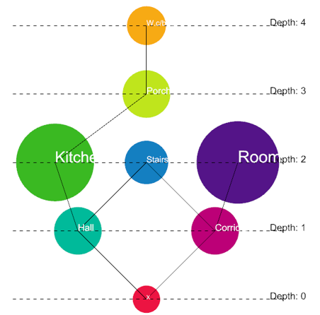
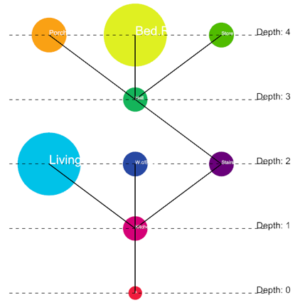
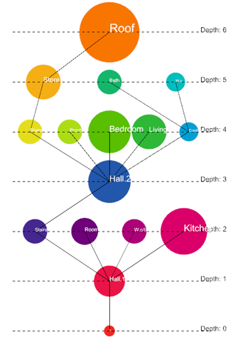
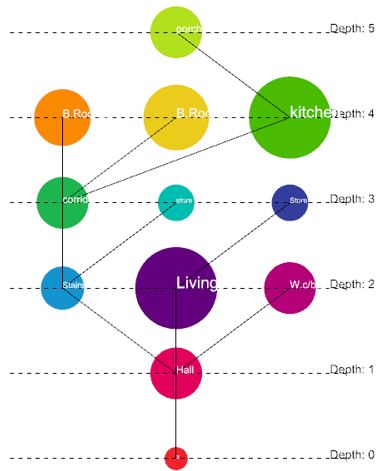
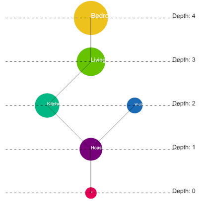
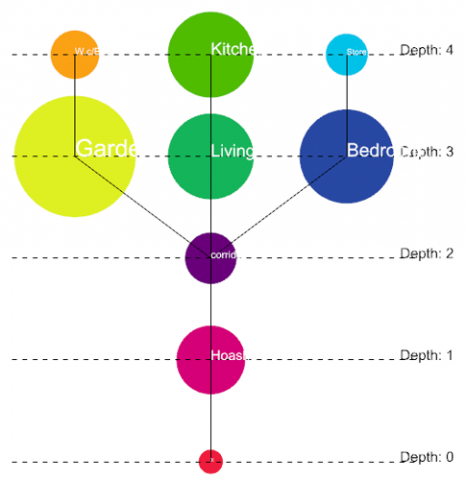
Representing the depth of system spaces depends mainly on constructing the alignment diagram (justified graph), through which all the building spaces are arranged at different depth levels and according to the number of spaces that must be passed through to reach all the system spaces from the base space. A space with a depth value of 1 means that the space is directly related to the basic space. A space that has a depth value of 2 means that there is an intermediate space between it and the basic space. As for the space whose depth value is 3, there are two intermediate spaces between this space and the basic space, and so on [23].
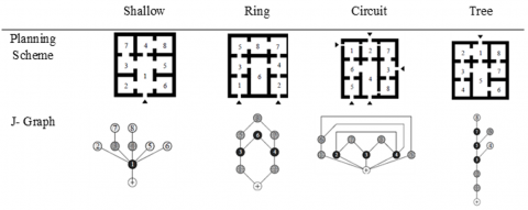
To know the depth of the space according to the space syntax methodology, a justified graph (J-graph) is built, and then the spaces are numbered, where the base space is given a number or its depth level is determined as zero. Then, the numbering of the spaces continues above the base space, and their depth is determined according to the aforementioned approach. However, different planning schemes called for different kinds of J-graphs, which may be either deep or shallow. The spatial linkages may also be looping rings or branching trees, circuit-like structures, or a shallow schematic plan (see Figure 3) [24].
Figure 3. J-graph describing the spatial configuration of four formally comparable floor layouts
Source: [24].
4.1 Case study
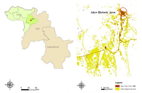
Akre City is located in the Dohuk Governorate in northern Iraq. Akre was part of the Nineveh province before 1991 but became formally included in the Kurdistan region after the 1991 revolt [25]. Akre City is an ancient city. The major core of Akre district is one of the six districts of Duhok Governorate (Figure 4). The city's historic district is designated as a cultural heritage site in Iraq's national inventory, the Atlas of Archaeological Sites in Iraq, published by the Ministry of Culture and Information of the Republic of Iraq, specifically by the Directorate General of Antiquities in 1970 [26].
A B
Figure 4. A. Akre City in the context of the Kurdistan region of Iraq. B. Akre historic area within Akre City
Source: [26]
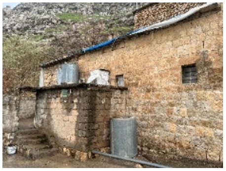
The historical area of Akre is located within mountains and situated on the southern slopes of a historical castle. It has a linear layout of dwellings. Known as terrace dwellings, these buildings are constructed to align with the natural slope of the land, enabling residents to use adjacent roofs for various activities. The terrace buildings are connected by an intricate network of small, winding, and steep walkways that reflect the difficult landscape of the region. These dwellings are built using natural materials including stone, lime, and wood. They usually have one or two floors, with their height determined by the steepness of the slope. These residences have unique brick cladding on the outside and a cave-like look on the inside. Akre's old residences are characterized by a unique network of winding staircases that are crucial for the inhabitants' everyday movement [27].
4.2 Research techniques and processes
This study utilizes a 3D space syntax-based methodology to explore the types of spatial configurations in Akre's old city. The analysis process in this study contains three stages:
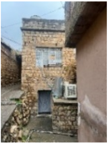
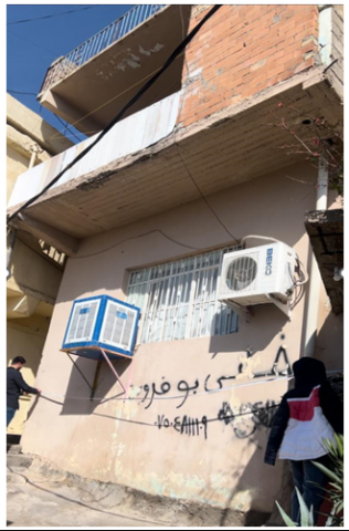
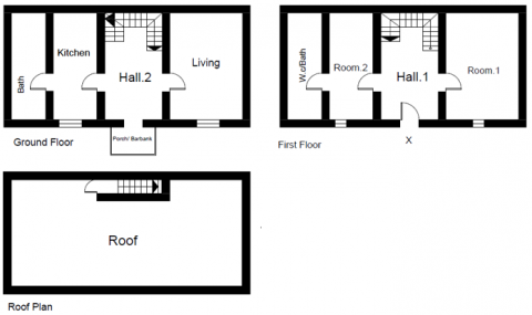
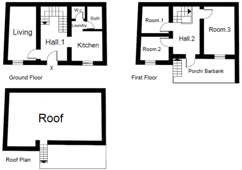
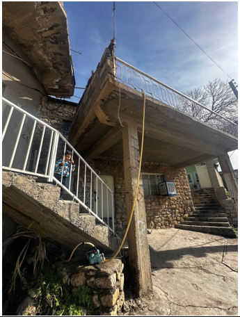
First stage: We select 15 samples from Old Akre City (Figure 5) based on specific criteria such as traditional features of these dwellings, interior preservation, and unique architectural characteristics like two doors or two floors. By focusing on dwellings that are notably affected by the area's topography.
Second stage: Our methodology involves on-site observations, documentation of these samples on the site by ourselves, and photography to gather qualitative and quantitative data, with the selected samples being digitally drafted in AutoCAD.
Figure 5. Old Akre City with selecting samples
Source: [27] developed by author
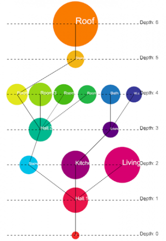
Figure 6. Clarification of the analysis process in Depth Space 3D
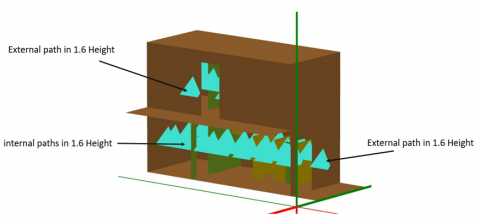
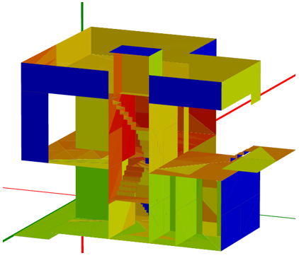
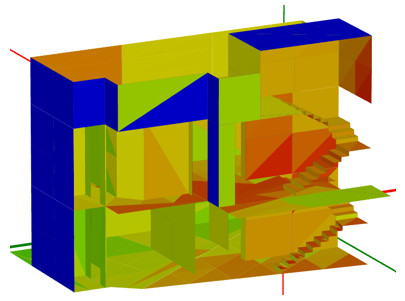
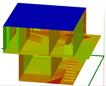
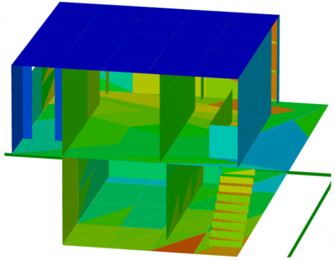
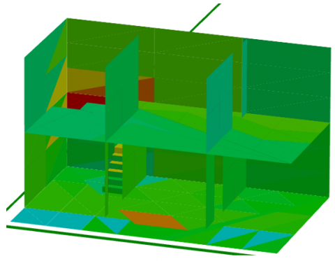
Third Stage: First, AutoCAD files are transferred to Rhinoceros Grasshopper to analyze the depth, and second, rhino files are transferred to DepthSpace3D to examine spatial parameters (integration and connectivity) and generate graphs and statistics. A two-stage approach simulates current designs to explore spatial configurations and then compares them to identify the dwelling types most influenced by topography. Why Depth Space 3D? DepthSpace3D is an advanced 3D space syntax analysis program that expands the capabilities of 3D analysis, providing benefits compared to traditional 2D approaches. As well as we used this programme because we investigated some samples with two entrances at different levels that are influenced by topographical features, and we placed the paths at a height of 1.6 meters to accommodate human movement, placing outside paths in both entrances (Figure 6). And this programme evaluates the integration value, connectivity, and many others parameters. For this reason, we have chosen to use DepthSpace3D for our investigation. Why 3D space syntax? Deploys the Grasshopper plug-in on Rhinoceros. Nourian's algorithm calculates output from several inputs. This approach evaluates integration, choice, control value, and entropy and gives a justified graph allowing for a comprehensive examination of buildings within their urban context. Ultimately, this research aims to classify traditional Akre dwellings and reveal how topography influences the spatial configuration of Old Akre City dwellings.
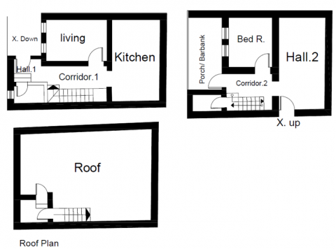
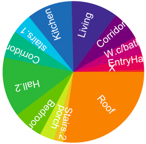
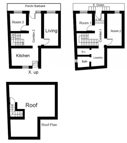
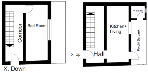
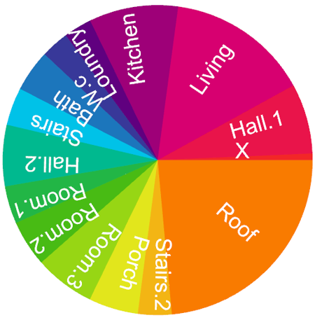
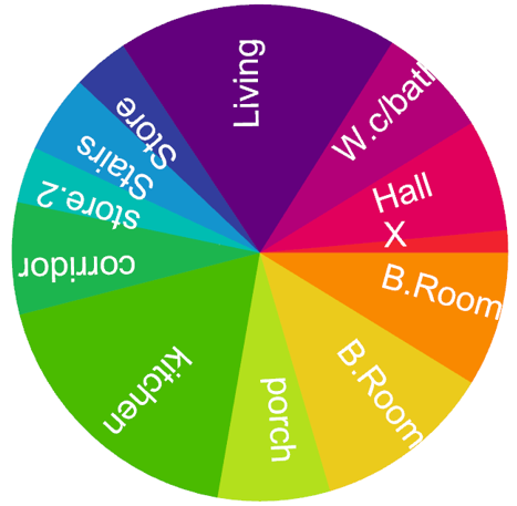
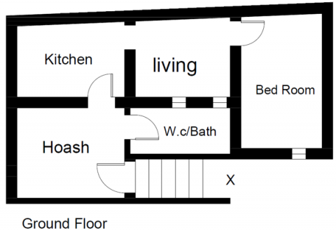
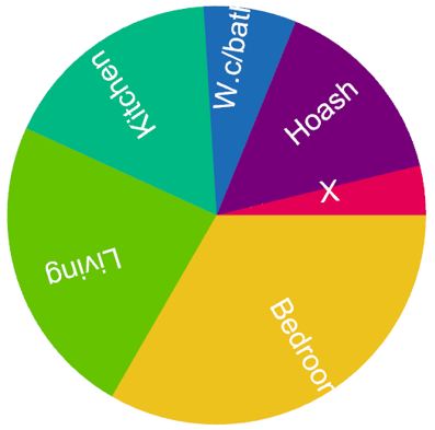
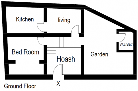
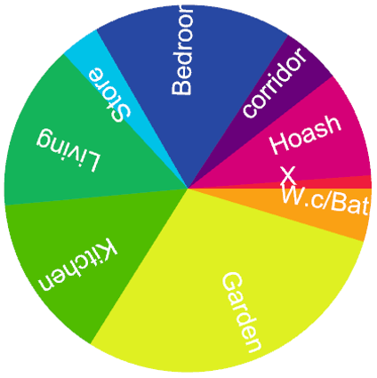
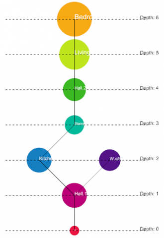
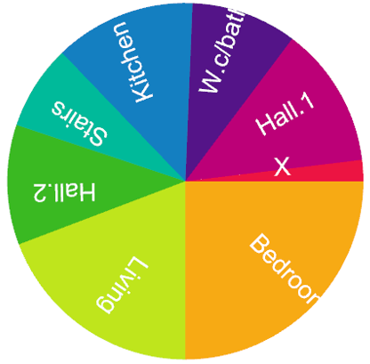
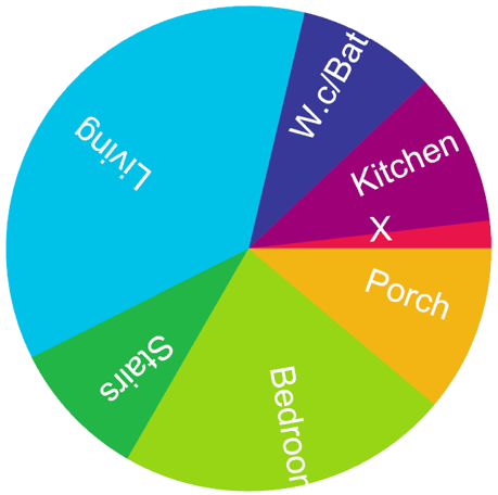
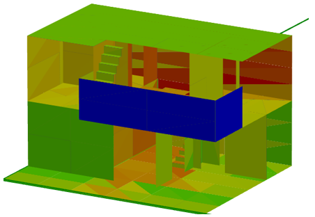
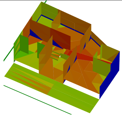
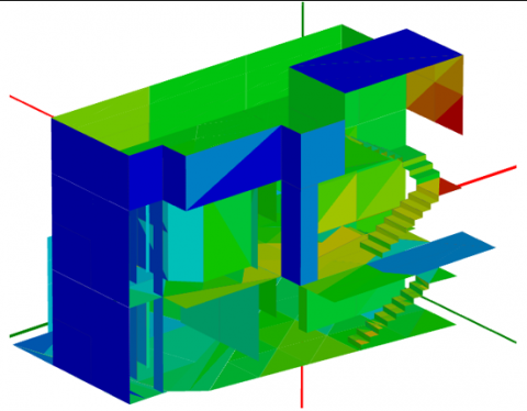
Table 1. Shows the J-graph analysis in 5 traditional dwellings (with two entrances) x is outside from both levels (Ring type)
|
Depth of Ring Planning Scheme |
|||
|
Photo |
Plan |
J-Graph |
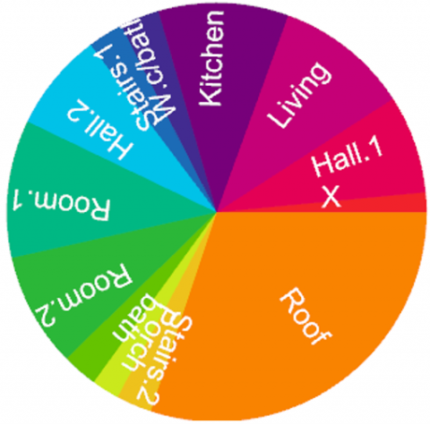
Pie Chart |
|
1. |
|||
|
2. |
|||
|
3. |
|||
|
4. |
|||
|
5. |
|||
According to the research results, Akre's old city displays three primary architectural patterns: the annular (ring) pattern, the shallow pattern, and the tree pattern.
5.1 Depth value
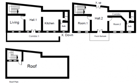
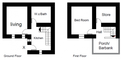
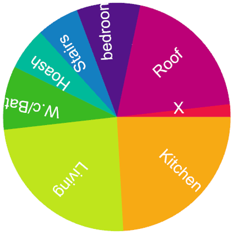
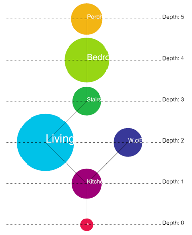
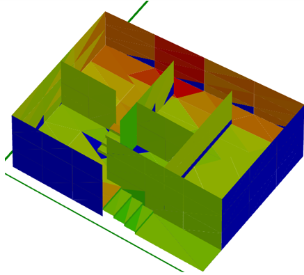
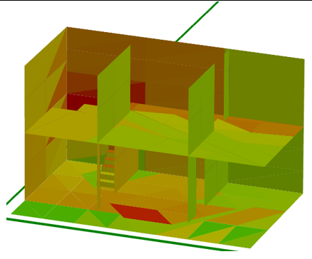
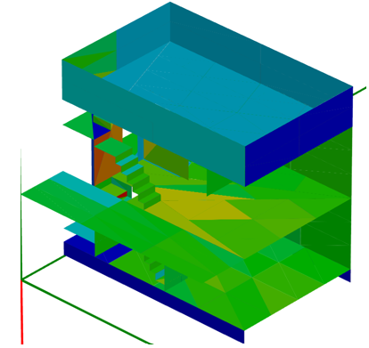
Depth value in dwellings was analyzed by 3D space syntax in Grasshopper. Ring pattern dwellings are characterized by two separate entrances at different levels. However, the higher depth remains at 4, with the porch and roof at higher depth while the hall and stairs are lower (see Table 1). However, shallow pattern dwelling configurations have only one entrance. However, the interior space has varying depths. The bedrooms, roof, and porch are at a higher level, between 5 and 6, while the living room and kitchen are at a medium depth 3 and 4. On the other hand, the entry hall is at a lower depth 1 (see Table 2). Table 3 shows that the tree pattern has a linear plan with a higher depth of 6. This results in the bedroom having a higher depth of 6 than the hall of 1.
5.2 Integration value
In-ring type Integration values in dwellings were analyzed using the DepthSpace3D method; the stairs and the hall are the highest levels of integration, with their value from (1.5-1.9). The higher the number it means, the higher the integration. In contrast, the kitchen and living room are low-depth and have little integration from (0.7-1). Conversely, rooms, bathrooms, and porches are the most segregated spaces of the dwelling with a value of (0.5-0.7) (Table 4); according to the research in shallow pattern, the corridor, hall, and stairs are the most integrated areas with a value between 1 and 1.5. However, the store, porch, and bathrooms have lower integration values, ranging from 0.3 to 0.6, as shown in (Table 5).
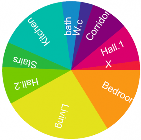
Table 2. Shows the J-graph analysis in 5 traditional dwellings (with one entrance) (Shallow type)
|
Depth of Shallow Planning Scheme |
|||
|
Photo |
Plan |
J-Graph |
Pie Chart |
|
1. |
|||
|
2. |
|||
|
3. |
|||
|
4. |
|||
|
5. |
|||
Table 3. Shows the J-graph analysis in 5 traditional dwellings (with one entrance) (Tree type)
|
Depth of Ring Planning Scheme |
|||
|
Photo |
Plan |
J-Graph |
Pie Chart |
|
1. |
|||
|
2. |
|||
|
3. |
|||
|
4. |
|||
|
5. |
|||
Table 4. Integration value of ring type dwellings
|
Integration |
||||
|
House No.1 |
House No.2 |
House No.3 |
House No.4 |
House No.5 |
Table 5. Integration value of shallow-type dwellings
|
Integration |
||||
|
House No.1 |
House No.2 |
House No.3 |
House No.4 |
House No.5 |
Table 6. Integration value of tree type dwellings
|
Integration |
||||
|
House No.1 |
House No.2 |
House No.3 |
House No.4 |
House No.5 |
In Tree pattern configuration, the entry hall and living area should have an integration value of 1.5-2.5, while the integration value for the bedroom and bathrooms should be between 0.5-1 (see Table 6).
5.3 Connectivity value
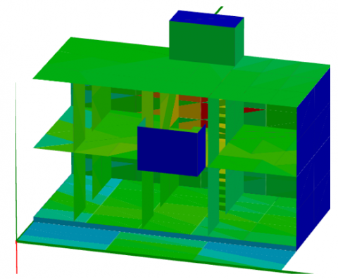
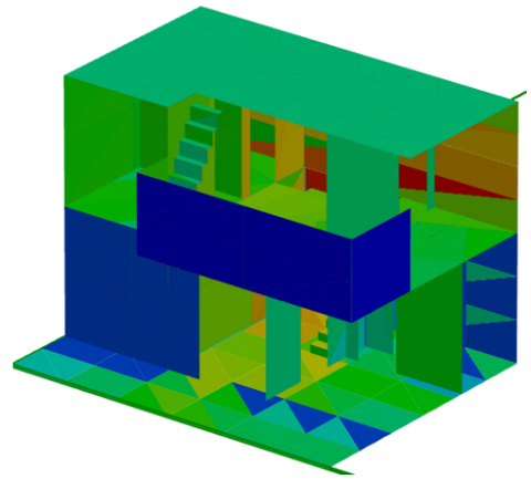
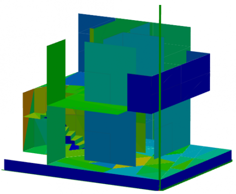
The DepthSpace3D simulation program displays the connectedness index using color-coded plans, which indicate the number of direct connections between areas inside the building envelope. The color red represents areas with high connectivity, while the color blue represents areas with poor connectivity. Regarding the socio-cultural concept of privacy, limited connection might symbolize a secluded area, akin to physically separated areas. In contrast, strong connectedness implies the presence of a public area or a venue that facilitates interaction via its physical structure. The connectivity of a place is determined by its ratio, size, location, and access points. The highest connectedness observed in the ring type of dwelling, hall, and stairs is 0.5 to 1.2. The moderately connected bedrooms, living area, kitchen, and porch are 1.3 - 1.8. However, the roof and bathrooms exhibit low connectivity, which is 1.9- 2.5, which means the lower value is the most connected space (see Table 7) While in shallow-type dwellings, the main hall, corridors, and staircases are highly interconnected with the value between (0.7-1.8), areas like the kitchen and living room the connectivity value between (2-2.4). while the store, porch, and bathroom have lower connectivity values between 2.5 and 2.8 (see Table 8). Tree-pattern dwellings exhibit lower spatial connectivity when contrasted with other architectural types. The central areas, such as the hall and the stairs, demonstrate a high degree of interconnection, with a value between 1.2 and 1.6. In contrast, bedrooms designed for privacy and seclusion show the least connectivity, at 2.5 (see Table 9).
6.1 Analysis degree of depth, integration, and connectivity
6.1.1 Depth
This type of configuration is commonly found in dwellings with two entrances. The main entrance is typically on Lower Street, while the secondary entrance is on Upper Street. This layout aims to create a seamless interaction between the dwelling and its surroundings, allowing for different access levels throughout the interior. The reason for this two-entrance configuration is the region's topography.
In this type of dwelling, the entry hall and stairs are low-depth, while the porch, roof, and store are the deepest. However, the first floor will be shallower or deeper depending on the entrance.
The two-entrance configuration creates a ring shape on a J-graph. More seclusion is provided as one moves away from the main areas, such as the bedrooms, kitchens, and living spaces. The baths, roofs, and porches are situated in the most isolated space of the dwelling, intended to provide the utmost solitude inside the residential complex.
(1) Depth of shallow planning scheme
These shallow patterns, meaning they are easily observable and navigable, unlike deeper, more enclosed spaces that may limit movement and social interactions. A shallow layout provides privacy and great space for necessary functions. Service rooms are intentionally placed on the ground floor while living rooms are situated on the first floor to ensure privacy and a good view. This design protects against street-level disturbances and optimizes natural light to enhance the peacefulness of living spaces. Shallow-style plans prioritize privacy and offer more spacious bedrooms and porches (Barbank) for a more comfortable living environment.
(2) Depth of tree planning scheme
In the case of a tree plan, the layout produces a form like a linear arrangement, which organizes spaces in a hierarchical organization from public to private space and may unintentionally cause difficulties in connectedness inside the complex. This may result in greater distances inside the dwelling and cause some rooms to feel isolated from the major social areas. for example, the bedroom is higher in-depth due to the linear arrangement and the last space to reach it. Based on what has been said thus far, the social significance of a place is greatly affected by its depth.
Depth makes a location seem more private and secluded, reducing its permeability. Spaces with more depth are often more private than those with less, making this idea especially pertinent in residences. Nevertheless, the public spaces with the least amount of depth are the entrance hall and living room. Among the rooms within, the kitchen is conveniently located. Nonetheless, the level of seclusion grows as one progresses farther into the dwelling, and the bedrooms and baths are the most private areas in the dwelling.
6.1.2 Analysis value of integration
(1) Integration of ring type dwelling
In the ring patterns, stairs and halls are pivotal nodes facilitating the highest degree of integration. The stairs connect two entrances. This type of spatial configuration is characterized by disparate entrances situated at different levels. However, the staircase and hall are crucial, connecting different spatial areas.
(2) Integration of shallow type dwelling
The investigation identified the corridor, hall, and stairs as integrated spaces as the main social areas in the shallow dwellings. The entry hall served as a main center for connecting different spaces and was a crucial distribution point. The street entrance design aims to promote a seamless indoor and outdoor transition by highlighting the connection between the spaces and the hall. This discovery highlights the establishment of a clear hierarchy of access to shallow dwellings, distinguishing between private, semi-private, and public spaces.
(3) Integration of tree-type dwelling
In this particular dwelling configuration, as one moves from the entrance hall into the more private spaces, such as the bathroom and bedroom, the level of integration in this style of living space gradually decreases. The bedrooms in such a dwelling are purposefully made to be separate rooms with little connection to the main area, so there is less integration overall. In terms of personal space, this setup is preferable.
The bedroom and other private areas provide a great deal of seclusion, which may help create the ideal environment for relaxation.
6.1.3 Analysis value of connectivity
(1) Connectivity of ring type dwellings
Based on the calculations, the hall and the stairs in this particular type of dwelling exhibit the maximum level of connectedness. Hence, the two places exhibit many interconnections with other spaces, and entry into the more profound realms occurs via these two spaces.
(2) Connectivity of shallow type dwelling
The halls, corridors, and stairs in shallow-type dwellings are highly interconnected. Therefore, shallow planning implies privacy whenever necessary. the service rooms on the ground level to unite with the site topography, while the living rooms are located on the first floor to provide enough privacy and a stunning view.
(3) Connectivity value of tree plan dwelling
These types of dwelling units lack spatial connectivity. the hall and stairs are both the most connected. Since bedrooms and porches are the most private.
Table 7. Connectivity value of ring-type dwellings
|
Connectivity |
||||
|
House No.1 |
House No.2 |
House No.3 |
House No.4 |
House No.5 |
Table 8. Connectivity value of shallow-type dwellings
|
Connectivity |
||||
|
House No.1 |
House No.2 |
House No.3 |
House No.4 |
House No.5 |
Table 9. Connectivity value of tree-type dwellings
|
Connectivity |
||||
|
House No.1 |
House No.2 |
House No.3 |
House No.4 |
House No.5 |
The study examines the compositional and structural characteristics of mountain city buildings in general and explores the spatial patterns of traditional dwellings in the Old Akre City as a case study. It reveals the extent to which the spatial configurations of these dwellings are deeply intertwined with the local social ecosystem, cultural climate, and natural surroundings. The main variables associated with these configurations, including connectivity, depth, and integration values, were analyzed using 3D space syntax.
The study identified three basic spatial patterns: the ring pattern, the shallow pattern, and the deep pattern (tree). Each of these styles is uniquely suited to the mountainous terrain and community needs. The annular pattern was characterized by its compatibility with the mountainous terrain through two entrances at different levels. In contrast, the shallow pattern was unique in that it focused on the open pavilion area used for gatherings and social activities, enhancing social interaction and effectively using spaces without excessive focus on the topography. As for the tree pattern, it was found that the spaces in traditional dwellings are organized hierarchically from public areas to private areas. Which leads to merging with the natural terrain and creating a living space.
Therefore, the layout is adjusted to the sloping topography, helping the design achieve better flow and accessibility while creating a smooth transition from public areas to private ones.
However, the structural features of the community include diverse spaces serving distinct purposes. The research classified the spaces of those dwellings as integration spaces, such as living rooms, and staircases that facilitate social interactions and cultural exchanges, symbolizing seamless transitions between social, cultural, and spiritual dimensions. Isolated spaces like bedrooms and porches prioritize privacy and personal contemplation while maintaining links with cultural aesthetics, acknowledging the importance of personal space for individual well-being within the community. Service spaces like bathrooms and toilets present a practical approach to cleanliness. Integrating function and environment through architectural elements such as landscape and building form becomes the basis of a well-adapted service space.
The researchers recommend taking advantage of their conclusions in developing the city of Dohuk. as its the site's characteristics are similar to those of the city of Akre, reflecting the architectural and cultural identity of the mountainous region.
We would like to express our deep gratitude to Franklim Morais for his guidance in instructing us on the usage of DepthSpace3D, which he himself developed.
[1] Fu, J., Zhou, J., Deng, Y. (2021). Heritage values of ancient vernacular residences in traditional villages in Western Hunan, China: Spatial patterns and influencing factors. Building and Environment, 188: 107473. https://doi.org/10.1016/j.buildenv.2020.107473
[2] Al-Mohannadi, A.S.M.A. (2019). The spatial culture of traditional and contemporary housing in Qatar. A comparative analysis based on space syntax. Master's Thesis, Master of Urban Design and Planning (MUPD) Program, Department of Architecture and Urban Planning, College of Engineering, Qatar University.
[3] Fithra, H. (2019). Hasil Cek similarity Artikel "The typology of the Gayo traditional house facade is reviewed based on the context of the form element analysis". http://repository.unimal.ac.id/id/eprint/4318.
[4] Khani, A. (2015). Appreciation of nature in architecture: Interaction between topography & design in the case of Karmi (Karaman) Village, North Cyprus (Master's Thesis). Eastern Mediterranean University EMU.
[5] Oveisi Keikha, Z., Kavosh, H., Heidari, A., Davtalab, J. (2020). A typology of sistan's vernacular housing in terms of open and closed space formation. Journal of Housing and Rural Environment, 39(171): 61-72.
[6] Shahbazi, M., Bemanian, M.R., Lotfi, A. (2018). A comparative analysis of spatial configuration in designing residential houses using space syntax method (Case studies: Houses of Isfahan and modern architecture styles). International Journal of Applied Arts Studies (IJAPAS), 3(1): 21-40.
[7] Beycan, A.D.O., Özmertyurt, G. (2018). Residential architecture of Botsa rural settlement in Konya-Turkey. IOSR Journal of Humanities and Scocial Science, 23: 2279-0845.
[8] Beyti, H., Pourjavad Asl, B., Gharehbaglou, M., Naseri, H. (2021). The effect of climate on the spatial organization of rural housing based on the theory of space syntax (Case study: Villages of East Azerbaijan province). Journal of Rural Research, 11(4): 746-765. https://doi.org/10.22059/jrur.2020.306250.1533
[9] Huang, B.X., Chiou, S.C., Li, W.Y. (2019). Study on courtyard residence and cultural sustainability: Reading Chinese traditional Siheyuan through space syntax. Sustainability, 11(6): 1582. https://doi.org/10.3390/su11061582
[10] Abohorlu, P., Kurt, S. (2017). Traditional earth sheltered buildings on five finger mountain (Cyprus); Evaluation of the energy efficiency by computer simulating the rectangular plan typology. Prostor: Znanstveni Časopis za Arhitekturu i Urbanizam, 25(53): 98-111.
[11] Eruzun, Z.A.K., Saatçi, S. (2021). An analysis of the plan and facade typologies of boyabat’s traditional turkish houses. https://www.ceeol.com/search/article-detail?id=1001744.
[12] Biçer, Ö.P. (2019). Comparison of a historical and a modern building according to ecological criteria. Eurasian Journal of Civil Engineering and Architecture, 3(1): 27-48.
[13] Ceko, B., Beqiri, L. (2022). Vernacular dwelling from anatolia to the balkans; A comparison between safranbolu and prizren. Journal of Applied Sciences-SUT (JAS-SUT), 8(15/16): 23.
[14] Turgut, D. (2019). An analysis of the plan typology of vernacular Talas Houses. A| Z ITU Journal of the Faculty of Architecture, 16(1): 117-125. https://doi.org/10.5505/itujfa.2019.08379
[15] Hillier, B., Hanson, J. (1989). The Social Logic of Space. Cambridge University Press.
[16] Rasul, H.Q., Ahmed, A.I. (2018). Nature and physical configuration: A study of topographical influences on the physical configuration of mountain settlements in the Iraqi Kurdistan region. In Cities' Identity Through Architecture and Arts: Proceedings of the International Conference on Cities' Identity through Architecture and Arts (CITAA 2017), Cairo, Egypt, p. 275. https://doi.org/10.1201/9781315166551-27
[17] Fikry, A.A., El Zafarany, A.M., Nabil, H.A. (2019). The classification of mountainous buildings. Journal of Al-Azhar University Engineering Sector, 14(50): 289-310.
[18] Ascensão, A., Costa, L., Fernandes, C., Morais, F., Ruivo, C. (2019). 3D space syntax analysis: Attributes to be applied in landscape architecture projects. Urban Science, 3(1): 20. https://doi.org/10.3390/urbansci3010020
[19] DepthSpace3D. http://depthspace3d.cyberoikos.com/pages/p09.aspx, accessed on May. 10, 2024.
[20] Morais, F., Vaz, J., Viana, D.L., Carvalho, I.C., Ruivo, C., Paixão, C., Gomes, T. (2017). 3D space syntax analysis. Case study: Casa da musica. In Proceedings of the 11th Space Syntax Symposium, Lisbon, Portugal: Departamento de Engenharia Civil, Arquitetura e Georrecursos, Instituto Superior Técnico, IST-UL, pp. 11-13.
[21] Hillier, B. (2009). Spatial sustainability in cities: Organic patterns and sustainable forms. Royal Institute of Technology (KTH).
[22] Hillier, B., Hanson, J., Peponis, J. (1984). What do We Mean by Building Function? E & FN Spon Ltd.
[23] Hillier, B. (1996). Cities as movement economies. Urban Design International, 1: 41-60.
[24] Phuong, P.P. (2022). Characteristics and typology of ethnic housing based on spatial configuration in Vietnamese Mekong delta. Doctoral Dissertation. Department of Architecture and Civil Engineering, Graduate School, Chonnam National University.
[25] Malaika, M.J., Raswol, L. (2014). Activating heritage tourism in Akre city by applying sustainable ecotourism approaches. European Scientific Journal.
[26] Ismael, S.Y., Hasan, B.J. (2023). The role of collaboration in survey and documentation of historic buildings. Case study: Akre historic area in Kurdistan region of Iraq. Academic Journal of Nawroz University, 12(4): 845-967. https://doi.org/10.25007/ajnu.v12n4a1669
[27] Ismael, S.Y. (2015). Promoting integrated heritage conservation and management in Iraqi Kurdistan Region: Applicability of values-based approach the case study of Akre and Amedy City in Duhok Province (Doctoral dissertation, Technische Universität Dortmund).