Mohamed Adel Abd El Aziz Mousa*![]() | Samy Ammer
| Samy Ammer![]() | Mohamed Ali Ibrahim
| Mohamed Ali Ibrahim![]() | Walid Bayoumi
| Walid Bayoumi![]()
© 2024 The authors. This article is published by IIETA and is licensed under the CC BY 4.0 license (http://creativecommons.org/licenses/by/4.0/).
OPEN ACCESS
Researchers, governments, and international organizations have all been working to understand the various functions, types, and levels of these centers. Despite these efforts, there has been little progress in developing assessment criteria that consider multi-aspects of logistics centers such as function, level, and spatial relationships perspective together. This study seeks to bridge the research gap by using a multi-criteria evaluation framework and applying Damietta Port as a case study. To achieve the main objective which is to test the ability of Damietta Port to play its role as a logistic hub by comprehensive multiple criteria. Some efforts have crystallized around evaluating using the criteria matrix. However, it does not comprehensive. However, the matrix table consisting of multiple criteria is developed, comprehensive and more organized, and through it we can evaluate the Port. By secondary sources the data were collected through statistical reports issued by official authorities, then relied on statistical analysis of this data and visualized to assist in understanding the results. The result shows that Damietta Port can play a role as a logistical hub. This assessment helps governments take appropriate decisions to make these centers play a development role that suits their logistical functions and norms within their spatial urban sphere. Damietta's port can be a manner of supporting the preparation of strategic plans for the cities that surround the port. The findings of this paper lead to an exploratory framework that advances our understanding of the functions and impacts of logistic hubs.
logistics typology, logistics level, logistics functions, strategic logistics planning, main port logistics, logistic hub, logistic city, spatial multi-criteria analysis, sustainable development, logistic network
While academics and public and private sector actors are becoming increasingly interested in logistics centers, there is still no unified definition. Some of the definitions available refer to a center for activities related to transportation and logistics, while others define it based on the function provided by the place, such as freight villages in Europe, Japan, Singapore, China, and the United States. These centers are complex and integrated systems that include transportation services, freight forwarding, warehousing, and value-added services. So, it has centralized locations, interstitial locations, and gate locations. Such hub provides services such as warehousing, storage, and even manufacturing, so it can provide a one-stop solution for companies looking to move their goods efficiently and cost-effectively. It is also an integral part of the global supply chain [1].
As a term, the logistic center is not new. The American Heritage Dictionary defines it as the center that carries out a wide range of logistic functions and commercial operations. Logistics centers can provide a range of services, such as warehousing, distribution, market analysis, and transportation management. In addition, they can be used for inventory control, order fulfillment, and supply chain management. This definition combines "logistics", which includes all the processes needed for the provision of products or services, excluding producing the goods or performing the services, on the one hand, and "center" which refers to a place where a specific activity is concentrated [2]. It is seen as the hub of a specific area where all the activities relating to transport, logistics and goods distribution – both for national and international transit – are carried out, on a commercial basis, by various operators [3].
A port is an area where ships come to load and unload goods. It is usually located near large bodies of water such as oceans, seas, and rivers, and they provide a critical link to the international trade of goods. So, port cities are an integral part of the global economy. They provide a platform for trade and commerce, connecting producers and consumers around the world, and creating jobs and economic opportunities for local communities.
The concept of a logistic center is based on three pillars:
(1) Territorial planning alongside infrastructure rationalization
(2) Transport quality
(3) Intramodal development
- The concept of territorial planning implies that a specific area must be dedicated to logistics, transport, and distribution to enable the center to include activities and facilities based on the type of transportation and transit. Any city and region's infrastructure depends on this type of planning, and it ensures that goods and services are delivered efficiently and quickly to those who need them and promotes economic development. To optimize the area's utilization, it is necessary to plan the territory and rationalize infrastructures, safeguard the environment (by moving heavy traffic from residential areas to the logistics center), and optimize relations between the logistic center and the surrounding areas and cities.
- Transport quality is an important factor for achieving regional competitiveness between production areas [3]. Transport quality is achieved by reducing transportation costs and accessibility, which is a link between transportation and land use and has recently been used effectively as a planning tool that controls land use [4].
- Intramodal development is a significant aspect of modern logistics centers. Road transport is still the most common mode of transportation, and its demand has been increasing steadily over the past 20 years. In contrast, rail freight transport has decreased steadily. Therefore, logistics centers must focus on bringing together freight transport flows by multimodal transport on long-range journeys, including rail, road, and sea-shipping.
Rail transport offers several advantages over road transport, including capacity, energy efficiency, and a reduced carbon footprint. However, it is not always suitable for short-distance transportation or for transporting perishable goods. Road transport, on the other hand, is more flexible and can provide door-to-door delivery. Sea shipping is also a major mode of transport, especially for international trade. It offers the advantage of transporting large quantities of goods over long distances at a lower cost. However, it is not always the fastest mode of transport, and delivery times can be longer. So, by utilizing multiple modes of transportation, logistics centers can ensure efficient and cost-effective transportation of goods, while also improving reliability and generating other relevant effects from economic and transport standpoints.
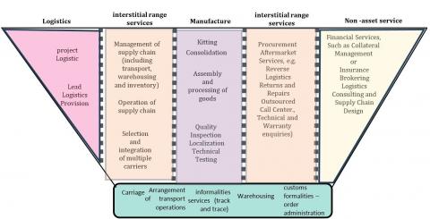
There is a wide range of logistics services. It consists of three groups: logistics (referring to more developed transport, warehousing ...etc.), manufacturing (the services relating to further processing of goods which give value added), and non-asset services (involving a range of services relating to management and operations). The services fall in between the categories so should be interpreted as a spectrum rather than a categorization [5].
Moreover, it is important to recognize that these services are often intertwined, and that there is often overlap between the ranges. this wide range of services was an important reason for the emergence of relationships between many flow points to complete the tasks of the integrated logistics supply chain framework (see Figure 1).
Figure 1. The wide range of logistics services
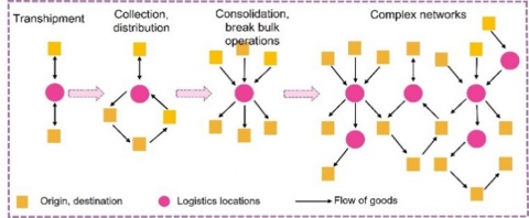
According to functions and overlapping between tasks ranges, logistical relations are diversified to include several forms, starting with basic tasks performed in warehouses to achieve industrial or distribution needs such as (pick-up of goods, consolidation/deconsolidation, change from one means of transportation to another, and storage). Ending: More complex logistical tasks are available in a multi-party network because it demonstrates more interactions occur (Figure 2) [6].
Figure 2. The basic network
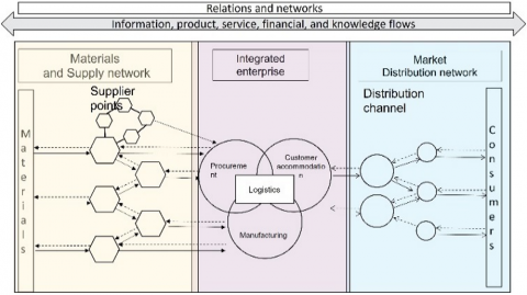
The logistical network can be divided into three sections for more detailed information on the points and their basic and complementary logistic relations. The first is a network of suppliers and materials, while the second section is the manufacturers, Procurement, Customer The third section is the Market distribution network, considering the availability of information, product, financing, and knowledge that allows the flow (Figure 3) [7].
Figure 3. The Integrated supply chain network
By taking an urban perspective into account, this network can embody urban relations. The spatial relationship is considered a reflection of the previous two relationships, as large-scale relationships and networks led to the need for territorial planning, in the form of interacting areas, cities, ports, terminals, etc. This is due to the need for these services and activities to have spatial space to allocate these functions. It is possible to achieve the supply chain by drawing a map from material sources to production inputs and markets and adding value to the chain industries by linking firms located in secondary cities which are too small to operate at scale, but they can support national export development or import products and services by collaborating with firms located in metropolitan regions to create value and overcome scale and barriers of entry to markets (Figure 4) [8].
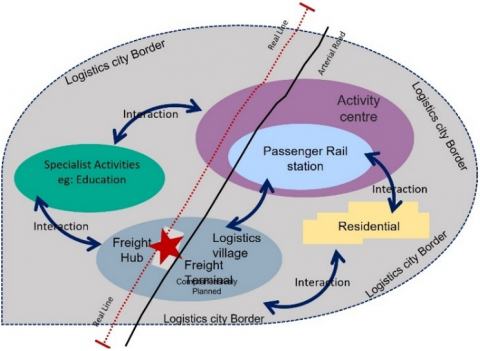
Logistics cities and logistic hubs are a type of urban form. The logistic city is a geographical metropolitan area containing several logistics nuclei, one of these being a massive international freight hub associated with a critical volume of multimodal transport and gateway infrastructure. It owns many facilities (roads, railroad tracks, terminals, and ICT) and substantial logistics services (warehousing − including cold storage − freight forwarding), and related business value-add services and social infrastructure (education and recreation) (Figure 5). For example, Dubai, Shanghai, Singapore and others in the United States and Europe are logistic cities. These cities have urban amenities, business services, infrastructure, and significant economic growth potential. In addition, they can attract investments and projects from leading international and local logistics companies.
Figure 4. The interactions between cities and metropolitan regions
Figure 5. The framework of a logistics city
As for the logistics hub, which is simplistically defined as an integrated center for the transshipment, storage, distribution, and collection of goods, it is classified at an international level [9]. The reflection of logistical interactions with urban development takes many forms and is not finished but it is not the focus of this paper. The hub is also essential for the development of the city. It is considered part of the logistics city and its international nucleus. It has great development advantages such as increasing the efficiency of goods and services transportation, thus contributing to economic growth. It likewise increases the city's competitiveness on the international market and attracts investment and can reduce the environmental impact of transportation. It can also act as a catalyst for urban regeneration and create a more livable city by creating new job opportunities for the local population.
Logistic interactions occur inside a spatial range measured by a specific distance from the logistic platform location. This distance is measured according to the center level. These logistics concentric circles were identified by level through one of the workshops, with the Egyptian Ministry of Transport, as follows [10]:
·National-international: 50-100 km
·Regional: 20/50 km
·Urban and metropolitan: 10/20 km
Therefore, two things become clear: the physical interactions that occur through the network must take place through the variety of modes of transportation to suit all types of goods and materials at specific distances and ranges determined by the level of logistical center.
By defining the scope of influence and interaction the framework of geographical areas is clear. It allows for a better understanding of the scope of logistics services provided. It also provides insights into the types of goods, material sources and services offered within each range. Additionally, it directs to the necessity of determining the level of the logistics center and then defining criteria that help in building the comprehensive framework for evaluating the logistics hub.
The level of the logistic center is an important criterion because it is the first criterion that proves the ability of the center to be a logistic hub. This contributes to the main goal of the paper, which is to develop a comprehensive framework of evaluation criteria for the port and identify deficiencies in capabilities to guide governments and decision-makers’ priorities for intervention and development.
Table 1. Ricard's criteria of logistic levels
|
Factors |
Level 3 |
|
|
A |
Geographical coverage |
inter-continental level |
|
B |
Transport modes and corridors |
more than two transport modes |
|
C |
Third party logistics services |
a strong presence of TPL services which are seen as a core component |
|
D |
Value added logistics service |
semi-manufacturing assembly of parts, product customization |
|
E |
Commercial and public services |
a variety of facilities and services that can be used by communities |
|
F |
Customs and administration |
custom clearance services are well established |
|
G |
Marketing |
actively engaged in marketing the lc, dedicated unit for marketing purposes in a wide network |
Richard commented on determining the logistic center level through six criteria. Table 1 shows that these criteria are as follows (Table 1) [11]:
A - Geographical coverage
B- Transport modes and corridors
C- Third party logistics services
D - Value added logistics services
E - Commercial and public services
F - Customs and administration
G - Marketing
H - Horizontal collaboration and networks
Based on Ricard's analysis of the criteria, the logistic facility is divided into three clusters:
Level 1: is focused on transportation, logistics activities and limited additional functions that are not related directly to these activities (inventory management, order picking, inspection, quality control, packaging, bar-coding).
Level 2: acts as a trade facilitator with customs clearance functionality and a strong focus on value added services (adding parts, maintenance and repair, testing, installing, adding instruction manuals).
Level 3: is the comprehensive logistics center that is yet the most advanced which covers the most functions and has high value added (goods processing, semi-manufacturing, final assembly, reverse logistics, Product customization). Therefore, the third level of Richard's classification can be considered the logistic hub.
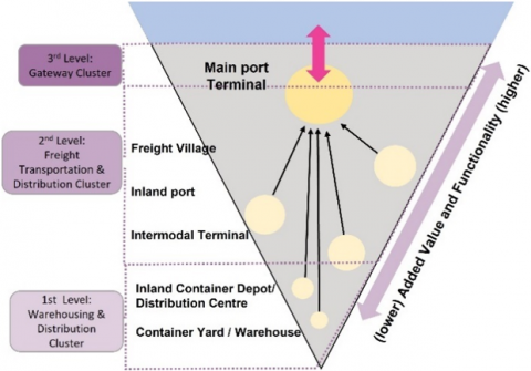
Also, Higgins [1] agreed with Ricard that the Logistics Hierarchy should be grouped into three levels, but he focused on the functional aspect of each level and categorized for the logistics center according to that function (see Figure 6) [1]. He also argued that it is important to determine the type of logistics center, as this will affect its location, volume of flows, and tasks in the supply network. These standards contribute to the second dimension (functional aspect) of the comprehensive evaluation framework.
Figure 6. The Hierarchy level of a logistics centers
Level 1: Warehousing and Distribution: It represents the smallest scope of activities performed by intermodal logistics centers. Warehousing and distribution centers perform a variety of logistics functions and serve as key basic elements in the supply chain.
Level 2: Freight Distribution: It encompasses Intermodal Terminals, Inland Ports, and Freight Villages, and covers medium and large terminals. These facilities perform activities ranging from the simple transfer of goods to an intermodal terminal. They also offer a broad range of intermodal transportation options, a wide geographical reach, and comprehensive value-added services.
Level 3: Gateways: It defines the largest scope of activities contained within major international main port terminals. It encompasses facilities called XXL and XL terminals, Logistics Nodes and Gateways.
Research entities like the Royal Institute of Technology in Stockholm, Sweden have conducted extensive studies in this field. Their expertise and findings have helped shape our understanding of logistics center criteria and factors. By considering their research and insights, we can gain added elements that researchers have not addressed that feed the level, function, and open the door to spatial evaluation items which consider the last element of comprehensive evaluation building [12]:
A- Proximity to market: Market reach, one-day market reach: measured by population concentration within a 600-mile (nearly 960 km) radius in the region.
B- Land Availability: Land available for development, based on vacant land, land available for re-development, Average land value.
C- Government support of transportation developments and size of regional transportation/ distribution: Identify regional economic development councils, especially those with transportation emphasis, which is measured by the number and size of employment in local industry.
D- Labor Supply: Industrial labor supply able to meet expanding transportation developments: Identify the proportion of a region's workers with transportation jobs.
Although researchers agreed on some criteria such as infrastructure, port capacity and their frequency of shipment per year, workforce, proximity to market and railroad infrastructure, there were additional criteria to evaluate the operational performance efficiency, all agreeing with the previous measurement method, so it is a repeated element: (warehouses, supplying areas, Population Density, development costs, multimodal transportation, telecommunications, taxes, and fares). The proximity of residential location can be viewed as a spatial item added to the spatial dimensions [4, 13].
The efforts of researchers in this field continue to present factors, but they revolve around one vision, such as Ability to Access Key Markets or Customers, Interaction with Transportation Network, Labor and Workforce, Total Cost Environment, Availability and cost of Suitable Facilities, Utilities, Permitting and Regulation, Tax Environment, Public Sector Assistance and Incentives and Climate and Natural Hazards, but there is an addition of priorities that clarify the importance of factors over others from the perspective of the hub needs, where the factors are classified into important, primary and less factors (see Table 2) [6, 14-16].
Table 2. Royal Institute's criteria of logistic levels
|
Location Criteria |
Hub Terminal |
|
Ability to Access Key Markets or Customers |
important factor |
|
Interaction with Transportation Network |
primary factor |
|
Labor and Workforce |
important factor |
|
Total Cost Environment |
primary factor |
|
Availability and Cost of Suitable Facilities |
important factor |
|
Utilities |
lesser factor |
|
Permitting and Regulation |
lesser factor |
|
Tax Environment |
lesser factor |
|
Public Sector Assistance and Incentives |
lesser factor |
|
Climate and Natural Hazards |
important factor |
Based on extensive literature, we assume efficient performance entails developing a new framework that includes a discussion of several aspects and visions based on multiple criteria that show the level and functions within its scope of influence and spatial relations. All agreed on a comprehensive evaluation together to achieve effective performance. We will use a matrix to collect all the criteria and their indicators and measure them. Those that can assess Damietta Port's ability as a logistics hub, identification of its shortcomings, and determination of development priorities. Other logistic center types and duplicate criteria have been excluded since we are targeting only logistics hubs. The three dimensions form three groups. Each of them consists of indicators that will be measured statistically based on the reports of official authorities, all of which are legal, such as (features of future planning for Damietta Governorate 2032 - General Authority for urban Planning & Trends in Egyptian exports 2020 - Ministry of Trade and Industry & Movement of Egyptian sea ports - Maritime Transport Sector at the Ministry of Transport 2021 & Population Census - Central Agency for Public Mobilization and Statistics).
The method is applied in four steps: 1) study area characterization: to know the character, the location of the port and its spatial relationships; 2) define criteria and data collection: Projecting the various standards that were formulated from the literature on Damietta Port with the aim of identifying the port’s character in terms of its various capabilities, as well as the shortage that will need intervention and development, in light of the targeted standards and the goal of the study in order to evaluate Damietta Port through comprehensive standards; 3) Evaluation of indicators: by Indicators value from the official statistics reports the data are analyzed statistically and using the graphical representations whenever possible; and 4) The results Figure 7 shows that.
Figure 7. The framework for measuring efficient performance for Damietta Port as a logistical hub
2.1 Study area
Location: Damietta Port is located 40 km west of the mouth of the Damietta branch on the Mediterranean Sea. It is 70 km away from Port Said Port, and it is subject to the Damietta Port Authority. It is a major port for exporting products and importing raw materials and brands. It has 28 berths with a length of 6,600 meters and a depth of 15 meters. Damietta Port Authority ranked third in ship frequencies in 2021. The Damietta Port Authority has recently restored river transport unit movement across the Nile River in a project with the National Nile River Transport Company [17].
The port component: The port contains a channel 11.4 km long and 300 meters wide, gradually decreasing until it reaches 250 meters at the breakwater with a depth of 15 meters. The channel is bordered by 18 buoys (buoys) lit at night [18].
It contains the sandal channel, which consists of two parts. One is 1350 meter long, connecting the barge basin with the sea. The second is 3750 meters long, connecting the basin with the Nile branch. The barge basin area is (250 * 250) meters and is equipped with a berth of 250 meters in length, and the water depth is 5 meters, and the diameter of the basin is the turn is 500 meters, and its depth is 14.5 meters in front of the container berth, and its depth is 12 meters in front of the general cargo berth [18].
2.2 Define criteria for data collection
Existing areas and future extensions: The port facilities cover an area of 11.8 square kilometers, while the current water surface area is 3.9 million square meters and will increase in the future to 4.3 million square meters, while the current land surface area is 7.9 million square meters and will increase in the future to 8.6 million square meters. The following (Table 3) shows the distribution of the port elements areas according to data from the Maritime Transport Authority [18].
Table 3. The distribution of the areas
|
The Area in (m2) |
Element |
|
11870547 |
Total area |
|
8539309 |
Floor area |
|
3331238 |
Water area |
|
281546 |
The Total Area of Stores and Sheds |
|
833834 |
The total area of the squares |
Logistics and river transport capabilities: The port includes logistical components such as handling at 96 points for refrigerator containers, 10 rail-mounted cranes, 10-yard cranes, all vertical loading cranes, forklifts, and trailers. In addition, a navigational channel links the port with the Nile River, with a length of 5.4 kilometers and a width of 90 meters. And a depth of up to five meters. The maximum design capacity is 19.75 million tons per year. The following Table 4 shows the maximum capacity for different types of flow. The port has 19 berths of different lengths. Table 5 shows the patterns used by port berths [18].
Table 4. The maximum capacity for different types of flows
|
Quantity in Tons and Equivalent |
TYPE |
|
7 million |
General Goods |
|
7.5 million |
Dry bulk |
|
5.25 million It is equivalent to 1.2 million containers |
Containerized goods |
Table 5. The maximum capacity for different types of flows
|
Long (m) |
Depth (m) |
Customize |
The Number of Repetitions |
TYPE |
|
1050 |
14.5 |
1-2-3-4 |
4 |
Containers |
|
800 |
12 |
5-6-7-8 |
4 |
General Goods |
|
900 |
12 |
9-10-11-12 |
4 |
Dry and liquid bulk goods |
|
600 |
14.5 |
13-14 |
2 |
Yield |
|
600 |
14.5 |
15-16 |
2 |
Multifunctional |
|
1150 |
14.5 |
- |
3 |
Gas |
|
5100 |
|
- |
19 |
Total |
There is also a container terminal at the port. It is one of the most prestigious terminals in the region. There are four container berths with a length of 1050 meters and a depth of 14.5 meters. It occupies an area of 465 thousand square meters, with an area of approximately 800 thousand square meters for future expansion. The port container terminal is equipped with 10 cranes, and the terminal is handled by a team of professionals. It was provided with an information system that helps plan and monitor yards, ships, railways, and container handling equipment. A cost estimate for its development has also been compiled. With 600 million pounds, a memorandum of understanding was signed with German operator Euro Gate in September 2019. This was followed by investment costs of 750 million euros to develop the second container terminal at the port.
There was an area for storage and frozen goods of 3,000 square meters, another area for wood, steel, and foodstuffs of 3,000 square meters, and a port that also contained a grain city, with berths 600 meters long and 14.5 meters deep, a silo with a capacity of 150,000 tons annually, and a shed for statistics with an area of five thousand meters, with a daily capacity of three thousand tons.
The free zone in the port, an area of 798 thousand square meters for industrial printing and storage, exports without a tariff. In addition, it includes the construction of the investors' building, which includes all investment activities in the port. This is on an area of 60357 square meters, with 235 administrative units.
Cooperation took place between the Ministry of Transport and the Engineering Authority of the Armed Forces to create multi-purpose berths with a length of 680 meters, with a rear trading yard of 70,000 square meters and a warehouse for storing goods with an area of 5,000 square meters, with a handling capacity of 3.4 million tons annually, and a storage capacity of 4 million tons annually.
Multimodality: The main port relates to the national network, with a land and road network being developed. Damietta Governorate is continuing development work in this regard (February 2022), where the port road, which is 2.5 km long, will be duplicated and upgraded, starting from the Al-Sananiyya passage area until the port's outbound gate, which is being implemented through the Public Authority for Roads and Bridges after its inclusion in the Ministry of Transport's plan, to raise its efficiency and pave it with concrete slabs.
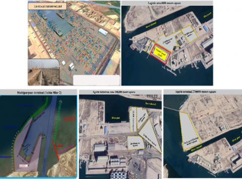
Development plan: As for the investment opportunities in the port of Damietta (see Figure 8), they were as follows [17].
· Grain industries zone 108,000 meters square
· Agarin terminal 2700000 meters square
· Logistic area 6000 meters square
· The second container terminal has 4.5 million equivalent units
· Multipurpose terminal (Tahia Misr 2)
Figure 8. The investment opportunities in the port of Damietta
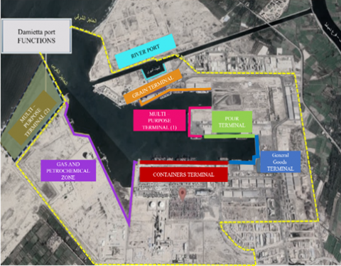
Added value: There were added value industries related to grain and petrochemical, so they settled in complementary areas (see Figure 9). One is located in the grain industries zone, while the other is in the petrochemical complex.
Figure 9. The land use of Damietta Port
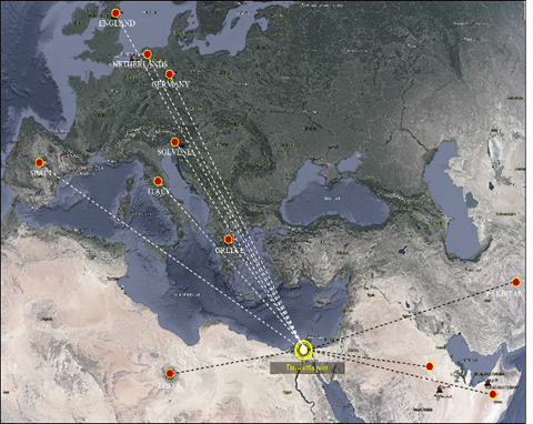
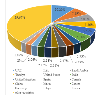
International flows: The exports are varied, such as vegetables (parsley, frozen okra, artichokes, potatoes, yams, frozen mixed vegetables), agricultural crops (peanuts, garlic, basil, herbs, olives, alfalfa, onions, lemon, caraway), and fruits. Including orange, strawberry, tangerine). Imports were also concentrated on scrap goods, corn, soybeans, and oven slag. While exports were concentrated on liquefied gas, fertilizers, and molasses [17]. Many external flows in Europe and Asia reach 3500 KM, such as Emirates, Jordan, Germany, England, the Netherlands, Greece, Pakistan, America, Belgium, Slovenia, Spain, and Malta (see Figure 10). The port can export to seven international markets, which are the most significant markets for Egypt according to 2021 statistics [19] Table 6 (see Figure 11). These markets are in Europe, Africa, and Asia, which means that Egypt can take advantage of the geographical proximity of these countries to export its goods. Additionally, the port has the capacity to handle large shipments, which provides an efficient and cost-effective way of transporting goods to these markets.
Figure 10. The international flow coverage to Damietta Port
Figure 11. The important export markets for Egypt 2020
The port’s performance decreased in 2021 compared to 2020, regarding the total frequency of ships (8%), which is less than the average of the Republic (10%), while the performance developed in Total cargo (million tons) at a growth rate of 16%, which is 12% higher than the average of the Republic. And the growth rate decreased in relation to the number of containers with a growth rate of total containers (million TEU) of -6%, which is lower than the rate of the Republic by -4% [17] (Table 7). The decrease in the frequency of ships can be attributed to the restrictions implemented due to the COVID-19 pandemic, which affected maritime transportation globally. The decrease in the growth rate of total containers is likely due to the decrease in the frequency of ships, as fewer ships mean fewer containers.
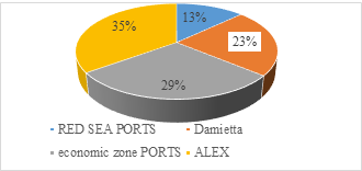
The Damietta Port Authority is ranked third in relation to Egyptian ports. It was the penultimate with 23% of the total ship frequencies, where the largest share was in favor of the General Authority of Alexandria Port with 35%, followed by the ports of the economic zone with 29%, and finally the Red Sea Ports Authority with 13%, respectively [17] (Figure 12).
Figure 12. Percentages of ship frequencies in Egypt 2021
The volume of imported goods amounted to 19,759.3 thousand tons (51.98%), while the exported amount was 18,257 thousand tons (48.02%). The largest share was dry bulk 51.28%, then general goods 19.51%, then transit 16.28%, and finally pour liquid 1.75% [17] (see Figures 13 and 14), Table 8 shows the volume of Goods handling in Damietta Port.
During 2021, Egyptian ports processed nearly 7.2 million containers, compared to 7.6 million containers in 2020 (which reflects the repercussions of the COVID-19 pandemic crisis). The largest share was in favor of the ports affiliated with the economic zone, which includes “East, West Port Said, and Sokhna,” with handling 4.8 million containers, equivalent to 66% of the total containers handled in Egyptian ports. Followed by the Alexandria Port Authority with a percentage of 20%, and finally the Damietta Port Authority with a percentage of 14% [17] (see Figures 15), Table 9 shows the Percentages of containers in Damietta Port 2021.
Figure 13. Percentages of flow in Damietta Port 2021
Figure 14. Distributions of flow in Damietta Port 2021
Figure 15. Percentages of containers in Damietta Port 2021
Internal flows: It means all goods and materials that are delivered from neighboring areas inside the country to the port. The main point in determining the scope of the internal flow of the port of Damietta is achieving the lowest logistical cost, of which the cost of transportation is considered one of them. In addition, there are guidelines received from the workshops of the Egyptian Ministry of Transport. So, when looking at the map of Egypt, it becomes clear that the governorates of Lower Egypt in the Delta will depend on the ports of the Mediterranean. Provided that the least distance must be traveled when the port specializes in the type of merchandise to be exported. As for the governorates of Upper Egypt, they will be dealt with by the ports of the Red Sea. This is considering the current state’s directions regarding the transverse linking of the governorates of Upper Egypt with the ports of the Red Sea.
Table 6. The most important export markets for Egypt
|
The Most Important Export Markets for Egypt (Million Dollars) |
|||||
|
Country |
2019 |
% |
2020 |
% |
Growth Rate |
|
UAE |
2062.42 |
6.63% |
2882.63 |
10.20% |
39.77% |
|
Italy |
2613.48 |
8.41% |
2032.59 |
7.19% |
-22.23% |
|
Saudi Arabia |
1695.3 |
5.45% |
1700.62 |
6.01% |
0.31% |
|
Türkiye |
1745.28 |
5.61% |
1657.7 |
5.86% |
-5.02% |
|
United States |
2191.5 |
7.05% |
1575.5 |
5.57% |
-28.11% |
|
India |
1580.17 |
5.08% |
1465.16 |
5.18% |
-7.28% |
|
United Kingdom |
1520.26 |
4.89% |
771.23 |
2.73% |
-49.27% |
|
Spain |
936.54 |
3.01% |
714.71 |
2.53% |
-23.69% |
|
Canada |
754.8 |
2.43% |
699.37 |
2.47% |
-7.34% |
|
China |
608.04 |
1.96% |
652.49 |
2.31% |
7.31% |
|
Malta |
1013.7 |
3.26% |
616.24 |
2.18% |
-39.21% |
|
Greece |
717.65 |
2.31% |
607.47 |
2.15% |
-15.35 |
|
Germany |
754.48 |
2.43% |
582.2 |
2.06% |
-22.83 |
|
Libya |
802.16 |
2.58% |
564.9 |
2% |
-29.58% |
|
France |
688.47 |
2.21% |
532.89 |
1.88% |
-22.60% |
|
Other countries |
11405.06 |
36.68% |
11217.32 |
39.67% |
-1.65% |
|
Total |
31089.29 |
100% |
28273.03 |
100% |
-9.06% |
Table 7. Performance indicators (2020-2021) for Damietta Port
|
Performance Indicators (2020-2021) |
||||||||
|
Item |
Damietta Port |
2020 |
2021 |
% |
Total of Egypt |
2020 |
2021 |
% |
|
The total frequency of ships |
2896 |
2661 |
-8 |
11392 |
11592 |
2 |
||
|
Total cargo (million tons) |
33 |
38 |
16 |
156 |
163 |
4 |
||
|
Total containers (million TEU) |
1.05 |
0.99 |
-6 |
7.6 |
7.2 |
-4 |
||
Table 8. Goods handling in Damietta Port
|
Goods Handling in Damietta Port (thousand tons) |
|||||||||||
|
import |
Total |
export |
Total |
||||||||
|
General |
dry Bulk |
pour liquid |
special nature |
transit |
General |
dry casting |
pour liquid |
special nature |
transit |
||
|
3759.2 |
12089 |
188.6 |
412 |
3310.3 |
19759.3 |
3656.2 |
7404.7 |
475.1 |
3842.9 |
2878.1 |
18257 |
Table 9. Percentages of containers in Damietta Port 2021
|
Thousand Equivalent Containers |
|||||||
|
Item |
country fees |
transit |
Total |
||||
|
import |
export |
Total |
import |
export |
Total |
||
|
Damietta |
147 |
284 |
431 |
313 |
243 |
556 |
987 |
|
Total ports |
1638 |
1808 |
3446 |
1970 |
1810 |
3780 |
7226 |
|
% |
8.97 |
15.71 |
12.51 |
15.89 |
13.43 |
14.71 |
13.66 |
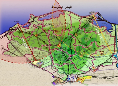
The following centers are located within the scope of Damietta Port: All centers within both the Dakahlia and Damietta Governorates, and each of the centers (Faqous - Abu Kabeer - Ibrahimia - Darb Najm) in Sharkia Governorate, and both centers (Aga - Samanoud Al-Mahalla Al-Kubra) in Gharbia Governorate, and centers (Hamol - Riyadh - Pella - Kafr El-Sheikh) in Kafr El-Sheikh Governorate, because they are located within 100 km from the port of Damietta. The rest of the Sharkia governorate centers (Zagazig - Minya El-Qamh - Belbeis) are included within the range, because Damietta's port is closer to it than any other port, so it is the most logical choice for transportation (Figure 16).
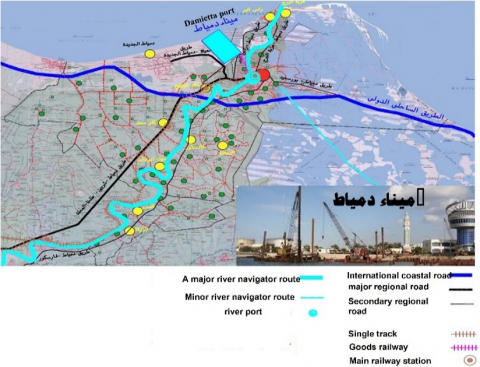
Multimodal: It means the possibility of using more than one type of transportation, such as two or more means.The port of Damietta is connected to a wide multimodal network that connects with the governorates of the Delta, the multi-modal is presented in three modes, first of all, the river transport by the Damietta branch through Damietta river port which is located inside the Damietta seaport in proximity to the grain terminal; secondly, the railways specialized in goods transport and linked to the port with a single line, as well as the highways where the international coastal road, in addintion to the Damietta-Egypt road (Damietta-Cairo highway), which connects Damietta with Kafr Saad, Sherbin, Talkha, and Mahalla...to Cairo (see Figure 17) [20, 21].
Figure 16. The scope of internal flow of Damietta Port
Figure 17. The multimodal of Damietta Port
Projects under implementation: On 3/28/2022, the Parliament Transport Committee approved a project to develop the Tanta-Mansoura-Damietta railway line, with a length of 119 km, linking the city of Tanta, which has a population of 700,000 people and is located 100 km north of Cairo, with the coastal city of Damietta on the Mediterranean coast, which has a population of one million and passes through Mansoura, which has a population of about 2 million people in the Nile Delta. The first part of the corridor between Tanta and Mansoura is a double-track line that is not electrified, while the second part between Mansoura and Damietta is a single-track line that is not electrified. Railway signaling has 2 sections including many junctions. Both sections support mixed passenger/goods traffic, with the first section using 56 trains per day (52 passengers, 4 freight), and the second with 32 trains per day (28 passengers and 4 freight) [22].
Rehabilitation and training of human resources: Damietta Port Authority obtained a grant from the European Union, to train 582 employees to work in seaports, and the duration of the project is 3 years. The project aims to improve the skills of employees and equip them with the necessary knowledge to handle the increasing demand for the port. The training will include courses on port operations, logistics, customs procedures, and marine regulations. Additionally, the project focuses on modernizing the port infrastructure and introducing modern technologies to increase efficiency. In the field of social participation, the Authority trained 350 trainees from young graduates, 750 university students [17].
Preserving the environment: The Damietta Port Authority used solar power plants to generate electric power in the port, and most of the cars in both the maritime transport sector and the Damietta Port Authority were converted to natural gas [17]. By doing so, the Damietta Port Authority was able to reduce its carbon footprint and reduce its reliance on fossil fuels. This is a crucial step in preserving the environment and combating climate change. The Damietta Port Authority has also implemented a variety of initiatives to reduce energy consumption, such as renewable energy sources, and energy efficiency measures. These initiatives have helped to reduce the environmental impact of the port and have set an example for other ports to follow.
Customs and fees: There is a customs department in Damietta Port run by the Central Customs Administration of Damietta. It follows the eastern region of the Customs Operations Sector of the Egyptian Customs Authority. About fees, there are many sections of fees paid at Damietta Port, for example, usufruct of land, use of the platform, cargo services, ship services, licenses granted to practice maritime transport work, providing specialized labor inside Damietta Port, Using the square meters in the investor complex, cleaning work [21].
Electronic connectivity to customs services: Damietta Port operates electronically and links all port services, such as customs and control of exports and imports, which enables these parties to exchange information related to the operations of transporting, loading, and unloading goods, and customs clearance of goods [17].
As a conclusion to this section, Damietta Port possesses comprehensive logistical capability as well as the ability to deal with goods and materials internally as well as externally through the use of a multimodal transport system. Moreover, the port is connected to an electronic network for customs clearance that enables customs clearance to be performed through one point of contact for all devices and sectors at the port. Aside from that, the state also rehabilitates and trains its human resources to be able to deal with problems efficiently. In addition, Damietta Port maintains a high level of environmental protection, uses renewable energy sources, and minimizes its carbon footprint as much as possible.
2.3 Evaluation of indicators
Indicators can be evaluated by grouping the three factors (level factors, function factors, and spatial factors) to form a comprehensive evaluation matrix. Accordingly, some examples that assess the logistic hub can be inferred, and they demonstrate that criteria can be collected by a matrix and given a rating to them [13]. The evaluation matrix can then be used to determine the efficiency of the logistic hub. If the results of the evaluation matrix are positive, the logistic hub can be considered a success and able to play a logistic hub role. If not, the logistic hub can be improved and specific the priority of development. This can be done by analyzing the results of the evaluation matrix and determining areas for improvement. This may involve additional training, resources, or infrastructure…etc.
The evaluation criteria for Damietta Port as a logistics hub can be deduced by mixing the previous criteria and the dimensions into a group of criteria.
First group-Level factors: The logistical level was determined by identifying the criteria through which the logistics facility's role is determined. This includes the extent to which interactions continue and to what extent flows can be applied by covering the geographical area. A group of 6 indicators is included in this group (Geographical coverage, modes and corridors of transport, third-party logistics services, government and commercial services, customs fees, and proximity to markets). Each of these six indicators assesses different aspects of the logistical process. Geographical coverage looks at the range of areas a facility covers. Transport modes and corridors examine the various types of transport used to reach specific areas. Third-party logistics services look at outside services, such as warehousing and delivery. Commercial and public services examine the presence of services that can be used for business or personal needs. Customs and fees assess the cost of doing business across different regions. Finally, proximity to the market is examined at the distance to the last or semi-final customer.
Second group-Function factors: Define the function and tasks of the logistic center and the availability of the elements for the success of this function. This group of criteria focuses on identifying the type of logistics facility. To complete logistic facility tasks and jobs. And a total of 5 indicators constitute this group (port capacity, supply of the required flows, labor supply, add value, level of technology). Port capacity determines the size of the facility and its ability to complete tasks. Labor supply and add value are also significant indicators, as they determine the availability of skilled labor. In addition, they determine the extent to which the facility can add value to the products. Finally, Level of Technology is critical to consider ensuring that the facility is equipped with the latest technology to trace the shipment and complete the tasks.
Third group-Spatial factors: Part of it depends on the previous criteria, whereby the availability of spatial requirements that provide the success of the function of the logistics facility itself on the one hand, and on the other hand, the spatial relations with the nodes, the different logistical destinations, and the type of transportation methods required to transfer the flow successfully. All these criteria are necessary to understand the complexity of the logistics system, as well as to understand the type of entanglements within the system. This group consists of 3 indicators (territorial relations, land availability, and government support for development). These indicators are necessary for understanding the system since they provide insight into the various types of relationships between different areas, the amount of land available for development, and the amount of support the government provides to the development of the logistics system. Table 10 shows the Evaluation of Damietta Port's performance indicators as a logistics hub.
Table 10. Evaluation of Damietta Port's performance indicators as a logistics hub
|
G |
The Indicator |
Measuring |
|
Level group |
Geographical coverage |
The international flow coverage to Damietta Port |
|
Transport Modes and Corridors (possibility territorial relations) |
The number of modes used by the port to transport flows |
|
|
The availability of tools that enable changing the type of transport from road to rail and vice versa |
||
|
Third Party Logistics Services |
Availability of shipping companies that act as an intermediary between the customer and the supplier |
|
|
Commercial and Public Services |
Availability of Public services on the site |
|
|
Customs and fees |
Availability of customs service and Appropriate amount of fees |
|
|
Proximity to market (internal flow) |
Proximity of residential areas |
|
|
Function group |
Port Capacity |
Shipment frequency and Storage capacity |
|
Providing the required flows |
Accessibility to supplying areas |
|
|
Labor Supply |
% Industrial labor and % Transportation labor |
|
|
Add value |
Providing value-added tasks |
|
|
Level of technology |
Ability to manage technology tasks and tracking shipments |
|
|
Spatial group |
Territorial relations |
Accessibility of urban logistic (nodes, cities, supplying areas, etc.) |
|
Land Availability |
Land available for development and re-development |
|
|
Government support of developments |
The Government project in the logistic field |
To achieve the main objective which is to test the ability of Damietta Port to play its role as a logistic hub by comprehensive multiple criteria. For creating valuable insights into its development and identifying the shortcomings that hinder it from being a logistics hub and prioritizing areas of development and improvement. The evaluation criteria consisted of three groups (function group - level group - spatial group).
Through the previous 14 indicators by 3 groups of criteria, it was concluded that Damietta Port can play a role as a logistical hub. Damietta Port is well-equipped to handle the logistics needs of the region and can provide efficient services to its users. The port is strategically located and connected to major transport networks, making it an ideal location for a logistics hub port. Table 11 shows the testing of the indicator.
Table 11. Assessment logistic hub by evaluation matrix
|
Criteria |
Rating |
Summary of Assesment |
|
INFRASTRUCTURE |
Excellent |
The N1 and N4 highways borders the site identified. Rail infrastructure is already in place, however a few adjustments will have to be made, but this will have to be addressed by Transnet Freight Rail. |
|
BASIC SERVICE |
Excellent |
Services such as water, electricity and sanitation are already in place |
|
ECONOMIC DEVELOPMENT/ ACTIVITIES |
Excellent |
International trade is an important driver for the city of Tshwane with tangible exports accounting for 45% and imports 22% of the city's GGP. |
|
TELECOMMUNICATION SYSTEMS |
Excellent |
This site, should it be developed to its full potential will give any company an excellent competitive advantage, and can be used to attract industry. |
|
WORKFORCE |
Good |
Informal settlements located in close proximity, has the potential to alleviate unemployment. Workforce has lower pay rates compared to other parts of the city. |
|
HIGHWAY ACCESS |
Excellent |
The N1 highway passes adjacent to the farm on the eastern side and joins the N4 highway south-east of the farm. The N1 creates north-south connection. The N4 highway runs south of the farm and gives direct access to the site via the K99 (Dr Swanepoel) interchange. |
|
ROAD AND BRIDGE CONDITIONS |
Good |
Potential for further bridge utilisation to the north of the farm. Roads around the farm are in well maintained by SANRAL. Sufficient road capacity available |
|
ROAD DENSITY AND CONGESTION |
Good |
Normal peak hour traffic is experienced, but is north of the renowned heavy congestion. |
|
PLANNED ROAD INFRASTRUCTURE |
Excellent |
The K99 extension has a direct impact on the logistics hub and is of cardinal importance to gain access to the site. The PWV 9 development which is key to the Maputo Corridor Development opens new opportunities. |
|
VEHICLE TAXES AND FARES |
Moderate - Good |
Both the N1- and N4 highways are toll roads. |
|
RAILROAD |
Good - Excellent |
Pyramid switchover yard is adjoining |
In relation to the first group: Level group, a total of six factors were evaluated, and four criteria indicated Damietta Port could serve as a logistic hub, while one factor indicated lack of ability. Finally, one factor indicated Conditionally able means the availability of capabilities, but its condition is intervention in development to improve shortages, so development intervention is important to complete the capabilities. By joining this group, the ability of Damietta Port was able to link with ports over a wide range, as well as have internal relations near markets available in the capitals of the governorates and major cities. It needs to increase commercial services and diversify land use by integrating commercial use despite these capabilities. Improving fees and reducing customs also requires quick intervention from the Egyptian government since it causes port users to dispense with Damietta Port’s services.
In relation to the second group: Functions group, a total of five factors were evaluated, and three criteria indicated Damietta Port could serve as a logistics hub, while two factors indicated quick development intervention to complete the capabilities. The group demonstrated the ability of Damietta Port through the availability of multimodal transportation, which relied largely on highways as well as railways. The workforce was also available from workers specialized in the transport and industry sectors, and the complementary industries in the port had a role in adding value to the petrochemical and grain industries. It is necessary for the government to intervene in developing the technological aspect of the port, which confirms the delivery and receipt process and provides logistical solutions when problems occur during trips.
Despite the decrease in the frequency of ships and the number of containers due to COVID-19 pandemic, which is considered a limitation, it has affected the ports of the whole world at the same pace and effect, and therefore its impact on Damietta Port alone is negligible.
In relation to the third group: the spatial group, a total of three factors were evaluated. All criteria indicated Damietta Port could serve as a logistic hub. The group demonstrated the ability of Damietta Port through its ability to provide broad urban connectivity to new cities, existing cities, and governorate capital cities. There is also land available for development and urban development, and the role of the Egyptian government is still effective in providing governmental support for logistical projects at the port.
Although Damietta Port ranks third among Egyptian ports with 23% of the total ship frequencies, it can be a logistic hub according to its strong logistical components.
Damietta Port has shortcomings, but they are limited and can be overcome and resolved through continuous government support.
Port operations must continue to adhere to a global approach to preserving the environment, reducing the carbon footprint, and reducing reliance on fossil fuels.
The importance of the research is crystallized in directing the Egyptian government and decision-makers to the shortages that need to be developed and improved in the port, such as: increasing public and commercial services, the necessity of increasing the technological role in the port, and providing smart logistical services, as well as reducing duties and reducing customs items, which include making it easier for investors and attracting the largest base of port users around the world, which helps attract foreign direct investment and develop and improve the economy.
The creation of urban connectivity between Damietta Port and new cities, existing cities, as well as the capital cities of the governorates, can help to support the preparation of strategic plans for the cities surrounding the port. Additionally, these plans should include measures to protect the natural environment and ensure sustainable economic growth.
The research faced the problem of insufficient information about the technological aspect of Damietta Port, and accordingly, it relied on the limited information contained in official reports, such as the Damietta city region report.
Despite its limitations, COVID-19 pandemic affected the ports of the whole world at the same pace and effects, and therefore its impact on Damietta Port alone is negligible.
The necessity of directing researchers' efforts towards urban logistics and shedding light on its various effects, especially on spatial relations and logistic territoriality. Future research could address logistics strategies from an urban perspective, evaluation of other types of logistics centers and the environmental impacts of port logistics hubs.
With various capabilities in terms of function, level, and spatial relations, the Damietta Port can play the role of logistics hub in the sense that it has a wide range of capabilities. Although there are some shortcomings concerning technology, customs, fees, and the lack of commercial services, all these issues can be addressed by directing the efforts of the Egyptian government and decision-makers towards addressing them. In this way, Damietta Port will be able to attract more direct foreign investments into the country, and as a result, the economy will be able to grow (Table 12).
Table 12. Testing the performance indicator for Damietta Port's
|
Measuring |
Testing |
Result |
|
The international flow coverage to Damietta Port |
1-Exports to seven international markets the volume of Egyptian exports to them reaches in 2020 nearly 27.42% 2-Export to the continents Europe, Africa, and Asia 3-The range of external flows reaches 3527 km |
Able to achieve level of hub |
|
The number of modes used by the port to transport flows |
3 modes (railway - heigh way - Nile River channel link with (a length 5.4 kilometers & width is 90 meters& depth up to five meters& design capacity is 19.75 million tons /year) |
Able to achieve level of hub |
|
The availability of tools that enable changing the type of transport from road to rail and vice versa |
96 handling points for refrigerator containers &10 rail-mounted cranes&10-yard cranes &all vertical loading cranes& forklifts and trailers. |
|
|
Availability of shipping companies that act as an intermediary between the customer and the supplier |
The 3pl services are available at Damietta Port between customers, agent, and shipping companies |
Able to achieve level of hub |
|
Availability of Public services on the site |
So limited that it is almost non-existent |
Unable |
|
Availability of customs service and Appropriate amount of fees |
(Usufruct of land, use of the platform, cargo services ship services, licenses granted to practice maritime transport work, providing specialized labor inside Damietta Port, Using the square meters in the investor complex, cleaning work |
Conditionally able |
|
Proximity to market (internal flow) |
35 km away from the farthest center of Damietta Governorate (Sherbin) 58 km away from Mansoura, the capital of Dakahlia Governorate 88 km away from Kafr El Sheikh, the capital of Kafr El Sheikh Governorate 100 km away from Tanta, the capital of Gharbia Governorate 105 km away from Zagazig, the capital of Sharkia Governorate |
Able to achieve level of hub |
|
Shipment frequency and Storage capacity |
Decreasing in 2021 compared to 2020 (8%), which is less than the average of the Republic (10%) |
Conditionally able |
|
Accessibility to supplying areas |
connected to the Delta by Heigh wayes and railways 1 - The international coastal road 2- The main regional roads (Damietta / Sherbin / Talkha / El-Mahalla El-Kubra Road, the Port Authority / New Damietta / International Coastal Road) 3- The secondary regional roads (Mansoura / Faraskour / Damietta Road, Damietta Road / the international road Diba, Damietta / Ezbet El-Burj Road, Damietta / Al-Jarbi / Ras El-Bar Road, Damietta / El-Sanania / Ras El-Bar Road (4- Railway Road (Cairo / Tanta / Mansoura / Damietta), (Mansoura / Damietta) |
Able to perform the function |
|
% Industrial labor and % Transportation labor |
1- There are 9 cities in which the percentage of workers in transport is high out of the total workers in economic activities (Tanta 7.56% - Mahalla 7.03% - Mansoura 6.71% - Mit Ghamr 4.14% - Sinbellaween 3.27% - Faqous 3.23% - Aja 3.11% - Sherbin 2.98% - Kafr El-Sheikh 2.91% A- There are 3 cities in which the percentage of workers in manufacturing industries is higher than 25% of the total workers in economic activities (Damietta 26.41% - Al-Mahalla 29.03% - Tanta 79.15%) B- There are 2 cities available from (10 to 25%) the percentage of workers in manufacturing industries out of the total Workers in economic activities (Mansoura 10.73% - Mit Ghamr 10.67%) C- There are 2 cities from (5 to 10%) The percentage of workers in manufacturing industries out of the total workers in economic activities (Kafr Saad 7.87% - Masmanoud 6.30%) |
Able to perform the function |
|
Providing value-added tasks |
added value industries related to grain and petrochemical in complementary areas |
Able to perform the function |
|
Ability to manage technology tasks and tracking shipments |
1- The percentage of the population according to the main occupations (% workers in scientific sector) in Damietta Governorate 24.7% of the total labor force 2-There isnt information about the ship tracking service |
Conditionally able |
|
Accessibility of urban logistic (nodes, cities, supplying areas, etc.) |
4 cities as a governorate capital (Tanta -Mansoura - Damietta - Kafr El-Sheikh) 1 new city (New Damietta) 28 dependent cities |
Able to create territorial net work |
|
Land available for development and re-development |
water surface area increasing 0.4 million m2&land surface area increasing 0.7 million m2 |
Able to create territorial net work |
|
The Government project in the logistic field |
Availability of government support such as: 1- Developing the railway system and signals 2- Developing Damietta Port (multi-purpose docks - commercial terminal - warehouses for storing goods - grain industries area - grain terminal - logistic area - the second container terminal - a multi-purpose terminal (Long live) Egypt 2) 3- Periodic development of roads |
Able to create territorial net work |
- As a result of this paper, it was possible to reach a conclusion regarding Damietta Port's ability to fulfill its role as a logistics hub, thereby providing us with a solution to the main question of the paper, which revolves around Damietta Port's ability to fulfill its role.
-It is clear that the results of this study are compatible with the literature. This can be attributed to the fact that when using the matrix table, it was possible to create an evaluation framework encompassing multiple dimensions and criteria that could be evaluated to reach the intended results.
- It has been proven that a comprehensive multi-criteria framework can be used to evaluate capabilities with different dimensions, and it is able to reach results, as shown in Botha's [14] study, where he compiled several criteria in a matrix and evaluated them to assess the seaport as a logistics hub based on a several criteria framework.
- Even though the COVID-19 pandemic decreased the frequency and number of ships and containers around the world, it has had the same effect throughout the world, and therefore Damietta Port alone had a negligible impact.
- The limitations that faced the research were the limited technological data on the port's capabilities.
- One of the very decisive conclusions is that the multi-criteria analysis led to the construction of a decision by which the port's capacity is assessed, and therefore the possibility of deploying urban development in the back of the port and its associated cities.
- This study presents the factors and criteria that affect the effectiveness and efficiency of the port as a logistic hub such as: infrastructure, land capacity for future extensions and added value... etc. Port operators, road operators, rail operators, and shippers were not discussed. However, the results showed that a port can serve as a logistic hub with various capabilities.
- This evaluation can be repeated for another Egyptian seaport since the application environment and its impact on the urban environment and development are similar.
- Damietta Port's logistics hub status will have developmental implications for roads and hubs in terms of urban planning and sustainable urban mobility. This is in cities surrounded by seaports. Therefore, this decision will support the master plans of the port cities and their development roles in regional planning. It will also support land uses development and provide new jobs and attract foreign direct investment, enabling it to eliminate unemployment and deal with economic and developmental issues in cities.
- The status of the Damietta logistics hub will impact the surrounding cities in the territorial area. These cities will benefit from improved infrastructure and increased job opportunities. This will achieve economic and social development and promote sustainable urban mobility, thus improving the quality of life for those cities' citizens.
- Furthermore, the environmental impact must be considered in future studies, including carbon dioxide emissions, noise, accidents, and congestion caused by road traffic.
- There could be future research on urban logistics strategies, evaluation of other types of logistics centers, the influence of multimodal operators on logistics hub efficiency, and environmental impacts of port logistics hubs.
- Damietta Port is able to play the role of a logistic hub from several directions and multi-criteria. We can call it a comprehensive framework.
- Directing development priorities to improve Damietta Port towards reducing customs and fees items, improving the technological aspect, and including commercial services within the port’s land uses.
- Necessity to update the regional strategic plan for the spatial scope of Damietta Port and city region plans in Damietta Governorate in light of its ability to be a logistics hub and urban connectivity.
- The necessity of providing entities that provide technological infrastructure information as well as digital information.
- The paper presents policymakers, urban planners and port operators with a comprehensive, multi-dimension and multi-criteria evaluation framework through which ports around the world, as well as various seaports in Egypt, are evaluated. Research on this topic is considered important.
- Damietta Port as a logistics hub can affect economic development through providing new jobs and attracting foreign direct investment, enabling it to eliminate unemployment and deal with economic and developmental issues in cities.
- The Egyptian government should develop specific strategies to reduce port fees and customs policy and determine them compared to the ports surrounding the Mediterranean Sea and emphasize the existence of a single window in which all procedures are facilitated
- Despite the efforts made, significant obstacles to the availability of technological data have emerged. As a result, adding more indicators in this aspect may improve the accuracy of the results. In addition to the pandemic that the world is facing due to COVID-19 pandemic, which has certainly affected all ports around the world's performance equally.
- In conclusion, the paper presented a comprehensive assessment framework and demonstrated the efficiency of the Damietta Port and its ability to play the role of a logistical hub in light of a set of standards and dimensions. There were some minor shortcomings, but they can be overcome by directing development policies to them. In light of this framework, it is necessary to exploit the port’s capabilities in urban development and social and economic development.
[1] Higgins, C.D. (2010). Varieties of logistics centres: Developing a standardized typology and hierarchy. Ph.d. Mcmaster University. https://doi.org/10.3141/2288-02
[2] Hamzeh, F.R., Tommelein, I.D., Ballard, G., Kaminsky, P. (2007). Logistics centers to support project-based production in the construction industry. In Proceedings of the 15th Annual Conference of the International Group for Lean Construction (IGLC 15), pp. 181-191. https://www.academia.edu/43657437/logistics_centers_to_support_project_based_production_in_the_construction_industry.
[3] Logistics centers directions for use, report by euro platforms eeig, january 2004 https://unece.org/dam/trans/main/eatl/docs/en-rev-what_is_a_freight_villagefinalcorretto.pdf
[4] Santos, A.G.D., Machado, R. (2020). Multiple-criteria analysis model to the location of dry ports in urban areas: A case study in Garuva City, Santa Catarina State. Urbe. Revista Brasileira de Gestão Urbana, 12. https://doi.org/10.1590/2175-3369.012.e20190302
[5] ESCAP, U.N. (2013). Guide to key issues in development of logistics policy. United nations economic and social commission for asia and the pacific, transport division. https://www.unescap.org/sites/default/files/logistics_policy_fulltext.pdf
[6] Nicolas, Frémont, D. (2013). Logistics sites - the joint dependence between networks and territories. (pdf) logistics sites - between networks and territories (researchgate.net)
[7] Bowersox, J., Closs, J., Cooper, B. (2019). Supply chain logistics management, Michigan State University. https://Industri.Fatek.Unpatti.Ac.Id/Wp-Content/Uploads/2019/03/259-Supply-Chain-Logistics-Management-Donald-J.-Bowersox-David-J.-Closs-M.-Bixby-Cooper-Edisi-1-2002.Pdf
[8] Brian, H. (2019). Connecting systems of secondary cities. Cities alliance. https://www.citiesalliance.org/sites/default/files/2019-07/ca_connectingsystems_web_final%20%281%29.pdf
[9] Pretorius. (2013). Logistical cities in peripheral areas, faculty of economic and management sciences. https://scholar.ufs.ac.za/bitstream/handle/11660/1928/pretoriusmp.pdf?sequence=1&isallowed=y
[10] Technical assistance for the implementation of logismed soft training actions, task 1.2 awareness session to public stakeholders, (October 2nd 2018), workshop on the conception and implementation of logistics platforms, Cairo.
[11] Du, J., Bergqvist, R. (2010). Developing a conceptual framework of international logistics centres. 12th WCTR, 1: 1-35. https://www.researchgate.net/publication/259079491_developing_a_conceptual_framework_of_international_logistics_centres
[12] Alam, S.A. (2013). Evaluation of the potential locations for logistics hubs: A case srudy for a logistics company. Degree Project in Transport and Location Analysis, Stockholm. http://www.diva-portal.org/smash/get/diva2:604876/fulltext01.pdf
[13] Botha, M., Ittmann, H.W. (2008). Logistic hubs: An integration of transport infrastructure. Pretoria, South Africa. https://repository.up.ac.za/bitstream/handle/2263/6255/Botha.pdf?sequen.
[14] NCFRP (REPORT 33). Improving freight system performance in metropolitan areas: A planning guide. https://www.academia.edu/19015911/NCFRP_Report_33_Improving_Freight_System_Performance_in_Metropolitan_Areas_A_Planning_Guide.
[15] Ekhsonov, J., Khoshimov, E. (2023). Establishment of transport logistics hub. International Journal of History and Political Since, https://www.researchgate.net/publication/375380077_ESTABLISHMENT_OF_TRANSPORT_LOGISTICS_HUB.
[16] Liebermann, D., Hoffmann, M. (2018). Logistics hub luxembourg, Ministry of Theeconomy. https://www.luxinnovation.lu/tradeandinvest/wp-content/uploads/sites/2/2018/01/Logistics-Hub_Luxembourg-PPT.pdf.
[17] Ministry of transport, maritime transport sector (mts), annual report 2021, march 2022 issue
[18] Ministry of housing - general authority for urban planning - study of the road and transport sectors for the Sadat Menouf conglomerate
[19] Ministry of trade and industry, information systems sector, central administration for statistics and reports, quarterly report, egyptian export trends 2020
[20] Ministry of housing, utilities and urban communities - the general authority urban planning - features of future planning for damietta governorate 2032
[21] Ministry of housing - general authority for urban planning - developmental features of the Damietta city region2021
[22] European Investment Bank. Tanta-El Mansoura-Damietta Railway Upgrading Project. https://www.eib.org/en/projects/all/20180764.