Sophia Rezaq Ali Al-Timimy*![]() | Baydaa Abdul Hussein Bedewy
| Baydaa Abdul Hussein Bedewy![]()
© 2023 IIETA. This article is published by IIETA and is licensed under the CC BY 4.0 license (http://creativecommons.org/licenses/by/4.0/).
OPEN ACCESS
Various countries of the world endeavor to achieve a new paradigm of sustainability by preserving their heritage and history and avoid the risk of old process preservation. Therefore, this article adopts several concepts for investigating heritage areas and then builds a model based on spatial analysis using GIS. So, the main problem this article addresses is that planning does not rely on appropriate mechanisms for preserving the heritage area of Al-Nasiriyah in Dhi-Qar Governorate, Iraq, which has resulted in erosion and destruction of that area. Consequently, the article aims to determine the optimal process for the rehabilitation to the heritage city center, using spatial analysis mechanisms and to achieve urban sustainability. To do this, the article first discusses various countries' experiences in the field of heritage conservation to understand successful principles for implementing the new sustainable paradigm. Subsequently, the Analytical Hierarchy Process (AHP) is used to calibrate and assign weights to the analysis mechanism. This process is based on the most prominent elements that depend on land uses and necessary services in the spatial analysis. After analyzing eight indicators, a consistency ratio of 0.47 was obtained, which is the acceptable excitation range in AHP standards. Finally, the study built a model in GIS to determine the most suitable area for the development of any city with the same condition. Therefore, the spatial analysis and model process identified Zones 2 and 3 as the most suitable for development, with Zone 4 being the optimal choice according to the MCDM analysis to be selected as the first area for development. Thus, this can limit the process of erosion of the urban heritage fabric due to the encroachment of commercial use and the rise in the value of achieving cultural sustainability.
urban sustainability, (AHP) analytical hierarchy process, (MCDM) multi-criteria decision making, spatial analysis, heritage city center, rehabilitation process
Our world and the way we live are fundamentally shaped by what has come before and the decisions made about how to manage it [1, 2]. Accordingly, cities and communities are socially and culturally constructed places. Therefore, culture is a creative expression that is embodied and reflected in physical forms and locations as a result, of the living patterns that occur there, and the innovations and creative forms that those environments provide [3-5].
Whether heritage is, tangible or intangible culture: represents the diversity of social history [6].
Whereas, all structures of cultural importance and the city site can be categorized as buildings' heritage [7, 8].
Likewise, Leitmann discusses that each heritage position provided a frame to the five senses of position, that is: ancient construction in addition to environment that generated the affiliation to the location and constitute the cultural identity and ancient relations [9, 10].Although many studies have shown culture as a fourth pillar of sustainability, the emergence of culture within the concept of sustainability was included for the first time on the international agenda for sustainable development, as part of the development goals adopted by the United Nations in 2015 [11-13].
Interestingly, in 2016 it was the urban sustainable development of cities within the “New Urban Agenda” in “Habitat III”, the United Nations Conference on Housing and Sustainable Urban Development (Ecuador, 2016), the Conference (Bogota, 2016), and the Association of United Cities and Local Governments. UCLG launched a Global Agenda for Local and Regional Governments for the 21st Century.” It also supported projects implemented for various cities around science through the Millennium Development Goals Achievement Fund to fulfil the role of culture as an engine of urban development through the “National Culture 2016” campaign [14, 15].
So, to balance the cultural heritage and modern cultural production, different cultural models, global and local influences, in urban environment can identify in phrases urban sustainability [16]. Both material and immaterial well-being, dynamic efficacy and intergenerational equality, rights to intergenerational equality, diversity preservation, the precautionary principle, cultural system maintenance, and recognition of interdependence [17].
They are together considered criteria for achieving sustainability in its new concept, which must be planned and managed in a way that guarantees the share of future generations in obtaining inherited cultural diversity [14, 18].
Therefore, failure to preserve heritage, misunderstanding of our history, and determining how to deal with our cities today and their heritage sites undermine the share of future generations in obtaining their inheritance and robs future cities of their right to historical communication. Sustaining them with a new concept requires managing the past, and sets limits on how to live in them in the future [19, 20].
The article's hypothesis is: Al-Nasiriyah Heritage City Center (if appropriate conservation process) can provide economic and social returns for the current and future generations towards the new concept of sustainability.
The problem addressed in the article is that traditional preservation policies need to be revised to protect the heritage center of the city from loss and erosion. Also, it cannot effectively contribute to achieving sustainable development.
Therefore, the article aims to support the decision-maker by Analysis of heritage site advantage of spatial analysis mechanisms in (GIS) and AHP, (MCDM).
The rehabilitation of the heritage area is through comparison between the mechanisms for preserving archaeological areas in the experiences of different countries.
Achieve sustainability in its new sense preserves the city’s cultural identity and cultural heritage, and achieves fairness and equality.
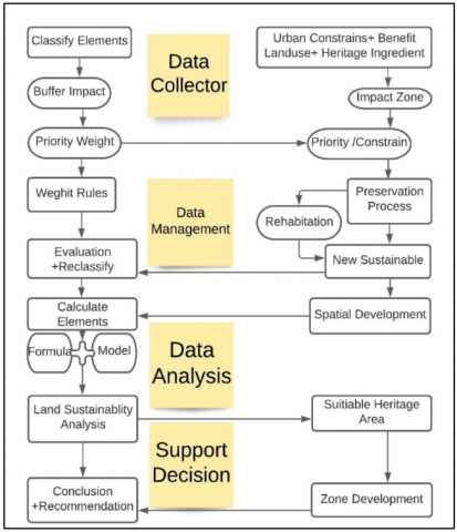
The methodology of the article is presented through three main stages adopted to implement the proposed method. The first stage reviews previous studies, discusses the most important operations to preserve the heritage site, and choose the most important operations that are appropriate for the city.
The second stage is surveying all land uses in the center of the heritage city and reviews the relevant departments such as the Urban Planning Department to collect the necessary information.
Figure 1. Methodology of article
The third stage of analysis includes:
Step (1): Draws the area using ArcGIS layers.
Step (2): Identifies the uses that attracted development, such as services and heritage buildings the limitation elements such as roads and river on the site.
Step (3): Analysis using AHP and giving weights to indicators affecting development.
Step (4): Spatial analysis based on weights using geographic information systems.
Step (5): Analyses the results to obtain the best development plan compatible with operations in the first stage of achieving sustainability (Figure 1).
The research addresses two concepts: mechanisms for preserving archaeological areas and sustainability. Therefore, it has become necessary to review previous studies and experiences to choose the best policy that suits the mechanism of preservation and achieving sustainability in its new concept as bellow:
3.1 Countries experiences in preserving heritage until emergence the concept of sustainability
Many countries have paid attention to cultural heritage preserving the continuity of heritage is a unique and vital component of the city [21]. New Zealand is one of the pioneering countries in this regard, as it included the local culture in the planning process of the 1991 local government act [22]. Subsequently, the local government law was incorporated in 2002, emphasizing a democratic framework, immediate local decision-making, and the preservation of local heritage. Consequently, the local community’s culture became one of the elements of sustainability within the local government law [23]. Similarly, in the United Kingdom, in the year 2000, the creation of a law establishes the overall strategic orientation and long-term goals for the community's environmental, social, and economic well-being [22].
By 2015, sustainability in the UK encompassed social, economic, environmental, and cultural aspects, establishing cultural sustainability as the fourth pillar widely adopted in international policies, particularly in European cities [24].
Additionally, the Government of Canada implemented the Federal Sustainable Development Act, recognizing the contribution of Canadian heritage to all pillars of sustainability within the country. This act was put in place in December 2019 [25]. Then, the United Nations' 2030 Agenda in 2015 highlighted the importance of protecting heritage as goals for the new concept of sustainable cities, which can be seen in the Sustainable Development Goals (SDGs) [26]. For all that, the heritage important became the fourth pillar to sustainability [27].
3.2 Countries' experience in investigate and package heritage place
In this context, we will discuss the essential measures for investment in heritage areas to promote the sustainable development of cities. Many countries recognize the significance of preserving and investment in their heritage, not only for financial reasons but also to safeguard their cultural heritage and uphold their historical identity [28]. In this process, buildings, cities or all entire countries have been remapped initiatives to serve cultural, economic and scholarly goals [29, 30].
The pursuit of preserving heritage can be traced back to the nineteenth century when Steward examined how Italian sites were depicted to represent Europe and maintain social identities by portraying them as "The cities of the soul" [31]. Similarly, Hurtt explored the regional Center, constructed for the 1937 Paris International Exhibition, which aimed to promote provincial tourism during an economic depression. The centre’s success led to France's continued definition of regions until today [32]. An interesting case study is the remapping of Old Havana, which underwent a transformative process following a devastating fire. Under the guidance of city historian Eusebio Leal, the city was revitalized into an appealing historic center that now serves as a leading catalyst for economic development in numerous cities. Additionally, the revenue was generated from tourism supports healthcare, education, and housing for the local population [32]. Many countries have gradually directed their preservation efforts towards heritage cities and investment in it, including Cuba, Ghana, Greece, Mauritius, and Spain, spanning from the renaissance to the present [34]. Preserving heritage processes plays a crucial role in maintaining a sense of identity, as demonstrated in France, where the development of attractive historic centers has become a primary economic strategy for cities [35]. For all that, the preserving process is to keep heritage identity and development the city center. So, the article shed light on sustainable development to deal with heritage center.
3.3 Heritage area development policy
Each place has unique characteristics that distinguish it as a heritage site. Heritage places evoke a sense of belonging through their historic buildings, cultural traditions and continuity of historical identity. Preserving and promoting heritage can contribute to sustainable cultural development and keep it from being lost forever [36]. Various approaches can be used in conservation, including many processes of site conservation that should be separated from process that deal with isolated building and may unity with [37-39]:
Conservation process: All tasks associated with the protection and maintenance of historical and archaeological resources are classified as conservation work. Whether they are structures or urban landscapes, they must be protected, developed, managed and repaired in order to highlight their importance [40, 41].
Redevelopment includes rebuilding a ruined region or reconstructing a deteriorated heritage area. This approach involves the removal of the majority of the area subject to urban renewal, or the whole fabric, reconsidering the existing land uses and distribution pattern. This strategy entails reevaluating the current land usage and distribution pattern as well as demolishing old structures and reconstructing them in accordance with current social and economic demands [42].
Infill urban to heritage sites: It represents that contemporary architecture that can be integrated into ancient weaving fabric sites, which can bring harmony into the urban plan that can accept the current fabric as the basis for its future development. In order to achieve harmony between a modern structure and its historic surroundings, primarily formal-composition indicate (mass, appearance, volume, pattern, and aesthetic) were developed [43].
Revitalization: It is aimed to either return the area or historic structure to its previous state or to revive the activities that led to the development of the area or historic building. Revitalization could involve denotes the presence of some modifications that would transform the structure in a way that might allow it to accommodate the development that dependent on the nature of the new action [43-45].
The concept of rehabilitation plays an important role in preserving the comprehensive heritage and protecting it from the problems of the traditional processes referred to earlier. Morton defines rehabilitation as a process that enables the use of specific heritage sites through various methods to enhance their preservation and transfer their value to future generations [45]. Therefore, the rehabilitation policy includes all the processes required to achieve heritage development for the benefit of the local community [25]. In our research, we will use the rehabilitation policy to develop old city centers in line with contemporary requirements, introducing a renewed center that restores the importance of these historical entities and preserves the city's heritage from being lost and achieve a new sustainable concept.
4.1 The study area
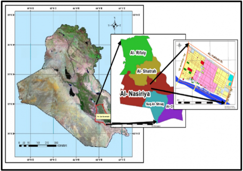
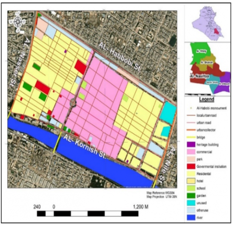
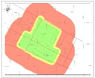
The coordinates (46ᵒ 4´ 40″, 31ᵒ 03´ 20″) – (46ᵒ 16´ 10″, 31ᵒ 02´ 10″) encompass the city of Al-Nasiriyah, which is situated in Thi-Qar, southern Iraq [46]. Al-Nasiriyah has a historical center dating back to 1869 AD, as depicted in Figure 2. It serves as the capital of the Thi-Qar governorate and is located approximately 370 kilometers southeast of Baghdad. The city is home to around two million people and covers about 12,900 square kilometers. That proximity to other ancient cities and towns, including the renowned ancient city of ancient Ur city and the archaeological region of the Thi-Qar Governorate's marshlands, adds to its significance [12], see Figure 3.
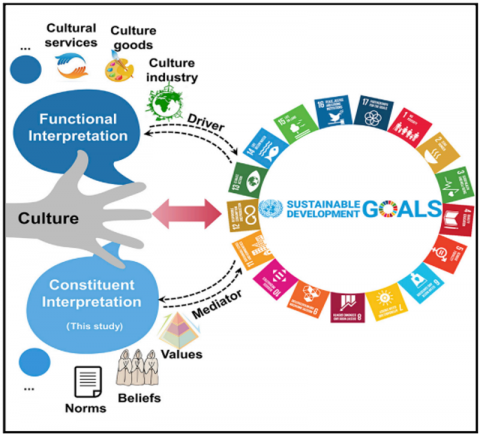
Figure 2. The culture as one of sustainable goals and links all pillars to each other in sustainable [47]
Figure 3. The ancient center in Al-Nasiriyah in Thi-Qar governorate
4.2 Historical periods of the city
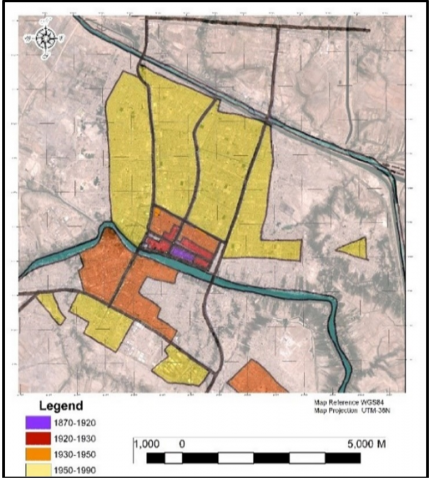
By rediscovering the characteristics of the spatial and morphological distribution of location, it is necessary to locate numerous factors to rearrange urban spaces while analyzing the urban centers of ancient cities. Prompted us to study the descriptive ancient city where the ancient city was planned within a network pattern, and the main road was previously called Aqed Al-Hawa, then Al-Habbobi was named after the martyr Muhammad Saeed al-Habbobi, whose statue is one of the most important landmarks in the center of the city. This ancient zone is the city’s core and features several monumental buildings, such as Mrs Landa Mosque, Mandaien District, and Mandaien's Temple.
Figure 4. The ancient city zones from the historical center concerning of the city, AL-Nasiriyah City Development Strategy, 2011
Note: The strategy of the city centre of Al-Nasiriya Master plan Strategy of Development and update.
These structures, along with many other facilities, retain their archaeological and architectural significance and require rehabilitation and preservation as they represent the local heritage of the city, known as "Domestic Culture." Consequently, the development strategy of Al-Nasiriyah City in 2011 designated this zone for conservation treatment. Additionally, the city is situated in close proximity to the ancient city of Ur, approximately 17 kilometers away, which holds significance as a center for Christian pilgrimage and that visited by the Pope in 2021. Al-Nasiriyah is also surrounded by numerous ancient cities, towns, and settlements, enhancing its spatial integration, particularly due to its proximity to archaeological communities in the marshes of the Thi-Qar Governorate [12] (Figure 4).
So that will ensure the problem of article as neglected central heritage part of the city leads commercial use to encroach upon important zone, and conservation process alone can't represent sustainable development in that case.
4.3 GIS and Support Decision- Maker
Spatial analysis is an important strategy for promoting sustainable development in urban planning and avoiding risks to the economy and environment [48]. As a result, much quantitative and criterion information is required to evaluate the spatial analysis of land [49].
Analytical Hierarchy Process (AHP): is one of the techniques to calculate weight, in the context of the decision-making process [50].
In this method the weighting values depend on the capabilities and determinants as criteria by using the geometric mean, the process is on a scale of 1-9 by comparison between each pair of criteria, then the values are solved by matrix. The consistency which must be more than 0.1 is measured by consistency ratio (CR) [51].
The MCDM technique is frequently utilized in engineering, economics, and administration of the environment, to handle complicated, conflicting, multi-objective situations. It seeks to offer a methodical methodology for decision-makers from [52]:
Identify the options, standards, and goals first. Assess alternatives evaluated utilizing values. Establish the weighted priority for every single criterion. In this stage, stakeholders or decision-makers are asked about their preferences, and all evaluation numbers for all alternatives generate an overall value. Eventually, Choose the best alternative [53, 54].
Here are several MCDM approaches and techniques available such as: Analytic Hierarchy Process (AHP), TOPSIS (Technique for Order of Preference by Similarity to Ideal Solution), Analytic Network Process (ANP), Simple Additive Weighting (SAW), Weighted Sum Model (WSM) [54, 55].
Therefore, selected AHP in MCDM because it is one of the best ways to find the optimal solution for decision-makers that will be used in this article to rehabilitate the appropriate heritage area using spatial analysis [55].
While, SOWT is the systematic technique used to evaluate strengths and weaknesses, opportunities, and threats while monitoring the internal and external environment. This offers a fact-based and data-driven perspective on planning decisions and actions, as well as a strong foundation for deciding the strategy, Which MCDM can adopted to assist in the selection of objects in spatial analysis and optimal option choosing.
4.4 Spatial analysis and building model
The processer to build a model in this paper is as below:
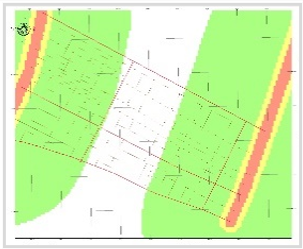
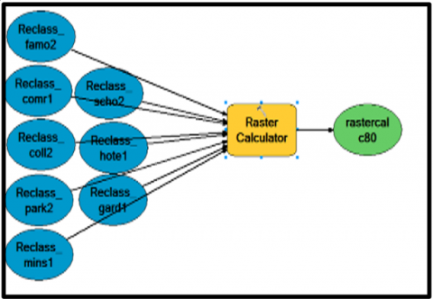
1. Building Geodatabase collect data and satellite images, as in Figure 5.
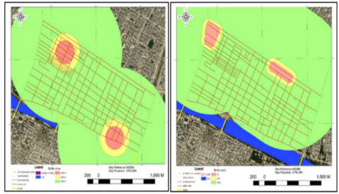
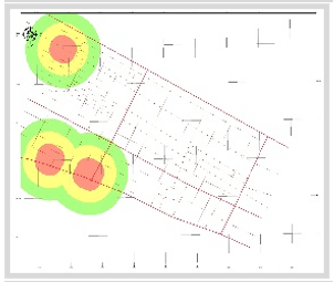
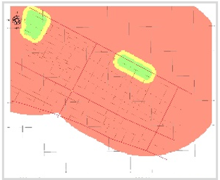
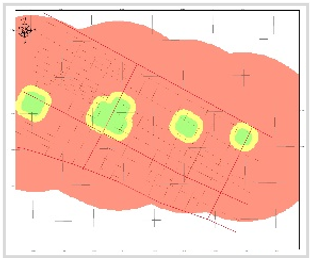
2. Build buffer zone to eight potentialities and constraints. As example from Figure 6.
Figure 5. The city center, the most prominent streets and land use, as well the location from Iraq, and Governorate, ArcMap 10.4.1
Figure 6. (a) Ring around ancient building; (b) Ring around parking, ArcMap 10.4.1
The red, yellow, and green showing three rings from object to the end of the area to development.
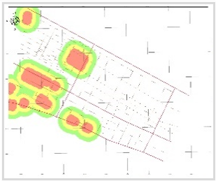
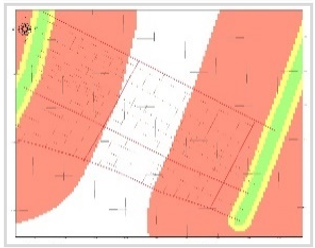
4.5 Reclassify
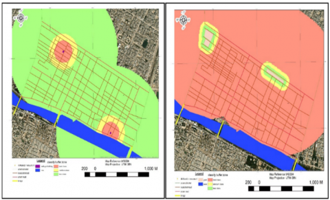
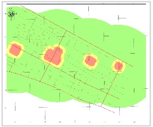
Reclassify the zone's color of potentiality and constraints (the red zone represents the zone with the best potentiality and is closest to the feature, the yellow is middle, and the green zone is the lowest one in potentiality. But for the constraints,
The case will be in reverse [55]. As in Eq. (1):
$X i=x i d j$ (1)
where, Xi=reclassify xi (dj), dj=the distance from article obtain by (buffer rings A, B, C) (z).
Two figures are shown three rings after reclassifying from object to the end of the area to development heritage zone the best near the object and so on another potential, but in the parking zone, the best is far away from the object, as well as other constrain.
4.6 Spatial analysis calculations
The study area was characterized by the elements of the structure behaviour through Zone Anatomy spatial analysis of the study area using geographic information systems, in Table 1 and using the following equation:
Table 1. Potential and determinate of development to Figure 7
|
No. |
Potential (Weights) |
No. |
Constraint (Weights) |
|
1 |
Near to famous heritage building (famo) |
1 |
Far from administrative areas (mins) |
|
2 |
Near to green areas (garden) |
2 |
Far from commercial use (comer) |
|
3 |
Near to hotel (hotel) |
3 |
Far from collector road (coll) |
|
|
|
4 |
Far from the car parking (park) |
|
|
|
5 |
Far from the school (school) |
|
∑ all weights =100% |
|||
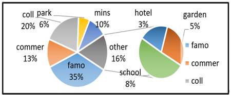
where, 1: extremely importance 3: very strong importance 5: strong importance 7: moderate importance 9: importance (other number is in-between) as well as the table contain all summarize of all elements. As shown in Table 2.
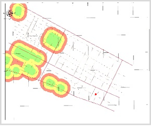
Figure 7. a) Buffer zone of heritage building; b) buffer zone of parking, ArcMap 10.4.1
As well as: (famo): mean near to famous heritage building, (garden): mean near to green areas, (hotel): mean near to hotel, (mins): mean far from administrative areas, (comer): mean far from commercial use, (coll): mean far from collector road, (park): mean far from the car parking, (school): mean far from the school. That all summation weights equal 100%, As in Table 3.
where, all summarize are the same in Tables 1, 3 and 4.
Table 2. Explain the result of analysis AHP as a priority and rank of weight for spatial analysis
|
Elements |
Buffer Zone |
Reclassify Buffer Zone |
|
Near famous heritage building |
||
|
Near green areas |
||
|
Near to hotel |
||
|
Far from administrative areas |
||
|
Far from commercial use |
||
|
Far from collector road |
||
|
Far from car parking |
||
|
Far from the school |
||
Table 3. Explain the potential numbers in AHP that, after analysis, give priority and assign weight rankings for spatial analysis
|
|
Famo |
Comer |
Coll |
Park |
Mins |
School |
Hotel |
Garden |
|
|
1 |
famo |
1.00 |
6.00 |
2.00 |
4.00 |
4.00 |
3.00 |
7.00 |
6.00 |
|
2 |
commer |
0.17 |
1.00 |
0.50 |
3.00 |
3.00 |
1.00 |
3.00 |
3.00 |
|
3 |
coll |
0.50 |
2.00 |
1.00 |
3.00 |
2.00 |
4.00 |
5.00 |
3.00 |
|
4 |
park |
0.25 |
0.33 |
0.33 |
1.00 |
0.50 |
0.50 |
2.00 |
2.00 |
|
5 |
mins |
0.25 |
0.33 |
0.50 |
2.00 |
1.00 |
2.00 |
4.00 |
2.00 |
|
6 |
school |
0.33 |
1 |
0.25 |
2.00 |
0.5 |
1.00 |
2.00 |
2.00 |
|
7 |
hotel |
0.14 |
0.33 |
0.20 |
0.50 |
0.25 |
0.5 |
1.00 |
0.50 |
|
8 |
garden |
0.33 |
0.33 |
0.5 |
0.50 |
0.50 |
0.50 |
2.00 |
1.00 |
Table 4. AHP for rank
|
|
Elements |
Priority |
Rank |
|
1 |
famo |
34.7 |
1 |
|
2 |
commer |
13 |
3 |
|
3 |
coll |
19.6 |
2 |
|
4 |
park |
6 |
6 |
|
5 |
mins |
10 |
4 |
|
6 |
school |
8.4 |
5 |
|
7 |
hotel |
3.4 |
8 |
|
8 |
garden |
4.8 |
7 |
4.7 SOWT technique
To explain the internal and external environment we evaluate strengths and weaknesses, opportunities, and threats, in Table 5.
Table 5. Strengths, weaknesses, opportunities, threats
|
Strengths Efficient resource use and secure investment in cultural heritage. Protecting cultural treasures and minimizing their degradation. Improving the environment for culture. Boost infrastructure strength. An increasing percentage of tourists. Create additional employment possibilities, particularly for locals. |
|
Weaknesses Inadequate comprehension of the significance of city heritage. Inadequate knowledge and experience to invest in cultural heritage. The population's ineffective involvement. For heritage tourism, the infrastructure is unsuitable. |
|
Opportunities Entice capital and investment. Bolster the population's identity. Infrastructural improvement. A growing number of tourists. |
|
Threats There is little administrative and legal competence as well as no national or regional support. Interest in urbanization, the trend toward globalization, and lack of interest in heritage. Economic pressures on heritage property owners increased the value of the land. Entrepreneurs' lack of commitment to funding and investing in urban heritage. Lack of legislation and laws to limit the destruction of inherited fabric. |
Consistency Ration (CR) is Consistency Index (C.I) over Random Index (RI) [54]:
$\mathrm{CR}=\frac{C I}{R I}$ (2)
where, Elgen value λmax=8.788 from AHP program analysis, n= 8 index, Random Index (RI)=1.41 as eight index:
$\mathrm{CI}=\frac{\lambda \max -n}{(n-1)}$ (3)
Then Consistency Ration (CR) = 8% that will less than 0.1 (CR> 0.1) then the weight numbers accepted and accepted decision get form AHP analysis.
Of course, the development in (potential column and Constraint of Table 1 for that the Rank sum builds as a model of spatial analysis in Figure 8.
When group rank-sum weights for each criterion are calculated as follows:
Weighting of factors:
Wfamo=0.35, Wcomme=0.13Wcoll=0.2, Wpark=0.6,
Wmins=0.1, Wschool=0.8, Whotel =0.03, Wgarden=0.05
where, all summarize as same in Table 2.
After applied classification in equation 1 so the equation of analysis Eq. (2):
$\left.S=\sum_i^n [W_i X_i\right]$ (4)
where, $W_i X_i: i^{\text {th }}$ feature weight, $i^{\text {th }}$ : criterion score, respectively [55]. As Eq. (5):
$\begin{aligned} \text { Wi }=\text { Wfamo }+ & \text { Wgarden }+ \text { Whotel }+ \text { Wmins } \\ & + \text { Wcommer }+ \text { Wcoll } \\ & + \text { Wpark }+ \text { Wschool }\end{aligned}$ (5)
Influence distance is made in that case by dependent on the relative intensity (e.g., era, quality, and rating) value of the target feature.
where, all summarize are the same in Table1. Where AHP give results for all elements that reclassify as figures in Table 3.
Figure 8. AHP for rank (Table 4)
Figure 9. Build model to spatial analysis to Potential and Constraint, ArcMap 10.4.1
Where modelling work as all element after reclassify can calculate in Eq. (5) to equal spatial analysis of the heritage area.
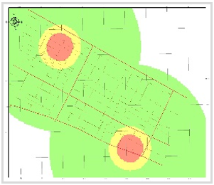
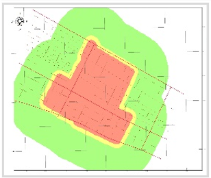
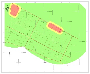
The resulting Figure 10 from the modelling in Figure 9.
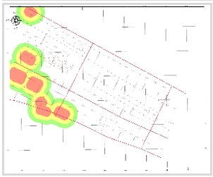
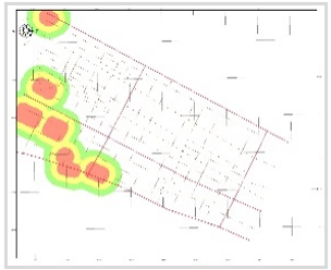
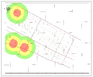
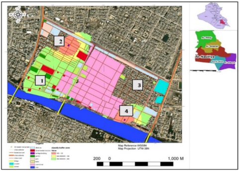
Figure 10. The result of modelling in GIS is presented as three color zones: red indicating the best class of development, yellow indicating medium, and green indicating the least developed class
As a result figure from modelling in Figure 9, the colors in Figure 10 represent the results of the spatial analysis from the geographic information systems, derived from the weights of the AHP method. From the four zones, it is shown that: the red color, which represents the best areas of development, which result from the abundance of potential and attractive elements with the highest weight, has the highest percentages in areas (zone 1) and (zone 4). The best area for development is then selected, represented by area (zone 4), because it features most of the objects in MCDM. In addition to its proximity to the river and its cohesive heritage fabric, it also includes the Sabian-Mandaean Temple and the Sabian zone. These represent a unique legacy of the Sabian sect, symbolizing pluralism in the city and recognition of other cultures. They are still in good condition, qualifying them for investment and helping to limit the destruction of their fabric due to rapid commercial encroachment.
Then (zone 1), can be chosen to be the second development area in terms of importance, as it ranges within the spatial analysis from red, yellow, and green, that is, from best to least for development, as it contains, Mrs. Landa’s Mosque, was built by a rich Christian woman, who chose to live in Al-Nasiriyah Because of her love for the generosity of city people and her love for the poetry they excel with.
While (zone 3) does not represent the best development areas. Also, in pink color where that in high price and can't invest in the rehabilitation process, besides that, a large number of commercial buildings destroy its heritage fabric. So, spatial analysis can help the decision-maker in the city by choosing the appropriate area for sustainable heritage in the city.
The preservation process used in many heritage sites alone cannot represent sustainability. Achieving sustainability with a new paradigm requires the rehabilitation of the heritage centre and preservation local culture.
That can also have value for the welfare of the communities living in these areas and raise the quality of their lives. It was not easy to choose which section can be developed in Al- Nassiria city center. The section is closest in terms of potential, as well as heritage important and sensitivity. In that case, the importance of spatial analysis appears to supported the decision maker. To establish a new sustainable paradigm, it is necessary to engage rehabilitation of the city's heritage centre and the preservation local culture. This approach contributes to the welfare of the area's communities and enhances their quality of life. So, this article suggests relying on rehabilitation to develop suitable areas as part of the new sustainable paradigm. This approach aims to protect and invest invaluable archaeological areas from Al-Nasiriyah centre, as their loss would be irreplaceable. When faced with multiple groups of interests and conflicting goals, the appropriate section for development was chosen. In such cases, spatial analysis is vital in supporting decision-makers integrated with MCDM by providing valuable insights and guidance.
Determinants and recommendations for future work:
The research suggests developing a plan based on this model based on indicators and determinants derived from the field survey according to the nature of the heritage city, to form a future plan. This plan to preserve its heritage, identity of its community, and achieve urban sustainability. In addition, it achieves an integrated development plan with nearby archaeological cities, which leads to tourist attraction and gives an image of the historical development that the region has undergone.
[1] Chapman, E., Rogers, L., Kay, A. (2021). Toward just and sustainable cities: Identifying key areas for urban, peri-urban and rural sustainability collaborative initiatives. International Journal of Environmental Impacts, 4(1): 36-48. https://doi.org/10.2495/EI-V4-N1-36-48
[2] Waheed, Z.A., Humaidi, A.J., Sadiq, M.E., Al-Qassar, A.A., Hasan, A.F., Al-Dujaili, A.Q., Abbas, S.J. (2023). Control of elbow rehabilitation system based on optimal-tuned backstepping sliding mode controller. Journal of Engineering Science and Technology, 18(1): 584-603.
[3] Naheed, S., Shooshtarian, S. (2022). The role of cultural heritage in promoting urban sustainability: A brief review. Land, 11(9): 1508. https://doi.org/10.3390/land11091508
[4] Al-Saffar, M. (2018). Urban heritage and conservation in the historic centre of Baghdad. Journal of Heritage Architecture, 2(1): 23-36. https://doi.org/10.2495/HA-V2-N1-23-36
[5] Carneiro, P.D.S., Pereira, A.R., Mira da Silva, M. (2023). A model for the deployment of shared autonomous vehicles in urban areas based on the research literature. International Journal of Transport Development and Integration, 7(3): 199-213. https://doi.org/10.18280/ijtdi.070304
[6] Bedewy, B.A., Abdul-Ameer, H.N., Al-Timimy, S.R., Abdulameer, M.H. (2023). Processing traffic jam in al-sadrain intersection in the holy city of Najaf. In E3S Web of Conferences, 427: 03021. https://doi.org/10.1051/e3sconf/202342703021
[7] Mu, J., Wang, T., Zhang, Z. (2022). Research on the acoustic environment of heritage buildings: A systematic review. Buildings, 12(11): 1963. https://doi.org/10.3390/buildings12111963
[8] Harrison, R. (2010). What is heritage? In Understanding the Politics of Heritage, pp. 5-42.
[9] Leitmann, J.L. (1999). Sustaining Cities: Environmental Planning and Management in Urban Design. Publisher: McGraw–Hill Professional Publishing.
[10] Navapan, N., Oonprai, K. (2019). Integration of historic places in new urban development: A case study of Phitsanulok, Thailand. Geographia Technica, 14: 22-31. http://doi.org/10.21163/GT_2019.141.15
[11] Verina, N., Astike, K., Grybaite, V., Budanceva, J. (2021). Culture as a driver of sustainable development in Europe. Economics and Culture, 18(2): 73-82. https://doi.org/10.2478/jec-2021-0016
[12] Ahmed, M.G., Gawad, M.A. (2022). Architecture sustainability and energy efficiency. International Journal of Energy Production and Management, 7(3): 257-264. https://doi.org/10.2495/EQ-V7-N3-257-264
[13] Bedewy, B.A.H., Al-Timimy, S.R.A. (2023). Multivariate spatial parameters analysis for estimate essentially fuel station location in Al-Mahaweel City toward urban sustainability. International Journal of Transport Development and Integration, 7(3): 247-255. https://doi.org/10.18280/ijtdi.070308
[14] Sabatini, F. (2019). Culture as fourth pillar of sustainable development: Perspectives for integration, paradigms of action. European Journal of Sustainable Development, 8(3): 31-31. https://doi.org/10.14207/ejsd.2019.v8n3p31
[15] UN General Assembly. (2015). Transforming Our World: The 2030 Agenda for Sustainable Development. UN General Assembly: New York, NY, USA.
[16] Puchol-Salort, P., O’Keeffe, J., van Reeuwijk, M., Mijic, A. (2021). An urban planning sustainability framework: Systems approach to blue green urban design. Sustainable Cities and Society, 66: 102677. https://doi.org/10.1016/j.scs.2020.102677
[17] Vila, S.F., Miotto, G., Rodríguez, J.R. (2021). Cultural sustainability and the SDGs: Strategies and priorities in the European union countries. European Journal of Sustainable Development, 10(2): 73-73. https://doi.org/10.14207/ejsd.2021.v10n2p73
[18] Ibraheem, I.F., Al-Hadithi, M. (2022). Remote sensing utilization for the modelling of land surface temperature for sustainable city development. Open Access Repository, 8(7): 95-106. https://doi.org/10.17605/OSF.IO/3AVNW
[19] Belal, A., Shcherbina, E. (2021). Post-war planning for urban cultural heritage recovery. In E3S Web of Conferences, 263: 05054. https://doi.org/10.1051/e3sconf/202126305054
[20] Benhamou, F. (2020). Handbook of Cultural Economics. 3rd ed. Publisher: Edward Elgar Publishing.
[21] Zheng, X., Wang, R., Hoekstra, A.Y., Krol, M.S., Zhang, Y., Guo, K., Wang, C. (2021). Consideration of culture is vital if we are to achieve the sustainable development goals. One Earth, 4(2): 307-319. https://doi.org/10.1016/j.oneear.2021.01.012
[22] Government, H.M. (2005). Securing the future: Delivering UK sustainable development strategy. HM Government.
[23] Ottaviani, D., Demiröz, M., Szemző, H., De Luca, C. (2023). Adapting methods and tools for participatory heritage-based tourism planning to embrace the four pillars of sustainability. Sustainability, 15(6): 4741. https://doi.org/10.3390/su15064741
[24] Smith-Carrier, T., On, J. (2023). Ambitious for change? A critical appraisal of the Canadian indicator framework of the sustainable development goals. Journal of Human Rights Practice, 15(1): 204-231. https://doi.org/10.1093/jhuman/huac049
[25] Bedewy, B.A.H., Al-Timimy, S.R.A. (2023). Estimate suitable location of solar power plants distribution by GIS spatial analysis. Civil Engineering Journal, 9(5): 1217-1229. https://doi.org/10.28991/CEJ-2023-09-05-013
[26] Atkinson, S., Joyce, K.E. (2011). The place and practices of well-being in local governance. Environment and Planning C: Government and Policy, 29(1): 133-148. https://doi.org/10.1068/c09200
[27] Dessein, J., Soini, K., Fairclough, G., Horlings, L., Battaglini, E., Birkeland, I., Reimer, M. (2015). Culture in, for and as sustainable development: Conclusions from the COST Action IS1007 Investigating Cultural Sustainability. University of Jyväskylä.
[28] Samadi, Z., Yunus, R.M. (2018). Urban heritage streets' revitalizing attributes. Asian Journal of Environment Behaviour Studies, 3(6): 191-199. https://doi.org/10.21834/aje-bs.v3i6.249
[29] Steward, J. (1998). The ‘Travel Romance’ and the emergence of the female tourist. Studies in Travel Writing, 2(1): 85-105. https://doi.org/10.1080/13645145.1998.9634874
[30] Al-Hinkawi, W.S., Hasan, N.A., Zedan, S.K. (2021). Facadism: An approach for spatial reconfiguration. International Journal of Design & Nature and Ecodynamics, 16: 631-640. https://doi.org/10.18280/ijdne.160603
[31] Hurtt, D.D. (2004). Simulating France, seducing the world: The regional center at the 1937 Paris exposition. Architecture and Tourism, pp. 147-148.
[32] Ashworth, G.J., Tunbridge, J.E. (1990). The Tourist-Historic City. London: Belhaven Press, pp. 260-266.
[33] Medina, L., Brian, M. (2015). Architecture and Tourism Perception, Performance and Place. Bloomsbury Publishing.
[34] Soini, K., Birkeland, I. (2014). Exploring the scientific discourse on cultural sustainability. Geoforum, 51: 213-223. https://doi.org/10.1016/j.geoforum.2013.12.001
[35] Forsyth, M. (2013). Understanding historic building conservation. John Wiley & Sons.
[36] Murtagh, W. (2006). Keeping Time the History and Theory of Preservation in America, 3rd edition.
[37] Brown, M. (1993). National park service (U.S.). The preservation of historic architecture: The U.S. Government's Official Guidelines for Preserving Historic Homes Jan 26.
[38] Udeaja, C., Trillo, C., Awuah, K.G., Makore, B.C., Patel, D.A., Mansuri, L.E., Jha, K.N. (2020). Urban heritage conservation and rapid urbanization: Insights from Surat, India. Sustainability, 12(6): 2172. https://doi.org/10.3390/su12062172
[39] De Cesari, C., Dimova, R. (2019). Heritage, gentrification, participation: Remaking urban landscapes in the name of culture and historic preservation. International Journal of Heritage Studies, 25(9): 863 -869. https://doi.org/10.1080/13527258.2018.1512515
[40] Guo, P., Li, Q., Guo, H., Li, H. (2021). Quantifying the core driving force for the sustainable redevelopment of industrial heritage: Implications for urban renewal. Environmental Science and Pollution Research, 28(35): 48097-48111.https://doi.org/10.1007/s11356-021- 4054-7
[41] Jiang, J., Zhou, T., Han, Y., Ikebe, K. (2022). Urban heritage conservation and modern urban development from the perspective of the historic urban landscape approach: A case study of Suzhou. Land, 11(8): 1251. https://doi.org/10.3390/land11081251
[42] Mazzetto, S., Vanini, F. (2023). Urban heritage in Saudi Arabia: Comparison and assessment of sustainable reuses. Sustainability, 15(12): 9819. https://doi.org/10.3390/su15129819
[43] National Park Service (U.S.). (2005). The secretary of the interior's standards for rehabilitation.
[44] Gao, Z.R. (2017). Design strategies of the urban public space in the Franco-Chinese metropolitan cities of Paris and Dalian. In IOP Conference Series: Earth and Environmental Science, Volume 376, 2019 3rd International Conference on Water Conservancy, Hydropower and Building Engineering, 20-23 September 2019, Dalian, China. https://doi.org/10.1088/1755-1315/376/1/012046
[45] Ethaib, S. (2019). Solid waste situation in Thi-Qar governorate. In IOP Conference Series: Materials Science and Engineering, 584(1): 012023. https://doi.org/10.1088/1757-899X/584/1/012023
[46] Akpoti, K., Kabo-bah, A.T., Zwart, S.J. (2019). Agricultural land suitability analysis: State-of-the-art and outlooks for integration of climate change analysis. Agricultural Systems, 173: 172-208. https://doi.org/10.1016/j.agsy.2019.02.013
[47] Kisiki, C.P., Bekele, T.W., Ayenew, T., Mjemah, I.C. (2022). Geospatial application on mapping groundwater recharge zones in Makutupora basin, Tanzania. Heliyon, 8(10): e10760. https://doi.org/10.1016/j.heliyon.2022.e10760
[48] Singh, A., Panda, S.N., Kumar, K.S., Sharma, C.S. (2013). Artificial groundwater recharge zones mapping using remote sensing and GIS: A case study in Indian Punjab. Environmental Management, 52: 61-71. https://doi.org/10.1007/s00267-013-0101-1
[49] Ranjan, P., Pandey, P.K., Pandey, V. (2023). Groundwater spring potential zonation using AHP and fuzzy-AHP in Eastern Himalayan region: Papum Pare district, Arunachal Pradesh, India. Environmental Science and Pollution Research, 1-17. https://doi.org/10.1007/s11356-023-26769-w
[50] Pandey, H.K., Singh, V.K., Singh, S.K. (2022). Multi-criteria decision making and Dempster-Shafer model–based delineation of groundwater prospect zones from a semi-arid environment. Environmental Science and Pollution Research, 29(31): 47740-47758. https://doi.org/10.1007/s11356-022-19211-0
[51] Moharir, K.N., Pande, C.B., Gautam, V.K., Singh, S.K., Rane, N.L. (2023). Integration of hydrogeological data, GIS and AHP techniques applied to delineate groundwater potential zones in sandstone, limestone and shales rocks of the Damoh district, (MP) central India. Environmental Research, 2023: 115832. https://doi.org/10.1016/j.envres.2023.115832
[52] Nyimbili, P.H., Erden, T. (2021). Comparative evaluation of GIS-based best–worst method (BWM) for emergency facility planning: Perspectives from two decision-maker groups. Natural Hazards, 105: 1031-1067. https://doi.org/10.1007/s11069-020-04348-3
[53] Farhat, B.,Souissi, D., Mahfoudhi, R., Chrigui, R., Sebei, A., Ben Mammou, A. (2023). GIS-based multi-criteria decision-making techniques and analytical hierarchical process for delineation of groundwater potential. Environmental Monitoring and Assessment, 195(2): 285. https://doi.org/10.1007/s10661-022-10845-8
[54] Yadav, B., Malav, L.C., Jangir, A., Kharia, S.K., Singh, S.V., Yeasin, M., Yadav, K.K. (2023). Application of analytical hierarchical process, multi-influencing factor, and geospatial techniques for groundwater potential zonation in a semi-arid region of western India. Journal of Contaminant Hydrology, 253: 104122. https://doi.org/10.1016/j.jconhyd.2022.104122
[55] Pan, M., Shen, Y., Jiang, Q., Zhou, Q., Li, Y. (2022). Reshaping publicness: Research on correlation between public participation and spatial form in urban space based on space syntax- A case study on Nanjing Xinjiekou. Buildings, 12(9): 1492. https://doi.org/10.3390/buildings12091492