Gabriele Battista![]() | Luca Evangelisti*
| Luca Evangelisti*![]() | Claudia Guattari
| Claudia Guattari![]() | Edoardo De Cristo | Roberto De Lieto Vollaro
| Edoardo De Cristo | Roberto De Lieto Vollaro![]() | Francesco Asdrubali
| Francesco Asdrubali![]()
© 2023 IIETA. This article is published by IIETA and is licensed under the CC BY 4.0 license (http://creativecommons.org/licenses/by/4.0/).
OPEN ACCESS
Urban areas can be characterized by higher outdoor air temperatures than rural ones due to the well-known Urban Heat Island (UHI) phenomenon. This significantly affects buildings energy performance, thus influencing energy needs in terms of cooling and heating. Starting from this, the UHI in Rome was here investigated, providing an updated estimation through 2022 climate data. The influence of the UHI on energy efficiency in buildings has been highlighted by applying climatic data logged by different weather stations within a dynamic simulation tool. Thus, actual climate data have been used as thermal boundary conditions to simulate typical building energy needs, for cooling and heating. The findings of this study demonstrate a notable disparity in climatic conditions between the areas outside the city and the urban context. The maximum values of UHI intensities for daytime and night-time were identified as 3.1℃ and 3.5℃, respectively. Moreover, the accurate selection of reference data is a crucial factor for obtaining reliable information regarding the energy demands of buildings within the city. The findings emphasized that utilizing data from airport stations instead of weather stations within urban areas can result in disparities up to approximately -17% for heating and more than 50% for cooling requirements.
urban heat island, building energy simulations, energy demands, weather data, TRNSYS
The construction sector is acknowledged as a key driver of energy consumption [1]. In Italy more than 70% of the built heritage includes buildings more than 40 years old, which are energy inefficient, which means that consumes more than their energy needs [2]. Investing in energy efficient buildings leads to a reduction in the environmental impact, promotes the implementation of clean and renewable energy and reduces the energy needs of buildings. Therefore, it becomes imperative to adopt strategies that involve energy requalification and design of new green buildings [3, 4]. In this context, it is possible to use stationary and dynamic simulation software as tools for urban energy modelling. Specifically, the utilization of simulation software allows for estimating the energy requirements during the energy retrofitting process of the preexisting buildings and evaluating the energy consumption of newly constructed buildings [5]. The urban building energy model typically relies on specific climate data, referred to as the Typical Meteorological Year (TMY), as its input [6]. Using these set of data, it is possible to achieve, for a specific geographic location, meteorological data for every hour in a year, considering a long period, typically 10 years or more [7]. The selected data are the most representative hourly data on a monthly basis, all year.
In densely populated urban areas, the presence of the Urban Heat Island (UHI) phenomenon leads to elevated air temperatures compared to regions characterized by a low proportion of impermeable surfaces [8, 9]. Extensive research has been conducted on this effect in recent years on an international scale. The substantial increase in built-up areas that occurred in Delhi (India) from 1991 to 2018 has resulted in an increment of Surface Urban Heat Island (SUHI) intensity equal to 1.16℃ [10]. A study conducted in the city of Wuhan, China, during the period of 2005-2015, demonstrated that the effects of the UHI phenomenon are more pronounced in the highly urbanized areas of the city, with UHI coverage increasing by 5.21% over a span of 10 years [11]. Harmay et al. [12] have reported that during the period from 2001 to 2014, the city of Melbourne (Australia) experienced urban expansion of 14.93%, which altered the land use/land cover and climatic conditions of the area. This urbanization led to an increase in UHI of 1.20℃. In this context, a study conducted in the urban areas of Tampa Bay watershed in Florida and Las Vegas valley in Nevada (United States) documented that the conversion of natural landscape into impervious surface areas results in a modification of the thermal properties of the surfaces, consequently amplifying the UHI effects in urban areas [13]. Salvati et al. [14] employed a climatic model to assess the UHI effects in the cities of Rome (Italy) and Barcelona (Spain). The results obtained emphasized the effect of urban morphology on the UHI index.
A multitude of investigations has undertaken in order to examine the influence of UHI on building performance in the city of Rome. Guattari et al. [15] employed dynamic simulation software to examine the implications of diverse climatic boundary conditions on the energy requirements for three typical Italian residential buildings. By comparing the climatic conditions recorded in a density-built area within Rome to those recorded at two nearby airports, the results demonstrated that the energy consumption for cooling can rise by up to 66.8%, while the heating energy demand can decrease by up to -15.8%, as due to the persistent UHI phenomenon within the city. Zinzi and Carnielo [16] conducted building energy simulations using data collected from four neighbourhoods in Rome. The findings indicated that UHI intensity levels of up to 8℃ has the capacity to induce an increase in cooling-related energy requirements of up to 46% in the city centre. By analysing climatic data recorded from 23 weather stations, Battista et al. [17] performed dynamic simulations to study the implications of the UHI phenomenon on the energy performance of two typical residential buildings in Rome. The simulation outcomes revealed that, when considering the climatic conditions recorded within Rome as a reference, a notable reduction in heating energy demand by as much as -18.18% was observed, alongside a simultaneous escalation in cooling energy demand of up to 58.42%, in contrast to the energy demand values obtained using weather data recorded at airports as a reference.
It is evident that in order to comprehensively assess the influence of the temperature increase resulting from climate change on the energy performance of buildings situated in zones with high urban density, it is fundamental to employ updated weather data obtained from meteorological stations situated within the city.
This study is a preliminary follow up of the research conducted in 2021 [5] in Rome, where the UHI phenomenon was preliminary studied considering only one weather station placed in a densely built area of the city center, analyzing climatic data logged during 2019 and 2020.
Here, the UHI phenomenon in Rome is analysed through climatic data logged by six weather stations. In particular, environmental data (air temperature, relative humidity, and wind speed) were obtained from two nearby airports and compared with the data recorded in four neighbourhoods within Rome, to provide a more complete sight of the phenomenon within the city. In this study all the analyzed data refer to the year 2022, with the aim of providing an updated sight of the overheating of the metropolitan area.
This work is strictly related to the aim of providing revised analyses of the UHI in Rome both in space and time, with a continuous investigation along time, showing a view of the phenomenon from a climatic and building energy point of view (airport weather data are commonly used for building energy simulations). A simple building model was created with the dynamic software TRNSYS [18] to investigate the influences of the specific weather conditions on the energy consumption, specifically with regard to heating and cooling energy demands.
Finally, this study also highlights how the selection of the reference weather station (the one that should be located in a "rural" context) affects the evaluation of the intensity of the phenomenon. The rural station should be placed outside the constructed urban space. Nevertheless, the metropolitan continuum often lacks clear boundaries, showing a transition toward usually rural land uses. Most cities do not border on the rural space, but rather on peri-urban areas. Consequently, different choices can affect UHI intensity evaluations.
3.1 The case study
Rome, with a population exceeding 4 million inhabitants, ranks among the major European capitals in terms of its territorial size. The city is located in the central part of Italy, just over 20 km from the Tyrrhenian Sea. In the last decades Rome has been characterized by a strong demographic increase, going from 1.9 million inhabitants registered in 1950 to 4.3 million inhabitants recorded in 2023. This population growth has led to a continuous urban expansion. During the year the temperature goes from about 3℃ to about 35℃, due to the Mediterranean climatic conditions. Most of Rome’s neighborhoods are high densely built, especially the city center.
The meteorological conditions and the morphology of the city lead to issues relating to air pollution and outdoor thermal discomfort. Due to this, analyzing the UHI phenomenon and its implications on the building energy efficiency is a very critical issue, which needs to be carefully evaluated and quantified.
3.2 Methodology
This work aims to evaluate the UHI intensity and its effects on the energy performance of buildings in Rome. Data logged by different weather stations were considered. Figure 1 shows the placements of the meteorological stations within and outside the city (the yellow line represents the ring road encircling Rome).
In particular, the red squares refer to the two main airports of the city, where FCO stands for Fiumicino airport, and CIA stands for Ciampino airport.
The methodological approach here applied is characterized by two main sections. The first one is characterized by the 2022 weather data acquisition from FCO and CIA airports and from four stations within the urban texture used to analyse the UHI in Rome. As a matter of fact, monthly average maximum and minimum air temperatures were analysed to calculate the Urban Heat Island Intensity (UHII), which represents the most straightforward indicator for identifying the thermal change induced by the city and its relative warming concerning the adjacent rural surroundings. It is outlined as the difference between urban and rural air temperature. During this phase, both FCO and CIA data were considered as a reference for computing the UHIIs. The second section is characterized by the evaluation of different thermal boundary conditions on Buildings Energy Simulation (BES).
Table 1 provides information in terms of districts, acronyms and positioning of the selected meteorological stations previously shown in Figure 1.
The dynamic calculation code TRNSYS was employed to simulate the annual energy requirements for both heating and cooling in a detached residential structure. This software can be categorized into two main components for BES. The first one is the TRN-Build, a specific type for the generation of the building model in terms of walls and windows (and their composition, considering different materials and stratigraphy), and their orientations. The second one is the TRN-Studio, a specific environment where different types can be linked to set the boundary conditions and to generate outputs. A simple regular shaped building, with a square plan, was created. Each wall has a surface area of 36 m2. The walls stratigraphy was created according to the usual construction technique for the years 1900-1950 in Italy. Solid bricks plastered on both sides allowed to obtain a thermal transmittance of 1.020 W/m2K. Table 2 shows the thickness of each layer and the thermal properties of the used materials.
Table 1. Districts, acronyms, and coordinates of the weather stations
|
Stations |
Acronym |
Coordinates |
|
Fiumicino |
FCO |
41°47′53.66′′N, 12°14′22.36′′E |
|
Ciampino |
CIA |
41°48′29.49′′N, 12°35′5.82′′E |
|
Roma-Tor Carbone |
WS1 |
41°49′46.6′′N, 12°32′28.3′′E |
|
Roma-Vigna Clara |
WS2 |
41°56′39.6′′N, 12°27′39.0′′E |
|
Roma-San Pietro |
WS3 |
41°54′13.7′′N, 12°26′38.0′′E |
|
Roma-Trieste |
WS4 |
41°55′29.9′′N, 12°30′49.7′′E |
Figure 1. Weather stations positions
Table 2. Walls composition
|
Layer |
Thickness [m] |
Thermal Conductivity [W/mK] |
Specific Heat Capacity [J/kgK] |
Mass Density [kg/m3] |
|
Plaster |
0.02 |
0.700 |
1000 |
1400 |
|
Solid bricks |
0.58 |
0.770 |
840 |
1600 |
|
Plaster |
0.02 |
0.700 |
1000 |
1400 |
A solar absorptance coefficient of 0.6 was assigned to the building envelope. Windows have an overall area of 18 m2 and a thermal transmittance of 5.61 W/m2K. The infiltration rate was set at 0.5 1/h. Sensible heat of 65 W and latent heat of 55 W were set as internal heat gains. A thermal power of 140 W was set for appliances. The internal set-point temperatures for heating and cooling are 20℃ and 26℃, respectively, according to the Italian national standards.
4.1 Climatic conditions in the urban areas
The meteorological data obtained from the weather stations of Fiumicino, Ciampino and Rome during the year 2022 was analyzed and compared.
As illustrated in Figure 2, the average monthly air temperatures exhibit a consistent pattern. The Ciampino weather station is close to the city, thus the air temperature values obtained from CIA and all the weather stations in Rome are similar. In Ciampino the maximum temperature value, recorded in July 2022, was equal to about 27.9℃ and the minimum temperature value, recorded in January 2022 was equal to about 7.5℃. In Rome the maximum temperature value, recorded in July 2022, was equal to about 28.3℃ and the minimum temperature value, recorded in January 2022 was equal to about 7.4℃.
On the contrary, air temperature values in Fiumicino are lower than the other stations, with a maximum value of about 26.3℃ recorded in July 2022 and a minimum value of about 7.8℃ recorded in January 2022.
Figure 2. Monthly average values of air temperatures
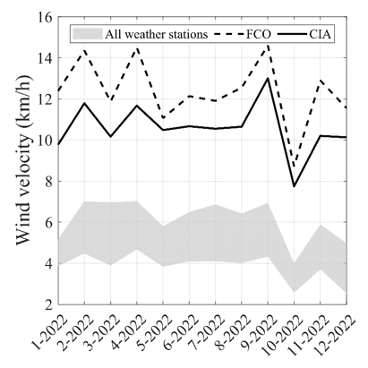
The highest temperatures were recorded in the weather station WS3, located in Rome, during the summer season. In particular, in the months of June 2022 and August 2022 temperatures of around 27℃ and 27.3℃ respectively were registered. As mentioned before, the maximum temperature value, equal to about 28.3℃, were recorded in July 2022. Instead, in June, July, and August 2022, the most significant disparities in temperature were documented between Fiumicino and the other weather stations, with values respectively equal to 25℃, 26.3℃ and 26.2℃. Figure 3 illustrates the recorded trends of wind speed observed at the meteorological stations of Ciampino, Fiumicino, and Rome.
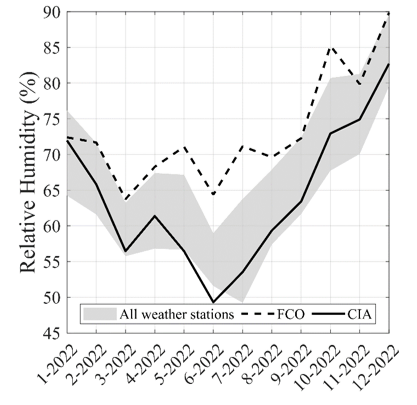
The highest average wind speed values, equal to about 14.5 km/h, were recorded at Fiumicino in the months of February, April and September 2022. Wind speed values registered in CIA are higher than those monitored within the city, with maximum value of around 13 km/h recorded in September 2022. The highest wind speed values in Rome were registered in in the weather station WS4 with maximum values equal to about 7 km/h, logged in the month of February, March, April, July and September 2022. Significantly distinct air circulation patterns characterize the urban context in contrast to the neighbouring zones, primarily due to the presence of tall buildings that hinder and diminish wind flows. Subsequently the relative humidity (RH) data were compared (Figure 4).
Fiumicino is characterized by higher values than Rome and Ciampino, except for the winter season. In summer, due to the proximity of the sea, the recorded humidity values in Fiumicino are higher than the city, with values ranging from about 65% to 72%. The data recorded in Ciampino and Rome follow the same trend, with minimum values in summer of around 50% and maximum values in winter of around 82% in Campino and 90% in Rome.
Figure 3. Monthly average values of wind speed
Figure 4. Monthly average values of relative humidity
Relative humidity influences the reduction of temperatures in the city by diminishing the evapotranspiration effect. The presence of vegetation, urban agriculture, and water bodies, which enhance microclimatic enhancements through the evapotranspiration effect, can play a vital role in environmental cooling [19].
4.2 Assessment of the UHI
In this Section, to assess the UHIIs, the recorded air temperature data from weather stations within the city (WS1, WS2, WS3, and WS4) were compared with those from FCO and CIA weather stations. The UHII values were calculated during the day and night, by applying the UHII definition, which entails calculating the variation in urban and rural air temperatures. Regarding the daytime UHII, the average maximum temperatures registered in Rome and airports were considered, by subtracting the air temperatures recorded by WS1, WS2, WS3 and WS4 stations, and the air temperatures observed by FCO or CIA station (thus considered as reference station outside the city). On the contrary, for the night-time UHII, the same procedure was applied, exploiting the average minimum air temperatures. Figures 5 and 6 present the results obtained for the diurnal and nocturnal UHIIs, also providing their average annual values, respectively with the comparison with FCO and CIA. Examining the UHIIs found by comparing Rome and Fiumicino (Figure 5), it is possible to observe that the highest nocturnal value, approximately 3.5℃, and the maximum diurnal value, around 3.1℃, were recorded in July 2022. Moreover, the average annual values for daytime and night-time are approximately 1.2℃ and 1℃, respectively. Furthermore, through an analysis of the UHIIs derived from the contrast between Rome and Ciampino (Figure 6), it is possible to observe that the highest nocturnal value, approximately 2.2℃, was recorded in March 2022 and the maximum diurnal value, equal to about 2℃, in April 2022. The day and night annual average values are approximately 0.8℃ and 0.45℃, respectively.
Figure 5. UHII considering FCO as reference
Figure 6. UHII considering CIA as reference
A high building density can be correlated to the UHI phenomenon. Heavy building materials and urban canyons increase the phenomenon, trapping the radiant heat. Moreover, high pollution levels cause an infrared absorbing blanket [20]. Additionally, air-conditioning systems contribute to the generation of heat, thus increasing urban air temperatures [21].
4.3 BES: Effects of UHI phenomenon
A simple building was modelled using TRNSYS to explore the impact of different meteorological data on the annual energy requirements. Consequently, the analysis employed the climatic conditions recorded in Ciampino, Fiumicino, and within Rome in 2022.
The annual energy demands obtained through the simulations by applying six different climate datasets are listed in Table 3.
The results show that using the meteorological data recorded in the Rome stations, lower values for heating and higher values for cooling can be observed. Therefore, it is possible to affirm that the increase of temperature caused by the UHI significantly impacts the annual energy demands of buildings in Rome as it caused overheating of urban areas.
Table 3. Simulated annual energy needs
|
Station |
Heating [kWh] |
Cooling [kWh] |
|
FCO |
5401.04 |
3433.18 |
|
CIA |
5441.16 |
4102.24 |
|
WS1 |
5013.27 |
4578.43 |
|
WS2 |
4757.61 |
4938.69 |
|
WS3 |
4464.66 |
5168.79 |
|
WS4 |
5378.96 |
4715.22 |
The proximity of the sea has a mitigating effect on the city of Fiumicino, which therefore opposes the UHI phenomenon. For that reason, the Fiumicino data have been taken as a reference. The percentage variations found for the heating and cooling energy requirements, employing all the considered weather data, are summarized in Table 4.
Based on the overview of these results, it is evident that weather conditions within or outside the urban area affected the annual energy needs with variations ranging from -17.34% to -0.41% for heating, and from 33.36% to 50.55% for cooling. Furthermore, considering the Ciampino weather data the differences in percentage for heating and cooling energy needs correspond to 0.74% and 19.49%, respectively.
Table 4. Variations obtained considering FCO as reference
|
Comparison |
Heating |
Cooling |
|
CIA vs FCO |
0.74% |
19.49% |
|
WS1 vs FCO |
-7.18% |
33.36% |
|
WS2 vs FCO |
-11.91% |
43.85% |
|
WS3 vs FCO |
-17.34% |
50.55% |
|
WS4 vs FCO |
-0.41% |
37.34% |
Considering that usually BES tools deal with data from airports to evaluate the energy demand, and in particular in TRNSYS it is possible to select data from Fiumicino or Ciampino airport, it is evident that the choice of meteorological data plays a critical role in enhancing the accuracy of predicting building energy requirements, considering the influence of the UHI phenomenon within the city.
This study aims at evaluating the local climatic conditions of different areas of Rome, by assessing the UHII values. Furthermore, the energy demands of a detached building were investigated, both in terms of heating and cooling, by means of a dynamic simulation tool. The analysis, grounded on data recorded in the year 2022, carried out from four weather stations located in different parts of Rome, along with the airport stations at Fiumicino and Ciampino.
The obtained results showed a substantial difference between the various climatic parameters obtained outside and inside the city. Analyzing the average monthly air temperature obtained from the considered weather stations, it can be noted that the highest and lowest temperatures were recorded in Rome and Fiumicino, respectively. The biggest difference recorded between the inside and the outside of the city was during summer. The highest temperature was recorded in July 2022 in Rome, with a value of around 27℃. This confirms the presence of the city-based UHI.
Upon analyzing the wind speed data, substantial differences were found between the results obtained from the airport weather stations compared to the meteorological conditions in Rome. Notably, Fiumicino exhibited the highest wind speed values in comparison to Ciampino and Rome, with an average wind speed values equal to about 15 km/h, recorded in the months of February, April and September 2022. In Ciampino the maximum wind speed value was recorded in April 2022, with a value of around 13 km/h. On the contrary the lowest wind speed values were recorded in Rome, with maximum values equal to about 7 km/h, logged in the month of February, March, April, July and September 2022. The results obtained underscore the buildings' capacity to attenuate wind flows. Computing the monthly UHIIs it was possible to evaluate the UHI intensity. The maximum diurnal value and the maximum nocturnal value are equal to about 3.1℃ and 3.5℃, respectively, considering Fiumicino as a reference. In the case of using Ciampino for the air temperature comparison, the maximum diurnal value is approximately 2℃, while the maximum night-time value is about 2.2℃. The analysis of these results highlights the need to adopt cooling strategies in cities that counteract the UHI phenomenon, trough a cross-sectoral approach focusing on green areas and passive solutions such as green roofs [22-25]. By means of TRNSYS, the study examined the impact of varying climatic conditions on the yearly heating and cooling energy demands. This investigation relied on weather data obtained from stations positioned in Rome, Fiumicino, and Ciampino. When considering Fiumicino as a reference and comparing it to the weather station within the city, the findings reveal percentage variations in heating energy demands ranging from -17.34% to -0.41% and in cooling energy demands ranging from 33.36% to 50.55%. On the other hand, examining the outcomes derived from comparing data obtained from the airports stations, the percentage differences for heating and cooling energy demands are 0.74% and 19.49%, respectively. This work highlights the significance of selecting appropriate meteorological data for obtaining accurate simulation results.
It is evident that the use of airport weather data (or climatic data from sites outside a city) results in unreliable estimations of the energy requirements of buildings. The presence of weather stations within the city makes data available that is reliable and easily accessible. Incorporating these data aids in accurately evaluating energy retrofit strategies for existing buildings.
[1] Zhou, X., Huang, Z., Scheuer, B., Wang, H., Zhou, G., Liu, Y. (2023). High-resolution estimation of building energy consumption at the city level. Energy, 275: 127476. https://doi.org/10.1016/j.energy.2023.127476
[2] Sapnken, F.E., Hamed, M.M., Soldo, B., Tamba, J.G. (2023). Modeling energy-efficient building loads using machine-learning algorithms for the design phase. Energy and Buildings, 283: 112807. https://doi.org/10.1016/j.enbuild.2023.112807
[3] Zhong, G., Wang, W. (2022). Optimization of the distribution of green buildings based on urban heat island effect. International Journal of Heat & Technology, 40(1): 333-338. https://doi.org/10.18280/ijht.400140
[4] Kotsiris, G., Androutsopoulos, A., Polychroni, E., Souliotis, M., Kavga, A. (2019). Carbon footprint of green roof installation on school buildings in Greek Mediterranean climatic region. International Journal of Sustainable Energy, 38(9): 866-883. https://doi.org/10.1080/14786451.2019.1605992
[5] Battista, G., Evangelisti, L., Roncone, M., Vollaro, R.D.L. (2021). Analysis of the urban heat island in Rome (Italy): Extent and effects on the building energy performance simulations. Tecnica Italiana-Italian Journal of Engineering Science, 65(2-4): 174-180. https://doi.org/10.18280/ti-ijes.652-405
[6] Liu, S., Kwok, Y.T., Ren, C. (2023). Investigating the impact of urban microclimate on building thermal performance: A case study of dense urban areas in Hong Kong. Sustainable Cities and Society, 94: 104509. https://doi.org/10.1016/j.scs.2023.104509
[7] Ignatius, M., Wong, N.H., Jusuf, S.K. (2016). The significance of using local predicted temperature for cooling load simulation in the tropics. Energy and Buildings, 118: 57-69. https://doi.org/10.1016/j.enbuild.2016.02.043
[8] Lau, S.S.Y., Yang, F., Tai, J., Wu, X.L., Wang, J. (2011). The study of summer-time heat island, built form and fabric in a densely built urban environment in compact Chinese cities: Hong Kong, Guangzhou. International Journal of Sustainable Development, 14(1-2): 30-48. https://doi.org/10.1504/IJSD.2011.039636
[9] Zhao, X., Huang, J., Ye, H., Wang, K., Qiu, Q. (2010). Spatiotemporal changes of the urban heat island of a coastal city in the context of urbanisation. International Journal of Sustainable Development & World Ecology, 17(4): 311-316. https://doi.org/10.1080/13504509.2010.490333
[10] Naikoo, M.W., Islam, A.R.M.T., Mallick, J., Rahman, A. (2022). Land use/land cover change and its impact on surface urban heat island and urban thermal comfort in a metropolitan city. Urban Climate, 41: 101052. https://doi.org/10.1016/j.uclim.2021.101052
[11] Huang, Q., Huang, J., Yang, X., Fang, C., Liang, Y. (2019). Quantifying the seasonal contribution of coupling urban land use types on urban heat island using land contribution index: A case study in Wuhan, China. Sustainable Cities and Society, 44: 666-675. https://doi.org/10.1016/j.scs.2018.10.016
[12] Harmay, N.S.M., Kim, D., Choi, M. (2021). Urban heat island associated with land use/land cover and climate variations in Melbourne, Australia. Sustainable Cities and Society, 69: 102861. https://doi.org/10.1016/j.scs.2021.102861
[13] Xian, G., Crane, M. (2006). An analysis of urban thermal characteristics and associated land cover in Tampa Bay and Las Vegas using Landsat satellite data. Remote Sensing of Environment, 104(2): 147-156. https://doi.org/10.1016/j.rse.2005.09.023
[14] Salvati, A., Monti, P., Roura, H.C., Cecere, C. (2019). Climatic performance of urban textures: Analysis tools for a Mediterranean urban context. Energy and Buildings, 185: 162-179. https://doi.org/10.1016/j.enbuild.2018.12.024
[15] Guattari, C., Evangelisti, L., Balaras, C.A. (2018). On the assessment of urban heat island phenomenon and its effects on building energy performance: A case study of Rome (Italy). Energy and Buildings, 158: 605-615. https://doi.org/10.1016/j.enbuild.2017.10.050
[16] Zinzi, M., Carnielo, E. (2017). Impact of urban temperatures on energy performance and thermal comfort in residential buildings. The case of Rome, Italy. Energy and Buildings, 157: 20-29. https://doi.org/10.1016/j.enbuild.2017.05.021
[17] Battista, G., Evangelisti, L., Guattari, C., Roncone, M., Balaras, C.A. (2023). Space-time estimation of the urban heat island in Rome (Italy): Overall assessment and effects on the energy performance of buildings. Building and Environment, 228: 109878. https://doi.org/10.1016/j.buildenv.2022.109878
[18] TRNSYS Transient System Simulation Tool, (n.d.). http://www.trnsys.com/. (n.d.)
[19] Qiu, G.Y., Li, H.Y., Zhang, Q.T., Chen, W., Liang, X.J., Li, X.Z. (2013). Effects of evapotranspiration on mitigation of urban temperature by vegetation and urban agriculture. Journal of Integrative Agriculture, 12(8): 1307-1315. https://doi.org/10.1016/S2095-3119(13)60543-2
[20] Lazaridis, M. (2011). First principles of meteorology. In First Principles of Meteorology and Air Pollution. Environmental Pollution, 19: 67-118. Springer, Dordrecht. https://doi.org/10.1007/978-94-007-0162-5_2
[21] Mayer, H. (1999). Air pollution in cities. Atmospheric Environment, 33(24-25): 4029-4037. https://doi.org/10.1016/S1352-2310(99)00144-2
[22] D’Souza, U. (2014). Measuring green roof performance, a solution to sustainable urban development in the UAE. International Journal of Sustainable Development and Planning, 9(3): 376-388. https://doi.org/10.2495/SDP-V9-N3-376-388
[23] Meignen, F., Martínez, A., Martí, N. (2020). Greenery in intermediate spaces of the dwellings in the city of Barcelona. International Journal of Sustainable Development and Planning, 15(6): 801-811. https://doi.org/10.18280/ijsdp.150602
[24] Gaspari, J., Boulanger, S.O.M., Antonini, E. (2017). Multi-layered design strategies to adopt smart districts as urban regeneration enablers, International Journal of Sustainable Development and Planning, 12(08): 1247-1259. https://doi.org/10.2495/SDP-V12-N8-1247-1259
[25] Hmood, K.F., Dişli, G. (2019). Sustainable development of Urban conserved heritage: An analytical study of Kursunlu Mosque in Ulus, Ankara. International Journal of Sustainable Development and Planning, 14(3): 273-288. https://doi.org/10.2495/SDP-V14-N3-273-288