Nashwan A. Al-Ansi*![]() | Borhan Uddin
| Borhan Uddin![]() | Abdulaziz Alhrabi
| Abdulaziz Alhrabi![]() | Julaihi Wahid
| Julaihi Wahid![]()
© 2023 IIETA. This article is published by IIETA and is licensed under the CC BY 4.0 license (http://creativecommons.org/licenses/by/4.0/).
OPEN ACCESS
Saudi cities are experiencing rapid urban growth affecting their identity, which was acquired over a long history. In the early twentieth century, new urban planning practices in Saudi Arabian cities were characterized by numerous trends and surrounded by multiple challenges, these trends, and challenges are social, and economical including regional planning, place-making, sustainable urban development, and urban governance. All these trends and challenges have brought traditional Saudi cities into a world that is transforming quickly. These challenges have caused a significant shift in regional cultures over the past few decades, which has prompted planners and designers to prioritize the concept of identity. So, it is important to know how these challenges and policies are impacting the identity of Saudi cities. This research tries to investigate the processes and factors driving swift urbanization, emphasizing the primary causes and impacts of urban growth policy, disruption of the environment, and alteration of city layout. This research also examines how the structures of growing Saudi cities' have been impacted by urbanization and sprawl in general and Buraydah city in particular, as Buraydah is one of those cities that have experienced ambitious urban development policies and expansion in the last few decades. A qualitative approach is employed to explore how can a city achieve distinguishability and represent itself on the global stage. To assess the current scenario of the research area, substantial fieldwork including several site visits, municipal archives, and field surveys was conducted as a part of the practical aspect. The findings indicate that the process of urbanization didn't start with adequate planning for expanding Saudi cities. These cities have gone through radical urban expansion policies, without considering the historic urban pattern, causing the loss of identity.
urbanization, urban sprawl, the structure of the city, loss of local identity
Over the last four decades, various challenging ideas and policies involving different approaches to Urban Growth Management Policy, have led to urban sprawl and expansion trends of traditional Saudi cities. Resulting in the cities entering a world evolving very rapidly [1], rapid urbanization since 1950 AD, with the increasing population growth in Urban areas from 21% in 1950 AD to 58% in 1975 AD, to 83% in 2015, and is expected to reach 86% by 2030 has affected the identity of these cities. Thus, the topic of identity is one of the fundamental issues related to urban policy that will likely influence the future decades [2]. The architectural character and the city's identity, which generally took generations to develop, are affected adversely by growing urbanization and also bring challenges related to the environment, society, and the economy. Therefore, the most important question arises here: how can a city achieve distinguishability and represent itself on the global stage? Saudi Vision 2030 as an approach to develop inclusive, sustainable, resilient, and safe cities and neighborhoods, by safeguarding old cities which have architectural and historical significance, is one of the programs adopted in 2016 [3]. A significant part in strengthening local identity, memory, and belongingness is played by traditional urban areas. So, the identity of the city is considered to reflect a flexible, inventive, and practical framework for addressing regional and global concerns with pragmatism and effectiveness [4]. Previous research related to factors that, contribute to urban sprawl has shed light on how to manage urban changes that affect the form and pattern of cities. The current study discussed and analyzed these factors and the related urban plans, which identified the massive expansion of these Saudi cities. It also shows the inability of these urban plans to control the swift expansion of these cities due to the population surge and economic boom. Several problems have emerged as a result of population growth and urbanization, which have altered land use patterns and the natural environment of cities, justifying the importance of discussing the loss of identity of cities [5]. Therefore, as a result of Saudi Arabia's ongoing trend of rapid urbanization, the effects of urban expansion have become a growing concern impacting the Saudi city's identity, which this study attempts to diagnose by exploring the causes and ways to address.
This section of the study aims to demonstrate the current condition of expanding Saudi cities, it addresses the main issues Saudi Arabia's urban areas face that directly lead to the loss of these cities' identity, as well as the potential they have to support sustainable national growth and preserve regional identity. To understand the issue of losing identity in growing Saudi cities and Buraydah city, in particular, it is necessary to explore and analyze the driving forces and dynamics of emerging urbanization trends (rapid urbanization). Urbanization may be used as a driving force for the adequate and sustainable development of Saudi Arabia's cities when it is well-planned and managed while preserving the local built character and natural environment. Therefore, the government decided to implement the Future of Saudi Cities program through the Ministry of Municipal and Rural Affairs in 2013, collaborating with UN-Habitat. The Future of Saudi Cities program (FSCP) aims to achieve sustainable urban development in Saudi cities, by protecting local urban patterns, supporting economically productive cities, and improving urban legislation and institutional framework.
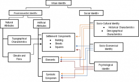
Figure 1. Formation of urban identity
Source: [6]
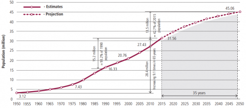
Figure 2. Population growth in Saudi Arabia, 1950–2050
Source: [7]
2.1 Definition of identity
"The distinguishing character or condition of a person or thing" is defined as identity [8]. Identity is also defined by Lynch [9] as "the extent to which a person can recognize or recall a place as being distinct from other places." In terms of cities and urban identity, the term identity has a comprehensive definition that includes natural and human-caused factors, economic and cultural characteristics, and social conventions [10]. Identity is a combination of distinguishing characteristics (physical or behavioral) that allow a person or object to be recognized or identified. Individuals' engagement in changing historical events through cultural identity, on the other hand, is a social process like historical reservoirs [11]. In other terms, identity is a person's or thing's distinguishing characteristic or condition about a location within historically specified contexts. Several elements specific to each city determine a city's unique identity, which may be classified into several categories such as architectural, social, cultural, political, psychological, emotional, and so on [12]. Previous research has found that the concept of identity has both social and physical meanings, where a set of indicators is identified by a group of individuals at a certain time and location. However, people and locations change with time [13]. In that way, identity can change, and people can ignore this change because they prefer to maintain a sense of continuity. However, the idea of identity continuity is controversial. Every civilization has the problem of retaining its identity at any time, particularly in times of rapid economic and technological development [14]. In conclusion, identity may be defined as the collective component of the set of distinctive qualities (behavioral or physical attributes) that make a thing or person recognized or known.
2.1.1 The city’s urban identity concept
There is no common definition of Urban Identity, it has not been solved or agreed upon between the various responsible parties. As a result, urban identity is currently a highly controversial topic that many notable scholars and urban planners have approached from many perspectives. According to Butina-Watson and Bentley [15], any place should have its unique character – “identity”, that people, use – to distinguish it from other places. Which is referred to as “Place Identity". Now it seems people from all over the world are interested in this question, promoting an understanding of what place-identity might mean. Other scholars believe that Place identity is a "set of meanings related to a specific cultural setting that any specific person or group individuals depend on in the development of their particular social and personal identities" [16]. Previous research has suggested that urban identity may also be described as the city's physical identity, which is connected to dependency conformity and offers a sense of place, helping individuals to identify with a variety of locations [17]. Furthermore, the city's urban fabric is impacted by a few factors that influence the city's identity, which distinguishes it from other cities. As a result, a city's physical identity renders correlations between the city's structure and itself. Regardless of style, the characteristics allow the city's urban fabric to grow, which may contribute to the formation of the city's urban identity. In this process, the city's physical identity plays a role in the development of the urban tissue structure. As a result, the urban characteristic is identical to the city's physical identity (see Figure 1). It expresses one of the city's attributes that focuses on the form of the city. The city’s urban characteristics and physical identity are two phrases that describe a concept. Although Kropf [18] argues that cities are distinguished by the differences that they share, the physical identity of the city identifies cities based on commonalities.
2.2 Urban trends in Saudi Arabian cities
The rapid urbanization trends can be classified into two aspects, the demographic and urban change trend categories. The impacts of these urbanization trends will be highlighted in this part of the literature review. Saudi Arabia has seen substantial demographic changes in the previous 50 years, which have had a profound influence on its urban growth. The primary trends in demographics include rapid population growth, aging populations, and a growing number of young and working adults see Figure 2 [19]. Rapid urbanization has led to the dynamism of the city, which includes an evolving process that can destroy and replace its layout. It is represented as one of the main challenges that cities will undergo due to the impact of urban sprawl, which has a significantly negative impact on the size and the city's structure, in turn, will have a greater negative impact on the city's identity [20].
Because urban sprawl is one of the consequences of the rising tendencies of rapidly growing urbanization, cities, and architectural structures endure an emerging urban and architectural transforming process that leads them to lose their identity. Therefore, one aims for the future development of a healthy environment is identity of the most important. A city in a growth-decline cycle cannot sustain sustainable development without the sort of urban identity that culture-led urban regeneration can provide. Thus, integrating place identity, urban sustainability, and globalization is one of the underlying challenges in sustainable urban regeneration and inclusive development of cities [21]. According to Sepe [22], the sustainability of a place is determined by factors such as livability, quality, and identity. Furthermore, the globalization of culture has sparked questions in recent years about the loss of identity and difference from one location to another. This is why the concept of place identity has become a crucial challenge for city planning and design, as well as an essential aspect of sustainable development [22]. As a result, at the urban level, the environment should inspire individuals to express themselves and contribute; people should feel as if they own a part of the environment. Furthermore, by reinforcing the environment of the districts, a creative design approach may heighten local identity and create distinctive locations [23]. As a result, communities must achieve urban sustainability by implementing city-appropriate urban regeneration policies and initiatives that enrich the city's distinctive identity [11]. Though urban regeneration should be done holistically, strategies for urban regeneration vary according to local factors. In this respect, the study of urban regeneration typologies is important for adapted urbanization. Deog-Seong Oh identified the following categories of urban regeneration (Table 1).
According to the Table 1, it is clear that sustaining a city's identity has been increasingly challenging in recent years because of urbanization, transportation, and technical improvements, as well as short-lived urban trends indicated by capitalist contests or utopian ideologies.
Table 1. Urban regeneration types identified by Deog-Seong Oh
|
Type |
Explanation |
|
Resource-saving type |
Utilizing all the components that compose the urban system as well as physical and environmental factors. Cities: Hamburg (German) |
|
Creative city type |
Obtaining the effects of urban regeneration by utilizing all intangible or tangible cultural resources in the urban area. Cities: Barcelona, Bilbao (Spain), Yokohama (Japan) |
|
Growth management types |
Finding an alternative and diagnosing the decline in the city center occurring during metropolitanization. Cities: Sheffield (UK), Austin (USA) |
|
Industry-based type |
Making a self-contained mixed city through both economic functions and residential functions. Cities: Nottingham (UK), Sophia Antipolis (France), Dortmund (German) |
|
Reducing-carbon type |
Reducing emissions of carbon that cause global warming and absorbing carbon already emitted into the air. Cities: Malmo (Sweden), Freiburg (German) |
Source: [11]
2.2.1 Urban planning trends and challenges in Saudi Arabia cities (Taif City)
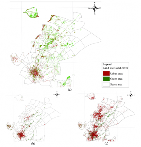
Saudi Arabia witnessed short- and medium-term plans at the state level, such as the five-year national development plans that began in the 1970s, a long-term strategy that the Kingdom had never seen before. It is usually considered as a spending plan for countries to build the necessary infrastructure to support economic and social development. However, these plans were not adopted, even partially. Urban planning is a field that addresses the existing urban environment of cities and their local identity, especially historical cities, yet no definition of urban identity was categorically adopted [24]. Al-Harithi’s [25] study, dealt with the city of Taif as one of the traditional Saudi cities that expanded significantly over the past thirty years, from 1990 to 2022. The city’s urban plans approved by the Taif Municipality, which is responsible and organized for urban planning in the city, ignored the historical aspect of the city and its geography. Its geographical location greatly influenced its local identity. The city of Taif is considered a vital crossroads between the eastern and western parts of the Kingdom of Saudi Arabia, making it a tourist destination, as well as a commercial and agricultural destination for many years [25]. The study shows that there were no modern scientific studies conducted that dealt with the spatial analysis of urban expansion and its trends in the city of Taif. It traced the stages of expansion in time that greatly affected the city’s structure and identity. The large number of development projects in the city of Taif has caused an increase in demand for residential, commercial, industrial, and service complexes, which has resulted in urban sprawl in all directions of the city. The results also revealed that over the past thirty years, urban land cover has increased by 20,448 hectares, while it has decreased other land covers, particularly green areas that characterized the city and gave it its local identity, decreased significantly by 14,554 hectares. The results also indicate that the rate of increase in urban areas reached 114.8% during the period from 1990 to 2020. Figures 1 and 2 show classification, land use, and land cover [25].
2.3 Modernization and rapid urbanization and the lost identity of the city
Rapid urbanization in various countries has brought out several obstacles to urban growth. This is related to inadequate urban planning methods for development process management. From a global view, the wave of globalization is like a horrible storm that perturbs all the inhabitants of the modern world (see Figure 3). Consequently, humanities communities have faced a different challenge, most importantly, loss of identity among the various waves of globalization [26]. The main factors influencing a city's identity are the process of modernization and rapid urbanization. As a result, cities have developed and grown bigger, and the structure of cities' urban centers has been drastically altered in recent years. This indicates the deterioration of an urban identity is an inevitable consequence of growing urbanization [27]. These factors also had an impact on Saudi cities as well. Aside from the extraction of oil and its involvement in economic activity, the political aspect has played a significant role in urbanization. Saudi Arabia has been able to build up an advanced urban economy along with rapid urbanization because of the powerful political commitment of a stable government and economic resources. All of this has resulted in several issues, such as undertaking uncoordinated developments and urban strategy plans, Master Plans, and Action Area Plans; yet, their execution has been inadequate, resulting in the unstructured expansion of cities [9]. Unfortunately, from above, it can be concluded that fast urbanization and modernization as well as identical buildings, harmed the city's historical character, influencing the city's identity within the socio-cultural and social-physical transformations in the city's context and people's lifestyle. Just little modifications to the characters that create urban identity might result in differing patterns and identities in different areas of cities. Modernization and increasing urbanization currently influence every nation, having an impact on cultural and social affairs. Furthermore, modernization and the rapid process of urbanization cause cities to be identical in form, impacting spaces for living, the built environment, and the cities' urban character. Because of the process of city development, changes to economics take place, and the city's urban identity transforms [28].
2.4 Reasons for fading of identity
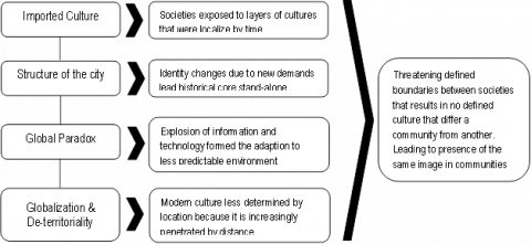
Adopting traditional urban characteristics, architectural style approaches to design, and decorative elements while using local construction materials and construction methods is a common way to express urban identity. However, through worldwide trade, the mass media, commercial ties, and the free flow of individuals, thoughts, and wealth, the earth has been reduced to the size of a village, resulting in remarkable similarities among cities throughout the world (see Figure 4).
Figure 3. Land use land cover classified classes a, b, and c (1990, 2002, and 2020)
Source: [ 29]
Figure 4. Factors affecting the fading of identity
Cities' identities have both social and physical meanings that transform over time according to historical, cultural, economic, and aesthetic factors. This transformation becomes appropriate if it develops simultaneously without the loss of existing identity [30]. Cities possess unique characteristics that contribute to both their physical and urban integrity. Cities have distinct characteristics and identities, implying that they possess unique characteristics which set them apart from others. Unfortunately, nowadays cities are losing their distinct identities, and new urban and architectural developments are taking place [4]. To fully understand the loss of identity, it is necessary to recognize and assess the major challenges of growing urban developments in Saudi urban areas, in addition to determining the factors that have a greater impact on the city's transforming identity, particularly in newly developed neighborhoods related to historic neighborhoods. These challenges are typically classified into four categories: uncoordinated expansion, unsustainable consumption, urban growth management, and urban governance.
3.1 Study area
In this study, Buraydah City has been chosen as it provides a fine illustration that represents the status of the city's identity loss, and challenges of emerging urban trends in Saudi cities. Buraydah city (Al-Qassim) in the Najd region is well-known for its distinctive cultural features. Buraydah is rapidly urbanizing due to economic development, which has resulted in urban expansion, along with many buildings built without considering the urban fabric of historic cities [31]. Saudi society has undergone a significant socioeconomic transition because of the extensive embracing of modern technology, urbanization, rapid growth, and modernization [32]. These changes had a considerable influence on residents' lifestyles and needs from their dwellings. Most people rapidly gave up their traditional customs due to these major changes, and cities started losing their distinctive identity in the kingdom [33]. Buraydah City's urban expansion dynamics include significant changes in its identity due to rapid urbanization. This stimulated the city's expansion, and as a result, many of the new neighborhoods expanded alongside the major corridor and city entrance, resulting in a considerable alteration in the city's layout (see Figure 5) [34].
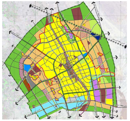
Figure 5. Proposed Land Use - Buraydah Local Plan
Source: Buraydah Local Plan Report - Municipality of Qassim Region
3.1.1 Buraydah– its identity and formation
Buraydah City is on a vast plain in the middle of the Al-Qassim province and is its capital and largest city. Administrative functions make up (45.3%) of the entire economy, followed by the service-based sector (15.5%) and the financial sector (10.3%). Table 2 shows that the agriculture sector contributes (1.1%) [35]. The agricultural land is located outside of the city's urban mass. The rate of urbanization in Saudi Arabia's different regions, as seen in Figure 6, reflects the country's regional imbalance. Jeddah, Riyadh, and the Eastern Region are among the most urbanized, with 88 percent, 91 percent, and 93 percent, respectively, while Buraydah has 73 percent. Medium-sized cities (with populations ranging from 300,000 to one million) are witnessing population growth, at a far slower rate than larger cities. In addition, 3.4 million people are predicted to move to these cities by 2030. Hufuf-Mubarraz, Taif, Tabuk, and Buraydah are among the cities in this category [36]. Lack of proper planning, the distribution of urban population along certain corridors, and the expansion in the size of big and medium cities will lead to a transformation of the form of the cities, which may lose their unique identities over the years. As a result, there will be a major challenge to provide an adequate master plan to promote the character of these cities, as well as other essential infrastructure required for the cities' effective functioning.
Table 2. The structure of urban economic activity of Buraydah City
|
Sectors of Economic Activities |
Percentage |
|
The activity of the local public administration sector (the government) |
45.3 |
|
Services sector |
15.5 |
|
Industry sector |
2.6 |
|
Trade Sector |
10.3 |
|
Transport and communications sector |
1.5 |
|
Agriculture and fishing/hunting sector |
1.1 |
|
The construction sectors |
5.8 |
|
Not working |
17.9 |
|
Total |
100 |
Source: [35]
Figure 6. Regional levels of urbanization in some Saudi Arabia regions
Source: [34]
3.2 Research methodology
To address the research objectives, the research emphasizes two aspects in this portion, namely theoretical as well as practical. The theoretical aspect was examined by a survey of the international theoretical studies on the concepts of urban characters, such as identity, the City’s urban identity, and urban land use planning. Furthermore, the land use planning process is examined to identify inefficient land use planning, contributing to the loss of city identities. The first objective of this study, as presented in the earliest section, is to understand Urban growth policy and the critical factors that govern the loss of identity in expanding Saudi cities, particularly in Buraydah. Based on a review of the available literature concerning the research strategies used in similar studies, the research method adopted for this study was a qualitative approach to gathering data from multiple sources [29]. A qualitative study explores the identification of different factors interacting with each other [37]. The case observed is a real situation that was studied and shows the process of urban expansion through a detailed investigation of documents. Historical methods, case studies, and ethnography were the three main methods of research that were applied [27].
This part represents and analyzes the findings of the data analysis based on the literature review, historical methods, case studies, and ethnography. It begins with the presentation and discussion of the result of the analysis of the rapid urbanization spurred by natural population growth, modernization, and the urban growth policy of Dammam, Hail, and particularly Buraydah which have dramatically altered the cities’ urban patterns. Secondly, the section examines the empirical investigation’s findings of the challenges arising from the urban trends that directly have an impact on the loss of the identity of these Saudi cities; these challenges are, uncoordinated expansion, unsustainable consumption, urban growth policy, and urban governance. At the same time, this part includes several concepts meant to provide the reader with an understanding of the research's primary topic, which is to identify the cause and effects of urban expansion on the loss of identity in expanding Saudi cities, along with finding the possibilities for promoting national and sustainable growth while improving the local identities of these cities.
4.1 The reality of Buraydah planning (1975-present, case study)
In this section, the study will give more elaboration on the urban development history of Buraydah from 1975 till it has taken its present form without the consideration of the identity that characterizes it. Studying Buraydah's developmental phases helps us understand the city's environment, the connection between function and morphology, the city's internal arrangement, and the facts of development and its effect on the city's identity. Therefore, Introducing the planning history and the analysis of the existing conditions of the city covering demographic information, urban growth trends, land use patterns, and Urban sprawl gives a clearer picture of understanding the Identity in the changing context of the city.
4.1.1 Imbalanced and unsustainable patterns of urban development and identity of Buraydah (1975-present)
The plans prepared for Buraydah were extremely ambitious and aimed to focus on development in the urban core (Doxiadis) and by creating urban centers (NorConsult), some of the plan's initiatives were not followed and unorganized developments were established throughout the city. The current study, by studying the planning/planning stages that the city went through, attempts to show the reality of Buraydah planning and the stages that the city of Buraydah went through until it took its current form as follows:
The Doxiadis proposal plan for the city of Buraydah was not implemented because of the population growth that was much bigger than the plan adopted in 1403H, which considered the privacy and identity of the old city (see Figure 7). Therefore, many modern residential developments are now outside the region that Doxiadis had planned, which has moved away from the local identity that characterized the old city of Buraydah, especially the developments in the north of Buraydah, and the linear form on which the Doxiadis scheme is based was modified (see Figure 5). The industrial zone in the south that was proposed had yet to be constructed since most industrial growth had occurred elsewhere. Takes a random longitudinal form on the main road in the south towards Unaizah city.
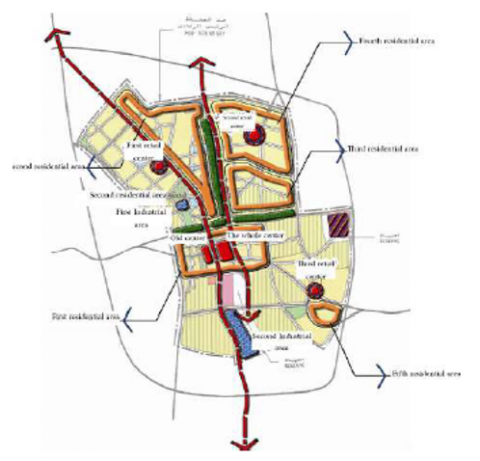
During this period (NORCONSULT) Buraydah authorities adopted ambitious plans and worked to achieve the goal of developing residential areas (first, second, third, and fifth) as well as the target of Industrial development with a change in some sites (see Figure 8). The target of integrated centers or shopping centers was not implemented except in the old center and the first commercial center, which aims to enhance the identity of the city and the characteristics that distinguish it as one of the cities of the Najd region. Also, the target of the recreational areas has not been implemented as well [38].
Figure 7. Doxiadis Plan 1395 H/ 1975
From the analysis of the first and second stages of Buraydah's planning history, its origin, formation, and the reality of Buraydah's planning, it can be seen that the city grew from a little cluster within the old town walls in 1332H to a tremendously expanding city. Buraydah has evolved over the years as an important center of trade due to the Kingdom's rapid economic growth. In turn, this contributed to the receiving of a significant flow of people into the city in addition to the increasing natural population growth, all these have led to urban sprawl, the rapid expansion of the city towards the suburbs and the countryside, the city expands in all directions, and urban sprawl emerged in different areas of the city, a phenomenon that is still going on now.
Figure 8. Indicative Plans - NorConsult 1405 H/ 1985
4.1.2 Buraydah urban growth policy challenges
By examining the planning history and the stages of development of Buraydah City, it is clear that the city's population increased rapidly, and because of the city's rapid expansion, it has grown outside its borders. Furthermore, several characteristics that impact the city's identity have been overlooked during this transition. As a result, it is evident to argue that an urban growth policy that ignores the city's character and identity during its transformation phase portrays the picture of an unsustainable urban fabric. The city gradually lost its distinctive architectural and urban traits, causing the neighborhoods to lose their identity. This is what can be seen in Saudi cities like Dammam, Hail, and Buraydah, which was elaborated on in the previous sections and was also addressed in the planning history that applied to Buraydah city until it took its present structure form. The following section will elaborate on the third and fourth stages, showing the reality of Buraydah's planning. These stages are more important to show the emergence of city identity changes that began during these stages and continued in the increasing trend until the present.
According to the studies of Buraydah’s urban growth boundary strategy, during 1987 and the updated 2006, suitable development of lands for urban and regional uses in the long term while maintaining and increasing agricultural lands was proposed (see Figures 9, 10). Unfortunately, this strategy did not work, as around 70% of the urban development from the year 1989 to the year 2004 was limited within the urban boundary of the year 2004. Then the city extended in the form of approved schemes toward the north and west near the village of Al Basar as an indication that was previously clarified because of continuous urban sprawl. Later Al-Basar village was included in the areas swallowed by the city's urban sprawl. It is worth mentioning that approved development schemes within the urban boundary for the year 2004 were up to about 60%, and the development in the approved plans outside the urban boundary did not exceed 25% [38].
Figure 9. Buraydah Urban Growth Boundary 1407 H
Figure 10. Buraydah Urban Growth Boundary 1427 H
Figure 11. Buraydah Structure Plan (Update) 1428 H
Due to the resulting population congestion of a large influx of population into the city, in addition to the increasing natural population growth that altered the city's urban expansion pattern due to internal migration, the city began to creep into other directions during the past few years. The Ministry of Municipal and Rural Affairs "MoMRA" developed and implemented a study of the longitudinal axis from south to north (the portion between King Khalid Road and King Abdullah Road) in distributing for government-owned commercial and residential functions. Additionally, it prioritized the horizontal axis from east to west (Riyadh-Medina route) and distributed them to local services; certain areas have been allocated for industrial function in the city's south-eastern and eastern north, surrounded by an agricultural zone. Several areas on the city's south and west sides have also been designated for investment in agriculture. On the northern side, areas were reserved for residential use. The illustration below represents the 2017 Buraydah [38] structural plan (see Figure 11).
Assessing the planning history and the third and fourth stages of development of Buraydah city reveals that, along with the increasing natural population growth, a significant influx of people into the city led to urban sprawl and rapid expansion of this city towards the outskirts and the surrounding area. It is undeniably a natural outcome, but the emergence of new construction patterns such as buildings and transportation networks is not without flaws. More than benefits, it directly affects the city's identity. The absence of adequate and thoughtful planning negates the city's identity and characteristics, leading to the loss of its aesthetics and identity. Furthermore, urban sprawl endangers the city's original environment, and internal layout, and affects the city's identity.
4.1.3 The city’s development patterns
Starting from 1972 to the present time, Buraydah's population increased rapidly, rising from 60,000 in 1969 to over 180,000 people in 1988. The population continued to grow at an ever-increasing speed, rising from 378,422 in 2004 to 669,000 in 2020, 700,000 in 2022, and 714,000 in 2023, respectively [39]. The increase in population in 48 years is more than 1,000% see Figure 12. Unfortunately, many modern residential developments are now outside the region that Doxiadis had planned, which has moved away from the local identity that characterized the old city of Buraydah, especially the development of the new areas in the north of Buraydah. As a result of all these issues, in 2015, the Ministry of Municipal and Rural Affairs adopted a new Local Plan for the city of Buraydah, highlighting the primary administrative borders for the city of Buraydah by the borders of the three sub-municipalities. These administrative borders include the city's Urban Growth Boundary (UGB) (stages 1435, 1440, 1445, and 1450), see Figure 13, which determines appropriate lands for urban development. Additionally, these administrative borders contain the Development Protection Boundary (DPB), which maintains the existing urban footprint and urban growth pattern. All these aimed to control urban growth and limit urban sprawl on the city's outskirts by using appropriate urban identity as an emerging idea and diagnostic tool to generate a distinctive sense of community and urban character. As mentioned above, the Urban Growth Boundary (UGB) regulates urban growth, while the Development Protection Boundary (DPB) controls urban sprawl on the city's periphery. However, since 1435, the Buraydah Urban Growth Boundary (UGB) has contradicted its primary aim by approving and promoting urban sprawl initiatives around the city. Present-day urban Growth Boundary (UGB) (1450) is not just one boundary that surrounds the urban region, instead, it is a collection of smaller areas that cover the sprawl developments on the outskirts, (see Figure 13). Likewise, the Development Protection Boundary (DPB) has had adverse outcomes (see Figure 13). Rather than concentrating on the urban area, builders took advantage of it to build plots beyond its boundaries, resulting in massive urban sprawl around Buraydah. This had a significant impact on the city's identity, and as a result, the city drifted out of its distinctive characteristics and in places even lost it entirely.
Figure 12. Current distribution of population density
Figure 13. Administrative boundaries in Buraydah Metropolitan Area
4.1.4 Growth centers policy: challenges of preserving the identity of Saudi cities
One of the primary objectives of the National Spatial Strategy is to promote spatially integrated development. Yet, 17 years after implementing the strategy and the growth center or growth pole policy, more time and improvement are required to preserve Saudi cities' identity. Even though such strategies worked to develop these cities, they led to uncontrolled urban development, which has significantly changed the urban identity.
4.2 Imbalanced urban development challenges (Dammam, and Ha’il City)
The demand for "new" urban areas is a result of the Kingdom of Saudi Arabia's increasing urbanization and as a sustainable reaction to this growth, there should be balanced development to preserve the identity of Saudi cities with historical urban patterns. The highest priority must be given to the intensification of vacant lands instead of the expansion of towns in an unexpected way that works on losing cities to their identity. Therefore, given the abundance of empty land in a lot of cities, dynamic urban design approaches such as urban stability and compact development are necessary. It is evident that the primary urban growth policy approach followed in some Saudi cities is to expand the city's boundaries. This type of growth of cities results in vast continuous urban masses that are inefficient in many ways and pose a significant challenge to a city's cultural and regional identity. According to Table 3, the percentage of unoccupied land inside the limits of a few selected Saudi cities ranges from 46% in Dammam to 90% in Ha'il, while it is 68 % in Buraydah city (the case study) [40]. This unoccupied property occurs in the shape of urban plots that remain empty since the owners do not have incentives to develop. A critical challenge is how the authorities intend to cope with the predicted growth in urbanization within the context of the country's vast areas of undeveloped city territory. Unfortunately, this process harmed the cities’ identity.
See Table 3 for more information on Saudi city profiles and unoccupied lands. The analysis of the Ha'il City Area, for example, suggests that expanding its unoccupied land following UN-Habitat density requirements of 150 people per hectare (pp/ha) would enable the city to accommodate an extra 682,800 residents. With 46% unoccupied land and a 3% growth rate, Dammam will require over 60 years to occupy its urban limit at the proposed density of 150 pp/ha. Buraydah, for example, has around 81 percent of its overall land empty. According to the city profile research, it will require over 100 years to occupy it at the present rate of growth of 3.4 percent [33]. Aside from the different challenges associated with urban sprawl, one of the most dominant and serious issues in these Saudi metropolitan areas is the use of urban land in the shape of sprawl. Because of these cities' high population expansion, the physical limit of urban regions is increasing more rapidly, meaning greater use of urban and adjacent land. Table 4 indicates the extent of the spatial expansion of Saudi cities for different periods, see Figure 14 & Figure 15.
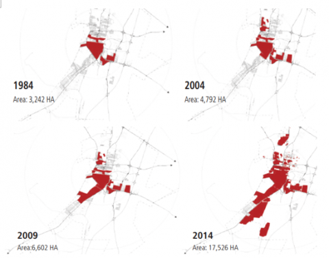
The most interesting case seen from above is Dammam, which demonstrates that during the thirteen years from 2004 to 2017, the city expanded more than four times, and Ha'il, with an estimated population of less than 400,000, expanded its total area of more than three and a half times over ten years starting in 2004.
Table 3. Vacant land in selected Saudi cities
|
City |
Vacant Land (%) |
|
|
Within Urban Growth Boundaries |
Within the Built-Up Area |
|
|
Buraydah |
68 |
37 |
|
Dammam |
46 |
48 |
|
Ha’il |
90 |
55 |
|
Jeddah |
61 |
N/A |
|
Madinah |
41 |
12 |
|
Tabuk |
71 |
36 |
Source: [34]
Table 4. City and population growth in Saudi Arabia
|
City |
Duration |
Number of Years |
Increase in Building Mass |
Increase in Population |
|
Buraydah |
1995 -2015 |
20 |
2.2 x |
2.2 x |
|
Dammam |
2004 - 2017 |
13 |
4.1 x |
1.9 x |
|
Ha’il |
2004 -2014 |
10 |
3.7 x |
1.3 x |
|
Jeddah |
2007 -2017 |
10 |
1.6 x |
1.3 x |
|
Madinah |
2002 - 2015 |
13 |
1.5 x |
1.2 x |
|
Tabuk |
2006 - 2017 |
11 |
1.9 x |
1.5 x |
Source: [34]
Figure 14. Spatial expansion in Dammam
Source: [34]
Figure 15. Spatial expansion in Ha’il
Source: [34]
Based on the results and findings from the data analysis, and the discussion, concerning the study’s objectives, the following points can be concluded. Firstly, the study shows that Urbanization in some Saudi cities like Dammam, Hail, and Buraydah lacks a coherent plan and urban growth policy related to preserving the cities' identity. As a result, the loss of city identity is a grave issue in these Saudi cities particularly in Buraydah. The signs and consequences of rapid urban growth are obvious, and the development policy used in these cities is inconsistent with the traditional character of society. Based on the first question of this research, how the challenges and policies related to urban expansions are impacting the identity of Saudi cities, the findings of the literature review and the case study of Buraydah City indicate that the key underlying factors of city identity loss are, economic growth, rapid urbanization, and urban growth policy that in turn caused the urban sprawl which has led to substantial changes to the city's structure. Therefore, the government needs to confront and address the following key factors: i) imbalanced development, the development of “new areas” within cities, in response to the increased rapid urbanization in the Kingdom of Saudi Arabia there should be balanced development to preserve the identity of Saudi cities. The development of vacant lands must be prioritized above the expansion of city limits as the primary urban growth management policy in Saudi cities, which in turn has led to urban sprawl and the expansion of cities in an unexpected way that significantly changes the shape and structure of these Saudi cities, which led loss of their identity. ii) Unsustainable growth patterns occurred due to different development plans and proposed urban growth boundaries to address population growth. Some of the initiatives of these plans were not implemented, and the urban growth boundary was manipulated by developers by developing more plots and residential areas along the edge of the proposed city limit, creating an unorganized growth pattern. These plans and unorganized development led to the expansion of the city in all directions while ignoring the local identity. This is why the urban population growth must be taken into consideration along with the preservation of local identity to tackle the unsustainable growth pattern of the city.
Secondly, the question regarding the case study (Buraydah city) how the structures of growing Saudi cities' have been impacted by urbanization and sprawl in general and Buraydah city in particular, the findings and study of the traditional urban fabric of Buraydah indicated that even though historic landmarks and urban patterns are important in building the urban identity of a city, the recent urban planning for improving these areas didn’t prioritize these issues. This can be explained through the inadequate standard of these plans regarding local relevance and character since they were identified as the town's most unlikely elements. Furthermore, this research suggested that the city's historical urban fabric and its natural surroundings had a considerable influence on shaping the urban identity, along with the conventional lifestyles visible in the old neighborhoods. Due to the absence of an appropriate pattern and integration, these were not thought of in any form within the newly built neighborhoods.
It must be acknowledged that during the research certain limitations have appeared. Even though the impact of local urban patterns has proven to be one of the key factors in molding the identity of the city. Most of the historic sites and patterns within the city of Buraydah (the case study) have already been demolished. Hence the relevance of the study materials mostly depended on archival research. Which at the same time offers the possibility of future research on how to revive the lost historical character and sites through detailed investigation, documentation, and restoration.
Recommendation
The following might be proposed to preserve the identity of Buraydah and any other Saudi cities having distinct built, natural, and socio-environmental aspects and rapid urban growth:
Along with those mentioned above, planned city infill, which is prominent in the NUA, can provide valuable tools for executing urban growth and densification strategies to protect the Saudi city's inherent character from loss. Future urban expansion can be dealt with by an organized method if Planned city infills can be adapted, in addition to unproductive and speculative regions, planned city infills may prevent urban development over wide areas that produce a form and framework that differs from the city's local character. With fragmented areas and an urban fabric consisting of separate zones, planned city infills can be useful solutions for preserving the city's form and local identity gained over many years. Infills will also perform effectively for large unoccupied land, particularly in low-density communities.
[1] Alshuwaikhat, H., Aina, Y., Rahman, S.M. (2006). Integration of urban growth management and strategic environmental assessment to ensure sustainable urban development: The case of Arabian Gulf cities. International Journal of Sustainable Development and Planning, 1(2): 203-213. https://doi.org/10.2495/SDP-V1-N2-203-213
[2] Abou-Korin, A.A., Al-Shihri, F.S. (2015). Rapid urbanization and sustainability in Saudi Arabia: The case of Dammam metropolitan area. Journal of Sustainable Development, 8(9): 52-65.
[3] K.S.A. (2016). Development programmer overview, Crown Prince Mohammad bin Salman, Government of Saudi Arabia, http://www.vision 2030.gov.sa/, accessed on Apr. 25, 2016.
[4] Donboli, Safa, A.A, Abad, H.K.K. (2017). Components of the citys physical identity: A review of in Iranian cities. Current World Environment, 12(2): 237-249. http://doi.org/10.12944/CWE.12.2.07
[5] Alnaim, M. (2006). The Home Environment in Saudi Arabia and Gulf State: Growth of Identity crises and Origin of Identity. Crissma, Vol. 1, Milano.
[6] Ökesli, A.P.D.D.S., Gürçinar, Y. (2012). An investigation of urban image and identity findings from Adana. Çukurova Üniversitesi Sosyal Bilimler Enstitüsü Dergisi, 21(1): 37-52.
[7] United Nations. (2017). The Future Saudi Cities Programme is a jointly implemented project managed by the Deputyship of Town Planning of the Ministry of Municipality and Rural Affairs of the Government of the Kingdom of Saudi Arabia and the United Nations Human Settlements Programme (UNHabitat).
[8] Lynch, K. (1961). The Image of the City. MIT Press, Cambridge, MA
[9] Al-Suhaimi, A. (2014). Riyadh: Early history. http://www.arifalsu haimi. info/history.php.
[10] Rifaioğlu, M.N., Şahin Güçhan, N. (2007). The concept of identity and its identification process in urban conservation projects. In An International Conference of CSAAR on Regional Architecture and Identity in the Age of Globalization, 3: 1099-1111.
[11] ICCROM Team. (2003). Introducing Young People to the Protection of Heritage Sites and Historic Cities, A Practical Guide for School Teachers in The Arab Region, UNESCO, 1st edition.
[12] Mohammad. J. Maqsoodi, Abdullah, A., Bahauddin, A., Marzbali, M.H. (2013). The influence of landuse planning on the making of the cities physical identity in Iran: An analytical review and commentary. Middle-East Journal of Scientific Research, 14(6): 762-772. https://doi.org/10.5829/idosi.mejsr.2013.14.6.685
[13] El Menchawy, A., Aly, S.S., Hakim, M.A. (2011). The impact of urban sprawl on the heritage areas through the urban fabric of cities. WIT Transactions on Ecology and the Environment, 150: 299-314.
[14] Al-Naim, M. (2008). Identity in transitional context: Open-ended local architecture in Saudi Arabia. International Journal of Architectural Research, 2(2): 125-146.
[15] Butina-Watson, G., Bentley, I. (2007). Identity by Design. Published by Elsevier Ltd.All rights reserved, Butterworth-Heinemann is an imprint of Elsevier.
[16] Cheshmehzangi, A. (2015). Urban identity as a global phenomenon: Hybridity and contextualization of urban identities in the social environment. Journal of Human Behavior in the Social Environment, 25(5): 391-406. https://doi.org/10.1080/10911359.2014.966222
[17] Bernardo, F., Palma-Oliveira, J.M. (2016). Urban neighbourhoods and intergroup relations: The importance of place identity. Journal of Environmental Psychology, 45: 239-251. https://doi.org/10.1016/j.jenvp.2016.01.010
[18] Kropf, K. (1996). Urban tissue and the character of towns. Urban Design International,
[19] Casakin, H., Bernardo, F. (2012). The Role of Place Identity in the Perception, Understanding, and Design of Built Environments. Bentham Science Publishers.
[20] Al-Hatloul, S. (2010). Arabic Islamic cities: The effect of legislation in shaping the urban environment. Umran, Riyadh, Saudi Arabia (Arabic).
[21] Kyu, hong. H. Hwang (2014). Finding urban identity through culture-led urban regeneration. Journal of Urban Management, 3(1-2): 67-85. https://doi.org/10.1016/S2226-5856(18)30084-0
[22] Sepe, M., Pitt, M. (2014). The characters of place in urban design. Urban Design International, 19: 215-227. https://doi.org/10.1057/udi.2013.32
[23] Oktay, D. (2002). The quest for urban identity in the changing context of the city: Northern Cyprus. Cities, 19(4): 261-271. https://doi.org/10.1016/S0264-2751(02)00023-9
[24] Future Saudi Cities Program. (2018). Status Report of Saudi Cities 2018. UN Habitat.
[25] Alharthi, B., El-Damaty, T.A. (2022). Study the urban expansion of Taif City using remote sensing and GIS techniques for decision support system. Advances in Remote Sensing, 11(1): 1-15. https://doi.org/10.4236/ars.2022.111001
[26] Zhang, X.Q. (2016). The trends, promises and challenges of urbanisation in the world. Habitat International, 54: 241-252. https://doi.org/10.1016/j.habitatint.2015.11.018
[27] Creswell, J.W. (2011). Research Design: Qualitative, Quantitative, and Mixed Methods Approaches. 3rd ed., Sage Publications: Ann Arbor, MI, USA.
[28] Noor, N., Haslin, W., Adilah, N. (2012). The effects of urbanization towards social and cultural changes among Malaysian settlers in the Federal Land Development Schemes (FELDA), Johor Darul Takzim. Procedia-Social and Behavioral Sciences, 68: 910-920. https://doi.org/10.1016/j.sbspro.2012.12.276
[29] Lotto, L.S. (1986). Qualitative data analysis: A sourcebook of new methods: Matthew B. Miles and A. Michael Huberman. Educational Evaluation and Policy Analysis, 8(3): 329-331. https://doi.org/10.3102/01623737008003329
[30] Bahtiyar, T.B., Yaldiz, M. (2021). Loss of identity in buildings of modern architecture; The case of Edirne government house. Global Journal of Arts Education, 11(1): 102-116. https://doi.org/10.18844/gjae.v11i1.5728
[31] Al Bassam, A.M.A. (2012). Urbanisation and migration in Saudi Arabia: The case of Buraydah City. Doctoral Dissertation, University of Leicester.
[32] Alkhedheiri, A.A.A. (1991). Urban infill, a rational policy for land use in the Kingdom of Saudi Arabia. Doctoral dissertation, Massachusetts Institute of Technology.
[33] Ministry of Municipal and Rural Affairs (MMRA). (2019). Future Saudi Cities Programme City Profiles Series: Buraidah. 2019. Ministry of Municipal and Rural Affairs and United Nations Human Settlements Programme.
[34] UN Habitat, (2019). Future Saudi Cities Programme City Profiles Series: Buraidah. Ministry of Municipal and Rural Affairs: Riyadh, KSA, 146.
[35] Saudi Cities Report. (2019). Future Saudi Cities Programme, Ministry of Municipal and Rural Affairs, 2019 King Fahd National Library Cataloging-in-Publication Data.
[36] Al-Homayed, T. (2002). Buraidah–A misunderstood Saudi City. Arab News
[37] Miles, M.B., Huberman, A.M. (1994). Qualitative Data Analysis. Sage Publications: Newbury Park, London, UK, pp. 228-245.
[38] Ministry of Municipal and Rural Affairs (MMRA). (2017). Buraidah city review report, future of Saudi cities program (2017), UNHabitat.
[39] United Nation. (2023). Buraydah Saudi Arabia Metro Area Population 1950-2023, united nation – world population prospects, https://www.macrotrends.net/cities/22415/buraydah/population'>Buraydah, Saudi Arabia Metro Area Population 1950-2023</a>.
[40] UN Habitat, (2016). Urbanization and Development - Emerging Futures: World Cities Report 2016, thematic think piece prepared for the 2030 development agenda, New York.