Emma Rahmawati*![]() | Mohammad Bisri
| Mohammad Bisri![]() | Suprapedi
| Suprapedi![]() | Rosihan Asmara
| Rosihan Asmara![]() | Asep Awaludin Prihanto
| Asep Awaludin Prihanto![]() | Nurul Aldha Mauliddina Siregar
| Nurul Aldha Mauliddina Siregar![]() | Sunaji Zamroni
| Sunaji Zamroni![]() | Anton Sanjaya
| Anton Sanjaya![]() | Syauqi Ahmada
| Syauqi Ahmada![]()
© 2023 IIETA. This article is published by IIETA and is licensed under the CC BY 4.0 license (http://creativecommons.org/licenses/by/4.0/).
OPEN ACCESS
The ongoing development exerting spatial pressure on the village area poses a threat to the survival of rural communities today. This development often treats the village as an object of exploitation, sparking tenure conflicts and contributing to natural disasters in the village. Village spatial planning is needed to bolster the village's position. Moreover, the territorial aspect of the village greatly contributes to the achievement of the Sustainable Development Goals (SDGs). While rules regarding village spatial planning are not yet established in Indonesia, several villages have initiated the preparation of Village Spatial Plans within their communities. The purpose of this study is to analyze the preparation and implementation of Village Spatial Plans in villages that have already undertaken this initiative. This research aims to illustrate the importance of a village having a spatial plan, hoping that the results can serve as material for policy formulation related to village spatial management in Indonesia. This research was conducted in 10 villages across 6 districts and 6 provinces in Indonesia. The study used a qualitative descriptive method with data collection through Focus Group Discussions (FGDs). The results indicated that community participation and mentoring support from external parties well-versed in spatial planning are crucial in the preparation and implementation of Village Spatial Plans. The existence of Village Spatial Plans provides economic, social, and environmental benefits. Apart from being a tool to clarify the identity of village potential, a Village Spatial Plan also serves as a mechanism to increase the value of that potential.
space, village, SDGs, conflict, territorial
Spatial territoriality issues continue to be a problem in various parts of the world, including the war between Azerbaijan and Armenia [1], territorial disputes in the East and South China Seas [2], and the Russia-Ukraine war [3]. These issues exist not only on a broad, inter-regional scale between countries, but also at national and regional levels, particularly in rural areas [4].
Current spatial pressures in rural areas have the potential to threaten the sustainable livelihoods of these communities [5]. In practice, the low cost and availability of land in these areas make them prime targets for exploitation, often leading to land tenure conflicts. The villagers often misunderstand the value and appropriate use of their land, leading to misuse for plantations, mining, tourism, and other purposes [6]. This phenomenon suggests that capitalism has penetrated rural areas [7-9].
Moreover, rural spaces, both for protection and cultivation, are increasingly influenced by political and economic practices driven by external actors. However, not all key stakeholders in these villages are aware of or understand the narrative of vulnerability, risk, and the mandate of the Village Law [6]. Even village administrators often fail to comprehend these issues. Instead of strengthening villages to mitigate risks, they are more focused on government administration and new, often non-contextual ideas. This happens despite persistent underdevelopment, poverty, and inequality still being major challenges in rural development [10].
On the other hand, village development policies aimed at achieving the Village Sustainable Development Goals (SDGs) bestow upon villages a crucial role in attaining National and Global SDGs. Territorial issues should take priority in development efforts, as eleven of the SDGs are closely related to village territory (goals 7-17). Thus, village actions concerning regional aspects contribute 91% towards achieving SDGs [11]. Regional policies are urgently needed, considering the target year to achieve the SDGs is just eight years away, in 2030.
The principles and values currently conceptualized in the SDGs are threefold: economic, social, and environmental [12]. A strategic issue regarding current development is the imbalanced proportions between these dimensions; development practices often lean more towards economic (profit) oriented actions than environmental (planet) or social (people) ones [13, 14]. Recent natural disasters, such as floods and landslides, are largely due to development being excessively oriented towards economic benefits, often leading to poor environmental planning and management, particularly with inappropriate land conversion [15, 16]. Despite the Spatial Planning Law regulating space utilization, its implementation has not been as successful as intended [17-19].
Village elements are not static; they are dynamic [20]. They adapt to changes and influences from their surroundings, especially concerning land and environmental use, population patterns, and community relationships. Therefore, to understand a village and its problems, a regional-based approach is necessary [21]. Current issues faced by villages in Indonesia include the existence of border or forest-area villages that develop their livelihoods based on superior commodities with high economic value, oriented for export. Problems arise from unclear and non-legally binding village boundaries, overlapping land tenure within village and forest areas, and threats of land expansion into forest areas. Therefore, the strengthening of village spatial control is urgently needed [16].
Previous research related to village spatial planning has examined the type of spatial planning in traditional villages, particularly in relation to local wisdom [22-24]. Similarly, studies have considered the existence and authority of villages concerning village spatial planning within a legal framework [25-27]. However, no research has yet explored the stages of preparing village spatial planning (RTRDes) and its implementation in village development, which could provide answers regarding the importance of guidelines related to village spatial planning [28, 29].
This study discusses the fundamental aspects of village spatial planning to ensure sustainable development at the village level. The concept of village spatial planning in this study prioritizes learning from innovative initiatives carried out by the villages themselves. Up to now, villages have merely been the subjects of development across various sectors, leading to numerous conflicts. This study proposes that villages should have sovereignty where they can prepare RTRDes by involving high rural participation, as village authority is currently guided by the principle of subsidiarity. The Village Law provides flexibility in determining local-scale authority and making local decisions in the interests of the village community. By implementing the RTRDes, the village can develop its autonomy for the benefit of the local community. Therefore, the aim of this research is to analyze the drafting and implementation of RTRDes in supporting sustainable village development (SDGs Desa).
2.1 Definition of village by variety of sources and regulations
The word "Desa" originates etymologically from the Sanskrit word "dhesi" or "swadeshi," which means homeland, native land, or birthplace [30]. According to the Big Indonesian Dictionary (KBBI), a village is a territorial unit inhabited by a number of families with their own governance system (headed by a village head). Bintarto [31] defines a village as the result of a combination of an environment and the activities of a group. This combination or tangible display of appearances on the earth is the result of physiographic, social, economic, political, and cultural elements interacting with each other and the region. From this understanding, Bintarto identified three main elements of a village:
(1) Regional element: This includes the area of land in the village, both productive and unproductive, and their uses. Elements of location, area, and boundaries are part of local geography.
(2) Population element: This comprises the increase, density, distribution, and livelihoods of the local population.
(3) Life system element: This includes the pattern of association and social life in the village, or what goes on in the community life in the village (rural society).
According to Hanif [32], villages are autonomous regions at the lowest level of the hierarchy in regional autonomy in Indonesia. Meanwhile, according to Widjaja [33], a village is a legal community unit that has an original structure based on special origin rights. The rationale for implementing village government includes diversity, genuine autonomy, participation, community empowerment, and democratization. In Law Number 6 of 2014 [34], a village is defined as a legal community unit with territorial boundaries that is authorized to regulate and manage government affairs and the interests of the local community based on community initiatives, origin rights, and/or traditional rights recognized and respected in the law. It is part of the government system of the Unitary State of the Republic of Indonesia. Therefore, a village is a legal community unit located in an autonomous region at the lowest level of the hierarchy, initiated by the community with respect to the village's origin, the local community's condition, and having the authority to manage its government affairs independently.
2.2 Has the village’s spatial regulated in the legislation?
The elements that constitute a village are not static but dynamic. This means they are intrinsically linked to the existence of other areas and closely tied to developments and changes, especially in land use, environmental practices, population patterns, and community relationships. Hence, a village is geographically an area. Understanding the problems within a village requires a regional approach — in other words, viewing the village in a regional context [21].
The Village Law Number 6 of 2014 [34] and Article 8 of the Regulation of the Minister of Villages Number 1 of 2015 [35] assert that villages have the authority to regulate their spatial planning based on origin rights and local authority at the village scale. The authority over origin rights encompasses aspects such as asset management within the village area; it also forms a basis for the village to structure its government based on its original structure, resolve disputes with customary law, and preserve the culture and customs of the village [36].
Village origin rights paired with village-scale local authority are formulated according to the Medium-Term Development Plan (RPJM Des) and the Village Development Work Plan (RKP Des) [37]. According to the Regulation of the Minister of Villages, Development of Underdeveloped Regions, and Transmigration Number 1 of 2015 [35], the development of spatial planning and village social maps falls under village-scale local authority in the field of village governance. Article 8, Regulation of the Minister of Villages, Development of Disadvantaged Regions, and Transmigration Number 1 of 2015 [35], states that village regulations regarding spatial planning must receive evaluation from the regent/mayor before being stipulated as village regulations. However, a limitation of village regulations on implementing spatial planning is that village regulations cannot provide sanctions. According to Law Number 12 of 2011 [38], regulations that can apply sanctions are only laws, provincial regulations, and district/city regulations.
In addition to the regulations in the village law and its derivatives, village spatial planning is also regulated in the Minister of Home Affairs Regulation Number 51 of 2007 [39] concerning Community-Based Rural Area Development. This regulation states that village development should be based on community initiatives, including participatory spatial planning, the development of integrated growth centers between villages, and the strengthening of community facilities, institutions, and partnerships.
Furthermore, Permendagri Number 114 of 2014 [40] Article 6 paragraph 3 states that the Village Government must prepare a Village Spatial Plan. In the context of spatial patterns connected to the distribution of spatial designations in an area, both for protection and cultivation functions, determining these patterns requires supra-village authority [41].
2.3 The meaning of sustainable in terms of the existence of village space with the achievement of village SDGs
The village SDG’s are a paradigm shift that makes villages a critical part of world achievement. The potential of villages to support the achievement of SDG's goals can be seen in two aspects [11]:
(1) Territorial Aspect
Ninety-one percent of Indonesia's territory is a rural area. Furthermore, in terms of the Sustainable Development Goals, 11 Goals are closely related to village territory (Goals 7 – 17); this means that actions in the village towards the achievement of these 11 goals will contribute 91 percent to the achievement of the Sustainable Development Goals.
(2) Population Aspect
Forty-three percent of Indonesia's population resides in villages. In terms of development goals, it's observed that six Sustainable Development Goals (Goals 1 – 6) are closely related to village residents. Accordingly, actions taken towards achieving these six goals will contribute 43 percent to the overall achievement of the Sustainable Development Goals.
This implies that villages currently impact the achievement of the SDGs on national and global levels from three aspects: social, economic, and environmental. It can be argued that villages hold a "favorable" position in terms of environmental goals. This is because, with limited human exploitation, nature within village boundaries is relatively more preserved. However, with ongoing development in the village, there is a pressing need for concrete actions to conserve the village environment.
The roles of the Village Head and the Village Government become critical when the village is granted the authority to manage its affairs. The Village Head and the Village Government should protect and enforce the rights of the village community, especially concerning environmental protection. They should be at the forefront when development related to their village takes place. Moreover, village development should incorporate the principles of sustainable environmental development. The principle of environmentally sound development includes considering environmental factors in both the planning and implementation of development [42]. Therefore, in order for villages to achieve the SDGs, supporting factors in planning and implementing development must be considered, one of which pertains to village spatial planning. Planning and development in the village always begin with village deliberations supported by community participation. This ensures a communal awareness about the social environment, fostering attitudes and behaviors that are informed and aware, with concerted efforts towards maintaining environmental sustainability [43].
This study uses a qualitative method. Qualitative methods are used in this study because they allow researchers to explore the informants' perspectives, knowledge, and social practices [44]. From various types of qualitative research, this research will use a case study approach to describe the experiences of individuals, communities, or institutions in depth.
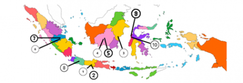
Figure 1. The distribution of research locations represents western Indonesia, eastern Indonesia, and central Indonesia
Table 1. Research location
|
No |
Village |
District |
Regency |
Province |
|
1 |
Pancarejo |
Semanu |
Gunungkidul |
D.I. Yogyakarta |
|
2 |
Jepitu |
Girisubo |
Gunungkidul |
D.I. Yogyakarta |
|
3 |
Semuntai |
Long Ikis |
Paser |
Kalimantan Timur |
|
4 |
Karang Sari |
Parenggean |
Waringin Timur |
Kalimantan Tengah |
|
5 |
Karang Tunggal |
Parenggean |
Waringin Timur |
Kalimantan Tengah |
|
6 |
Teriti |
Sumay |
Tebo |
Jambi |
|
7 |
Muara Kilis |
Tebo Ilir |
Tebo |
Jambi |
|
8 |
Cibeusi |
Ciater |
Subang |
Jawa Barat |
|
9 |
Benggaulu |
Dapurang |
Pasangkayu |
Sulawesi Barat |
|
10 |
Bulu Bonggu |
Dapurang |
Pasangkayu |
Sulawesi Barat |
The type of data to be collected consists of secondary data and primary data. Secondary data is obtained from official report documents of village government, district/city and provincial governments, and relevant official documents. Secondary data collection techniques are done by accessing documents online (browsing documents through official websites or search engines) or offline (copying documents, requesting printed documents directly). Meanwhile, primary data were obtained from direct sources from the informants of this study. The informants of this research will be interviewed using in-depth interviews and FGD methods. In addition, direct observations were made of the research location. The informants of this research consisted of several parties, including the Village Head, Head of BPD, Village Apparatus, Village Leaders, Village Community, and Regency Government.
The primary criteria being villages that have developed and implemented the Village Spatial Plan (RTRDes) within their communities. As there's no comprehensive data on the number of villages that have compiled RTRDes in Indonesia, these criteria were vital in the selection process. The study obtained location data from the partner program of the Kehati Foundation, considering that these locations could represent several significant provinces in Indonesia. Ten villages were selected as research locations, all of which have potential closely related to environmental issues and village economic development. The details of the research locations are as follows (Table 1 & Figure 1).
After data collection, the research phase continued with data analysis. Data analysis used a qualitative approach to parse the meaning of the collected data into findings. Creswell describes the data analysis process as spiral-like contours, indicating that the researcher immerses themselves in the analysis stage [45]. The stages of data analysis consist of managing and organizing data, reading and memoing emerging ideas, describing and classifying codes into themes, developing and assessing interpretations, and representing and visualizing the data.
4.1 Village motives for developing RTRDes
The results of data collection from ten research locus villages found a number of the main motives of the village in preparing the RRTDes. Each village has a different motive, adjusting to the problems they want to solve, which then become targets in their village development plans. These motives include: Desa Pacarejo: sebagai upaya melakukan mitigasi bencana;
(a) Jepitu Village: for equitable distribution of community welfare by optimizing the main potential of agricultural and tourism villages;
(b) Semuntai Village: to make it easier to map protected areas amidst the dominance of oil palm plantations;
(c) Karang Sari Village and Karang Tunggal Village: to optimize the potential of superior commodities in the village, map the village administration area and resolve the status of village areas located in forest areas;
(d) Teriti and Muara Kilis villages: to determine village boundaries and village land ownership so that there are no conflicts or disputes over land use;
(e) Cibeusi Village: to develop nature conservation in order to restore and maintain clean water sources because it is a water buffer area;
(f) Benggaulu Village and Bulu Bonggu Village: for solving regional problems where the location of this village is directly adjacent to a protected forest area, limited production forest, and oil palm companies. In addition to optimizing the village's potential to improve the community's welfare.
4.2 Process of compiling RTRDes
The study results found that preparing the RTRDes in the Village was due to the principles of the parties involved. The principles in the preparation of the RTRDes in the Village include: 1) Participatory, which involves the local community in the drafting process; 2) Accountability, the existence of information disclosure for all parties involved; and 3) Bottom-up, starting from the village level meeting to determining the results.
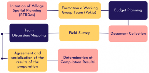
The process of preparing the Village Spatial Plan (RTRDes) was generally similar across the ten research locus villages, with differences primarily in the level and form of community participation involved in compiling the RTRDes. Meanwhile, the average preparation time and costs were roughly the same, typically spanning 3-6 months with a cost ranging from 30 million to hundreds of millions of Rupiah. This information was shared by external village parties involved in the process of preparing the RTRDes. The stages of the process are as follows (Figure 2).
Figure 2. Stages of preparation of the village spatial plan
Source: Data has been processed by the authors
At the beginning of the preparation, the village received assistance and support from outside parties. At the initiation stage, there is a process of coordination, socialization, and internalization of understanding related to the substance to be planned for the preparation of the RTRDes. Then a Village Deliberation (Musdes) was held, followed by the community forming a Working Group (Pokja) to prepare the RTRDes. The formation of the Pokja consists of elements of the village apparatus and society. The team developed consists of the Supervisory Team and the Technical Teams. The Supervisory Team comprises representatives of the Village Apparatus (Village Head and Head of the Village Consultative Body), Community Leaders, Youth Leaders, Traditional Leaders, Religious Leaders, and representatives from women's and farmer groups. While the Technical Team consists of representatives of the Village Apparatus (Village Secretary, Members of the Village Consultative Body, Head of Village Affairs, Head of Dusun) and Community Leaders. The selection of this technical team took into account the understanding of the spatial conditions of the village.
Budget planning is essential in preparing the RTRDes because the most significant cost component is the cost of preparing the map. That depends on its conformity with the standard for compiling maps and the village size—the more detailed the map, the greater the cost. Meanwhile, in the document collection, documents related to village territory in the past were the most needed documents in drafting the RTRDes. At the village field survey stage, data collection and mapping of village conditions were carried out manually and using drones. In this activity, all teams share roles, including community support. Tracking several locations on the map is carried out by the community and external counterparts.
After the survey was carried out, the team analyzed map data with the village community; the discussion discussed, among other things, determining village boundary points, determining areas, processing drone data, verifying field results, and preparing programs or activities for the realization of the RTRDes. The preparation results are compiled in one document, then disseminated to the village community, plantation companies in the village, local government, and others. Furthermore, the results are drafted/drafted Village Regulations to be ratified. While the determination of the results of the RTRDes is legalized through a Village Regulation through the following stages:
(a) Preparation of the Draft village rules for the Legal Department in the District;
(b) Reviewing the Village Plan and the Draft Village Planning Map document;
(c) Consultation with the Office in charge of regional spatial planning for synchronization with the applicable Regency RTRW;
(d) If there are no problems with the Regency RTRW, the village rules can be ratified as a legal product.
4.3 RTRDes supporting and inhibiting factors
There are supporting and inhibiting factors in preparing and implementing the RTRDes. The supporting and inhibiting factors at each stage of designing and implementing the RTRDes are identified as follows (Table 2).
Table 2. Supporting and inhibiting factors of RTRDes
|
Preparation of RTRDes |
Application of RTRDes |
||
|
Supporting Factors |
Obstacle Factor |
Supporting Factors |
Obstacle Factor |
|
Awareness of the Village Head and the community regarding village spatial planning. |
The lack and varying levels of knowledge related to spatial planning. |
The mandate of the Village Law regarding village authority in regulating village spatial planning. |
There is no legal basis for the Regional Government to evaluate and approve the issuance of Village Regulations regarding RTRDes. |
|
Assistance from outside the village. |
Meeting restrictions due to a pandemic situation. |
The RTRDes document that has been prepared is in sync with the Regency RTRW. |
Clarity of village units in the RTRDes by the Ministry of ATR/BPN. |
|
Village Government Facilitation. |
Villages still find it challenging to budget for Village Spatial Plans. |
The Village Head uses the RTRDes as one of the primary considerations in every planning. |
There is no legalization of RTRDes yet. |
|
Funding support from outside the village. |
There were protests and suspicions from neighboring villages. |
Public awareness of better use of space. |
Some parties have not followed the existing RTRDes. |
|
Local wisdom related to customary norms and agreements related to the territory of the Village. |
|
Government programs can be synchronized with RTRDes, such as aid distribution. |
The existence of a pandemic has not been optimal in directing development, according to the RTRDes. |
|
High level of community participation. |
|
There is a sustainable partnership between Village-Owned Enterprises and business actors in the Village. |
Using the village Fund Budget for handling the pandemic. |
|
Mapping technology support. |
|
|
|
Source: Data has been processed by the authors
The key to the village's success in preparing the RTRDes cannot be separated from the high level of community participation and substantial assistance in providing knowledge, advocacy, and funding. This assistance was obtained from external village parties who did understand the substance of spatial planning. These external parties include the Javlec Indonesia Foundation (Java Learning Centre), Kawal Borneo Community Foundation (KBCF), and the Sulawesi Community Foundation (SCF).
In the implementation of the RTRDes, there are obstacles to the legality of the RTRDes where there is no legal protection related to the preparation of the RTRDes. While the contextual RTRDes related to village spatial planning still need clarity from the Ministry of ATR because of the consequences of the stipulation of RTRDes at the village level, all business applications in the village need permission from the village.
4.3 Benefits of RTRDes for villages
The study results show that the RTRDes is beneficial in 3 (three) types of benefits for the village, including social, economic, and environmental benefits (Table 3).
Table 3. Benefits of RTRDes
|
Social Benefits |
Economic Benefits |
Environmental Benefits |
|
Increase community participation in village development planning |
A critical, sure, and exciting source of information for investors who are interested in investing in villages |
Villages have a mapping of administrative areas regularly and can continue to be updated (updating) |
|
Resolving conflicts over the use of village space or land use in the village area |
Become an instrument of protection/control or consideration in the selection of investments that enter the village |
Increase public awareness of the village space, which is the control in protecting the village area |
|
Maintaining the local wisdom of the village community |
Support the development of the village's leading commodity potential |
Maintaining a sustainable environment |
|
|
Facilitate the village in planning village development programs/activities |
Handling environmental issues |
|
|
|
Become the basis of reference in the review of the Regency RTRW |
Source: Data has been processed by the authors
4.4 RTRDes implementation for sustainable village development
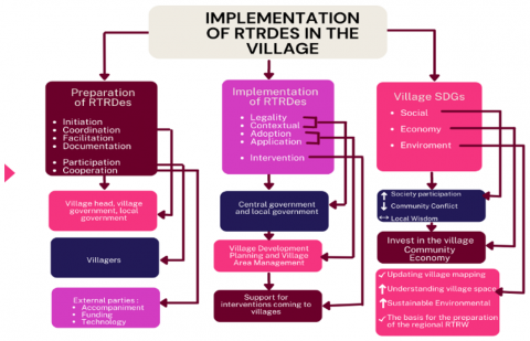
Based on the positive benefits that are felt because of the existence of RRTDes in the village, the RRTDes are very important to realize village progress. The researcher analyzed the preparation to implementation process to get an overview of the RTRDes implementation process for sustainable village development (Figure 3).
Figure 3. Implementation of RTRDes in the village
Source: Data has been processed by the authors
In the process of drafting, mentoring plays an important role, especially assistance from parties outside the village who understand the substance or how to prepare the RTRDes. There are still many human resources in the village who do not understand how to make maps and others, so the role of external parties is significant in this preparation process. Then the preparation process will not be successful without facilitation from the village government. The village government, aware of the importance of the RTRDes for their village, will fully support the drafting process physically and non-physically. In preparing the RTRDes, coordination with various parties is needed for the results of the RTRDes that are useful and do not cause conflicts in the future. Coordination can be with local governments, neighboring villages, and others.
The results of the preparation of the RTRDes need legal legalization; it can be used as a guide and reference for the village. This legalization requires the role of the central government and local governments in issuing regulations and policies related to the preparation of the RTRDes. The impact of the RTRDes will be felt when the village begins developing a development plan. The RPJMDes becomes the basis for adoption and application in preparing the RPJMDes. Villages can find out a portrait of the condition of their village as a whole through the RTRDes so that planning related to social, economic, and environmental can be achieved by the village and accelerate the village to achieve the SDG's Village targets.
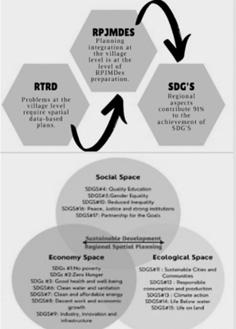
Although the legal aspect of the term village spatial planning is weak, its fundamentality aspect is essential and exciting to study. Moreover, there is a direction of village development towards achieving sustainable development. Improving village space is increasingly relevant to achieving the SDG, the national village development target. Eleven (11) SDG goals are closely related to village territory (goals 7-17), so village actions on regional aspects contribute 91 percent to the achievement of the national SDGs. Therefore, village spatial planning policy issues and agendas become very important and urgent as the basis for preparing the Village Medium Term Development Plan (RPJM Des) (Figure 4).
Figure 4. RTRDes realize SDGs village
Source: Analysis by the author and guidelines for compiling village land use plan documents (2020) [46]
It is Village spatial planning was first mandated in Article 84 Paragraph (1) of Law No. 6 of 2014 [34] concerning Villages. The relevant context in this norm is that the development of rural areas by the government, local governments (province/district/city), and third parties who utilize village spatial planning must involve the village government. It is just that the term village spatial planning is not followed up by technical regulations derived from the Village Law, even the concept of village spatial planning does not exist in other technical legislation. Meanwhile, traced to a special regulation that regulates spatial planning, the Spatial Planning Law [47], the term village spatial planning does not exist. Even this regulation does not recognize the village concept, so the village does not exist in the spatial arrangement.
The mandate of the Village Law Number 6 of 2014 [34] concerning Villages in conjunction with Article 8 of the Regulation of the Minister of Villages, Development of Disadvantaged Regions, and Transmigration Number 1 of 2015 [35] concerning Guidelines for Authority Based on Origin Rights and Village-Scale Local Authorities explains that villages have the authority to regulate their spatial planning based on rights of origin and local authority on a village scale [48]. The authority over the right of origin has the meaning, among others, related to asset management in the village area. The Village Law uses two development approaches, namely "Developing Villages" and "Developing Villages," and placing villages in their nature as inclusive and not exclusive communities [16, 49]. Since the existence of the Village Law, a village is no longer only an object of development but a subject of development so that the village itself can plan and create programs for its village, besides that the village can also manage its budget for development carried out in its village [16].
It has been applied by the ten loci of this research village. These villages have carried out the preparation for the implementation of the RTRDes. Awareness of spatial sovereignty can be used as a guide in long-term development, making these villages enthusiastic in preparing the RTRDes. The motive of the village in compiling the RTRDes is that the community hopes that life will lead to prosperity, so they try to make improvements in the development process. It is because the current position of the village is very strategic in building a country; the village is at the forefront of identifying problems and community needs at the grassroots level until the planning and realization of state goals are at the village level [50].
5.1 How RTRDEs work as a village development plan?
In preparing the RTRDes, there are principles in line with planned village development where the village government and all elements of society must be involved in the development planning process to obtain effective results [51]. In the process of preparing the RTRDes in the initiation stage of the preparation of the supporting factors identified are the community's aspirations that require arrangements related to spatial planning in the village. The role of the Village Head is also critical in initiating this arrangement, especially in increasing public awareness and encouraging community participation to play an active role in development. In addition, there is support and assistance from external village parties; this is what is needed by the village where the village does not have many human resources who understand the preparation of the RTRDes. Most people do not understand their village's spatial conditions, potential, and boundaries of all the research.
Assistance is available due to a cooperation agreement between the district government and external parties related to two main activities: mapping village boundaries and collecting data on the village's superior potential. The assistance from external parties includes understanding the definition and function of spatial planning, providing training in data collection and presentation activities, reading and understanding maps or satellite data, and increasing the human resources capacity to develop integrated village areas. External parties also finance the process of preparing the RTRDes. Funding in preparing the RTRDes is one of the most important things because the costs are not cheap. In addition to financial support from external parties, villages also received assistance in the form of land cover satellite maps by submitting cooperation in submitting map requests such as to LAPAN and PUPR through Bappeda. So that the budget can be cheaper and use an excellent high-level satellite image map, it can be more strategic and a solution for compiling the RTRDes. The existence of technology also facilitates the preparation of RTRDes. In field survey activities, drone technology is beneficial for data collection for villages that do not have a large village land area.
5.2 The three benefits of RTRDes related to sustainable development
Although in determining the RTRDes, there are still obstacles to legality, these villages have felt the benefits of the existence of the RTRDes document. The three benefits of RTRDes related to sustainable development are social, economic, and environmental. First, perceived social benefits include increased community participation in village development planning activities. Before the RTRDes, community participation in village development planning activities was relatively low [16]. It is because, in development planning, the community has not been inclusively involved [52]. After the RTRDes came up with many community initiatives and ideas in development planning. Village development planning is essential because it is the starting point for determining the direction of village development. Without good planning, the village will not progress. Village development is an effort to achieve a prosperous village community through fulfilling basic social needs and optimizing village potential for the local economy and sustainable use of the environment [53].
In addition, the perceived social benefits of the existence of the RTRDes are reducing the potential for conflicts in the use of village space/village territories. Settlement of village boundary conflicts, maintaining land use according to its function, and avoiding conflicts of interest of leaders or conflicts over territory in a rural area. RTRDes also gives village communities bargaining power in resolving land management conflicts with private companies. Another social benefits RTRDes maintains are the local wisdom of the village community. Local wisdom on land ownership loyalty is still very high in some villages.
Second, the economic benefits felt after the existence of the RTRDes are that the RTRDes attract and increase the interest of investors to enter the village, as well as protection/control considerations in the selection of investments that enter the village. RTRDes also provide a comprehensive picture of the condition and potential of the village so that it can be a picture for investors who will invest in the village. RTRDes also supports the community's economy by developing the village's leading commodity potential. RTRDes is very useful to support the village's leading commodities, one of which is oil palm. For palm oil management communities, RTRDes makes it easy for them to achieve certifications such as the Roundtable on Sustainable Palm Oil (RSPO), Indonesian Sustainable Palm Oil (ISPO), issuance of Certificates of Cultivation Registration (STDB) for Oil Palm Plantations, as well as assistance in receiving other assistance programs for oil palm plantations.
RTRDes are also easier to use for the operationalization level to prepare village development programs because they have more complex objects for operations than broader objects. RTRDes assists in the number of village funds for villages because one of the indicators for determining the number of village funds is a village map that explains the village area. RTRDes are also a guide for infrastructure development in villages, especially in supporting land designated for cultivation or protected areas. RTRDes also assists the community and the Village Government in preparing village development programs, which have adapted to the spatial conditions and characteristics of village land and the local community's needs. So far, village development planning has not been optimal due to not paying careful attention to spatial aspects [16]. Community program proposals in village deliberations are not spatially based, so the proposal does not match the actual conditions in the field; besides that, the program proposal is also not accompanied by coordinate points that can facilitate the identification of the feasibility of implementing the program. However, the implementation of village development is a process that must be improved continuously, starting with planning, organizing, mobilizing, and controlling [16].
Third, environmental benefits have the most impact from the existence of the RTRDes. The village has an updated administrative area mapping. The existence of RTRDes supports the realization of village boundaries. It shows that the RTRDes activities also provide benefits to the Village Government in updating village data for the local village development capital. In addition, they are increasing public understanding of the use of village space and control in protecting the village area. So far, the community only knows about the land they own. However, preparing the RTRDes opens their minds and increases public knowledge about spatial planning, especially the assistance provided by parties with the capacity and competence in this field.
The community is the holder of the implementation control related to the RTRDes, where the community is more aware of the area of the village and the current boundaries of the village. The existence of RTRDes provides the ability to maintain a sustainable environment. By mapping the potential of the protected area, it can improve the management of the protected area, which is regulated by village regulations—maintaining a sustainable paddy field zone from the potential conversion of land into oil palm plantations. In addition, the RTRDes protects riverbanks from development activities for oil palm and other commodities. Environmental issues in the village can handle because the village has information such as rainfall, land slope, and disaster-prone areas. So that disaster-prone protection can be done. The RTRDes become the basis of reference in the review of the Regency RTRW. The results of discussions with local governments at several research loci, especially with the District Public Works and Spatial Planning Office, welcomed the preparation of the RTRDes document because it supported their work. Especially in the context of realizing a more precise and more detailed Regional Spatial Plan, it is currently still in the verification stage.
5.3 Stakeholder roles and authorities in RTRDes
In the implementation of the RTRDes, at the preparation stage, several actions are needed to support the drafting process, including participation, assistance, facilitation, and coordination. Participation from the community is essential because it is the community who knows the history of their village land and the community's involvement to avoid further land conflicts. There are various forms of community participation; when referring to Mulyadi [54] community participation in the RTRDes divide into 4 (four) forms, including participation in decision making, participation in implementation, participation in benefits, and participation in evaluation. Participation in decision-making is indicated by community participation in attending RTRDes drafting meetings, expressing opinions or suggestions in every meeting/meeting, providing data/information in every RTRDes meeting/meeting, and community participation in the decision-making process/formulation. Then the form of participation in implementation includes community contributions in the form of labor and materials, especially when conducting field survey activities. At the same time, the form of participation in benefit includes the community participating in activities that support development in the village. For participation in the evaluation, the community provides suggestions and input on the development course, provides an assessment, and submits it as evaluation material.
In the end, massive village development was carried out. Villages are the subject of development actors because they hold the authority and financial resources. The slogan for the village to build is carried out every year. On the other hand, the village supra-village did not stop the "old hobby" of making the village a "development project market. "This supra-village party can be the government and local government (province/district/city) and the private sector, whose enthusiasm is to take advantage of village resources. The eight-year era of the Village Law has made us all aware that massive village development requires well-planned, comprehensive, and sustainable control. The scope of controlling the direction of village development policies already exists in the Village Regulation concerning the Village RPJM. Even now, through Permendesa No. 21 of 2020 [55], the Village Minister has set the Village SDGs as a policy direction for village development. However, regulatory orders are not always carried out perpendicularly in the field. Many original Village RPJM documents, even making the Village SDGs the direction of village development, are still far from expectations.
Control over the use and utilization of village space requires comprehensive village spatial planning and land use documents. This collaborative research related to the RTRDes found a similar pattern, the practice of preparing the RTRDes on the initiative outside the village. The initiative invites the village to be aware of space and have a spatial vision in village development. In a joint reflection between internal village parties, it was revealed that the process and results of the preparation of the RTRDes made them aware of the importance of spatial structures and patterns in the village. They also assessed that the village government's participation and accountability had, on average, improved with the existence of the RTRDes document.
All district governments studied appreciated the initiative of the village and its partners in preparing the RTRDes. The OPD in charge of the village (government, development, social community, community empowerment) is aware of this initiative but has not been able to take further formal legal action. Indeed, exceptional cases occurred in Paser Regency, East Kalimantan and Sigi Regency, and Pasangkayu Regency, West Sulawesi. After reviewing the Raperdes RTRDes, the three regencies passed the Village Regulations concerning the RTRDes. Meanwhile, other district governments have not dared to provide recommendations on the results of the Raperdes review to become the Village Regulations of the RTRDes. The reasons for the anomaly that occurred in Paser Regency cannot be known in detail by the Paser Regency government; they tend to provide unclear information about the process and arguments for the passage of the Semuntai Village RTRDes Village Regulation Draft. Meanwhile, according to counterparts in Kalimantan, in principle, the regional government (legal department) passes the Village Regulation Plan because its substance and legal aspects do not violate the provisions of the laws and regulations above it, for example; RTRDes are in sync with RTRW and RDTR.
Although three districts have passed the Raperdes RTRDes, legally, the protective law that guides the Raperdes RTRDes is not found in technical regulations derived from the Village Law or Spatial Planning Law. The lesson for district governments is to examine village spatial planning or land use more broadly and in detail. The absence of protective laws in the form of derivative technical regulations should guide local government organizations (OPD) in charge of villages to optimize the stages and processes of preparing the village's medium-term development plan (RPJM Desa). So that there is no double document in planning between the RTRDes document and the RPJM Desa document because both are integrated.
The ministry that manages the village so far has not guided the village in preparing village spatial plans. The same goes for the ministry in charge of spatial planning (Ministry of ATR/BPN). As a result, the national spatial vision in the context of national development planning (RPJPN, RPJMN, other documents) is not reflected in the spatial vision of the village in regional development planning documents (province, district) and village development planning (RPJM Desa). The national spatial vision is ultimately not in favor of the village, so it is often found in one village area that has overlapping land tenure statuses (state, private, village, indigenous peoples). An important lesson from the village initiative that developed the RTRDes was to make the issue of village spatial planning or land use a national policy agenda across ministries/state institutions (Kemendesa PDTT, Ministry of Home Affairs, Ministry of ATR/BPN, Bappenas, BIG).
The motive for the village to prepare the RTRDes is to solve problems and protect the environment in the village. The substance of the preparation of the RTRDes provides direct benefits to multiple village parties. The stages and processes carried out in a participatory manner provide critical awareness and learning for village stakeholders that village spatial sovereignty must be realized through the preparation of the RTRDes to increase community participation and accountability in village development planning. The urgency of the preparation and implementation of the RTRDes is to help advance the village because the village has more direction in village development planning according to the structure and pattern of village space for sustainable livelihoods. The existence of RTRDes provides economic, social, and environmental benefits. RTRDes has also become a new entity in improving the village economy according to its potential. It aligns with the direction of village development to achieve the SDG's Desa goals.
Recommendations from this research include that the legal protection that overshadows the preparation of the RTRDes is still weak. Legal certainty related to RTRDes is needed as a foothold and guide for village development. The arrangement of village spatial plans has been mandated in the Village Law. However, there has been no regulation or derivative policy as a technical guide in preparing village spatial plans. Successful Village Law implementation requires support from all parties [56]. There is a need for coordination and synergy between Ministries/Institutions related to policy guidelines for preparing the RTRDes. In addition, it is essential to have guidelines for integrating the preparation of the RPJMDes into the process of preparing the RPJMDes. Stakeholders in the village must participate in realizing a sovereign village space.
The limitation of this study is that there is no location of indigenous villages that are sampled in this study. It is hoped that further research will be carried out on indigenous villages so that they can complement the results of this research as policy material in village spatial planning.
The author would like to send biggest gratitude to the Village’s Government locus whose grant permission to conduct this research. Also, we like to say thank you to the informants who are willing to provide data and information for this research. Thank you to the Yayasan Kehati Indonesia and Ministry of Village (MoV) for the fasilitation support during research activities.
[1] Mozaffari, A., Barry, J. (2022). Heritage and territorial disputes in the Armenia–Azerbaijan conflict: A comparative analysis of the carpet museums of Baku and Shusha. International Journal of Heritage Studies, 28(3): 318-340. https://doi.org/10.1080/13527258.2021.1993965
[2] Kuo, J., Huang, M.H., Chu, Y.H. (2022). Maritime territorial disputes and China’s soft power in East Asia. Journal of Contemporary China, 31(133): 72-85. https://dx.doi.org/10.1080/10670564.2021.1926092
[3] Henrikson, A. (2022). The trauma of territorial break-up: The Russia-Ukraine conflict and its international management–geopolitical strategy and diplomatic therapy. Geopolítica (s), 13(1): 11-36. https://dx.doi.org/10.5209/geop.81880
[4] Ge, D., Zhou, G., Qiao, W., Yang, M. (2020). Land use transition and rural spatial governance: Mechanism, framework and perspectives. Journal of Geographical Sciences, 30: 1325-1340. https://doi.org/10.1007/s11442-020-1784-x
[5] Punta Yoga, A. (2022). The existence of the principles of sustainable development in recognition and respect of village interests in the national strategic project (Study case of wadas village conflict). Indonesian Advocate Journal, 1(1): 1-22. https://doi.org/10.52249/jai.v1i1.1
[6] Agustina, R. (2021). Village potential-based village spatial planning for directional and sustainable village development control. Journal of Regional and Rural Development Planning, 5(1): 15-27.
[7] Mudimu, G.T., Zuo, T., Nalwimba, N. (2022). Inside an enclave: the dynamics of capitalism and rural politics in a post-land reform context. The Journal of Peasant Studies, 49(1): 101-128. https://doi.org/10.1080/03066150.2020.1722106
[8] Filus, V., de Souza Lima, R. (2022). Contemporary capitalism and the “resistance social networks” of the Brazilian countryside. Research, Society and Development, 11(6): e32211629182-e32211629182. http://dx.doi.org/10.33448/rsd-v11i6.29182
[9] Batubara, B., Kooy, M., Leynseele, Y.V., Zwarteveen, M., Ujianto, A. (2022). Urbanization in (post-) New Order Indonesia: Connecting unevenness in the city with that in the countryside. The Journal of Peasant Studies, 1-20. https://doi.org/10.1080/03066150.2021.2000399
[10] Omar, N. (2019). Village Development in a Sociohistorical Perspective. Makassar: Equator.
[11] Iskandar, A.H. (2020). Village SDGs to accelerate the achievement of sustainable national development goals. Jakarta: Obor Indonesia Foundation.
[12] UN. (2015). Transforming our world: The 2030 agenda for sustainable development. New York: UN.
[13] Aminata, J., Nusantara, D.I.K., Susilowati, I. (2022). The analysis of inclusive green growth in Indonesia. Jurnal Ekonomi & Studi Pembangunan, 23(1): 140-156. https://doi.org/10.18196/jesp.v23i1.13811
[14] Cressendo, H. (2022). Environmental ethics in sustainable development. International Journal of Development and Public Policy, 2(5): 55-59.
[15] Qodriyatun, S.N. (2020). Flood disaster: Supervision and control of spatial utilization based on the spatial planning law and the job creation bill. Journal of Social Issues, 11(1): 29-42. https://doi.org/10.46807/aspiration.v11i1.1590
[16] Sirajuddin, T. (2020). Rural development strategies in Indonesia: Managing villages to achieve sustainable development. In IOP Conference Series: Earth and Environmental Science, 447(1): 012066. https://doi.org/10.1088/1755-1315/447/1/012066
[17] Khairiyyah, A., Amir, L. (2022). Implementation of city spatial arrangements through the application of building permits in the city of Jambi. Journal of Administrative Law, 3(1): 27-39. https://doi.org/10.22437/mendapo.v3i1.11464
[18] Kusriyah, S. (2021). Spatial and planning as a basis for development implementation in Indonesia. International Conference and Call for Paper Legal Reform on Corporate Responsibility in the Disruption Era, 4(4): 20779. http://dx.doi.org/10.26532/pdih.v4i4.20779
[19] Rustiadi, E., Veriasa, T.O. (2022). Towards inclusive Indonesian forestry: An overview of a spatial planning and agrarian perspective. Jurnal Manajemen Hutan Tropika, 28(1): 60-71. https://doi.org/10.7226/jtfm.28.1.60
[20] Hu, X., Li, H., Zhang, X., Chen, X., Yuan, Y. (2019). Multi-dimensionality and the totality of rural spatial restructuring from the perspective of the rural space system: A case study of traditional villages in the ancient Huizhou region, China. Habitat International, 94: 102062. https://doi.org/10.1016/j.habitatint.2019.102062
[21] Dilahur. (1994). Village geography and definition of village. Geography Forum, 14,15(VIII): 119-128.
[22] Pramaresti, E.W. (2019). Three types of traditional village spatial planning in South Nias, North Sumatra. Kalpataru, Archaeology Magazine, 28(2): 45-60.
[23] Atmaja, D.M. (2015). Spatial management based on local wisdom in the panglipuran indigenous peoples of bangli regency. Journal of Ecosciences, VII(1): 15-25.
[24] Zubaidah, S., Zamhari, A. (2017). The value of harmony in the spatial pattern of Pelang Kenidai village, Dempo Tengah district, Pagaralam city as a source of history learning. Kronik: Journal of History Education and Historiography, 1(1).
[25] Saptari, L.A., Arba., Putro, W.D. (2020). The existence of village spatial planning within the legal framework of development planning arrangements in east Lombok district. Jurnal Education and Development, 8(4): 688-694.
[26] Femilia, Y., Huda, U. (2020). Village authority in spatial planning based on village law. Adliya, Journal of Law and Humanity, 14(1): 121-140.
[27] Takwim, S. (2021). Spatial policy based on actor inclusiveness. Government: Journal of Government Science, 4(2): 97-103.
[28] Rohiani, A. (2021). Village spatial planning based on village potential as a directed and sustainable village development control. Journal of Regional and Rural Development Planning, 5(1): 15-27. http://dx.doi.org/10.29244/jp2wd.2021.5.1.15-27
[29] Riza, F. (2017). Legal review of the urgency of village spatial arrangements. Journal of Nestor Master of Law, 2(2): 210236.
[30] Bawono, R.I., Setyadi, E. (2019). Optimizing Village Potential in Indonesia. Gramedia Kompas. https://doi.org/57.19.4.0034.
[31] Bintarto, R. (2010). City Village. Alumni.
[32] Hanif, N. (2011). Growth and Implementation of Village Governance. Erlangga.
[33] Widjaja, H. (2013). Administration of autonomy in Indonesia in the context of dissemination of law number 23 of 2014 concerning regional government. Rajagrafindo Persada.
[34] Law of the Republic of Indonesia Number 6 of 2014 concerning Villages.
[35] Regulation of the Minister of Villages, Development of Disadvantaged Regions and Transmigration Number 1 of 2015 concerning Guidelines for Authorities Based on Origin Rights and Village-Scale Local Authorities.
[36] Rosidin, U. (2019). Village empowerment in the regional government system. Bandung: Pustaka Setia CV.
[37] Femilia, Y., Huda, U. (2020). Village authority in spatial planning based on the village law. Adliya, Journal of Law and Humanity, 14(1): 121-140.
[38] Law of the Republic of Indonesia Number 12 of 2011 concerning the Establishment of Laws and Regulations.
[39] Regulation of the Minister of Home Affairs Number 51 of 2007 concerning Development of Community-Based Rural Areas.
[40] Regulation of the Minister of Home Affairs Number 114 of 2014 concerning Guidelines for Village Development.
[41] Riza, F. (2017). Legal review regarding the urgency of village spatial arrangements. Journal of Nestor Master of Laws, 2(2): 210236.
[42] Puji, R.T. (2010). Village-city series encyclopedia. Semarang: Aneka Ilmu.
[43] Zaini, M., Darmawanto, A.T. (2015). Implementation of environmentally friendly sustainable development studies in lempake village, north samarinda district, samarinda city [Implementasi Pembangunan Berkelanjutan Berwawasan Lingkungan Studi Pada Kelurahan Lempake Kecamatan Samarinda Utara Kota Samarinda]. Jurnal Ilmu Ekonomi dan Pembangunan, 15(2): 24-31. https://doi.org/10.20961/jiep.v15i2.9904
[44] Flick, U. (1998). An Introduction to Qualitative Research. London: Sage Publications.
[45] Creswell, J.W., Poth, C.N. (2017). Qualitative inquiry and research design: Choosing among five approaches. London: SAGE Publications.
[46] Guidelines for Compiling Village Land Use Plan Documents. (2020). Yogyakarta: Javlec Indonesia.
[47] Law of the Republic of Indonesia Number 26 of 2007 concerning Spatial Planning.
[48] Zamroni, S. (2016). Villages Build without leaving suburban groups. Institute for Research and Empowerment (IRE), 2(1): 1-10.
[49] Herman, R. (2015). Villages within the framework of the unitary state of the republic of Indonesia: Viewing villages from the perspective of legislation. Journal of Decentralization, 13(1): 61-75.
[50] Sidik. (2015). Exploring local potential to realize village independence. Journal of Public Policy & Administration, 19(2): 115-131.
[51] Nugroho, D.O., Hariani, D., Lestari, H. (2014). Strategic planning for village development in Pingit village, Rakit district, Banjarnegara regency. Journal of Public Policy and Management Review, 3(4). https://doi.org/10.14710/jppmr.v3i4
[52] Damayanti, R., Syarifuddin, S. (2020). The inclusiveness of community participation in village development planning in Indonesia. Development in Practice, 30(5): 624-634. https://doi.org/10.1080/09614524.2020.1752151
[53] Astika, A., Subawa, N. (2021). Evaluation of village development based on the developing village index. Muqoddimah Scientific Journal, 5(2): 223-232.
[54] Mulyadi, M. (2019). Community Participation in Village Development. Yogyakarta: Nadi Pustaka.
[55] Regulation of the Minister of Villages, Development of Disadvantaged Regions and Transmigration Number 21 of 2020 concerning General Guidelines for Village Development and Village Community Empowerment.
[56] Simangunsong, F., Wicaksono, S. (2017). Evaluation of village fund management in Yapen islands regency Papua province (Case study at Pasirputih village, south Yapen district). Journal of Social Science, 5(19): 250-269. https://doi.org/10.4236/jss.2017.59018