Yosephina Ohoiwutun![]()
© 2023 IIETA. This article is published by IIETA and is licensed under the CC BY 4.0 license (http://creativecommons.org/licenses/by/4.0/).
OPEN ACCESS
This study evaluates the approach to developing the border area between Indonesia and Papua New Guinea, with a focus on creating a model for sustainable development. Using a qualitative approach, data were collected through observation and interviews in the Skouw Border Area. Analysis reveals that government strategies for border development are predominantly infrastructure-focused, leaning more towards security aspects than community and environmental empowerment. Moreover, an investment-based approach is observed. However, current policies lack a clear, principal legal basis to integrate security, welfare, and environmental sustainability approaches. Therefore, the study suggests the need for a more balanced approach that also prioritizes regional economic development and environmental sustainability. Such an approach should involve collaborative principles between central and local governments.
development, public policy, evaluation
According to the Geospatial Information Agency, the Unitary State of the Republic of Indonesia (NKRI) is the world's largest archipelagic country, boasting over 17,000 islands as of 2021 [1]. The NKRI's maritime borders are shared with various countries, including Malaysia, Singapore, the Philippines, India, Thailand, Vietnam, Palau, Australia, Timor Leste, and Papua New Guinea. On land, it shares borders with Malaysia, Timor Leste, and Papua New Guinea. These borders span across 13 provinces and cover 39 regencies/cities [1]. To manage these strategic border areas, the government established the National Border Management Agency (BNPP), which aims to integrate security, welfare, and environmental sustainability within a development framework [1].
However, there are significant challenges to overcome, including low-quality human resources, high poverty rates, and inadequate basic infrastructure for drinking water, sanitation, and waste management [2]. These issues are particularly evident in the territory of the Republic of Indonesia (RI) bordering Papua New Guinea (PNG). This area, extending 820 km from Muara Tami District, Jayapura City, to the mouth of the Bensbach River, Merauke Regency, is marked by socio-economic infrastructural lag and limited access to transportation, which further exacerbates the low level of community welfare [3].
Despite being the largest sub-district in Jayapura City with an area of 626.7 km2, Muara Tami District has the smallest population [3]. This area, mostly forested, borders Papua New Guinea. Of the six villages in Muara Tami District, only one is categorized as a "Developed Village" with a Village Development Index (IDM) value of more than 0.7. The other villages have IDM values ranging from 0.6011 to 0.6992 [3].
The border areas, rich in forests, minerals, and fisheries, have significant economic potential [4]. This potential is further enhanced by the enactment of the RI-PNG international agreement, managed through the Joint Border Committee (JBC) [4]. The legal basis for this cooperation is the Presidential Regulation Number 76 of 2018 concerning the Ratification of the Basic Agreement between the Government of the Republic of Indonesia and the Government of Papua New Guinea concerning Border Arrangement [4].
The BNPP, established by Presidential Regulation Number 12 of 2010, is designed to focus, synchronize, and coordinate border management under one control [5]. The agency is responsible for developing border programs, determining budget requirements, coordinating implementation, and evaluating and supervising state border and border area management [5]. BNPP also prepares key management documents, including a Grand Design, Master Plan, and Action Plan for the Management of State Borders, which serve as a shared reference for stakeholders in border development [5].
The Jayapura City Government's general program for the 2019-2022 Regional Medium Term Development Plan (RPJMD) aims to optimize the Skouw Integrated State Cross-Border Post for border communities, focusing on equal distribution of access to public services and housing arrangements for these communities [5].
The management of border areas in Indonesia has long been a research topic, primarily due to social, economic, and welfare disparities in border communities [6]. Development policies have often overlooked these areas, prioritizing densely populated locations with easy access and potential [7]. In contrast, remote, isolated, and underdeveloped regions in border areas have received less priority [8]. Yet, these border areas are considered the country's outermost line of defense, and the approach taken typically addresses defense and security issues [8].
Table 1 below is an explanation of border regions in Indonesia. Then conical on the focus of this study is shown in Table 2 and Table 3.
Table 1. Border regions in Indonesia
|
Provinces |
Districts/Cities |
Border Countries |
|
West Kalimantan |
Sambas, Bengkayang, Sangau, Sintang, Kapuas Hulu |
Malaysia |
|
East Kalimantan |
West Kutai, Malinau, Nunukan |
|
|
North Sulawesi |
Sangihe Islands, Talaud Islands |
Philippines |
|
North Maluku |
Morotai |
|
|
Maluku |
Southwest Maluku, West Southeast Maluku, Aru Islands |
Australia |
|
Papua |
Merauke, Bovendigul, Bintang Mountains, Keerom, Keerom, Jayapura City, Supiori |
Papua New Guinea |
|
West Papua |
Raja Ampat |
|
|
Nanggroe Aceh Darussalam |
City of Sabang |
Malaysia |
|
North Sumatra |
Serdang Bedagai |
|
|
Riau |
Rokan Hilir, Bengkalis, Indragiri Hilir, Meranti Islands, Dumai City |
Malaysia and Singapore |
|
Riau |
Natuna Islands, Anambas Islands, Batam City, Bintan, Karimun |
|
|
East Nusa Tenggara |
Kupang, North Central Timor, Belu, Rote Ndao, Alor |
Timor Leste |
|
District (District) |
Capital District |
Area (km2) |
Number of Villages/Kelurahan |
Number of Population |
|
Muara Tami |
Skouw Mabo |
626.7 |
8 |
18,414 |
|
Abepura |
Kota Baru |
155.7 |
11 |
123,811 |
|
Heram |
Waena |
63.2 |
5 |
68,107 |
|
Jayapura Selatan |
Entrop |
43.4 |
7 |
100,181 |
|
Jayapura Utara |
Tanjung Ria |
51 |
8 |
93,491 |
|
Total |
940 |
39 |
404,004 |
|
Source: BPS Jayapura City (2022)
Table 3. Status of progress and independence of villages in Muara Tami District, City of Jayapura
|
Village |
Social Resilience Index |
Economic Resilience Index |
Environmental Resilience Index |
Village Development Index |
Status |
|
Holte kamp |
0.7200 |
0.4167 |
0.6667 |
0.6011 |
Developing |
|
Koya Tengah |
0.7143 |
0.5167 |
0.8667 |
0.6992 |
Developing |
|
Mosso |
0.6229 |
0.4000 |
1.0000 |
0.6743 |
Growing |
|
Skouw Mabo |
0.6686 |
0.6000 |
0.8000 |
0.6895 |
Growing |
|
Skouw Sae |
0.7829 |
0.4500 |
1.0000 |
0.7443 |
Forward |
|
Skouw Yambe |
0, 7771 |
0.4500 |
0.6667 |
0.6313 |
Developing |
Several previous studies have proposed recommendations for developing border areas, emphasizing the need to enhance the institutional capacity of Regional Governments [9, 10]. Coordinated efforts are needed to integrate development planning, regulations, institutions, and financing, involving the government, businesses, and local communities [11]. Wahyudi and Sari highlighted the significance of inter-regional cooperation in border areas [12], while Ma'rif focused on rural development in these regions [7]. Meanwhile, Rosliana and others concentrate on educational innovation and human resource development [13].
Despite these efforts, gaps remain in our understanding of the appropriate development approach to manage border areas. Therefore, this study's discussion is two-fold: firstly, it explores the approach to developing infrastructure in the Skouw Border Area, and secondly, it aims to derive an appropriate model that can be applied in border area development. The ultimate goal is to contribute to existing knowledge and provide practical solutions for improving welfare and development in these essential regions.
2.1 Border areas historically
The history of Indonesia's border areas is intricately connected to Dutch Colonial history. The phrase "Van Sabang to Merauke", coined in 1910, illustrates the process of establishing the Dutch East Indies, a modern yet colonial entity. The legal definition of border areas is provided in Law Number 43 of 2008, Article 1 point 6, defining the boundaries of the Indonesian state as those separating its sovereignty from other countries based on international law. These borders include land boundaries with Malaysia, Papua New Guinea, and Timor Leste, maritime boundaries with Malaysia, Papua New Guinea, Singapore, and Timor Leste, and air boundaries conforming to international law.
The process of boundary-making, as described by Jones, goes through four stages: allocation, delimitation, demarcation, and administration [14].
Good management of boundaries and border areas, according to boundary-making theory, means that administrative activities or border area development management can overlap with demarcation. This overlap is due to the often encountered constraints and dynamics in the field concerning economic, social, cultural, and political aspects. Consequently, segmentation often occurs, and administrative or management activities go hand in hand with implementing boundary confirmation in the field.
2.2 Conceptual framework
Indeed, previous research has proposed various theories and strategies to manage border areas, which can be classified as follows:
The challenges in Indonesia's border areas often stem from underdevelopment, security concerns, and the welfare of the local population. As the country has numerous land, sea, and air borders, it faces a diverse range of specific problems. Moreover, these border areas, being the outermost and most marginalized, tend to receive less attention than more centralized regions.
In terms of developing these border areas, Wu suggests three approaches [21]:
This study adopts two of these approaches: the infrastructure-based approach and the investment-based development approach. The combination of these two approaches aims to address the challenges faced by Indonesia's border areas effectively. This could lead to a more balanced and sustainable development model that considers not only infrastructure and investment but also the unique socio-economic and cultural contexts of these areas.
3.1 Design
This research employs a qualitative research design, with an emphasis on a case study approach. This methodology is chosen over other types of qualitative research as it is best suited to comprehensively, intensively, and naturalistically understand the intricacies of border area management.
A case study is a research method that involves the systematic collection of detailed information about a specific individual, social setting, event, or group. The aim is to gather enough data to allow the researcher to effectively understand how the subject operates or functions [22]. This approach enables a deep, holistic understanding of the issues at hand, making it particularly useful for exploring complex phenomena in their real-world contexts.
In the context of this research, the case study approach allows for an in-depth exploration of the management of border areas, taking into account their unique historical, socio-political, and geographical characteristics. It allows us to gain a nuanced understanding of the challenges and potential strategies for these regions, contributing valuable insights that can inform policy and practice.
3.2 Data source
The data for this study were collected through two primary techniques: observation and interviews. The primary data sources were obtained from observing the circumstances and conditions in the Skouw Border Area, as well as from conducting interviews with several informants involved in the implementation of the development policy for the Skouw Border Area in the Muara Tami District, Jayapura City.
In addition to these primary sources, this research also involved an extensive review of literature and documents related to the management of the Skouw Border Area. These secondary sources included textbooks, journal articles, laws and regulations, statistical reports, and other relevant documents. The careful examination of these materials provided context and additional insights into the management of the border area.
3.3 Research informants
In this study, informants were classified into three categories: policy makers, policy implementers, and target groups. Each policy-making actor has characteristics that demonstrate their influence in the policy-making process.
Table 4. Research informants
|
Name |
Name/ Position |
|
Ir. H. Rustan Saru, MM |
Deputy Mayor of Jayapura City |
|
Abisai Rollo, SH |
Chairman of the Jayapura City DPRD |
|
Matthew Pawara, S.Sos., M.Sc. |
Head of the Inter-State Border Section, Regional Secretariat of Jayapura City |
|
Meike E. Teurupun, SE, MM |
Head of Border Administration Subdivision |
3.4 Data analysis techniques
The analysis technique used in this study adapted the Huberman & Miles method, which consists of data reduction; this involves focusing, simplifying, and transforming raw data into a more manageable form [22]. The process of data reduction and transformation occurs throughout the research period. Subsequently, the reduced data is displayed in tables, pictures, summaries of various statements, phrases, or terms, and in groupings of the reduced and transformed data. These data displays assist the researcher in understanding and observing specific patterns in the data or determining what further analysis or action to take. The data display process is a key component of the analysis process. The final stage in the study of the research data involves drawing conclusions and verifying the data. This is achieved by using triangulation or eliminating the differences in the construction of reality that exist in the context of a study when collecting data about various events and relationships from multiple perspectives.
4.1 The general description of the research location
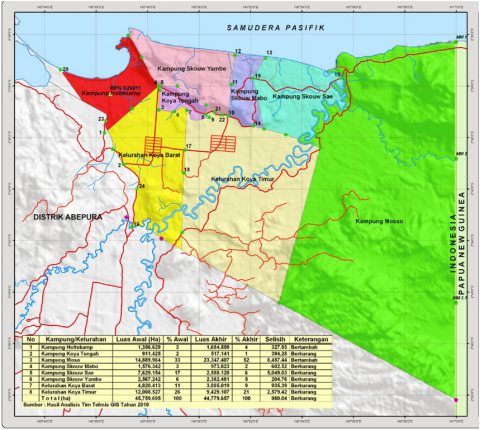
Figure 1. Map of Muara Tami District, Jayapura City
Source: https://pemerintahkelurahankoyabarat.blogspot.com/2012/01/peta.html
Based on the map shown in Figure 1, the Skouw Border Area is a part of the territory of the Republic of Indonesia (RI) sharing a land border with Papua New Guinea (PNG). The Skouw Cross-border Post (PLBN) is specifically located in Mosso Village, Muara Tami District, Jayapura City. This sub-district, covering an area of 626.7 km², includes six villages and two sub-districts.
The economic activities of the people in the Muara Tami District are generally still subsystems. A traditional market has been established in Skouw to facilitate the development of conventional cross-border trade. The economic function of cross-border activities is carried out to fulfill basic needs, institutional needs, and to symbolize citizenship [23].
4.2 Infrastructure-based development approach
This research aims to examine the current approach to border area development, based on the theory proposed by Wu, to understand how the development of border areas is appropriate for implementation in Muara Tami District, City of Jayapura [21].
Infrastructure development is a program of the Central Government aimed at accelerating development in the Skouw Border Area, as outlined in Presidential Instruction Number 1 of 2021 concerning the Acceleration of Economic Development in the State Border Areas.
Presidential Instruction Number 1 of 2021 is also addressed to the Mayor of Jayapura, instructing him to:
Infrastructure development is also a program of the Regional Government of Jayapura City, as outlined in the 2018-2022 Regional Medium Term Development Plan (RPJMD). The planned priority programs and development focus are expected to address disparities in society, such as the income gap between urban and rural areas, and development disparities between remote and border areas.
The acceleration of development in the Skouw Border Area in Muara Tami District, Jayapura City, has been temporarily implemented, as indicated by Presidential Instruction Number 1 of 2021 concerning the Acceleration of Economic Development in Border Areas in Aruk, Motaain, and Skouw. One part of the instruction was also addressed to the Regional Government of Jayapura City, directing them to: (1) provide ready-to-build land, (2) expedite the authorization process within their jurisdiction, and (3) allocate the necessary budget for program implementation by the relevant department or work unit. This task aligns with the vision and mission of the Jayapura City Regional Government as stated in the 2018-2022 RPJMD. The following in Table 5 explains the economic development program in the Skouw.
4.3 Achievements in the implementation of infrastructure development and future program plans
Following the conclusion of the 3rd period of the National RPJM (2015-2019), the 2015-2019 Master Plan for the Management of State Borders will also end. To support the 4th period of the National RPJM (2020-2024), BNPP prepared a Master Plan document for the Management of State Boundaries and Border Areas for 2020-2024. The program planning for 2020-2024 indeed takes into account the achievements of the previous master plan. Infrastructure development realized in the last period included the construction and meeting of 25 pillars (the MoU has not yet been signed) following the RI-PNG territorial boundaries. This is in line with the previous mission, namely:
Muara Tami District is one of the Priority Locations for the National Strategic Activity Center (PKSN). The infrastructure development programs and activities for the Skouw Border Area in Muara Tami District, Jayapura City, are displayed in Table 6.
Table 5. Economic development program in the Skouw
|
Agencies Implementor |
Program Activities |
Criteria and Description of Success |
|
Ministry of Agriculture |
Upgrading rice milling units |
Completed upgrading of rice milling units in West Koya and East Koya with a volume of 2 units. |
|
Construction of a rice warehouse |
Construction of a rice warehouse in West Koya with a volume of 1 unit. |
|
|
Construction of sago processing facilities and infrastructure in Skouw Yambe. |
Completion of construction of sago processing facilities and infrastructure in Skouw Yambe with a volume of 2 units. |
|
|
Development of Corn Product Processing Unit (UPH). |
Completion of construction of UPH Corn in Muara Tami District with 1 package volume. |
|
|
Procurement of hybrid rice seeds. |
Completed the procurement of Hybrid Rice seeds with a volume of 1 package. |
|
|
Ministry of Public Works and People's Housing |
Construction of inspection roads for border primary irrigation canals. |
The construction of an inspection road for the border primary irrigation canal in East Koya with a length of 2.4 km has been completed. |
|
Construction of boat moorings. |
Completion of the construction of a boat berth in Enggros with a volume of 10 units. |
|
|
Development of Drinking Water Supply System. |
Completion of SPAM construction in Muara Tami District with volume 1 package. |
|
|
Construction of the main road in Mosso Village, Keerom Regency (4.5 meters wide). |
The construction of the main road in Mosso Village, Keerom Regency (4.5 meters wide) in Mosso Village with a length of 30 km has been completed. |
|
|
Construction of a pier road in Enggros (3 meters wide) |
The construction of a pier road (3 meters wide) in Enggros with a length of 5 km has been completed. |
|
|
Increasing the capacity and quality of the provincial road connecting East Koya Sub-District – West Koya Sub-District (6 meters wide). |
Completion of increasing the capacity and quality of the provincial road connecting East Koya Village - West Koya Village (6 meters wide) with a volume of 1 package. |
|
|
Ministry of Maritime Affairs and Fisheries |
Rehabilitation of ponds for groups of cultivators |
Completed rehabilitation of ponds for groups of cultivators in Holtekamp Village with a volume of 1 package. |
|
Construction of fish ponds for cultivator groups |
Completion of construction of fish ponds for cultivator groups in Holtekamp Village with a volume of 1 package. |
|
|
Development of seed and feed cultivation facilities for cultivator groups |
Availability of construction of seed and feed cultivation facilities for cultivator groups in Holtekamp Village with volume packages. |
|
|
Ministry of Cooperatives and SMEs |
Revitalization of people's markets managed by cooperatives in border, underdeveloped and post-disaster areas. |
Completion of revitalization of people's markets managed by cooperatives in border, underdeveloped and post-disaster areas in Muara Tami District with volume 1 package. |
|
Ministry of Transportation |
Acceleration of the development and operation of the International Goods Terminal and Showcase in the Skouw PLBN area. |
Completion of the construction and operation of the International Goods Terminal and Showcase in the Skouw PLBN area with volume 1 package. |
|
Ministry of Energy and Mineral Resources |
Development of electricity distribution network in Muara Tami and Abepura Districts. |
Completion of the development of the electricity distribution network in Muara Tami and Abepura Districts with a volume of 1 package. |
|
Construction of gas stations in Skouw. |
Completion of gas station construction in Skouw with volume 1 package. |
|
|
Ministry of Communication and Informatics |
Development of internet access telecommunication networks and GSM. |
Completion of the development of internet access telecommunication networks and GSM in Kampung Mosso with volume 1 package. |
Source: Presidential Instructions No. 1 Tahun 2021
Table 6. Infrastructure development programs and activities Skouw border area
|
Programs/Activities |
Volume |
Implementation Timeline |
|
Development of the Integrated Cross-Border Post (PLBN) |
1 |
2015 |
|
Improvement of modern CIQS facilities and infrastructure (X-ray, metal detector, document scanner, etc. |
_ |
_ |
|
Country Cross-border Post |
1 |
2020 |
Source: BNPP document
Programs and activities implemented by the BNPP are expected to be able to develop the Skouw Border Area, as conveyed by the Deputy Mayor of Jayapura in the following interview on 7 August 2021:
“We received reports on programs and activities carried out by the BNPP, among others, remembers the program and activities for providing basic infrastructure facilities for electricity, clean water, fuel, telecommunications, provision of basic infrastructure facilities and infrastructure for the Muara Tami District border area.”
The Head of the Inter-State Border Section of the Regional Secretariat of Jayapura City expressed the following in an interview on 13 August 2021:
“The development program that already exists in the border area of Muara Tami District is being carried out by the National Agency for Border Management. This development is a development enhancement program for border areas. Which is a PKSN Priority Location, and the District is one of them. The program of infrastructure development activities is the provision of basic infrastructure facilities for electricity, clean water, fuel, telecommunications, provision of basic infrastructure facilities and infrastructure.”
Based on the information mentioned above, the development of the Skouw Border Area in the Muara Tami District, Jayapura City, is seen from the perspective of infrastructure development concerning the realization that the program already exists. It shows from the report of the BNPP to the Regional Government of Jayapura City, including the construction of basic infrastructure for electricity, clean water, fuel, and telecommunications.
An approach to developing the Skouw Border Area in Muara Tami District, Jayapura City, based on Investment in the Skouw Border Area, The Jayapura City Government, provides an opportunity for investors to invest in the Skouw Border Area, as stated by the Deputy Mayor of Jayapura City in an interview on 7 August 2021 as follows:
"The Jayapura City Government has provided opportunities for all investors who will invest in Jayapura City. This opportunity is provided in terms of providing incentives and facilitating investment, only given to new investors and investors who are expanding and promoting the bureaucracy in granting investment permits.”
The Chairperson of the Jayapura City DPRD also expressed the following in an interview on August 9, 2021:
"The Jayapura Regional People's Representative Council always reminds the Jayapura City Government to attract many investors to come to Jayapura City, how to carry out promotions and provide opportunities for every investor. so they want to come to Jayapura City.”
The Regional Government of Jayapura City can provide incentives and facilities to investors who wish to develop their business in the Skouw Border Area, per statutory provisions. Forms of incentives that Regional Governments can provide based on Government Regulation Number 45/2008 Article 3 include regional tax relief, regional levy relief, provision of simultaneous funds, and provision of capital assistance. Meanwhile, other forms of convenience that the Regional Government can provide are the provision of data and information on investment opportunities, provision of facilities and infrastructure, provision of land or locations, provision of technical assistance, and acceleration of licensing so, which should give the provision of incentives and ease of investment to new investors and investors who expand their business for development in border areas.
Based on the results, the approach to developing the Skouw Border Area in Muara Tami District, Jayapura City, has been institutional. The conclusions from the border area development approach, according to Wu's theory, are described as follows:
The model for border area development proposed by Wu does not appear to align with the realities on the ground [21]. The development approach for the Skouw Border Area focuses more on infrastructure development, while investment opportunities have not been able to aggressively stimulate business actors despite the facilities and opportunities provided. Therefore, this study proposes a border area approach model that prioritizes regional economic development from an environmental perspective. Moreover, the policy for the development of the Skouw Border Area must have a legal basis and principles directed toward security, welfare, and environmental sustainability. This implies that the support of the local community and government is needed in maintaining state sovereignty. These models are underpinned by the principle of prioritizing collaborative management. Collaborative management opens up opportunities for an effective policy agenda in the future, including determining long-term investment models aligned with sustainable development goals.
Despite the implications of this research, it still has limitations that need to be considered for future research developments. Issues related to problems in the border area and the policies that govern them are not explicitly discussed in this study. Future research is expected to expand the scope of the research area regarding the development of the RI-PNG Border Area to obtain more comprehensive benefits.
[1] Nasution, M.S. (2018). Strategic border area potential. Jurnal Kebijakan Publik, 9(2): 117-124. https://doi.org/10.31258/jkp.9.2.p.117-124
[2] Wahyudi, A., Sari, M.A. (2011). Inter-regional cooperation to improve regional development and public services in border areas. Jurnal Borneo Administrator, 7(3): 283-307. https://doi.org/10.24258/jba.v7i3.77
[3] Prasojo, Z.H. (2013). The dynamics of local communities at the border. Walisongo: Jurnal Penelitian Sosial Keagamaan, 21(2): 417-436. https://doi.org/10.21580/ws.2013.21.2.252
[4] Muta'ali, L., Marwasta, D., Christanto, J. (2014). Management of the NKRI Border Areas. Gadjah Mada University Press.
[5] Mangku, D.G.S. (2018). The role of the national border management agency (BNPP) in maintaining the territorial sovereignty of the unitary state of the Republic of Indonesia. Jurnal Ilmiah Ilmu Sosial, 4(2): 167-174. https://doi.org/10.23887/jiis.v4i2.16532
[6] Sudiar, S. (2017). Border development policy and community welfare in the border areas of Sebatik Island, Indonesia. Jurnal Paradigma, 1(3): 389-401. https://doi.org/10.30872/jp.v1i3.316
[7] Ma’rif, S. (2012). Strategi pengembangan perdesaan kawasan perbatasan, Studi kasus: Kawasan perbatasan Republik Indonesia-Ambenu Republik Demokratik Timor Leste. Tataloka, 14(1): 75-89. https://doi.org/10.14710/tataloka.14.1.75-89
[8] Akadol, J. (2012). Border development policy in Sambas District, West Kalimantan: Reality and expectations. Pandecta Research Law Journal, 7(1). https://doi.org/10.15294/pandecta.v7i1.2362
[9] Faozan, H. (2006). Strengthening the institutional capacity of local governments as the main agenda for optimizing the management of border areas. Journal Borneo Administrator, 2(2). https://doi.org/10.24258/jba.v2i2.19
[10] Marwasta, D. (2016). Assistance in the management of border areas in Indonesia: Lesson learned from KKN-PPM UGM in border areas. Jurnal Pengabdian kepada Masyarakat (Indonesian Journal of Community Engagement), 1(2): 204-216. https://doi.org/10.22146/jpkm.10607
[11] Permatasari, A. (2014). Special autonomy for border areas, Alternative solutions to solving border problems in Indonesia. Jurnal Media Hukum, 21(2): 16. https://doi.org/10.18196/jmh.v21i2.1189
[12] Wahyudi, A., Sari, M.A. (2011). Inter-regional cooperation to improve regional development and public services in border areas. Jurnal Borneo Administrator, 7(3): 283-307. https://doi.org/10.24258/jba.v7i3.77
[13] Rosliana, L., Fani Heru, W., Lutfie, W., Hidayah, K., Aziza, T.N. (2015). Border management focuses on educational innovation at the North Kalimantan Border. Jurnal Borneo Administrator, 11(3): 316-339. https://doi.org/10.24258/jba.v11i3.205
[14] Jones, S.B. (1945). Boundary-Making: A Handbook for Statesmen, Treaty Editors, and Boundary Commissioners. Carnegie Endowment for International Peace.
[15] Purnamasari, W., Kara, M.H., AR, M.S., Amiruddin, K. (2016). The development of economic development in the border region of Indonesia and Malaysia in Sambas. Jurnal Diskursus Islam, 4(2): 217-247. https://journal.uin-alauddin.ac.id/index.php/diskursus_islam/article/view/7364.
[16] Sholihah, I. (2016). Legal policy for the development of border areas through technology-based infrastructure. Jurnal Rechts Vinding: Media Pembinaan Hukum Nasional, 5(3): 305-321. https://doi.org/10.33331/rechtsvinding.v5i3.147
[17] Lesawengen, J.C. (2016). Strategy for the development of the border area of Nusa Tabukan, Sangihe Islands Regency, based on marine ecotourism. Jurnal Master Pariwisata (JUMPA). https://doi.org/10.24843/jumpa.2016.v03.i01.p13
[18] Setyadiharja, R. (2016). Development policies and directions for potential resources in the Natuna border areas of the Riau Islands. ARISTO (Sosial, Politik, Humaniora), 4(1): 53-64. https://doi.org/10.24269/aristo.iv/1.2016.5
[19] Zulkarnain, M.H., Roisah, K. (2018). Defense management policies and the impact of their policies on the Indonesia-Malaysia Border. Jurnal Magister Hukum Udayana (Udayana Master Law Journal), 7(4): 490-515. https://doi.org/10.24843/jmhu.2018.v07.i04.p06
[20] Zulkifli. (2014). International economic cooperation as a solution for management of border areas (Indonesian case study). Cano Ekonomos, 3(2): 139-158.
[21] Wu, C.T. (2001). Cross-border development in a changing world: Redefining regional development policies. In New Regional Development Paradigms, Volume 2: New Regions-Concepts, Issues, and Practices, pp. 21-38. Greenwood Press.
[22] Lune, H., Berg, B.L. (2017). Qualitative Research Methods for the Social Sciences (9th ed.). Pearson Education.
[23] Usman, H., Sairin, S. (2017). The economic functions of cross-border activities of Skouw Sae community, Jayapura. Komunitas: International Journal of Indonesian Society and Culture, 9(1): 150-160. https://doi.org/10.15294/komunitas.v9i1.9004