Muhammad Fauzi Arifin*![]() | Asri Jaya
| Asri Jaya![]() | Ulva Ria Irfan
| Ulva Ria Irfan![]()
© 2023 IIETA. This article is published by IIETA and is licensed under the CC BY 4.0 license (http://creativecommons.org/licenses/by/4.0/).
OPEN ACCESS
Numerous present-day hot springs in the Sulawesi region are divided into two, generally associated with non-volcanic and tectonics geothermal systems, only a small number are associated with active volcanoes, but most do not yet have data to support their utilization. Here we have conducted research at Makula Hot Springs South Sulawesi, the method used is combined geochemical analysis with an estimation of subsurface temperature by using the geothermometer at three sites at Makula Hot Springs. The percentage values of HCO³ˉ, Clˉ, and SO₄²ˉ ion content in hot water samples were analyzed, indicating that the hot springs area was included in the chloride water type. While the results of the estimation of subsurface temperature by using the geothermometer Na - K from the three sites each show the following temperatures: Site I is 124.69℃, Site II is 122.65℃, and Site III is 114.75℃. All sites result in estimations suggested including the low enthalpy which has a temperature limit of <125℃. Furthermore, using the geothermometer Na - K - Mg is known, and the hot springs in the area are included in the partial equilibrium. Geothermal energy in the study area is used for public swimming baths, the development of a tourist attraction, and potentially for a power plant. However, it is still necessary to investigate the geothermal characteristics to maximize the utilization of the hot springs in this area.
Makula Hot Springs, geothermal system, geochemical analysis, sustainable utilization
Indonesia is traversed by a volcanic route or known as the Ring of Fire which passes through the islands of Sumatra, Java Island, the Nusa Tenggara Islands, Sulawesi Island, and the Maluku Islands. Most of these volcanic pathways have great potential for geothermal energy [1]. Geothermal sources can be formed due to three factors, namely the presence of a heat source, meteoric water, and reservoir rock. Hot water or light hot steam will move up and appear on the surface of the earth through faults or joints which are water pass zones in the form of hot springs, fumaroles, and solfatara [2].
Hot springs are natural bodies of water that are heated underground near areas of active magma reservoirs or cooling igneous bodies [3-5]. The heating process occurs as the water becomes less dense and rises under pressure toward the Earth's surface. The formation of hot springs relies on the presence of a heat source at depth and areas where water can enter and exit the system. When the heat source is associated with an active magma chamber, the underground networks are classified as volcanic or magmatic-hydrothermal systems [6, 7].
Fractures, faults, or other geological features provide a conduit for the heated water to ascend toward the surface. These pathways may be created by tectonic activity or the natural fracturing of rocks [8, 9]. As the pressurized hot water reaches the surface, it emerges through openings known as hot springs. The water's temperature can vary greatly, ranging from pleasantly warm to scalding hot, depending on the depth and intensity of the heat source. Hot springs often exhibit unique characteristics due to the presence of dissolved minerals in the water. These minerals are acquired as the groundwater interacts with the surrounding rocks and minerals during its underground journey. The dissolved minerals give hot springs their distinct colors, textures, and therapeutic properties [10, 11].
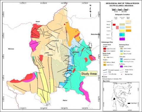
The geological structure observed in the study area is strongly influenced by tectonic processes and volcanism, as well as regional geological structures (Figure 1). These factors play a significant role in shaping the characteristics of the hot springs in the Wala area, Sangalla Selatan District. The study area, referred to herein as the Toraja South Sulawesi region, differs from the other geothermal systems of the volcanic arc Indonesia region and the northern Sulawesi areas. The region has a tectonic history as arc volcanic past records mainly in Neogene, but progressively into several phases of deformation potentially associated with continent collision necessity and importance [12, 13]. Therefore, it is necessary to provide geochemical characteristic data for an understanding of the geothermal system that is developing in this area.
The study aims to analyze the geothermal characteristics of the Makula hot springs through geochemical analysis. By conducting this analysis, the researchers seek to identify several characteristics that have contributed to the development of geothermal utilization in the research area. By studying the geochemical characteristics, researchers can gain a deeper understanding of the geothermal system and its suitability for various applications.
Figure 1. The study area in the geological map of the Toraja region [12, 13]
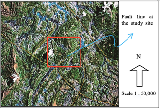
The research area exhibits a varied topography characterized by undulating hills, ranging in elevation from 775 to 1014 meters above sea level. These hills have been subject to erosion, specifically gulley erosion, which is the primary process at work in the area. Gulley erosion refers to the formation of channels or gullies caused by the removal of soil and sediment by concentrated water flow. The landscape unit of the study area can be identified through shape, parametric, and genetic approaches, along with the analysis of physical characteristics observed in the field. Based on these assessments, the landscape unit in the study area can be classified as a denudational wavy hill landscape unit (Figure 2).
This classification suggests that the dominant processes shaping the landscape in the study area are related to denudation. Denudation refers to the overall process of wearing away or stripping off the Earth's surface materials through various mechanisms, such as erosion, weathering, and mass wasting. In the context of the wavy hill landscape unit, denudation processes are responsible for the formation of the undulating hills observed in the area.
Figure 2. Denudational wavy hill landscape unit and the pattern of structural lineaments in satellite imagery map
The Makula hot spring is an intriguing geothermal phenomenon that emerges within granodiorite rock. Field observations suggest that this particular granodiorite rock has experienced deformation, likely due to tectonic forces acting on the Earth's crust over time. As a result, the rock appears to be fracturing, which plays a crucial role in the formation of the hot spring. Previous studies have provided confirmation of the brittleness of the granodiorite rock, as evidenced by its tendency to fracture under stress. The mechanical forces acting on the rock have also led to grain-size reduction of feldspars and recrystallization of quartz. These changes in mineral composition have important implications as they are directly related to the main heat source of the hot spring.
The primary heat source for the Makula hot spring is the recrystallized quartz found within the granodiorite rock. This indicates that the hot spring is geothermally driven, where heat generated from the Earth's interior is transferred to the surface through the fractured and permeable granodiorite rock.
The granodiorite rock, which hosts the hot spring and its heat source, belongs to the Palopo granitic rocks. Chemical analysis of the granitoid reveals specific characteristics, including high potassium (K), magnesium (Mg), and peraluminous compositions. The term "peraluminous" indicates an abundance of aluminum relative to other elements in the rock's chemical makeup. Moreover, the granitoid exhibits a calc-alkaline to alkali-calcic nature, suggesting a specific geological setting and tectonic environment in which it formed.
Geological dating of the Palopo granitic rocks has been performed using zircon dating techniques, which have confirmed the rocks to be of Pliocene age. This age estimation places the formation of the Palopo granitic rocks within a time range of approximately 5 to 6 million years ago.
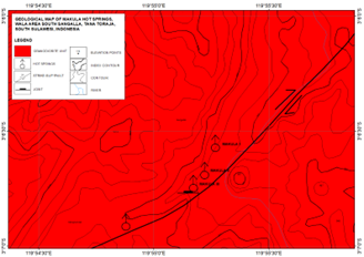
To gain a better understanding of the geological context, population data derived from several shear joints surrounding the hot spring emergence points have been analyzed. The results indicate a prevailing trend in the direction of the main stress, aligning closely with north-northeast to south-southwest orientation (N 344 ºE). This directional trend correlates with the general alignment of the Macula shear fault, which exhibits a relatively northeast-southwest orientation (Figures 2 and 3).
The presence of the Makula Shear Fault, with its specific orientation, suggests an active tectonic regime in the study area. This fault, along with associated fractures and faults, likely plays a crucial role in facilitating the movement of water from the surface to the underground reservoirs, contributing to the formation of the hot springs. The tectonic activity associated with this fault zone may also contribute to the availability of the natural heat required for the geothermal processes that heat the groundwater.
Furthermore, the influence of volcanism in the region cannot be overlooked. Volcanic activity can introduce additional sources of heat to the subsurface, further enhancing the geothermal system's potential for generating hot springs. The interaction between tectonic forces, volcanic activity, and the regional geological structures creates a complex and dynamic environment, providing favorable conditions for the formation and maintenance of hot springs in the study area.
The interplay between tectonic processes, volcanism, and regional geological structures shapes the geological framework of the study area and contributes to the occurrence of the observed hot springs. The alignment of shear joints with the main stress direction and the presence of the Makula Shear Fault suggests an active tectonic regime that influences the movement of water and the availability of geothermal heat.
Figure 3. Geological map of the study area
At three hot spring locations in the Wala Area of South Sulawesi, we conducted field observations of the Makula Hot Springs. Along with taking spring and lithology samples, we gathered a variety of data, such as the pH of the hot spring, spring temperatures, physical and chemical features, and air temperature. Two laboratories analysis was performed to analyze the ions contents of the hot springs such as the calcium, magnesium, chloride dan bicarbonate that was performed by titrimetry analysis and sulphate, potassium, sodium, and ammonia by Atomic Absorption Spectroscopy (AAS) analysis.
Analysis of chloride, bicarbonate, and sulfate was carried out to determine the hot springs' fluid type [14]. Typically, a ternary diagram of chloride, bicarbonate, and sulfate is used to determine the type of geothermal fluid. Each of the three ions is stand for different geothermal characteristics [15]. In this research, the Na-K geothermometer [16] is used to estimate the subsurface reservoir temperature.
$T^o C=\frac{1390}{[\log (N a / K)+1.750]}-273$ (1)
The Na/K geothermometer has undergone significant advancements in recent years. It originated from the observation that low Na/K ratios in geothermal waters were indicative of high temperatures at depth. Over time, researchers have worked on refining and calibrating the temperature dependence of this ratio, resulting in more precise measurements [16, 17]. In high-temperature geothermal systems, the variation of sodium and potassium in geothermal waters is primarily attributed to the ion exchange process between co-existing alkali feldspars. This exchange of ions is influenced by temperature, and as a result, the Na/K ratio can be used as an indicator of the subsurface temperature [18].
In addition to the Na/K geothermometer, the Na-K-Mg geo indicator is also utilized in geothermal research. This geo indicator takes into account the concentrations of sodium, potassium, and magnesium in geothermal waters. It serves multiple purposes, including determining reservoir temperature and identifying waters that have achieved equilibrium with the host lithologies [19].
In the study area, geothermal manifestations are observed in the form of Makula hot springs. The location of these hot springs revealed the presence of three distinct springs, referred to as Springs I, II, and III. These springs were investigated under sunny weather conditions, with the surrounding air temperatures recorded at approximately 27-28℃. A comprehensive overview of the physical and chemical characteristics exhibited by each of the hot springs provides in Table 1.
Table 1. Physical and chemical characteristics of hot springs
|
Parameters |
Hot Springs |
||
|
|
I |
II |
III |
|
Colour |
Transparent |
Transparent |
Transparent |
|
Scent |
Sulfur |
Sulfur |
Sulfur |
|
Flavor |
Acid |
Acid |
Acid |
|
Temperature |
41.5℃ |
41℃ |
37℃ |
|
pH |
8.5 |
8 |
8.5 |
Each hot spring exhibits a transparent appearance. The scent in all three springs is characterized by the presence of sulfur, contributing to the distinctive sulfuric odor commonly associated with geothermal features. Furthermore, the flavor of the water in all springs is described as acidic.
Regarding temperature, Hot Spring I register a temperature of 41.5℃, while Hot Spring II measures 41℃. Hot Spring III has a slightly lower temperature of 37℃. These variations in temperature indicate different levels of geothermal activity and heat output among the springs.
The pH values of the hot springs also differ slightly. Hot Springs I and III share a pH of 8.5, while Hot Springs II has a pH of 8. This information provides insight into the chemical composition of the water and its alkalinity or acidity.
These physical and chemical characteristics provide valuable insights into the distinct properties of each hot spring within the Makula area. Such information is crucial for understanding the geological and hydrological processes that contribute to the formation and unique characteristics of these hot springs.
4.1 Hot springs geochemistry
The geochemical analysis provides valuable information about the hot springs in the study area, including their classification as chloride-type springs and their association with deep geothermal fluids. The study focuses on three specific hot springs, as depicted in Figure 3. The analysis aims to determine the type of hot spring and estimate the subsurface temperature by employing a geothermometer. This estimation is derived from the chemical element composition of the hot spring samples. The findings of the geochemical analysis of the hot springs in the study area are presented in Table 2.
The analysis primarily examines the percentage value of ion content in the hot water samples, with a particular focus on bicarbonate anions (HCO3ˉ), chloride (Clˉ), and sulfate (SO42ˉ) concentrations. Based on these measurements, it is possible to determine that the three hot springs in the study area belong to the chloride type. This determination is supported by the relatively high concentration of chloride ions in the hot water compared to bicarbonate and sulfate concentrations, as well as the presence of a relatively alkaline pH range (pH 8-8.5) [20].
Table 2. Laboratory analysis of hot springs content
|
Parameters |
Unit |
Hot Springs |
||
|
I |
II |
III |
||
|
Sodium (Na) |
ppm |
82.42 |
83.47 |
84.4 |
|
Potassium (K) |
ppm |
1.5 |
1.44 |
1.22 |
|
Ammonia (NH₃) |
ppm |
0.002 |
0.003 |
0.004 |
|
Sulphate (SO₄) |
ppm |
22.54 |
31.71 |
34.65 |
|
Bicarbonate (HCO₃ˉ) |
ppm |
0.018 |
0.018 |
0.014 |
|
Calcium (Ca) |
ppm |
28.03 |
26.03 |
28.03 |
|
Magnesium (Mg) |
ppm |
2.002 |
4.004 |
2.002 |
|
Chloride (Clˉ) |
ppm |
117.15 |
108.28 |
113.6 |
The chloride fluid type is often associated with deep geothermal fluids found in high-temperature systems. Hot springs with a higher concentration of chloride ions are typically fed more directly from deep reservoirs. These areas with hot springs also help delineate permeable zones within the geothermal field, as they represent locations with the highest concentration of hot and large-flow springs [21].
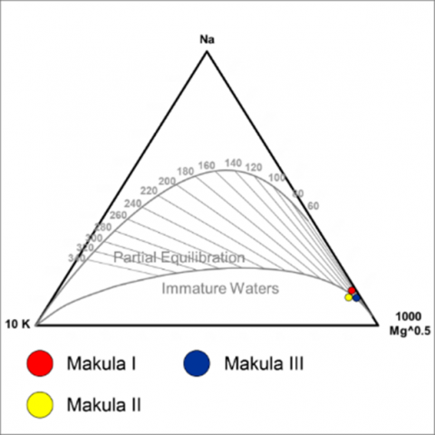
The results obtained from plotting the values of chemical element content in the Na - K - Mg triangle diagram (Figure 4) have provided valuable insights into the nature of the studied hot springs, particularly the Makula Hot Springs. The positioning of these hot springs within the partial equilibrium field on the diagram indicates that there has been significant rock interaction between the hot fluid and the surrounding geological formations before reaching the surface.
Figure 4. Ternary diagram for determining subsurface temperature of Makula
The process of partial equilibrium suggests that the hot water has undergone substantial chemical exchange with the rocks it encountered during its ascent. This interaction could have led to alterations in the chemical composition of the water and the incorporation of various elements from the surrounding rocks. As a result, the chemical signature of the hot springs reflects the influence of these rock-water interactions.
Furthermore, based on the characteristics revealed by the Na - K - Mg triangle diagram, the temperature of the hot water in these springs is classified as belonging to the category of low-temperature geothermal sources. This classification implies that the hot springs are not driven by extremely high geothermal gradients commonly associated with high-temperature sources. Instead, the temperature is relatively moderate but still warm enough to be considered geothermally influenced.
Additionally, the alkaline pH of the hot springs further supports the idea of partial equilibrium and rock interaction. The presence of alkaline pH suggests that the hot water has acquired certain dissolved minerals from the rocks, contributing to its alkalinity. Furthermore, the temperature of this hot water is classified as a low-temperature geothermal source. This means that the water is not as hot as high-temperature geothermal sources but still exhibits significant thermal energy. The relatively alkaline pH observed in these hot springs further supports their classification as low-temperature geothermal sources [22].
The comprehensive analysis of the Na - K - Mg triangle diagram and the corresponding findings on the temperature and pH characteristics of the Makula hot springs shed light on their geological origin and behavior. The relatively low-temperature and alkaline nature of these hot springs could make them suitable for certain applications, such as spa and therapeutic uses, as well as potentially serving as a viable source for certain geothermal energy utilization endeavors.
4.2 Geothermal system
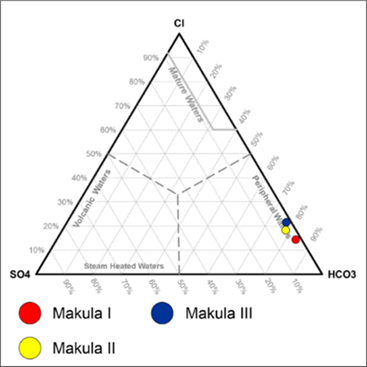
In the case of the study area, the relative content of Clˉ, HCO3ˉ, and SO42ˉ can provide valuable insights. Figure 5 illustrates that the hot water in the study area has a significantly higher concentration of Clˉ compared to HCO3ˉ and SO42ˉ. The high Clˉ content suggests that the hot water in Macula and its surroundings originates from volcanic activity [23]. Volcanic activity often involves the release of gases and minerals from magma chambers, which can then infiltrate the surrounding rock layers and interact with groundwater. This interaction leads to the enrichment of certain elements, such as Clˉ, in the hot water that emerges as hot springs. In this case, the dominant presence of Clˉ indicates a volcanic source, further supporting the connection to volcanic activity in the region.
Figure 5. Chloride fluid type of the Makula hot springs
By analyzing the distribution of hot springs and the temperature values obtained from dissolved elements geothermometry, have deduced valuable insights about the geothermal reservoirs in the study area, specifically the ones supplying Makula I, Makula II, and Makula III hot waters. The calculated temperatures for these reservoirs are approximately 124.69℃, 122.65℃, and 114.75℃, respectively. Interestingly, there is a notable trend in the reservoir temperatures concerning their spatial distribution. As one moves further north in the study area, the reservoir temperature is presumed to be higher, suggesting that the geothermal activity is more intense in that direction. Conversely, as the study area extends southwards, the hot water reservoir temperatures tend to be lower.
The three hot springs, Makula I, Makula II, and Makula III, are identified as chloride-type springs, indicating that they directly output (up-flow) reservoir water without significant alteration or mixing with other sources. This characteristic is noteworthy, as it helps establish a clear connection between these hot springs and the specific geothermal reservoirs from which they originate.
The application of Na-K geothermometer calculations and the analysis of dissolved elements have provided valuable data to characterize the temperature distribution and nature of the geothermal reservoirs in the study area, shedding light on the behavior of these hot springs and the geothermal system as a whole.
The hot spring reservoir falls under the category of low enthalpy, characterized by temperatures below 125℃, making it classified as a low-temperature geothermal system [24]. The existence and emergence of hot springs depend on the presence of a geothermal magma chamber as a heat source beneath the Earth's surface. Without such a magma chamber, hot springs cannot form or become visible on the surface.
The location and depth of the magma chamber are crucial factors determining the presence of hot springs. In the study area, the size of the magma chamber is closely linked to volcanism, which influences the geological characteristics of the region. As magma ascends towards the surface, it undergoes differentiation and chemical changes based on its depth, resulting in different compositions of elements in the hot water of each hot spring within the study area. The variation in chemical arrangements gives rise to differences in the percentage of hot water elements observed in different hot springs [25, 26].
It's important to note that there was no steam present in the study area's hot springs due to the lack of contact with the air. Instead, the hot water emerged to the Earth's surface through cracks or fractures in the rocks caused by the geological structure of the area. This indicates that the path of the hot water from the underground reservoir to the surface is facilitated by the presence of these structural features, allowing the hot springs to manifest in specific locations within the study area [27].
In the geothermometer analysis, taking into account the surface temperature of hot water in the study area, which is measured at 41.5℃. By comparing it with the subsurface temperature, which is approximately 124.69℃, they can calculate the geothermal gradient or depth of the magma chamber. Based on the non-volcanic magmatic pathway assumption, they find that for every 100 meters of descent or depth, the temperature increases by about 2.5℃ to 3℃. Using this information, they estimate that the depth of the magma chamber in the study area is approximately 3.71 kilometers from the surface. This calculation is based on the temperature difference between the surface and subsurface measurements [28].
Furthermore, conducted additional analyses at different temperature points. For instance, when the surface temperature of hot water is measured at 41℃ and the subsurface temperature at 122.65℃, the geothermal gradient is estimated to be around 3.66 kilometers from the surface. Similarly, at a surface temperature of 37℃ and a subsurface temperature of 114.75℃, the geothermal gradient is calculated to be approximately 3.53 kilometers [29].
Even though the geothermal system produces energy resources that are always renewable, it does not mean that they will last indefinitely, thus there must be an effort to determine the activity lifetime of a geothermal source. Indirect age determination of an active geothermal system. Determining the age in this way is carried out through a comparative study of the relative age of the rocks in the study area with the results of the hydrothermal process on the age of the reservoir rock so that the age of this geothermal activity can be known indirectly. This age determination is carried out through studies on the role of structural openings in hydrothermal processes, closing of structural openings, and reshaping of openings/fractures. As well as the age of the overburden and the age of the structure. The Pliocene of Palopo granitic rock’s regional physical characteristics is compared to the lithology found in the study area to estimate the age of the Makula hot springs geothermal system [30].
In the research area, the non-permeable or covered rock that acts as an impermeable cap is specifically identified as granodiorite rock (Figure 6). This type of rock serves a critical role in the geothermal processes occurring beneath the Earth's surface. Due to various structural processes at work in the research area, geothermal energy is able to rise to the surface, manifesting itself as geothermal features, specifically in the form of hot springs.
Figure 6. The conceptual model of the geothermal in the study area
The granodiorite rock acts as an effective barrier, preventing the geothermally heated water from escaping prematurely and ensuring that the necessary pressure and heat build-up can occur. Its impermeable nature restricts the upward movement of water, allowing it to accumulate and become heated in the underground reservoir. As a result, the geothermally heated water, enriched with dissolved minerals and heat energy, gradually rises through fractures and faults in the surrounding rock layers.
These structural processes, which could include faulting, folding, or other tectonic activities, create pathways for the heated water to ascend toward the surface. As the water travels along these fractures and faults, it gradually gains temperature and reaches a point where it emerges as hot springs.
The presence of the granodiorite cover rock, coupled with the interplay of geological forces in the research area, contributes to the formation and manifestation of geothermal energy in the form of hot springs. The emergence of these hot springs not only provides unique geological and hydrothermal features but also serves as a valuable indicator of the underlying geothermal energy potential in the region.
4.3 Geothermal utilization in the research area
To optimize geothermal resources, it is beneficial to explore the potential of geothermal energy for direct use, in addition to its utilization as an alternative source of electricity. The identification of a hot water source involves examining its physical characteristics, conducting chemical analysis to determine factors like pH value, and measuring the temperature of the hot water. This comprehensive evaluation allows for a better understanding of the resource and facilitates its utilization in various applications, including the development of hot springs as tourist attractions.
By analyzing the physical characteristics of a hot water source, such as its flow rate, pressure, and geologic features, experts can assess the potential of the resource for different uses. Chemical analysis, including pH measurements and assessment of mineral content, provides insights into the water's suitability for specific purposes. For instance, if the water contains high levels of certain minerals, it may be suitable for therapeutic or medicinal uses, which can enhance the appeal of hot springs for health and wellness tourism.
Temperature measurements play a crucial role in determining the energy potential and heat output of the hot water source. Higher temperatures indicate a greater capacity for energy production or direct utilization, such as space heating, industrial processes, or agricultural applications. Lower temperature sources may still be suitable for recreational uses, like hot tubs or bathing facilities, and can contribute to the development of leisure-focused hot spring destinations.
In the context of geothermal energy development, direct-use applications have gained attention as they provide a more localized and efficient means of utilizing the resource. By harnessing geothermal heat directly from the source, without the need for electricity generation and transmission, the overall energy efficiency can be improved. This approach aligns with sustainability goals and reduces greenhouse gas emissions associated with conventional energy sources.
Furthermore, the development of geothermal resources for direct use, such as hot springs, can have significant economic benefits. These sites often attract tourists, contributing to local economies through increased tourism revenue, job creation, and business opportunities. Hot springs, in particular, offer recreational and relaxation experiences, promoting wellness tourism and providing a unique natural attraction for visitors.
Optimizing geothermal resources involves not only exploring their potential for electricity generation but also assessing their direct-use applications. By considering physical characteristics, conducting chemical analysis, and evaluating temperature profiles, experts can identify hot water sources suitable for various purposes. The development of hot springs as tourist attractions is one such application, offering economic and recreational benefits while leveraging the natural geothermal resource.
The geothermal characteristic study of the Makula hot springs has several unique properties including a high content of chloride ions when compared to the bicarbonates and sulphate this chloride type is a geothermal fluid that is fed directly from the deep reservoir in the research area. The estimated temperatures are quite similar, defining that these hot springs are fed from the same reservoir with a range from 114℃ to 124℃, the low enthalpy geothermal area. The Makula III hot springs have the lowest temperature which can be interpreted that Makula III is the area that has the most diluted than the other hot springs which are contaminated with groundwater or meteoric water on the surface.
The basis of geochemical interpretation led to the creation of the geothermal system model in this study which includes geothermal system components a represent the main heat source for non-volcanic hot springs govern by meteoric water that has possibility generated in deep-seated. Future research in geology and geophysics is necessary to analyze and create detailed geothermal conceptual models that can aid in future geothermal utilization.
[1] Pambudi, N.A. (2018). Geothermal power generation in Indonesia, a country within the ring of fire: Current status, future development and policy. Renewable and Sustainable Energy Reviews, 81(2): 2893-2901. https://doi.org/10.1016/j.rser.2017.06.096
[2] Pirajno, F. (2020). Subaerial hot springs and near-surface hydrothermal mineral systems past and present, and possible extraterrestrial analogues. Geoscience Frontiers, 11(5): 1549-1569. https://doi.org/10.1016/j.gsf.2020.04.001
[3] Erfurt, P. (2012). An assessment of the role of natural hot and mineral springs in health, wellness and recreational tourism. Unpublished doctoral dissertation, School of Business, James Cook University, Cairns, Queensland, Australia. https://www.researchgate.net/publication/344755451.
[4] Sparks, R.S.J., Annen, C., Blundy, J.D., Cashman, K.V., Rust, A.C., Jackson, M.D. (2019). Formation and dynamics of magma reservoirs. Philosophical Transactions of The Royal Society A, 377(2139): 20180019. http://dx.doi.org/10.1098/rsta.2018.0019
[5] González, J., Zambra, C.E., González, L., Clausen, B., Vasco, D.A. (2022). Simulation of cooling in a magma chamber: Implications for geothermal fields of southern Peru. Geothermics, 105: 102515. https://doi.org/10.1016/j.geothermics.2022.102515
[6] Delmelle, P., Henley, R.W., Bernard, A. (2015). Volcano-related lakes. In the Encyclopedia of Volcanoes, 2nd ed. Academic Press, London.
[7] Fischer, T.P., Chiodini, G. (2015). Volcanic, magmatic, and hydrothermal gases. In the Encyclopedia of Volcanoes, 2nd ed. Academic Press, London.
[8] Jaya, A., Nishikawa, O., Sufriadin, Jumadil, S. (2021). Fluid migration along faults and gypsum vein formation during basin inversion: An example in the East Walanae fault zone of the Sengkang Basin, South Sulawesi, Indonesia. Marine and Petroleum Geology, 133: 105308. https://doi.org/10.1016/j.marpetgeo.2021.105308
[9] Nilandaroe, N., Mogg, W., Barraclough, R. (2002). Characteristics of the fractured carbonate reservoir of the Oseil field, Seram Island, Indonesia. In 28th Annual Convention Proceedings, 1: 439-456. https://doi.org/10.29118/ipa.399.439
[10] Hategekimana, F., Mugerwa, T., Nsengiyumva, C., Byiringiro, F.V., Rwatangabo, D.E.R. (2022). Geochemical characterization of Nyamyumba hot springs, northwest Rwanda. Applied Chem, 2: 247-258. https://doi.org/10.3390/appliedchem2040017
[11] Porras-Toribio, I., Pi-Puig, T., Villanueva-Estrada, R.E., Rubio-Ramos, M.A., Solé, J. (2022). Mineralogy, geochemistry, and stable isotopes (C, O, S) of hot spring waters and associated travertines near Tamiahua Lagoon, Veracruz, Gulf of Mexico (Mexico). Minerals, 12: 822. https://doi.org/10.3390/min12070822
[12] White, L.T., Hall, R., Armstrong, R.A., Barber, A.J., Fadel, M.B., Baxter, A., Wakita, K., Manning, C., Soesilo, J. (2017). The geological history of the Latimojong region of western Sulawesi, Indonesia. Journal of Asian Earth Sciences, 138: 72-91. https://doi.org/10.1016/j.jseaes.2017.02.005
[13] Djuri, Sudjatmiko, Bachri, S., Sukido. (1998). Geological Map of the Majene and Western Part of the Palopo Sheets, Sulawesi (1:250,000). Geological Research and Development Centre, Bandung, Indonesia.
[14] Ramadhan, Y., Channel, K., Herdianita, N.R. (2013). Hotwater geochemistry for interpreting the condition of geothermal reservoir, dieng plateau case, Banjarnegara-Wonosobo Regency, Central Java. Indonesian Journal of Geology, 8(2): 89-96. https://doi.org/10.17014/ijog.8.2.89-96
[15] Nicholson, K. (1993). Geothermal Fluids Chemistry and Exploration Technique. Springer-Verlag, Inc.: Berlin Heidelberg New York.
[16] Giggenbach, W.F. (1991). Chemical techniques in geothermal exploration. Application of Geochemistry in Geothermal Reservoir Development, 119-144.
[17] Can, I. (2002). A new improved Na/K geothermometer by artificial neural networks. Geothermics, 31(6): 751-760. https://doi.org/10.1016/S0375-6505(02)00044-5
[18] Ellis, J.A., Mahon, J.A.W. (1997). Chemistry and Geothermal System. Academic Press, London.
[19] Iswahyudi, S., Siswandi, Attabik, L.W., Saifrudin, N.A. (2020). Reservoir temperature calculation of immature geothermal water from hot spring around the Slamet volcano. In IOP Conference Series: Earth and Environmental Science, 417: 012006. https://doi.org/10.1088/1755-1315/417/1/012006
[20] Li, X., Azimzadeh, B., Martinez, C.E., McBride, M.B. (2021). Pb mineral precipitation in solutions of sulfate, carbonate and phosphate: measured and modeled pb solubility and Pb²⁺ activity. Minerals, 11: 620. https://doi.org/10.3390/min11060620
[21] Skoog, D.A., Holler, F.J., Crouch, S.R. (2017). Principles of Instrumental Analysis. Cengage Learning.
[22] Shah, M., Sircar, A., Shah, V., Dholakia V, (2021). Geochemical and Geothermometry study on hot-water springs for understanding prospectivity of low enthalpy reservoirs of Dholera Geothermal field, Gujarat, India, Solid Earth Sciences, 6(3): 297-312. https://doi.org/10.1016/j.sesci.2021.04.004
[23] Taran, Y., Kalacheva, E. (2020). Acid sulfate-chloride volcanic waters; Formation and potential for monitoring of volcanic activity. Journal of Volcanology and Geothermal Research, 405: 107036. https://doi.org/10.1016/j.jvolgeores.2020.107036
[24] Dávalos-Elizondo, E., Atekwana, E.A., Tsokonombwe, G.D., Laó-Dávila, A. (2021). Medium to low enthalpy geothermal reservoirs estimated from geothermometry and mixing models of hot springs along the Malawi Rift Zone. Geothermics, 89: 101963. https://doi.org/10.1016/j.geothermics.101963
[25] Pasquale, V., Verdoya, M., Chiozzi, P. (2015). Measurements of rock thermal conductivity with a Transient Divided Bar. Geothermics, 53: 183-189. https://doi.org/10.1016/j.geothermics.2014.05.008
[26] Rasmussen, D.J., Plank, T.A., Roman, D.C, Zimmer, M.M. (2022). Magmatic water content controls the pre-eruptive depth of arc magmas. Science, 275(6585): 1169-1172. https://doi.org/10.1126/science.abm5174
[27] Manyoe, I.N., Suriamihardja, D.A., Irfan, U.R., Eraku, S.S., Napu, S.S.S., Tolodo, D.D. (2020), Geology and 2D modeling of magnetic data to evaluate surface and subsurface setting in Bongongoayu geothermal area, Gorontalo. IOP Conference Series: Earth and Environmental Science, 589: 012002. https://doi.org/10.1088/1755-1315/589/1/012002
[28] Ichiki, M., Kaida, T., Nakayama, T., Miura, S., Yamamoto, M., Morita, Y., Uyeshima, M. (2021). Magma reservoir beneath Azumayama Volcano, NE Japan, as inferred from a three-dimensional electrical resistivity model explored by means of magnetotelluric method. Earth Planets Space, 73: 150. https://doi.org/10.1186/s40623-021-01451-y
[29] Dalampakis, P., Papachristou, M., Neofotistos, P. (2022). Geothermal resources assessment using temperature–depth relationships in the fault-controlled hydrothermal system of Aristino-Traianoupolis area, Northern Greece. Geotherm Energy, 10: 22. https://doi.org/10.1186/s40517-022-00232-4
[30] Liu, J., Zhang, J., Hsia, J., Xian, W.W., Yin, C., Djoko F.X., Cheng, C., Zhao, C., Liu, X., Chen, Y., Wang, X. (2020). Late Miocene to Pliocene crustal extension and lithospheric delamination revealed from the ~5 Ma Palopo granodioritic intrusion in Western Sulawesi, Indonesia. Journal of Asian Earth Sciences, 201: 104506. https://doi.org/10.1016/j.jseaes.2020.104506