Sara Mohamed Omar Ali*![]() | Ehab Mahmoud Okba
| Ehab Mahmoud Okba![]() | Neven Sabri
| Neven Sabri![]()
© 2023 IIETA. This article is published by IIETA and is licensed under the CC BY 4.0 license (http://creativecommons.org/licenses/by/4.0/).
OPEN ACCESS
This study examines the use of landscape design to replace slums in residential areas. The research is based on a descriptive and analytical approach, drawing information from previous studies that have addressed landscape design to achieve sustainability in residential areas. The study aims to develop a comprehensive assessment of the use of landscape elements in an environmentally sustainable manner, focusing on site coordination, water, energy, soil, vegetation, maintenance operations, and materials. The research also considers the impact of landscape design on human well-being. The study was applied to the Rawdat Al-Sayeda Zeinab area in Cairo, and the results were compared with planned landscape designs to identify differences and necessary modifications. The study provides guidelines for using landscape design to achieve sustainability in residential areas and sets a direction for future research.
landscape, environmental sustainability, residential areas, slums, replacement, Egypt
Many years ago, the world's interest became a wave to external open spaces. This interest led to the emergence of the term "landscape," it aimed to achieve beauty in open spaces and interest in the impact of nature and man on the place, so it studies the relationship between nature and the built environment.
The design of landscaping is one of the designs that have attracted the attention of architects at the present time, as landscaping is one of the important and essential matters in preserving the environment and the sustainability system in all its directions, and since environmental problems have emerged strongly in recent times and because of the lack of interest in landscaping, this has led to focus developing a design idea that leads to environmental balance and preserving the architectural and urban character, especially random residential areas, while working to protect the elements of the natural environment and their consistency, Therefore, the importance of the research lies in clarifying the standards and requirements necessary to achieve environmental sustainability by landscape in the random residential areas after their replacement. after replacing it, and landscape is a pivotal and necessary part of the methods of achieving sustainability in order to improve and develop the environment and work to improve the livelihood of individuals through it, especially in Random areas that do not possess any of these values, The research aims to reach a way to integrate the principles and criteria of sustainability with the elements of the site and to reach a comprehensive evaluation system to achieve environmental sustainability through landscape in the random residential areas after the replacement, and through sustainability, its foundations, standards and methods of application in landscape of residential areas, especially slums after their settlement, to achieve psychological comfort and social cohesion in order to achieve a positive impact on the behavior of the residents of these residential areas and until the resulting negative effects are eliminated by the replacement of slums. The research was viewed from this direction due to the lack of previous studies to research the sustainable landscape and the extent of its importance and impact on the residential area in general and its residents in particular. They also dealt with landscape in enriching aesthetic and functional values and its impact on planning and land use distribution. Environmental sustainability was not addressed and how to achieve it through landscape, especially in slums after replacement, in order to clarify the extent of the impact of this verification on the population present in these areas and the importance of addressing these areas properly. Not just my design.
Attention to sustainability has increased during the past years. It has become a necessity that cannot be ignored due to the deterioration that afflicted the environment in general, especially the urban environment, and its impact appeared on environmental resources and on humans, which prompted the whole world to pay attention to the environment and how to avoid damage to it, whether in the short or long term.
2.1 Concepts of sustainability
According to each perspective that looks at sustainability, sustainability has many concepts and definitions. Many sectors can apply sustainability to their approaches and goals. The trend towards sustainability is an inevitable necessity due to the large consumption of natural materials daily and increasingly, as the world consumes a lot of diverse energy in devices and electrical equipment.
Humanity sought to implement sustainability, despite the lack of a clear definition, as it realized the importance of preserving resources, especially land and nutrients.
Sustainability has been divided into several types that its different dimensions can identify, and they are:
Environmental Sustainability: Environmental sustainability aims to preserve the planet's environment and maintain the quality of life [1].
Economic Sustainability: It aims to solve financial problems by distributing fair and appropriate wealth to different societies that allow for increased production [2].
Social Sustainability: It seeks to achieve social equality and work to expand quality education.
2.2 Dimensions and objectives of sustainability
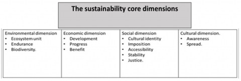
Sustainability faces many problems today due to the consumption of energy in large quantities, exposing us to enormous risks in the world. For this reason, sustainability aims mainly to create a global conscience. And the importance of educating people that we are all on one planet and we must be interdependent and bear in mind that future generations have a right over us. Figure 1 is an illustration of these dimensions, which are represented in several points, namely:
- Rationalizing the consumption of local resources.
- Enhancing environmental aspects.
- Creating a healthy environment.
- Local community value.
- Promote inclusive growth to improve livelihoods and promote sharing economies.
- Diversification increases productivity, creates job opportunities and adds nutritional value to food systems.
The most important way to apply the environmental dimensions is to spread environmental awareness and the extent of the impact of this awareness on preserving the beauty of nature, water, soil, and biodiversity, to provide natural resources for humans because these resources meet the human need for living and also ensure the growth of the population [3].
Figure 1. The sustainability core dimensions
Source: The researcher’s work
2.3 Challenges and obstacles to achieving sustainability
Today, the world faces many enormous challenges due to technological development, great industrial progress, and increasing population growth. These challenges have many types, the most important of which are:
-Environmental challenges: Use of natural resources, pollution, limited water resources and land desertification, climate change, loss of biodiversity.
- Social challenges: The lack of a culture of voluntary work, material need, unemployment.
-Economic challenges: The economic factor clearly impacts achieving sustainability regarding the availability of financial capabilities and the best way to use them according to the country’s economic situation [4].
2.4 Levels and indicators for measuring sustainability
Sustainability has four levels; in these levels, several social, environmental, and cultural dimensions affect its formation, as the urban level has standards for countries, cities, neighborhoods, and residential communities through their natural and physical environment and infrastructure [5]. The architectural level focuses on the building from the inside in terms of its internal spaces and human psychology inside the building and its requirements. The social level is linked to the environment from the perspective of the comfort of individuals in it. The economic level includes raising awareness of interest in professional and professional development and preparing training and human development plans for community members [6].
The interest in measuring sustainability has increased due to the need to evaluate many of the sustainability standards it works to achieve, whether at the environmental, social, or economic level. To build appropriate indicators to achieve sustainability, he uses tests and experiments for indicators and evaluation tools to raise the value of measuring indicators. Many systems and approaches have been developed to determine sustainability indicators, such as Human Development Index (HDI), Environmental Sustainability Index (ESI), Performance Indicator Environmental Pioneering Index (EPI), Real Progress Index (GPI), and these indicators on environmental sustainability are reflected in Table 1.
Table 1. Environmental sustainability indicators
|
Environmental sustainability indicators |
Explanation |
|
Water |
Preserving and protecting water resources, whether groundwater or fresh water and their ecosystems. |
|
Health |
Taking care of the air quality because of its high impact on public health. |
|
Energy |
Reducing the consumption of non-renewable materials and trying to consume renewable materials to reduce the negative effects of energy on the environment. |
|
Education |
Attention to education ensures the entry of the environment into public information and educational programs because it helps the interest of all segments of society in the environment. |
|
Food |
Sustainable use is ensured by developing and preserving land, forests, water, wildlife, fish, and water resources. |
|
Service |
Provide suitable and ideal functions for the lands and their use to preserve forests and lands so that they are sustainable by using modern farming methods. |
|
Income |
Taking care of the natural resources necessary to ensure economic growth is essential to sustainability. |
Source: The researcher's work
The emergence of the landscape was a result of the urban development that took place over the ages and the existence of the community's need for external spaces in which various activities are carried out, designed to meet the needs of users not to lose sight of visual beauty [7].
3.1 Landscape concept
Landscaping is the specialty of environmental architecture because it aims to create and coordinate external spaces of all kinds and to try to integrate the natural environment and the urban environment and their interdependence to serve man to achieve easy, smooth, and balanced interaction. Newton defined site landscaping as "the art or science of landscaping and its elements for a safe, healthy, and comfortable life for human beings [8].
Landscape is a process based on scientific and artistic principles and basics in coordinating and planning external spaces and linking the various elements of the environment in a coherent balance and harmony that has an aesthetic appearance.
3.2 Landscape objectives
The landscape has a fundamental role in urban planning, as it determines a percentage of the urban environment for it, given that it is not only a means of entertainment for users and mitigation of overpopulation and traffic but also considers the climate. The objectives of the landscape are divided according to many aspects of delusion:
- Environmental objectives: providing an appropriate environmental atmosphere, solving part of the problem of air, visual or sound pollution by coordinating the site according to engineering principles and standards [9], exploiting natural resources, planting trees in streets or sites in general and at distances suitable for their sizes, using trees for protection from dust, and using them as windbreakers and environmental pollution.
- Aesthetic goals: beautifying cities and residential areas, coordinating streets and squares, defining the distinctive mental image of the place, and the green color represented in plants and trees is one of the most important foundations of visual unity.
- Social goals: Provide a suitable place for the population to relax, calm, and recuperate, provide places for children to play, practice sports, and socialize between residents and each other.
- Functional goals: separating buildings to provide privacy for buildings and residential units in terms of function, creating a relationship between man and his urban, working to reduce the damages of harsh climate, whether by providing places with shade or reducing the temperature or reducing the percentage of dust and wind.
3.3 Patterns and levels of landscape
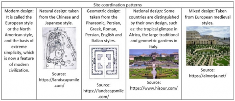
The design patterns differ and vary in landscape, and Figure 2 illustrates these patterns. The geometric pattern means the design with straight geometric lines, considering the symmetry in the distribution of trees and plants. They are of regular configurations, dimensions, and regular distances, whether in rows or repeated circles with equal distances. The natural pattern in which the landscape is designed according to nature is its uneven and tortuous nature. The basic idea of this design is to enjoy the beauty of nature and what it contains views and benefits from the site's topography. The mixed style is a mixed design between geometric and natural design with the adoption of opposite geometric shapes and the modern style. It is considered one of the methods of mixed design and is designed to suit the various available functions and resources. It is often characterized by simplicity, wide open spaces in many cases, and the national style. Some countries are distinguished by their design, such as the tropical glimpse in Africa and Italy's large and geometric traditional gardens.
Figure 2. Site design pattern
Source: The researcher's work
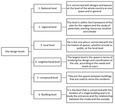
Landscape levels varied according to the design and planning and their levels. Figure 3 shows the gradation of these levels, including the national level, concerned with designs and planning at the state level as a whole and in general, and the regional level. The local level, which is concerned with the formation of spaces, whether private or public, at the local level neighborhood level, and is considered the largest level in terms of studying design and landscape; depending on the needs and levels of users, the level of residential groups, which are the spaces between buildings that are used to serve the population, the building level, which is The level that pertains to the location of a single building and is to study the entrances and the relationship between the inside and the outside.
Figure 3. Site design levels
Source: the researcher's work
3.4 Types of spaces and different elements in landscape
The spaces in the city are generally divided into two types: A natural void, which is formed due to natural phenomena, and the designer must deal with these phenomena carefully, naturally, and realistically, applying design expertise to the natural [10], and a manufactured space is defined by manufactured elements and divided into two spaces:
- External space: Movement paths, the spaces through which we see all the buildings and landscapes around us. The paths are divided into several types: streets, squares, pedestrian paths, and green areas.
- Squares: They are public spaces that represent life and movement in the street, such as buildings, spacious squares, and public parks [11].
Attention must be paid to landscape elements because of their strong influence on the design of sites and adding a sense of belonging. The elements have several types, and they are divided into:
- Natural elements: It consists of plant elements, which are divided into trees, palms, shrubs, climbers, outriggers, herbaceous plants, roses, flowers, succulent plants, aquatic and semi-aquatic plants, mobile garden plants, and water elements, which are divided into water basins, fountains, still water and turbulent water.
- Industrial elements: Seats, seating areas, shading elements, lighting elements, signs, guide signs, sculptural elements, artwork, flower beds, trash cans, and service elements.
- Solid elements: It consists of floors, stairs, and ramps.
3.5 Factors affecting the design of landscape elements
Many factors affect the design and selection of appropriate elements. Still, these factors are divided into:
- Natural factors:
Natural factors related to the site: Each site is characterized by some characteristics that give it a different character and characteristics from the rest of the sites, such as elevations in the site, existing natural resources, or natural afforestation elements in the place, but there are some natural obstacles such as temperature, sunlight, wind quantity and direction, Humidity, topography, soil type, location and its relationship to its surroundings [12].
- Urban factors:
1- Abnormal factors related to humans: There are many factors in which man is the cause or that it affects the place, and we can divide them into three points: the nature of the activity of the site, security and safety factors, and social and cultural factors.
2- Abnormal factors related to the site: It is divided into several factors, namely: the style of the surrounding buildings, customs, and traditions, the intellectual, civilized, and cultural level, the experience of the designer, the owner, and his requirements, historical factors, technological factors, functional factors, and economic factors.
Residential areas are the main part of forming residential and social communities. They are considered the main pillar for the psychological stability of the population and healthy social life. The important thing that appeared in the residential areas was the spread of class buildings in a close manner to each other, which led to it being the dominant building in the residential areas without taking into account the social requirements in the design of the buildings and the spaces surrounding it, so the social relations became almost missing.
4.1 The concept of residential areas and the historical perspective of their development
Residential areas are clusters of housing that must be sheltered and meet basic needs and are considered an integrated environment in which urbanization and development can be reached. Hence, they are one of the main factors in the growth of society. Residential areas include housing, roads, services, transportation, and facilities. The residential areas in the city represent about 60% of the city's total area. The structure of residential areas is considered to be neighborhoods, roads, streets, green areas, and places for institutional, administrative, and cultural services.
The history of the concept of residential areas can be divided into several basic periods, as the patterns and style of designing residential areas over the ages have changed dramatically depending on the change of many elements such as the human being himself, culture, and technological development.
4.2 Objectives of residential planning areas
There are many objectives for establishing residential areas, including the ability to renovate existing residential areas, preserve ancient buildings, and the possibility of future expansion depending on the expected population increase. Develop theories and foundations according to modern systems compatible with each area. Identify problems in existing residential areas and develop appropriate solutions for them, and develop it [13].
4.3 Design standards for residential areas
There are many basic criteria for designing and planning residential areas. These criteria are divided into several points, namely:
- Environmental standards: These are very important factors in the design, and all aspects of environmental considerations must be taken into account to obtain thermal comfort and work to reduce all electrical and mechanical treatments [14], distinctive places in the sites that affect the formation to produce an appropriate surrounding environment, taking into account trends. The origin, wind direction, and topography of the site, trees, which are among the most important elements present in the site, which affect aesthetically and create voids in the residential areas around the buildings, landscapes, which introduce comfort to users and help them in directing to functional spaces, and Table 2 shows the difference in standards between levels, whether on the public site or building.
- Formative standards: Plastic standards appear in the relationship between the shape of the open spaces and the shape of the building itself. We can divide the shape and function of the open spaces surrounding the building into linear spaces and combined spaces.
- Social standards: Many considerations must be taken into account to create a space that creates social connections and safe spaces and allows a lot of activities. Among the most important features of these spaces are forming friendships and social relations between residents, providing privacy and possession, and creating adequate security in the area.
Table 2. Standards within the levels of residential areas
|
General site level |
Building block and facades level |
|
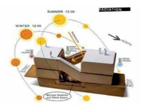
This is done by adjusting the orientation of buildings and spaces in residential areas, where air movement is allowed to permeate the site, according to the identification of the characteristics of the wind and its movement in this region. It varies from region to region according to the areas of low and high pressure, the intensity of the winds, the relationship of the site with the surrounding sites, and the site's topography and climatic map. |
When designing the location of the building in residential areas, it is taken into account to direct the building according to the angles of the sun's rays to determine the amount of shade on the façade, as shown in Figure 4, and to know the division of spaces inside the building and to protect the openings of the building from solar radiation and reduce excess heat on it. Figure 4. The angles of incidence of the sun on buildings Source: https://www.pinterest.com/pin/27866091419592543/ |
Source: the researcher's work
4.4 Planning and design considerations for residential areas
-Determine the relationship between the residential areas and the ways of connecting them to the different areas for services, whether the city center or work sites.
-Determine the population density that the residential area can bear and determine the number of housing units and the type of housing.
-Establishing a residential environment that protects the area from sound and environmental disturbances.
-Design according to determining the appropriate amount of sun and air and their access to residential units, open spaces, and green areas.
-Putting the infrastructure into account in the design.
-Determine the heights of the building according to the site's characteristics, the need for expansion in the future, the housing density, and the economic level.
-Providing various services according to the level of the residential area and the population density according to present and future expectations.
-Considering privacy in design.
-Determine the internal relations in the residential areas.
-Taking into account the need to supply the region and future expansion.
4.5 The impact of applying aspects of sustainability in residential areas on its residents
The role of environmental psychologists was to know how the surrounding environmental conditions shape human behavior, as it was considered that the residential area is the place that does not include the population carrying out activities only but that these areas include socially integrated structures aimed at regulating population activity, and also includes normative systems that define the relationship between individuals and social policies All of this seeks to achieve sustainable social, economic and environmental goals and values [15]. We deduce the characteristics of the population resulting from their impact on the residential area after applying the various aspects of sustainability in it, which are:
-Increasing the interest of individuals in the healthy aspect of their lives.
A sense of stability in residential areas and belonging to the dwelling and residential area.
-The tendency to increase social interaction between the inhabitant and the residential area.
Low crime and delinquency rates.
-Residents sought to develop themselves and find suitable job opportunities for them.
-The development of societies and the achievement of prosperity and progress will positively impact the state and its progress.
4.6 The different dimensions of LANDSCAPE that contribute to achieving sustainability in residential areas
Site landscaping is used to achieve environmental balance from the salvation of its natural elements through bodies of water, soil, roads, and footpaths. It can also detail how to achieve a sustainable landscape dimension in residential areas by improving the climatic environment, health dimension, noise protection, soil protection, and rationalization. Natural Resources.
There are several aspects when achieved in landscaping the site in residential areas that guarantee its sustainability. They are the rationalization of water through landscaping the site by planning the landscaping of the site and preparing the soil and selecting the type of plants and natural fertilization of the soil and implementing the traditional guidelines in landscaping the site, and rationalizing energy through landscaping the site using energy conservation in summer through shading and energy conservation in winter through wind protection.
The phenomenon of slums has spread in many cities worldwide and has increased for several reasons. Still, the reason that led to its significant increase is the internal migration from rural areas to cities and also the lack of laws, legislation, and plans for the division of lands, which led to a rise in prices, which was difficult for low and limited income groups provide them with adequate housing that they can pay for, which prompted them to migrate and live on the outskirts of the city and seize the vacant lands.
5.1 The concept of slums and the reasons for their emergence
They are residential communities that lack urban planning and do not adhere to legislation and building codes. These communities may be informal areas, so they either encroach on agricultural lands or lands belonging to the state. These areas do not include the facilities and infrastructure the government provides, such as water, electricity, and sanitation.
The slums arose for several reasons, including people's need for housing and shelter and the absence of the state's role. We can summarize the reasons in several points or motives, whether coercive, economic, or investment, and also because of the population increase as a result of migration from the countryside to the cities, the trend has become to establish illegal housing in the outskirts The city and the establishment of many private places. Some factor that led to the slums is the lack of facilitation measures to help obtain legal housing. The expatriates from the countryside are unwilling to deal with the official authorities as a result of the high prices of housing units in urban areas, so the trend has become to housing alternatives with less costly randomness, the inability of the government and authorities to track the rural attack to the big cities.
5.2 Slums problems
Problems arose due to the lack of planning and facilities in slums that provide an easy life and the lack of awareness of the population and residents in slums [16]. Problems in slums are divided into:
-Social and economic problems in residential areas: the spread of crime and its high rate, the increase in the rate of family disintegration, the increase in the rate of illiteracy, the increase in the rate of unemployment,
-Environmental problems in residential areas: the lack of green areas, which affects the purity of the air in terms of health and visual pollution, the lack of health facilities such as sanitation, clean drinking water, and health services that lead to the spread of diseases, air pollution at very high rates due to the high building density, fumes, gases, and materials Toxic chemicals as a result of the proliferation of multiple workshops and manufacturing places within these slums, non-observance of engineering foundations in buildings, especially from an environmental point of view.
-Urban problems in residential areas: high building density and poor condition of buildings, overlapping uses of buildings, poor and worn out road network in terms of design and efficiency, and lack of open spaces between buildings, which leads to the lack of facilities or their deterioration or non-existence in the first place.
5.3 Slums types
Residential areas differ in terms of the place of construction. Slums have been formed in several places in Egypt, and their types can be divided into four types, and they are:
-Random residential areas on agricultural lands: Most of these areas are on the outskirts of urban areas, most of which are for residential use [17].
-Indiscriminate residential areas on desert lands: In these areas, the use is for the residential type, and the state mostly owns these areas, but they are taken by hand and built with random housing, as they are in the unspecified and invisible parties.
-Indiscriminate residential areas in deteriorated historical areas: This type arises in historical villages and historical areas as historical buildings and their surroundings are settled in these areas, such as Al-Darb Al-Ahmar and Al-Gamalia.
-Random residential areas within deteriorated areas: This type is formed due to deteriorating corners or pockets in urban buildings.
5.4 Characteristics of the areas' population to replace slums and how urban spaces affect human behavior
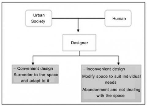
Residents of slums tend to be socially isolated from urban areas, but they can integrate into the labor market [18]. Crime and delinquency are high in slums because of poverty, lack of education, and cultural awareness. Residents of slums suffer from low income due to high unemployment rates. The urban spaces for humans consist of relationships between individuals, social institutions, and society in general. Figure 5 illustrates this relationship. The spaces are responsible for achieving the desired goals and values of society. Looking at two main issues: the behavioral responses of the population, where working on modifying the spaces to suit the needs of the population, abandoning the space, not interacting with it, and giving in to the void, the desired goals when building urban spaces, where achieving the outputs that were intended for the design process, whether material or moral, formation Spaces in a way that makes them content for various activities and design according to the characteristics, and these characteristics are useful in shaping the urban space because it is related to the man psychological processes [19].
Figure 5. The relationship between human behavior and the urban and designer community and its results
Source: [20]
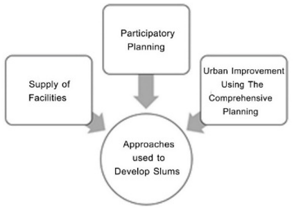
5.5 Approaches used to develop residential areas to replace slums
We will divide the types of development approaches into two main axes, in residential areas to replace slums. Figure 6 is an explanation of the most important points in these approaches, and the first axis: is a theoretical axis, which is concerned with creating an explanation for all planning and design work during and before its identification to reach the design foundations needed for the development As for the second axis: an experimental axis, as it is concerned in this axis on how to apply, practice and evaluate to know the advantages and disadvantages and from all these studies from the ground and experience to determine the appropriate method for implementation. One of the most important problems that this axis faces is that it will only sustainably guarantee development in a logical and organized form of the stages of development and its implicit steps, with an appropriate time plan.
Figure 6. Approaches used to develop slums
Source: The researcher's work
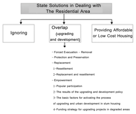
5.6 The policies adopted by Egypt to deal with informal residential areas
Figure 7. Policies followed by the state to deal with slums
Source: The researcher's work
The state has followed three basic policies used in the development of slums. Figure 7 shows the three policies that the state handles.
5.7 The proposed urban development approach in residential areas to replace slums to achieve sustainability
As a conclusion from the previous studies, a comprehensive approach can be put forward for the foundations of development in slum residential areas that are compatible with the idea of urban development and sustainable development, and Figure 8 is an illustration of these methods.
Figure 8. Approach to sustainable urban development
Source: [21]
The urban residential environment is commensurate with the behavior in the slums, so this approach takes two necessary directions: a social development approach and an urban development approach [22].
5.8 Obstacles to achieving sustainability through landscaping in residential areas to replace slums
The landscape in slums was affected as a result of neglect and random construction due to many points, namely the destruction of the green belt of cities, the lack of basic health conditions and standards in housing, the lack of equipment necessary for sanitation in slums, and the lack of natural ratio between built-up areas and green areas.
And then, the random housing turns into the most dangerous area, and its balance is disturbed due to the increase in the cement buildings, the lack of good ventilation, and the lack of healthy and sustainable housing conditions.
5.9 Influences that help achieve sustainability in residential areas to replace slums through landscape
Random areas are formed due to the random method prevailing in these areas and lead to several risks, including environmental, social, and security. This prompts us to evaluate and measure the influences contributing to reforming slums by sustainably coordinating the site. These influences are:
Environmental influences: Optimum planning in slum areas must be developed, modified, and adhered to. Plants must be taken care of, and suitable trees and grass must be selected and their quantities determined. Industrial areas must be kept away from buildings and open areas not to affect the environment and the purity of their air.
- Social influences: spreading awareness of the importance of green spaces that help residents to communicate and feel psychological comfort between each other and in their area, spreading awareness of the importance of various trees and not affecting or cutting them down, and distinguishing the importance of these trees in the sustainability of slums, clarifying the importance of residential growth within urban planning To show the right of residential areas and green areas in the place and that they complement each other.
- The Urban influences: adherence to the policies regulating land division, preparing studies that determine and reduce the random extension of the settlements within a specific time [23].
5.10 Principles for achieving environmental sustainability through landscaping in residential areas to replace slums
The foundations for achieving environmental sustainability vary in terms of the landscape into several areas, and they are:
1- Location: It is divided into managing wastewater, rainwater, and floods; enhancing the ecosystem; evaluating and preserving the aquatic ecosystem and protecting wildlife; environmental management of the construction phases; the location within the areas under the development map; connection to various and multiple transport networks.
2- Water: It is divided into measuring water efficiency, alternative water solutions, reducing water consumption, managing rain on site, reducing water use in irrigation, designing functional elements to benefit from rainwater in services, and restoring the water ecosystem.
3- Energy: It is divided into experimental operation of sustainability systems, energy performance, renewable energy, installation of site cover, measurement of energy consumption, and impact on the ozone layer.
4- Soil and vegetation: It is divided into the use of appropriate plants, the maintenance of soil health and the use of appropriate vegetation cover, the control and management of invasive plants, the use of plants of a special nature, the use and preservation of local plants, the establishment of a soil management plan, the reduction of the effect of heat islands, the reduction of plant fire hazards.
5- Selection of materials: It is divided into maintaining site structure and paving, eliminating the use of wood from endangered trees, reusing recycled materials, supporting the use of safer materials, using local and regional materials, and designing for adaptation.
6- Maintenance operations: It is divided into having a site maintenance plan, recycling organic materials, reducing the use of fertilizers, pesticides, and pests, storing and collecting recyclable materials, using renewable energy sources to meet site electricity, and protecting air quality during site maintenance.
7- Health and human well-being: It is divided into supporting the restoration of morale, supporting community communication, protecting and maintaining cultural and historical places, promoting fair use of the site, providing easy access, safety and security to the site, supporting physical activity, reducing exposure to smoking, supporting the local economy, providing on-site production food, reducing light pollution, thermal comfort on-site.
5.11 Methodology for assessing sustainability through landscape in residential areas to replace slums in Egypt
Sustainability assessment through the landscape is divided into several levels, in which the different levels of sustainability are assessed, the objectives of achieving sustainability are assessed, and the strategies proposed to achieve sustainability are evaluated, and these levels are:
Rationalizing water consumption in landscaping the site, the extent to which energy is rationalized in landscaping the site, achieving vitality in the climate through landscaping the site, the extent of the effect of fertilizers and pesticides used in landscaping the site, the extent to which water quality is achieved in residential areas through landscaping.
The second level: is the social dimension of sustainability through site coordination: the extent of providing privacy through the spaces and elements of site coordination, the level of human health and the extent of its improvement through site coordination, how to benefit from recycling organic waste extracted from residential areas and using them in site coordination, the importance of aesthetic views By coordinating the site and its importance to increase acceptance among users in residential areas.
5.12 The expected results of achieving sustainability through landscaping the residential areas to replace the slums
- The effect of green spaces on solar radiation
- The effect of green spaces on air movement
- The effect of green spaces on Humidity
- The effect of reducing energy consumption and production
- The effect of rationalizing energy use
- The impact of using energy resources and technologies with a sustainable environmental dimension.
The urban growth in our current time tends towards the slum areas; there are many reasons for choosing projects, whether global or local; for analysis, the global and local projects were chosen based on their being slum areas, and they were developed due to the importance of these areas, their size, the extent of deterioration they reached, then the development and stages of their growth, the main objective is to verify the availability of standards and principles for environmental sustainability through the landscape, After the analysis, the positives and negatives resulting from the replacement of global and local projects were shown as shown in Table 3.
6.1 The first project: The Dharavi area project in Mumbai, India
Dharavi is one of the most famous slum areas, as it is the second largest slum area in Asia after the city of Orange in Pakistan and is the third largest slum area in the world. The Dharavi region arose due to the transfer of factories and residents from the city center to its outskirts in the year 1882 AD, and as a result of the migration of rural people to the urban Mumbai area, and there was no government plan to invest in the region or plan, so it established housing and factories randomly until it became within Mumbai, as Mumbai, the capital of the state of Maharashtra, has a high economic, commercial and cultural center and is considered one of the largest cities in the world, with an area of 344 km [24]. Figure 9 illustrates the location of the region.
- Elements of project analysis: Funding in the Dharavi project development plan was based on the private sector instead of government funding or international funds, establishing initial feasibility for the public and private sectors to obtain incentives to cover the costs of building residential towers while achieving additional profit from commercial centers and multi-use buildings with the provision of spaces for entertainment Providing industrial parks, golf courses, a sports complex, and hotels.
- The landscape problems that the project suffers from: include the lack of surveying of the area, which led to the lack of surveying the infrastructure of what has become. It is not possible to adequately assess the strategies for land use, the lack of community awareness of the rehabilitation plan of the project, and the lack of linkage between the infrastructure development plan in Mumbai and the infrastructure in Dharavi.
- As a result of user and beneficiary participation in designing the project to achieve the sustainability of the site coordination: the absence of community participation at the beginning, and then a new proposal is reached until the participation and the project plan in the area are democratically reached.
Figure 9. Dharvi District location
Source: [25]
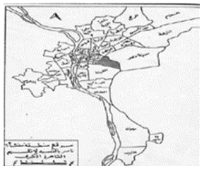
6.2 The third project: Manshiyet Nasser area in Cairo
Until recently, the area was used as quarries to extract limestone in the Fatimid era. After that, at the beginning of the year 1960 AD, the area's reconstruction began. Some of those who were excluded from the nests near the city center and some of the displaced residents of Upper Egypt and the residents of the canal cities as a result of migration began to live. The best, and number and density of the population in the region continued to increase until 1972 AD. The Cairo Governorate decided to house the garbage collectors in a part of the facility in a neighborhood later called the Zabbaleen neighborhood. Attractive Due to its central location in Cairo and low rents, the project was included as a slum housing development area [26]. Figure 10 shows the location of the area.
- Landscape problems that the project suffers from the presence of wasted areas due to the failure to exploit the level differences in the land, the lack of a suitable sewage network for the project land as a result of the topography of the site, which negatively affected the infrastructure and the structural condition of the buildings.
- Sustainability standards that were applied in coordinating the site for the project:
• Improving sanitation and infrastructure.
• Reducing the rates of encroachment and random construction by participating in the community and activating the law.
• Working on transferring garbage from construction and housing areas to other remote areas to purify the air in residential areas after a climate study for the site.
- As a result of the participation of the user and the beneficiary in designing the project to achieve the sustainability of the site's coordination: the users were not involved in the project, so the urban side was taken care of by improving the infrastructure, streets, paving and sanitation, and the housing and the needs of the individual users were not taken care of.
Figure 10. The location of the Abdel Nasser facility in the Cairo region
Source: [27]
Table 3. Comparison of the most important pros and cons of replacing previous projects
|
Project |
Dharavi area project in Mumbai, India |
Manshiyet Nasser area in Cairo |
|
Project type |
Random housing development by substitution. |
Slum development. |
|
Location |
The city of Mumbai is affiliated with Maharashtra in the State of India. |
It is located within the neighborhoods of the Western Region in Cairo Governorate, near the center of Cairo. |
|
The site area |
2.4 km2 |
850 acres |
|
Advantages of project |
1- Bringing together the different cultures and religions in the region within a single social fabric. 2- Preserve the mangrove forests adjacent to Dharavi and nature. 3- Providing sources of income for the poor as a result of the economic contribution of the informal city. 4-The presence of historical buildings on the site, such as Rewa Castle and tourist areas. 5- The possibility of activating innovative concepts in maintaining traffic networks and transportation. 6- The existence of an educated and conscious generation keen on educating children. 7-Ensuring the region's development and a sense of the region's identity. 8-Upgrading the region the function of the region as a business incubator can be enhanced by taking advantage of the business environment and small projects on the site. 9-Improving environmental awareness, reducing pollutant sources and developing community culture. 10-Diversity of environmental resources and proximity to open areas. 11-Providing sustainable industrial activity by organizing and expanding the recycling center and choosing the appropriate location. 12-The solidarity of the population led to decreased crime rates. 13-Supporting community participation, social networks, and non-governmental organizations. 14- A high-value site due to its strategic location and proximity to Mumbai city center. 15- Achieving visual diversity because all buildings are of different heights and colors. 16-Creating sustainable social development and improving the social situation for future generations. |
1- Residents' cooperation with the planning and implementing agencies and their understanding of the development process. 2- Non-centralization of services so all residents in the new area can easily use them. 3- Due to the proximity between the old and the new area, it became easy to maintain links between the residents of the two areas. 4- Appropriate housing needs and capabilities of the implemented housing models. 5- Attention was paid to the urban character of the region in terms of facades, elevation, and external finishes, which led to a high civilizational shift in the population. 6- Designing the external spaces between the residential buildings as squares and recreational areas for the residents. 7- Preserve real estate wealth in the old area by removing deteriorated buildings only. 8- Focusing on developing the special capabilities of the population and providing them with job opportunities through coordinating small environmentally friendly projects. 9-Designing a network of roads with a gradual flow of traffic and internal streets that allow the entry of ambulances and firefighting vehicles in cases of emergency and for security control over the area. 10- Dividing the project into multiple stages and defining the appropriate thinking for planning with the participation of users and the planning and executing agencies. |
|
Negatives of project |
1- Traffic congestion and pollution (audio, visual and environmental). 2- Health problems and noise problems. 3- Hazardous industries and industrial pollution. 4- Difficult living and working conditions. 5-The danger of fires and the difficulty of extinguishing them. 6-Natural ventilation is difficult in existing houses. 7- Poor basic infrastructure and public utilities. 8- Trying to move people to live outside Dharavi as pressure as a result of the government plan. 9- Forming pressure for redevelopment due to the proximity to the financial and commercial complex. 10- The percentage of the poor is high among the population. 11-The danger of flooding in the lowlands. 12- Lack of interaction between government and society. 13-The site is difficult to access, which led to its isolation. 14-Lack of adequate community facilities due to poor infrastructure. 15-Not was defining a legal status for many people. 16-The topographical shape and the contouring nature of the area led to the difficulty of emergency access. |
1- The inability of the residents to pay the monthly installments due to the lack of a fixed income, because in the past, they were not required to pay the monthly installments in the slum area. 2- Some residents encroached on the residential buildings by closing the balconies on the lower floors and turning them into small shops for trade to provide a source of income due to the low income. The project follow-up office must continue the follow-up, and its role in preserving the project as it was implemented should continue. |
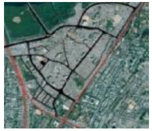
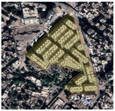
The area of Rawdat al-Sayeda Zeinab, known as (formerly Tal al-Aqrab) in Cairo, was considered one of the unsafe slums, and its danger was classified as second-class (which means inappropriate housing), so it was necessary to replace the area and resettle it in the same location because of its many considerations.
- Location: Tal Al-Aqrab is located in the Al-Sayeda Zeinab neighborhood in Cairo. The area is bounded from the east by Bayram Al-Tunisi Street, from the west by Al-Sad Al-Barani Street, and to the south by the Armenian Catholic cemeteries and Al-Jazzar Street. Figure 11 illustrates the horizontal projection of the area.
- Area: 8.5 acres.
In 2013, there was an agreement between the Cairo Governorate and the Informal Settlements Development Fund to prepare a development plan. This plan was based on the complete removal of buildings and the provision of alternative housing until the development was completed on the site. From 2015 to 2019, the area's residents moved to temporary housing 50 km from West Cairo; then, the planning began for the area. After leveling it to the ground, 3,264 families returned to the area at the end of summer 2019. Rawdat Al-Sayyida became the first area where residents in the region returned within the government's plan to develop slums [28], Environmental sustainability was assessed according to Landscape in the region through several fields, including location, water, energy, soil, vegetation cover, selection of materials, maintenance operations, health and human well-being, as shown in Table 4.
Figure 11. Rawdat Al Sayeda area
Source: [29]
Table 4. Environmental sustainability assessment through landscaping elements in Rawdat Al Sayeda Zeinab District, Cairo
|
Field |
Reflection on achieving the requirements of the elements of landscape |
The method of evaluating the requirements for achieving environmental sustainability on the site |
Requirements for achieving environmental sustainability |
Exist |
None |
|
|
Acceptable |
Not acceptable |
|||||
|
Site |
1 - Sewage, Rain, and Flood Water Department. |
- A plan for wastewater treatment. |
- Either relying on obtaining water from wastewater treatment stations designated for this purpose or the availability of these stations in the region. |
|
|
• |
|
- A plan for managing rainwater and placing it within a plan for rainwater redirection or filtration. |
- Providing rainwater collection systems, whether through: permeable and absorbent floors, biological filters, reservoirs in the infrastructure, irrigation pumps from rainwater, or rain barrels. |
|
|
• |
||
|
2- Enhancing the environmental system. |
- Improving soil properties and protecting them, reducing the need for resources, and reducing maintenance conditions. |
- Leaving crop residues and remnants has a great role in protecting the soil surface from other influences. |
|
• |
|
|
|
3- Evaluating and preserving the aquatic ecosystem and protecting wildlife. |
- Clarify the development map included in the site and the system for determining the wealth of the site. - The presence of a periodic report to assess the environmental system at the site. |
- The following assets are invaluable: lands of natural value important to society, environmental or cultural heritage assets, including healthy native trees or shrubs, and species that the International Union for Conservation of Nature (IUCN) has warned to protect or are critically endangered. |
|
|
• |
|
|
4- Environmental management of the construction phases. |
- This administration's role is to address the environmental and social impacts after the construction process. |
- Using materials extracted, processed, and manufactured within the region (homemade) in site coordination. |
• |
|
|
|
|
- Use non-potable water in construction operations, such as secondary gray or black water treatment. |
|
|
• |
|||
|
5- The location within the areas under the development map. |
- The site's location within the areas included in the development course. |
- The site's dependency on the strategic plan for the city's development. |
• |
|
|
|
|
6- Connecting to various transport networks. |
- A network of pedestrian and bicycle paths. |
- Measure the safe walking distance from the pedestrian entrance to the entrance to the parking lot or the parking station. |
• |
|
|
|
|
- The site is connected to the public transport network. |
- The walking distance is assessed as "safe" when constructing a road along the pedestrian lane with a width of at least (1.8) meters and equipped with safe crossing points such as traffic lights, stop signs, or designated pedestrian crossing points. |
• |
|
|
||
|
|
- The road must run in both directions. |
• |
|
|
||
|
Water |
1-Measurement of water efficiency. |
- Measurement of water tools. |
- Irrigation zones should be planned by combining plants with similar water use. |
|
• |
|
|
- Explain irrigation schemes and methods of controlling them. |
- The use of local plant species to strengthen the ecosystem. |
• |
|
|
||
|
- Clarifying the specifications of the irrigation system. |
|
|
|
• |
||
|
2- Alternative water solutions. |
- Water condensation. |
- Condensate water recovery with on-site reuse for flushing latrines or irrigation HVAC systems. |
|
|
• |
|
|
- Gray water recycling. |
- Collect and recycle gray water from showers, tubs, clothes washers, and dishwashers for on-site use for flushing toilets or irrigation. |
|
|
• |
||
|
- Treated wastewater. |
- Treating at least 50% of the wastewater on-site and filtering or using it on-site for irrigation. |
|
|
• |
||
|
3- Reducing water consumption. |
- Reducing the use of external water. |
- Rationalization in the use of potable water for irrigation. |
|
• |
|
|
|
- Install water meters to measure consumption. |
- They must be in a sealed location, not manually adjustable, and give clear readings. |
• |
|
|
||
|
4- On-site rain management. |
- By collecting rainwater through drainage pipes, filtering it, recycling it, and using it on site. |
- Retaining 100% of rainwater through large underground reservoirs or other methods such as porous and absorbent floors, biological filters, irrigation pumps, rain gardens, and water tables. |
|
|
• |
|
|
5- Reducing the use of water in irrigation. |
- Operation of irrigation-saving systems
|
- Irrigation system with sprinklers of potable water. |
• |
|
|
|
|
- Reusing muddy water after recycling it. |
|
|
• |
|||
|
6- Designing functional elements to benefit from rainwater in services. |
- Using a large proportion of rainwater in services. |
- Use a ratio of 50% of rainwater in collection systems. |
|
|
• |
|
|
7- Restore the aquatic ecosystem. |
- Existence and development of an aquatic ecosystem at the site. |
- Preserving natural water places such as ponds and lakes on site. |
|
|
• |
|
|
Energy |
1- Trial Operation of Sustainability Systems. |
- Controls the operation of sustainability systems through lighting controls, water systems inside the site, metering, and renewable energy systems. |
- All systems and controls installed and operating as intended, operation certificates, list of installed systems, and operation and maintenance instructions are included in a sustainable manual. |
• |
|
|
|
2- Energy performance. |
- A simulation program to perform the necessary calculations to measure the energy loads needed at the site. |
- The correct climatic zone for the project site must be considered. |
|
• |
|
|
|
3- Renewable energy. |
- Using solar energy for lighting on site.
|
- Renewable energy systems should be designed using certified simulation software that provides more accurate calculations and leads to better system design. |
• |
|
|
|
|
- Electricity production on site. |
- Size, number, and type of solar panels and photovoltaic energy. |
• |
|
|
||
|
4- Installation of site cover. |
- This operation concerns condensation, air infiltration, heat blocking, and water entry into the site. |
- Conducting air tightness tests and detecting thermal dams (thermal imaging). |
• |
|
|
|
|
- Test the building envelope to ensure design performance following ASTM Standards such as Condensation, E779: Water entry, air infiltration, and thermal dam. |
|
|
• |
|||
|
- All installed products, including customized cladding systems, receive a pre-test certificate. |
|
|
• |
|||
|
5- Measurement of energy consumption. |
- Through the meters that measure electricity, these meters must be in tightly closed places, have clear readings, and do not have any function in changing the readings manually. |
- Considering all energy sources in the sub-measurement strategy. Any alternative sources, such as on-site energy production, liquid fuels, gaseous fuels, or waste-to-energy systems, should be identified and considered in the strategy. |
|
|
• |
|
|
- Ensure that at least 90% of the total energy requirement is on site. |
|
• |
|
|||
|
6- The effect on the ozone layer. |
- Banning the use of CFCs or halon-based materials. - It must be ensured that the materials used in the site of maintenance gases and fire suppression systems have an ozone depletion coefficient of zero. |
- The use of natural refrigerants in the various elements of site coordination, such as carbon dioxide, ammonia, air, water, and propane. |
|
• |
|
|
|
Soil and vegetation |
1- Using suitable plants. |
- By researching and checking the types of plants suitable for the soil, which are easy to adapt to the surrounding environment through research and analysis. |
- Cultivating plants suitable for the type of soil in the site. |
• |
|
|
|
2- Preserving soil health and using suitable vegetation cover. |
- Depending on the percentage of the cultivated area in the site. |
- The percentage of green land must be at least 50% of the site area. |
|
|
• |
|
|
3- Monitor and manage invasive plants. |
- Following up on the growth of invasive plants and plants that grow randomly, such as weeds. |
|
|
|
• |
|
|
4- Use plants of a special nature. |
- Plants of a special nature must be introduced in green areas. |
- The presence of special natural plants raises the site's sustainability assessment. |
|
|
• |
|
|
5- Using and preserving local plants. |
- The percentage of local plants should be at least 100% of the plants used. |
- The use of grass, trees, palms, and ornamental plants of local origin and through plant groups or any plant grouping balanced with the surrounding environment. |
|
|
• |
|
|
6. Create a soil management plan. |
- A plan must be developed to monitor and maintain the soil periodically to obtain healthy and sound soil |
- Use plants suitable for the soil type. |
|
• |
|
|
|
7- Reducing the effect of heat islands. |
- By using vegetation cover, green spaces, green roofs, and reducing air pollution, the vegetation cover percentage is less than 50%. |
- The site's design contains green areas, trees, and plants that impact climate. |
|
|
• |
|
|
8- Reducing the risk of plant fires. |
- Providing safety means for protection in the event of fires. |
- There are places designated for fire extinguishers that are easy to reach. |
• |
|
|
|
|
Material selection |
1- Maintain site structure and paving. |
- The site infrastructure should be taken care of, and good paving should be checked. |
- Integrating the basic infrastructure with the natural situation of the site and studying it in an environmentally friendly manner. |
• |
|
|
|
2- Eliminate the use of wood from threatened trees. |
- Not to use wood from endangered trees to preserve and protect them. |
- Developing the necessary laws to manage the site by preventing the use of any wood from endangered trees in the elements of site coordination. |
• |
|
|
|
|
3- Reuse of recycled materials. |
- The percentage of used materials is at least 40% recycled away from soil and plants. |
- Providing a waste separation system through waste bins on site. |
|
|
• |
|
|
4. Support the use of safer materials. |
- Safe chemicals must be used.
|
- It must not include chlorofluorocarbons or hydrochlorofluorocarbons in its manufacture. |
|
• |
|
|
|
- Monitor and support environmental risk assessment. |
- The ozone depletion coefficient should be zero, and the global warming potential should be less than five. |
|
|
• |
||
|
5. Use local and regional materials. |
- Most of the materials used should be local. |
- The presence of a monitoring system on site to ensure the locality of the materials used. |
• |
|
|
|
|
6. Design for adaptability. |
- The economy in the use of materials. |
- Using the remaining materials from construction and restoration to be reused in corridors and squares. |
|
|
• |
|
|
Maintenance operations |
1- Having a site maintenance plan. |
- Develop a detailed plan and Maintenance periodicity. |
- Follow-up of maintenance operations for squares and green spaces through a team of engineers. |
|
• |
|
|
2- Recycle organic materials. |
- The presence of an on-site system for recycling agricultural waste and using it as fertilizer. |
- Managing organic waste systems and finding special centers for recycling. |
|
|
• |
|
|
3- Reducing the use of fertilizers, pesticides, and pests. |
- Create a plan for healthy plants. |
- Use organic fertilizers and reduce chemical fertilizers |
|
|
• |
|
|
4- Storage and collection of recyclable materials. |
- Waste management plan. |
- Collecting recyclable materials on site according to a pre-planned plan. |
|
|
• |
|
|
5- Using renewable energy sources to meet the electricity of the site. |
- Relying on renewable energy to a large extent to meet the site's electricity needs. |
- Use 100% of the site's electricity from renewable energy sources. |
|
• |
|
|
|
6- Protect air quality during site maintenance. |
- Reducing pollution resulting from maintenance operations. |
- Use of manual maintenance equipment. Use maintenance equipment with low emissions. |
|
• |
|
|
|
Health and human well-being |
1: Support the restoration of morale. |
- Provide visual and physical contact between users and the site. |
- Designing large green spaces and open spaces |
|
• |
|
|
2- Supporting community communication. |
- Providing outdoor seating to create a quiet social atmosphere. |
- Arranging the seats in a way that allows for conversation And communicating with others easily. |
|
• |
|
|
|
3- Protection and maintenance of cultural and historical places. |
- The cultural and historical heritage must be preserved in the site's landscaping. |
- Not to demolish any historical building on the site and to preserve the heritage cultural buildings. |
• |
|
|
|
|
4- Promote fair use of the site. |
- Distributing landscape elements fairly and providing all activities to users. |
- Each element of the site's coordination is designed according to the percentage allowed for it. |
|
• |
|
|
|
5- Provide easy access, safety, and security to the site. |
- Placing lighting poles, fire extinguishers, and guiding signs on site |
- Provision of parking spaces, locations of service controls, and how close pedestrian walkways are to entrances. |
• |
|
|
|
|
6- Support physical activity. |
- Creating spaces for sports activities. |
- Sports courts: such as football and basketball. |
|
|
• |
|
|
7- Reducing exposure to smoking. |
- Banners for the prohibition of smoking on the site |
- the imposition of fines for smoking by the on-site administration. |
|
|
• |
|
|
8- Supporting the local economy. |
- Providing job opportunities at the site from the beginning of construction to the maintenance stage. |
|
|
• |
|
|
|
9- Providing food production at the site. |
- Planting trees with edible crops of all kinds. |
- Managing food production and its regular distribution. |
|
|
• |
|
|
10- Reducing light pollution. |
- Provide night lighting based on solar energy and use electricity bulbs. |
- Lighting poles based on solar energy. |
• |
|
|
|
|
11- Thermal comfort on site. |
- Develop a strategy for thermal comforts, such as prevailing winds and seasonal weather. |
- Provide 50% shading cover at the front entrances, patios, and courtyards. |
|
• |
|
|
|
- Providing umbrellas in seating areas, parking lots, and pedestrian walkways. |
- Determine the opposite solar materials. Provide a shade cover of at least 75% in pedestrian walkways, playgrounds, and car parks. |
|
• |
|
||
Source: the researcher's work
Based on the results of the previous Table and based on the collection and analysis of information and data according to the current situation through the definition of the region, borders, topography, location, and historical development, the study concluded the extent to which sustainability matches the region in terms of location: ease of access and connection with the surrounding areas in a good way and the deterioration of the ecosystem in the current situation What it was after development, infrastructure: water, sewage, electricity, and renewable energy is acceptable, but there is no control over the operating system for sustainability systems. The region's impact on the ozone layer has yet to be addressed. As for local resources: well used, plants: the percentage of local plants is 60%, and the green areas need continuous follow-up. Maintenance: it does not take place within a periodic plan. As for the general planning of the area, it achieves visual and social communication. The three architectural models meet the needs of users. The area lacks architectural spaces in a way that achieves thermal comfort. As for services, basic services are available.
The general picture: the area is acceptable, and because the project is based on replacement, it lacks the social and economic dimension, and it is concerned with the urban dimension and the improvement of housing, which means that the area after the replacement still needs to achieve environmental sustainability through a landscape fully.
The researcher concluded that the sustainability of the residential areas in the slums after their replacement and development to several standards and basic principles are concentrated in the following:
- Environmental sustainability by using renewable energy, recycling waste, benefiting from local resources, and preserving the natural environment.
- landscape by studying it and studying the nature and behavior of users while meeting their needs and paying attention to studying spaces as a function, furniture elements, and the diversity of plant elements.
- Disseminate the policies necessary to implement sustainability through experiences and plans commensurate with the population increase, as well as popular participation to reach the positives and negatives to benefit from them.
Integrating the urban and social aspects and the availability of educational, commercial, health, and entertainment services.
- Legislation, laws, financial support, awareness raising, behavior improvement, availability of infrastructure in a satisfactory manner, and appropriate planning and design of housing units for needs.
- Exploratory studies should be relied upon to study the current situation.
- Encouraging effective public participation and keeping pace with continuous development.
- Attention not to infringe on the architectural style of buildings.
- Ensure that income levels do not drop and unemployment increases.
- Thinking about the possibility of future expansion.
- Paying attention to the social dimension and improving housing.
- The availability of services and the connection of the area with the surrounding areas and internal streets are good because there is no passing traffic.
Paying attention to waste recycling led to achieving some principles of environmental sustainability.
Paying attention to the economic dimension so that it does not lead to unemployment.
- Green areas should be increased.
- The need for spaces to be compatible with the high population density to reach community cohesion.
Through the research, it was identified what is sustainability and what are its principles and standards that must be achieved in any region in order to reach an integrated sustainable world and what are the residential areas and what are their types and the reason for choosing the random areas that were replaced for the study and what is landscape and its elements and the foundations of its design and how to raise the efficiency of the area Residential through it and the analysis of landscape of residential areas that have been replaced and the impact of the design of landscape in the region on the residents and their behavior and the comparison between local and international experiences.
Through the study of the previous study, it was found that it lacks the integration of landscape with environmental sustainability and sustainability in general, but only includes the study of sustainability on different buildings, whether they are residential, commercial or administrative, and how to apply the principles of sustainability in the design of these buildings. Aesthetic only and how to plan it in an engineering manner, but it did not include the integration of both environmental sustainability and landscape to reach a sustainable area that improves the behavior of its residents and makes them feel reassured and calm, and the random areas were not chosen after the replacement in terms of sustainability, but rather in terms of the design of the buildings and the psychological of the population, but the research focuses on collection Between each of the site coordination, environmental sustainability and slums after settlement, to reach an environmentally sustainable residential area through landscape.
By studying the above and integrating the various principles of environmental sustainability with the elements of landscape and reaching several requirements that must be achieved in landscape through The site, energy, water, soil and materials made from it are elements of site coordination, maintenance operations, health and human well-being, and the application of this system to the Rawdat Al-Sayyida Zainab area in Cairo, as it is a random area that has been replaced and has the characteristics included in the research, and then to identify the deficiencies in landscape in the area and how to fix it, and there Some points that must be adhered to when designing residential areas in Egypt to achieve environmental sustainability according to the principles to the following criteria:
- The availability and consistency of open spaces with the surrounding buildings, such as residential buildings, roads, commercial buildings, and mixed buildings in many of the slums that have been replaced.
Landscaping is an essential part of the urban environment because it has an effective and effective role in the needs of the population, whether they are human, aesthetic, or functional needs.
- Being able to develop an assessment of environmental sustainability in residential areas by coordinating the site for previously replaced areas to find out the pros and cons.
- The slums in Egypt that have been replaced need many basics that must be focused on when sustainably designing their site.
The study discusses the random residential areas after the settlement, because of the importance of these areas in terms of the region geographically, socially and economically, and that these points must ensure the sustainability plan through landscape, so that the system that was developed can improve the behavior of the population and preserve their area after the replacement and its sustainability. And it was applied to the Rawdat Al-Sayeda area in Cairo.
It is suggested that future studies on the application of this system be through artificial intelligence, whereby the design of the landscape of the region and data for the elements of landscape and the requirements for the application of sustainability can be entered in it, and then the existing shortcomings in the planning of landscape in this region can be obtained.
[1] Colin, A. (2005). Le Developpement Durable. France, Ouvrages.
[2] Godrad, O. (2006). L’Entreprise Economique Du Developpement Durable-Enjeux Et Politigues De L’Environnment, France.
[3] Legoix, R. (2005). The impacts of gated communities on property value: evidence of changes in real estate markets-Los Angeles. https://doi.org/10.4000/cybergeo.6225
[4] Bousselot, J.E. (2006). Sustainable Landscaping. Cooperative Extention-Horticulture (CSU). Colorado State University. https://www.ext.colostate.edu/pubs/garden/07243.html.
[5] Lerario, A. (2022). The role of built heritage for sustainable development goals: From statement to action. Heritage, 5(3): 2444-2463 https://doi.org/10.3390/heritage5030127
[6] Kardoush, H. (2014). Strategies for sustainable planning of land uses and the use of available resources in the regions of Hamra and Hreitan. Aleppo University.
[7] Ministry of Public Works in the United Arab Emirates. (2011). Urban standards guide for residential neighbourhoods. The United Arab Emirates: Ministry of Public Works in the United Arab Emirates. https://www.mopw.gov.ae.
[8] Amin, T.A. (2001). Landscape operations. Architectural Engineering Department, Cairo University. Cairo: Architecture, Cairo University, https://books.google.com.eg/books/about/%D8%AA%D9%88%D9%81%D9%8A%D9%82_%D8%B9%D9%85%D9%84%D9%8A%D8%A7%D8%AA_%D8%AA%D9%86%D8%B3%D9%8A%D9%82_%D8%A7%D9%84.html?id=TUOEQgAACAAJ&redir_esc=y.
[9] Morsy, S. (2020). Strategic and Sustainable land use planning of coastal sites in Egypt. Journal of Nuclear Technology in Applied Science, 8. https://doi.org/10.21608/JNTAS.2020.20542.1011
[10] Muhammed, S., Al-Bulayhy, H. (2016). Urban spaces in the Egyptian city between theory and practice. College of Engineering, Sina University, Cairo, 11(39): 856-872. https://doi.org/10.21608/AUEJ.2016.19436
[11] Dursun, P. (2009). Architects Are Talking About Space. Turkey: Istanbul Technical University.
[12] Suleiman, M.A. (2003). An approach to beautify the visual environment of the Arab city, a case study of Kuwait City. Ain Shams Engineering Journal, 38(4): 1110-1385.
[13] Yahia, M.W., Johansson, E. (2014), Landscape interventions in improving thermal comfort in the hot dry city of Damascus, Syria—The example of residential spaces with detached buildings. Landscape and Urban Planning, 125: 1-16. https://doi.org/10.1016/j.landurbplan.2014.01.014
[14] Hamed, M.S. (2018). A vision towards an effective housing policy for low-income people in Egypt. Evaluation of the social housing program in the new cities. Journal of Urban Research, 27(1): 65-82. https://doi.org/10.21608/JUR.2018.88394
[15] Sheikh, K.M.M. (2014). Manifestations of environmental coexistence in functional societies: An analytical study of the Zabbaleen area in Manshiet Nasser. https://publication.cpas-egypt.com/journal_article/%D9%85%D8%B8%D8%A7%D9%87%D8%B1-%D8%A7%D9%84%D8%AA%D8%B9%D8%A7%D9%8A%D8%B4-%D8%A7%D9%84%D8%A8%D9%8A%D8%A6%D9%8A-%D9%81%D9%8A-%D8%A7%D9%84%D9%85%D8%AC%D8%AA%D9%85%D8%B9%D8%A7%D8%AA-%D8%A7%D9%84%D9%88/#.
[16] Essam, A. (2015). Spatial digraph at the room level of sequina slum area in Alexandria Egypt. In Third International Conference on Advances in Applied Science and Environmental Technology, Bangkok, Thailand, 28-29 December, 2015, pp. 36. https://doi.org/10.15224/978-1-63248-084-2-36
[17] Al-sayed, S. H. (2021). The role of strategic planning in spatial competing between planned and unplanned urban areas (Case study: Urban areas of Greater Cairo). Journal of Engineering Sciences, 49(6): 7. https://doi.org/10.21608/JESAUN.2021.66281.1037
[18] Suleiman, M.A.D. (2010). Positive aspects of the growth of slums (development approach). Cairo - Arab Republic of Egypt: Faculty of Engineering, Shubra. https://bu.edu.eg/portal/uploads/Engineering,%20Shoubra/Architectural%20Engineering/681/publications/Mohammed%20Ahmed%20Soliman%20%20Muawwad_paper_06.pdf.
[19] Kasab, A.S. (2012). Towards a socially effective residential environment in contemporary residential architecture. Journal of Engineering and Applied Sciences, 1(35): 256.
[20] Mourshed, M. (2006). Interoperability-based optimisation of architectural design, National University of Ireland, Cork, Ireland, https://doi.org/10.13140/RG.2.1.2764.1845.
[21] Suleiman, M.A. (1996). Urban formation and design standards for city centers. Zagazig, Arab Republic of Egypt: Zagazig University. http://srv4.eulc.edu.eg/eulc_v5/Libraries/Thesis/BrowseThesisPages.aspx?fn=ThesisPicBody&BibID=9638676&TotalNoOfRecord=364&PageNo=14&PageDirection=Next.
[22] Campbell, D. (2007). Landscape design considerations in large scale forestry operations in Great Britain. Planning Outlook, 20(2): 1977-1983. https://doi.org/10.1080/00320717708711539
[23] Stauskis, G. (2020). Identifying key criteria for quality assessment of landscape architecture projects. Architecture and Urban Planning, 16(1): 5-11. https://doi.org/10.2478/aup-2020-0002
[24] Mumbai Population. (2019). https://worldpopulationreview.com/worldcities/.
[25] https://www.google.com/earth, accessed on Jan. 12, 2023.
[26] Abdel-Ghany, A.A. (2007). Toward a methodology of defining stakeholders and their roles in urban upgrading projects. Journal of Engineering Sciences, Assiut University, 35(2): 569-596. https://jesaun.journals.ekb.eg/article_112869_a3403cb06fecbd0ccc934d6c3575c20f.pdf.
[27] Nazmy, N.M., Abdullah, S.S., Kamel, H.S. (2007). The development of slums as a model for compatible housing in Egypt, a case study in the Manshiyet Nasser area in Cairo. Arab Republic of Egypt, Al-Azhar University Engineering Journal, 2(8). http://swideg-geography.blogspot.com/2017/11/blog-post_2.html.
[28] Ahmed, A.E. (2016). Rawdet El-sayeda Zainab step in the way of developing slums, Cairo. Arab Republic of Egypt: Environmental Design Group. https://sis.gov.eg/UP/%D9%8A%20%D8%B1%D9%88%D8%B6%D8%A9%20%D8%A7%D9%84%D8%B3%D9%8A%D8%AF%D8%A9%20%20%D8%B2%D9%8A%D9%86%D8%A8.pdf.
[29] Hanafi El-Sayed, M.M.E., Shawky, K.A. (2021). Indicators for assessing the sustainability of relocation projects in unsafe areas. Journal of Urban Research, 43(1): 17. https://doi.org/10.21608/JUR.2021.79379.1069