Agung Hidayat*![]() | Suryanto
| Suryanto![]() | Rahning Utomowati
| Rahning Utomowati![]() | Jesica Viona Setiawan
| Jesica Viona Setiawan![]()
© 2023 IIETA. This article is published by IIETA and is licensed under the CC BY 4.0 license (http://creativecommons.org/licenses/by/4.0/).
OPEN ACCESS
Volcanic eruptions from Gamalama volcano often threaten Ternate Island, a small volcanic island with more than 200,000 inhabitants in North Maluku Province. Ternate Island has an area of 111.4 km2, and the distance between settlements and the crater ranges from 4-7 km. With those conditions, Ternate Island has become one of the areas in Indonesia with a high risk of volcanic hazards. As one of the efforts to reduce volcanic risk, it is essential to understand the characteristics of volcanoes, including the relationship between the repose period and the eruption magnitude. Historical data on the eruption of the Gamalama volcano from 1510-2018 were collected from various reliable sources and analyzed statistically to determine their relationship. The results show no significant relationship between the repose period and the magnitude of the eruption. The results also show that the eruption's average repose time from 1510-2018 is unreliable and cannot be generalized. However, one thing that is quite interesting to be studied further is related to the positive relationship between the length of the repose period and the impact of the resulting eruption. This incident was recorded in several eruptions at Gamalama volcano, such as in 1960, 1980, 2003, and 2011. These findings require people living on Ternate Island to increase their preparedness and practice in dealing with eruption disasters following the contingency plan from the disaster management authority.
Gamalama volcano, repose period, statistics, volcanic explosivity index (VEI), Ternate Island, Indonesia
Indonesia has 129 active volcanoes, around 13% of the active volcanoes that exist globally. Hazard from volcanic eruptions, directly and indirectly, impacts life and the environment. Direct hazard is due to materials released directly by the volcano, such as lava flows, pyroclastic flows, thrown molten rocks, toxic gases, and ash fall, which will affect the area around the crater, reaching the slopes with a range that exceeds 10 kilometers. Meanwhile, an indirect hazard is caused by lahar due to the washing of eruption material accumulated on the upper slopes by rainwater which hits the areas below with a very far reach following the rainfall [1].
Geologically, Indonesia has a high disaster risk. Indonesia's vulnerability to disasters such as volcanic eruptions is unavoidable because Indonesia lies at the intersection of the Pacific Ring of Fire which stretches from Nusa Tenggara, Bali, Java, and Sumatra, to the Himalayas Mediterranean and ends in the Atlantic Ocean. This condition causes Indonesia to have many volcanoes formed in the subduction zone of the Eurasian and Indo-Australian plates, which are classified as active and even considered the most active volcanoes in the Pacific Ring of Fire [2]. Over 10% of Indonesia's population lives in areas prone to volcanic disasters, and the number of victims due to volcanic eruptions has reached more than 175,000 people in the last century [3].
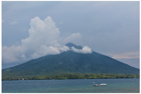
Ternate Island is a volcanic island with an area of 111 km2, located in the west of Halmahera Island in North Maluku Province, which was formed from the deposition of volcanic materials from the eruption of the Gamalama volcano [4]. Gradually, volcanic material in the form of lava or other large and heavy material settles around the crater; meanwhile, the lighter material is ejected or blown away by the wind. Due to gravity and the force of rainwater, some of the material at the top erodes and settles in the lower parts, thus forming the landscape of Ternate Island as it is today (Figure 1).
Figure 1. The landscape of Ternate Island
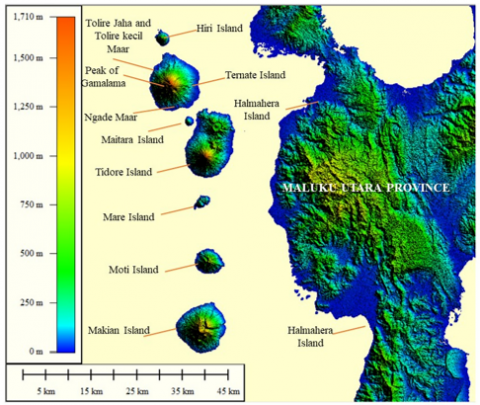
Ternate Island consists of a Gamalama volcano, shaped like a cone with a peak at an altitude of 1,715 meters above sea level. Gamalama is an active stratovolcano where the last eruption occurred in 2018. The eruptions generally happen in the central crater located at the peak. In historical records, the Gamalama volcano had experienced several parasitic eruptions, namely when the center of the eruption moved far to the side of the volcano and left traces in the form of maars. Three maars formed due to parasitic eruptions can still be found on Ternate Island: Maar Ngade, Maar Tolire Jaha, and Maar Tolire Kecil [5, 6].
The maar distribution and the active crater pattern of Gamalama volcano on Ternate Island show a straight line in the direction of N 15 E, which is parallel to a series of volcanic islands to the west of Halmahera Island, namely Tidore Island, Maitara Island, Ternate Island, and Hiri Island (Figure 2) [7]. In addition to the three parasitic eruption points, there is also a parasitic eruption point below sea level, which is located about 1 km to the southeast of Ngade Maar [5].
In Ternate Island, no rivers flow throughout the year but are generally intermittent, which in local terms are called barangka. Several large main barangka became the main flow of eruptive materials towards the sea. Some erupted lava flows from the past are still clearly visible and have been covered by other materials or vegetation in a few places. The famous lava flow is known as Batu Angus, located on the north and northeast sides of Ternate Island.
Figure 2. The maar alignment pattern on Ternate Island is parallel to a series of volcanic islands to the west of Halmahera Island
The southern and southeastern slopes are dominated by weathered material from Old Gamalama. On the western slopes were found material remains of Adult Gamalama Dewasa, while on the northern slopes were found materials from Young Gamalama. In the volcanic cone, several peaks mark the evolution of the Gamalama volcano. The peak of Old Gamalama can now be found at Melayu Hill or Mount Kekau, which extends from northeast to southwest. The remnants of the Adult Gamalama peak can now be found on Keramat Hill or Meidina Hill, which extends from west to east. Meanwhile, the peak of Young Gamalama as the location of the central crater hole is still active today, located in Arfat Peak.
Ternate is a small island with a high population that, from 1999-2010, served as the capital of North Maluku Province before being moved to Sofifi and is known to have an essential function as one of the centers of economic growth in Eastern Indonesia [8]. Ternate Island is divided into five districts: South Ternate, North Ternate, West Ternate, Central Ternate, and Ternate Island, while the number of villages on Ternate Island is 59 villages. In North Maluku Province, Ternate Island has become an important economic center and an entry point for air and sea transportation, as indicated by Sultan Baabullah International Airport and Ahmad Yani Port, which serve transportation to several regions in Indonesia. These developments show that disasters by the eruption of the Gamalama volcano that can happen at any time do not necessarily reduce the number of people who want to stay on Ternate Island. This is also supported by the fact that Ternate is the city with the highest population in North Maluku Province after South Halmahera, but it is still the most densely populated city because it has the smallest area in the whole province [9, 10].
Residents of Ternate Island who are afflicted by the threat of the catastrophic impact of the Gamalama volcanic eruption still prefer to stay by maintaining a conservative attitude in the face of a possible eruption disaster. It is relatively known that there has been no permanent evacuation of the population of Ternate Island on a large scale despite the threat of an eruption. The community only evacuated temporarily to another location on Ternate Island, which was considered safe, or to nearby islands, and then immediately returned to their respective homes after the eruption ended. This is because the residents of Ternate Island have felt at one with the nature of Ternate, which since the colonial era has been widely known as an island that is very rich in spices, especially cloves [8, 11].
With these conditions, knowledge of Ternate Island's volcanic activity is needed, but it's limited. Many people have forgotten about the eruption from decades ago. Hence, past volcanic activity must be revealed. From a technical point of view, knowledge of the history of volcanic activity in the past can be considered for planning eruption disaster mitigation activities in an area. While from a scientific point of view, historical records can be used for forecasting future eruptions. The limitations of historical records will make it more difficult to make forecasts [12].
In addition, research on the Gamalama volcano that has been carried out previously is in the form of case studies of the eruption that have occurred, the hazard and challenges of handling it [13, 14], the community's preparedness and knowledge of the volcanic hazard [4], the reveal of its magmatic system [15], the planning of transportation infrastructure to support disaster mitigation [16] and a few others. However, the significance of the relationship between the repose period and the magnitude of the eruption, known as the volcanic explosivity index (VEI) is still very rarely studied, especially at Gamalama volcano, which has a relatively complete historical record as a study guide to provide helpful information for disaster mitigation efforts.
Therefore, understanding the history of volcanic activity is fundamental to assessing the hazard of volcanoes in an area that has historically been known as an active volcano. Volcanic islands with active volcanoes have a high risk of causing disasters to the communities living around them. For this reason, it is necessary to study the history of eruptions and their impacts so that people can better prepare themselves if they face similar disasters in the future. This study aims to reveal the volcanic history of the Gamalama volcano on Ternate Island and to analyze the relationship between the repose period and the eruption magnitude. The results of this study are expected to increase knowledge about the relationship between repose period and eruption magnitude of Gamalama volcano to reduce the risk of disasters caused by its eruption.
Historical data on the eruption of the Gamalama volcano was collected from various reliable sources, such as 1.) Basic data of Indonesia volcanoes published by Center of Volcanology and Geological Hazard Mitigation (CVGHM), 2.) Data of volcanic activity monitoring report from the Gamalama Volcano Observation Office, 3.) The volcanoes of the world database compiled by the Smithsonian Institution for Global Volcanism Program, 4.) Several selected papers collect primary data on volcanic eruptions and their impacts [17, 18].
Data of the time of the eruption, VEI, and the impact of the eruption are inputted into the Microsoft Excel program worksheet. Determining the repose time of the eruption is done by calculating the difference between the eruption's year and the previous eruption's year. The results of the repose time analysis from 1510-2018 are presented in a repose time graph for each eruption year.
Furthermore, the repose time was analyzed using descriptive statistics to determine the average repose time of the eruption. Descriptive statistics summarize and describe factual and accurate data related to facts and the relationships between the phenomena studied so that their meaning can be simply captured and understood. Measures of central tendency such as the mean and measures of dispersion such as standard deviation are included as one of the presentations of the descriptive statistical analysis. Mean is the average calculated value of all observed values which can represent the entire data. However, the mean alone cannot capture the variability in a data set, so a standard deviation is needed, namely the average difference between the mean and the value of each observation, by describing the extent to which variable values are similar or vary [19, 20]. The relationship between the mean and the standard deviation is that the standard deviation value that is closer to zero means the data points are also closer to the mean value which indicates low data variability, meaning the mean value is more reliable [21].
In this analysis, eruption data were analyzed in three timescales to be able to see each pattern. The first timescale range is between 1510-1831, then between 1833-2018, and the last is the entire eruption year, which ranges between 1510-2018. Generally, the repose time is related to the accompanying eruption energy. A Spearman Rank correlation analysis was conducted using SPSS software to determine the relationship between the repose time and VEI. In addition, an analysis of the relationship between repose time and the eruption's impact on humans was also carried out.
3.1 The history of the eruption of the Gamalama volcano
Gamalama volcano is one of the most active volcanoes in Indonesia, and the first recorded eruption in history was in 1510 [22]. Until 2019, Gamalama erupted 77 times (Table 1), and 17 of them produced lava flows [23]. The products of the eruption of the Gamalama volcano varies, such as pyroclastics, molten lava, and various types of tephra ranging from ash, sand, and gravel, to bombs. Gamalama volcano's eruptive material deposits from time to time have resulted in the formation of the volcanic island of Ternate as it is today.
Ternate's name has long since soared in the spice trade world so that it has become a shipping destination for traders from Asia (China, Arabia, Gujarat), Europe (Portuguese, Spain, England, the Netherlands), and Indonesian traders, including those from Java, Malacca and Makassar [24-28]. Therefore, it is not surprising that records regarding Ternate, including Gamalama's volcanic activity, are well recorded in historical records since the early 16th century (Table 1). Generally, the eruptions of the Gamalama volcano occurred in the central crater [7, 23]. However, several eruptions happened in the form of parasitic eruptions, including in 1763 and 1775 (Table 1). To date, nine craters have been recorded, namely Madiena, Puncak Arfat, K1, K2, K3, K4, Tolire Jaha, Tolire Kecil, and Danau Laguna [6, 29]. If a line is drawn from these craters, a northwest-southeast-oriented structural pattern that cuts the peak of Gamalama parallel to the arc of the island of Halmahera will be formed [7].
Table 1. Historical records of the eruption of the Gamalama Volcano
|
Number |
Eruption year |
Repose period (years) |
VEI |
|
1 |
1510 |
|
3 |
|
2 |
1538 |
28 |
3 |
|
3 |
1551 |
13 |
|
|
4 |
1552 |
1 |
|
|
5 |
1561 |
9 |
2 |
|
6 |
1605 |
44 |
2 |
|
7 |
1608 |
3 |
3 |
|
8 |
1635 |
17 |
2 |
|
9 |
1643 |
8 |
2 |
|
10 |
1648 |
5 |
2 |
|
11 |
1653 |
5 |
3 |
|
12 |
1659 |
6 |
2 |
|
13 |
1676 |
17 |
2 |
|
14 |
1686 |
10 |
2 |
|
15 |
1687 |
1 |
3 |
|
16 |
1737 |
50 |
2 |
|
17 |
1739 |
2 |
2 |
|
18 |
1763 |
24 |
2 |
|
19 |
1770 |
7 |
3 |
|
20 |
1771-1772 |
1 |
3 |
|
21 |
1773-1774 |
1 |
2 |
|
22 |
1775 |
1 |
3 |
|
23 |
1811 |
36 |
2 |
|
24 |
1812 |
1 |
2 |
|
25 |
1814 |
2 |
2 |
|
26 |
1821 |
7 |
1 |
|
27 |
1831 |
10 |
2 |
|
28 |
1833 |
2 |
2 |
|
29 |
1835 |
2 |
2 |
|
30 |
1838 |
3 |
2 |
|
31 |
1839 |
1 |
2 |
|
32 |
1840 |
1 |
3 |
|
33 |
1841 |
1 |
1 |
|
34 |
1842 |
1 |
1 |
|
35 |
1843 |
1 |
2 |
|
36 |
1844 |
1 |
1 |
|
37 |
1845 |
1 |
1 |
|
38 |
1846 |
1 |
2 |
|
39 |
1847 |
1 |
2 |
|
40 |
1849-1850 |
2 |
2 |
|
41 |
1858-1859 |
8 |
1 |
|
42 |
1860 |
1 |
1 |
|
43 |
1862 |
2 |
2 |
|
44 |
1863 |
1 |
2 |
|
45 |
1864-1865 |
1 |
2 |
|
46 |
1868-1869 |
3 |
2 |
|
47 |
1871 |
2 |
2 |
|
48 |
1884 |
13 |
2 |
|
49 |
1895 |
9 |
1 |
|
50 |
1896 |
1 |
1 |
|
51 |
1897 |
1 |
1 |
|
52 |
1898 |
1 |
2 |
|
53 |
1900 |
2 |
1 |
|
54 |
1907 |
7 |
2 |
|
55 |
1911 |
4 |
1 |
|
56 |
1918 |
7 |
1 |
|
57 |
1923 |
5 |
2 |
|
58 |
1933 |
10 |
2 |
|
59 |
1938 |
5 |
2 |
|
60 |
1962-1963 |
24 |
2 |
|
61 |
1980 |
18 |
2 |
|
62 |
1983 |
3 |
3 |
|
63 |
1988 |
5 |
2 |
|
64 |
1990 |
2 |
3 |
|
65 |
1993 |
3 |
2 |
|
66 |
1994 |
1 |
2 |
|
67 |
1996 |
2 |
2 |
|
68 |
2003 |
9 |
2 |
|
69 |
2007 |
4 |
1 |
|
70 |
2008 |
1 |
1 |
|
71 |
2011 |
3 |
2 |
|
72 |
2012 |
1 |
1 |
|
73 |
2014 |
2 |
2 |
|
74 |
2015 |
1 |
2 |
|
75 |
2016 |
1 |
1 |
|
76 |
2018 |
2 |
1 |
Source: [14]
The repose period after the explosion varies widely, ranging from less than one year to 50 years. But generally, after a long repose period of more than ten years, the eruption is for certain large and has a significant impact especially for the people of Ternate, given the island’s small size and dense population. An example is an eruption that occurred after a 50-year repose period from 1687-1737, which produced a westward lava flow until it reached the sea [14]. Another example is the eruption after an 18-year repose period from 1962-1980, which had a massive explosion that formed a new crater, and its ash with a thickness of 10-15 cm entirely covered Ternate Island [30]. The social impact of the eruption in 1980 was the evacuation of around 40,000 people from Ternate Island to other surrounding islands such as Tidore Island, Hiri Island, and Halmahera Island [14, 30].
On the other hand, a short repose period does not necessarily mean that the eruption is small and doesn't have a significant impact. An example is an eruption that occurred after a 1-year repose period from 1770-1771, namely the eruption in 1771-1772, which produced lava flows and killed 40 people. Then, a side eruption with a 1-year repose period from 1774-1775 that happened in 1775 was no less phenomenal. This eruption produced a maar with a diameter of 700 meters at the top and a diameter of 350 meters at the bottom with a depth of between 40-50 meters. This eruption resulted in the loss of 141 people in the Soela Takome hamlet. The eruption in 1840 was also preceded by a 1-year repose period from 1839-1840, which then caused a tsunami on Halmahera Island [31, 32].
3.2 Eruption repose time and VEI
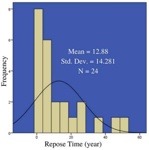
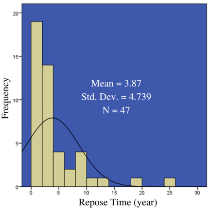
The average repose time of the eruption from 1510-1831 is 12.88 years and its standard deviation value is 14.281 (Figure 3), while the average repose time for the eruption from 1833-2018 is 3.87 years and its standard deviation value is 4.739 (Figure 4). Theoretically, it is known that a good data standard deviation is when the standard deviation value is smaller than the mean value [21]. Through the descriptive statistical analysis that has been carried out, the values of both standard deviations are slightly larger than the mean value. It can be concluded that the data for the average repose time of the eruption from 1510-1831 and 1833-2018 shows a high data variability. This means that the average repose time value of the eruption from 1510-1831 and 1833-2018 obtained are less reliable.
Figure 3. Histogram of the repose time of the 1510-1831 Gamalama volcano eruption
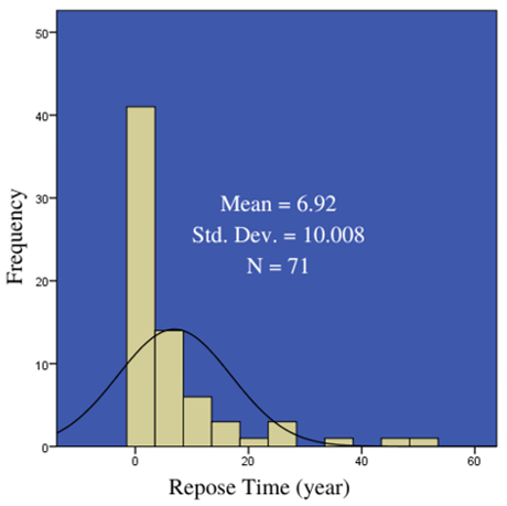
Overall, the average repose time of the Gamalama volcano eruption from 1510-2018 is 6.92 years and its standard deviation value is 10.008 (Figure 5). Like the previous analysis, the standard deviation value is larger than the mean value. This means the repose time data points from each year between 1510-2018 are quite spread out [21]. It can be concluded that the data for the overall average repose time of the eruption from 1510-2018 also shows a high data variability, meaning that the average value of the eruption from 1510-2018 obtained can’t be relied on. Through these results, it can be concluded that the average repose period is not always the same as the re-eruption period. If we refer to the repose time data for 1833-2018, it does not mean that an eruption occurs every three or four years. In fact, the eruption may occur with a repose period of less or even more than three years. This is in accordance with the characteristics of descriptive statistics, namely its results can’t be used to make any generalizations. To do so, an inferential statistical analysis must be carried out [33].
The variation in repose time is generally related to the eruption's energy level [34]. Short repose periods between eruptions are usually followed by low energy eruptions, whereas long repose periods are followed by high energy eruptions. One of the energy levels of the eruption can be expressed in VEI. Throughout the eruption history of the Gamalama volcano from 1510-2018, it has been recorded that the VEI of its eruption varies between the scale of 1-3 (Table 1).
Figure 4. Histogram of the repose time of the 1833-2018 Gamalama volcano eruption
Figure 5. Histogram of the repose time of the 1510-2018 Gamalama volcano eruption
To see the relationship between the variation of repose time and the magnitude of the eruption that followed, a correlation test was carried out between the repose time and the VEI. The results of the Spearman's Rank correlation analysis with SPSS software are presented in Table 2. It can be seen that the correlation coefficient between repose time and VEI obtained a value of 0.164. This value is in the correlation range between 0.00-0.199 which means it is very low. The significance value of the relationship is 0.173 which is greater than 0.05, meaning that there is no significant relationship between repose time and VEI at Gamalama volcano.
Table 2. Correlation results between repose time and VEI
|
|
Spearman’s rho |
||
|
Repose time (year) |
|||
|
Correlation coefficient |
Sig. (2-tailed) |
N |
|
|
Repose Time (year) |
1.000 |
. |
71 |
|
VEI |
.164 |
.173 |
71 |
Although the results of the correlation test concluded that there was no significant relationship between repose time and the VEI of Gamalama volcano, an interesting fact was found through the analysis of repose time on the impact of the eruption on humans, namely the existence of a pretty convincing relationship. A reasonably long repose period of 10-20 years is usually followed by eruptions that significantly impact human activities even with the VEI scale of 2, as in the case of eruptions in 1962, 1980, 2003, and 2011. In the case of Gamalama volcano eruptions, the VEI does not always correlate with the eruption's impact on humans because small VEI can still have a significant effect, as in the case of the 1980 and 2015 eruptions [4].
Through the data processing that has been carried out in this research, it can be known that the average repose period for the Gamalama volcano's eruption is not always the same as the re-eruption period. This means that eruptions can occur at any time with repose periods that are less or more than the known average. Through the statistical analysis of Spearman's Rank correlation, it was found that there was no significant relationship between repose time and VEI. However, from the analysis of the repose time on the eruption's impact on humans, an interesting fact was found about the relationship between the two: a relatively long repose period of 10-20 years is usually followed by an eruption that significantly impacts human activities because generally, longer rest periods tend to store a greater eruption energy, as shown in the eruption cases in 1962, 1980, 2003, and 2011 with a VEI scale of at least 2. The results from the historical data and its explaination will refresh the knowledge of the history of Gamalama volcano’s volcanic activity. Meanwhile, the results of this descriptive statistical research related to Gamalama volcano’s repose period and VEI related to the eruption’s impact to humans cannot be generalized yet, but it can encourage and initiate other researches to conduct an inferential statistical analysis with aims to obtain results that can be generalized to a wider population by assisting disaster mitigation efforts, especially volcanic eruptions.
The authors acknowledge the Institute for Research and Community Service of Universitas Sebelas Maret and RKAT PTNBH of Universitas Sebelas Maret for funding received for the Fundamental Research Scheme (254/UN27.22/PT.01.03/2022). The authors would like to show gratitude to the research assistants for field data collection. We also wish to thank Yeni Inka, Denny Caknan, and Abah Lala for their support and encouragement during the writing process. Finally, the authors would also like to thank anonymous reviewers for their comments and suggestions on this paper.
|
VEI |
Volcanic Explosivity Index |
|
CVGHM |
Center of Volcanology and Geological Hazard Mitigation |
[1] Yulaelawati, E., Syihab, U. (2008). Mencerdasi Bencana. PT Gramedia Widiasarana Indonesia, Jakarta, Indonesia.
[2] Habibi, P., Tanaya, I.G.L.P. (2019). Pembangunan Desa Rawan Bencana. Kementerian Desa, Pembangunan Daerah Tertinggal dan Transmigrasi Republik Indonesia, Jakarta, Indonesia.
[3] Prasongko, E.T. (2018). Gunung Berapi di Indonesia. Alprin, Semarang, Indonesia.
[4] Hidayat, A., Hadmoko, D.S., Marfai, M.A., Mutaqin, B.W. (2022). Volcanic hazard knowledge and preparedness of small island community on the flank of Gamalama volcano Ternate Island–Indonesia. GeoJournal. https://doi.org/10.1007/s10708-022-10682-9
[5] Verstappen, H.T. (1983). Applied Geomorphology: Geomorphological Surveys for Environmental Development. Elsevier, Amsterdam, Netherlands.
[6] Bronto, S., Hadisantono, R.D., Lockwood, J.P. (1982). Peta Geologi Gunungapi Gamalama, Ternate, Maluku Utara. Direktorat Vulkanologi, Bandung, Indonesia.
[7] Pratomo, I., Sulaeman, C., Kriswati, E., Suparman, Y. (2011). Gunung Gamalama, Ternate, Maluku Utara: Dinamika Erupsi dan Potensi Ancaman Bahayanya, in Maryanto, I., Sutrisno, H. (Ed.), Ekologi Ternate. LIPI Press, Jakarta, Indonesia.
[8] Dalidjo, N. (2020). Rumah di Tanah Rempah: Penjelajahan Memaknai Rasa dan Aroma Indonesia. PT Gramedia Pustaka Utama, Jakarta, Indonesia.
[9] Central Bureau of Statistics of North Maluku Province. (2021). Potret Sensus Penduduk 2020 Provinsi Maluku Utara. Badan Pusat Statistik Provinsi Maluku Utara, Ternate, Indonesia. pp. 16-18. https://malut.bps.go.id/publication/2021/05/26/718566b2fcd5ed4dc8b4beba/potret-sensus-penduduk-2020-provinsi-maluku-utara.html.
[10] Central Bureau of Statistics of North Maluku Province. (2022). Kepadatan Penduduk Menurut Kabupaten/Kota 2019-2021. Badan Pusat Statistik Provinsi Maluku Utara, Ternate, Indonesia. https://malut.bps.go.id/indicator/12/55/1/proyeksi-penduduk-menurut-kabupaten-kota.html.
[11] Haris, S. (2014). Partai, Pemilu, dan Parlemen: Era Reformasi. Yayasan Pustaka Obor Indonesia, Jakarta, Indonesia.
[12] Sparks, R.S.J., Aspinall, W.P. (2004). Volcanic Activity: Frontiers and Challenges in Forecasting, Prediction and Risk Assessment. American Geophysical Union, Washington, D.C., United States of America, pp. 359-373. http://dx.doi.org/10.1029/150GM28
[13] Hidayat, A., Marfai, M.A., Hadmoko, D.S. (2020). Eruption hazard and challenges of volcanic crisis management on a small island: A case study on Ternate Island – Indonesia. International Journal of GEOMATE, 18(66): 171-178. https://doi.org/10.21660/2020.66.ICGeo43
[14] Hidayat, A., Marfai, M.A., Hadmoko, D.S. (2020). The 2015 eruption of Gamalama volcano (Ternate Island – Indonesia): Precursor, crisis management, and community response. GeoJournal, 87: 1-20. https://doi.org/10.1007/s10708-020-10237-w
[15] Kunrat, S., Bani, P., Haerani, N., Saing, U.B., Aiuppa, A., Syahbana, D.K. (2020). First gas and thermal measurements at the frequently erupting Gamalama volcano (Indonesia) reveal a hydrothermally dominated magmatic system. Journal of Volcanology and Geothermal Research, 407(1): 107096. https://doi.org/10.1016/j.jvolgeores.2020.107096
[16] Raharjo, E.P., Sarjana, S., Safitri, M. (2022). Transportation infrastructure planning in supporting disaster mitigation: Case study in Mount Gamalama. Journal of Disaster Risk Studies, 14(1): 1123. https://doi.org/10.4102%2Fjamba.v14i1.1123
[17] Witham, C.S. (2005). Volcanic disasters and incidents: A new database. Journal of Volcanology and Geothermal Research, 148(3-4): 191-233. https://doi.org/10.1016/j.jvolgeores.2005.04.017
[18] Brown, S.K., Jenkins, S.F., Sparks, R.S.J., Odbert, H., Auker, M.R. (2017). Volcanic fatalities database: Analysis of volcanic threat with distance and victim classification. Journal of Applied Volcanology, 6(15). https://doi.org/10.1186/s13617-017-0067-4
[19] Kaur, P., Stoltzfus, J., Yellapu, V. (2018). Descriptive statistics. International Journal of Academic Medicine, 4(1): 60-63. https://doi.org/10.4103/IJAM.IJAM_7_18
[20] Prihatiningsih, D. (2022). Mudahnya Belajar Statistik Deskriptif. CV Sarnu Untung, Purwodadi, Indonesia.
[21] Lubis, Z., Manaf, A.H.A., Ahmad, Hj.M.A.Hj., Abdullah, M.S., Junoh, M.Z.M. (2019). Panduan Pelaksanaan Penelitian Sosial. ANDI, Yogyakarta, Indonesia.
[22] Global Volcanism Program. (2013). Gamalama (268060) in Volcanoes of the World, v. 4.8.0. Venzke, E (Ed.). Smithsonian Institution.
[23] Bacharudin, R., Martono, A., Djuhara, A. (1996). Peta kawasan rawan bencana Gunungapi Gamalama, Ternate, Maluku Utara. Direktorat Vulkanologi, Bandung, Indonesia.
[24] Taylor, P.M. (1999). Introduction to F.S.A. De Clercq's (Ternate: The Residency and its Sultanate) in De Clercq, F.S.A., 1890. Ternate: The Residency and Its Sulatnate. Translated from the Dutch by Taylor, P.M. and Richards, M.N. in 1999. Smithsonian Institution Libraries, Washington, D.C., United States of America.
[25] Ammari, F., Siokona, J.W. (2003). Ternate: Kelahiran dan Sejarah Sebuah Kota. Pemerintah Kota Ternate, Ternate, Indonesia.
[26] Amal, M.A. (2009). Portugis dan Spanyol di Maluku. Komunitas Bambu, Jakarta, Indonesia.
[27] Daud, M.S. (2012). Ternate: Heritage City Mosaic. Lembaga Kebudayaan Rakyat Moloku Kie Raha, Ternate, Indonesia.
[28] Kantor Arsip dan Perpustakaan Daerah Kota Ternate. (2015). Citra Ternate dalam Arsip dan Visualisasi 2015. Kantor Arsip dan Perpustakaan Daerah Kota Ternate, Ternate, Indonesia.
[29] Setiawan, F., Wibowo, H., Santoso, A.B., Nomosatryo, S., Yuniarti, I. (2014). Karakteristik danau asal vulkanik; Studi kasus Danau Tolire, Pulau Ternate. Limnotek, 21(2): 103-114. http://dx.doi.org/10.14203/limnotek.v21i2.3
[30] Hidayat, A., Marfai, M.A., Hadmoko, D.S. (2020). Eruption on Indonesia’s volcanic islands: a review of potential hazards, fatalities, and management. IOP Conference Series: Earth and Environmental Science, 485(012061): 1-11. https://doi.org/10.1088/1755-1315/485/1/012061
[31] Paris, R., Switzer, A.D., Belousova, M., Belousov, A., Ontowirjo, B., Whelley, P.L., Ulvrova, M. (2014). Volcanic tsunami: A review of source mechanisms, past events, and hazards in Southeast Asia (Indonesia, Philippines, Papua New Guinea). Natural Hazards, 70(1): 447-470. https://doi.org/10.1007/s11069-013-0822-8
[32] De Clercq, F.S.A. (1890). Ternate: The Residency and Its Sultanate. Smithsonian Institution Libraries, Washington, D.C., United States of America.
[33] Nestor, P.G., Schutt, R.K. (2015). Research Methods in Psychology: Investing Human Behavior, Second Edition. SAGE Publications, California, United States of America.
[34] Kiswiranti, D., Brotopuspito, K.S. (2013). Analisis Statistik Temporal Erupsi Gunung Merapi. Jurnal Fisika, 3(1): 37-42. https://doi.org/10.15294/jf.v3i1.3964