Nawfal H. Almousawi* | Wahda S.H. Al-Hinkawi | Abd Al-Hussein A. Al-Askary
© 2022 IIETA. This article is published by IIETA and is licensed under the CC BY 4.0 license (http://creativecommons.org/licenses/by/4.0/).
OPEN ACCESS
Previous urban studies, which started from the twentieth century until now, have unanimously agreed to displace the human dimensions of the traditional city and replace them with inhuman dimensions in the modern city. Consequently, there were various calls for returning human dimensions to urban space via urban design theories. This research concentrated on the human temporal awareness as one of the dimensions that distinguish the human race and the connection of the connection between this dimension with urban place. The lack of urban principles resulting from human temporal awareness has created the knowledge gap. In addition, the objective of this research was to build an urban model with spatial indicators. In order to achieve this objective, a comprehensive theoretical framework was built by adopting a descriptive- analytical approach. The novelty of the research is to find an urban model with spatial indicators that works to enhance human temporal awareness and verify this model and give it a local character by applying it to urban space in Baghdad. The research faced significant limitations represented in the theoretical framework and the practical application of the research model. As for future research, the research recommends conducting studies to find a model with spatial indicators for the humanization of urban space, including all human dimensions.
humanization, urban place, temporal awareness, Al-Mutanabbi St.
From the middle of the twentieth century, many urban design theorists have emphasized the importance of adopting human beings as a reference point in urban design. In 1952, Jaqueline Tyrwhitt, Ernesto Rogers, and Josep Llius Sert wrote an essay entitled Centers of Community Life, as an introduction to The Heart of the City: Towards The Humanization of Urban Life [1]. Kevin Lynch defined design as the imaginative creation of form that aims to achieve some human purpose, social, economic, aesthetic or technical [2]. Calls for the humanization of urban spaces continued, even at the turn of the millennium, when the process of humanization was linked to urban development strategies and considered the biggest challenge in building an inclusive city [3]. The main goal of urban design became centered on creating more humanistic environments [4], so humanity must be the primary concern of urban design [5].
There have been various movements in response to the calls for the humanization of urban spaces. However, these movements clashed with the problem of defining the human being and the essential character that characterize him/her, which are reflected as spatial indicators in the urban environment. Defining the nature of man is a controversial issue. In this context, Robert B. Louden refers to Immanuel Kant's question about how to transform a human with biological dimensions into a human in the total sense. Louden answers this question through the features of freedom and conscious rational control over instincts, desires, and dignity [6]. At the same time, René Descartes points out that language is one of the essential features as well as mental causation, morals, and awareness of death [7]. The qualities that characterize the human race are language, intentions, desire, freedom, awareness, and the ability to laugh and learn [8]. Man is a unique being because of his language, insight, ability to use his mind and intelligence, and cultural and moral aspects [9].
In general, the foundation on which the human city is based stems from the dimensions that characterize the human race, where the human urban dimensions generate human urban principles, which in turn are reflected in the urban space in the form of spatial indicators that will be described in the research model. Given the limits of the research, it will be limited to addressing the temporal awareness dimension as one of the main dimensions achieved for humanity, as well as linking this awareness to the process of designing public urban places through the urban design process.
Acoording to above, the knowledge gap in the research will be; the absence of human spatial indicators results from human awareness of time.
The research will adopt a descriptive-analytical methodology, and the objective of the research will be achieved by building a model of urban place that enables people to be aware of time through the following steps, as shown in Figure 1:
The review of the previous urban literature that deals with the topic of time will be conducted and analyzed based on searching for urban principles and spatial indicators that constitute the urban space with a time dimension to arrive at the research model which will be verified when applied to urban space in Baghdad.
Figure 1. Method and steps used in the research
The main objective of the previous literature review is to explore urban principles and spatial indicators that enable humans to be aware of time.
3.1 Human awareness
Awareness is a characteristic that distinguishes the human race from the living beings, where awareness means that humans have a sensitive and conscious existential attitude [10]. Immanuel Kant believes humans are free and possess self-awareness and rationality [8]. Human awareness is a distinctive feature of man and a fundamental pillar of man’s freedom [11]. For Friedrich Nietzsche, human consciousness gives meaning to humanity as we can see things from an analytical perspective [12]. The human being needs awareness to evaluate his/her actions and think about what we have done, whether the person feels positive or negative about these attitudes and actions. Therefore, awareness is a prerequisite for considering man as a moral being [11].
Immanuel Kant argues that space and time are a priori things that build humanity empirically and that we cannot think of the world as something other than a spatiotemporal thing [13]. In essence, Friedrich Nietzsche asserts that human life is represented by the force that opens the past and the future, therefore representing human essence [14]. Martin Heidegger claimed that human life is a continuous series of time and space looking back and looking forward simultaneously, and we cannot ignore the historical dimension of man [15]. The drumbeat of the future cannot be one-way, but we must work according to the Janus-Faced Strategy; i.e., a person has an eye on tomorrow and an eye on yesterday, as shown in Figure 2 [15]. Maurice Merleau-Ponty also supports Heidegger's view of man's ability to project himself into the future [16], meaning that we are the only species that has an emerging ability to predict the future to anticipate the paths of events that have not yet occurred to complete preparing future proposals and alternatives [10].
Source: [17]
Figure 2. Janus face
3.2 Temporal awareness in urban place
Temporal awareness and the ability to relate the past to the present to predict the future is an essential factor in the success of urban places, and this has been pointed out by many urban theorists such as Kevin Lynch [18], John Montgomery [19], Matthew Carmona et al. [20], and by the UK Ministry of Housing [21]. The temporal awareness is one of the most important dimensions that distinguish human being from the rest of creation. Man has an existential position and is aware of his time, which enables him to see things from an analytical perspective to bring the past into the present to extrapolate the future, where awareness of time requires a space with spatial indicators that enable man to this process. The essential urban principles that have been linked to human temporal awareness are:
3.2.1 Urban environmental sustainability
Sustainable urban development is a state of temporal awareness of the urban future. This concept was confirmed by Portland Report 1983 [22], UNESCO [23], UK Department for Communities and Local Government [24], Jan Gehl [25], Omar Dominguez and Hazel Borys [26], and Joel Kotkin [27].
According to Llewelyn Davies [28], Urban Design London [29], and the UK Ministry of Housing [21], good places are those that possess the character of preserving natural resources and putting them in a state of balance with achieving human comfort. Therefore, sustainable places follow an energy hierarchy based on reducing the need for energy use, using energy-efficient systems, and maximizing renewable energy [21]. The use of green infrastructure should be encouraged [30]. Sustainable drainage systems should simulate natural drainage processes and remove pollutants from urban runoff [24]. The materials used can affect urban sustainability [29], where they are recommended to meet requirements such as maintenance, safety, durability, and sustainability in terms of manufacture and use [24]. We should choose the materials used based on the number of non-renewable resources that are consumed in manufacturing, transportation and construction, the ease of recycling materials, the amount of toxins and glare emitted from the materials, the quality of the materials’ insulation, the period of their resistance to weather conditions, the ease of repair or replacement and cleaning, and their suitability to their natural and artificial surroundings [31]. In addition, the greening of cities is a crucial factor in sustainability [20]. Trees, shrubs, grounds, and seasonal flowers can also be used to enhance temporal excellence in urban environments [28]. Enhancing the means of transportation can also contribute significantly to the sustainability of the city [32], as giving priority to pedestrian and bicycle movement in the movement of transport will be an essential element in urban sustainability policies and this is what many have pointed out, for instance Jan Gehl [25] and the Ministry of Housing and the UK Department of Housing [33]. A walkable, compact neighborhood with a mix of uses and amenities reduces energy demand and supports health and wellbeing [21].
3.2.2 Urban maintenance works
One of the controlling factors in urban design is the future management of the place [20]. Pleasant public places must be well-maintained and kept clean now and in the future [34]; therefore, urban maintenance is an essential factor in the success of places in the present and future [21]. Urban place management requires regular maintenance by providing quick repairs and cleaning as well as tending plants and removing weeds [35]. Also, farming must be designed for minimal maintenance [24]. Ben Rogers argues that he prefers to design streets and squares so that they can take care of themselves and do not need extensive monitoring or maintenance [36].
3.2.3 Urban time continuity
Many theorists point to the importance of linking the three times (past, present, and future) in urban places. This linkage was emphasized by urban design for the City of London [31]. But if urban transformation is inevitable in the city, it must be gradually [18]. An essential element of the temporal dimension of urban design is the need for designers to understand what should remain and what needs to change, so Michael Conzen 1960 emphasized the relative stability of streets and plots at the expense of buildings, yet many buildings have survived for hundreds of years. As the effectiveness and strength of its external appearance changed over the years [20]. It is essential to focus on how to repair and reuse previously developed or damaged parts of a site while preserving and respecting the undamaged parts [28].
All urban places are exposed to inevitable changes with the progression of time, where the most successful urban places are those that respond to these changes without bringing about radical transformations within them. That was confirmed by John Montgomery [19], Ken Worpole and Liz Greenhalgh [37], Tony Lloyd-Jones [38], Henry Shaftoe [34], Urban Design London [31], and Project for Public Spaces [39]. Flexible developments rely on small businesses more than mega businesses [40]. Urban places are flexible when they are: open and not divided into single-use subsections, can be divided or used as ample space for a variety of uses or events, there is diversity, they are not dominated by one means of transportation, or are only linked to infrastructure requirements or events related to a specific time, are comfortable, and finally are sociable, meaning that the urban place supports different types and patterns of social activities [20].
Table 1. The urban model of human temporal awareness
|
Urban dimension |
Urban principles |
Spatial indicator code |
Spatial indicators |
Spatial indicators’ details |
Indicator measuring method |
|
Temporal awareness |
Activating Environmental Sustainability Mechanisms (TS) |
TS-1 |
Use of green infrastructure systems |
Saving energy, reducing carbon emissions, and using alternative energy. |
Field survey |
|
TS-2 |
Use of environmentally friendly building materials |
Using sustainable materials with low emissions of glare, toxins and, heat insulation. |
Field survey |
||
|
TS-3 |
Preserving biodiversity |
The presence of different types of local plants and animals. |
Field survey |
||
|
TS-4 |
Encouraging pedestrian movement |
Provides pedestrian movement at different times of the day. |
Field survey |
||
|
TS-5 |
Working on a human scale |
The width of the street is in harmony with the height of the buildings, and an acceptable walking distance must not exceed 1 km. |
Field survey |
||
|
Carrying out maintenance works (TM) |
TM-6 |
Use of easy-to-maintain materials |
Using solid materials that do not require maintenance, have a long life, are easy to clean, do not become dirty quickly, and are suitable for local weather. |
Field survey |
|
|
TM-7 |
Conducting urban maintenance |
Providing human cadres to monitor and maintain electrical and health systems, civil works and landscaping, gardening, and general cleaning. |
Field survey |
||
|
Maintaining Time Continuity (TT) |
TT-8 |
Gradual urban transformation |
Gradual implementation of urban transformation works with the relative stability of streets, then plots of land, and finally non-heritage buildings, as well as accommodating shifts in use. |
Field survey |
|
|
TT-9 |
The buildings differ in terms of age |
The buildings vary from heritage to historical to modern and contemporary. |
Field survey |
||
|
TT-10 |
Consolidation of heritage assets |
Preservation of historical buildings. |
Field survey |
Table 2. Likert scale
|
Very negative |
Negative |
Neutral |
Positive |
Very positive |
|
1-1.8 |
1.81-2.6 |
2.61-3.4 |
3.41-4.2 |
4.21-5 |
Achieving awareness of time requires defining spatial indicators for this urban human dimension, so previous literature will be relied on to determine those indicators and specify their details to increase the measurement's objectivity, as shown in Table 1. The following points will, therefore, be taken into account when conducting the measurement of temporal dimensions:
The spatial indicators of human temporal awareness will be applied to urban place in Baghdad to verify those indicators and give the research model a local character, bearing in mind that there will be a possibility to exclude some of the indicators because they are not present in the study area. Several criteria were adopted in the selection process for the study area, which are:
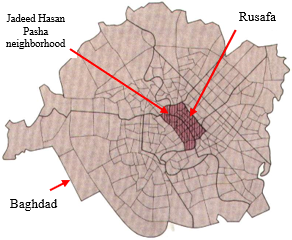
Al-Mutanabbi Street was chosen in accordance with the criteria; it is located in the old Rusafa district within the city of Baghdad, which directly overlooks the eastern side of the Tigris River in the center of Baghdad, as shown in Figure 3. Al-Mutanabbi Street is located in Jadeed Hasan Pasha neighbourhood in the old Rusafa area. The history of this neighborhood goes back to the days of the Abbasids; it was known as Darb Munira, and then it was called Jadeed Hasan Pasha neighborhood according to the governor of Baghdad, Hasan Pasha 1704-1723 [44]. This neighborhood has become an important political and social center for Baghdad, and this Importance continued during the emergence of the Iraqi Republic when it was the seat of the government and most of the ministries [45].
Source: [46].
Figure 3. The relation between Baghdad, Rusafa, and Jadeed hasan pasha neibourhood
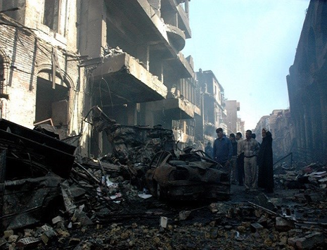
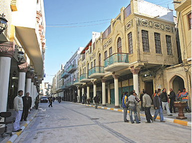
The street was then named Ekmegkhana Street at the end of the Ottoman era, which means bakery or kitchen street in the Turkish language. It was called by this name because there was an old building belonging to the army in which people cooked food and bread and prepared these to equip the army [47]. After the end of World War I 1914-1918, the book trade appeared in Iraq, especially after the establishment of the Iraqi State in 1921 [48]. The street was later named Al-Mutanabbi Street in 1932 by a committee in the Capital Municipality during the reign of King Faisal I in honor of the poet Abu Al-Tayyib Al-Mutanabbi [49]. As for the contemporary period, Al-Mutanabbi Street was subjected to a bloody terrorist explosion on 5 Mars 2007, which led to severe damage in the street, killing and wounding many citizens, as shown in Figure 4 [50]. Following this explosion, there was a rehabilitation campaign for the street in 2008 when the buildings were restored and clad with bricks, the river facade and infrastructure were rehabilitated, erection of a gate to the street, the cladding of the street with stone, and the construction of a mooring for boats [51], as shown in Figure 5.
Source: [50]
Figure 4. The terrorist explosion of Al-Mutanabbi Street 2007
Source: [52]
Figure 5. Rehabilitation of Al-Mutanabbi Street 2008
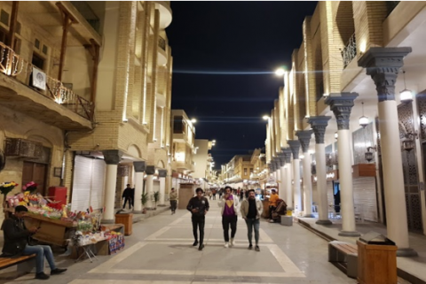
Currently, the street has witnessed a significant development campaign, which was opened with its new look on 12 December 2021. Al-Mutanabbi Street has become a cultural entertainment place that includes many activities of artistic and cultural works and various festivals. It is visited by Iraqis of different age groups and economic levels. This development campaign has dramatically affected its working hours, which extended from seven in the morning until after midnight, as shown in Figure 6.
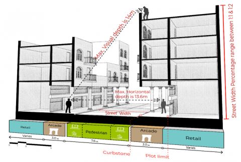
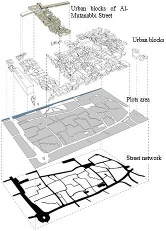
Al Mutanabbi Street is located in an area of a dense organic urban fabric with winding pedestrian-only streets flanked by a series of slow-speed motorways that include public transportation and parking. The site surrounding the street contains landmarks of high heritage value, such as cultural forums, museums, and historical buildings. The street's primary function is represented by selling books. The street has two main entrances from the northeast and south-west, as well as four secondary entrances from the south-east. The urban blocks that make up the site and Al-Mutanabbi Street do not exceed four floors (14-12) meters. The length of Al-Mutanabbi street from Al-Rasheed Street to the river is 310 m, and the area around it, represented by Jadeed Hasan Pasha neighborhood, which is located between the river and Al-Rasheed Street on one side, and on the other side is located between Al-Shuhada Bridge Street and Al-Midan Square as showen in Figure 7.
Figure 6. Al-Mutanabbi Street at present
Figure 7. Al-Mutanabbi street site
Studying public life in Al-Mutanabbi Street was undertaken through a field survey, photography, and analysis with specialized programs and work on 3D modeling Al-Mutanabbi Street. The temporal limits of the application of the research model was on Al-Mutanabbi Street between 15 January 2022 and 15 April 2022, from seven o’clock in the morning until midnight and on all days of the week. The results of the application of the research model can be summarized as follows:
A: The spatial indicators of the principle of activating environmental sustainability mechanisms (TS) scored 14/25 points with a rate of 56% through:
B: The spatial indicators of the principle to carry out maintenance work (TM) scored 8/10 points with a rate of 80% through:
C: The spatial indicators of the principle of maintaining the continuity of time (TT) scored 10/15 points with a rate of 67% through:
Figure 8. Section in Al-Mutaabbi street
Figure 9. The stability of streets, plots, and urban blocks in Jadeed Hasan Pasha neighborhood
Table 3. Fulfillment rate of temporal awareness dimension of Al-Mutanabbi Street
|
Urban dimension fulfillment rate |
Urban principles fulfillment rate |
Spatial indicators |
Spatial indicator score |
|
Temporal awareness 68% |
Activating Environmental Sustainability Mechanisms (TS) 14/25 = 56% |
Use of green infrastructure systems |
Very negative= 1 |
|
Use of environmentally friendly building materials |
Neutral= 3 |
||
|
Preserving biodiversity |
Very negative= 1 |
||
|
Encouraging pedestrian movement |
Positive 4 |
||
|
Working on a human scale |
Very positive= 5 |
||
|
Perform maintenance works (TM) 8/10 = 80% |
Use easy-to-maintain materials |
Positive= 4 |
|
|
Conducting urban maintenance |
Positive= 4 |
||
|
Maintaining Time Continuity (TT) 10/15 = 67% |
Gradual urban transformation |
Negative= 2 |
|
|
Buildings differ in terms of age |
Positive= 4 |
||
|
Consolidation of heritage assets |
Positive= 4 |
The subject of the human city is one of the vital topics of urban design at present, where the urban dimensions of this city are derived based on the dimensions that constitute the human essence. The dimension of temporal awareness in urban space represents one of the essential dimensions of human urban space and must be reinforced in public spaces through urban design processes. On this basis, the creation of this article is part of the process of humanizing urban space when the research reached a model with spatial indicators that contribute to building an urban space that enables people to perceive their time. The basic idea in creating this model depends on the link between human awareness of his time and the urban principles that achieve this distinction of humanity. The urban principles are urban sustainability and maintenance resulting from human awareness of the future, as well as the principle of preserving the continuity of urban time resulting from human awareness of that time starting from history and its ability to link it present to extrapolate the future as these urban principles are reflected in the form of urban spatial indicators in public spaces.
The strength of research in urban design appears when this research contributes to the presentation of a theoretical model that can be reflected in public urban spaces. That is when converting the theoretical framework based on philosophical foundations into material spatial indicators, which was evident in the practical application of the research model when applied to a traditional urban space based on human dimensions. This practical application has enabled researchers to verify the research model in addition to giving it a local character to solve the research problem and give the necessary recommendations to enhance the state of human awareness in time in a particular place.
The findings of this research have to be seen in the light of two significant limitations. The first limitation emerged from the theoretical framework, where the research collided with the diversity of views on the human city due to the multiplicity of points of view on the topic of defining the human being. In addition, there was a lack of research on temporal awareness in urban spaces, especially local research, which led to the adoption of the research methodology that was based on a review of previous literature to extrapolate spatial indicators. The second limitation is represented in the process of the practical application of the research model, where the limitations began through the difficulty of obtaining specialized historical studies on Al-Mutanabbi Street, which forced the researcher to extrapolate information about the street from indirect sources, as well as the problem of obtaining street information at present because it is a traditional area of organic nature. Consequently, these obstacles prolonged the period of the field survey. The research also faced limitations during the practical application of the research model represented by the measurement tools for each spatial indicator, where the researcher relied on direct observation from a relatively personal point of view to reach the results of the practical study. The last obstacle in the field study is the difficulty of finding a weight for each principle and spatial indicator that enhances awareness of the urban space. The researcher assumed they have equal importance and adopted the Likert pentagonal scale to verify the research model.
The research model has been verified when the research indicators was applied to a traditional area with human features, where Al-Mutanabbi Street area achieved a good temporal awareness, despite the difficulty of applying urban sustainability mechanisms to the traditional region and the difficulty of transforming its traditional morphology over time.
In general, the research recommends the authorities responsible for managing public places in Baghdad to create urban spaces according to the human dimensions. In particular, the researchers suggest adopting the research model (urban principles and spatial indicators) to enhance the state of awareness of time in public places. As for the recommendations related to Al-Mutanabbi Street, it was represented in strengthening the spatial indicators of environmental sustainability in a way that does not diminish the historical value of the street. This strengthening will occur through modern green infrastructure systems. The researchers also recommend introducing the Zeitgeist to the street through the use of modern technology in some buildings, events, or cultural works based on virtual reality technology. The researchers recommend studies on defining all urban human dimensions while determining the weights of urban principles and spatial indicators to create a public space humanity index to evaluate these pubic places objectively. In addition, it is preferable to conduct a specialized historical study on Al-Mutanabi Street and conduct a field survey to establish the reality of the street’s condition, given the cultural, historical, and social values that the street represents.
[1] Marshall, R. (2009). The elusiveness of urban design: the perpetual problem of definition and role. In: Krieger, A., Saunders, W. (eds) Urban Design. University of Minnesota Press, Minneapolis. https://www.upress.umn.edu/book-division/books/urban-design.
[2] Madanipour, A. (2007). Ambiguities of Urban Design. In: Carmona, M., Tiesdell, S. (eds) Urban Design Reader. Architectural Press, Oxford. https://www.routledge.com/Urban-Design-Reader/Tiesdell-Carmona/p/book/9780750665315.
[3] Girard, L.F. (2016). Towards Sustainable Planning: Agenda 21, Habitat. In: Alexander, E. R. (ed) Evaluation in Planning: Evolution And Prospects. Routledge, London. https://www.routledge.com/Evaluation-in-Planning-Evolution-and-Prospects/Alexander/p/book/9781138250123.
[4] Krieger, A. (2013). Where and How Does Urban Design Happen? In: Larice, M., Macdonald, E. (eds), the Urban Design Reader. Routledge, New York. https://doi.org/10.4324/9780203094235
[5] Maki, F. (2009). Fragmentation and Friction as Urban Threats: The Post- 1956 City. In: Krieger, A., Saunders, W. (eds) Urban Design. University of Minnesota Press, Minneapolis. https://www.upress.umn.edu/book-division/books/urban-design.
[6] Louden, R.B. (2011). Kant’s Human Being: Essays on his Theory of Human Nature. Oxford University Press, New York, 138. http://dx.doi.org/10.1093/acprof:osobl/9780199768714.001.0001
[7] Machery, E. (2008). A plea for human nature. Philosophical Psychology, 21(3): 321-329. http://dx.doi.org/10.1080/09515080802170119
[8] Scruton, R. (2017). On Human Nature. Princeton University Press, New Jersey, 17-44. http://dx.doi.org/10.2307/j.ctvc77b9d
[9] Suddendorf, T. (2014). What makes us human? https://www.psychologytoday.com/us/blog/uniquely-human/201403/what-makes-us-human, accessed on Jun. 22, 2019.
[10] Smith, C. (2010). What Is a Person? The University of Chicago Press, London. http://dx.doi.org/10.7208/chicago/9780226765938.001.0001
[11] Norman, R. (2004). On Humanism: Thinking In Action. London, Routledge, 59-61. http://dx.doi.org/10.4324/9780203219911
[12] Navilon, G. What does it mean to be human. https://ideapod.com/what-does-it-mean-to-be-human-famous-philosophers-answer/, accessed on Jul. 18, 2020.
[13] Frierson, P.R. (2013). What is the Human Being? Routledge, New York, 16. http://dx.doi.org/10.4324/9780203070314
[14] Michalski, K. (1998). Human Nature and the Nature of Time: A Nietzschean Metaphor and Its Consequences. In: Cohen, R. S., Tauber, A. I. (eds) Philosophies of Nature: The Human Dimension. Springer Dordrecht, Berlin. https://doi.org/10.1007/978-94-017-2614-6
[15] Classen, A. (2015). The Challenges of the Humanities, Past, Present, and Future: Why the Middle Ages Mean So Much for Us Today and Tomorrow. In: Classen, A. (ed) The Challenges of the Humanities, Past, Present, and Future. MDPI, Basil. https://doi.org/10.3390/books978-3-03842-055-2
[16] Oliver, K. (2009). Animal Lessons: How They Teach Us to Be Human. Columbia University Press, New York, 210. http://cup.columbia.edu/book/animal-lessons/9780231147262.
[17] Bidoonism, A. Janus-faced. https://bidoonism.com/2019/11/13/janus-faced/, accessed on Apr. 23, 2022.
[18] Lynch, K. (1972). What Time is this Place? The MIT Press Cambridge, Massachusetts, 3, 240. https://mitpress.mit.edu/9780262620321/.
[19] Montgomery, J. (1998). Making a city: Urbanity, vitality and urban design. Journal of Urban Design, 3(1): 93-116. http://dx.doi.org/10.1080/13574809808724418
[20] Carmona, M., Heath, T., Oc, T., Tiesdell, S. (2003). Public Places- urban Spaces: The Dimesions of Urban Design. Architectural Press, Oxford, 193, 284, 195, 202. https://www.amazon.com/Public-Places-Spaces-Matthew-Carmona/dp/0750636327.
[21] Ministry of Housing, Communities and Local Government. (2021). National Design Guide: Planning Practice Guidance for Beautiful, Enduring and Successful Places. Crown. https://assets.publishing.service.gov.uk/government/uploads/system/uploads/attachment_data/file/962113/National_design_guide.pdf.
[22] Moughtin, C. (2003). Urban Design: Street and Square. Routledge, London, 192. http://dx.doi.org/10.4324/9780080520278
[23] UNESCO. (1996). Humanizing the City. UNESCO, Istanbul, 10. https://unesdoc.unesco.org/ark:/48223/pf0000103738?posInSet=1&queryId=N-EXPLORE-47f79ec1-1e5c-48c7-a362-6e028973dad6.
[24] Department for Communities and Local Government. (2007). Manual for Streets. Thomas Telford Ltd, London, England. https://assets.publishing.service.gov.uk/government/uploads/system/uploads/attachment_data/file/1072722/Essex_Manual_for_Streets_Redacted.pdf.
[25] Gehl, J. (2010). Cities for People. Island Press, Washington, 109, 105, 26. https://islandpress.org/books/cities-people.
[26] Hanss, D., Böhm, G. (2012). Sustainability seen from the perspective of consumers. International Journal of Consumer Studies, 36(6): 678-687. https://doi.org/10.1111/j.1470-6431.2011.01045.x
[27] Seghezzo, L. (2009). The five dimensions of sustainability. Environmental Politics, 18(4): 539-556. https://doi.org/10.1080/09644010903063669
[28] Davies, L. (2007). Urban Design Compendium. English Partnerships & The Housing Corporation. https://webapps.stoke.gov.uk/uploadedfiles/Urban%20Design%20Compendium%201.pdf.
[29] Singh, C.S. (2018). Green construction: analysis on green and sustainable building techniques. Civil Engineering Research Journal, 4(3): 00107-00112. http://dx.doi.org/10.19080/CERJ.2018.04.555638
[30] Birmingham City Council. (2020). Birmingham Design Guide: Streets and Spaces City Manual. Birmingham City Council, Planning and Development, Inclusive Growth Directorate. https://www.birminghambeheard.org.uk/economy/birmingham-design-guide/supporting_documents/3.%20draft%20Birmingham%20Design%20Guide%20%20Streets%20%20Spaces%20City%20Manual.pdf.
[31] Urban Design London. (2017). The Design Companion: For Planning and Placemaking. RIBA. https://www.routledge.com/The-Design-Companion-for-Planning-and-Placemaking/UDL/p/book/9781859467480.
[32] Global Designing Cities Initiative. (2016). Global Street Design Guide. Island Press. https://globaldesigningcities.org/publication/global-street-design-guide/.
[33] Ministry of Housing, Communities and Local Government. (2019). National Planning Policy Framework. Crown. https://webarchive.nationalarchives.gov.uk/ukgwa/20210708211349/https://www.gov.uk/government/publications/national-planning-policy-framework--2.
[34] Shaftoe, H. (2008). Convivial Urban Spaces: Creating Effective Public Places. Earthscan, London, 140, 139. https://www.routledge.com/Convivial-Urban-Spaces-Creating-Effective-Public-Places/Shaftoe/p/book/9781138966703#:~:text=Convivial%20Urban%20Spaces%20demonstrates%20that,the%20problems%20that%20would%20imply.
[35] Zeka, B. (2011). The humanistic meaning of urban squares: the case of cayyolu urban square project. MSc. Thesis. The Graduate School Of Natural And Applied Sciences Of Middle East Technical University, Ankara, Turkey. https://citeseerx.ist.psu.edu/viewdoc/download?doi=10.1.1.632.5047&rep=rep1&type=pdf.
[36] Rogers, B. (2017). In Defence of the Realm: 10 Principles for Public Space. In: Brown, R., K., Hanna, Holdsworth, R. (eds) Making Good– Shaping Places for People. Centre for London, London. https://www.centreforlondon.org/wp-content/uploads/2017/02/CFLJ5081_collection_essay_placemaking_0217_WEB.pdf.
[37] Worpole, K., Greenhalgh, L. (1996). The Freedom of the City. Demos, London, 43-45. http://www.demos.co.uk/files/thefreedomofthecity.pdf?1240939425.
[38] Lloyd-Jones, T. (2006). Globalising Urban Design. In: Moor, M., Rowland, J. (eds) Urban Design Futures. Routledge, London. https://www.routledge.com/Urban-Design-Futures/Moor-Rowland/p/book/9780415318785.
[39] Project for Public Spaces. (2018). Placemaking: What if we Built our Cities Around Places? Project for Public Spaces. https://uploads-ssl.webflow.com/5810e16fbe876cec6bcbd86e/5b71f88ec6f4726edfe3857d_2018%20placemaking%20booklet.pdf.
[40] Commission for Architecture and the Built Environment. (2000). By Design: Urban Design in the Planning System: Towards Better Practice. Crown, London, 30. https://www.designcouncil.org.uk/fileadmin/uploads/dc/Documents/by-design_0.pdf.
[41] Tibbalds, F. (2007). ‘Places’ Matter Most. In: Carmona, M., Tiesdell, S. (eds) Urban Design Reader. Architectural Press, Oxford. https://www.routledge.com/Urban-Design-Reader/Tiesdell-Carmona/p/book/9780750665315.
[42] Gosling, D. (2003). The Evolution Of American Urban Design. John Wiley& Sons Ltd, West Sussex, 69-70. https://www.wiley.com/en-us/The+Evolution+of+American+Urban+Design%3A+A+Chronological+Anthology-p-9780471983453.
[43] Caz, R.D. (2013). The Dehumanization of the city: The car and the invasion of public space. VI Congresso AISU. VisibileInvisibile: Percepire la città tra descrizioni e omissioni, Catania, pp. 1679-1692. https://www.uniba.it/it/docenti/porfido-ida/attivita-didattica/materiali-didattici-a.a.-2016-2017-6.
[44] Al-Fardhi, Q.I., Abd, N.Y. (2021). Baghdad Districts (In Arabic). Ministry of Culture, Tourism and Antiquities, Baghad, 64. https://www.isbniraq.org/?product=%d9%85%d8%ad%d9%84%d8%a7%d8%aa-%d8%a8%d8%ba%d8%af%d8%a7%d8%af-%d9%81%d9%8a-%d9%85%d8%a6%d8%a9-%d8%b9%d8%a7%d9%85-1858-1958.
[45] Aljazeera. Jadeed Hasan Hasha..The heart of old Baghdad is falling apart (In Arabic). https://www.aljazeera.net/news/cultureandart/2017/12/15/%D8%AC%D8%AF%D9%8A%D8%AF-%D8%AD%D8%B3%D9%86-%D8%A8%D8%A7%D8%B4%D8%A7-%D9%82%D9%84%D8%A8-%D8%A8%D8%BA%D8%AF%D8%A7%D8%AF-%D8%A7%D9%84%D9%82%D8%AF%D9%8A%D9%85%D8%A9-%D9%8A%D8%AA%D8%AF%D8%A7%D8%B9%D9%89, accessed on Aug. 14, 2022.
[46] Al-Saffar, M. (2018). Urban heritage and conservation in the historic centre of Baghdad. International Journal of Heritage Architecture, 2(1): 23-36. http://dx.doi.org/10.2495/HA-V2-N1-23-36
[47] Al-Malaak, Q.H. (2008). Baghdad. Al-Mutanabbi. People (In Arabic). Dar Al Malak for Arts, Literature and Publishing, Baghdad, 55. https://books.google.iq/books/about/%D8%A8%D8%BA%D8%AF%D8%A7%D8%AF.html?id=K5WzzQEACAAJ&redir_esc=y.
[48] Al-Fahdawi, A.R. From our Cultural History: Al-Mutanabbi Street libraries in the Twenties (In Arabic). https://www.almadasupplements.com/view.php?cat=22089, accessed on Feb. 23, 2022.
[49] Al-Saidi, S. Al-Mutanabbi Street "Hyde Park Baghdad" in a Defining Moment in the Country's History (In Arabic). https://alarab.co.uk/%D8%B4%D8%A7%D8%B1%D8%B9-%D8%A7%D9%84%D9%85%D8%AA%D9%86%D8%A8%D9%8A-%D9%87%D8%A7%D9%8A%D8%AF-%D8%A8%D8%A7%D8%B1%D9%83-%D8%A8%D8%BA%D8%AF%D8%A7%D8%AF-%D9%81%D9%8A-%D9%84%D8%AD%D8%B8%D8%A9-%D9%81%D8%A7%D8%B1%D9%82%D8%A9-%D9%81%D9%8A-%D8%AA%D8%A7%D8%B1%D9%8A%D8%AE-%D8%A7%D9%84%D8%A8%D9%84%D8%A7%D8%AF?amp, accessed on Jan. 23, 2022.
[50] Al-Mayadeen News Agency. The ancient Mutanabbi Street Erased the Traces of the Terrorist Bombing (In Arabic). https://www.almayadeen.net/news/politics/%D8%B4%D8%A7%D8%B1%D8%B9-%D8%A7%D9%84%D9%85%D8%AA%D9%86%D8%A8%D9%8A-%D8%A7%D9%84%D8%B9%D8%B1%D9%8A%D9%82-%D9%8A%D9%85%D8%B3%D8%AD-%D8%A2%D8%AB%D8%A7%D8%B1-%D8%A7%D9%84%D8%AA%D9%81%D8%AC%D9%8A%D8%B1-%D8%A7%D9%84%D8%A5%D8%B1%D9%87%D8%A7%D8%A8%D9%8A, accessed on Jan. 2, 2022.
[51] Burath News Agency. Baghdad Municipality completes the reconstruction of Al-Mutanabbi Street (In Arabic). http://burathanews.com/arabic/news/55356, accessed on accessed on Aug. 14, 2022.
[52] Al-Ali, N. Al-Mutanabbi Street. The Memory of Iraq (In Arabic). https://archive.aawsat.com/details.asp?issueno=10626&article=499408#.Yh9P0DhBzDc, accessed on Jan. 2, 2022.