Wilawan Boonsri Prathaithep* | Vilas Nitivattanannon | Sohee Minsun Kim | Sangam Shrestha
© 2022 IIETA. This article is published by IIETA and is licensed under the CC BY 4.0 license (http://creativecommons.org/licenses/by/4.0/).
OPEN ACCESS
Rapid urbanization, deforestation and disaster management system exacerbated the risk of flooding in Thailand. In 2011, Thailand had learned the lessons from its experience of the mega flood disaster that point to the requirement of better solutions to reduce damage to property and human life. This article presents the Strategic Environmental Assessment (SEA) and Flood Management Framework (SEAFMF) in the existing flood management plan. This study aims to investigate how SEA can be integrated into Thailand’s flood management plan using an appropriate flood management framework. The methodology includes content analysis of qualitative and quantitative data based on a review of existing research, interviews with relevant organizations, and focus group discussions. The results show that the strategic environmental assessment approach can be used in decision making regarding the adaptation framework. As the pilot case, is a partially integrated model, more effective SEA should be completely done by establishing the appropriate legal framework and authority to directly responsible. The results could provide example of integration SEA into FMP, adaptation to climate change, and disaster management for other areas.
Ayutthaya flood, flood management, integration, strategic environmental assessment, Thailand
Flooding accounts for some of the losses from natural disasters around the world. Climate change and rapid urbanization are the biggest problems of our time, requiring innovative responses to their causes and consequences. In developed countries, the long absence of strong institutions and growing public awareness of the problem have created rich ground for state-level climate action planning. Socio economic development combined with persistent climatic conditions will further increase flood risk that will have impact on the environment, property and human life.
In Thailand, flooding is a regularly occurring natural disaster. Thailand is most important affected by the impacts of climate characteristic change. The whole country is affected, for example, by prolonged droughts, heavy rainfall, sea level rise and seasonal changes. The rise in temperature caused by climate change has local, regional and global impacts. The prominent phenomenon such as massive rainfall, heat waves, floods and droughts are affected by extreme weather events. This creates a crucial risk to human well-being and the natural environment.
Thailand has faced flooding disasters, especially in 2011, the mega flood event whose main causes are continuous rainfall, the monsoon season, and water operation systems. The Chao Phraya River Basin (CPRB) floods are naturally due to its geographical features and weather patterns. Climatic variability is likely to increase the risk of flooding in the next period. However, the main cause of the increase in serious flooding in this basin is excessive and continuous rainfall, influential monsoons and numerous dams. Furthermore, the areas have changed from farming to industrial district [1], this brought with the land reclamation of the natural waterways [2]. In addition, human behaviors affect the environment such as increasing urbanization, water allocation, deforestation, and energy production [3]. The mega-flood in 2011 affected about 12.8 million people and caused more than 700 deaths, damaged more than 16,000 square kilometers of agricultural land and nearly 10,000 factories, causing job losses. The total damages and losses amounted more than THB 1.43 trillion, which is equivalent to 65 percent of the total output of the economic sector [4]. It was the largest flood in the history of Thailand.
In terms of flood management, lessons can be learned from this event and experience gained in dealing with these disasters. Better solutions should be advanced to prevent, protect, plan for, adapt, or manage an unfortunate recurrence. Protection, response and emergency management still have deficiencies [5]. This highlights the restrictions of flood management plan (FMP), disaster risk reduction (DRR), and emergency response by stakeholders [6, 7]. The approach is unsystematic in its poor of a management system and a poorly coordinated flood response system [8]. These factors resulted in indecision of flood management at all levels, local, provincial and national government levels. This clearly reveals the inadequacies and restrictions of the relevant organization [9].
Various studies have been conducted in a number of countries on flood risk and flood management in the context of climate change. Some studies indicated that organization structure, integration, and governance play the key role in the flood management [10, 11]. While some studies have been coped the impact of climate change [12, 13] and climate change adaptation [14]. Singkran said that the flood risk management of Thailand needs to improve immediately [15].
Most of the previous studies focused on water-related disaster management in the context of climate change and adaptation. Many researches described water management or flood and resilience [16]. Several studies indicate that policy has influence on flood management such as policy change is important as it adapts the direction of consideration, endeavour and contribution [17]. Because the causes and effects of climate change, human activities, urbanization, deforestation, and the occurrence of floods and droughts in river basin are diverse, these situations have been studied and reported mainly at the national level [18].
Strategic Environmental Assessment (SEA) is an opportunity for integrating climate change adaptation. SEA was introduced by Directive 2001/42/EC in the European Union [19] aimed to consider and assess the effects on the environment. According to the aim of the SEA is to ensure that environmental considerations are integrated into a decision making process in the earliest stage [20, 21]. SEA has the potential to integrate in the spatial planning process to reduce the negative environmental impacts and mitigate the positive effects [22]. The lessons learned from the international studies showed that strategic environmental assessment has great potential of improving decision-making in flood management [23]. Thus, an adaptation approach should be implemented. This paper will show how SEA can be introduced into flood management planning with an appropriate framework in the context of Thailand.
This study will examine policies and plans for disaster management in Thailand in order to analyze the responsibility of relevant agencies in planning for flood disaster management. The research question is “how to apply the SEA process into flood management planning”. This paper examines a suitable approach to integrate the SEA process into spatial planning and propose the SEA and Flood Management Framework. The paper is consisted of six parts. The next part of the paper is the literature review of SEA both international and Thailand context to pursue the possible contribution of SEA to recent practice based. Thus, this study refers to the contribution that SEA can be a part in dealing with flood management planning systems. Then, the paper briefly introduces the methodological approach adopted and overview of the case study experiences. Finally, the paper summarizes the research findings, presents conclusions and proposes the framework for possible future developments.
Strategic environmental assessment (SEA) has long been recognized as a tool for assessing environmental change scenarios [24-26]. The potential SEA can support an adaptive approach to environmental management with the challenges of climate change. Wilson and Piper [25] stated that the worse nature of problems caused by climate change have served to encourage an appropriate approach which can take into account the complicated system interactions and multifold uncertainty. SEA is based on the holistic rethink of the alternative, it is placed to assist the development of climate change responses [27]. A number of authors have paid attention to the contributions that SEA can bring into the management planning to climate change issues [24]. Therivel [28] defined the meaning of SEA as the systematic and comprehensive process of assessing the environmental impacts of a policy, plan or programme (PPPs) and its alternatives. Sadler and Verheem [20] suggested possible characteristics of SEA and provided a framework involving identification of policies, plans and programmes highlighting that SEA should think about the environmental consequences. SEA contributions can include enhancing awareness of environmental system; assessing the potential alternative options; mitigation; evaluation and monitoring provisions; set up a framework for public participation and consultation; and inculcating environmental awareness and accountability [29].
In developed countries, the extent of how spatial planning system can effectively integrate the SEA processes into the consideration of flood management will depend upon a capacity to reform traditional skill and expertise [30]. These challenges transposition into existing flood management would help overcome many of the restrictions [31]. In addition, Carter found that because SEA can seek to maintain a relationship with the assessment, many of challenges can be converted into improved decisions over flood risk management within spatial planning [32] while the concept of sustainable development is about integration and declared that SEA should mirror this [33].
In 2005, Strategic environmental assessment (SEA) is introduced in Thailand, aimed to improve decision-making at the strategic level towards sustainable development. Although SEA is practiced in Thailand, it is still considered new tool in terms of both system implementation and actual practice [34].
In 2007, the 10th National Economic and Social Development Plan (NESDB) (2007-2011) indicated that a SEA system should be established and applied when formulating development policy and plans to be consistent with harnessing the potential of each area. The first Thailand SEA Guideline (2009) was launched by the ONEP in collaboration with academics launched. Furthermore, the 11th NESDP (2012-2016) further promoted the use of SEA nationwide, albeit voluntarily.
In 2011, the SEA practice was increased as government authorities with development roles were asked on a discretionary basis to integrate SEA in development planning, for example, of water basin management. Then, in 2015, integration of SEA into decision-making at all strategic levels was presented by the National Reform Council of Thailand. In December 2018, the Office of the National Economic and Social Development Council (NESDC) was asked primarily to implement SEA without laws and its implementation mandatory.
According to the Prime Minister’s Office (2018), SEA should be driven and integrated into national development planning especially river basin development in the 12th NESDP (2017-2021) [34]. Nevertheless, this system was not compulsory and method has remained rough, unclear and ambiguous. The National Reform Plan on Natural Resources and Environment (2018-2022), has established the SEA system and institutional arrangements, with the National Strategy (2018-2037), the long term development direction of the country. The SEA mechanism and reform, some budget was planned to be invested during 2018-2020 for the development strategic plan for a SEA system in the future [35]. Finally, SEA remains discretionary, but there is increasing practice and capacity development funding.
Therefore, there is a need for matching between the development guidelines and expectations of the SEA system in Thailand with international expectations that SEA should be integrated, sustainability-led, accountable, participative and iterative [36]. However, adopting SEA and turning this tool to real implementation has been proven difficult. Putting SEA into practice is a learning process that requires step-by-step actions [37]. It remains to be seen when Thailand will be able to integrate SEA into the spatial planning, especially in flood management planning practice of Thailand, potentially has relevance internationally [38, 39].
To keep in the view this study’s specific objectives, it attempts to identify the river basin. The methods used in this study are content analysis and, interviews, observation, questionnaires and focus group discussion (FGD). Based on fieldwork in 2017, the data sources, including documents, policies, plans, laws, key informants and participants involved in water management, disaster management and country planning, are analyzed with the Likert scale, the codes and keywords from the summary of FGD. The details are in the following subsections.
3.1 Study area
Since there are 25 river basins in Thailand, the Chao Phraya River Basin (CPRB) is the significant basin [40], as shown in Figure 1. It is important for many sectors such as economic, agriculture, and the Bangkok Metropolitan Administration (BMA). It is also the main water resource for domestic consumption, agricultural irrigation and hydropower. It covers area of 162,800 square kilometers or about 35 percent of Thailand’s area. Furthermore, this basin area can be divided into eight sub-basins, namely the Ping, Wang Yom, Nan, Chao Phraya, Sakae Krang, Pasak and Tha Chin rivers. The Ping, Wang, Yom, and Nan rivers flow across the northern region in the upper CPRB and meet the Chao Phraya River in Nakhon Sawan province. Then, the Sakae Krang River and Pasak River meet the Chao Phraya River, and the Tha Chin River branches into the main channel before flow into the Gulf of Thailand. The main dams, namely Bhumibol Dam on the upper Ping River and Sirikit Dam on the upper Nan River, are important dams for power generation and water supply [40].
Source: DWR (2016) [40]
Figure 1. The Chao Phraya River basin area
Source: Fisher (2021) cited by Marks and Breen [41]
Figure 2. a) Map of Thailand, b) Map of the EBMR, c) Map of BMR
Source: http://www.ayutthaya.go.th/ [42]
Figure 3. Map of Ayutthaya province
The study was conducted in the provinces of the Extended Bangkok Metropolitan Region (EBMR) that had experienced extremely flood events. The Bangkok Metropolitan Region (BMR) consists of Bangkok and the surrounding five provinces (Nonthaburi, Pathum Thani, Samut Sakhon, Samut Prakarn and Nakhon Pathom); the EBMR is comprised of the BMR plus the surrounding provinces of Ayutthaya, Saraburi, Chachoengsao, Chonburi, Rayong, Ratchaburi, and Phetchaburi (Figure 2). In the past few decades, these areas have rapidly urbanised and industrialised. While the areas in the CPRB covers 19 provinces including the BMR.
The study focuses on the urban area in the CPRB according to the criterias such as population growth rate, density, location, percentage of the area in the CPRB. Ayutthaya province includes in the EBMR and the CPRB is the key area which located in the central region and had experienced extreme flood events more than others. Therefore, Ayutthaya province is selected as the pilot area for the flood management planning through SEA application in the CPRB.
Ayutthaya Province is 80 kilometers from the capital city. It is approximately 2,556 square kilometers and located in the flood plain of the Chao Phraya River basin (see Figure 3). This province is placed at the confluence of the Chao Phraya, Lopburi, Noi, and Pa Sak rivers and is consisted of 16 districts, 209 sub-districts and 1,328 villages. Additionally, this province was the ancient capital of Thailand (also called Siam). The ruins of the ancient city are an archaeological site consisting of temples, palaces, monasteries, and statues.
3.2 Data collection
This study is conducted in 2017 in the Chao Phraya River Basin (CPRB) in Ayutthaya Province. It is based on interviews with government staff responsible for flood management and other relevant agencies. At first, the staff of Royal Irrigation Department (RID) and its regional branches, local authorities, and stakeholders were interviewed while field observations were conducted. Secondly, seven respondents from key government offices, seventeen participants from local authorities, and fifteen community leaders were interviewed. In terms of the community leaders, the author uses the purposive sampling in the area where located near the water channels that they are affected by frequent flooding and long periods of time.
The interviews began with semi-structured questions to find out their thinking about water resource management, to effectively examine the sharp topics and the thinking of over flood management with the SEA application. The results were considered in presenting measures involvement public participation, improving performance, and keeping on influential factors.
A semi-structured questionnaire with a mixture of questions was used to collect quantitative and qualitative data. The questions consisted of three parts related to local stakeholders, e.g. before, during, and after flood event, planning, preparation, relief and mitigation system and compensation. Using a five-point Likert scale, official practitioners, and community leaders in Ayutthaya City Municipality were able to indicate their agreement or disagreement with the statements, as well as their opinions and attitudes, following McLeod [43], as shown in Table 1.
Group discussion data were organized to request participants’ opinions on their perceived impacts of the flooding situation in their communities and to further explain their responses. More than 30 people from organizations in Ayutthaya Province participated in the group discussion, including the provincial governor, irrigation projects, local government, Ayutthaya Office of Public Works and Town & Country Planning, the Coordination and Management of the Chao Phraya Basin, Prime Minister’s Office, the Ayutthaya Provincial Office for Disaster Prevention and Mitigation Department, the Ayutthaya Provincial Public Health Office, the Social Development and Human Society office, the Policy and Planning Officer and the Ayutthaya City Hall.
In this study, secondary data were gained from reviewing international articles, relevant books, laws and regulations, relevant policies, plans, and reports. Mixed methods were used with a blend of interviews, observation, discussions and documents to examine the causes and impacts of local flooding and how local communities cope and adapt to it.
3.3 Data analysis
3.3.1 The Likert scale
The data from the discussions were analyzed using simple statistical methods such as mean, percentage, and frequency. Data collected from local stakeholders were compared the average, mean, median, and standard deviation of the ratings to understand perceptions regarding existing flood management. The ratings can describe the level of impact on negative, neutral, and positive aspects. The average rating for the existing flood management was determined from a Likert scale ranging from 1 to 5 mean strongly disagree to strongly agree and the weighted mean of the responses using the upper and lower bounds, a method adapted from Robinson [44] as shown in Table 2.
Table 1. Interpretation of the local stakeholders’ opinions
|
Score |
Levels of Agreement |
||||
|
Agreement |
Intensity |
Quality |
Frequency |
Living |
|
|
5 |
Strongly agree |
Highest |
Excellent |
Always |
Definitely |
|
4 |
Agree |
High |
Good |
Often |
Probably |
|
3 |
Neutral |
Moderate |
Fair |
Sometimes |
Possible |
|
2 |
Disagree |
Low |
Poor |
Rarely |
Probably |
|
1 |
Strongly disagree |
None |
Very poor |
Never |
Definitely not |
Table 2. Perception analysis using the Likert scale
|
Assessment Rate |
Impacts analysis |
Impacts of the existing flood management plan |
|
3.51 - 5.00 |
Positive |
Very satisfied |
|
3.51 - 4.50 |
Positive |
Good and satisfied |
|
2.51 - 3.50 |
Neutral |
Reasonable |
|
1.51 - 2.50 |
Negative |
Short |
|
1.0-1.50 |
Negative |
Needs improvement |
3.3.2 Coding and analysis
Data was coded by the first author and recorded to verify basic coding. Coding and keywords analysis are the way to identify issues in qualitative data [45]. Codes were developed from the literature, data, observation, interviews and focus group discussion. Codes were analyzed using the qualitative analysis software Atlas.ti 9. Because Altas.ti facilitates work with data sets and can support more profound levels of analysis than by hand [45].
In this research, we review and analyze data from all sources and classify them into codes under five categories of criteria as shown in Table 3.
1. Flood management policy and institutional framework
2. Flood disaster management
3. Roles and responsibilities of related agencies
4. Perception on flood management planning
5. Public participation
Table 3. Thailand’s flood management planning and variable
|
Issues |
Code |
Detail |
|
A: Flood management policy and institutional framework |
A01 |
National policy and framework, institutional arrangements, plans and strategies |
|
A02 |
Implementation under the national policy and framework |
|
|
A03 |
The measures to protect, prevent flooding |
|
|
B: Flood disaster management |
B01 |
Knowledge or information about FMP |
|
B02 |
Emergency management |
|
|
B03 |
Operation system |
|
|
C: Roles and responsibility |
C01 |
The roles and responsible agency are clearly defined |
|
C02 |
Early warning system and emergency management |
|
|
C03 |
Clearly communication system |
|
|
D: Perception on flood management planning |
D01 |
An updated flood information in real time |
|
D02 |
Data sources or information |
|
|
D03 |
The political condition |
|
|
E: Public participation |
E01 |
There is public participation of the FMP |
|
E02 |
Local agency has a plan and process for public participation |
|
|
E03 |
Institutional arrangements and stakeholders are integrated in the FMP |
4.1 The existing flood management planning in Thailand
The degree to which environmental issues are integrated into flood management planning and implementation of flood management revealed that environmental concerns are currently addressed in the section of flood management plans. From the respondents’ data, findings related to flood management planning indicated that the integration of flood management planning and environmental concerns, as well as the decision-making process, are both slow and complicated. Some of them indicated that the policies or plans were given by the upper level or higher authority, typically ‘top down’, which resulted in a lack of integration of relevant organizations and stakeholders. There was also a lack of coordination and communication between the environmental planning agency and the authority during flood management or in the development of strategic plans for flood disasters. The overlapping responsibilities of the agencies involved led to delay in implementation. In addition, these agencies collected overlapping data and did not undertake monitoring or review of the data. This indicated that a big data center should be established to verify the true information at the right time.
In the previous, the central government had primary responsibility for disaster management, especially for natural disasters. The measures such as structural and non-structural measures were designed and built. Unfortunately, the knowledge, expertise, awareness, and preparedness were insufficient. The government structure for disaster management consisted of several authorities at different levels. This structure of agencies resulted in very slow response to the disaster. That was a shortage of systematic operation among them.
Disaster management in 2011 focused on disaster prevention and response, reconstruction and rehabilitation. The government adopted learning from several countries that focused on prevention and reconstruction. The measures were still important mechanisms. The structural measures involved dikes, dams, levees, and natural water flow channels. While the non-structural measures were adaptation, prevention, and preparedness. The reporting channel is also important for all stakeholders. The key factor is the coordination among different organizations such as Department of Water Resource, Royal Irrigation Department (RID), Department of Public Works and Town & Country Planning (DPT), Hydro and Agro Informatics Information Institute (HAII), Department of Disaster Prevention and Mitigation (DDPM), and Thai Meteorological Department (TMD).
The main laws are related to disaster management such as the Civil Defense Act 1979, Disaster Prevention and Mitigation Act 2007, and National Civil Defense Plan 2005. The Civil Defense Act 1979 was covered the National Civil Defense Plan 2005 in terms of implementing. This plan serves as a guideline for disaster management methods, policies, and programs. This plan focused prevention through proactive approaches by reducing the risks and losses. In addition, it focused on information and communication. The Disaster Prevention and Mitigation Act 2007 concentrated on the disaster management organization in order to integrate among related organizations and stakeholders.
4.2 The responsibilities of related agencies
Government agencies deal with climate-related hydrologic risks, water resources management, and adaptation in this basin at multiple levels. Key interview findings on water resource management by the main government in response to the disaster fall into three types:
4.2.1 Central government
The respondents were separated into five groups. The initial group is the Royal Irrigation Department (RID) which is mainly responsible for allocating water to consumers, monitoring, controlling and analyzing water volume, and coordinating with provincial governors. While the Smart Water Operation Center (SWOC) is responsible for flood alert at RID, it has prepared flood mitigation plans and works with related agencies to update information and plan flood mitigation measures. This agency works exactly with all related agencies to operate the flooding situation. But the RID cannot arrange for unexpected storm or cyclone, including forecasting the water level in the reservoir and the remaining space suddenly. The RID has the ability to stop the discharge of water from the dams to decrease the amount of rain and water flowing into the Chao Phraya River and reduce flooding downstream.
Because there were no specific laws until the mega-flood in 2011, the policies were clarified. There were the strategies for disaster management. Also, in the past, water resources management was done separately by several organizations and many stakeholders involved. Therefore, there was no unity. Until 2011, RID was still using the Single Command Authority which has full authority to directly command all government agencies and local government units to implement actions. The RID has plans that cover floods, droughts, disaster response and mitigation, taking into account various data from relevant agencies and the standard criteria for mission control review and decision. Normally, the plan of RID is revised every year including the projects for structural measures in the five-year plan with the corresponding data by the Thai Meteorological Department (TMD).
The respondents raised the important issues, indicators, urban areas at risk with baseline information, and future policies including the pilot project of RID on flood management. The audience pointed out the large gaps in knowledge and alternative action strategies for better adaptation. Most of the strategies or plans have been given by a higher level or higher authority in a ‘top down’ manner, so there was a lack of integration among relevant organizations. Since a poor of coordination between agencies, is only oriented towards a specific problem to solve it seriously. People’s perception and awareness was inadequate and insufficient. The duplication of agencies led to decreased performance and duplication of monitoring or verification of information.
The Hydro and Agro Informatics Institute (HAII) was the next group with the mission and function of addressing hydrological risk and resolution. This agency operated the hydrological risk models to predict water levels. It collaborated with different organizations for the management of water resources. These data are used for sharing among agencies responsible for water resources management, disaster warning, property loss minimization, and Weather Forecast Systems operated by HAII. As for the CPRB, modeling decisions are based on amount of rainfall-runoff forecast data for the water resources management model. These models are automatically linked to the HAII computer system. Weather and climate data can be shared with partner agencies and controlled by the National Hydro informatics and Climate Data Center (NHC). The information can produce the result of the risks of water disasters and has been made available for the project and may be accessible.
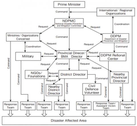
The third group was the Department of Disaster Prevention and Mitigation (DDPM). The mission of this agency is providing humanitarian assistance to the people (focusing on disaster preparedness, mitigation, and relief). Secondly, it is responsible for managing disaster-affected areas. Disaster plans are usually based on the national disaster master plan. The local disaster management plan was supported by the provincial DDPM authority to evaluate and prepare the response to the disaster. The DDPM has regional authority as a tool provider to respond to disaster events, but no decision-making authority. All preparedness and mitigation decisions depend primarily on the head of provincial governor as shown in Figure 4.
The DDPM was the data collector that determines the disaster response. This agency was assisted by UNDP in creating the information to map the disaster-affected areas. The map was used for preparedness planning, response, rehabilitation and recovery in anticipation of effective disaster management. Normally, the DDPM’s plan establishes is 5 years and it takes its time to collect the data and information and update in 5 years. In terms of flood management, the DDPM was not concerned with flood management in the urban area, but is looking for the ways to control the upper basin and manage the damage from the water disaster. Nevertheless, the damage was mainly in the urban area and more incentives should be provided also.
Source: DDPM, Ministry of Interior cited by Tanwattana [2]
Figure 4. Institutional agencies for disaster prevention and mitigation in Thailand
4.2.2 The focus group discussion (FGD)
The discussion of all stakeholders in case study can show the situation of hydrological risks and adaptive capacity in the CPRB. The participants from the organizations in Ayutthaya province participated in the discussions around thirty.
The representative of RID presented about Ayutthaya province and surrounding areas, the causes of water disaster, current hot topics, plans and the results of water disasters. There were two types of measures to cope with floods. First, non-structural measures such as overlap calendar of harvesting and planting, and monkey cheek areas have been implemented in seven areas of Ayutthaya province along the CPRB line. Monkey cheek areas such as Thung Makham Yong and Thung Phu Kao Thong maintained water gates in the natural channels and adding new water gates. He explained that communication is an important issue between relevant organizations and all stakeholders. The Line application to community leaders was applied. In addition, he indicated a system for thinking and planning, and forecast weather conditions system from relevant organizations were worked to determine the amount of precipitation and deal with the amount of water. He described the plan to build a new project that will directly transfer water namely Bang Ban- Bang Sai projects with a length of 22 kilometers.
The representative of DDPM revealed the disaster prevention and mitigation plan, which can also be found at the RID. The representative of DPT described the ways to provide the water management plan such as land use plan, laws and regulations, and risk assessment map. The roles and responsibilities of stakeholders in the province in managing water disasters showed that the RID aims to protect irrigated areas first before a water disaster occurs. Like the RID, the DDPM aimed to prevent and mitigate the disaster in three stages, namely before, during and after, which was consistent with the DDPM’s policy.
The representative of Ayutthaya City Municipality (ACM) can be separated into three groups: first, the head of the Technical Service and Planning Department; second, the head of the Fire Fighting and Relief Department; and third, the head of Rescue Department. They all have confirmed that they cannot release any plans to the society without the mayor’s permission. All the plans were appointed and sent out by the central government following the same pattern without integrating them. Moreover, in this part, the practitioners were mistaken in some tasks to fill in the facts. This indicated that the awareness of practitioners involved in disaster management especially flood management plan was inadequate and may lead to misunderstanding and ambiguity.
4.2.3 Community leaders
The community leaders were located near water bodies and outside the dyke. Respondents expressed that they are aware of flooding in their houses. During floods that last more than two weeks to one month, some members tried to renovate their houses with concrete. They confirmed the information from the local media and from the other members of the community.
The members of the communities knew the information before the arrival of the water and moved their property to the safe areas. During the first floods, no community-level organization was involved in the relief effort. Community leaders met with local organizations every month to discuss and pass on the information to each other. However, they confirmed that most members were not able to prepare and liaise with local authorities and others, so they took care of it by themselves. Support from government agencies came too late and was effective.
The content analysis from the key informants indicated that the responsibilities of the related agencies, for example, central government such as RID, HAII, DDPM, their roles, policies or plans were given from the national level or higher authority this led to lacking of integration among the relevant organizations. Furthermore, the lack of coordination and communication between organizations, and knowledge base for practitioners and local people were not enough and insufficient. Lastly, the duplication of the authority of the government agencies and the duplication of the information caused delay in performance.
4.3 Results of the perception on FMP
4.3.1 FGD’s results
According to Figure 5, the most frequent codes were A: Flood management policy and institutional framework, C: Roles and responsibility, and Perception on flood management planning. There was mention the codes A01, A02, and A03, about almost 1.37 fold of the interview, while the local people has less mention of Issue A. Simultaneously, C01, C02 and C03, the high mention by FGD almost 2 fold of the interview and local people. By the same, D01, D02 and D03, were equal by the interview and community leaders, while FGD was high mentioned.
The highlight of the Figure 5 was the less mentioned on E: Public participation. The E01 code was found that just three in the local people mentioned it, while E02 and E03, the was no mention. The interview and FGD mentioned about the public participation in flood management and integration public participation in FMP. That meant the community leaders can not involve in flood management planning process. The public participation was abandoned.
Source: Adapted data by coding analysis
Figure 5. The results from interview, FGD and community leaders on the 2011 flood
The FGD mentioned the Issue B: Flood disaster management with high score. The B01, and B02, were similar mentioned about knowledge and information of FMP and emergency management, while the operation system was less mentioned. At the B01, the was no mention from the local people, that meant the local people cannot assess the knowledge and information about FMP.
As mentioned above from the data can indicate that the existing flood management plan still have weakness such as emergency management, communication, coordination, public participation, and integration between relevant organization and all stakeholders to cope water disaster. The political uncertainty is the one factor to assign the duty to relevant organization including the operation system. Although, there are several organizations relevant in flood management but complicated roles and responsibilities led to delayed emergency management, planning, rescue the victims and communication among them to local people Therefore, the appropriate approach to deal with flood management need to apply in the existing flood management plan.
4.3.2 Perception on the flood management planning
The 15 participants were representatives of community leaders: 73.3% male and 26.7% female. They lived near the Lopburi River, Chao Phraya River, Muang Canal, Pasak River, Hantra Canal, and outside the dykes. The responses of community leaders in ACM on flooding events consisted of reports and activities on flooding events; activities before and during flooding and the relief system; activities after flooding; and compensation for flood victims, as shown in Table 4. The community leaders were in charge of communicating information from the local authorities to their members, but they did not intend to protect their property from the flood. Because of the information delayed and it was not real time so they did not to protect their proport in time. There was a lack of communication with local authorities to plan, prepare and protect for the flood situation.
Table 4. Participants’ characteristics for flood event, 2017
|
Characteristics |
Responses |
|
During flood event |
|
|
|
Two weeks to one and a half months |
|
-Households’s effects |
Most of communities located near river and canal were affected; in some areas all the houses in the community. |
|
-Impacts |
Most of the activities must be stopped. |
|
-Damages |
Members of the community tried to change, repair and adapt the material to build their houses. |
|
Before flood event |
|
|
-Information |
Local radio and social media |
|
- Preparation |
Some members move their property to the safe zone. No more role of communities leaders; they help save each other by themselves. |
|
-Support |
No preparation and linkage by ACM agencies; support from them came late and less effective. |
|
After flood |
|
|
-Organization |
No organization was involved in the relief system. |
|
-Communication |
Good relationship among community leaders and members. |
|
Compensation |
|
|
-Assessment process |
Members of the community filled up the form and submitted list of damages and costs to ACM agencies. There was no community participation in the determination of compensation; main responsibility was with the municipal officers. |
The communities rated the acceptability of the flood management plan with an average standard deviation (SD) of 3.06±0.53. They disagreed regarding the water resources management system indicating that it was so poor (2.13±0.64). They also focused on communication (1.47±0.64), participation (1.73±0.70), and integration (1.60±0.63). As shown in Table 5, the overall flood management plan in the area was poor and needed immediate improvement. The results showed that the perception on the flood management plan was rather poor and respondents were dissatisfied.
With the contradictory results of the central government regarding flood management, the process should be reviewed with related government agencies that deal with natural disasters and flood management in particular. The Flood Management Plan (FMP) should be reviewed by the Flood Risk Management Committee (FRMC) with involvement of representatives from different sectors dealing with flood management, including the local people who should know the plan or development plan and what will happen in their area. Of course, they agreed with the location of their houses from previous generations. They confirmed that they still live there and did not move because the flood events do not last long and they should live with the water as in the past.
4.4 The integrating SEA into FMP
From the results, we need to think about the context of the areas. The role of the local people and communication between the responsible government and other stakeholders should be an important issue. The government should be open to participation from all sectors. There are six factors affecting information policy and disaster management, namely operation system, political uncertainty, emergency management, communication, participation, and integration.
The hierarchical action is unclear with regards to management of the water resources level. The time for opening and closing of the sluice gates cannot be controlled because of the power of politicians. Emergency management is delayed only because of complicated government systems. Communication under the same umbrella and others should be consistent. The local practitioners and local people are hardly involved in flood management planning because most of the actions, policies and plans result from the central government, typically ‘top-down’, which is the basic management approach in the Thai context, abandon the public participation and integration.
Based on the theory of SEA, the process of sustainable development goals (SDGs) was recognized by half of the respondents as a component of the process. The goal of a SEA system is its potential ability to achieve sustainability. Most repondents stated that SEA should be multiple principles and should be more adaptable than EIA, which is the basis for developing more sustainable development goals and PPPS proposals.
The results regarding the benefits of the SEA process for the flood management in case study can be seen in Figure 6. This shows the community leaders’ agreement that emergency management must be done first $(\bar{X}=4.73)$, followed by communication $(\bar{X}=4.67)$ and participation $(\bar{X}=4.40)$. In addition, they indicated that participation in flood management planning was not accessible to the local community. Sharing information and opinion among the public, government and planners can lead to more awareness.
Table 5. Perceived satisfaction on the FMP
|
Issues |
X |
SD |
Strongly disagree% |
Disagree% |
Neutral% |
Agree% |
Strongly Agree% |
|
1. OS |
2.13 |
0.64 |
6.9 |
34.5 |
20.7 |
29.3 |
8.6 |
|
2. PU |
1.73 |
0.46 |
13.1 |
27.8 |
23.9 |
29.1 |
6.0 |
|
3.EM |
1.47 |
0.64 |
37.1 |
22.4 |
30.2 |
9.5 |
0.9 |
|
4.CO |
1.47 |
0.52 |
23.0 |
39.1 |
27.6 |
9.2 |
1.1 |
|
5.PA |
1.73 |
0.70 |
23.3 |
39.7 |
22.4 |
11.2 |
3.4 |
|
6.IN |
1.60 |
0.63 |
18.1 |
38.8 |
31.9 |
8.6 |
2.6 |
|
Total |
1.69 |
0.59 |
20.25 |
33.72 |
26.12 |
16.15 |
3.7 |
Notes: OS= Operation of system, PU= Political uncertainty, PA= Participation, IN= Integration, CO=Communication, EM= Emergency management, X= mean; SD= standard deviation
The government, on the other hand, sympathized that communication between agencies and others, emergency services and management, and work operation are very important (as $\bar{X}=4.62, \bar{X}=4.38, \bar{X}=4.19$ respectively). This shows that integrating SEA in management planning process can promote better practices. Respondents agreed with SEA is useful to address the environmental issues concerns in the first step to support decision making. They assumed that public participation in the planning process can improve by SEA process ($\bar{X}=4.4$ and $\bar{X}=3.92$). While integration issue will support to achieve integration of planning systems at all levels ($\bar{X}=3.73$ and $\bar{X}=3.92$).
Notes: OS= Operation of system, PU= Political uncertainty, PA= Participation, IN= Integration, CO=Communication, EM= Emergency management
Figure 6. The existing FMP in Ayutthaya
Similar to many countries, the benefits are in terms of achieving the environmental sustainability, integration, participation and cooperation on environmental issues during the planning process [28-30]. Thinking about the limitations to integrate SEA application into flood management planning in Thailand context, the lack of SEA legislation in the country’s national legislation has been named as the crucial problem. This fact makes it difficult to include spatial planning in the planning. Figure 6 reveals that the uncertainty of political system, capacity on SEA, and insufficient technical measures are further obstacles. Many international journals point out that some case study have carried out SEA on an optional process or action through national legislation including other provisions such as boards and cabinet or committee and higher decision makers, and advisory protocols [31].
The benefits of introducing SEA, it should be a mandatory such in countries are ensured by strategic actions with potential environmental impacts, managing adequate resources for SEA application, and determining the suitable legal force to achieve results. Some respondents indicated that a plain legal and action guideline can confirm the usefulness of SEA in practice. Moreover, providing a legal framework and a prescribed process suggest that there is no perfect way to implement SEA application, it depends on the condition of country. Nonetheless, a legal basis for SEA is crucial as it can improve the SEA process and practices effectively, in developing countries.
Political uncertainty was perceived as limiting by some of the respondents representing community leaders and government agencies $(\bar{X}=3.60$ and $\bar{X}=3.92)$. The different agencies and part of the society disagreed with the economic policies. Some facts suggested that there is no continuity and no strong political force to drive the integration and implementation of SEA in flood management planning.
Powerful political forces which are considered the crucial factors for the approval process can support and drive the strong environmental issues. It is significant to allow higher priority to consider the issues and make the decision process. Respondents argued that existing flood management plans and practices by multiple government agencies are poorly coordinated and lacking of an integrated system. They felt that the gaps in the government agency’s plans should be overhauled. Poor coordination is a regular procedure in the Thailand context.
Respondents indicated that it is critical to coordinate the SEA process, that stakeholders perceive themselves as realistic persons in their responsibilities in policy making and planning. In addition, respondents felt that effective implementation and practice of the SEA process and procedures provide sufficient results. However, implementation guidelines and reliable approaches were seen as potentially important to the application of SEA. In addition, respondents indicated that SEA will be a new trend and that knowledge of approaches will be unlimited. Therefore, it is important to have action guidelines that demonstrate to planners, decision makers, and stakeholders with the ways to implement the SEA process.
Respondents indicated the lack of sufficient action guidelines was a barrier to apply SEA. The header in communities indicated that inadequate and insufficient of planning and participation could be refused by decision makers. In addition, respondents revealed that an accurate understanding could be an important issue for the SEA application. In addition, they felt that training and qualified professionals also play roles in the SEA application. According to the finding of the survey related to the obstacles in integrating SEA into planning, especially in the case of Ayutthaya, uncertain political party will be cited as the most important obstacle.
The focus group discussions revealed that the participants perceive themselves as realistic persons responsible for planning and implementation. Some of them still confirmed that the roles assigned by the higher authority are in the right way, but they agreed that there is a lack of coordination. So, there should be integrated among relevant planning agencies.
All members of the audience felt that there is a need to change the existing planning systems to address the challenges that development faces in terms of sustainability development. They expressed SEA should be proposed for the action guideline of the new framework to raise the environmental awareness among all stakeholders. In flood management planning in Ayutthaya, there is a need to improve the strategic framework and to adapt and integrate better approaches to manage climate-related risks. This will eventually help flood management to become more effective and should be adapted to the near future.
4.5 Applying SEA and FMF
Developing countries have an adequate PPP planning for environment and society with focusing on key concerns provided in the policy instruments, as the use of SEA was not an option previously for a long time. Therefore, the critical keys for finding solutions were presented such as the legal provisions for SEA to be integrated into existing plan and the suitable model for integrating SEA and flood management planning together.
The outcomes suggested that it is better to integrate SEA into the planning using an appropriate legal framework. In this way, SEA can be easily designed to suit the relevant government agencies. A precise legal framework is then useful at least in providing regulatory context for practicing SEA, as well as in helping promote SEA conditions that can be systemically implemented. The legal will indicate to stakeholders and their roles and responsibilities in SEA application. This approach will require a variety of agreements among relevant agencies, particularly the National Economic and Social Development Council, the National Environment Board, and the Ministry of Natural Resources and Environment.
Although SEA in Thailand was introduced more than 15 years ago, it is still a concept that will support, improve and facilitate the decision-making process in PPPs. It should be enforced SEA into the existing legislation and flood management plan. The relevant agencies should be responsible for implementation. In addition, 4 out of 7 respondents from government agencies indicated that SEA should be included in the existing environmental laws and should be integrated into the national master plan by the NESDB to guide the preparation of national strategic plans. The competent authorities under the Prime Minister are legally empower to planning, implementation, monitoring and evaluation of the master plans.
Respondents indicated that an overarching authority for SEA should be found to response for water resource management, natural disaster prevention and mitigation, and environmental management under the Prime Minister and Deputy Prime Minister and it should include SEA in the national master plans. This authority could guarantee that the SEA process is carried out with public and stakeholders participation. In addition, this authority would monitor the management plans, evaluation steps, follow up and forward the SEA report, review, and recommendation to decision makers. This authority should be found in cooperation with the agencies to ensure that the SEA studies are considered at an early stage. This commission would be responsible for making decisions based on the findings and recommendations from the SEA document. If the proposed plan requires a SEA study, the High Commission should establish an Emergency Management and Communications team to prepare the study.
There are three models for integrating SEA into the flood management planning process which can be considered as ex-post with separate, partially integrated, and fully integrated. The first model is an ex-post assessment and is separate from the preparation of strategic actions. Second, it is partially integrated into the preparation of strategic actions. Next, it is fully integrated into the preparation of strategic actions. However, the respondents consented that the separate model cannot promote the benefits extremely. Integrated planning receives the most support, but it is feasible with the excellent coordination of agencies.
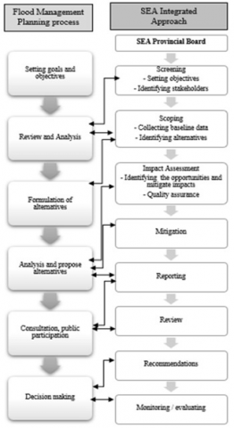
The Thai government has no experience in fully integrating environmental considerations into the planning process. The full integration of SEA requires a transformation of the present structure which will only occur in the long term measure. In a different way, respondents indicated that a viable approach at the present would be partially integrate into strategic action plan and then decision making. The partially integrated model runs side by side with the urban planning process (see Figure 7). It can work deliberately when there is good correspondence at all stakeholders. It would also include data sharing, coordination, immediate management, public participation, operation, and expert integration.
The SEA stages can be involved by JICA as important decision points in Thailand’s flood management plan. The process guidelines have been used in a partially integrated model in Thai context, and decision makers can collaborate and connect multiple issues to the specific stages. One of the SEA reports will be prepared for the High Commission for review, approval, implementation, monitoring and evaluation.
Figure 7. The SEA integration into FMP in Ayutthaya province
The spatial planning consideration in Thailand such as flood management planning is difficult and meets various barriers such as tools, insufficient environmental studies, integration and coordination among agencies, stages of bureaucracy, stakeholders and the public participation. As the content analysis, coding analysis, the interviews, FGD, and local people can be summarized to show that SEA can be the appropriate approach to integrate into FMP for Thailand by the case study of Ayutthaya province.
5.1 Existing FMP in Thailand
From the evidence analyzed of the case study, it shows that FMP process started significantly only after the 2011 mega flood in Thailand. Ayuthaya province is one area that located in the shallow flood plain of the basin and is susceptible to flivial flooding. Ayutthaya experienced a devasting flood when it was inundated for a month and the water depth exceeded 4 metres. As FMP, it is found that FMP was appointed by the central government in the national level, there is no clear and strict practical pattern. All interviewees had shown consensus in the mega flood-impacted their organization structure. There is institutional arrangement that designate organizations responsible for FMP to deal flood disaster at all levels. Organizations in water disaster management need to be involved in spatial planning and urban planning.
The results of this study are compatible with Singkran’s study on developing a strategic flood risk management framework in Thailand [15]. They indicated that FM in Thailand relies on structural measures and emergency management which not cover during the flood event. The sustainable development of water resources based on flood and drought risks and climate change was presented in order to ensure that the risks decrease [46].
5.2 SEA in FMF
Practical implementation for sustainable development, integration of environmental aspects in the initial stages of planning and decision-making, increased public participation, and contribution to improve the decision-making process. These were the advantages of integrating SEA application into spatial planning [47-49]. The lack of SEA legislation was cited as the huge barrier, political uncertainty, the SEA process, and exact information accession.
To better integrate SEA into planning process, SEA needs to be integrated into a suitable legal and a good framework [50]. As the results showed, a suitable legal can be easily and smoothly formed for various sectors. In addition, an obvious legal framework will be profitable to action and to provide a minimal regulatory context [51]. A legal basis framework will help to create basic SEA requirements and guidelines that can be implemented more systematically [52, 53].
The authors use the results, the global literature to suggest an institutional framework. The Flood Management Planning Framework (FMPF) was proposed to establish an overarching authority for SEA under the umbrella of the Prime Minister, e.g., the National Resources and Environmental Policy and Planning, the National Environmental Board (NEB), the National Resources and Environmental Policy and Planning, Strategic Plan (2018-2038), Disaster Prevention and Mitigation Act of Thailand, B.E.2550, the 12th National Economic and Social Development Plan (2017-2021), the Environmental Quality Management Plan, the National Strategy Committee (NSC) with the National Strategy (2018-2037), the National Strategy Act B.E.2560 and the draft 13th National Economic and Social Development Plan (2022-2026) [54]. The National Strategy (2018-2037) includes the way to ensure that the prospect of becoming “a developing country with security, prosperity, and sustainability in accordance with the philosophy of sufficiency economy” is achieved, and the Royal Irrigation Department Strategic Plan (2561-2580 B.E.). This high commission could confirm that the SEA process is being addressed with the top beneficial practices. In addition, this commission would be responsible for reviewing and evaluating the plan, making recommendations or disapprovals, and monitoring and evaluating both the SEA report and the plan.
As the 2011 mega flood of Thailand, it could change the flood management planning system in the country. The study found that the Civil Defense Act 1979 authorized the central government structure to be responsible for overall disaster management. The National Civil Defense Plan 2005 was implemented based on the Civil Defense Act 1979. Thus, the disaster Prevention and Mitigation Act 2007 authorized several organizations at different levels to be responsible of disaster management. The implementation of the central policy into practice was complicated and overlapped. In addition, the participation of all stakeholders was not encouraged from the beginning. For Ayutthaya province as the pilot case, FMP needs to improve the framework and integration approaches and consider climate-related risks. The flood management should focus on the role and responsibities to directly work and drive the integration SEA into FMP at all stakeholders more successful. It should be established the SEA Provincial Board to supervise the flood management planning and SEA process run parallel and integrated to the same goal.
It is suggested that SEA is the better tool and modern tendency to promote integration in the right way and to set priorities for practical implementation to achieve sustainability and better quality of life.
The author presents the following roadmap for the next action steps: (a) lay out the research as the subject of the critical issues; (b) determine the goal of the strategic approach; (c) initiate a comprehensive analysis to make proposals for the legal framework in Thailand; (d) examine the legal and institutional framework based on the proposed SEA approach; (e) establish a new institutional structure; and (f) promote public participation at all levels. Even though the integration SEA into FMP is a partially integrated model in this study. Further studies, SEA should be done as full integration into planning process to better integrate SEA into FMP in Thailand. Furthermore, it should be establishing an appropriate legal framework to make it mandatory and the new appropriate authority to directly work and should be under the umbrella of the Prime Minister and regarding the 20 year National Water Management Master Plan (2018-2037), and the National Climate Change Master Plan (2015-2050). This will make more effective and able to respond in the event of a disaster in the future.
The authors thank the School of Environmental, Resource and Development, Asian Institute of Technology for support in the form of research facilities and time to conduct this study; and government agencies (Department of Disaster Prevention and Mitigation, Royal Irrigation Department, Department of Water Resources, Thai Meteorological Department, and Ayutthaya City Municipality) for providing relevant data.
[1] Thanvisitthipon, N. (2017). Impact of repetitive floods and satisfaction with flood relief efforts: A case study of the flood prone districts in Thailand’s Ayutthaya province. Climate Risk Management, 18: 15-20. https://doi.org/10.1016/j.crm.2017.08.005
[2] Tanwattana, P. (2018). Systematizing community-based disaster risk management (CBDRM): Case of urban flood-prone community in Thailand upstream area. International Journal of Disaster Risk Reduction, 28: 798-812. https://doi.org/10.1016/j.ijdrr.2018.02.010
[3] Hungspreug, S., Khao-uppatum, W., Thanopanuwat, S. (2000). Flood Management in Chao Phraya river basin. In: Proceedings of the International Conference on The Chao Phraya Delta: Historical Development, Dy namics and Challenges of Thailand’s Rice Bowl, Bangkok, Thailand, pp. 293-312.
[4] The World Bank. Thai Flood: Overview Rapid Assessment for Resilient Recovery and Reconstruction Planning. http://documents.worldbank.org/curated/en/677841468335414861/Overview, accessed on Nov. 20 2016.
[5] Tanwattana, P., Murayama, H. (2014). Community planning and the policy process for regional revitalization against disasters: Thailand’s readiness and the Japanese experience. J. Policy Sci, 21(2): 27-42.
[6] Roachanakanan, T. (2012). Floodways and flood prevention in Thailand: reflections of the great flood in 2011. In Proceedings of the World Flood Protection, Response, Recovery and Drawing up of Flood Risk Management Conference, Bangkok, Thailand, 2012. http://www.dpt.go.th/csp/images/stories/pdf/disaster/FloodwaysPreventionThailand.pdf, accessed on Aug. 20 2016.
[7] Koontanakulvong, S. (2012). Thailand Floods 2011: Causes and future management system. Society for Social Management Systems Internet Journal, 5. http://ssms.jp/img/files/2019/04/sms12_4498.pdf, accessed on Aug. 20 2016.
[8] Chanjirawuttikun, N. (2016). Flood disaster management in Thailand: Summary and issues. Policy Brief. Land Development Department (in Thai), 2016, http://prp.trf.or.th/trfpolicy-brief/, accessed on Aug. 20, 2016.
[9] Jukrkorn, N., Sachdev, H., Panya, O. (2014). Community-based flood risk management lessons learned from the 2011 flood in central Thailand. Flood Recovery Innov. Response IV, 184: 75-86, http://dx.doi.org/10.2495/FRIAR140071
[10] Ward, P.J., Pauw, W.P., Buuren, A.V. (2013). Governance of flood risk management in a time of climate change: The cases of Jakarta and Rotterdam. Environmental Politics, 22(3): 518-536. https://doi.org/10.1080/09644016.2012.683155
[11] Chinnarasri, C., Porhaew, K. (2015). An organization for improving flood resilience in Thailand. Water Management, 168(2): 97-104. https://doi.org/10.1680/wama.14.00064
[12] Attavanich, W. (2018). The effect of climate change on Thailand’s agriculture. 7th International Academic Conference Proceedings. https://www.researchgate.net/publication/262067789, accessed on 20 August 2018.
[13] Limsakul, A., Limjirakan, S., Sriburi, T. (2016). Assessment of Extreme weather events along the coastal areas of Thailand. http://kb.psu.ac.th/psukb/handle/2016/16715.
[14] Naruchaikusol, S. (2016). Climate change and its impact in Thailand: A short overview on actual and potential impacts of the changing climate in Southeast Asia. Trans Re Fact Sheet No. 2. www.transre.org/application/files/7415/4411/3781/Climate_Change_in_Thailand_TransRe_Fact_Sheet_No._2.pdf.
[15] Singkran, N. (2017). Flood risk management in Thailand: Shifting from a passive to a progressive paradigm. International Journal of Disaster Risk Reduction, 25: 92-100. https://doi.org/10.1016/j.ijdrr.2017.08.003
[16] Nakamura, S. (2016). Damage from and Resilience Against the 2011 Thai Flood. In Hasashi et al. (Eds.), Disaster Resilience Cities: Concepts and Practical Example, Butterworth- Heinemann. https://doi.org/10.1016/B978-0-12-809862-2.00005-X
[17] Penning-Rowsell, E.C., Johnson, C., Tunstall, S. (2017). Understanding policy change in flood risk management. Water Security, 2: 11-18. https://doi.org/10.1016/j.wasec.2017.09.002
[18] Sayers, P., Gersonius, B., Heijer, F, D. Klerk, W.J., Fröhle, P., Jordan, P., Ciocan, U.R. Rijke, J. Vonk, B., Ashley, R. (2021). Towards adaptive asset management in flood risk management: A policy framework. Water Security, 12: 100085. https://doi.org/10.1016/j.wasec.2021.100085
[19] OECD. (2010). Strategic environmental assessment and adaptation to climate change. Organization for Economic Co-operation and Development, OECD, Paris, France.
[20] Sadler, B., Verheem, R. (1996). Strategic environmental assessment: Status, challenges and future directions. Ministry of Housing, Spatial Planning and the Environment. https://doi.org/10.4337/9781848445062.00019
[21] Jones, C., Baker, M., Carter, J., Jay, S., Short, M., Wood, C. (2005). Strategic Environmental Assessment: and Land Use Planning: An International Evaluation. Earthscan, London.
[22] Bond, A.J., Morrison-Saunders, A. (2012). Sustainability appraisal: Jack of all trades, master of none? Impact Assessment & Project Appraisal, 27(4): 321-329. https://doi.org/10.3152/146155109X479422
[23] Hameed, K. (2017). Strategic Environmental Assessment for better flood risk planning in Pakistan. Doctoral Thesis, Technische Universitat, Berlin. http://dx.doi.org/10.14279/depositonce-5791
[24] Fischer, T. (2007). Theory and practice of strategic environmental assessment: Towards a more systematic approach. TwoEA-M - Enhancing Attractiveness of Environmental Assessment and Management Higher Education - EC Erasmus Mundus, London: Earthscan. https://doi.org/10.4324/9781849775922
[25] Wilson, E., Piper, J. (2010). Spatial Planning and Climate Change. London: Routledge.
[26] Larsen, S.V., Kørnøv, L., Driscoll, P. (2013). Avoiding climate change uncertainties in strategic environmental assessment. Environmental Impact Assessment Review, 43: 144-150. https://doi.org/10.1016/j.eiar.2013.07.003
[27] Posas, P.J. (2011). Exploring climate change criteria for strategic environmental assessments. Progress in Planning, 75(3): 109-154. https://doi.org/10.1016/j.progress.2011.05.001
[28] Therivel, R., Wilson, E., Thompson, S., Heaney, D., Pritchard, D. (2013). Strategic Environmental Assessment. London: Earthscan. http://dx.doi.org/10.4324/9781315070339
[29] Carter, J.G., White, I., Richards, J. (2009). Sustainability appraisal and flood risk management. Environmental Impact Assessment Review, 29(1): 7-14. https://doi.org/10.1016/j.eiar.2008.06.003
[30] Elling, B. (2008). Rationality and the Environment: Decision-Making in Environmental Politics and Assessment, London: Earthscan. https://doi.org/10.4324/9781849772273
[31] Morrison-Saunders, A., Fischer, T. (2006). What is wrong with EIA and SEA anyway? A sceptic’s perspective on sustainability assessment. Journal of Environmental Assessment Policy and Management, 8(1): 19-39. https://doi.org/10.1142/S1464333206002372
[32] Sheate, W., Dagg, S., Richardson, J., Aschemann, R., Palerm, J., Steen, U. (2013). Integrating the environment into strategic decision-making: Conceptualizing policy SEA. European Environment, 13(1): 1-18. https://doi.org/10.1002/eet.305
[33] Gibson, R.B. (2006). Beyond the pillars: Sustainability assessment as a framework for effective intergration of social, economic and ecological considerations in significant decision making. Journal of Environmental Assessment Policy & Management, 8(3): 259-280. https://doi.org/10.1142/s1464333206002517
[34] The Prime Minister, Office of the Council of State. (2018). Eastern special development zone Act B.E. 2561 (in Thai) The Royal Thai Government Gazette, No 135, Section 34a Thailand: Cabinet and Royal Government Gazette Publishing Office. www.krisdika.go.th/data/document/ext845/845318_0001.pdf.
[35] Yusook, S. (2018). Part 1: The roles of strategic environmental assessment (SEA) (in Thai). In: The seminar on SEA and water resource management in Thailand. Investigating the effectiveness of strategic environmental assessment in Thailand. Impact Assessment and Project Appraisal, 37(3-4): 356-368. https://doi.org/10.1080/14615517.2019.1595941
[36] Sandang, C., Poboon, C. (2018). Strategic environmental assessment in Thailand. Journal of Community Development Research (Humanities and Social Sciences), 11: 90-100.
https://www.journal.nu.ac.th/JCDR/article/view/1980/1298.
[37] Chanchitpricha, C., Morrison‐Saunders, A., Bond, A.J. (2019). Investigating the effectiveness of strategic environmental assessment in Thailand. Impact Assessment and Project Appraisal, 37(3-4): 356-368. https://doi.org/10.1080/14615517.2019.1595941
[38] Victor, D., Agamuthu, P. (2014). Policy trends of strategic environmental assessment in Asia. Environmental Science & Policy, 41: 63-76. https://doi.org/10.1016/j.envsci.2014.03.005
[39] Wirutskulshai, U., Sajor, E., Coowanitwong, N. (2011). Importance of context in adoption and progress in application of strategic environmental assessment: Experience of Thailand. Environ Impact Assess Rev, 31(3): 352-359. https://doi.org/10.1016/j.eiar.2011.01.001
[40] Department of Water Resources. The River basin in Thailand. https://www.dwr.go.th, accessed on 20 August 2018.
[41] Fisher, C. (2021). Map of a) Thailand; b) the extended Bangkok metropolitan region; and c) the Bangkok metropolitan region. Cited by Marks, D. and Breen, M. The Political Economy of Corruption and Unequal Gains and Losses in Water and Sanitation Services: Experiences from Bangkok. Water Alternative, 14(3): 795-819. https://water-alternatives.org/index.php/alldoc/articles/vol14/v14issu3/645-Q14-3-8/file , accessed on Dec. 20, 2021
[42] Map of Ayutthaya. http://www.ayutthaya.go.th/, accessed on 20 August 2021.
[43] McLeod, S. Likert scale definition, examples and analysis. https://www.simplypsychology.org/. Available online: https://www.simplypsychology.org/blog/tag/linkert-scale/, accessed on Nov. 18, 2020.
[44] Robinson, S. Ama Nyame-Mensah. Using & Constructing Likert Scales in Evaluation Research. https://www.simplypsychology.org/blog/tag/linkert-scale/, accessed on 18 November 2020.
[45] Paulus, T.M., Pope, E.M., Woolf, N., Silver, C. (2019). It will be very helpful once I understand ATLAS.ti: Teaching ATLAS.ti using the Five-Level QDA method. Int. J. Soc. Res. Methodol., 22(1): 1-18. https://doi.org/10.1080/13645579.2018.1510662
[46] Chitradol, R., Boonya-aroonnet, S., Thanapakpawin, P. (2009). Risk management of water resources in Thailand in the face of climate change. Sasin Journal Management, 15: 64-73.
https://tiwrm.hii.or.th/web/index.php/knowledge/128-hydro-and-weather/295-riskmanagementclimate.html.
[47] Fischer, T.B., Kidd, S., Jha-Thakur, U., Gazzola, P., Peel, D. (2009). Learning through EC directive-based SEA in spatial planning? Evidence from the Brunswick region in Germany. Environ. Impact Assess. Rev., 29(6): 421-428. https://doi.org/10.1016/j.eiar.2009.03.001
[48] Thérivel, R., Partidario, M. (1999). The future of SEA. In Perspectives on Strategic Environmental Assessment, Partidario, M. and Clark, R. (Eds), Boca Raton: CRC Press, 271-280.
[49] Fischer, T.B. (2002). Strategic environmental assessment in transport and land use planning. Environmental Impact Assessment Review, 23(1). https://doi.org/10.1016/S0195-9255(02)00090-2
[50] Fischer, T., Seaton, K. (2002). Strategic environmental assessment: Effective planning instrument or lost concept. Plann. Pract. Res., 17(1): 31-44. https://doi.org/10.1080/02697450220125069
[51] Fischer, T. (2007). Theory and practice of strategic environmental assessment: Toward a more systematic approach. TwoEA-M - Enhancing Attractiveness of Environmental Assessment and Management Higher Education - EC Erasmus Mundus. https://doi.org/10.4324/9781849775922
[52] João, E. (2005). Key Principles of SEA. In: Schmidt, M., João, E., Albrecht, E. (eds) Implementing Strategic Environmental Assessment. Environmental Protection in the European Union, 2. Springer, Berlin, Heidelberg. https://doi.org/10.1007/3-540-27134-1_1
[53] Runhaar, H., Driessen, P. (2007). What makes strategic environmental assessment successful environmental assessment? The role of context in the contribution of SEA to decision making. Impact Assessment and Project Appraisal, 25(1): 2-14. https://doi.org/10.3152/146155107X190613
[54] NESDC. (2021). Strategic Environmental Assessment: SEA (in Thai). Bangkok (Thailand): Office of National Economic and Socila Development Council. https://www.nesdc.go.th/download/article/NESDC_SEA%20GL_2021, assessed on Jan. 18, 2022.