Noverman Duadji* | Novita Tresiana | Aling Mai Linda Sari Putri | Melya Riniarti
© 2022 IIETA. This article is published by IIETA and is licensed under the CC BY 4.0 license (http://creativecommons.org/licenses/by/4.0/).
OPEN ACCESS
This study analyzes the success of implementing a conservation village in obtaining environmental support in forest management in the Bukit Barisan National Park. This research uses a qualitative case study method, reinforced by a desk review of relevant research literature. Interviews and focus group discussions were conducted to gain a deeper understanding of how successful policy implementation was Conservation Village in economic and conservation-based community empowerment in the TNBBS area. The success of policy implementation is reviewed by analysis of marketing policies and further analysis using a matrix of environmental reactions to policy implementation. The study results indicate that marketing policies in terms of policy acceptance and adoption have failed/successful and in terms of strategic readiness, successful with the establishment of a conservation task force tasked with managing and monitoring forest products and implementing this conservation village agreement. The community is an important part of the policy. The village government fully supports being the implementer of the policy. It is manifested in the form of providing access and facilities and for NGOs to provide full support through the provision of budgetary resources and facilitators for training and counseling related to building awareness to save forests.
policy implementation, village preservation, environmental support, awareness and participation
Indonesia is a country that has a large forest area, so it can be said as the lungs of the world. In this regard, the government's attention to the obligation to conserve forests is a top priority that must be implemented, considering that the function of forests in Indonesia plays a major role in meeting human needs [1]. As a conservation forest area that also has an ecological function, the Bukit Barisan Selatan National Park is a national park aimed at protecting the tropical rain forests of the island of Sumatra and the natural wealth it contains [2]. UNESCO has declared Bukit Barisan Selatan National Park a World Heritage Site [3]. Bukit Barisan Selatan was declared a Wildlife Reserve in 1935 and became a National Park in 1982. Initially, the area of the park was 356,800 hectares. However, the current park area calculated using GIS is approximately 324,000 hectares. Bukit Barisan Selatan National Park is located at the southwest tip of the Sumatran region [4]. Seventy percent of the park (249,552 hectares) belongs to the administration of the West Lampung region and the Tanggamus region, both of which are members of Lampung Province [5]. The rest of the park covers an area of 74,822 hectares (23% of the total park area) and is located in the Kaur area of Bengkulu province. South Sumatra is also very important for overlapping park boundaries with provincial boundaries. Both of which are members of Lampung Province. The rest of the park covers an area of 74,822 hectares (23% of the total park area) and is located in the Kaur area of Bengkulu province. South Sumatra is also very important for overlapping park boundaries with provincial boundaries. Both of which are members of Lampung Province. The rest of the park covers an area of 74,822 hectares (23% of the total park area) and is located in the Kaur area of Bengkulu province [6]. South Sumatra is also very important for overlapping park boundaries with provincial boundaries. The management status of the Bukit Barisan Selatan National Park was originally a Wildlife Reserve Area. Then 2007, In 2007, the South Sumatra Wildlife Reserve area was declared a TNBBS area until now. Bukit Barisan Selatan National Park has some of Sumatra's most recently protected lowland forests [7]. It is extremely rich in biodiversity and is home to three of the world's most threatened large mammals: the Sumatran elephant (less than 2000 are still alive today).
Bukit Barisan Selatan National Park is included in the Global 200 Ecoregions, which is the most striking ranking of terrestrial, freshwater, and marine habitats on earth from a biological point of view made by the World Wide Fund for Nature or WWF, which is a non-governmental international affairs organization that deals with conservation, research, and restoration of the environment and forests [8]. This park was highlighted as a priority area for Sumatran rhino conservation through the Asian Rhino and Elephant Action Strategy (AREAS) program from WWF. In addition, WWF, in collaboration with IUCN and WCS, has identified the Bukit Barisan Selatan National Park as a Tiger Conservation Unit, which is the most important forest area for conservation in the world. Finally, in 2002, UNESCO selected this area to be proposed as a World Heritage Cluster Mountain Area along with the Gunung Leuser and Kerinci Seblat National Parks [9]. Bukit Barisan Selatan National Park is also one of three national parks in Sumatra, the highest priority for the Tiger Conservation Unit. It is also the only national park with the most extensive lowland forest ecosystem in the tropical rainforests of Southeast Asia [10]. In addition, this national park has a strategic function as a life support system area whose role is very important for the surrounding community because this area is a catchment area.
Using the Field School Strategy, efforts are being made to maintain a sustainable source of livelihood in the southern Bukit Barisan National Park. This strategy aims to provide understanding, skills, and encourage farmers to implement sustainable agriculture. In the buffer zone of the Bukit Barisan Selatan National Park, it can be seen that there has been significant progress since the “Coffee and Conservation” campaign was conducted in early 2007, which was part of the continuation strategy of the field school [11]. Every coffee company is starting to adopt and support sustainable agriculture efforts. They started buying coffee commodities from legal areas. Field School Assistance Activities impact three aspects, namely technical, social and political. Technically plant cultivation, there is an understanding among farmers about the importance of plant ecology. They also have the skills to conduct trials and innovations for better land management. While the use of chemicals such as fertilizers and drugs can be reduced, production will be more stable, and profits will increase [12]. In addition to strengthening alternative sources of livelihood for farmers, this mentoring activity trains farmers to be able to take risks and opportunities while their innovations are related to efforts to increase biodiversity around the garden, poisoning, health risks, and reducing the final contamination rate considering that this area has at least 23 major rivers and hundreds of tributaries that drain water from the national park to downstream areas along the coast of Tenggamus Regency, Lampung. West, and South Bengkulu, so that this strategy will not affect the quality of existing water resources. And from the social aspect, the use of this strategy encourages collaboration between farmers and between farmer groups, and there is a significant improvement in the way farmers communicate, and farmers become more independent in their problem-solving abilities, and can encourage the emergence of study groups at the farmer level and extension services from farmers to farmers. Meanwhile, from the political aspect of the use of this strategy, it is hoped that there will be an increase in the ability of farmers in matters relating to negotiations so that it can make it easier for farmers in bargaining activities between farmers and traders and their use of this strategy can increase their awareness in any policy stipulations. Previous research has never examined the effectiveness of conservation villages using marketing policies and environmental reactions (resources and actor values). Marketing analysis and understanding the types of environmental reactions will be useful for increasing awareness and participation as an aspect of sustainable forest management [13].
2.1 Forests and forest conservation areas
Forests are natural resources that provide various benefits for human welfare, both benefits that can be felt directly or indirectly by humans. The government determines certain areas to be used as production forest areas, protected forests, or conservation forests [14]. Conservation forest, which is a conservation area according to Law 41 of 1999 concerning forestry in Chapter I Article 1, states that forest areas with specific characteristics have the main function of preserving the diversity of plants and animals and their ecosystems. Conservation areas benefit the government and the community's economic activities, especially as natural tourist sites. Nature tourism activities in Nature Tourism Parks tend to be mass tourism activities. This mass tourism is economically profitable but can lead to a negative Pekon Conservation Agreement on conservation areas. Tourism activities in conservation areas tend to increase along with increasing awareness of nature conservation. Increasing nature-themed tourism such as leisurely walks in the wild/hiking, hiking/trekking, or mountain biking is a new trend in people's lives which ultimately has an ecological CCP in forest ecosystems.
Natural conservation forest areas can be used sustainably, one of which is through the use of environmental services in the form of nature tourism activities. Several types of nature conservation areas include National Parks, Grand Forest Parks, and Nature Tourism Parks [15, 16]. According to Government Regulation Number 28 of 2011 concerning Management of Nature Reserves and Nature Conservation Areas, in Article 10, the criteria for Natural Tourism Parks include: 1) having natural attractions in the form of plants, animals or natural scenery, natural phenomena, and unique geological formations; 2) has a sufficient area to ensure the preservation of the potential and natural attractions that can be utilized for tourism and nature recreation; 3) surrounding environmental conditions support efforts to develop natural tourism. According to Alikodra [17], the management of conservation areas aims to prevent damage to the function of the environmental order so that it can support social needs and improve the community's economy around the conservation area [18]. With this management objective, it will be followed by enhancing the environmental functions of soil, water, climate, plants, and animals and the historical and cultural values of the nation [19]. Besides, maintaining the diversity of plants, animals, ecosystem types, and the uniqueness of nature so that the function of the environmental order can be maintained. According to Trudgill [20], conservation areas have a very important role in sustainable development, namely: first, they have an important role in producing clean water sources needed by humans, industrial growth, agriculture and irrigation, and so on; second, has an important role for the growth of the foreign exchange and local revenue; third, has a role in food security, poverty alleviation and fourth, has a role for the protection and as a center of biological wealth. The existence of protected forests is a state asset that is managed with the aim of providing the most significant benefit to humankind, which must be preserved and grateful for as a gift from God Almighty. The benefits of forests are substantial, especially for people who live around the forest and in the forest. This community is highly dependent on forest resources to meet their daily needs and has a role in protecting and as a center of biological wealth. The existence of protected forests is a state asset that is managed to provide the most significant benefit to humankind, which must be preserved and grateful for as a gift from God Almighty. The benefits of forests are substantial, especially for people who live around the forest and in the forest. This community is highly dependent on forest resources to meet their daily needs and has a role in protecting and as a center of biological wealth. The existence of protected forests is a state asset that is managed with the aim of providing the most significant benefit to humankind, which must be preserved and grateful for as a gift from God Almighty. The benefits of forests are substantial, especially for people who live around the forest and in the forest. This community is highly dependent on forest resources to meet their daily needs. This community is highly dependent on forest resources to meet their daily needs and has a role in protecting and as a center of biological wealth. The existence of protected forests is a state asset that is managed with the aim of providing the greatest benefit to humankind, which must be preserved and grateful for as a gift from God Almighty. The benefits of forests are very large, especially for people who live around the forest and in the forest. This community is highly dependent on forest resources to meet their daily needs. This community is highly dependent on forest resources to meet their daily needs and has a role in protecting and as a center of biological wealth. The existence of protected forests is a state asset that is managed with the aim of providing the greatest benefit to humankind, which must be preserved and grateful for as a gift from God Almighty. The benefits of forests are very large, especially for people who live around the forest and in the forest. This community is highly dependent on forest resources to meet their daily needs. The existence of protected forests is a state asset managed to provide the greatest benefit to humankind, which must be preserved and grateful for as a gift from God Almighty. The benefits of forests are substantial, especially for people who live around the forest and in the forest. This community is highly dependent on forest resources to meet their daily needs. The existence of protected forests is a state asset that is managed to provide the most significant benefit to humankind, which must be preserved and grateful for as a gift from God Almighty. The benefits of forests are very large, especially for people who live around the forest and in the forest. This community is highly dependent on forest resources to meet their daily needs.
2.2 Environmental support in successful forest management
One part of the public policy process is the implementation of public policy. The public policy analysis section usually examines the relationship between a policy and a problem, the content of the policy, examines what policymakers do and do not do, and the consequences that will be made (outputs) of a policy. Policy analysis is basically a form of engineering and refinement of a policy [21]. Iqbal explains the implementation actors who have the impact and/or who are affected by the policy programs and development activities. They can be men or women, communities, socioeconomic groups, or institutions in various dimensions at every level of society. In general, the role of actors in implementation is divided into three, namely the government, the private sector, and the community [22]. Wakka revealed that the role of actors in the implementation of a policy or program is influenced by the power and interests, resources, and values of actors [23]. According to Yakin, four elements need to be considered to analyze the success of the actor's role in implementing a policy, namely as follows: a) actor participation, namely by assessing how the role of the actor is concerned in implementing a policy; b) the actor's perspective, namely by assessing how the actor understands the program; c) accessibility of actors, namely by assessing how actors access in program implementation; and d) determination of action, namely by assessing how the role of the actor in determining the action [24]. Four elements need to be considered to analyze the success of the actor's role in implementing a policy, namely as follows: a) the participation of actors, namely by assessing the role of the relevant actors in implementing a policy; b) the actor's perspective, namely by assessing how the actor understands the program; c) accessibility of actors, namely by assessing how actors access in program implementation; and d) determination of action, namely by assessing how the role of the actor in determining the action. Four elements need to be considered to analyze the success of the actor's role in implementing a policy, namely as follows: a) actor participation, namely by assessing how the role of related actors in implementing a policy; b) the actor's perspective, namely by assessing how the actor understands the program; c) accessibility of actors, namely by assessing how actors access in program implementation; and d) determination of action, namely by assessing how the role of the actor in determining the action. Namely by assessing how actors understand the program, c) accessibility of actors, namely by assessing how actors access program implementation; and d) determination of action, namely by assessing how the role of the actor in determining the action. Namely by assessing how actors understand the program, c) accessibility of actors, namely by assessing how actors access program implementation; and d) determination of action, namely by assessing how the role of the actor in determining the action. The implementation of public policies in this case strongly supports the results of management in the forest.
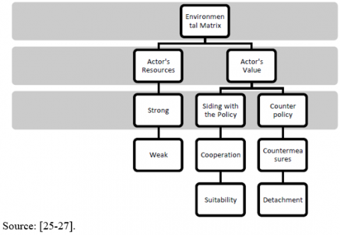
In conservation areas as shown in Figure 1, many parties are interested. According to Borrini-Feyerabend, parties with interest in conservation areas are people who live and reside in or around conservation areas, people who derive economic benefits from the resources contained in conservation areas, governments who are responsible for the preservation of conservation areas, NGOs with interest in the preservation of conservation areas, and so on. Each has different interests in conservation areas. The real form of support provided by the community is socialization and counseling activities held every week to manage forest resources. Activities Stakeholder maps all relevant stakeholders, including affected parties, government agencies, and other institutions such as NGOs with project activities, local media, religious and customary leaders, academics in relevant disciplines, and others. Including the initial direct involvement of stakeholders, then a focused meeting was held in Bandar Lampung, which was the beginning of uniting interests for stakeholders with the main objective of relating to National Parks and coffee farmers. The provincial government, the Director-General of the Ministry of Environment and National Park Management with partner NGOs expressed support for the implementation objectives of the meeting. Including the initial direct involvement of stakeholders, then a focused meeting was held in Bandar Lampung, which was the beginning of uniting interests for stakeholders with the main objective of relating to National Parks and coffee farmers. The provincial government, the Director-General of the Ministry of Environment and National Park Management with partner NGOs expressed support for the implementation objectives of the meeting. Including the initial direct involvement of stakeholders, then a focused meeting was held in Bandar Lampung, which was the beginning of uniting interests for stakeholders with the main objective of relating to National Parks and coffee farmers. The provincial government, the Director-General of the Ministry of Environment and National Park Management with partner NGOs expressed support for the implementation objectives of the meeting [25-27].
Figure 1. Types of environmental reactions to policy implementation
The research was conducted in Sukarga Village, Suoh, West Lampung, from 12 June to 25 August 2021. A desk review of relevant literature strengthens qualitative case study research. Data were collected by interview, observation, and documentation study. Interviews were conducted with 40 people, consisting of 10 people from the community, five from the village and district government, five from NGOs, and ten from NGOs, and the rest were interviews with the community from the management, observation, and production divisions.
The collected data is then reviewed through Marketing Analysis and Policy Implementation Environment Matrix developed. Marketing analysis can explain the extent to which the successful implementation of conservation village policies is seen from 3 processes that influence each other [13], namely:
Policy acceptance, when the community and other parties can understand the conservation village policy as the rules of the game to realize responsible, optimal, and sustainable forest management; On the other hand, the village government in this context also understands policy as a task must be carried out.
Adoption of policies, when the community and other parties can accept the policy rules of the game to realize responsible, optimal, and sustainable forest management; on the other hand, the village government in this context also accepts the policy as a task that must be implemented.
Preparedness strategy, when the community and other parties implement and become part of the conservation village policy; On the other hand, the local government is ready to be the implementer of the policy.
The developed policy implementation environment matrix is used to further analyze the effectiveness of policy implementation. The model divides the assessment of the effectiveness of policy implementation into four parts: the confluence of 2 main variables, namely: stakeholder approval of the content of the policy and two resources owned by stakeholders. The policy approval variable is divided into pro-policy and contra-policy variables. Meanwhile, the variable resources owned by stakeholders are divided into strong and weak. Based on the implementation typology, the opportunity to produce sustainable implementation performance is when it has environmental support, in this case, non-government stakeholders (communities and NGOs).
In the strategic environmental reaction matrix for implementation, there are two interrelated components; where the first component is related to actor resources which can then provide final analysis results related to resource activities used to carry out strong or weak tasks. Furthermore, the second component relates to actor values which will then be applied in implementation activities where this value will function to find out whether these actors agree on policies that will be carried out with the continuation of activities, namely cooperation where implementing actors agree with existing policies and then adjust according to the rules. That exists or, on the contrary, namely, the actors disagree, so that it continues with counter actions and detachment.
4.1 Results
4.1.1 Conservation Park at a glance
Bukit Barisan Selatan National Park is part of the Bukit Barisan mountains. The mountainous area of Bukit Barisan has a variety of natural vegetation such as mangrove forest vegetation, coastal forest, and lowland tropical forest. Bukit Barisan Selatan is one of three national parks in Sumatra, which received a prestigious award from UNESCO in 2004. TNBBS, together with Gunung Leuser National Park [TNGL] and Kerinci Seblat National Park [TNKS], has been named the Sumatran Tropical Rain Forest Heritage [TRHS]. Sumatran Tropical Rainforest World. Bukit Barisan Selatan National Park stretches from Bengkulu to Lampung. The area is about 355,511 hectares. Administratively, the area covers Tanggamus Regency [10,500 ha] and West Lampung Regency, as well as the West Coast covering an area of 280,300 hectares for Lampung, and in Kaur Regency, Bengkulu about 64,711 hectares. Initially, in 1935, TNBBS was a Wildlife Sanctuary established through the Van der Gouvernour-Generat Van Nederlandseh Indie Decree No. 48 stbl. 1935. Its name was South Sumatra I [SSI], covering 356,800 hectares. Territory, Reg. 49B Krui Barat, Reg. 46B Sekincau, Reg. 47B Bukit Penetoh, Reg. 22B Kubunicik, Reg. 49 SSI South, and Reg. 52 East Kaur. Furthermore, on October 14, 1982 the South Sumatra I Wildlife Reserve was designated as a TNBBS area through the Statement Letter (SP) of the Minister of Agriculture No. 736/Mentan/X/1982. Based on the Minister of Forestry Regulation No. P.03/Menhut-II/2007 dated February 1, 2007 concerning the Organization and Work Procedures of the National Park Technical Implementation Unit, the TNBBS Hall was designated as the TNBBS Hall. 711 hectares. Initially, in 1935, TNBBS was a Wildlife Sanctuary established through the Van der Gouvernour-Generat Van Nederlandseh Indie Decree No. 48 stbl. 1935. Its name was South Sumatra I [SSI] covering an area of 356,800 hectares. Territory, Reg. 49B Krui Barat, Reg. 46B Sekincau, Reg. 47B Bukit Penetoh, Reg. 22B Kubunicik, Reg. 49 SSI South, and Reg. 52 East Kaur. Furthermore, on October 14, 1982 the South Sumatra I Wildlife Reserve was designated as a TNBBS area through the Statement Letter (SP) of the Minister of Agriculture No. 736/Mentan/X/1982. Based on the Minister of Forestry Regulation No. P.03/Menhut-II/2007 dated February 1, 2007 concerning the Organization and Work Procedures of the National Park Technical Implementation Unit, the TNBBS Hall was designated as the TNBBS Hall. 711 hectares. Initially, in 1935, TNBBS was a Wildlife Sanctuary established through the Van der Gouvernour-Generat Van Nederlandseh Indie Decree No. 48 stbl. 1935. Its name was South Sumatra I [SSI] covering an area of 356,800 hectares. Territory, Reg. 49B Krui Barat, Reg. 46B Sekincau, Reg. 47B Bukit Penetoh, Reg. 22B Kubunicik, Reg. 49 SSI South, and Reg. 52 East Kaur. Furthermore, on October 14, 1982 the South Sumatra I Wildlife Reserve was designated as a TNBBS area through the Statement Letter (SP) of the Minister of Agriculture No. 736/Mentan/X/1982. Based on the Minister of Forestry Regulation No. P.03/Menhut-II/2007 dated February 1, 2007 concerning the Organization and Work Procedures of the National Park Technical Implementation Unit, the TNBBS Hall was designated as the TNBBS Hall. TNBBS is a Wildlife Sanctuary that was established through the Van der Gouvernour-Generat Van Nederlandseh Indie Decree No. 48 stbl. 1935. Its name was South Sumatra I [SSI] covering an area of 356,800 hectares. Territory, Reg. 49B Krui Barat, Reg. 46B Sekincau, Reg. 47B Bukit Penetoh, Reg. 22B Kubunicik, Reg. 49 SSI South, and Reg. 52 East Kaur. Furthermore, on October 14, 1982 the South Sumatra I Wildlife Reserve was designated as a TNBBS area through the Statement Letter (SP) of the Minister of Agriculture No. 736/Mentan/X/1982. Based on the Minister of Forestry Regulation No. P.03/Menhut-II/2007 dated February 1, 2007 concerning the Organization and Work Procedures of the National Park Technical Implementation Unit, the TNBBS Hall was designated as the TNBBS Hall. TNBBS is a Wildlife Sanctuary that was established through the Van der Gouvernour-Generat Van Nederlandseh Indie Decree No. 48 stbl. 1935. Its name was South Sumatra I [SSI] covering an area of 356,800 hectares. Territory, Reg. 49B Krui Barat, Reg. 46B Sekincau, Reg. 47B Bukit Penetoh, Reg. 22B Kubunicik, Reg. 49 SSI South, and Reg. 52 East Kaur. Furthermore, on October 14, 1982 the South Sumatra I Wildlife Reserve was designated as a TNBBS area through the Statement Letter (SP) of the Minister of Agriculture No. 736/Mentan/X/1982.
Based on the Minister of Forestry Regulation No. P.03/Menhut-II/2007 dated February 1, 2007 concerning the Organization and Work Procedures of the National Park Technical Implementation Unit, the TNBBS Hall was designated as the TNBBS Hall. South Sumatra I [SSI] covers an area of 356,800 hectares. Territory, Reg. 49B Krui Barat, Reg. 46B Sekincau, Reg. 47B Bukit Penetoh, Reg. 22B Kubunicik, Reg. 49 SSI South, and Reg. 52 East Kaur. Furthermore, on October 14, 1982 the South Sumatra I Wildlife Reserve was designated as a TNBBS area through the Statement Letter (SP) of the Minister of Agriculture No. 736/Mentan/X/1982. Based on the Minister of Forestry Regulation No. P.03/Menhut-II/2007 dated February 1, 2007 concerning the Organization and Work Procedures of the National Park Technical Implementation Unit, the TNBBS Hall was designated as the TNBBS Hall. South Sumatra I [SSI] covers an area of 356,800 hectares. Territory, Reg. 49B Krui Barat, Reg. 46B Sekincau, Reg. 47B Bukit Penetoh, Reg. 22B Kubunicik, Reg. 49 SSI South, and Reg. 52 East Kaur. Furthermore, on October 14, 1982 the South Sumatra I Wildlife Reserve was designated as a TNBBS area through the Statement Letter (SP) of the Minister of Agriculture No. 736/Mentan/X/1982. Based on the Minister of Forestry Regulation No. P.03/Menhut-II/2007 dated February 1, 2007 concerning the Organization and Work Procedures of the National Park Technical Implementation Unit, the TNBBS Hall was designated as the TNBBS Hall. On October 14, 1982, the South Sumatra I Wildlife Reserve was designated as a TNBBS area through the Statement Letter (SP) of the Minister of Agriculture No. 736/Mentan/X/1982. Based on the Minister of Forestry Regulation No. P. 03/Menhut-II/2007 dated February 1, 2007 regarding the Organization and Work Procedure of the National Park Technical Implementation Unit, the TNBBS Hall was designated as the TNBBS Hall. On October 14, 1982, the South Sumatra I Wildlife Reserve was designated as a TNBBS area through the Statement Letter (SP) of the Minister of Agriculture No. 736/Mentan/X/1982. Based on the Minister of Forestry Regulation No. P.03/Menhut-II/2007 dated February 1, 2007 concerning the Organization and Work Procedures of the National Park Technical Implementation Unit, the TNBBS Hall was designated as the TNBBS Hall. Various efforts have been made by the TNBBS Center in managing and maintaining the integrity of the national park area. The form of efforts made is adjusted to the direction and objectives of TNBBS management. Management of conservation areas in practice faces many challenges, namely external in the form of seizure of space and economic assets, encroachment, illegal logging, animal hunting, forest fires and internally in area management in the form of planning systems, stakeholder boundaries, leadership and management. Seeing from the many challenges experienced in managing this conservation area, the central/state party in providing permanent protection can be said to be effective because the protection provided by the state can directly solve the challenges in the internal management of the area, where all stakeholders will work together. the same based on existing rules in accordance with the concept of state protection for each conservation area,
Resolving forest area problems that have occurred and avoiding the occurrence of new problems in the future as well as increasing the management capacity of conservation and protected forests.
Facilitate access for beneficiaries or can reduce the occurrence of high cost economies and there is a strong basis for allocating forest benefits equitably.
Provide social and economic infrastructure for strengthening local institutions, especially those who have access to forest resources, increase economic efficiency and develop value added forest products.
These three activities are carried out and are oriented towards spatial planning as seen in Figure 2 by taking into account the local socio-economic situation and uniting the direction of implementing the activities of the Government, Provincial and Regency/City Governments and other stakeholders. Because of this, the Forest Management Unit can also be a strategic solution in forest management.
Then what is interesting about this national park? Apart from being the habitat of the Rafflesia arnoldii flower, this area is also the habitat of three endangered mammals. The Sumatran elephant [Elephas maximus sumatrensis], Sumatran tiger [Panthera tigris sumatrae], and Sumatran rhinoceros [Dicerorhinus sumatrensis] live here (Figure 3 and Figure 4). Especially for rhinos, in November 2005, rhino Rosa, who was four years old at the time, and now in the Sumatran Rhino Wildlife Sanctuary [SRS], Way Kambas National Park, Lampung, used to often go in and out of residential areas in TNBBS. Before being rescued, Rosa allegedly had wandered in the community area for a while.
Figure 2. South bukit barisan national park map
Figure 3. Key animal pictures
Figure 4. Rafflesia arnoldii flower
The Sumatran rhino is a rare two-horned animal. Based on IUCN Critical [Critically Endangered] status or one step towards extinction in the wild. Its existence is spread in Gunung Leuser National Park, South Bukit Barisan National Park, Way Kambas National Park, and West Kutai, East Kalimantan. The number is estimated to be no more than 100 individuals.
TNBBS has important value for the protection of several large mammals. There are at least 122 species of mammals, including six species that are threatened with extinction according to the IUCN Red Data Book, such as the Sumatran elephant (Elephas maximus sumatranus), Sumatran rhino (Dicerorhinus sumatrensis), Tapir (Tapirus indicus), Sumatran tiger (Panthera tigris sumatrae). sun bear (Helarcto malayanus), and ajag (Cuon alpinus); 123 species of herpetofauna (reptiles and amphibians including turtles); 53 types of fish; 221 species of insects and 450 species of birds, including nine types of hornbill. TNBBS is an Important Bird Area (DPB), with criteria A1. Endangered Birds and A2. Limited Distributed Birds. TNBBS is also one of the priority landscapes for Sumatran tiger habitat conservation. In addition, TNBBS is a habitat for various types of amazing flora. Besides having Rafflesia as the largest rare flower globally, there is also Amorphophallus as the tallest flower in the world. Other types of flora reach 514 species of trees and undergrowth, 126 species of orchids, 26 species of rattan, and 25 species of bamboo. In this case, the management of the diversity of flora and fauna found in the Bukit Barisan Selatan National Park has different programs, so the two priorities cause no significant impact on managing the wealth of flora and fauna and the landscape of the area in the Bukit Barisan Selatan National Park.
According to the Meteorology and Geophysics Agency (1973), based on the average annual rainfall, the TNBBS area can be grouped into two parts, namely the western part of the national park with moderately high rainfall ranging from 3000-3500 mm per year and the eastern part of the national park ranging from 2500 -3000mm per year. This difference is caused by the influence of the Bukit Barisan Selatan mountain range so that the eastern part is drier. The TNBBS area is the upstream part of the rivers that will lead to residential areas and agricultural areas downstream, so that it plays a very important role as a water catchment area and protection of the water system. Most of the existing rivers empties to the southwest and empties into the Indonesian Ocean while some empties into the Semangka Bay. The rivers that flow in the northern part of this national park consist of Air Nasal Kiri, Air Sambat, Air Nasal Kanan, Way Menula, Way Simpang and Way Laai. The rivers that flow in the central part of this national park consist of Way Tenumbang, Way Biha, Way Marang, Way Ngambur Bunuk, Way Tembuli, Way Ngaras, Way Pintau, Way Pemerihan, Way Semong, and Way Semangka. Meanwhile, in the southern part of the national park, there are Way Cangguk, Way Sanga, Way Menanga Kiri, Way Menanga Right, Way Paya, Way Genesis, Way Sulaeman and Way Blambangan. At the southern end of this national park there is a lake that is only separated by a tens of meters wide sand beach, namely Menjukut Lake (150 ha). In the central part, namely in the Suoh area, there are 4 (four) adjacent lakes, namely Asam Lake (160 ha), Lebar Lake (60 ha), Oil Lake (10 ha), and Belibis Lake (3 ha). While the southeast, south and west of the national park are surrounded by oceans, namely the waters of Semangka Bay, Tanjung China and the Indonesian Ocean.
The Bukit Barisan Selatan National Park area generally has a complete landscape ranging from an altitude of 0 m above sea level to 1,964 m above sea level. The natural ecosystem that stretches in this area represents the vegetation type of mangrove forest, coastal forest, and tropical lowland forest to the mountainous debt of Sumatra. This TNBBS area is the largest remaining lowland forest on the island of Sumatra and has a complete and the same unbroken type of ecosystem, including marine and terrestrial ecosystems. Namely, coastal forest (1%), rain forest (45%), hill rain forest (34%), lower mountain rain forest (17%), high mountain rain forest (3%), mangrove ecosystem, swamp ecosystem, and estuaries. Such forest cover, apart from the various diversity of flora and fauna that exist in the Bukit Barisan Selatan National Park, has backfired on the existing ecosystem and vegetation caused by human activities (especially encroachment and illegal logging) is having damaged as in Figure 5 and 6. The damage is characterized by changes in vegetation cover to vegetation cover that is not the same as it should be. Since the TNBBS area is a representative protected area for lowland and mountainous rain forests, naturally TNBBS area has initially been a forest. The damage is characterized by changes in vegetation cover to vegetation cover that is not the same as it should be. Since the TNBBS area is a representative protected area for lowland and mountainous rain forests, naturally TNBBS area has initially been a forest. The damage is characterized by changes in vegetation cover to vegetation cover that is not the same as it should be. Since the TNBBS area is a representative protected area for lowland and mountainous rain forests, naturally TNBBS area has initially been a forest.
Figure 5. Image of encroachment and illegal logging
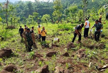
Figure 6. Green activities
However, some of the vegetation has now become a secondary forest, shrubs, shrubs, coffee plantations, and even some of it is in the form of open land with no vegetation, resulting in a decrease in biodiversity and habitat functions as well as protection functions. Evolutionarily, vegetation that has undergone these changes through a succession process will gradually recover. However, this process takes quite a long time, and it is even feared that the succession process will create a new balance that is not per the original conditions. This is because changes in vegetation occur due to human intervention, which tends to increase. Even though the damage needs to be repaired immediately, considering that TNBBS functions as a conservation area for living natural resources and their ecosystems and serves as a protected area for downstream areas. Therefore, ecosystem restoration is an important activity that needs to be prioritized. Therefore, an agreement was born on a conservation area, better known as the Pekon Conservation Agreement, which aims to secure the remaining forest and reduce pressure on the Bukit Barisan Selatan National Park area through optimizing land management and sustainable village development. Recovery activities consist of rehabilitation/restoration, participatory observation, and improvement of the community's economy. Ecosystem rehabilitation is an action to restore ecosystems that have damaged their functions in the form of reduced land cover with the aim of achieving a balance of living natural resources and their ecosystems close to their original condition. Ecosystem restoration is an act of restoring function damage in the form of land cover through planting, habitat, and population development with the aim of achieving a balance of biological natural resources and their ecosystems that are close to their original condition. At the same time, participatory observation activities include joint observation activities, which will later become media to build awareness of forest areas, and observations made to see the potential that exists in forest areas that can be utilized economically by the community (especially non-timber forest products). And for economic improvement activities surrounding communities related to the production of superior products and savings and loan cooperatives. Development of habitats and populations to achieve a balance of living natural resources and their ecosystems that are close to their original conditions. At the same time, participatory observation activities include joint observation activities, which will later become media to build awareness of forest areas, and observations made to see the potential that exists in forest areas that can be utilized economically by the community (especially non-timber forest products). And for economic improvement activities surrounding communities related to the production of superior products and savings and loan cooperatives. Development of habitats and populations to achieve a balance of living natural resources and their ecosystems that are close to their original conditions. At the same time, the participatory observation activities include joint observation activities, which will later become media to build awareness of forest areas, and observations made to see the potential that exists in forest areas that can be utilized economically by the community (especially non-timber forest products). Superior products and savings and loan cooperative businesses. Joint observation activities, which will later become media to build awareness of forest areas, and observations are carried out to see the potential that exists in forest areas that can be utilized economically by the community (especially non-timber forest products). And for activities to increase the surrounding community's economy related to the production of superior products and the savings and loan cooperative business. Joint observation activities, which will later become media to build awareness of forest areas, and observations are carried out to see the potential that exists in forest areas that can be utilized economically by the community (especially non-timber forest products). And for activities to increase the surrounding community's economy related to the production of superior products and the savings and loan cooperative business.
4.1.2 Conservation village marketing policy
Figures 7-9 show the implementation of conservation village policies is the right thing to be able to increase public awareness in saving forests from various threats. The conservation village is also the answer to various community problems around the Bukit Barisan Selatan National Park. They always experience issues related to human-animal conflicts, forest management, land disputes, and economic development. The actual manifestation of the things above can be seen in the existing program of activities in the implementation of this conservation village. These activities include restoration/rehabilitation, observation, and improvement of the community's economy in the innovation of superior products and forest resources that did not have a previous value to have a high selling value. In this study, based on the details of the three activities above, this policy has been effective and is said to be successful at the level of effectiveness. This is because the implementing actors, namely the village government, NGOs, and the community, have understood the context of the conservation village policy as a rule for realizing participation, community welfare, and environmental sustainability as well as being realized in increasing the involvement of the Sukarga village community. Regularly. This can be seen from the regularity of discussion and socialization activities carried out jointly by each stakeholder in implementing this conservation village. In addition to regular discussions as an indication of stakeholders' acceptance of good policies, this activity takes place in the formation of collective agreements on the implementation of conservation village policies. This is a rule that every society must obey adequately. This agreement was made based on several points that adjust the topography and current community conditions that have not been included in the implementation of conservation villages so that together with the stakeholders set this rule as a general and technical guideline for the implementation of a conservation village, this rule is called a village conservation agreement.
Figure 7. Observation activities
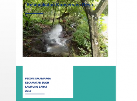
Figure 8. Draft of the Pekon conservation agreement
Figure 9 Damar forest product harvesting activities
After the determination, the stakeholders in the implementation of the conservation village formed a task force in the conservation village by dividing it into two different types of groups. This is done because the management of forest products can be managed effectively and efficiently. The two groups were divided into female and male groups. The women's group focuses more on coffee, cocoa, and fruit forest products. In contrast, the men's group focuses more on agricultural forest products and timber and non-timber forest products that must be obtained from the forest first.
4.2 Discussion
Policy implementation does not exist in a vacuum, involving many stakeholders, including non-government actors who interact in the implementation process. Kiviniemi's [27] describes public policies that lead to government actions supported by two things, namely the resources owned by the government and the values to be achieved, do not exist in a vacuum, but the environmental influence factor, in this case, is non-existent. - government actors exert influence on the implementation process.
The implementation of the conservation village policy must demonstrate the effectiveness of its implementation. The policy implementation environment matrix developed by Kiviniemi analyzes the implementation choice model's effectiveness; cooperation, conformity, counter-action, and detachment must be chosen and built wisely per the objectives of the conservation village policy. By using a typology, the successful implementation of conservation village policies needs to get support from government stakeholders so that the type of implementation that results is Cooperation, Conformity.
Bevir, with the wave of democratization, implementation studies cannot be separated from the idea of adopting a democratic governance approach to explain failures and successes [28]. Putra, in the perspective of a democratic government approach, successful implementation goes through 2 stages: participation/environmental support, namely not only the community but also NGOs. Next is the implementation towards the goal. How high is the level of community participation in designing programs. It is assumed that if the activities designed are aspirational and beneficial for the wider community, they are considered successful. Thus the program they designed was implemented well to achieve the goal [29].
Using the analysis of environmental reactions to policy implementation developed by Kiviniemi [27] helps to demonstrate the success and effectiveness of its implementation. The effectiveness of the conservation village policy implementation is carried out by two changes to the framework, namely through the framework of building an agreement on the content of the policy and the resources owned by the stakeholders.
The success of implementing a conservation village cannot be separated from the value and support of resources owned by each stakeholder in carrying out this program, as loaded in Table 1. This program aims to secure the remaining forest and reduce pressure in the Bukit Barisan Selatan National Park area through optimizing land management and sustainable village development. The application of the Conservation Village Model in saving the Tropical Rain Forest in TNBBS can reduce human activities such as hunting outside and illegal land clearing in forest areas that can threaten the ecosystem. Pekon conservation is part of the Bestari program which is a collaboration between the Bukit Barisan Selatan National Park Center (BBTNBBS) with WCS, WWF-Indonesia, and YABI, which aims to conserve priority habitats in the Bukit Barisan Selatan National Park-TNBBS (Conserving priority habitats). in Bukit Barisan Selatan National Park, Sumatra). This program is part of the International Climate Initiative (IKI) funding scheme of the Federal Ministry for the Environment, Nature Conservation, and Nuclear Security (BMU) which is channeled through KFW (German Development Bank) S. One of the outputs of this program is to reduce pressure on the Intensive area. Protection Zone (IPZ) TNBBS through capacity building and community involvement in ecosystem restoration and land use management in surrounding villages. and Nuclear Security (BMU) channeled through KFW (German Development Bank) S. One of the outputs of this program is to reduce pressure on the Intensive Protection Zone (IPZ) area - TNBBS through capacity building and community involvement in ecosystem restoration and land use management in surrounding villages. and Nuclear Security (BMU) channeled through KFW (German Development Bank) S. One of the outputs of this program is reducing pressure on the Intensive Protection Zone (IPZ) – TNBBS through capacity building and community involvement in ecosystem restoration and land use management. in the surrounding villages.
The values and supporting resources are then mapped by the author using marketing policy analysis and environmental reaction matrix, which can then explain the successful implementation of conservation village policies in terms of three mutually influencing processes [13], namely:
Acceptance of the policy, in this section, the stakeholders (NGOs and the community) have understood the context of the conservation village policy as a rule for realizing participation, community welfare, and environmental sustainability, which is manifested in increasing the participation of the Sukarga village community on a regular basis. Socialization is related to the points of agreement in the village community. Conservation includes forest governance, natural resource utilization management, and others.
Policy adoption, where stakeholders, especially communities directly adjacent to TNBBS, have accepted this conservation village policy as a rule that the village government then sets in a concrete and proper manner in the official village regulation.
Policy readiness, the stakeholders, especially the community, have positioned themselves as an important part of policy implementation at this stage. This was later manifested in forming a conservation village task force with the same goal but a different object. This task force is divided into a women's group that focuses on coffee forest products and a men's group that focuses on agriculture. And management of timber and non-timber forest products. Wood and the use of forest products that are not useful into something that is useful and has a selling value.
4.3 Typology of Environmental Reaction to Policy Implementation
The application of the conservation village model in TNBBS seen from the analysis of the ideal type of environmental reaction shows the results of mutual cooperation or support. This can be seen through the implementation of program activities where the community is always enthusiastic and punctual in participating in socialization activities, counseling, and direct practice in the field, which is illustrated in Tables 2 and 3.
Table 1. Marketing policy implementation
|
Stakeholders |
Policy acceptance |
Adopt policy |
Readiness Strategy |
|
village government |
Activity socialization |
Planning with the community |
serve the strengths, weaknesses, opportunities and potential threats |
|
NGO |
Community empowerment Community |
Capacity building through training in seedling and planting techniques. |
Joint observation can be a medium to build forest area awareness |
|
Public |
Activity socialization |
Observations to see the potential that exists in forest areas that can be used economically by the community (especially non-timber forest products) |
Growing crops that function in a conservation, economic and social way |
Source: Interview and Observation, 2021
Table 2. Ideal type of environmental reaction to Pekon conservation
|
Resources of actors |
Value of actors |
|
|
|
Pro-Policy |
Counter Policy |
|
Strong |
NGOs, Community and Village Government |
Counter Action |
|
Weak |
Suitability |
Detachment |
Table 3. Cooperation environment
|
No |
Activity Description |
Sukaramaga Village |
|
1 |
Activity Socialization |
+ |
|
2 |
Planning with the community |
+ |
|
3 |
Growing crops that function in a conservation, economic and social way |
+ |
|
4 |
Community capacity building through nursery and plant technique training |
+ |
|
5 |
Application and regulation of cropping patterns from short-term crops to long-term crops |
+ |
|
6 |
Determination of CCP into Village Regulation |
+ |
|
7 |
Intercropping (low, medium, tall plants) |
+ |
Source: Interview and Observation, 2021
For example, the process of implementing reforestation activities consists of 7 actions, as listed in Table 3. In the table above, the Sukarga Community responded positively that all actions from the implementation of the conservation village were well received. In addition, the resources owned by stakeholders are channeled appropriately per mutually agreed guidelines so that reforestation activities can run according to the concept of village conservation agreements. This can be seen from the community's level of community participation and the level of capacity slowly starting to show significant changes. In fact, small business groups have started to form around the area with the theme of using local products that are not useful to be useful and the village government in spatial planning areas that are starting to be systematic by paying attention to conservation elements in the plan, for example, regulations related to area management for locations businesses that should not be too close to the conservation area for fear of inadvertently damaging the biodiversity contained and prohibiting the erection of permanent buildings around the area. This is because the area directly adjacent to TNBBS is an area surrounded by fire paths, so it is feared that one day the magma in the ground will suddenly explode. Then in the Participatory Observation activity, the second activity of the Pekon Conservation Agreement program is participatory observation. Regarding area management for business locations, regulations should not be too close to conservation areas for fear of inadvertently damaging the biodiversity contained and prohibiting the erection of permanent buildings around the area. This is because the area directly adjacent to TNBBS is an area surrounded by fire paths, so it is feared that one day the magma in the ground will suddenly explode. Then in the Participatory Observation activity, the second Pekon Conservation Agreement program activity is participatory observation. Regarding area management for business locations, regulations should not be too close to conservation areas for fear of inadvertently damaging the biodiversity contained and prohibiting the erection of permanent buildings around the area. This is because the area directly adjacent to TNBBS is an area surrounded by fire paths, so it is feared that one day the magma in the ground will suddenly explode. Then in the Participatory Observation activity, the second Pekon Conservation Agreement program activity is participatory observation.
The evaluation results of participatory observation activities and indicators of participatory observation are generally responded positively by the community around TNBBS. This is shown through the community's attitude, which always helps stakeholders in carrying out these conservation activities at any time, even the community. And the village government also often conducts Focus Group Discussions and shares related strengths, weaknesses, opportunities, and potential threats that exist if they are directly adjacent to TNBBS. Then the income increase activities were also responded to very positively by the people who are directly adjacent to TNBBS. This is indicated by the increased creativity of housewives who initially created a 0% savings and loan cooperative, and the interest payments were then not used by the cooperative but returned to members so that the people who participated did not feel overwhelmed and had an emergency container when they needed quick money. After the existence of the CCP in an effort to save the forest directly adjacent to TNBBS, they began to recognize good product marketing strategies and how to distribute them effectively and efficiently.
In addition, the support of resources from every stakeholder in the implementation of this conservation village plays a very important role in its successful implementation of the conservation village [26]. Actor resource support is provided by providing facilities, budget funds, and infrastructure for the socialization of policies, programs and activities, outreach activities, and field schools for the community. These activities include 1) Reforestation/Rehabilitation includes Counseling and socialization of river border conservation and river flow, Restoration with wood plants (forest restoration), Restoration in TNBBS, especially in former encroached areas, 2) Participatory Observations include: Re-discussion of tourism management between ecotourism and National Park management permit holders, planting 20 timber trees in gardens in National Parks, improve vanilla, cocoa, and rice cultivation skills; 3) Increasing Community Income includes: Development of post-harvest business for agricultural commodities such as cocoa, vanilla, and rice, Training on Plant Disease Pest Control, Plant Pest Control Field Schools, Reducing the use of hazardous/toxic/inorganic materials and starting to use organic materials in cultivation practices [25]. In addition, resource support and policy acceptance are very important for implementing conservation village activities. This is because conservation parks can increase community access, the role and function of national parks for sustainability and community welfare. Plant Disease Pest Control Training, Plant Pest Control Field Schools, Reducing the use of hazardous/toxic/inorganic materials and starting to use organic materials in cultivation practices. In addition, resource support and policy acceptance are very important for implementing conservation village activities. This is because conservation parks can increase community access, the role and function of national parks for sustainability and community welfare. Plant Disease Pest Control Training, Plant Pest Control Field Schools, Reducing the use of hazardous/toxic/inorganic materials and starting to use organic materials in cultivation practices. In addition, resource support and policy acceptance are very important for implementing conservation village activities. This is because conservation parks can increase community access, the role and function of national parks for sustainability and community welfare [30].
Figure 10 is a map depicting 4 locations for the implementation of the Pekon Conservation Agreement Program in Bukit Barisan Selatan National Park. Then, at the implementation stage of the conservation village, there are other activities besides technical matters, such as reforestation and observation of vegetation in the forest. Another form of action from the conservation village section to save tropical rain forests is resource support in the form of the Formation of Community Movements and Partnerships to create appropriate strategies and concept maps to protect natural resources from upstream to downstream by connecting various rules that have been set. Determined by the central or regional government [30]. This is motivated by the increasingly complex problem of damage to watersheds (DAS) in Indonesia, where there is a conflict of interest between the upstream, middle and downstream areas. It should be understood that the watershed boundary is different from the administrative boundary, so it is often forgotten that community activities in the upstream village/regency/regency administration area significantly affect the downstream administrative area. Upstream, mining (quarrying, coal mining), palm oil waste, logging, etc. will have an impact on environmental problems downstream, such as river silting, which causes flooding, closure of irrigation entrances by sedimentation, water pollution, sedimentation in reservoirs, so that reservoir life is reduced, and so on. Because of that, an integrated watershed management effort that involves the community and stakeholders is needed to manage the watershed properly. Downstream areas provide incentives to upstream areas to support forest conservation efforts. Many efforts can be made to carry out watershed conservation, including; reforestation, forest conservation, saving water with infiltration wells, biopori (downstream area), upstream Micro Hydro Power Plant (PLTHM) so those upstream communities can empower the economy of forest village communities (MDH), which in turn MDH cares about the preservation of source water, which can be seen in Figure 11.
The role of the watershed (river flow) is vital in human life. Disturbed river areas will certainly threaten human life. Remember, damaged watersheds can cause disasters such as droughts, floods, and landslides. Therefore, we really have to provide an understanding to the broader community about the importance of integrated watershed management. The small steps taken by the actors in this conservation area are in the protected area or upstream of the actors and stakeholders. Building sustainable protected areas by monitoring forest reforestation regularly, increasing the role of women in agricultural forest communities, and enforcing concrete laws. In buffer or central areas, water distribution areas, strengthening rural reforestation and revitalizing lakes, reservoirs, water construction, urban drainage, and zero waste [3R]. Then in the downstream cultivation area, permanent rice fields are determined where there is no permanent building construction because it will damage the mass and fertility of the soil. In addition, there is also a river arrangement of rivers and infiltration wells as well as environmentally friendly industries. And in river areas or coastal estuaries, conservation of rivers and coral reefs is carried out. Watershed management is very important for the balance of water and land ecosystems. Good or bad natural resources will depend on the quality of the watershed, from upstream to downstream. Weak watershed management can be seen in the occurrence of landslides, floods, and prolonged droughts. However, Watershed management technology must be accepted in various places by considering the balance of the ecosystem or with the principles of green ecology so that watershed management runs rationally and sustainably. Watershed management must be carried out before there is a decrease in the quantity and quality of water due to water withdrawal and water pollution by humans.
Figure 10. Pekon conservation agreement map
Figure 11. Water resources distribution map
This research is important because the implementation of conservation villages through the analysis of environmental marketing and income policies is an innovation in assessing forest conservation through the perspective of how it can be well received and understood [31]. Conservation villages can also improve community access, roles, and functions with national parks for community sustainability and welfare. And tools that can be used to save critical forest degradation and help the economic life of communities around buffer zones. Therefore, the main aspect of the successful implementation of this conservation village is the value/support of stakeholders and the resources that are owned to be able to run this conservation village precisely and adequately per the mutually agreed plan [32].
This village conservation model can save tropical rainforests in TNBBS.
The condition that the success of this village conservation model goes through several stages, namely first, the importance of paying attention to the type of community and the cultural values of the local community, because the success of the conservation village around the forest is primarily determined by the community's acceptance of the program and there will be increased participation in program implementation so that in its implementation program can run effectively and efficiently. Second, government support through policymaking can help strengthen the implementation of conservation policies to save tropical rain forests in TNBBS. And third, the effectiveness of the conservation village model in efforts to save tropical rain forests can be accelerated by the existence of training programs, group strengthening, understanding of community empowerment, facilitator capacity, mentoring processes, networks, and partnerships, the proportion of empowerment activities according to local conditions and needs, as well as monitoring and evaluations are carried out on an ongoing basis.
Thus, the implementation of the Conservation Pekon in Tropical Rain Forests in TNBBS has had a positive impact on the vegetation, which has begun to vary again, which previously had experienced a decline in the diversity of vegetation and flora and fauna. In addition, the implementation of Pekon Conservation can also reduce community dependence on forests, thereby reducing the threat of exploitation of human resources and reducing degraded land in watersheds [DAS].
We would like to thank all those who have contributed to this research, in particular to the Bukit Barisan Selatan National Park and the informants and the Sukamarga Community who are very participatory and innovative.
[1] Repetto, R. (1991). Incentives for Sustainable Forest Management. In G. Woodwell (Ed.), the Earth in Transition: Patterns and Processes of Biotic Impoverishment, 239-256. Cambridge: Cambridge University. https://doi.org/10.1017/CBO9780511529917.014
[2] O'Brien, T.G., Kinnaird, M.F. (1996). Birds and mammals of the Bukit Barisan Selatan National Park, Sumatra, Indonesia. Oryx, 30(3): 207-217. http://doi.org/10.1017/S0030605300021657
[3] Herawati, T. (2010). Comparison of community forest and community forest policies in property rights theory perspective. In the Proceedings of the National Seminar on MAPEKI (Indonesian Wood Research Society) XIII. https://doi.org/10.13140/2.1
[4] Moeliono, M. (2007). Hands off, hands on: Communities and the management of national parks in Indonesia. In N. S. Sodhi, G. Acciaioli, M. Erb, & A. Khee-Jin Tan (Eds.), Biodiversity and Human Livelihoods in Protected Areas: Case Studies from the Malay Archipelago, 165-186 Cambridge: Cambridge University. http://doi.org/10.1017/CBO9780511542169.013
[5] Kunzmann, K. (2008). The non-legally binding instrument on sustainable management of all types of forests - towards a legal regime for sustainable forest management? German Law Journal, 9(8): 981-1006. https://doi.org/10.1017/S2071832200000250
[6] Goodland, R., Asibey, E., Post, J., Dyson, M. (1990). Tropical moist forest management: The urgency of transition to sustainability. Environmental Conservation, 17(4): 303-318. https://doi.org/10.1017/S0376892900032756
[7] Katila, P., Pierce Colfer, C., De Jong, W., Galloway, G., Pacheco, P., Winkel, G. (Eds.). (2019). Sustainable Development Goals: Their Impacts on Forests and People. https://doi.org/10.1017/9781108765015
[8] Tegner Anker, H., Egelund Olsen, B. (Eds.). (2018). Sustainable Management of Natural Resources: Legal Instruments and Approaches. Intersentia. http://doi.org/10.1017/9781780687834
[9] Hodge, I. (2016). Protected areas: The example of National Parks. In The Governance of the Countryside: Property, Planning and Policy, 163-180. http://doi.org/10.1017/CBO9780511980237.009
[10] Nyhus, P.J., Sumianto, Tilson, R. (2003). Wildlife knowledge among migrants in southern Sumatra, Indonesia: Implications for conservation. Environmental Conservation, 30(2): 192-199. http://doi.org/10.1017/S0376892903000183
[11] Lynch, D. (2009). Sustainable Natural Resource Management: For Scientists and Engineers. http://doi.org/10.1017/CBO9780511816222
[12] Börner, J., Schulz, D., Wunder, S., Pfaff, A. (2020). The effectiveness of forest conservation policies and programs. Annual Review of Resource Economics, 12: 45-64. https://doi.org/10.1146/annurev-resource-110119-025703
[13] Febryano, I.G., Supono, Damai, A.A., Hardian, D., Winarno, G.D., Tresiana, N. (2021). Cantrang: A dilemma in policy implementation (case in lampung bay, indonesia). Problemy Ekorozwoju, 16(1): 133-142. https://doi.org/10.35784/pe.2021.1.14
[14] Fariani, A., Warly, L., Ichinohe, T., Fujihara, T. (1998). In vitro rumen degradation of legumes in south Sumatra, Indonesia. BSAP Occasional Publication, 22: 241-243. http://doi.org/10.1017/S0263967X00032730
[15] Gordon, D.J. (2020). Cities on the World Stage: The Politics of Global Urban Climate Governance. Cambridge: University of Cambridge Press. https://doi.org/ 10.1017/9781108125888
[16] Tarantika, W., Poniman, A., Martha, S. (2021). Preliminary analysis of deforestation using the forest canopy density (FCD) approach in support of defending the Indonesian State. Sensing Technology, 3(1). http://doi.org/139.255.245.7/index.php/TP/article/view/743
[17] Hotimah, O., Wirutomo, P., Alikodra, H.S. (2015). Conservation of world heritage botanical gardens in an environmentally friendly city. Procedia Environmental Science, 28: 453-463. https://doi.org.187802961500 2674
[18] Allo, M., Loureiro, M.L. (2013). Estimating a meta-damage regression model for a large accidental oil spill. Ecological Economics, 86: 167-175. https://doi.org/10.1016/j.ecolecon.2012.11.007
[19] Sheperd, C.R. (2011). Observations on trade in laughingthrushes (Garrulax spp.) in North Sumatra, Indonesia. Bird Conservation International, 21(1): 86-91. http://doi.org/10.1017/S0959270910000274
[20] Trudgill, S. (2021) Why Conserve Nature? Perspectives on Meaning and Motivation. Cambridge: Cambridge University Press, Ecology, Biodiversity and Conservation. https://www.cambridge.org.
[21] Oldfield, F. (2005). Environmental Change: Key Issues and Alternative Perspectives. https://doi.org/10.1017/CBO9781139165266
[22] Skonhoft, A., Solstad, J.T. (1996). Wildlife management, illegal hunting and conflicts. A bioeconomic analysis. Environment and Development Economics, 1(2): 165-181. http://doi.org/10.1017/S1355770X00000577
[23] Stolle, F., Lambin, E.F. (2003). Interprovincial and interannual differences in the causes of land-use fires in Sumatra, Indonesia. Environmental Conservation, 30(4): 375-387. http://doi.org/10.1017/S0376892903000390
[24] O'Toole, Jr, L., Meier, K. (2011). Public Management: Organizations, Governance, and Performance. Cambridge: Cambridge University Press. http://doi.org/10.1017/CBO9780511784040
[25] Hupe, P., Hill, M., Nangia, M. (2014). Studying implementation beyond deficit analysis: The top-down view reconsidered. Public Policy and Administration, 29(2): 145-163. https://doi.org/10.1177/0952076713517520
[26] Howlett, M. (2018). The criteria for effective policy design: character and context in policy instrument choice. Journal of Asian Public Policy, 11(3): 245-266. https://doi.org/10.1080/17516234.2017.1412284
[27] Hensengerth, O., Lu Y.Y. (2019). Emerging environmental Multi-Level Governance in China? Environmental protests, public participation and local institution-building. Public Policy and Administration Journal, 34(2): 121-143. https://doi.org/10.1177%2F0952076717753279
[28] Nyhus, P.J., Tilson, R. (2004). Characterizing human-tiger conflict in Sumatra, Indonesia: Implications for conservation. Oryx, 38(1): 68-74. http://doi.org/10.1017/S0030605304000110
[29] Jordan, A., Wurzel, R.K.W., Zito, A.R. (2006). Policy instrument innovation in the European Union: A realistic model for international environmental governance? In G. Winter (Ed.), Multilevel Governance of Global Environmental Change: Perspectives from Science, Sociology and the Law, 470-492. http://doi.org/10.1017/CBO9780511720888.020
[30] Gathrone-Hardy, F., Syaukani, Eggleton, P. (2001). The effects of altitude and rainfall on the composition of the termites (Isoptera) of the Leuser Ecosystem (Sumatra, Indonesia). Journal of Tropical Ecology, 17(3): 379-393. http://doi.org/10.1017/S0266467401001262
[31] Hysing, E. (2020). Designing collaborative governance that is fit for purpose: Theorising policy support and voluntary action for road safety in Sweden. Journal of Public Policy, 1-23. https://doi.org/10.1017/S0143814X2000029X
[32] Newig, J., Koontz, T.M. (2014). Multi-level governance, policy implementation and participation: The EU’s mandated participatory planning approach to implementing environmental policy. Journal of European Public Policy, 21(2): 248-267. https://doi.org/10.1080/13501763.2013.834070