Rahmat Safe’i* | Irlan Rahmat Maulana | Ferdi Ardiansyah | Irwan Sukri Banuwa | Sugeng Prayitno Harianto | Slamet Budi Yuwono | Yeni Apriliyani
© 2022 IIETA. This article is published by IIETA and is licensed under the CC BY 4.0 license (http://creativecommons.org/licenses/by/4.0/).
OPEN ACCESS
Mangrove forests must have health conditions to maintain forest functions and ensure benefits for the community's welfare and living creatures around them. Based on this, an evaluation of the health situation of the woodland is essential to ensure that the health situation of the mangrove forests is maintained. This research was conducted to assess and obtain data and information on the health of mangrove forests withinside the coastal regions of the East Lampung Regency. The levels on this look have been figuring out the measurement plot, making the forest health measurement plot, collecting data, identifying tree health, and analyzing forest health data. The results of the research that have been carried out show that of the 8 cluster plots that have been made, it was found that the dominant types of damage were open wounds, damaged leaves, shoots, and shoots, as well as broken/dead branches. Then, the locations of most damage were found in sprouts and shoots, branches, lower stems, leaves, and the tops and bottoms of stems. The average forest health condition within the coastal location of East Lampung Regency is within the medium class with a median NKH fee of 5,29. This indicates that the mangrove forests are correctly applied and controlled via way of the encompassing communities, especially those who depend on these mangrove forests. So far, the government and the community have worked together to conserve mangrove forests.
damage status value, forest health monitoring; mangrove forest
Mangrove forests are coastal area that is of value to various forest users and land developers. According to Kordi and Ghufran [1], the ecological functions of mangrove forests are to prevent erosion and coastal damage, prevent sea air intrusion into the land, maintain the stability of the soil layer, consider the impact of waves and waves, and reduce the strength of the wind when it reaches the mangrove ecosystem. Another function of the mangrove forest is as a food provider, a breeding ground for marine biota, a home for marine animals, and a place for foraging for various commercial and juvenile reef fish [2]. Meanwhile, the economic function of a mangrove forest is the monetary value of the wood and the living things in it. This is because mangroves can be used for various living needs of the population, such as news logs, buildings, charcoal, and medicines [3]. Mangroves play an important position in sustainability and support human livelihoods extensively used to supply food, wood, fuel, and medicines [4]. Mangroves also have an ecological function: sediment catcher, wave breaker, carbon storage, and carbon storage [5]. The interaction pattern between land, water, and other natural resources in mangrove forests refers to the management process between stakeholders through resources, formulation of new rules, and determination of actions [6]. Therefore, the management of natural resources, water, fisheries, and forests is essential. Moreover, this is more visible in the coastal zone, where access to and management of the resources used by the community is a livelihood in rural areas [7].
The local community uses one area with a large enough mangrove forest and an economical source in Lampung Province in the Coastal area of East Lampung Regency. The mangrove forest in this village is dominated by the white fire-fire mangrove (Avicennia marina) [8]. East Lampung Regency Mangrove Forest is a protected forest managed by the local government and local groups managing mangrove forests. Most of the people make a living as fishermen. In East Lampung Regency, shrimp paste processing groups, fish processing groups, farmer groups, and mangrove groups [9]. In addition, there is also the Maritime Love Women Group which carries out the utilization and processing of mangrove forest products [10]. East Lampung Regency has natural potential in mangrove forests which are currently being developed as ecotourism areas [11]. Mangrove forests in Lampung are located along 896 km of the total beach length of 1,105 km [6]. However, communities around mangrove forests have community concerns that if there is no mangrove forest, it can threaten their children and grandchildren from seawater abrasion, which can strike at any time, besides the degradation of mangrove forests in East Lampung Regency due to land conversion can threaten the existence of mangrove forests there [12], this happens because people do not know the proper technique in measuring the condition of forest damage.
The forest formation on the coast of East Lampung Regency is dominated by mangrove vegetation. With the mangrove forest formation, the coastal area will be protected from the damage that occurs, both coastal abrasion, seawater intrusion, and so on, so that economic activity can run well. Although necessary, the mangrove forest in the Coastal area of East Lampung continues to decline. Based on previous research by [13], changes in mangrove cover in Labuhan Maringgai in the period 1973-2013 resulted in the appearance of mangrove forest cover in an average interval of 10 years decreased by 11.82%. Weather change (growing sea levels and changing rainfall) and human sports (city improvement, aquaculture, mining, and over-exploitation of timber, fish, crustaceans, and shellfish) are essential threats to mangrove habitats [14, 15]. Lowering mangrove cover affects carbon stock and lack of deposits [16]. The large number of uses made by the community in the mangrove forest requires efforts to preserve the mangrove forest to prevent damage to the mangrove forest. One way to maintain the function and role of mangrove forests and their sustainability is to pay attention to the health of mangrove forests.
Forest health management is an effort to integrate knowledge about ecosystems, dynamics, and genetics of disturbing organisms with economic considerations so that the risk of damage is below the threshold of loss [17]. Facts at the health condition of woodland ecosystems in several countries have emerged as a purpose in sustainable forest control [18]. Forest health may be used as an indicator of sustainable woodland management [19]. Woodland health tracking is accomplished to assume worries that climate alternate should purpose new varieties of damage that were in no way formerly found [20]. This problem makes woodland health tracking critical to be carried out in diverse forests, considered one of that is mangrove forests. This activity is also needed to obtain information and records associated with the health of mangrove forests withinside the coastal location of East Lampung, and this will allow the community across the mangrove wooded area location to make optimal use of it by paying attention to the health circumstance of the mangrove wooded area.
2.1 Time and location of research
The implementation of this research began in September 2020 in the coastal mangrove forest area of East Lampung Regency (which is in the Labuhan Maringgai, Pasir Sakti, and Way Kambas National Park (TNWK) sub-districts).
2.2 Tool and materials
The tools used consisted of a tally sheet forest health, tree labels, tape meters (50 m), magic card (scale card density and tree canopy transparency), meter tape, Global Positioning System, binoculars, and cameras. The object of this research is the coastal mangrove forest area of East Lampung Regency, Labuhan Maringgai District, Pasir Sakti District, and TNWK.
2.3 Methods
Identification of mangrove woodland health is decided through measuring the tree damage index (IK). Measurement of the IK of mangrove timber is obtained through the Forest Health Monitoring (FHM) method. The FHM device is expected to explain changes in woodland conditions that arise at particular instances to deal with woodland health problems, which affect wooded area surroundings sustainability [21]. The ecological indicator used in forest health assessments is vitality by observing tree damage and crown condition [22]. The number of FHM cluster plots made were 10 FHM clusters in the dominant mangrove species in the research location. The form of the FHM cluster plot is proven in Figure 1.
Tree damage assessments were measured for trees located in the sub-plots as tree diameters were mostly < 20cm. Annular plots were used to measure damage to trees > 20cm in diameter. Tree damage is identified from any damage that occurs in the statement from the roots to the pinnacle of the tree. Observation of damage to trees can be done by looking at the location of the injury, the type of damage, and the level of severity. This type of tree damage is a form of plant growth disturbance whose symptoms can be seen from the shape, size, color, and texture [23].
The types of tree damage present in each part of the tree are assessed based on the threshold level of severity. The kind of damage will be set if it meets a predetermined threshold for seriousness. If the damage does not meet the threshold for severity, then the damage is considered not to interfere with the physiological function of the tree. Severity threshold values were coded according to the severity threshold class. The severity threshold value is assessed as the percentage of tree damage severity [24]. Identification of mangrove wooded area health is decided primarily based on the broken situation of mangrove trees. The tree harm evaluation using codes in line with the FHM method includes the location of damage (Table 1), type of harm, and severity (Table 2).
In specific locations, the level of harm incurred is based totally on a code for the kind of damage which can arise to fulfill the minimum threshold of severity based totally on the precise form of harm class (Table 2).
The tree-level damage condition (Tree Level Index-TLI) is obtained based on the IK value for each mangrove tree using the formula:
TLI = [IK1]+[IK2]+[IK3] (1)
The weighting values used for each location code, type, and level of damage to mangrove forest composing trees are different. The weighting values used in data analysis are shown in Table 3.
Figure 1. FHM klaster plot design (USDA Forest Service, 1999)
Table 1. Codes of damage location
|
Code |
Damage location |
|
0 |
No damage |
|
1 |
Roots (exposed) and “stump” (12 inches (30 cm) in height from ground level) |
|
2 |
Roots and lower bole |
|
3 |
Lower bole (lower half on the trunk between the “stump” and base of the live crown) |
|
4 |
Lower and upper bole |
|
5 |
Upper bole (lower half on the trunk between the “stump” and base of the live crown) |
|
6 |
Crown stem (main stem within the live crown area, above the base of the live crown) |
|
7 |
Branches (> 1” at the point of attachment to the main or crown stem within the live crown area) |
|
8 |
Buds and shoots (the most recent year’s growth) |
|
9 |
Foliage |
Source: Nuhamara and Kasno [18]
Table 2. Code and type of damage and severity type according to the threshold
|
Code |
Type of damage |
Severity threshold |
|
01 |
Cancer |
≥ 20% of the circumference at the point of occurrence |
|
02 |
Conks, fruiting bodies, and other indicators of advanced decay |
None, except for ≥ 20% for roots > 3 feet (0.91 m) from bole |
|
03 |
Open wounds |
≥ 20% of the circumference at the point of occurrence |
|
04 |
Resinosis or gummosis |
≥ 20% of the circumference at the point of occurrence |
|
05 |
Broken / Cracks and stems |
None / > 5’, 1,52 m in length and on at least 20% of branches |
|
06 |
Nest termite |
≥ 20% the point of occurrence |
|
11 |
Broken bole or roots lees than 3 feet (0.91 m) from bole |
None |
|
12 |
Brooms on roots or bole |
≥ 20% of roots |
|
13 |
Broken or dead roots (beyond 3 feet (0.91 m)) from bole |
≥ 20% of roots |
|
20 |
Liana / Vines in the crown |
≥ 20% the point of occurrence / ≥ 20% of live crown affected |
|
21 |
Loss of apical dominance, dead terminal |
≥ 1% crown stem |
|
22 |
Broken or dead |
≥ 20% of branches or shoots |
|
23 |
Excessive branching or brooms within the live crown area |
≥ 20% of branches or brooms |
|
24 |
Damaged buds, foliage or shoots |
≥ 30% of buds, foliage or shoots |
|
25 |
Discolaration of foliage |
≥ 30% of the foliage |
|
26 |
Gall rust |
≥ 20% the point of occurrence |
|
31 |
Others |
None |
Source: Johnson and Lyon [19]
The value of mangrove woodland health status (NKH) is obtained from the final cost of tree-level harm conditions. The last tree-level damage condition score results from each cluster plot's weight value and tree-level damage score. The mangrove health status class includes three (3) categories: good, medium, and bad. The health reputation class of mangrove forests is obtained from the brink value of mangrove woodland health. The threshold value for mangrove woodland health is obtained primarily based on the best and lowest very last health values from the final health value of mangrove forests in each of the FHM mangrove woodland clusters.
Table 3. Weighting values for each location code, type and severity level of mangrove forest making up trees
|
Tree damage location code |
Weighting value (x) |
Tree damage type code |
Weighting value (y) |
Tree severity/damage code |
Weighting value (z) |
|
0 |
0 |
01,26 |
1.9 |
0 |
1.5 |
|
1 |
2.0 |
02 |
1.7 |
1 |
1.1 |
|
2 |
2.0 |
03; 04 |
1.5 |
2 |
1.2 |
|
3 |
1.8 |
05 |
2.0 |
3 |
1.3 |
|
4 |
1.8 |
06 |
1.5 |
4 |
1.4 |
|
5 |
1.6 |
11 |
2.0 |
5 |
1.5 |
|
6 |
1.2 |
12 |
1.6 |
6 |
1.6 |
|
7 |
1.0 |
13; 20 |
1.5 |
7 |
1.7 |
|
8 |
1.0 |
21 |
1.3 |
8 |
1.8 |
|
9 |
1.0 |
22; 23; 24; 25; 31 |
1.0 |
9 |
1.9 |
Source: Safe;i et al. [20]
3.1 Damage location, type, and severity
3.1.1 Damage location
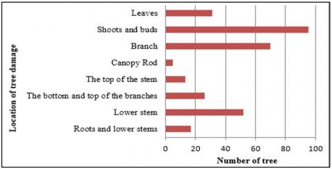
The location of tree damage describes the location or position of the damage in each mangrove tree. Observation of tree damage is done by looking at the whole tree (starting from the bottom). Therefore, not all of the damage found was recorded as sample data, but instead, data on the damage that met the threshold criteria were taken from each location. The results of the observation of the area of damage to the mangrove forest showed that the sites of the most damage occurred in the shoots and shoots of 95 locations of damage (30.74%) (Figure 2).
Figure 2. Number of trees and location of tree damage
The damage that mainly occurs in mangrove forests can occur due to attacks by destructive pests or natural conditions that cause the leaves on the shoots and shoots to be damaged. Symptoms of hollow leaves occur due to bagworm pests. The bagworm eats the leaves, causing holes in the leaves. The type of bagworm found in the field was Pagodiella spp. and Acanthopsyche spp. The Pagodiella spp. is the primary pest that attacks the leaves in mangrove forests stands with considerable damage. This is because the species commonly found in the field are bagworms that have the characteristic of a pagoda-shaped pouch. According to Wahid [25], the most dominant species found in the mangrove forest field, both population and damage, is Pagodiella spp.
Figure 3. The damage location on shoots and buds
Based on Figure 3, the location of damage that mainly occurred in mangrove forests apart from the shoots and shoots was on the branches as much as 70 (22.65%) damage, lower stems as much as 52 (16.83%) damage leaves as much as 31 (10.03%) and the top and bottom of the branch as much as 26 (8.41%) damage. Therefore, the location of tree damage helps identify the type of tree damage that has occurred because each area of damage has different characteristics or types of damage symptoms.
3.1.2 Tree damage type
This type of tree damage is a form of plant growth disturbance whose symptoms can be seen from the shape, size, color, and texture. Tree damage disturbances occur due to disruption of physiological processes caused by disease, insects, and other abiotic causes. In addition, tree damage can also be caused by climate change. Climate change causes increased forest destruction and tree mortality from both direct and indirect causes [26]. Damage to trees can be caused by many unfavorable factors that result in disturbance to different tree species. According to Safe'i et al. [27], tree damage affects the physiological feature of trees, decreases tree growth rate, and reasons tree dying. This damage can also disrupt the functions of mangrove forests. An essential characteristic of mangrove ecosystems changed into a sequence that connected marine and terrestrial ecosystems (downstream watershed areas). In addition, mangrove forests produce large amounts of natural organic material, especially clutter, so that mangrove forests want to be maintained so that these features are conserved [22].
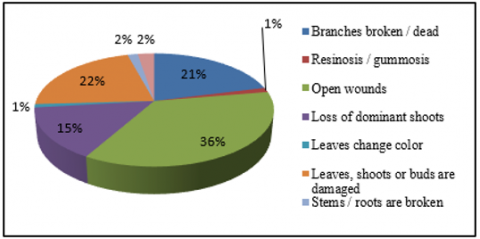
Based on Figure 4, the type of damage that is most commonly found is in the kind of damage to open wounds of plants that have damaged open wounds that will show peeling bark or branches, including fractures, but no further weathering has occurred. This damage is more likely to be caused by animals, for example, widening (such as crabs). The development of this open wound will cause more damage if it is later associated with a disease or strong winds. Several factors can also cause open injuries. Namely, the result of human behavior and can also occur due to natural events such as friction between trees, damage to open wounds can also occur due to stem destroying pests found in the form of termite attacks, which make houses along the trunk road to the branches. In addition, termite attack (Prorhinotheres sp.) causes damaged tissue in branches and trunks, resulting in the death of mangrove branches and stems. Besides that, it is also caused by the competition of plants to seek nutrient intake from sunlight. This type of damage dramatically affects the physiological processes of plants because open wounds appear on the stem. The trunk is the food transportation route for the tree, and if the item is damaged, the process will be disrupted.
Figure 4. Percentage of trees and type of tree damage that occurred at the study site
Figure 5. Type of damage: Open wound (a); damaged buds, foliage and shoots (b)
Other types of damage often found are hollow leaves, shoots, and shoots damaged by strong winds or pests. This damage can occur due to pests or diseases. According to Ardiansyah and Safe’i [28], the type of damage can be caused by various factors, such as disease, pest attacks, weather, and animals. Pests that attack the leaves of mangrove trees are of the type Lepidoptera in the larval stage. Symptoms of leaves eaten by Lepidoptera larvae are that the leaves become hollow, turn yellow, and fall. This makes it difficult for the leaves to carry out the photosynthesis process, affecting the food transportation system in mangrove trees. Another result is that these larvae damage the leaves, and eventually, the branches are also damaged to dry and rot. Type of gamage can be seen in Figure 5.
Other damages found quite a lot were in broken / dead branches and loss of dominant shoots. Pests and diseases can cause this damage. Another indication of the cause is competition between mangrove trees in the mangrove forest area. This competition between mangroves is due to healthy competition, especially in the mangrove forest areas of Labuhan Maringgai, Pasir Sakti, and TNWK sub-districts composed of the same or homogeneous mangrove trees, namely Avicennia marina and Rhizophora sp. For example, according to Bintoro [29], Mangrove forests in East Lampung Regency (Labuhan Maringgai, Pasir Sakti, and TNWK sub-districts) are dominated by white api-api mangroves (Avicennia marina) and oil mangroves (Rhizophora apiculata). Likewise, the damage to the ecosystem of protected mangrove forest areas: conversion of mangrove forests that are no longer environmentally friendly, pollution and illegal logging, and impacts on the human component [27]. The loss of the dominant shoot due to drought will be followed by death that causes a fracture. This damage causes many shoots to grow on the main stem, so plant growth decreases, reduces wood production, and produces trees of low economic value.
3.1.3 Severity threshold value
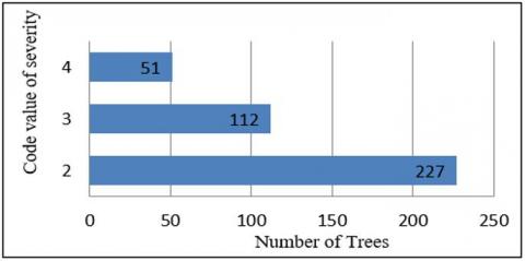
The threshold value of severity is a value that describes the amount of seriousness of a type of damage; The severity threshold value is used to record the kind of damage to the tree. If it meets the threshold of severity, the type of tree damage can be recorded, but if the damage does not meet the seriousness threshold, the damage is not registered. For example, the highest severity level is found in code 2 with a class of severity values between 20-29%, a relatively high second severity level occurs in code 3 with a severity value between 30-39%, and for the second-highest severity level is code 4 with a severity class. In the amount of 40-49%. The number of trees and the code for the severity threshold that occurred at the research location can be seen in Figure 6.
Figure 6. The level of attack severity in mangrove forests
3.2 Value of mangrove forest health status
The damage level index is classed into two ranges: the Plot Level Index (PLI) and Cluster Level Index (CLI) indices. The index threshold for the level of harm to mangrove forests is classed into good, medium and bad (Table 4). The outcomes of the mangrove forest power popularity are shown in Table 5.
Based totally on the multiplication result among the weighted value and the value of the ecological indicator parameter score for woodland fitness in each FHM plot, the very last value of mangrove forest health is obtained. The weighted value used to assess the health of mangrove forests refers to research conducted by Safe'i et al. [30] with a value of 0.45. The results of the forest health assessment are shown in Table 5.
Table 4. Threshold values of vitality in community forests
|
Class threshold values of vitality in mangrove forest |
Vitality categories of mangrove forest |
|
5.50 – 6.75 |
Good |
|
4.06 – 5.40 |
Medium |
|
2.70 – 4.05 |
Bad |
The common wooded area health circumstance inside the coastal vicinity of East Lampung Regency is in the medium category with a median NKH value of 5,04. The mangrove woodland in the seaside place of East Lampung Regency is applied and controlled by the encompassing community, particularly people who depend on the mangrove woodland. The mangrove forest in East Lampung Regency is a protected forest, so this forest area is naturally intended to regulate water management, prevent floods and erosion, and maintain soil fertility. So far, the government and the community have worked together to conserve mangrove forests. This is consistent with the statement of ref. [31], which states that in overcoming forest degradation and land degradation, forest conservation efforts are needed through various conservation programs from the government and involving communities around the forest. Therefore, the mangrove forests in East Lampung Regency are managed and developed synergistically by the local community, regional government, and central government so that the health condition of the mangrove forests is well maintained.
Table 5. Final values of forest health (NKH) in mangrove forests
|
Plot Cluster |
NKH |
Category |
|
1 |
4.95 |
Medium |
|
2 |
4.95 |
Medium |
|
3 |
5.40 |
Medium |
|
4 |
6.30 |
Good |
|
5 |
4.95 |
Medium |
|
6 |
2.70 |
Bad |
|
7 |
6.30 |
Good |
|
8 |
6.75 |
Good |
|
9 |
5.40 |
Medium |
|
10 |
2.70 |
Bad |
|
Average |
5.04 |
Medium |
The health status value of mangrove forests within the coastal regions of East Lampung Regency is typical at medium criteria (5.04). This is because the mangrove forests in East Lampung Regency are used and managed through local groups, mainly individuals who rely on those mangrove forests. So far, the government and the community have worked together to conserve mangrove forests. As a result, the mangrove forests in East Lampung Regency are managed and evolved synergistically by the local people, regional government, and central government so that the health condition of the mangrove forests is well maintained.
[1] Kordi, K.M.G.H., Ghufran, H. (2012). Ekosistem Mangrove: Potensi, Fungsi dan Pengelolaan. Jakarta: Rineka Cipta, 256.
[2] Igulu, M.M., Nagelkerken, I., Dorenbosch, M., Grol, M.G., Harborne, A.R., Kimirei, I.A., Mgaya, Y.D. (2014). Mangrove habitat use by juvenile reef fish: meta-analysis reveals that tidal regime matters more than biogeographic region. PloS One, 9(12): e114715. https://doi.org/10.1371/journal.pone.0114715
[3] Ritohardoyo, S., Ardi, G.B. (2014). Arahan kebijakan pengelolaan hutan mangrove: Kasus Pesisir Kecamatan Teluk Pakedai, Kabupaten Kuburaya, Provinsi Kalimantan Barat. Journal of Geografi., 11(1): 43-57. https://doi.org/10.15294/jg.v8i2.1659
[4] Carugati, L., Gatto, B., Rastelli, E., Lo Martire, M., Coral, C., Greco, S., Danovaro, R. (2018). Impact of mangrove forests degradation on biodiversity and ecosystem functioning. Scientific Reports, 8(1): 1-11. https://doi.org/10.1038/s41598-018-31683-0
[5] Giri, C., Pengra, B., Zhu, Z., Singh, A., Tieszen, L.L. (2007). Monitoring mangrove forest dynamics of the sundarbans in bangladesh and india using multi-temporal satellite data from 1973 to 2000. Estuarine, Coastal and Shelf Science, 73(1-2): 91-100. https://doi.org/10.1016/j.ecss.2006.12.019
[6] Darmawan, A., Hilmanto, R. (2014). Perubahan tutupan hutan mangrove di pesisir kabupaten lampung timur. Jurnal Sylva Lestari, 2(3): 111-124. http://dx.doi.org/10.23960/jsl32111-124
[7] Ellison, J.C., Zouh, I. (2012). Vulnerability to climate change of mangroves: Assessment from Cameroon, Central Africa. Biology, 1(3): 617-638. https://doi.org/10.3390/biology1030617
[8] Bintoro, A. (2014). Inventarisasi jenis tumbuhan obat di hutan mangrove desa margasari kecamatan labuhan maringgai lampung timur. Jurnal Sylva Lestari, 2(1): 67-76. http://dx.doi.org/10.23960/jsl1267-76
[9] Cesario, A.E., Yuwono, S.B., Qurniati, R. (2015). Partisipasi kelompok masyarakat dalam pelestarian hutan mangrove di desa margasari kecamatan labuhan maringgai kabupaten lampung timur. Journal Sylva Lestari, 3(2): 21-30. https://doi.org/10.23960/jsl2321-30
[10] Desmania, D., Harianto, S.P., Herwanti, S. (2018). Partisipasi kelompok wanita cinta bahari dalam upaya konservasi hutan mangrove (cinta bahari women's group participation on mangrove forest conservation). Jurnal Sylva Lestari, 6(3): 28-35. http://dx.doi.org/10.23960/jsl3628-35
[11] Putra, A.K., Bakri, S., Kurniawan, B. (2015). Peranan ekosistem hutan mangrove pada imunitas terhadap malaria: studi di kecamatan labuhan maringgai kabupaten lampung timur (role of mangrove forest ecosystem in immunity to malaria: Study in sub-district labuhan maringgai district east lampung). Journal Sylva Lestari, 3(2): 67-78. https://doi.org/10.23960/jsl2367-78
[12] Prasetyo, D., Darmawan, A., Dewi, B.S. (2019). Persepsi wisatawan dan individu kunci tentang pengelolaan ekowisata di Lampung mangrove center (perceptions of tourists and key individuals on ecotourism management in Lampung mangrove center). Journal Sylva Lestari, 7(1): 22-29. http://dx.doi.org/10.23960/jsl1722-29
[13] Ponnambalam, K., Chokkalingam, L., Subramaniam, V., Ponniah, J.M. (2012). Mangrove distribution and morphology changes in the mullipallam creek, south eastern coast of India. International Journal of Conservation Science, 3(1): 51-60.
[14] Rudianto, R., Bengen, D.G., Kurniawan, F. (2020). Causes and effects of mangrove ecosystem damage on carbon stocks and absorption in East Java, Indonesia. Sustainability, 12(24): 10319. https://doi.org/10.3390/su122410319
[15] Sumardi, W.S., Widyastuti, M. (2004). Dasar-dasar perlindungan hutan. Yogyakarta: Gajah. 228p.
[16] Rochmah, S.F., Safe’i, R., Bintoro, A., Kaskoyo, H., & Rahmat, A. (2021). The effect of forest health on social conditions of the community. In IOP Conference Series: Earth and Environmental Science , 739(1): 012016.
[17] Safe’i, R., Darmawan, A., Kaskoyo, H., Rezinda, C.F.G. (2021). Analysis of changes in forest health status values in conservation forest (case study: plant and animal collection blocks in wan Abdul rachman forest park (Tahura war)). In Journal of Physics: Conference Series, 1842(1): 012049.
[18] Wulff, S., Roberge, C., Ringvall, A.H., Holm, S., Ståhl, G. (2013). On the possibility to monitor and assess forest damage within large scale monitoring programmes–A simulation study. Silva Fennica, 47(3): 1000. http://dx.doi.org/10.14214/sf.1000
[19] Safe’i, R., Sari, R.N., Iswandaru, D., Latumahina, F. S., Taskirawati, I., Kaskoyo, H. (2021). Biodiversity and site quality as indicators of mangrove forest health pasir sakti, Indonesia. Annals of the Romanian Society for Cell Biology, 4400-4410.
[20] Woodall, C.W., Amacher, M.C., Bechtold, W.A., Coulston, J.W., Jovan, S., Perry, C.H., Will-Wolf, S. (2011). Status and future of the forest health indicators program of the USA. Environmental Monitoring and Assessment, 177(1): 419-436. https://doi.org/10.1007/s10661-010-1644-8
[21] Safe'i, R., Latumahina, F.S., Suroso, E., Warsono, W. (2020). Identification of durian tree health (Durio Zibethinus) in the prospective nusantara garden wan abdul rachman lampung Indonesia. Plant Cell Biotechnology and Molecular Biology, 21(41-42): 103-110.
[22] Safe'i, R. (2014). Value of vitality status in monoculture and agroforestry planting systems of the community forests. International Journal of Sciences: Basic and Applied Research (IJSBAR), 18(2): 340-353.
[23] Nuhamara, S.T., Kasno., Irawan, U.S. (2001). Assessment on damage indicators in forest health monitoring to monitor the sustainability of Indonesian tropical forest, “in Forest Health Monitoring to monitor the sustainability of Indonesian tropical rain forest,” in Forest Health Monitoring to Monitor. The Sustainability of Indonesian Tropical Rain Forest, 1st ed., I.C. Stuckle, C.A. Siregar, Supriyanto, J. Kartana, Ed. Yokohama: ITTO and Bogor: Seameo-Biotrop, 2: 95-125.
[24] Johnson, W.T., Lyon, H.H. (1976). Insects that Feed on Trees and Shrubs. Ithaca, NY: Comstock Publishing Associate, Cornell University Press, 1-556.
[25] Wahid, A. (2010). Efikasi bioinsektisida dan kombinasinya terhadap serangan hama ulat kantong pagodiella spp. Pada Bibit Mangrove Rhizophora spp. di Persemaian. Agroland: Jurnal Ilmu-ilmu Pertanian, 17(2): 162-163.
[26] Tuominen, J., Lipping, T., Kuosmanen, V., Haapanen, R. (2009). Remote sensing of forest health. Geoscience and Remote Sensing, 161-166.
[27] Safe'i, R., Latumahina, F.S., Sari Dewi, B., Ardiansyah, F. (2021). Assessing the state and change of forest health of the proposed arboretum in Wan Abdul Rachman Grand Forest Park, Lampung, Indonesia. B Iod Iversitas, 22(4): 2072-2077.
[28] Ardiansyah, F., Safe’i, R. (2021). Analysis of changes in health of coastal mangrove forest on the east coast of Lampung. In IOP Conference Series: Earth and Environmental Science, 755(1): 012028. http://dx.doi.org/10.1088/1755-1315/755/1/012028
[29] Bintoro, A. (2014). Inventarisasi jenis tumbuhan obat di hutan mangrove desa margasari kecamatan labuhan maringgai lampung timur. Journal Sylva Lestari, 2(1): 67-76. http://dx.doi.org/10.23960/jsl1267-76
[30] Safe'i, R., Wulandari, C., Kaskoyo, H. (2019). Penilaian kesehatan hutan pada berbagai tipe hutan di Provinsi Lampung. Journal Sylva Lestari, 7(1): 95-109.
[31] Fuller, L., Quine, C.P. (2016). Resilience and tree health: a basis for implementation in sustainable forest management. Forestry: An International Journal of Forest Research, 89(1): 7-19. https://doi.org/10.1093/forestry/cpv046