Mochamad Ainul Yaqin*![]() | Suyahmo
| Suyahmo![]() | Puji Hardati
| Puji Hardati![]() | Hamdan Tri Atmaja
| Hamdan Tri Atmaja![]() | Nur Hamid
| Nur Hamid![]()
© 2024 The authors. This article is published by IIETA and is licensed under the CC BY 4.0 license (http://creativecommons.org/licenses/by/4.0/).
OPEN ACCESS
Culture or local wisdom is very important for environmental sustainability in areas such as Jember, where the ecological potential is that there are many “Gumuk” fields that used to stand strong but are now starting to be eroded or exploited by local and foreign communities. This research aims to analyze the role of local wisdom in preserving “Gumuk” in Kaliwates District, Jember Regency, and develop a concept for local wisdom-based community education for “Gumuk” conservation in Jember. This research was carried out using phenomenological methods and descriptive analysis, and then the Likert scale became the data analysis technique used in this research. This research shows that local wisdom is valuable and benefits people’s lives. Local wisdom is part of life’s way of solving all life’s problems. There needs to be a role for local wisdom of the community to maintain and preserve existing “Gumuk” so that they are not continuously exploited following the increasing needs of the community. Applying local wisdom in keeping “Gumuk” is the government’s basis for creating conservation policies. Community-based education is a mechanism that provides opportunities for everyone in society to enrich knowledge and technology through lifelong learning.
local wisdom, sustainable environment, “Gumuk” Jember regency, community-based education
In the era of globalization, humans must adapt to constantly changing developments. Therefore, humans continue to be required to fill themselves to be able to compete on a global level. Thus, humans are expected to be able to look for breakthroughs (innovation) in solving life’s problems. The potential of local wisdom needs to be passed on to the younger generation through character education so that their identity as the primary guide becomes stronger amidst the onslaught of global culture. To pass on local values through education in the context of globalization, the younger generation must be educated about the importance of local wisdom through character education to strengthen their identity as the leading guide amidst the onslaught of global culture.
Local wisdom is an outlook on life grounded in reasoned arguments, polite behavior, and positive attributes. It may be understood as the product of reason, intense emotions, routines, temperamental types, and suggestions for the magnificence of humanity [1]. Local wisdom refers to perspectives on life, knowledge, and different living techniques that local communities use to address various issues and satisfy their needs [2].
Local wisdom plays an essential role in supporting the nation’s progress. Local wisdom refers to the way of life, knowledge, and different living tactics that local communities use to address various issues and satisfy their needs. A system in local communities’ social, political, cultural, economic, and environmental existence that is founded on reasoned behavior, polite behavior, and the presence of positive things is known as local wisdom. So, you can differentiate between local culture and modern culture.
Culture or local wisdom is essential for environmental sustainability in areas such as Jember, where the ecological potential has many “Gumuk” that previously stood firm but are now starting to be eroded or exploited by local communities or outside. Society has an essential role in forming culture so that it continues to survive the times, both directly and indirectly, by utilizing abilities so that humans can master nature. Local wisdom will endure if the community upholds and applies its current beliefs, laws, customs, and values.
“Gumuk” for Jember people is certainly nothing new. Jember’s topography is known to have many “Gumuk” spread across several sub-districts. We find more “Gumuk” in the North Jember area, which are relatively large and tall compared to the South Jember area. “Gumuk” is a characteristic of the Jember district. Even the names of several regions of the Jember district use the word “Gumuk”, for example, “Gumuk Mas”, “Gumuk Rase”, or “Gumuk Bago”. In the Balung sub-district, there are also several “Gumuk”. One of them is “Gumuk” Lateng, which is very popular and legendary among the residents of Balung Lor and its surroundings.
Based on data from the BPK Representative for East Java Province, the Jember Regency has an area of 3,293.34 km 2. It has approximately 76 small islands, the most significant being Nusa Barong Island. Based on its geographical position, Jember Regency has boundaries [3]:
Jember Regency is a city with many “Gumuk” or hills, which is given the nickname City of a “Thousand Gumuk”. It is one of the nicknames for Jember Regency, which has unique natural resources, namely “Gumuk”. Until now, the existence of “Gumuk” is still found. Unfortunately, now, the numbers do not match the nickname given to them because of the large amount of exploitation and mining carried out by the community.
Based on data from the Kab. Sanitation White Book. In 2012, the number of “Gumuk” in Jember Regency was 1,670. In the last five years, the “Gumuk” have decreased; 29 “Gumuk” have been razed to the ground (damaged), and 27 “Gumuk” are in the process of exploitation out of a total of 473 “Gumuk” recorded in government documents on natural resources. In the last five years, 11 percent of the “Gumuk” have been damaged. “Gumuk” is exploited mainly in the Sumbersari sub-district area. This exploitation is expected to continue to increase and will significantly impact damage to the macro ecosystem in Jember Regency [3].
Exploitation is at the heart of the current “Gumuk” damage. The exploitation carried out does have an economic impact, namely income for some communities and the private sector. However, on the other hand, environmental ecology is experiencing degradation, thus disrupting ecological stability. If preventive measures are not taken, the quality of the environment in Jember Regency will deteriorate, resulting in consequences for the community.
The problem is related to the many exploitations of “Gumuk” carried out by local communities and outside parties, which result in tornadoes. So, educating the community about the “Gumuk” is necessary to protect and preserve it so that ongoing disasters do not occur. The continued exploitation of “Gumuk” occurs due to the increasingly dense and growing development of society and people’s thinking about clearing land as a place to live. Here, there needs to be a role for the local wisdom of the people around “Gumuk” to protect and preserve nature so that ongoing disasters do not occur.
The absence of regulations and policies that protect the “Gumuk” areas has resulted in a decrease in the number of “Gumuk” areas in the Jember Regency. There must be clear regulations regarding “Gumuk” mining as a type C excavation mine. “Gumuk”, which has already been exploited, can no longer be reclaimed because it has changed its function to become a residential area (housing). There needs to be a regional regulation to protect still-intact “Gumuk” so they can continue to exist and benefit the community.
Population growth occurs due to the large influx of immigrants, which causes the emergence of various social implications such as socio-cultural interactions, occupational differentiation, population density, lack of residential land, economic growth, and various other social problems. It is usual for cities or districts in Indonesia, such as the Kaliwates sub-district in the middle of Jember Regency, to be a favorite destination for migration and urbanization of residents with good educational and economic motivation. As the heart of Jember Regency, Kaliwates District is an area with a very significant increase in population, as seen from BPS Jember data. Kaliwates District has seven subdistricts in it, such as Jember Kidul, Tegal Besar Subdistrict, Kaliwates Subdistrict, Kepatihan Subdistrict, Mangli Subdistrict, Sempusari Subdistrict, and Kebon Luhur Subdistrict, which are close to government offices, shopping centers and good educational places. So Kaliwates District has become a popular area, a center for migration and urbanization.
Based on research shows that population growth in each sub-district is increasing every year. Of the seven sub-districts, it is known that the Tegalbesar sub-district has the largest population compared to other sub-districts. Population growth will influence socio-cultural values, indirectly changing the values themselves. Population growth can change the community’s social culture by preserving the “Gumuk” in their current environment. Socio-cultural changes in society in safeguarding “Gumuk” usually use traditional models and tools, and population growth and technological advances will find new technology to preserve “Gumuk.” The socio-cultural values that have been carried out by the community around the “Gumuk” land, such as cooperation, village clean-up, and community service, are still embedded in the community, as can be seen from the people who are always present when cooperation, village clean-up, and community service activities are held. The people who attended this activity tried to do good things to preserve “Gumuk.” Apart from safeguarding “Gumuk,” the community is trying to maintain the integrity of “Gumuk” from miners or exploitation of “Gumuk”.
Furthermore, in terms of human resources and skills, the community always tries to participate in managing the “Gumuk” land, for example, through cooperation activities held to clean up the “Gumuk” structurally. Among the things that have been done are planting trees, placing large rocks on the edges of the “Gumuk,” and building shelters such as houses in the middle of rice fields. People with specific skills, such as those who work as bricklayers and builders, are quick to contribute their complementary construction talents or do not require wages.
The existence of “Gumuk” in the Jember area is challenging to identify in terms of number and ownership status. This is due to the frequent exploitation of “Gumuk”, which can reduce the number of “Gumuk” in the Jember area. The city of Jember, once known as the city of a thousand “Gumuks”, is trying to preserve “Gumuk” and local culture. To remain alive during changing times and not only be considered a work of art, this effort must continue to be carried out because of the various existing problems; researchers intend to research “Gumuk”. This research aims to analyze the role of local wisdom in preserving “Gumuk” in Kaliwates District, Jember Regency, and develop a concept for local wisdom-based community education for “Gumuk” conservation in Jember.
The practical benefits obtained from this research include: increasing knowledge for the community, which can serve as a guide in preserving “Gumuk”; providing a forum for community participation and collaboration in “Gumuk” preservation efforts; establishing a foundation for effective coordination between the community and the government; offering additional information for “Gumuk” conservation efforts, adaptable to different regions; serving as role models for educating the community on contextual “Gumuk” conservation with active community involvement; providing input for formulating “Gumuk” conservation models based on local wisdom; and serving as a basis for the government to develop conservation policies.
The article’s structure consists of an introduction, which briefly explains the sustainable management of the “Gumuk” environment based on local community wisdom, a literature review, methods, results, and a discussion of the research, presenting a comparison of the study with existing research. Ends the conclusion section with the results obtained and an overview of the prospects for further research.
Leo Agung S’s research entitled “The Development of Local Wisdom-Based Social Science Learning Model with Bengawan Solo as the Learning Source” stated that there are no learning sources based on local wisdom, and students do not know the importance of Bengawan Solo. An appropriate model is needed to develop a social studies learning model based on the local knowledge of Bengawan Solo. The research was carried out using descriptive qualitative methods, observation, interviews, document analysis, and FGDs and questionnaires. Meanwhile, an interactive qualitative analysis model is needed for data accuracy. Finding a suitable model for implementing local wisdom in schools, encouraged by the school and community leaders. The results of this research are that students can understand the importance of existing local wisdom even though they study at school. And the problem-based contextual learning model used by teachers in schools [4].
Vitasurya [5] provides the conclusion of the research paper entitled “Local Wisdom for Sustainable Development of Rural Tourism, Case on Kalibiru and Lopati Village, Province of Yogyakarta Special Region” conducted by Vitasurya, namely community participation as the basis for sustainable development of rural tourism. Based on the results of observations comparing the two villages, it can be seen that community participation in developing tourism can be seen from community involvement through community participation in packaging a variety of attractions, such as educational tourism, which teaches skills in creating simple home industries according to the type of business owned community participation in developing their infrastructure and facilities to support the craft industry, making tourist attractions more attractive to tourists. Community involvement to participate in the guard / “Marshall” group to preserve the “wawengkon” land and keep it sustainable.
Furthermore, research conducted by Chaiphar et al. [6], “Local Wisdom in the Environmental Management of a Community: Analysis of Local Knowledge in Tha Pong Village, Thailand”. Most importantly, activities organized by community members are usually related to sustainable conservation of the environment and natural resources. Everyone in society understands that their way of life and existence depends on natural resources. They realize that if the environment is damaged, all members of society will suffer various economic and social effects. Another phenomenon is the Pong villages’ “tree consecration” ceremony to protect their community forests from exploitation.
3.1 Research design
This research uses a qualitative approach. A qualitative approach is research that examines participant perspectives with interactive and flexible strategies. This approach was taken to obtain data from the community, especially “Gumuk” in Kaliwates District. This research was carried out using phenomenological methods and descriptive analysis.
3.2 Research variable
The research variables used to answer the research objectives include Knowledge about “Gumuk”, Local Community Wisdom, Internalization of preservation materials, Participatory mapping, and community education models.
3.3 Research subject
This research was conducted in three subdistricts: Tegal Besar Subdistrict, Mangli Subdistrict, and Talangsari Subdistrict in Kaliwates District, Jember City. Researchers chose this location because there are still many “Gumuk” in this area, and it is a sub-district located in the city center. Informant Selection Technique: The selection of informants for this research was determined by snowballing 24 informants. Snowball sampling is a technique for selecting informants whose number is initially tiny and then giving a stimulus to choose the next informant so that the number of informants increases significantly.
3.4 Research focus
This research focuses on the local wisdom of the community in preserving the remaining “Gumuk” in Jember, especially in Kaliwates District. By using an educational approach to the community around the “Gumuk” land. To reveal the values of local wisdom and education of the community around the “Gumuk” land in preserving the “Gumuk”.
3.5 Data collection techniques and instruments
The data used for this research is qualitative. Qualitative data is text or narrative, descriptive documents, images, and recordings obtained directly through observations and surveys in the field. The data collection techniques used in this research are information, phenomenology, and documentation.
3.6 Data analysis technique
The data analysis method employed in this study is the Likert scale. The Likert scale gauges an individual’s or a group’s attitudes, beliefs, and perceptions on social issues [7]. Data obtained from the questionnaire results were converted into scores with two scales because it used an even 2-point Likert scale (Table 1).
Table 1. Likert scale
|
Category |
Score |
|
No |
1 |
|
Yes |
2 |
Formula: T × Pn T = Total Respondents who voted
Pn = Choice of Likert score numbers.
4.1 Concept of local wisdom
Local wisdom values can control and provide direction for cultural development. Thus, it is correct to say that culture manifests a society’s personality. This means that people’s identity is reflected in the orientation that shows their outlook on life and value system, the patterns and attitudes of life that manifest in daily behavior, and the lifestyle that colors their lives. The position of local genius is very significant in the context of the cultural existence of a society or group.
This is because it is a force that can withstand elements that come from outside and can also develop for the future. The disappearance or fading of local genius also means the fading of a society’s personality, while the strength of local genius to survive and develop also shows the personality of that society.
Local wisdom is seen as knowledge and methods for preserving ecological balance and regulating the natural world with a human face. These methods have been put to the test for ages by a variety of natural calamities, human carelessness, and natural barriers [8]. A perspective on life, knowledge, and diverse living tactics in the form of actions taken by local communities in response to various issues in satisfying their needs is collectively referred to as local wisdom. The demands fulfillment system includes all facets of religion, science, economics, technology, social structure, language and communication, and the arts.
This local wisdom is related to specific communities. A community is a social unit or unit that is organized into groups with shared interests (communities of common interest), both functional and territorial. The term community can be translated as “local community.” The local wisdom of the Jember people regarding the preservation of “Gumuk” has been passed down from generation to generation, and some pay less attention to the preservation of the “Gumuk” due to economic needs and the lure of other parties to sell the “Gumuk” for exploitation or mining by the new owner. Applying local wisdom in Jember Regency is very influential in preserving “Gumuk”.
Three terms are often used to understand local wisdom: local knowledge, wisdom, and intelligence. The term traditional knowledge (local knowledge) is everything related to conventional (local) forms, be it an activity or the result of a work that is usually based on a particular culture [9].
Aulia and Dharmawan [10] states that every community has local wisdom. Local wisdom is a process for “becoming smart and knowledgeable “Local wisdom is considered very valuable and benefits people’s lives. Local wisdom is part of life’s way of solving all life’s problems.
Local wisdom (local wisdom or local genius) is a local (regional) concept or notion that embodies sensible, imaginative, and compassionate ideals that have been ingrained from generation to generation (tradition) is known as local wisdom, local genius, or local knowledge. The community adheres to these principles because it believes them to be true. This local knowledge is the community’s noble ideals (adhiluhung), which serve as a conceptual foundation for moral action that leads to harmony [11].
According to Wales, as quoted by Nasiwan [12], local wisdom can be seen from two opposing perspectives. Namely extreme acculturation and a less radical acculturation. Extreme acculturation shows imitation forms of a culture without any process of cultural evolution and ultimately destroys traditional cultural forms. Meanwhile, less powerful acculturation is an acculturation process that remains and shows local genius. Namely, the existence of conventional elements or characteristics that can survive and even have the ability to accommodate cultural elements from outside and integrate them into the original culture.
Sudarmin et al. [13] show the conservation values and local wisdom contained in communities and areas. Publications care for and maintain conservation values and wisely utilize biological resources, marine fish, marine life, seaweed, turtles, and coral reefs. Another moral characteristic of the Karimunjawa people is obeying all the rules and written appeals on bulletin boards related to forest and wildlife conservation, beaches, and holy places. This study revealed that local knowledge is still maintained as Dewandaru, Setigi, and Kalimosodo. This also found the positive character values of community leaders (Sunan Nyamplungan) and fishermen and tour guides: religious enthusiasm, hard work, responsibility and love of the nation, concern for the environment, independence, and democracy.
The study [5] is about community participation, and based on the results of observations comparing the two villages, it can be seen that community participation in developing tourism can be seen from community involvement through community participation in packaging a variety of attractions, such as educational tourism, which teaches skills in creating simple home industries according to the type of business owned. Community participation in developing their infrastructure and facilities to support the craft industry, making tourist attractions more attractive to tourists.
4.2 The foundation for “Gumuk” and sustainable conservation
Jember Regency is one of the cities that has many “Gumuk” or hills, which is given the nickname City of a Thousand “Gumuk” which is one of the nicknames for Jember Regency which has unique natural riches, namely “Gumuk”; this was initially caused by the eruption of Mount Raung in the past (from Raung Purba) [14]. Until now, the existence of “Gumuk” is still found. Unfortunately, now, the numbers do not match the nickname given to them because of the large amount of exploitation and mining carried out by the community [15].
Apart from being nicknamed the city of a thousand “Gumuk”, Jember is nicknamed the Tobacco City because it produces the primary commodity and is the largest tobacco producer. Jember is also known as the City of Carnival, thanks to the Jember Fashion Carnival (JFC), which has gone global and is widely imitated by other regions. In terms of typical food or souvenirs, it is known as Kota Suwar Suwir, which is a typical food made from tape that is processed in such a way as to produce food like dodol but harder.
The “Gumuk” that the people of Jember know is different from the hill that people outside Jember often say because the “Gumuk” is a high mound similar to a small mountain and hill. However, it is different between “Gumuk” and hills. Several erroneous assumptions state that “Gumuk” are hills, even though clearly, the two are other because the contents of hills and “Gumuk” have apparent differences. “Gumuk” enters the C excavation mine with a load of plate stone, sand, and foundation stone. For example, most of a hill contains ordinary soil. And each has its advantages.
“Gumuk” is a unique term given to a hill, with heights ranging from 1 meter to 57.5 meters. The main element of “Gumuk” is rock. Because “Gumuk” come from volcanic eruptions. The top of the “Gumuk” becomes fertile soil. This is because the “Gumuk” formation has changed over thousands of years, and the weathering process has occurred. The various types of rock in the “Gumuk” are rock, foundation stone, coral, plate stone, and sword stone. That is what invites the exploitation of “Gumuk” for the economy.
“Gumuk” is not only found in rural areas but also many urban areas. Therefore, some “Gumuk” can sometimes be used as city lungs. The function of the “Gumuk” is to neutralize the wind so that high-speed wind when it hits the “Gumuk”, will be reflected in all directions at low speed. “Gumuk” is also part of the earth’s stake in maintaining natural balance. “Gumuk” is a living place for an ecosystem, providing cool weather in the surrounding area and a place to store large amounts of water so that erosion, floods, and drought do not occur. It can also be used to enjoy the natural beauty of the high “Gumuk” peaks [16].
The existence of “Gumuk” in Jember Regency is utilized by the community for economic needs, without paying attention to environmental aspects, but is more profit-oriented by exploiting the “Gumuk”. Concern for the “Gumuk” is increasingly fading. Public awareness and government policy led to the status of “Gumuk” as private property, ultimately leading to economic problems for the “Gumuk” owners [17]. This occurs because the high population in the Jember area is not balanced with consistent control of space utilization and control of environmental damage.
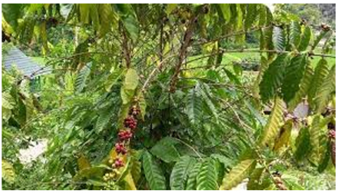
Figure 1. Use of “Gumuk” land (Coffee)
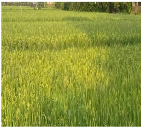
Figure 2. Use of “Gumuk” land (Rice)
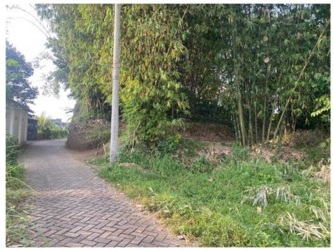
Figure 3. Use of “Gumuk” land (Bamboo)
The functions of “Gumuk”, like the functions of hills, include geological, ecological, hydrological, aesthetic, economic, defense, educational, and tourism functions. The community has carried out the use of “Gumuk” as moorland, gardens, or mining. “Gumuk” as moorland is used for planting tobacco, cassava, peanuts, soybeans, horticulture, sengon, fruit plants, and coffee (Figures 1, 2, and 3), while the land around the “Gumuk” is generally used for growing tobacco as shown in Figure 4.
Figure 4. Use of “Gumuk” land (Tobacco)
Several factors cause the “Gumuk” to be exploited: 1. The “Gumuk” contain excavated elements C: plate stone, sand, and foundation stones; 2. “Gumuk” are exploited due to the expansion of the land to be used as land or housing. Several of these factors have resulted in the “Gumuk” being controlled by investors, individuals, and local communities living in the “Gumuk” area [18].
Astutik [19] has carried out an initial inventory of “Gumuk” in 8 sub-districts in the Jember area, namely Kalisat, Ledokombo, Pakusari, Sumberjambe, Jelbuk and Arjasa sub-districts. The research results showed that the number of “Gumuk” in these eight sub-districts was 442, with 386 “Gumuk” still intact and 56 having undergone the mining process. Seven sub-districts have a clustered “Gumuk” distribution pattern: Kalisat, Ledokombo, Pakusari, Sukowono, Sumberjambe, Sumbersari, and Jelbuk. However, people need to understand the existence of the “Gumuk”; people are more concerned with the economic value contained in the “Gumuk”. Here, the “Gumuk” owners treat the “Gumuk” as they please without paying attention to its benefits for the surrounding community.
Survey data in 2005 stated that of the 997 “Gumuk” in Jember, 174 had been exploited. In detail, 94 pieces are still partially influenced, 62 are affected, and 18 have been thoroughly influenced. This number will likely increase, considering the bright prospects for plate stone. Meanwhile, the latest datas for 2007 from the Jember Regency Development Planning Agency (Bappekab) are shown in the Table 2.
Table 2. Exploitation of “Gumuk”
|
No. |
Subdistrict |
Amount |
Remainder |
|
|
Reserve |
Mined |
|||
|
1 |
Sumbersari |
271 |
26 |
245 |
|
2 |
Kaliwates |
9 |
1 |
8 |
|
3 |
Patrang |
12 |
1 |
11 |
|
4 |
Arjasa |
6 |
1 |
5 |
|
5 |
Kalisat |
513 |
21 |
492 |
|
6 |
Source Jambe |
151 |
2 |
149 |
|
7 |
Pakusari |
300 |
11 |
289 |
|
8 |
Sukowono |
336 |
7 |
329 |
|
9 |
Jelbuk |
76 |
1 |
75 |
|
10 |
Ledokombo |
287 |
3 |
284 |
|
Total (Km2) |
1,961 |
74 |
1,187 |
|
Land use is all types of land use by humans, including agriculture, sports fields, residential houses, restaurants, hospitals, and cemeteries [18]. Restrictions regarding land use related to human activities on specific areas of land (settlements, urban areas, rice fields). In sociocultural variables and the public regions with playground indicators, the empirical facts are not found on the “Gumuk” but on grass fields in other places. If the “Gumuk” provides this facility on a limited scale, then there must be assistance and supervision for children from parents, considering the dangerous height of the “Gumuk”. Sports facilities are also minimal, and only certain ones can be provided due to the constraints of the height of the “Gumuk” and the large number of trees. Badminton, volleyball, and mini-football already exist on grass fields. Therefore, the types of sports suitable in the “Gumuk” environment are challenge sports, namely climbing, flying fox/hang skating, and rock climbing/rock climbing, provided that safety and security are guaranteed adequate facilities [20]. From the height contour, the peak of “Gumuk” reaches 9 meters from the surrounding road, while the grass field is flatter, only 20-40 cm from the surrounding road. The data analysis method employed in this study is the Likert scale. The Likert scale gauges an individual’s or a group’s attitudes, beliefs, and perceptions on social issues [7].
Land use also refers to using land and the natural environment to meet human needs in managing their lives. The definition of land use is usually used to refer to present or current land use based on data that shows land is used for farming rice, secondary crops, and cash crops. Because human activities on earth are dynamic, attention is often directed to qualitative and quantitative land-use changes [21].
Triggering factors for land use changes are always caused or triggered by various interacting factors. Factors or triggers are often referred to as driving forces. The combination of driving forces varies over time and space according to environmental and human conditions [22]. Biophysical factors such as climate change and fertility play an equally important role as human factors, which include economics and policy. Land use changes tend to be triggered by a combination of factors that work gradually and factors that occur irregularly (intermittently).
Economic capital, social networks, culture, and religion are attributes that are inherent in the social life of society and are embedded in the quality of values that are useful in directing, controlling, and attitudes of human behavior in their efforts to decide on problems related to human interests in social life in Jember. About the research object of “Gumuk”, the existence of “Gumuk” in Jember, the area around the community’s social life will be managed and functioned using the applicable norms inherent in this capital.
Jember Regency has a natural landscape that tends to be unique. One of the remarkable things is the distribution of “Gumuk”. The distribution of “Gumuk” in the Jember Regency is in the districts of Arjasa, Sumbersari, Jelbuk, Sukowono, Kalisat, Pakusari, Ledokombo, Mayang, and Sumberjambe. The inventory of “Gumuk” that have been carried out shows that in 2012, 11% of “Gumuk” had been damaged [23]. “Gumuk” exploitation tends to occur in Sumbersari District due to increased population and infrastructure development. This exploitation is expected to continue to improve and will significantly impact damage to the macro ecosystem in Jember Regency. Some of the identified impacts of “Gumuk” exploitation are negative impacts on communities around the “Gumuk”, such as hotter weather, frequent droughts, erosion, floods, strong winds, changes in microclimate, a decrease in the number of springs, a decrease in biodiversity, fewer urban forests, a decline population of “Gumuk”-dwelling animals [17].
According to the Jember Regency Public Works Department [24], it explains that in general, the type of soil in the “Gumuk” area is regosol. The soil is loose and fertile. The soil texture in the “Gumuk” tends to be sandy clay loam. This land is alluvial land affected by the action of volcanic rocks. Regosol soil tends to be sensitive to erosion, so vegetation cover maintains soil aggregate stability. Based on the description above regarding the interaction of the “Gumuk” ecosystem with the hydrological cycle, it is necessary to manage the “Gumuk” ‘s environmental services and the natural resources obtained from the “Gumuk”. “Gumuk” damage can disrupt the hydrological cycle, hurting nature and humans.
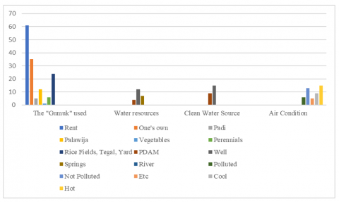
The existence of village land, which is the object of research based on data obtained from interviews, shows that around 64% of what is used for agriculture is rented land. This “Gumuk” is used for farming, including rice, secondary crops, hard crops, and vegetables. All land is widely used for rice fields, fields, and yards. Clean water sources are obtained from wells, PDAMs, and springs. Meanwhile, the air condition in the research village is that around 25% of the air is polluted, 37.5% is excellent, and 62.5% is hot.
Ellis and Pontius [22] mention six factors that generally trigger land use changes. These factors are changes in natural conditions, economic and technological, demographic, institutional, cultural, and globalization. Combining two or more factors will trigger land use changes
The impact of land use changes can be broadly divided into two categories. The first category is the impact on the environment (environmental impact), while the second category is the impact on socio-economic conditions. The first impact category receives more attention and publication than the second. This imbalance in attention is because the impact of the second category is more subtle and longer term, and the impact is influenced by more complex factors [25]. Land use is included in the sociocultural component because it reflects the results of human activities on land and its status [26].
Sustainable conservation of “Gumuk”, a rare phenomenon, can be preserved under certain conditions; on the other hand, a program to convert land around the “Gumuk” into activities that can create added value, especially for residents, is being developed. The land conversion that could be developed is for housing activities that support educational tourism (nature tourism), where geographers introduce the “Gumuk” as a natural laboratory (conservation aspect), then coastal agricultural activities (including fish ponds), as well as sand mining activities. Under control [27]. For this scenario to be achieved, a model balance is needed, in this case, if the parameter for the rate of addition of “Gumuk” area is the same as the parameter for land reduction. The preservation of “Gumuk” in this model is shown by controlling the area of “Gumuk” as a function of time.
Meanwhile, regional space that can be used for other purposes is available up to the area’s boundaries outside the “Gumuk”. This land use or land conversion can be used for building houses to support the development of educational tourism, controlled sand mining activities, or other activities such as agriculture. The concept of sustainable development, which is a compromise between conservation and conversion, can be implemented by controlling the “Gumuk” area and the possibility of utilizing resources such as tourism activities, limited sand mining, coastal agricultural cultivation, and residential purposes.
Figure 5. State of natural resources in “Gumuk” land
Figure 6. Physical conditions on “Gumuk” land
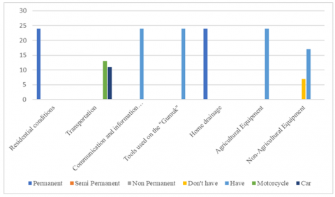
Figures 5 and 6 show the overall balance model of the village under study, showing the area that can be used for land conversion programs, housing, agriculture, and sand mining, and shows that the existence of “Gumuk” is maintained. Use for agriculture or housing and buildings. According to the time function, “Gumuk” preservation can be carried out by showing a constant graph of “Gumuk”; on the other hand, controlled exploitation in nature can be carried out through limited land conversion into housing, agriculture, or mining. So that this balance can be achieved, “Gumuk” is converted into land for other uses. The condition of the residents’ houses shows that they are all permanent and have their house drainage. The majority do not own agricultural and non-agricultural equipment. The community’s vehicles are cars and motorbikes; around 46% of people own cars, and the rest only own motorbikes. All communities have communication tools and tools used in the “Gumuk” fields.
In this research, the residents of “Tanah Gumuk” have implemented several strategies for the sustainability of “Gumuk” management as seen in the graphs Figures 7 and 8, including trying to increase land area 58%, increase the size of the yard 71%, adding to the “Gumuk” land 50%, trying to add houses 58%, trying to use the “Gumuk” to the fullest 54%, the “Gumuk” is planted with various types of complex plants 66%, the “Gumuk” is used for agriculture and non-agriculture 63%, it is mined for sand and other minerals 63%. Meanwhile, rice fields and yards are utilized with intercropping 54%.
Figure 7. Sustainability strategy for managing "Gumuk"
Figure 8. “Gumuk” management finance
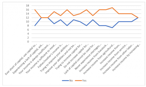
Based on interviews in the Figure 8 shows public ever short of capital use capital to optimize results 66%, experiencing a lack of capital ask the family 50%, income is always insufficient to meet all needs 50%, Your income is insufficient to meet all needs 62%, father/mother’s income is excessive to meet all needs 54%, trying to improve abilities there are obstacles 66%, improve abilities and not be hampered 54%, trying to increase capital for investment 58%, do not increase capital for investment 66%, lack of capital cannot be used for investment 54%, never experience shortages instead giving to those in need 66%, increase income from livestock business 66%, increase income from agricultural businesses 70%, increase income from transportation businesses 58%, increase income from service businesses 58%, increase income from other labor businesses 58%, and increase income by increasing working hours 50%.
Regarding “Gumuk” management, data shows that half of the informants said that the income from “Gumuk” was insufficient for living needs, so they also sought additional income from livestock, agriculture, transportation, services, and other labor.
4.3 Community-based education concept
The best way to create a society that upholds environmental ethics and sustainability ideals is via education. There are several educational options available, ranging from kindergarten to university. Therefore, the long-term objective of environmental education is to create citizens who are aware of the biophysical environment and the issues that are connected to it, to increase awareness so that people may effectively participate in action to create a better, livable future, and to inspire people to work on it.
Community-based education is a manifestation of the democratization of education through the expansion of educational services for the benefit of society. The community can develop and empower itself through education developed by the community. Community-based education can only exist and run well in certain aspects when a democratic atmosphere of life has grown and developed well. The community is capable and aware of the importance of empowerment. Degradation of the geomorphological physical environment of “Gumuk” can occur if the role of regional-level policy instruments cannot outline zoning for sustainable environmental management of “Gumuk” and local community participation is ignored.
Communities work to continually better their lives through educational and training opportunities provided by community-based educational institutions. From this, community-based education models or forms evolved. Some examples of community-based educational institutions are TKA/TPA, community-managed course institutions, Islamic boarding schools, etc.
In community-based education, the community is the master or owner of their own home. Other parties, in this case, the government, can only be partners whose function is to facilitate, fund, or accompany all activities related to community-based education without any element of imposing interests. A method that gives everyone in society the chance to enhance their knowledge and technology via lifelong learning is community-based education.
Chaiphar et al. [6] argue that the most important thing is that activities organized by community members are usually related to sustainable conservation of the environment and natural resources. Everyone in society understands that their way of life and existence depends on natural resources. They realize that if the environment is damaged, all members of society will suffer various economic and social effects.
So, there is a need for public education to provide an understanding that the existence of “Gumuk” in Jember is not just a random historical legacy but that there are benefits that can be obtained related to the existence of “Gumuk” in Jember. The advantage of “Gumuk” existence is not to exploit the results of the “Gumuk” mine but rather the benefit of “Gumuk” as a water catchment and a breaker for powerful wind gusts from the Indian Ocean. In this research, community-based education is carried out through various institutional activities held by the community.
In the data obtained, as shown in Figure 9, the community is very enthusiastic about participating in institutional cooperation activities; in contrast to the “Gumuk” Association activities, fewer people experience. This shows a need for more public awareness in understanding the sustainability of “Gumuk”. This can also encourage environmental degradation. The community environment is the third educational institution after education in the family and school environments. Meanwhile, the concept of the social environment is as follows: Society can be interpreted as a form of social life system with its values and culture. Society is a forum and vehicle for education, the diverse field of human life (plural: ethnicity, religion, work activities, education level, socio-economic level, and so on).
Figure 9. Institutional activities
Parmin et al. [28] assessed scientific concepts with local wisdom. Most students, or 85% of them, have been able to show the relationship between science and local knowledge. Literature studies, observations, and interviews can be applied simultaneously to complete information about local wisdom identified following scientific concepts. Education for prospective science teachers must emphasize the skills to explore learning resources from the physical and sociocultural environment to enrich their understanding of scientific concepts.
Figure 10. Work on dump land
In this research, as shown in Figure 10, community-based education is carried out through institutional activities, including cooperation activities, village institutions, social networks, and “Gumuk” associations. Most jobs in the villages studied are agricultural laborers and farmers; a few are employees, traders, and others. Most people in the villages learned husband and wife work on “Gumuk” outside their town, as well as a small number in their village and outside the Kaliwates sub-district. Meanwhile, 45% of jobs other than in the “Gumuk” fields work outside the town. It is easy for residents of Tanah “Gumuk” village to find work.
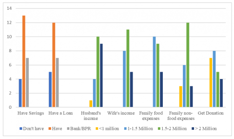
The data obtained regarding financial problems in Figure 11 shows that many people have savings, with a percentage of around 84% of residents having savings. Meanwhile, the number of people who have loans is 79%. The income of husbands in “Gumuk” land is that 17% of residents have revenues of 1-1.5 million, 42% have incomes of 1.5 - 2 million, and 31% have incomes above 2 million. Meanwhile, around 46% of people’s wives earn from 1.5 - 2 million. Meanwhile, most families spend 1-2 million each for food and non-food expenses. The “Gumuk” land community also received cash assistance from > 1-2 million.
Figure 11. Financial charts
Local wisdom plays a vital role in environmental sustainability in areas such as Jember, where the ecological potential has a lot of “Gumuk”; by implementing local wisdom, people are not easily tempted to exploit or sell their land, which the new owner then uses. Applying local wisdom in preserving “Gumuk” is the government’s basis for creating conservation policies. This knowledge produces action in the form of community-based local wisdom, namely how people work together, help each other, and reduce workload for public and personal interests. Maintaining the “Gumuk” is a natural manifestation of the implementation of the local wisdom of the Jember community, which must be preserved and maintained continuously and sustainably basis for creating conservation policies. Therefore, local governments will be assisted in formulating policies based on local community wisdom. Community-based education is a mechanism that provides opportunities for everyone in society to enrich knowledge and technology through lifelong learning. With “Gumuk” in Jember and the surrounding area, the community’s social life will be managed using the applicable norms inherent in this capital.
Differences with previous research include: Previous research, development of a learning model based on local wisdom, is research that examines community participation in developing sustainable development of rural tourism, and the research carried out is a strategy to preserve and protect their community’s forests from exploitation.
Based on the research limitations explained previously, suggestions can be given for further research and various parties who will research the preservation of “Gumuk” land through community-based local wisdom. Among these suggestions are 1) To prove the effectiveness of “Gumuk” conservation through community-based local knowledge that can be applied to other areas where “Gumuk” land is found. 2) In future research, it is recommended to take more samples, which is aimed at better data accuracy. 3) There will likely be additional variables that influence many things in this research. 4) Conduct ongoing research to see and occasionally assess any changes in respondent behavior.
This research describes the sustainable environmental management of “Gumuk” Based on local community wisdom in Kaliwates District, Jember Regency, Indonesia. The author would like to thank all parties who have provided moral and material assistance to complete this research.
[1] Wagiran, W. (2012). Pengembangan karakter berbasis kearifan lokal hamemayu hayuning bawana (Identifikasi Nilai-Nilai Karakter Berbasis Budaya). Jurnal Pendidikan Karakter, 3(3): 329-339. https://doi.org/10.21831/jpk.v0i3.1249
[2] Rosihan, A. (2012). Stereotipisasi Etnis Pribumi atas Etnis Pendatang (Studi Deskriptif Stereotip pada Etnis Komering atas Etnis Jawa: Studi Kasus di SMA Negeri 1 Martapura, OKU Timur, Sumatera Selatan). Program Studi Pascasarjana Kekhususan Ilmu Komunikasi, Fakultas Ilmu Sosial dan Ilmu Politik, Universitas Indonesia. Diakses http://lib.ui.ac.id/file=digital/20307922-T.
[3] Timur, B.P.P.J. (2024). Kabupaten jember, perwakilan provinsi jawa timur. BPK Perwakilan Provinsi Jawa Timur. https://jatim.bpk.go.id/
[4] Jember, K.K.S. (2012). Buku Putih Sanitasi Kabupaten Jember. Nawasis, Jember, Indonesia.
[5] Vitasurya, V.R. (2016). Local wisdom for sustainable development of rural tourism, case on Kalibiru and Lopati village, province of Daerah Istimewa Yogyakarta. Procedia-Social and Behavioral Sciences, 216: 97-108. https://doi.org/10.1016/j.sbspro.2015.12.014
[6] Chaiphar, W., Sakolnakorn, T.P.N., Naipinit, A. (2013). Local wisdom in the environmental management of a community: Analysis of local knowledge in Tha Pong Village, Thailand. Journal of Sustainable Development, 6(8): 16. http://doi.org/10.5539/jsd.v6n8p16
[7] Sugiyono. (2009). Metode Penelitian Kualitatif Kuantitatif dan R & D. Alfabeta, Bandung, Indonesia.
[8] Wahono, F., Widyanta, A.B., Kusumajati, T. (2005). Pangan, Kearifan Lokal dan Keanekaragaman Hayati. Yogyakarta: Cindelaras Pustaka Rakyat Cerdas.
[9] Jupri, A. (2019). Kearifan Lokal.LPPM Unram Press, Mataram, Indonesia.
[10] Aulia, T.O.S., Dharmawan, A.H. (2010). Kearifan lokal dalam pengelolaan sumberdaya air di Kampung Kuta. Sodality: Jurnal Transdisiplin Sosiologi, Komunikasi, dan Ekologi Manusia, 4(3): 345-355.
[11] Kriyantono, R. (2006). Teknik Praktis Riset Komunikasi, Jakarta: Kencana. Prenada Group.
[12] Nasiwan. (2012). Dari Kampus UNY untuk Indonesia Baru. Penerbit ARTI, Yogyakarta, Indonesia.
[13] Sudarmin, E.S.R.P., Pujiastuti, R.S.E., Skm, M. (2015). Scientific knowledge based culture and local wisdom in karimunjawa for groeing soft skills conservation. International Journal of Science and Research (IJSR), 4(9): 75-82.
[14] Khoiriyah, N.S., Nurul, U., Qodriyah, L., Parawangsa, M.D., Fatimah. (2019). Sebaran dan kondisi perbukitan kecil (Gumuk) yang berkontribusi dalam mengurangi bencana alam topan di Kabupaten Jember Jawa Timur Indonesia. In Internal Conference.
[15] Lingkungan, K.P. (2000). Program Konservasi Ekosistem Gumuk di Daerah Jember - Jawa Timur. Retrieved from http://kepel.itgo.com/gumuk/.
[16] Purwanto, D., Fitri, I., Pitaloka, C.A. (2021). Tinjauan yuridis alih fungsi kawasan Gumuk untuk kepentingan perumahan dan pemukiman di Kabupaten Jember. Fairness and Justice: Jurnal Ilmiah Ilmu Hukum, 19(2): 140-150. https://doi.org/10.32528/faj.v19i2
[17] Saisabela, I.C., Fauziyah, F. (2017). Tinjauan Yuridis Kebijakan Pemerintah Kabupaten Jember Terhadap Eksploitasi Gumuk. MIMBAR YUSTITIA: Jurnal Hukum dan Hak Asasi Manusia, 1(2): 166-184. https://doi.org/10.52166/mimbar.v1i2.1098
[18] Aprillian, E.I. (2020). Identifikasi Struktur Bawah Permukaan Pada Gumuk dan Lahan Bekas Gumuk Menggunakan Metode Geolistrik Resistivitas Konfigurasi Wenner-Schlumberger (Studi Kasus: Desa Sumberkalong Kecamatan Sukowono Jember) (Doctoral dissertation). http://repository.unej.ac.id/handle/123456789/97674.
[19] Astutik, L.T. (2015). Pemetaan pola sebaran Gumuk menggunakan metode sistem informasi geografis di Kabupaten Jember. Universitas Jember.
[20] Prasetyo, H., Setijanti, P., Faqih, M. (2021). Konsep Penataan Ruang Terbuka Hijau Gumuk di Lingkungan Perumahan Formal (Studi Kasus Real Estate di Kota Jember). Jurnal Teknik ITS, 10(2): D223-D228. https://doi.org/10.12962/j23373539.v10i1.59314
[21] Purwadhi, F.S.H., Sanjoto, T.B. (2008). Pengantar Interpretasi Citra Penginderaan Jauh. BAB III: Dasar Interpretasi Citra Penginderaan Jauh.
[22] Ellis, E., Pontius, R. (2007). Land-use and land-cover change. Encyclopedia of earth, 1: 1-4.
[23] Hariani, S.A., Irawati, M.H., Rahman, F., Syamsuri, I. (2015). Peran Serta Masyarakat Dan Pemerintah Dalam Upaya Konservasi Gumuk Di Kabupaten Jember. Saintifika, 17(2): 47-58. https://jurnal.unej.ac.id/index.php/STF/article/view/2736.
[24] Utomo, C.B., Kurniawan, G.F. (2017). Bilamana tradisi lisan menjadi media pendidikan ilmu sosial di masyarakat Gunungpati. Harmony: Jurnal Pembelajaran IPS dan PKN, 2(2): 169-184.
[25] Briassoulis, H. (2020). Analysis of Land Use Change: Theoretical and Modeling Approaches. West Virginia: WVU Research Repository.
[26] Bakosurtanal. (2007). Badan Koordinasi Survey dan Pemetaan Nasional. Perpustakaan Nasional RI.
[27] Widodo, L. (2003). Gumuk pasir parangtritis konversi versus konservasi (Sebuah Tinjauan Penggunaan Lahan Dengan Model Dinamik). Jurnal Teknologi Lingkungan, 4(1): 21-26. https://doi.org/10.29122/jtl.v4i1.268
[28] Parmin, Sajidan, Ashadi, Sutikno. (2015). Skill of prospective teacher in integrating the concept 1 postgraduate program. Sebelas Maret University, Indonesia. https://doi.org/10.15294/jpii.v4i2.4179